Turkey Creek Streamway Corridor
|
|
|
- Amelia Sullivan
- 5 years ago
- Views:
Transcription

1 Turkey Creek Streamway Corridor
2 Turkey Creek Corridor Overview History Watershed Corridor Inventory Coalition Corridor Plan Stages of Development Benefits Funding


3 Turkey Creek History Kansas and Missouri River confluence Kawsmouth Inhabited by Paleo-Indians over 12,000 years ago Wet-mesic bottomland forest and tall grass prairie Settled by Euro-American explorers and traders Named Turkey Creek for wild turkeys in the area

 Rosedale WWI")
4 Turkey Creek Historic Landmarks Old Rosedale City Hall & Fire Station No. 1 (1912) Rosedale WWI Memorial Arch ( )


5 Watershed History Surveyed in 1833 by Isaac McCoy Burlington Northern RR 1860 s Disastrous flooding in 1919 Tunnel constructed in 1920 Highway construction 1940 s Plaza Flood in 1977


6 Watershed Planning COE Flood Study 1987 Environmental degradation Natural resource inventory COE Watershed Plan 2007 Urban ecosystem restoration Habitat conservation Recreation and trails


7 Environmental Enhancement Area COE Project Riparian Corridor Restoration Habitat Conservation Native Plantings Trails Recreation

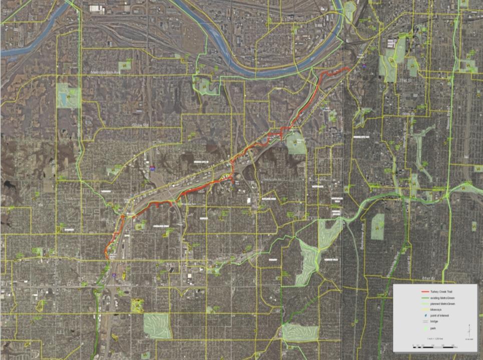
8 Turkey Creek Corridor

9 Merriam Market Trail Head

10 Merriam Turkey Creek

11 Merriam Turkey Creek Trail

12 Merriam Waterfall Park

13 Merriam RR Bridge

14 Merriam I-35 Bridge

15 Overland Park I-35 / Antioch

16 Overland Park I-35 Corridor

17 Overland Park Turkey Creek

18 Overland Park Metcalf / I-35

19 Mission Metcalf Bridge

20 Mission Turkey Creek

21 Mission Former road bed

22 Mission Adjacent to I-35

23 Kansas City, Kan. I-35 / 21 st St.

24 KC, Kan. 21 st St. RR

25 KC, Kan. 21 st St. Bridge

26 KC, Kan. Bridge view

27 KC, Kan. Merriam Lane

28 KC, Kan. Turkey Creek

29 KC, Kan. Near Drive-In

30 KC, Kan. Turkey Creek

31 KC, Kan. Drive-In

32 KC, Kan. RR Bridge


33 KC, Kan. Lake Ave.

34 KC, Kan. Mill St./I-35 ramp

35 KC, Kan. Turkey Creek

36 KC, Kan. Mill Bridge / I-35

37 KC, Kan. Bridge view

38 KC, Kan. I-35 on-ramp

39 KC, Kan. Merriam Dr. / SW Blvd.

40 KC, Kan. Division St.

41 KC, Kan. I-35 / 7 th St Tfwy

42 KC, Kan. Former I-35 ramp
43 Turkey Creek Coalition Merriam Mission Overland Park Roeland Park Johnson County Unified Government of Wyandotte Co. Mid-America Regional Council Former State Representative Ronnie Metsker Representative Dennis Moore s Office U.S. Army Corps of Engineers Kansas Department of Transportation

44 Future Corridor Plan

45 Corridor Connections


46 Benefits of Greenways and Trails Transportation Health and Safety Water Quality and Environmental Economic
47 Transportation Benefits Environmentally friendly transportation choices Unique experience not possible by automobile Alternative for commuting to places people live, work and play
48 Health and Safety Benefits Encourage physical activity Promote recreation and mental relaxation Connect people to nature Provides safe off-street access to places Increases visibility in an area (prove to prevent crime and increase public security)
49 Environmental Benefits Prevent flood damage Maintain and improve water quality Provide streambank stability Provide habitat for wildlife Promote environmental education
50 Economic Benefits Encourage business development Lower cost of stormwater management Increase property value Increase tourism Enhance quality of life in the community


51 Stages of Development Feasibility Study Concept Plan Multi-jurisdictional Plan Adoption Preliminary Engineering/Design Construction Design Bidding and Letting Construction Maintenance
52 Trail Funding Federal Transportation Funding Non-Transportation Federal Funding and Assistance State and Local Government Funding Corridor Revenue Private Funding Sources Partnerships Events Volunteer Opportunities
53 Federal Transportation Funding Recreational Trails Program (RTP) Transportation Enhancements Program (TE) Congestion Mitigation and Air Quality (CMAQ) Safe Routes to School (SRTS) Transportation, Community and System Preservation Program (TCSP) Federal Lands Highway Program (FLHP) National Scenic Byways Program Alternative Transportation in Parks and Public Lands Park Roads and Parkways Program (PRPP)
54 Other Federal Funding/Assistance National Recreation Trails (NRT) Rails, Trails and Conservation Assistance Program (RTCA) Land and Water Conservation Fund (LWCF) Community Development Block Grant Program (CDBG) Urban and Community Forestry (UCF) Public Works and Economic Development Program Preserve America (Historic Preservation) Save America s Treasures (Historic Preservation) EPA Brownfields Program National Coastal Wetlands Conservation Program Corporate Wetlands Restoration Partnership Natural Resource Conservation Service
55 State and Local Funding Departments of Health, Parks, Conservation or Transportation Capital Improvement Programs Bond Issues Heritage Trusts
56 Private Funding Campaigns and Donations Foundations and Company Grants Bikes Belong Coalition Kodak American Greenways Awards Program National Trails Fund REI Outdoor Goods Store Conservation Alliance Wal-Mart Foundation
57 the big secret
58 Thank You Contact: Name Phone
Yadkin River Greenway Feasibility Study Fact Sheet Village of Clemmons, Town of Lewisville, Town of Bermuda Run
 Fact Sheet Village of Clemmons, Town of Lewisville, Town of Bermuda Run Project Background The Yadkin River Greenway Feasibility Study is a joint project with the Village of Clemmons, the Town of Bermuda
Balancing Conservation and Development on the Jordan River
 Balancing Conservation and Development on the Jordan River Jordan River Parkway Trail Regional Athletic Complex Conservation & Restoration Balancing Conservation and Development on the Jordan River Jordan
San Diego River Coalition 2012 Work Plan
 San Diego River Coalition 2012 Work Plan Adopted November 18, 2011 The mission of the San Diego River Coalition is preserve and enhance the San Diego River, its watershed, and its natural, cultural and
Holland Country Club Golf Course to Wetlands
 Holland Country Club Golf Course to Wetlands John Scholtz, Director Ottawa County Parks & Recreation Commission Amy A. Berry, Project Manager Niswander Environmental, LLC OTTAWA COUNTY PARKS: Focusing
Middle Mississippi River. Regional Corridor
 Middle Mississippi River St. Louis District Regional Corridor Lessons Learned from a Collaborative Planning Study Brian Johnson US Army Corps of Engineers 12 th Biennial Governor s Conference on the Management
RESPONSES TO PUBLIC CONCERNS AND QUESTIONS
 RESPONSES TO PUBLIC CONCERNS AND QUESTIONS Stations and Summary Questions for Public Meeting #2 June 23, 2015 General Questions / Concerns: 1. Is there any way this development can raise revenue for the
Chapter 5: Natural Resources and Environment
 NATURAL RESOURCES AND ENVIRONMENT 5-1 5 Chapter 5: Natural Resources and Environment BACKGROUND AND INTENT Urban expansion represents the greatest risk for the future degradation of existing natural areas,
Applied Ecological Services, Inc. Sustainable Solutions for Over 30 Years.
 Applied Ecological Services, Inc. Sustainable Solutions for Over 30 Years. Landfills Can Mitigate and Restore Riparian Impacts on Their Property Jason Dremsa, Construction Manager Applied Ecological Services,
Inventory and Management Recommendations for Future Recreational Needs
 Inventory and Management for Future Recreational Needs Greenway Corridor Draft Report Prepared for: Woodbury Park and Recreation Submitted by: Jon Benson, Project Manager Tara Grover, Mark Gustafson, Pamela
STREAM BUFFERS
 88-415 STREAM BUFFERS 88-415-01 PURPOSE In the Kansas City region and throughout the nation, vegetated stream buffers have been clearly shown to protect stream stability and related infrastructure, improve
Green Infrastructure. NYS Department of Environmental Conservation
 Green Infrastructure Green infrastructure is an interconnected network of natural areas and open spaces that sustains ecosystems. Benedict, M.A. and E.T. McMahon. 2006. Green Infrastructure Linking Landscapes
Parks, Open Space and Trails
 Introduction Parks have often been referred as the lungs of our cities, cleansing the air of pollutants and particulate matter. Parks are also gathering places for families and community. They offer spaces
Chapter 5: Recreation
 Chapter 5: Recreation Introduction and Setting Recreational opportunities within Nevada County are varied, ranging from public parks with intensively used active recreational facilities, to vast tracts
The Value Proposition of New Urban Parks in Small Cities: Exploring Newburgh, New York as a Prototypical Case Study
 The Value Proposition of New Urban Parks in Small Cities: Exploring Newburgh, New York as a Prototypical Case Study By Arianna Koudounas Georgetown MURP December 2015 SAFE HARBORS GREEN Newburgh, NY NOW
RECREATION, OPEN SPACE AND GREENWAYS ELEMENT GOALS, OBJECTIVES, AND POLICIES
 RECREATION, OPEN SPACE AND GREENWAYS ELEMENT GOALS, OBJECTIVES, AND POLICIES GOAL R-1: DEVELOP A RECREATION, OPEN SPACE AND GREENWAYS SYSTEM AS AN INTEGRAL COMPONENT OF AN OVERALL, COUNTY-WIDE ECONOMIC
The Trinity River Corridor Project Update
 The Trinity River Corridor Project Update Councilmember Carolyn A. Davis Community Meeting October 14, 2008 The project covers 20 miles of the Trinity River, approx. 10,000 acres 2 Trinity River Corridor
Potential Green Infrastructure Strategies May 6, 2015 Workshop
 Potential Green Infrastructure Strategies May 6, 2015 Workshop Background The City of Cortland is developing the Tioughnioga Urban Headwaters Green Infrastructure Action Plan with funding from the National
SUSTAINABILITY PLAN OTTAWA COUNTY PARKS AND RECREATION COMMISSION FALL 2017
 SUSTAINABILITY PLAN OTTAWA COUNTY PARKS AND RECREATION COMMISSION FALL 2017 Table of Contents Introduction Natural Resources Quality of Life Community Continuing the Mission Sustainability Measuring Sustainability
SITE INTRODUCTIONS AND OVERVIEW
 SITE INTRODUCTIONS AND OVERVIEW The City s formal Open Space Program was established in 1990 to implement long-standing policies that called for the protection of the farmlands and wild areas that surround
City of Iowa City Department of Neighborhood and Development Services Department of Parks and Recreation Department of Public Works City Manager s
 RFP Pre-submittal meeting December 18, 2015 City of Iowa City Department of Neighborhood and Development Services Department of Parks and Recreation Department of Public Works City Manager s Office Background
Conservation Corridor Base and Thematic Maps
 Conservation Corridor Base and Thematic Maps August 20, 2010 This project is funded in part by the Virginia Coastal Zone Management Program at the Department of Environmental Quality through Grant #NAO9NOS4190163
Chapter 11. Implementation Plan
 Chapter 11 Implementation Plan 127 D O W N T O W N T AV A R E S R E D E V E L O P ME N T MA S T E R P L A N IMPLEMENTATION PLAN This section shows how the Master Plan translates to a phased series of
Parks and Open Space Preservation and Dedication. January 26, 2016 Fort Worth City Council Pre-Council Meeting Randle Harwood and Richard Zavala
 Parks and Open Space Preservation and Dedication January 26, 2016 Fort Worth City Council Pre-Council Meeting Randle Harwood and Richard Zavala Purpose How does the City of Fort Worth preserve and protect
On the Map. Conservation Planning for the Kansas City Region. Mid-America Regional Council. Mid-America February Regional 2005Council
 On the Map Conservation Planning for the Kansas City Region Mid-America Regional Council Mid-America February Regional 2005Council Introduction In 2003, the Mid-America Regional Council (MARC) began developing
Great Rivers Greenway CLEAN GREEN CONNEC TED T RAILS
 Great Rivers CLEAN GREEN CONNEC TED T RAILS Great Rivers (GRG) was established in 2000 to create a clean, green, connected St. Louis region. Today, many new and exciting projects demonstrate the social,
A larger version of this map is located on the last page of this PDF.
 MAP Committee Input McLoughlin Area Draft Vision Map A larger version of this map is located on the last page of this PDF. 1. The map above is intended to portray a vision for the McLoughlin area. It highlights
National Association of Conservation Districts. Kris Hoellen Vice President, Sustainable Programs The Conservation Fund September 19, 2013
 National Association of Conservation Districts Kris Hoellen Vice President, Sustainable Programs The Conservation Fund September 19, 2013 Our Mission The Conservation Fund forges partnerships to conserve
Los Angeles River-Arroyo Seco Confluence Restoration Vision Plan. Professor Meredith McKenzie, JD Urban & Regional Planning Dept Cal Poly Pomona
 Los Angeles River-Arroyo Seco Confluence Restoration Vision Plan Professor Meredith McKenzie, JD Urban & Regional Planning Dept Cal Poly Pomona The Los Angeles River Watershed Arroyo Seco Watershed Map
SECTION FOUR: MISSION STATEMENT, GOALS & OBJECTIVES
 SECTION FOUR: MISSION STATEMENT, GOALS & OBJECTIVES Chapter Summary Chapter Ten: Mission Statement, Goals & Objectives To fulfill its mission, the Parks and Recreation Commission has identified four basic
UPPER BRODHEAD CREEK PARADISE CREEK GREENWAY PLAN
 UPPER BRODHEAD CREEK PARADISE CREEK GREENWAY PLAN The Upper Brodhead & Paradise Creeks Greenway Cooperating Municipalities Mount Pocono Borough Paradise Township Barrett Township Price Township Funding
Planning for Staten. Habitat Restoration and Green Infrastructure. Island s North Shore
 Habitat Restoration and Green Infrastructure Planning for Staten Island s North Shore Community Board 1 March 1, 2018 NYC Parks Forestry, Horticulture, and Natural Resources Funded by the NYS Department
CONSERVATION ELEMENT GOALS, OBJECTIVES, AND POLICIES
 CONSERVATION ELEMENT GOALS, OBJECTIVES, AND POLICIES Goal 4 To conserve, manage, appropriately use and protect the natural resources of the City ensuring continued resource availability and environmental
Green Infrastructure. by Karen Engel, NYS DEC. NYS Department of Environmental Conservation
 Green Infrastructure by Karen Engel, NYS DEC What is Green Infrastructure? For some it s all about water Green Infrastructure techniques use soils and vegetation to infiltrate, evapotranspirate, and/or
COASTAL CONSERVANCY. Staff Recommendation March 25, 2004 LOS ANGELES GREEN VISION PLAN. File No.: Project Manager: Marc Beyeler
 COASTAL CONSERVANCY Staff Recommendation March 25, 2004 File No.: 04-014 Project Manager: Marc Beyeler RECOMMENDED ACTION: Authorization to disburse up to $50,000 to the University of Southern California
Corridor Enhancements
 Corridor Enhancements Safety is MoDOT s first priority in widening and rebuilding I-70 across the state of Missouri. MoDOT also understands that the interstate - and its interchanges and overpasses - are
Lake O the Pines Master Plan Revision Public Information Meeting April 25 & 27, 2017
 Lake O the Pines Master Plan Revision Public Information Meeting April 25 & 27, 2017 Presented By Matthew Like, Lake Manager U.S. Army Corps of Engineers Fort Worth District US Army Corps of Engineers
Improving Communities Through the Arroyo Seco Sustainability Campaign and Watershed Assessment
 Improving Communities Through the Arroyo Seco Sustainability Campaign and Watershed Assessment Arroyo Seco Headwaters in the San Gabriel Mountains Major tributary to the Los Angeles River 44 square mile
Portage County Parks, Trails and Greenways Plan
 Portage County Parks, Trails and Greenways Plan Agenda for Local Planning Meeting Introductory Presentation Why we need a Plan Plan project goals and process Benefits Overview of local planning region
Longmeadow Parkway Fox River Bridge Corridor. August 6, 2015
 Longmeadow Parkway Fox River Bridge Corridor August 6, 2015 Longmeadow Parkway Bridge Corridor 5.6 miles from Huntley Road to IL 62 Unique municipal/county/state/federal partnership Links Randall Road
Get Connected: Balancing Built and Natural Environments for Sustainability
 Get Connected: Balancing Built and Natural Environments for Sustainability The Mid-South Regional Greenprint and Sustainability Plan seeks to connect a network of green space across Shelby County TN, Fayette
Objective: Resolution to recommend adoption of the Big Thompson Assessment to the Planning Commission
 Type of Meeting: Administrative Matters Name of requestor: Zac Wiebe - 619-4534, Kerri Rollins - 619-4577, Gary Buffington - 619-4560 Department: Natural Resources Preferred appearance date: 8/18/2015
Mendota-Lebanon Hills Greenway Master Plan Executive Summary. August draft for more information visit
 Mendota-Lebanon Hills Greenway Master Plan Executive Summary August 2013 draft for more information visit www.hkgi.com/projects/dakota INTRODUCTION The Mendota-Lebanon Hills Greenway Master Plan portrays
The Trust for Public Land. in Minnesota
 The Trust for Public Land in Minnesota Protecting Minnesota s Natural Legacy In Minnesota, The Trust for Public Land (TPL) is protecting strategic land and water resources for people to enjoy as parks,
This page intentionally blank.
 This page intentionally blank. Parks, Recreation, and Open Space Chapter Relationship to Vision Vision Parks, Recreation and Open Space Chapter Concepts County Government. County government that is accountable
Neuse River Corridor Plan
 The One NC Naturally Initiative will not be a large scale state buyout of land in North Carolina. Over the next 10 years, the Million Acre Initiative will provide incentives and information for voluntary
Working together to leverage limited Funds
 Working together to leverage limited Funds ARAPAHOE COUNTY OPEN SPACES 10 County Budget Conference September 20, 2013 The Power of Partnerships 2013 SORP Conference 5/23/2014 Why Talk About Open Space?
OVERMOUNTAIN VICTORY TRAIL BURKE CALDELL CORRIDOR FEASIBLITY STUDY REQUEST FOR QUALIFICATIONS CALDWELL COUNTY PATHWAYS
 OVERMOUNTAIN VICTORY TRAIL BURKE CALDELL CORRIDOR FEASIBLITY STUDY REQUEST FOR QUALIFICATIONS CALDWELL COUNTY PATHWAYS Caldwell County Pathways along with our co-partners City of Lenoir, Town of Gamewell,
G A R Y G R E E N L I N K APPENDIX A
 G A R Y G R E E N L I N K M A S T E R P L A N 1 American Bridge Property data American Bridge Property Manager 2 Little Calumet-Galien River Watershed Study Applied Ecological Services, Inc. 3 Final Assessment
City of Missoula and Missoula County Open Space Planning Open House
 City of Missoula and Missoula County Open Space Planning Open House FEBRUARY 6, 2018 The following slides contain the display board content from the open house. Please use boards to answer questions in
BOT Annual Meeting Webinar
 BOT Annual Meeting Webinar Agenda Public Awareness and Communications Government Affairs Education Professional Practice Networks Audio is via teleconference only Advocacy Update October 2013 The best
CHAPTER 8 ISSUES, CONCERNS, CONSTRAINTS AND OPPORTUNITIES
 CHAPTER 8 ISSUES, CONCERNS, CONSTRAINTS AND OPPORTUNITIES Introduction This River Conservation Plan was developed during a time of tremendous activity and effort in planning the transformation of the Delaware
Adopting the Manual of Best Management Practices for Stormwater Quality. Facts for Communities
 Adopting the Manual of Best Management Practices for Stormwater Quality Facts for Communities Adopting the Manual of Best Management Practices for Stormwater Quality September 2006 prepared for the Mid-America
Public Meeting May 20, 2014
 Public Meeting May 20, 2014 Overview Study Purpose Study Area Overview Strategies Potential Opportunities Implementation and Discussion Skeo Solutions Raleigh Walkable Watershed Pilot 2 Purpose Develop
Oroville Area Urban Greening Plan. Second Communitywide Workshop
 Oroville Area Urban Greening Plan Second Communitywide Workshop Monday, November 18, 2013 PROJECT TEAM Lead Agency Butte County Department of Development Services Claudia Stuart, Principal Planner Chris
{Best Practices. Summary of Tools, Strategies and Best Practices from 11 Michigan Case Study Communities
 Case Studies Michigan Coastal Community Working Waterfronts { Summary of Tools, Strategies and from 11 Michigan Case Study Communities Table of Contents Zoning...2 Community and Stakeholder Collaboration
CATEGORICAL EXCLUSION DETERMINATION I 435/I 35/K 10 INTERCHANGE (JOHNSON COUNTY GATEWAY)
") December 11, 2012 CATEGORICAL EXCLUSION DETERMINATION I 435/I 35/K 10 INTERCHANGE (JOHNSON COUNTY GATEWAY) Project Number: Kansas Department of Transportation (KDOT) Project No. 435-46 KA-1002-03 Route:
December 11, 2012 CATEGORICAL EXCLUSION DETERMINATION I 435/I 35/K 10 INTERCHANGE (JOHNSON COUNTY GATEWAY) Project Number: Kansas Department of Transportation (KDOT) Project No. 435-46 KA-1002-03 Route:
Transportation Projects Quarterly Report. Morrisville Planning Department May 22, 2018
 Transportation Projects Quarterly Report Morrisville Planning Department May 22, 2018 Transportation Improvements Most Common Ways the Town secures transportation improvements: 1. Development 2. Grant
City of Meriden Harbor Brook Flood Control Project Overview
 City of Meriden Harbor Brook Flood Control Project Overview Updated August 2013 OVERVIEW The center of Meriden, including the HUB site is the low point of the town which is ringed by basalt ridges. Running
2011 ASLA Design Awards. Westside Creeks Restoration Plan Merit Award AECOM, Fort Collins. Planning & Urban Design
 2011 ASLA Design Awards Westside Creeks Restoration Plan Merit Award AECOM, Fort Collins Planning & Urban Design Project Fact Sheet Category of Entry: Rotating Specialty Award: 2011 2011 ASLA Colorado
138 ATTACHMENT 17. DEPARTMENT OF THE ARMY WlLMlNGTON DISTRICT, CORPS OF ENGINEERS
 138 ATTACHMENT 17 DEPARTMENT OF THE ARMY WlLMlNGTON DISTRICT, CORPS OF ENGINEERS B. EVERETT JORDAN DAM AND LAKE P.O. Box 144 MONCURE, NORTH CAROLINA 27559 April 11, 2007 Mr. Scott Radway Radway Design
Plan-It Greenville (2009) Comprehensive Plan 5-Year Update
 Comprehensive Plan 5-Year Update") Plan-It Greenville (2009) Comprehensive Plan 5-Year Update What is the comprehensive plan: Collecting communitywide data Projecting future population growth Setting communitywide goals Framing policies
Plan-It Greenville (2009) Comprehensive Plan 5-Year Update What is the comprehensive plan: Collecting communitywide data Projecting future population growth Setting communitywide goals Framing policies
South Davis County COMMUNITY SPOTLIGHT
 South Davis County COMMUNITY SPOTLIGHT Davis/SLC Community Connector Bus Rapid Transit line connecting SLC & Davis County RTP Phase 1 Project Generate 3,100 average weekday riders Relieve congestion on
Municipality of Anchorage. Community Council Survey Capital Projects Needs Ranking Survey (ALPHABETICAL) Airport Heights
 Airport Heights") ANCHORAGE PARKS & RECREATION Nichols Park Design and improve neighborhood park 2008 Challenge Grant applicant. 2008 $500K State Grant for Neighborhood Parks. Tikishla Park Lighting, paved parking, hockey
ANCHORAGE PARKS & RECREATION Nichols Park Design and improve neighborhood park 2008 Challenge Grant applicant. 2008 $500K State Grant for Neighborhood Parks. Tikishla Park Lighting, paved parking, hockey
Town of Peru Comprehensive Plan Executive Summary
 Town of Peru Comprehensive Plan Executive Communities that plan grow by choice, not by chance. A plan makes growth thoughtful, understandable, and predictable. A plan shows that a community is managing
TABLE OF CONTENTS. Transportation Chapter 1 - Introduction and Purpose of Planning to 1-3. Utilities
 Chapter 1 - Introduction and Purpose of Planning... 1-1 to 1-3 Pennsylvania Municipalities Planning Code (Act 247)...1-1 Previous County Planning Activities...1-1 Objectives of the Plan...1-2 Elements
Flooding Hearing: Long and Short Term Strategies
 Services of the San Francisco Public Utilities Commission Flooding Hearing: Long and Short Term Strategies Presentation to San Francisco Board of Supervisors Public Safety and Neighborhood Services Subcommittee
Whitemarsh Township Greenway Plan
 Whitemarsh Township Greenway Plan Prepared for: Whitemarsh Township August 16, 2007 Table of Contents Table of Contents... i Introduction... 1 Study Area Setting... 2 Regional Setting... 2 Township Character...
6.0 Conclusions & Recommendations
 6.0 Conclusions & Recommendations 75 The research, public outreach and feasibility analysis completed for this study indicate that Trail Alternative #2 (South side of Doctors Creek) is the most comprehensive
124 Subarea Visions. Vision Plan. A. Nelessen Associates, INC I Visioning I Planning I Urban Design
 Subareas 124 Subarea Visions The next seven sections describe specific recommendations tailored to each subarea. Each subarea is discussed separately except for certain aspects of 95th Street and Antioch
BUDGETING FOR OUTCOMES TRINITY RIVER CORRIDOR
 BUDGETING FOR OUTCOMES TRINITY RIVER CORRIDOR Trinity River Corridor Team Members: Kelly High, Streets Department Megan Lam, Office of Financial Services Mike Mikeska, Dallas Water Utilities Diana Ochoa,
Mendota Heights 2040 Comprehensive Plan Draft Vers
 4 Parks and Trails The City of Mendota Heights boasts a variety of recreational and open space opportunities. Few cities can claim access to regional trails, riverside and lakeside parks, scenic bluffs
Regional Context Statement
 Regional Context Statement REGIONAL CONTEXT STATEMENT 3. REGIONAL CONTEXT STATEMENT In 1995, the Provincial Government passed into law the Growth Strategies Act. The purpose of this provincial initiative
AREA-WIDE PEDESTRIAN AND BICYCLE CIRCULATION
 OUSD LANEY CHILD CARE CENTER ART BUILDING LANEY COLLEGE BALL FIELDS PCCD OFFICES PERALTA PARK AQUATIC CENTER & ESTUARY PARK EDOFF MEMORIAL BANDSTAND SNOW PARK COURT HOUSE OAKLAND MUSEUM OAK ST AREA-WIDE
Steering Committee 3. September 17, :30-7:30pm. Welcome.
 Steering Committee 3 September 17, 2015 5:30-7:30pm Welcome DOG RIVER www.makingwatershedswork.org Agenda 1. Welcome 2. Scientific Research: Water Quality 3. Current and Relevant Planning 4. Community
Oroville Area Urban Greening Plan. Joint Meeting of the Oroville Planning, Park, and Arts Commissions October 12, 2015
 Oroville Area Urban Greening Plan Joint Meeting of the Oroville Planning, Park, and Arts Commissions October 12, 2015 Project Team Lead Agency Butte County Department of Development Services Claudia Stuart,
Riparian Buffer on the Bushkill Creek. Policies
 Riparian Buffer on the Bushkill Creek Riparian buffers provide numerous benefits to landowners and the community by protecting groundwater recharge areas, providing flood control, providing stormwater
NEW GRANTS PROGRAM. Today I will describe what green infrastructure planning entails, how the model works and the importance of the work to planners!
 NEW GRANTS PROGRAM The South Carolina Forestry Commission received funds from the USDA Forest Service s Southern Region to build a green infrastructure landscape scale model and to fund several implementation
Civic Greenway Natural Features Map. Astoria Riverfront Vision Plan The City of Astoria, Oregon December 2009
 67 Civic Greenway Natural Features Map 68 Land Use and Urban Design It is expected that large amounts of overwater development will not occur in the Civic Greenway area due to the amount of public control
STP/SNK BIKE AND PEDESTRIAN PROJECTS
 STP/SNK BIKE AND PEDESTRIAN PROJECTS Project Name West Covington Riverfront Commons - Shared Use Path Applicant Name City of Covington, KY Applicant Title Mayor Joseph Meyer Email jumeyer@covingtonky.gov
SECTION 9 PUBLIC FORUM DRAFT 5/31/2017 SEVEN YEAR ACTION PLAN
 SECTION 9 SEVEN YEAR ACTION PLAN The Seven-Year Action Plan addresses the objectives of the Open Space and Recreation Plan and identifies actions to meet these objectives. While the Open Space and Recreation
Welcome to the. Open House
 Welcome to the 5th Street to Kinsman Road Open House November 14 5:30 7:00 p.m. Please sign in Project Overview In December 2016, City Council adopted SW 5th Street as the preferred alignment to connect
Urban runoff in my neighborhood (Capitol Hill) is heavy with trash and other debris.
 is heavy with trash and other debris.") South Platte River Meeting Comments & s #1 I am a huge fan of river areas and would love the Platte and surrounding waterways to improve to allow habitat for wildlife and recreation opportunities for citizens.
South Platte River Meeting Comments & s #1 I am a huge fan of river areas and would love the Platte and surrounding waterways to improve to allow habitat for wildlife and recreation opportunities for citizens.
KCATA Transit Oriented Development Initiatives
 KCATA Transit Oriented Development Initiatives KCATA: Regional Transportation Authority Created by bi-state compact Approved by Congress 7 County service area Quasi-governmental with broad powers Power
KISHWAUKEE MUNICIPALITIES PLAN FOR SUSTAINABLE DEVELOPMENT
 KISHWAUKEE MUNICIPALITIES PLAN FOR SUSTAINABLE DEVELOPMENT 4 "Natural areas, parks and open space create a high quality of life that attracts tax-paying businesses and residents to communities." Trust
Green Infrastructure Planning for Sustainability and Resiliency
 Green Infrastructure Planning for Sustainability and Resiliency Linking Lands and Communities in the Land-of-Sky Region SAMAB Conference - November 18, 2010 www.linkinglands.org Linda Giltz, AICP, Regional
Rosemount Greenway Master Plan Executive Summary. draft. Spring for more information visit
 Rosemount Greenway Master Plan Executive Summary Spring 2012 draft for more information visit www.hkgi.com/projects/dakota INTRODUCTION The Rosemount Greenway Master Plan portrays a vision to establish
Chagrin River Watershed Partners, Inc. Local Regulations. Amy H. Brennan (440)
") Chagrin River Watershed Partners, Inc. Local Regulations Amy H. Brennan (440) 975-3870 www.crwp.org abrennan@crwp.org July 9, 2013 Applicable Zoning and Building Codes Erosion and Sediment Control Grading
Chagrin River Watershed Partners, Inc. Local Regulations Amy H. Brennan (440) 975-3870 www.crwp.org abrennan@crwp.org July 9, 2013 Applicable Zoning and Building Codes Erosion and Sediment Control Grading
Town of Lyons Parks Flood Recovery Planning Process. Photograph courtesy of Ed Bruder
 Town of Lyons Parks Flood Recovery Planning Process Photograph courtesy of Ed Bruder Lyons Parks and Recreation Flood Recovery Update 1. Meadow Park Phase II - Project PW20B1 Estimated Completion: Summer
The following principles guide the development of goals and strategies to protect and promote these amenities:
 OPEN SPACE/PARKS/TRAILS/RECREATION GOALS/STRATEGIES Cherry Hills Village is a living environment that offers low density development, open areas, public scenic vistas, public trails and public parks. This
CHAPTER 5: IMPLEMENTING THE 2030 PLAN
 CHAPTER 5: IMPLEMENTING THE 2030 PLAN GENERAL Each decision by the County Commissioners and recommendation made by the Planning Commission has the potential to contribute to or take away from the implementation
Gaining Consensus for Green Infrastructure Rain to Recreation
 Gaining Consensus for Green Infrastructure Rain to Recreation May 2nd, 2017 Tom Jacobs, PE, CFM Stormwater Engineer City of Lenexa Ronald L Norris, PE, PWLF Affiliated with Shockey Consulting Rain to Recreation:
Preparing Hudson River Waterfronts for an Era of Rapid Sea Level Rise
 Preparing Hudson River Waterfronts for an Era of Rapid Sea Level Rise CITY OF KINGSTON TIDAL WATERFRONT FLOODING TASK FORCE Gregg Swanzey Director, Office of Economic Development & Strategic Partnerships,
COLLIER BOULEVARD (CR 951) CORRIDOR
 CORRIDOR") Project(s) Goals Improve Traffic Circulation, Capacity & Safety Focus on Safety During Design & Construction Address Public Concerns Design an Aesthetically Pleasing Project Limit Environmental Impacts
Project(s) Goals Improve Traffic Circulation, Capacity & Safety Focus on Safety During Design & Construction Address Public Concerns Design an Aesthetically Pleasing Project Limit Environmental Impacts
Section 4: Goals, Objectives, and Strategies
 99 Section 4: Goals, Objectives, and Strategies Goal 1 Resource Protection, Maintenance, Preservation, and Enhancement Protect, preserve, maintain, and enhance the natural, recreational, archaeological,
Urban Greening Plan Proposed Policies and Programs Matrix Existing City Plans and Goals Programs Policies Notes/Comments
 Urban Greening Plan Circulation Plan for Bicyclists and Pedestrians (2007) 1.1 - Develop a coordinated Trail Maintenance Volunteer Program that identifies funding and leverages community efforts and partnerships
The City shall enhance and improve the accessibility of parks and recreational facilities while protecting their quality. by:
 GOALS, OBJECTIVES AND POLICIES GOAL 1: To provide open space and recreation as an essential element needed for the betterment of the City s character and quality of urban life. The City shall plan for
To qualify for federal Transportation Enhancement (TE) funds a project must meet two basic federal requirements:
 funds a project must meet two basic federal requirements:") Eligibility Requirements To qualify for federal Transportation Enhancement (TE) funds a project must meet two basic federal requirements: 1) Relate to surface transportation and 2) Be one of the 12 designated
Eligibility Requirements To qualify for federal Transportation Enhancement (TE) funds a project must meet two basic federal requirements: 1) Relate to surface transportation and 2) Be one of the 12 designated
Development Reviews. An overview of the Commission s review process, primarily in Klickitat County. March 13, 2018
 Development Reviews An overview of the Commission s review process, primarily in Klickitat County March 13, 2018 Who should a landowner work with? Oregon Counties Washington Counties Multnomah County Land
Rouge River Gateway Master Plan Update: 2011
 Rouge River Gateway Master Plan Update: 2011 Environmental Stewardship Cultural Heritage Recreation Economic Development Rouge Gateway Master Plan (2001) 1 Rouge Gateway Master Plan Update (2005) Significant
The Mobile Peninsula Corridor Master Plan Dauphin Island Parkway I 10 to Dog River
 The Mobile Peninsula Corridor Master Plan Dauphin Island Parkway I 10 to Dog River Welcome and Introductions Alice Keel Co Founder Prayer Rev. Jim Langston Fulton Road Baptist Church Comments Stewart Hanley,