REDMOND CENTRAL CONNECTOR ART & DESIGN MASTER PLAN
|
|
|
- Marsha Nash
- 5 years ago
- Views:
Transcription

1 REDMOND CENTRAL CONNECTOR ART & DESIGN MASTER PLAN


2 Redmond Central Connector Master Plan design principles principles make it redmond: past, present, future not just a place with art, a place that is art Several overriding opportunities emerged throughout the master plan design process and were embraced by the design team, City staff and the public. These ideas have inspired and guided the design of the master plan and should continue to shape the implementation of the Redmond Central Connector. Make the Connector unique to Redmond. Honor and celebrate Redmond s past, but do not try to artificially recreate it. Acknowledge Redmond of today and welcome its evolution into the future by making the Connector a forward-looking place. Celebrate and welcome the opportunity for the Connector to evolve over time for a future we cannot predict. Save and reuse historic elements from the railroad in new and imaginative ways to bring history to life and give them new use. Celebrate connections to existing historic structures such as the Justice White House and to others in Downtown through connections beyond the corridor. Create a structure for celebrating history through integrated art, to be implemented and changed over time, allowing responsiveness to the current cultural climate. The Connector presents the opportunity not only to house art, but to be art and to be a catalyst to shape an ever more artistically engaged community. The master plan is shaped at its most basic structure by the artdriven concept of Fluctuations, detailed in Section 3.0. Within the Connector there are numerous layers of art and art opportunities, ranging from art integrated into the design of functional elements of the corridor, permanent commissioned pieces of art to changing curated collections. Required design elements in the Connector such as bollards, furnishings and visual utility elements should be completed in a more artful way, starting with site restoration after installation of the trunk line producing inspired landforms and interim art where seeded meadow would typically suffice. Imagine the corridor as a catalyst for Redmond becoming home to artists and their studios. 18


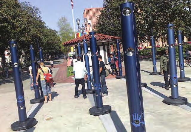
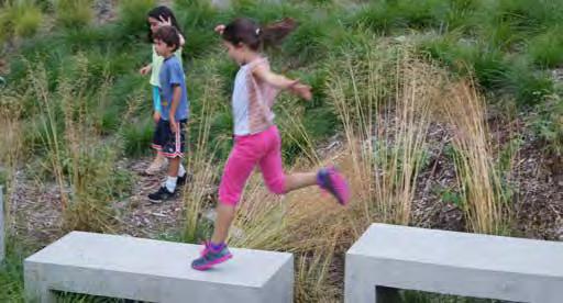
3 make it magnetic... connect the community catalyst for commerce design PRInciples Create design elements that provide visual interest and invite physical The physical connections made by the Connector are key to The confines of the corridor are not enough to realize the vision for interaction. This magnetic quality should encourage users of the physically connecting the City. The more ambitious and rewarding the Connector. The City around it must do its part by activating the corridor to be engaged, to linger longer in specific spaces, and can goal is for the Connector to create connections between people. The corridor and broader Downtown with the commerce and activity also be a means to encourage visitors to move down the Connector to Connector will create experiences that bring strangers together in that comes with it. The Connector can be both a catalyst for and a more distant areas beyond their planned destination. These corridor sharing a common experience and making personal connections that beneficiary of new commerce and the urban activity that comes with it qualities will also influence the unique design of private development might otherwise not occur. as new businesses choose to front on Redmond s iconic public space along the Connector. Interactive creations can connect people by drawing individuals in yet and people solicit those businesses and activate the surrounding park spaces. Imagine human-scale building blocks that users of the corridor can requiring more than one person to fully activate the artwork or park move to make their own creations. Imagine a stormwater feature element. Imagine a game that requires recruiting multiple players to Buildings that currently turn their back on the Connector will be re- where you control the flow of water. Imagine a zen-like garden play. Imagine mobile elements that require multiple people to move imagined to front on it. A range of appropriate commercial uses such where you create never before made patterns. Imagine a puzzle that them. as restaurants, athletic clubs, galleries and artist studios will spill out requires and inspires you to walk the whole of the corridor to solve of buildings to outdoor spaces, blurring the line between the public the challenge. Imagine furnishings and canopies that can be moved, Connector and the adjacent private developments. Those attracted to opened and closed by you to respond to sun, shade and rain. Downtown Redmond for its retail and cultural quality will enhance their Downtown experience with a stroll down the Connector. 19


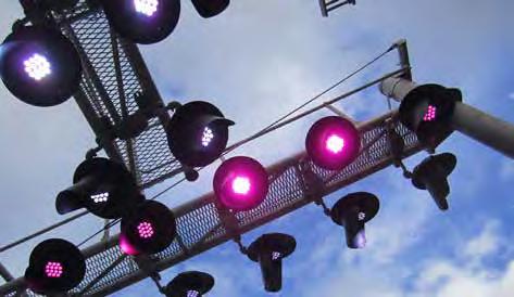
4 Redmond Central Connector Master Plan design principles Capture the sky Celebrate the weather experience the night The Connector is a significant space in the heart of the City, yet the park and trail experience gets as narrow as 30 feet between the buildings and future light rail transit way. Properties on the north side of the Connector may reach 65 feet or higher, and light rail catenary structures to the south can reach as high as 30 feet. Recognizing the narrow, linear quality and surrounding height, the treatment of the space above the corridor becomes a critical opportunity to enhance the corridor experience, celebrating the urban canyon quality, or helping to mitigate it. Portions of the Connector could be deliberately kept free of vertical and overhead obstructions, maximizing the valued open space to the sky as a welcomed relief. Conversely some spaces might create an overhead presence, be it lighting, vegetation, overhead canopy or art, emphasizing the space as an outdoor room both utilizing adjacent verticals and mitigating them. Another opportunity is to utilize the space over the Connector for park elements, particularly art, which might not best fit on the ground, helping turn people s eyes to the sky. The Connector, as with all parks, will be a heavily used and sought after destination in times of dry weather, and particularly so in warmer weather. The opportunity of the Connector is to continue to be that destination year round, continuing to be a gathering place and catalyst for community life in all types of weather. Instead of simply trying to mitigate what might be considered inclement weather, the Connector seeks to celebrate it and use it as one of the elements that gives the Connector its identity. Rain it s in our DNA and the corridor seeks to celebrate it in a way that Redmondites will say, it s raining, let s go down to the Connector! The Connector provides strategic overhead weather protection to allow pedestrian links in the City with building canopies, freestanding pavilions and even artwork. Integral to the experiential design of the Connector are low impact development strategies that utilize stormwater to energize the site even as they provide environmental benefit. Imagine stormwater from all adjacent structures being routed down facades facing the Connector to provide water features that celebrate the rainfall. It s easy to imagine a lively, charged Connector bustling during daylight hours; yet in the Northwest during much of the year our skies are dark for more than 15 hours a day and much of that time is when key social activities occur, when we expect the City to come to life as a bustling hub of commerce and activity. The Connector embraces the opportunity to be even more engaging in the evening than during the day. Beyond mitigating the darkness of evening with ample light, the Connector seeks to utilize light as one of its defining experiential elements. Zone-based lighting and lighting strategies assure that there are a number of different lighting treatments along the corridor. In some places the levels of light are specific and performance-based, such as at intersections to meet defined guidelines. At locations more distant from intersections the lighting can be more subjective, while at significant events along the trail the lighting is a powerful part of the Connector experience, possibly including interactive light elements that complement art or are art in themselves. 20

5 design PRInciples 21


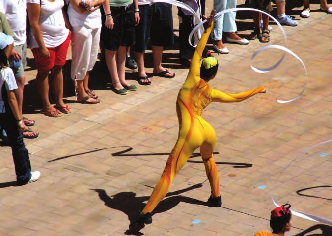
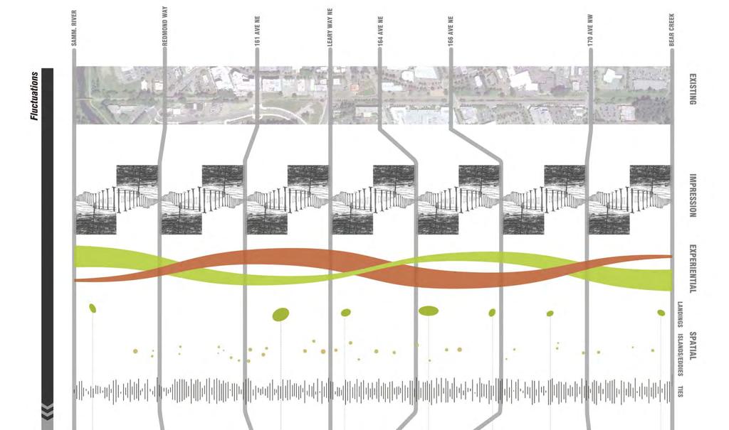
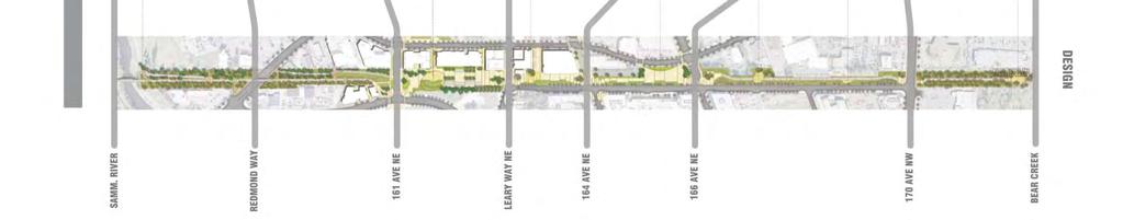
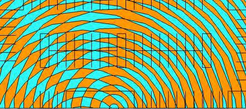
6 Redmond Central Connector Master Plan design framework fluctuations Through the master plan process, two powerful juxtapositions about Redmond emerged, one physical and one cultural. The master plan embraces the ever changing fluctuation of these juxtaposed conditions. strengthening redmond as... An increasingly urban community A city strongly connected to nature A community rooted in history A forward-looking city shaping the world a fluctuation is: a state of ongoing change a wave-like motion a critical combination of events the motion of fluid, usually water, when collected in an artificial or natural cavity This image is an exploration by Perri Lynch, the master plan s artist, of the idea of fluctuations, which greatly influenced the design for the Redmond Connector. 24


7 design framework 25


8 Redmond Central Connector Master Plan design framework experiential fluctuations These fluctuations give form to the corridor through the character and experiential quality of elements throughout the corridor, predominately through the fluctuations between Redmond s character as both natural and urban, and a small town yet forward-looking and shaping the world. sammamish river downtown bear creek 28


9 Redmond Central Connector Master Plan design framework spatial fluctuations Fluctuations also give form to the corridor as physical elements. The design framework consists of a vocabulary of features and spaces that collectively make up the Connector. Although each feature serves a practical function for ensuring a safe, interesting trail experience, their composition and considerations for integrated art express the character of Redmond and contribute to the creation of the corridor as something more than just a trail. landings islands & eddies ties 30


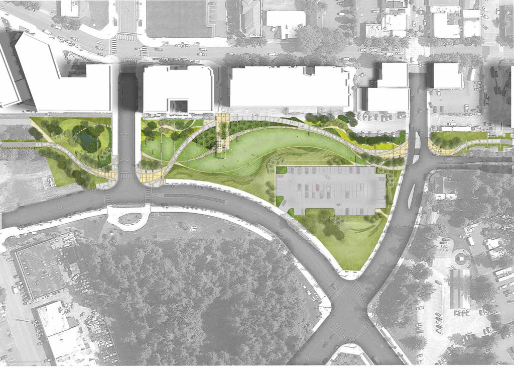
10 landings Landings are major events along the Connector, and contained within the corridor. These spaces are infused with integrated art to produce a dramatic aesthetic when design framework seen from afar and a strong experience from within, drawing people to the corridor and encouraging them to gather and linger. The spaces are typically located in midblock locations and aligned with existing or planned street-end connections with Cleveland Street. Landings may include sculptural landscapes of earthworks, canopies, lighting features, and water features to create signature moments and punctuated points of interest and connectivity along the corridor. Each landing is a uniquely different experience that is meaningful and engaging, yet when experienced and considered as a collective whole, provides a greater understanding of Redmond s unique social and environmental character. 31


11 Redmond Central Connector Master Plan design framework islands & eddies Islands and eddies are secondary elements and events along the Connector, complementing but not competing with landings, providing small spaces that add visual and experiential interest. Recognizing how the flow of people along the corridor is inherently linear, islands and eddies provide relief from that flow as places for pause and escape. Islands could include landscape, site furniture, art, fountains, canopies, pavilions and more. Eddies are inseparably tied to islands, places where the flow of people in the corridor slows and gathering naturally occurs and is supported with seating and other discoveries that enrich the space. 32


12 ties Just as railroad ties connect two separate rails into a functioning whole, the ties in the Connector are linear design elements that create physical and visual connections across the corridor to produce a more cohesive, functioning corridor that is woven into the City s urban design framework fabric. The ties are expressed in a number of ways to serve a variety of functions. They may be flush, extruded or elevated. The ties are rhythmic elements that provide the visual cues and physical space necessary for trail and park users to intuitively slow down and respond to the changes and options that are present along the trail, such as approaching landings and intersections. 33
13

14 Raingarden Ties Signals Braided Trails Salvaged Rail Cordourory Performance Berm Sky Painting
Redmond Central Connector
 Redmond Central Connector Redmond Central Master Connector Plan Master Plan Arts Commission Master Plan Development March 10, 2011 By Carolyn Hope, Senior Planner Guy Michaelsen Dave Knight The Berger
SQUAMISH 2010 AND BEYOND COMMUNITY VISION
 Our plan has been imagined and created to be both pragmatic and visionary. At the core of the strategy is a consideration of the highway s role and its impact on the community. First and foremost in creating
V. Gateways GATEWAYS / V-1
 V. GATEWAYS / V-1 Many of Chesapeake s gateways are located on highways and call for bold and attractive designs that motorists can understand, appreciate, and enjoy. can also take the form of natural
Table of Contents. Elm Avenue Improvement Plan City of Waco, Texas. Introduction 1. Existing Context 1 Figure 1 2.
 Table of Contents Introduction 1 Existing Context 1 Figure 1 2 Plan Guidelines 3 Future Urban Form 4 The West-End 4 Main Street 6 The East-End 7 Figure 2 9 Public Improvement Recommendations 7 General
Public Art Plan. We have elected to submit Public Art Plans before or concurrently with the CSP Submittal per the FDP Manual
 Public Art Plan The intent of the Horizon Uptown Public Arts Program is to create great places that engage the community and leverage the neighborhood development and economic vitality. The Horizon Uptown
Chapter 15. Public Art Guidelines 15.2 GENERAL DESIGN OBJECTIVES 15.1 INTRODUCTION AND PURPOSE 15.3 PUBLIC ART GUIDELINES
 Chapter 15 Public Art Guidelines 15.1 INTRODUCTION AND PURPOSE Public art contributes significantly to the public identity of a place. Public art can stimulate creativity, imagination and add a unique
97 Lea Bridge Road, Leyton, E10 7QL London Borough of Waltham Forest December 2015
 97 Lea Bridge Road, Leyton, E10 7QL London Borough of Waltham Forest December 2015 Public Realm and Landscape Proposals LEA BRIDGE ROAD, WALTHAMSTOW Public Realm & Landscape Proposals BDP(90)RPT001 December
Include new ideas developed during this planning process
 Pull ideas from several previously adopted plans Noblesville Alternative Transportation Plan (2015) PLANoblesville (2016) Noblesville Downtown Parking Study (2016) Cultural Arts Blueprint (2016) Alley
HE VISION. Building a Better Connected Place
 HE VISION Building a Better Connected Place WALK INTO THE FUTURE. Life in Cranberry, 2030 Here s what our residents told us they wanted to see in their community by 2030: The Cranberry of 2030 is a place
A Vibrant Downtown. Chapter 5 Cary Public Art Opportunities 31
 A Vibrant Downtown Cary s vision for Downtown is a unique, vibrant, dynamic, pedestrian friendly location; a regional destination and a place to live, work, and recreate, according to the 2001 Town Center
GUIDING PRINCIPLES IN THIS CHAPTER
 GUIDING PRINCIPLES The guiding principles and design concepts in this chapter work together with the Chapel Hill 2020 Comprehensive Plan to support new public places that can be enjoyed by all while also
WELLINGTON STREET WEST COMMUNITY DESIGN PLAN
 36 3.CDP POLICIES 37 Wellington Street West CDP Vision Statement 38 3.1 Introduction 3.1.1 Purpose The development of buildings and public spaces is influenced by a variety of factors over time. City of
Lehigh Acres Land Development Regulations Community Planning Project
 Lehigh Acres Land Development Regulations Planning Effort Summary In July, 2010 Commissioner Frank Mann invited the Lehigh Acres community to start discussing how to achieve their recently adopted community
4.9 Mendocino Avenue Corridor Plan Design Guidelines
 4.9 Mendocino Avenue Corridor Plan Design Guidelines The Mendocino Avenue Corridor Plan addresses the area between College Avenue and Steele Lane. Mendocino Avenue is a busy arterial that runs parallel
The Vision. Photo provided by The Minervini Group. 46 Vision, Objectives & Strategies
 Vision, Objectives & Strategies The is the public framework and guide for future development of the Grand Traverse Commons. The establishes public polices for infrastructure, the preservation of natural
City of Farmington. Downtown Plan. Amendment to the 1998 Master Plan Adopted October 11, 2004
 City of Farmington Amendment to the 1998 Master Plan Adopted October 11, 2004 Introduction Planning Background 1 Scope and Components of the Plan Amendment 2 Concept Introduction 3 Plan Concepts 3 Conceptual
Mid-Rise Buildings on Toronto s Avenues Responding to the Public Realm Andrea Oppedisano, City of Toronto
 Mid-Rise Buildings on Toronto s Avenues Responding to the Public Realm Andrea, City of Toronto Introduction The Avenues and Mid-Rise Buildings Study explores opportunities to encourage a built form that
FUNDAMENTAL BUILDING BLOCKS
 FUNDAMENTAL BUILDING BLOCKS THE WEB OF GIBSONS - EXISTING Lacks Community Structure and Support Circulation, surface water flow and buildings are disjointed from the community Social neighbourhoods are
Small Area Plan. South Gateway
 Small Area Plan Adopted May 12, 2008 South Gateway Purpose. The South Gateway Small Area Plan defines the City s expectations for the future of the southern entrance to the City at Interstate 85 and Highway
VILLAGE OF SKOKIE Design Guidelines for Mixed-Use Districts NX Neighborhood Mixed-Use TX Transit Mixed-Use CX Core Mixed-Use
 VILLAGE OF SKOKIE Design Guidelines for Mixed-Use Districts NX Neighborhood Mixed-Use TX Transit Mixed-Use CX Core Mixed-Use TABLE OF CONTENTS CHAPTER 1 SITE DESIGN Purpose 1 CHAPTER 2 SITE DESIGN Streetscape
CHAPTER 7: VISION AND ACTION STATEMENTS. Noble 2025 Vision Statement
 CHAPTER 7: VISION AND ACTION STATEMENTS This chapter presents the vision, policy and action statements that transform the comprehensive planning study, an analysis of Noble s past, future trends and community
EXTERlOR DESlGN LANGUAGE. Exterior Design Language PAGE 1 OF 27
 EXTERlOR DESlGN LANGUAGE Exterior Design Language PAGE 1 OF 27 INTRODUCTION EXTERIOR DESIGN LANGUAGE What is this document and who is it for? Exterior Design Language is a supplement to the original Design
UNION STUDIO Greater Kennedy Plaza!
 April May 2013 UNION STUDIO Greater Kennedy Plaza! It s time: Providence s civic plaza and transit hub is re-imagined as a vibrant urban gathering place 1 Kennedy Plaza Reborn THE TEAM Client: The City
4- PA - LD - LIVELY DOWNTOWN. LD - Background
 4- PA - LD - LIVELY DOWNTOWN LD - Background The downtown has been the service centre for the community since the city s inception and the area continues to supply people with their personal services,
Town Center (part of the Comprehensive Plan)
") Town Center (part of the Comprehensive Plan) Mercer Island Town Center Looking North (2014) In 1994, a year-long process culminated in a set of design guidelines and code requirements for the Town Center
Town Center (part of the Comprehensive Plan) Mercer Island Town Center Looking North (2014) In 1994, a year-long process culminated in a set of design guidelines and code requirements for the Town Center
Route 347. New York State Department of Transportation Region 10, Long Island. THE GREENING of ROUTE 347
 The GREENING of Route 347 The Greening of Route 347 The Greening of Route 347: History 3 The Greening of Route 347 4 The Greening of Route 347 5 The Greening of Route 347 Smith Haven Mall 6 The Greening
Workshop Purpose Workshop Agenda Discussion Group Questions
 Library Garden Co-Discovery Workshop Group Discussion Notes September 30, 2015 Workshop Purpose Building on the Library Garden Values + Revitalization Study and project Design Brief, establish a common
Welcome. Community Consultation Meeting November 28, Review and discuss the Bathurst Quay Neighbourhood Plan Framework
 Welcome Community Consultation Meeting November 28, 2016 Why Are We Here Today? Review and discuss the Bathurst Quay Neighbourhood Plan Framework Review and discuss an Action Plan for Implementation Next
10.0 Open Space and Public Realm
 10.0 Open Space and Public Realm 10.0 Open Space and Public Realm The Public Open Space System is comprised of: outdoor spaces available for public use that are either publicly owned (e.g., parks and
Corridor Vision. 1Pursue Minnehaha-Hiawatha Community Works Project. Mission of Hennepin County Community Works Program
 1Pursue Minnehaha-Hiawatha Community Works Project Minnehaha-Hiawatha Community Works is a project within the Hennepin Community Works (HCW) program. The mission of the HCW program is to enhance how the
ROSENTHAL CARPARK LIFE BETWEEN BUILDINGS IN LANE COVE
 south square Life between buildings includes all the very different activities people engage in when they use common city space; purposeful walks from place to place, promenades, short stops, longer stays,
CAMPUS MASTER PLAN UPDATE
 13 April 2016 CAMPUS MASTER PLAN UPDATE Focus Group Landscape AGENDA What We Heard Review of Campus Observations & Analysis Campus Framework & Open Space Network Table-Top Exercise Landscape Guideline
The Five Components of the McLoughlin Area Plan
 The Five Components of the McLoughlin Area Plan This documents contains the complete language of the five components of the McLoughlin Area Plan: The Vision Statement The Values The Guiding Principles
BE PART OF THE CHANGE life works here.
 BE PART OF THE CHANGE life works here. A NEW DESTINATION FOR URBAN LIVING IN CALGARY Experience UNIVERSITY DISTRICT. A new quality of life community that will change the way you experience the city. Architecturally
Ivywild On The Creek PRELIMINARY CREEK DISTRICT MASTER PLAN
 Ivywild On The Creek PRELIMINARY CREEK DISTRICT MASTER PLAN Introduction: Rejuvenating an extraordinary Creekside neighborhood THE CREEKSIDE DISTRICT The Ivywild On The Creek Neighborhood District Master
Policies and Code Intent Sections Related to Town Center
 Policies and Code Intent Sections Related to Town Center The Town Center Vision is scattered throughout the Comprehensive Plan, development code and the 1994 Town Center Plan. What follows are sections
TOWN COUNCIL / PLANNING COMMISSION
 Workshop #3 TOWN COUNCIL / PLANNING COMMISSION January 20, 2011 Consultant Team In Attendance Tonight BMS Design Group Nevada City and San Francisco Michael Smiley, AICP, ASLA Partner-in-Charge Nancy L.
Vision Plan Kickoff Meeting Summary Report
 Vision Plan Kickoff Meeting Summary Report October 2018 The Vision Plan With the redevelopment of the Amtrak Property, Penn Station Partners (PSP) seeks to build on the creative talent and entrepreneurial
CHAPTER 5: GUIDING PRINCIPLES
 CHAPTER 5: GUIDING PRINCIPLES The following 10 principles were developed based on public consultation, planning policy and the background analysis conducted during Phase 1. The Guiding Principles significantly
section five BEAUTIFICATION PLAN
 section five BEAUTIFICATION PLAN BEAUTIFICATION PLAN Section Five Beautification Plan The goal of the Beautification Plan is to improve the Route 8-Sunnyland Corridor in terms of aesthetics and to create
DOWNTOWN NORFOLK COUNCIL ACTION PLAN. Strategic Initiatives Focus Area Objectives. Departmental Focus Area Key Objectives
 DOWNTOWN NORFOLK COUNCIL ACTION PLAN FY18 Strategic Initiatives Focus Area Objectives Departmental Focus Area Key Objectives STRATEGIC INITIATIVES FOCUS AREA OBJECTIVE #1: NURTURE A VIBRANT URBAN ENVIRONMENT
Dyersville Downtown Plan. Open House October 24, 2017
 Dyersville Downtown Plan Open House October 24, 2017 What is a Comprehensive Plan? - Vision - Guidance for decisions - Basis for regulations What is a Downtown Plan? - Understand priorities - Identify
QUESTION 8: What are your Public Realm priorities for implementation? What would you like to see happen first? TELL US WHAT YOU THINK
 Public Realm Plan How will the Public Realm Plan be implemented? The Public Realm Plan document will set out a vision for the next 30 years. Over time, Plan elements and aspects can be implemented as opportunities
Public Art Guidelines And Public Art Donation Program
 Public Art Guidelines And Public Art Donation Program Adopted by City Council Resolution No. 3787 October 12, 2004 Ordinance No. 557 October 26, 2004 Amended by City Council Resolution No. 4411 November
PUBLIC ART CALL LIONS GATE COMMUNITY CENTRE. For Expressions of Interest Submission Deadline: March 18, 2018 Project Value: $85,000(inclusive)
") LIONS GATE COMMUNITY CENTRE PUBLIC ART CALL For Expressions of Interest Submission Deadline: March 18, 2018 Project Value: $85,000(inclusive) LGCC EOI 1 LIONS GATE COMMUNITY CENTRE (LGCC) PUBLIC ART CALL
LIONS GATE COMMUNITY CENTRE PUBLIC ART CALL For Expressions of Interest Submission Deadline: March 18, 2018 Project Value: $85,000(inclusive) LGCC EOI 1 LIONS GATE COMMUNITY CENTRE (LGCC) PUBLIC ART CALL
EXISTING COMPREHENSIVE PLAN
 EXISTING COMPREHENSIVE PLAN Town Center Land Use Element: V. LAND USE POLICIES Town Center Mercer Island's business district vision as described in "Your Mercer Island Citizen-Designed Downtown" was an
Planning Board Hearing October 20th, 2016
 Planning Board Hearing October 0th, 06 Developer: Real Estate Management & Leasing: Architect: Transportation Engineers: Landscape Architect: Civil Engineer: THE ARSENAL PROJECT Planning Board AGENDA Introduction
1 Welcome! UBC Okanagan Master Plan Update - Open House
 1 Welcome! UBC Okanagan Master Plan Update - Open House UBC is updating the Master Plan for the Okanagan Campus. The purpose of today s Open House is to: Present the draft 2015 Master Plan Answer any questions
Bus Rapid Transit Backgrounder. December 2016
 Bus Rapid Transit Backgrounder December 2016 Background The City of London is completing the second stage of Shift, its public transit planning exercise. Shift, focuses on rapid transit, along with vehicular
Urban Design Manual PLANNING AROUND RAPID TRANSIT STATIONS (PARTS) Introduction. Station Study Areas
 Introduction. Station Study Areas") 111111 PLANNING AROUND RAPID TRANSIT STATIONS (PARTS) Introduction The ION rapid transit system will link Waterloo, Kitchener and Cambridge through a central transit corridor (CTC). There are a number
111111 PLANNING AROUND RAPID TRANSIT STATIONS (PARTS) Introduction The ION rapid transit system will link Waterloo, Kitchener and Cambridge through a central transit corridor (CTC). There are a number
A new park will be delivered as part of the Elephant Park regeneration.
 A new park will be delivered as part of the Elephant Park regeneration. The exhibition boards presented here introduce the first phase of the new park that is scheduled to open in spring 2017 that has
UNIVERSITY TOWN NEIGHBOURHOODS 5.2 ECO-CORRIDOR MELBOURNE CAMPUS MASTER PLAN 2014
 5.2 ECO-CORRIDOR 37 ECO-CORRIDOR EXISTING CONDITIONS & VISION NEIGHBOURHOOD VISION Investment in the Eco-corridor Neighbourhood will signify the University s commitment to supporting local ecology and
ANCHOR TO ANCHOR. Rescale the street to create an iconic boulevard.
 ANCHOR TO ANCHOR Rescale the street to create an iconic boulevard. UR NE ER UV GO NE LA OBJECTIVES 1. Maintain appropriate traffic flow and prioritize commercial curb access 2. Mark gateways at the street
PLAN ELEMENTS WORKSHOP. April 5, 2016
 PLAN ELEMENTS WORKSHOP April 5, 2016 needs more housing. But there is no one-size fits-all solution. Every neighborhood has its own character. In some places, density is not only appropriate it is badly
the village at market creek
 the village at market creek executive summary october 2012 i ii introduction The Village at Market Creek is primed to grow into one of San Diego s most lively, multi-cultural arts destinations. Our community
Willamette Falls Downtown District Policies and Design Guidelines
 Willamette Falls Downtown District Policies and Design Guidelines The District Policies and Design Guidelines are mandatory for future development within the Willamette Falls Downtown District, and will
CHAPTER 6: Community Design and Appearance
 AGLE AREA COMMUNITY Plan CHAPTER 6 CHAPTER 6: Community Design and Appearance Community Design and Appearance How a community is designed and what a community looks like are attributes fundamental to the
3.1 community vision. 3.3 required plan elements
 Chapter 3 Community Form 3.1 community vision 3.2 Parks & landscaping concepts 3.3 required plan elements D R A F T 20 Community Form Chapter 3 3.0 Community form 3.1 community vision The Specific Plan
Urban Design 9Identity
 Urban Design 9Identity URBAN DESIGN IDENTITY Urban design is about connecting people to their places through the built environment, nature, and overall urban form. Done well, it creates a memorable space
hermitage town center
 hermitage town center A Community Vision prepared by Strada for The City of Hermitage and The Mercer County Regional Planning Commission January 2007 table of contents introduction 3 design principles
UTSC SECONDARY PLAN COMMUNITY OPEN HOUSE
 WELCOME TO THE UTSC SECONDARY PLAN COMMUNITY OPEN HOUSE 1 Welcome to the first Community Open House for the UTSC Secondary Plan. Hosted by the University of Toronto Scarborough (UTSC), the following panels
Downtown Papillion. Concepts for the Enhancement and Growth of Papillion s Traditional Town Center
 Downtown Papillion Concepts for the Enhancement and Growth of Papillion s Traditional Town Center Developed for the City of Papillion by RDG Planning & Design T raditional downtown districts occupy a particular
Bourne Downtown Site Planning
 Prepared for: The Town of Bourne, MA In Cooperation with: Bourne Financial Development Corporation Prepared by:, Inc. June 24, 2009 Table of Contents Introduction and Summary... 1 Site Existing Conditions...
JULIA M. CARSON TRANSIT CENTER
 CATEGORY New Construction (Project Cost Greater Than $1 Million) PROJECT TYPE Public Transportation Facility ADDRESS 201 East Washington Street, Indianapolis, Indiana, 46202 COMPLETION June 2016 As the
Potential Green Infrastructure Strategies May 6, 2015 Workshop
 Potential Green Infrastructure Strategies May 6, 2015 Workshop Background The City of Cortland is developing the Tioughnioga Urban Headwaters Green Infrastructure Action Plan with funding from the National
Phase 1 : Understanding the Campus Context. Phase 2 : APPROACHES - Alternates & Preferred Plan
 Introduction MASTER PLAN PURPOSE WHY A CAMPUS MASTER PLAN? The purpose of the Master Plan at the University of Illinois at Chicago is to translate UIC s strategic goals and objectives into a compelling
public review draft Key objectives for this chapter are:
 5 - parks & open space Providing a rich collection of outdoor places for informal gathering and recreation, as well as planned promotional activities and community events, is a key concept for Midtown.
4. INDUSTRIAL 53 CASTLE ROCK DESIGN
 4. INDUSTRIAL 53 CASTLE ROCK DESIGN CASTLE ROCK DESIGN 54 4. INDUSTRIAL Overview Well-designed and attractive industrial centers are the product of blending economic realities with both functional and
BUSINESS DISTRICT DESIGN GUIDELINES
 Des Plaines, Illinois Prepared for the City of Des Plaines by: The Lakota Group Laurie Marston, AICP March 2005 Section 5: Streetscape Elements Business District Design Guidelines STREETSCAPE ELEMENTS
THE NEIGHBORHOOD TODAY
 THE NEIGHBORHOOD TODAY CORE AREA VISION How are we Good Urbanism A Site s DNA thinking about Elements of great Unique elements urban communities embedded in a place the site and design? ELEMENTS LIKE:
4 Park Planning and Design
 4 Park Planning and Design Park Constellations Elliot Gateway/Mills Loring North Loop Commons Twins Minneapolis Park & Recreation Board Downtown Service Area Master Plan 4-1 PROJECT APPROACH REFERENCE
University of Denver Land Use Plan Update I. Executive Summary
 Executive Summary The task of developing a Land Use Plan for the University of Denver has been an exciting collaborative process that engaged a variety of interested people, including members of the University
The University District envisions, in its neighborhood
 Envisioning the University District Link Light Rail in Seattle s neighborhoods CIY OF SEALE CONCEP-LEVEL SAION AREA PLANNING RECOMMENDAION RESOLUION # 30165 EXHIBI L Vision 08.2000 he University District
9IMPLEMENTATION AND PHASING
 9IMPLEMENTATION AND PHASING Purpose A key objective of the Railyard Master Plan is the integration of the public and private realm to provide a network of places that connect to and complement Commercial
Economy Vision Statements: Social Wellbeing Vision Statements: Natural Environment Vision Statements:
 Economy Vision Statements: 1. Our business environment makes us a region of choice for new employers as we encourage entrepreneurship and have a vibrant, diversified and resilient regional economy. 2.
MARINA MARKET & WATERFRONT DEVELOPMENT STUDY PORT ARANSAS, TEXAS
 MARINA MARKET & WATERFRONT DEVELOPMENT STUDY PORT ARANSAS, TEXAS FEBRUARY 2015 PRESENTATION OUTLINE 1 2 3 4 5 6 7 REGIONAL POSITIONING SITE IMPRESSIONS PLANNING & DESIGN PRINCIPLES EXISTING IMPROVEMENTS
NEIGHBORHOOD 3: UNIVERSITY EDGE
 NEIGHBORHOOD 3: UNIVERSITY EDGE Aerial View of North Indiana Avenue EXISTING CHARACTER The University Edge neighborhood represents the primary town/gown interface between the campus and the city of Bloomington,
Parks Master Plan Implementation: Phase I Waterfront Use and Design REPORT #: September 7, 2016 File #
 0 'O DI Lan-171-14 1 - THE CORPORATION OF THE TOWN OF COBOURG..,. STAFF REPORT TO: FROM: Mayor and Members of Council Dean A. Hustwick, Director of Recreation and Culture DATE OF MEETING: Committee of
Parks, Open Space and Trails
 Introduction Parks have often been referred as the lungs of our cities, cleansing the air of pollutants and particulate matter. Parks are also gathering places for families and community. They offer spaces
City of Tacoma Planning and Development Services
 Agenda Item E-1 City of Tacoma Planning and Development Services To: Planning Commission From: Elliott Barnett, Planning Services Division Subject: Tacoma Mall Regional Center Subarea Plan and EIS Meeting
Preliminary Plan Framework: Vision and Goals
 Preliminary Plan Framework: Vision and Goals Draft: May 2015 Introduction Since the Town of Milliken s comprehensive plan was last updated in 2010, the community was heavily impacted by the 2013 flood,
Visioning Statement and Guiding Principles
 Visioning Statement and Guiding Principles Planning for the Future The General Plan The General Plan represents Woodland's shared vision of the future and defines a path to lead the community toward its
Reimagining Arnolds Creek. Community engagement report. May 2018
 Reimagining Arnolds Creek Community engagement report May 2018 Melbourne Water is owned by the Victorian Government. We manage Melbourne s water supply catchments, remove and treat most of Melbourne s
RE-Imagining the Downtown Colorado Springs Master Plan
 RE-Imagining the Downtown Colorado Springs Master Plan 2016 APA Colorado State Conference October 25, 2016 Overview 8:00 Welcome, Introductions, and Overview 8:15 Downtown s Planning History 8:30 A Market
City of Redlands Architectural Guidelines for Non-Residential Development
 14. Building articulation shall be included in the design of building, in order to create a formal entry statement. Avoid this Do this Page 11 15. Give special attention to creating pedestrian scale and
DOWNTOWN PHOENIX URBAN FORM PROJECT
 DOWNTOWN PHOENIX URBAN FORM PROJECT NACAA Fall Meeting October 22, 2008 Dean Brennan, FAICP Principal Planner ARIZONA GHG GROWTH RATE 1990-2040 Percent Source: AZ Climate Change Action Plan 160 140 120
 Community Workshop #2 December 4, 2014 Team Tonight s Agenda 6:00 pm Welcome! 6:05 pm The Future of Downtown Tustin Ideas, Strategies and Recommendations 6:35 pm Questions and Comments 6:50 pm Open
Chapter 1: Introduction
 Chapter 1: Introduction The Penn Avenue Community Works Corridor Vision and Implementation Framework presents an integrated communitybased vision and a coordinated, long-term implementation framework for
TEAM INPUT SUMMARY. Postcard Image?
 DOWNTOWN MAULDIN TEAM PUBLIC INPUT TEAM INPUT SUMMARY Postcard Image? A nice neighborhood The main city center with government buildings Mauldin entry sign, high school, Cultural Center, Sunset Park, Hall
greenprint midtown SUSTAINABILITY ACTION PLAN 2012
 greenprint midtown SUSTAINABILITY ACTION PLAN 2012 MIDTOWN ALLIANCE SOUTHFACE ENERGY INSTITUTE RENAISSANCE PLANNING GROUP SUSTAINABLE ATLANTA PERKINS+WILL 2 GREENPRINT MIDTOWN 1. Introduction Sustainability
TRANSIT-ORIENTED DEVELOPMENT POLICY DRAFT. City Planning and Development Department Kansas City, Missouri
 TRANSIT-ORIENTED DEVELOPMENT POLICY DRAFT City Planning and Development Department Kansas City, Missouri What is Transit Oriented Development (TOD)? Development that focuses land uses around a transit
Downtown Dubuque...it s a great time.
 Downtown Dubuque...it s a great time. Your timing could not be better to invest in Downtown. With hundreds of millions in public and private investment occurring on the City s downtown waterfront, millions
The transportation system in a community is an
 7 TRANSPORTATION The transportation system in a community is an important factor contributing to the quality of life of the residents. Without a sound transportation system to bring both goods and patrons
THEMES, VISION, + PRINCIPLES
 CHAPTER 2: THEMES, VISION, + PRINCIPLES This page intentionally left blank. 20 VISION DRAFT AUGUST 2018 2 2 THEMES, VISION, + GUIDING PRINCIPLES The Key Themes, Vision, and Guiding Principles presented
Grantsburg Community Design Team (CDT)
") Grantsburg Community Design Team (CDT) Summary Report Overview On April 10-13, 2014, a team of (19) volunteer planners, design professionals, and community development educators volunteered their time
Grantsburg Community Design Team (CDT) Summary Report Overview On April 10-13, 2014, a team of (19) volunteer planners, design professionals, and community development educators volunteered their time
DRAFT ROOSEVELT ROAD. District Recommendations. Figure 5.23 The Roosevelt Road Corridor
 CHAPTER 5 Figure 5.23 The Road Corridor Road will develop as a mixed-use corridor, emphasizing regional retail, west of the river and mixed-use development east of the river. KEY RECOMMENDATIONS 1. High
Museum Selections.
 Museum Selections Corning Museum of Glass : Contemporary Glass Galleries Corning Museum of Glass : Expansion Study Projects : 2003-2007 New South Field Contemporary Glass Galleries The New South Field
Urban Greening Plan Proposed Policies and Programs Matrix Existing City Plans and Goals Programs Policies Notes/Comments
 Urban Greening Plan Circulation Plan for Bicyclists and Pedestrians (2007) 1.1 - Develop a coordinated Trail Maintenance Volunteer Program that identifies funding and leverages community efforts and partnerships
Sustainability, Health, Safety, Recreation & Open Space Working Group August 3, 2017
 Sustainability, Health, Safety, Recreation & Open Space Working Group August 3, 2017 DOWNTOWN OAKLAND SPECIFIC PLAN WELCOME Sustainability, Health, Safety, Recreation & Open Space Working Group Social
1. Avoid extensive blank walls that would detract from the experience and appearance of an active streetscape.
 08 ARCHITECTURAL DETAIL Once a building s massing and street wall have been defined, architectural details, including façade variation, materials and window treatment, shape a building s visual identity.