West Ocala Vision & Community Plan City Council Work Session. Presented by West Ocala Community Plan Steering Committee
|
|
|
- Jordan Gilmore
- 5 years ago
- Views:
Transcription

1 West Ocala Vision & Community Plan City Council Work Session Presented by West Ocala Community Plan Steering Committee November 29,2011


2 Ocala 2035 Vision West Ocala Community Vision & Master Plan West Ocala Community Future Land Use & Comprehensive Plan Policies included in EAR Amendments Zoning / Form Based Code Corridor Overlay Design Guidelines CRA Plan


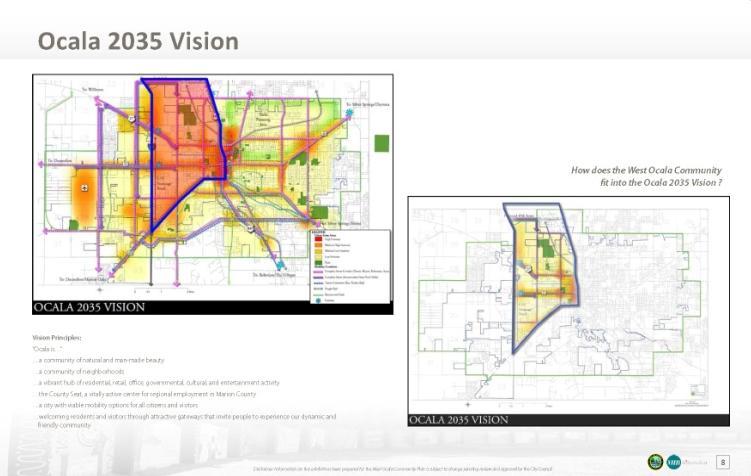
3 The West Ocala Vision & Community Plan is consistent with the Ocala 2035 Vision.
4 West Ocala Community s 2035 Vision Principles West Ocala is; a diverse, dynamic, friendly and safe community a community of walkable and connected neighborhoods a vibrant community of residential, retail, business, governmental, cultural, educational and entertainment activity centers a community with a variety of mobility options for all citizens and visitors a community with attractive gateways and tree lined streets a community of connected parks and neighborhoods a healthy, diverse and caring community of neighbors and neighborhoods who watch for and care for one another from infant to aged, generation to generation.
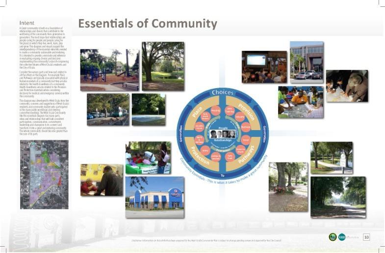
5 Purpose for the West Ocala Community Plan To establish a foundation for decisions for tomorrow through 2035 To establish community priorities To describe what the Community wants to look like To build community participation, consensus and support for improving the collective futures of West Ocala s residents Preserving the History and Culture of West Ocala as part of a diverse and vibrant Community To reconnect people, neighborhoods and community
6 Major Organizing Components Principles Purpose, Public Participation & History Employment Centers Neighborhoods 6 Named Mixed Use Districts Croskey Commons Main Street Mixed Use District Pine Oak Square Main Street Mixed Use District North Gate Way Main Street Mixed Use District Cotton Park Crossing Main Street Mixed Use District College Park Mixed Use District Pine Avenue Downtown District Re-connected (Names as recommended by Steering Committee can be changed) Gateways & Corridors Community Essentials Recommendations Desired Outcomes


7 Employment Center District Intent: Promote a regionally-important and vibrant hub for business, enterprise, research and development and employment activities Form: development and re-development should promote excellence in the design and construction of buildings, environmental systems, outdoor spaces, transportation facilities, way finding and streetscapes; low and mid rise buildings on horizontally mixed use sites support and protect the vitality and quality of life in adjacent properties and neighborhoods. Uses: Public, Office, Business, Wholesale, Industrial, Professional Service, Retail, Workforce Housing on a case by case basis


8 Neighborhoods District Intent: a walkable urban form expressed as identifiable neighborhoods where the predominant land use is residential The history, character, and connectivity of existing neighborhoods should be considered in new development and redevelopment proposals. Form: Buildings are generally low and mid rise in character. Housing types: predominately small lot single family detached homes, attached homes like row houses or townhomes garden style multifamily buildings.


9 Neighborhoods District continued Public parks: Located within walking distance of the majority of housing units within neighborhoods Parks and collector streets should form a connected network of sidewalks and multi-use paths/trails. Uses: the predominant land use is residential neighborhood supporting secondary uses may be permitted but should be limited in number, and subject to compatibility review for architectural character, building scale and intensity. secondary uses may include; public, office, and health care, education/recreation/social, service and retail uses.


10 Who has helped shape this Plan? RESIDENTS OF WEST OCALA 1 West Ocala Town Hall Meeting 3 Community-wide Workshops COMMUNITY GROUPS»Barbara Washington Senior Activity Center»City of Ocala Enterprise Zone»Family Resource Center»Governor s West Ocala Neighborhood Revitalization Council»Howard Middle School Students»Ministerial Alliance»Ocala Housing Authority»Marion County NAACP»Neighborhood Citizens of Northwest Ocala»Phoenix Rising»Poinciana Heights Task Force»Buddy Martin Radio Show WEST OCALA COMMUNITY PLAN STEERING COMMITTEE multiple Meetings The History of prior Generations


11 West Ocala Vision & Community Plan Steering Committee: Narvella Haynes, Chair Elton Bellamy Ire Bethea Susie Debose Clara Eckles Wanda Fulton Jerome Johnson Glenda Jones Ruth Reed Roosevelt Rimes, Jr. Mary Williams


12 Pine Avenue Corridor Downtown District Reconnected Intent: Extend and reconnect the Downtown District into West Ocala within a regionallyimportant and vibrant hub of activity that allows residents to live, work, shop, play and grow within a highly walkable and connected urban core Form: Buildings are typically 1-4 stories located close to the street US 441/Pine Ave: Narrow from six to 4 lanes Provide safe and comfortable pedestrian sidewalks and crossings to downtown uses Variety of uses mixed horizontally and vertically Architectural review for compatibility with residential areas Uses: residential, public, office, and health care, education/recreation/social, service and retail uses.


13 Croskey Commons Main Street Mixed Use District Intent: promote a compact and walkable urban form that serves as the historical focal point and gathering place for recreation, civic, social and cultural activities within the West Ocala Community. Form: a walkable main street with on street parking and enhanced pedestrian crossing on MLK Avenue Creation of a Gateway Feature on SR 40 Building Height: 1-4 stories Architectural review for compatibility with residential areas Uses: residential, office, commercial, public, recreation & open space, institutional. MLK Park, the Hampton Center, a library, a new recreation center, community gardens and a Farmers Market should become key components of this district


14 North Gate Way Main Street Mixed Use District Intent: promote a gathering place for civic, social, and commercial activities in the northwest quadrant of the West Ocala Community and supporting the Ocala Marion County Commerce Park. Form: a walkable main street with on street parking and with access to multi-modal transportation. This district is characterized by buildings one (1) to four (4) stories in height and may contain more than one use. The emphasis will be on building form and orientation to the street and public spaces, rather than type of use Uses: Residential, Office, Commercial, Public, Recreation Potential uses that have been discussed include a grocery store and the development of a transit station


15 Pine Oak Square Main Street Mixed Use District Intent: promote a gathering place for civic, social, and commercial activities in the northeast quadrant of the West Ocala Community. Form: a walkable main street with on street parking and with access to multi-modal transportation. This district is characterized by buildings one (1) to four (4) stories in height and may contain more than one use. The emphasis will be on building form and orientation to the street and public spaces, rather than type of use Uses: Residential, Office, Commercial, Public, Recreation Potential uses that have been discussed include a conference center, green industry, community garden and a transit station


16 Cotton Park Crossing Main Street Mixed Use District Intent: promote a gathering place for civic, social, and commercial activities in the southwest quadrant of the West Ocala Community. Form: a walkable main street with on street parking and with access to multi-modal transportation. This district is characterized by buildings one (1) to four (4) stories in height and may contain more than one use. The emphasis will be on building form and orientation to the street and public spaces, rather than type of use Uses: Residential, Office, Commercial, Public, Recreation Enhanced pedestrian crossing on SW 27 Th Ave, improved connections to surrounding uses and streets, and redevelopment of the SW 10 th street west of SW 27 th Ave as the Main Street are important features of this district.


17 College Park Mixed Use District Intent: promote a gathering place for civic, social, and commercial activities supporting the College of Central Florida and surrounding residential areas.. Form: Building Height: 1-4 stories Architectural review for compatibility with residential areas Uses: residential, office, commercial, public, recreation & open space, institutional. Creation of a gateway feature on SR 200 and 27th Ave., enhanced pedestrian crossing on SW 27th Ave, improved connections to surrounding uses and streets, and to the College are important features of this district.


18 Gateways & Corridors Intent: Build a stronger identity and image as a business ready city and with a high quality of life. Create the types of spaces, features, and amenities that attract and retain employers and employees Promote improvements to the gateways and corridors: Though public and private initiatives that will include physical improvements, adoption of building and site design guidelines and standards, adaptive re-use for buildings and properties providing appropriate transitions to adjacent land uses especially Neighborhoods along designated corridors.
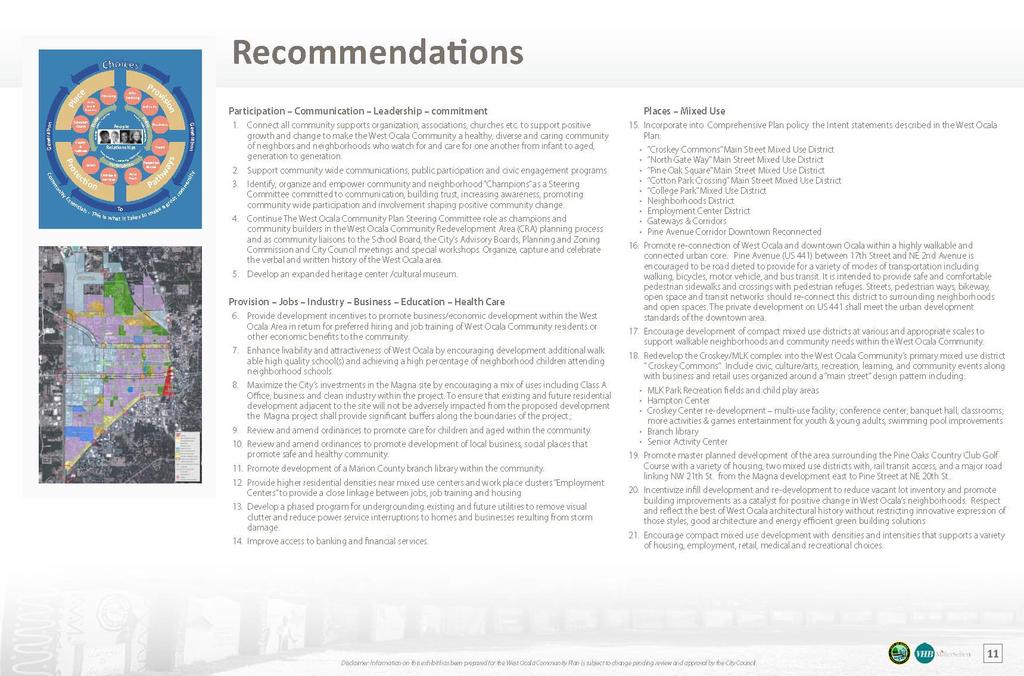
19 Recommendations
20 Recommendations Participation-Communication- Leadership- commitment Connect all community support organizations, associations, churches etc. to support positive growth and change to make the West Ocala Community a healthy, diverse and caring community of neighbors and neighborhoods who watch for and care for one another from infant to aged, generation to generation. Support community wide communications, public participation and civic engagement programs Identify, organize and empower community and neighborhood Champions as a Steering Committee committed to communication, building trust, increasing awareness, promoting community wide participation and involvement shaping positive community change. Continue The West Ocala Community Plan Steering Committee role as champions and community builders in the West Ocala Community Redevelopment Area (CRA) planning process and as community liaisons to the School Board, the City s Advisory Boards, Planning and Zoning Commission and City Council meetings and special workshops. Organize, capture and celebrate the verbal and written history of the West Ocala area. Develop an expanded heritage center /cultural museum.
21 Recommendations Provision- Jobs -Industry Business- Education -Health Care Provide development incentives to promote business/economic development within the West Ocala Area in return for preferred hiring and job training of West Ocala Community residents or other economic benefits to the community. Enhance livability and attractiveness of West Ocala by encouraging development additional walkable high quality school(s) and achieving a high percentage of neighborhood children attending neighborhood schools. Maximize the City s investments in the Magna site by encouraging a mix of uses including Class A Office, business and clean industry within the project. To ensure that existing and future residential development adjacent to the site will not be adversely impacted from the proposed development, the Magna project shall provide significant buffers along the boundaries of the project.
22 Recommendations Provision- Jobs -Industry Business- Education -Health Care, continued: Review and amend ordinances to promote care for children and aged within the community. Review and amend ordinances to promote development of local business, social places that promote safe and healthy community. Promote development of a Marion County branch library within the community. Provide higher residential densities near mixed use centers and work place clusters Employment Centers to provide a close linkage between jobs, job training and housing Develop a phased program for undergrounding existing and future utilities to remove visual clutter and reduce power service interruptions to homes and businesses resulting from storm damage.

23 Recommendations Places Mixed Use Incorporate into Comprehensive Plan policy the Intent statements described in the West Ocala Plan : example Croskey Commons Main Street Mixed Use District Promote re-connection of West Ocala and downtown Ocala within a highly walkable and connected urban core. o Pine Avenue (US 441) between 17th Street and NE 2nd Avenue is encouraged to be road dieted to provide for a variety of modes of transportation including walking, bicycles, motor vehicle, and bus transit. It is intended to provide safe and comfortable pedestrian sidewalks and crossings with pedestrian refuges. Streets, pedestrian ways, bikeway, open space and transit networks should re-connect this district to surrounding neighborhoods and open spaces. The private development on US 441 shall meet the urban development standards of the downtown area. Encourage development of compact mixed use districts at various and appropriate scales to support walkable neighborhoods and community needs within the West Ocala Community.

24 Recommendations Places Mixed Use, continued: Redevelop the Croskey/MLK complex into the West Ocala Community s primary mixed use district Croskey Commons. Include civic, culture/arts, recreation, learning, and community events along with business and retail uses organized around a main street design pattern including: o o o o o MLK Park Recreation fields and child play areas Hampton Center Croskey Center re-development multi-use facility; conference center; banquet hall; classrooms; more activities & games entertainment for youth & young adults, swimming pool improvements Branch library Senior Activity Center Promote master planned development of the area surrounding the Pine Oaks Country Club Golf Course with a variety of housing, two mixed use districts with, rail transit access, and a major road linking NW 21 th St. from the Magna development east to Pine Street at NE 20 th St..
25 Recommendations Places Mixed Use, continued: Incentivize infill development and re-development to reduce vacant lot inventory and promote building improvements as a catalyst for positive change in West Ocala s neighborhoods. Respect and reflect the best of West Ocala architectural history without restricting innovative expression of those styles, good architecture and energy efficient green building solutions Encourage compact mixed use development with densities and intensities that supports a variety of housing, employment, retail, medical and recreational choices.


26 Recommendations Places Housing Choices Promote infill development with a variety of attached and detached housing types. Provide development incentives for builders who are able to bring a variety of housing types, choices, pricing along with a preferred hiring of West Ocala community residents for infill development and redevelopment in the community. Provide medium and high density residential near business and industry clusters to provide a close linkage between home and employment. Places Housing Redevelopment Promote redevelopment of West Ocala s housing projects into affordable mixed housing neighborhoods Incentivize re-development of vacant and abandoned housing units

27 Recommendations Places & Pathways- Corridors & Adaptive re-use concepts Adopt Overlay Design Standards and guidelines that promote and incentivize adaptive re-use of properties along SR 40, US 27, MLK Blvd. and 27th Ave. Do not promote strip commercial uses along SR 40, US 27, MLK Blvd. and 27th Ave. Places & Pathways-Complete Streets Provide traffic calming elements such as traffic circles and intersection improvements along o o Blitchton Road between US 27 and Martin Luther King Avenue Martin Luther King Avenue between SR 40 and US27 to discourage through traffic, and increase safety for the residents.
28 Recommendations Places & Pathways-Complete Streets Promote a high quality and desirable public realm through the connectivity of safe and accessible streets, multi -modal pathways, and trails Promote Joint use Corridors: o Rail (transit & freight ), Street & Bikeway Include proposed connector roadways and intent in Comprehensive Plan Policies: o NE 21 st Street extension to US 441 o Northeast MLK connector to US 441 o o o NW 35 th Avenue from Magna to SW 7 th Street North South roadway on the north side of SW 20 th Street North South roadway on the south side of SW 17 th Street extension
29 Recommendations Places & Pathways Mobility & Transit Promote a high quality and desirable public realm through the connectivity of safe and accessible streets, multi -modal pathways, and trails. Improve pedestrian comfort and safety adding the sidewalks and street trees along all streets throughout the West Ocala Community. Develop multi modal corridors along existing rail and rail spurs to increase transit and community accessibility include rail, local streets, trials and bikeways. Expand and re route bus transit service to make system accessible/walkable for residents throughout the community. Create a rail transit and service loop connecting the proposed Magna with existing spur south of US 27. Promote transit connecting housing and workplaces. Promote transit connections to downtown and Medical District


30 Recommendations Places & Pathways - Community & Neighborhood Parks Create a variety of safe and accessible public parks, squares and greens throughout the community as focal points for neighborhood and community activities and events. Creating a connected network of parks sidewalks and trails. Promote recreational, social gathering, community celebration and community gardening activities within this network of parks. Incorporate city drainage retention areas into this parks network Develop a community based program for maintenance of vacant lots or lands within area neighborhoods to improve public safety, health and community appearance. Where possible acquiring or leasing vacant lands for re-development or transforming them into community spaces and gardens.

31 Recommendations Places & Pathways - Gateways I-75 interchanges shall be improved to create attractive gateways welcoming residents and visitors into the community. Create a city gateway near the intersection of SR 40 and 27 th Ave. Re-development of the intersection of SR 40 and MLK Avenue Ave. as a city gateway Re-development of the intersection of Pine Avenue and SR 200 Ave. as a city gateway Re-development of the intersection of US 27 and 27 th Ave. as a city gateway
32 West Ocala Community Area Plan Desired Outcomes Ongoing community engagement and participation. Recommended actions to promote connectivity between neighborhoods, the West Ocala Community, and the City. Recommended actions for development and redevelopment. A living, enduring, and flexible plan. A Future Land Use Map and Land use policies based on the West Ocala Plan included in the City s 2035 Comprehensive Plan. Designation of a Community Redevelopment Area CRA within West Ocala to focus on physical improvements and economic sustainability.
33
FUTURE LAND USE ELEMENT
 FUTURE LAND USE ELEMENT GOAL I: To create and sustain a great place to live, play, and prosper Objective 1: The City of Ocala shall incorporate the principles and strategies of the Ocala 2035 Vision into
EXISTING COMPREHENSIVE PLAN
 EXISTING COMPREHENSIVE PLAN Town Center Land Use Element: V. LAND USE POLICIES Town Center Mercer Island's business district vision as described in "Your Mercer Island Citizen-Designed Downtown" was an
The Five Components of the McLoughlin Area Plan
 The Five Components of the McLoughlin Area Plan This documents contains the complete language of the five components of the McLoughlin Area Plan: The Vision Statement The Values The Guiding Principles
The University District envisions, in its neighborhood
 Envisioning the University District Link Light Rail in Seattle s neighborhoods CIY OF SEALE CONCEP-LEVEL SAION AREA PLANNING RECOMMENDAION RESOLUION # 30165 EXHIBI L Vision 08.2000 he University District
Town Center (part of the Comprehensive Plan)
") Town Center (part of the Comprehensive Plan) Mercer Island Town Center Looking North (2014) In 1994, a year-long process culminated in a set of design guidelines and code requirements for the Town Center
Town Center (part of the Comprehensive Plan) Mercer Island Town Center Looking North (2014) In 1994, a year-long process culminated in a set of design guidelines and code requirements for the Town Center
Plano Tomorrow Vision and Policies
 Plano Tomorrow Vision and Policies PLANO TOMORROW PILLARS The Built Environment The Social Environment The Natural Environment The Economic Environment Land Use and Urban Design Transportation Housing
Implementation Guide Comprehensive Plan City of Allen
 Implementation Guide 2030 Comprehensive Plan City of Allen DRAFT 2015 Implementation Guide Allen 2030 Comprehensive Plan INTRODUCTION The Comprehensive Plan serves as a guide for the growth and development
Ocala 2035 Vision & Recreation & Parks Master Plan
 & Recreation & Parks Master Plan & Ocala City Council Recreation & Parks Master Plan May 18, 2010 Ocala City Council May 18, 2010 Overview I. Community Vision II. Recreation & Parks Master Plan What the
North Fair Oaks Community Plan Summary and Information
 North Fair Oaks Community Plan Summary and Information WHAT IS THE NORTH FAIR OAKS COMMUNITY PLAN? The North Fair Oaks Community Plan is part of the San Mateo County General Plan, and establishes policies
BROOKLYN PARK / 85TH AVE LRT STATION CDI DEVELOPMENT GUIDELINES DRAFT
 August 2018 Page intentionally left blank The Brooklyn Park Library adjacent to the 85th Ave LRT Station Area. OVERVIEW The Blue Line LRT Extension / Bottineau corridor offers a unique opportunity to leverage
Sahuarita District & Phase 1 Master Plan. Town Council December 11, 2017
 Sahuarita District & Phase 1 Master Plan Town Council December 11, 2017 Visioning Study Visioning Process Advisory Group Meetings Community Questionnaire Town Center Case Studies Community Analysis The
Description of Preferred Alternative
 Chapter 2 Description of Preferred Alternative 2.1 Introduction This chapter of the programmatic Sammamish Town Center Sub-area Plan Final EIS provides a more detailed description of the Preferred Alternative
Metro. Activity Center Design Guidelines. Recommendations For Developing Focused, Mixed-Use Commercial/Residential Centers
 Metro Activity Center Design Guidelines Recommendations For Developing Focused, Mixed-Use Commercial/Residential Centers Metro Activity Centers What is a MAC? Legacy, the adopted guide for the future growth
CHAPTER 3 VISION, GOALS, & PLANNING PRINCIPLES. City of Greensburg Comprehensive Plan. Introduction. Vision Statement. Growth Management Goals.
 CHAPTER 3 VISION, GOALS, & PLANNING PRINCIPLES Introduction The Greensburg Comprehensive Plan is intended as a working community document. A combination of long and short-term goals, this document is intended
DALY CITY VISIONING PROCESS COMMUNITY WORKSHOP 3 MAY 8, 2008
 DALY CITY VISIONING PROCESS COMMUNITY WORKSHOP 3 MAY 8, 2008 PROCESS General Plan - a statement of the community s values, vision and aspirations for now and into the future... Timeframe LONG TERM - 2030
3. VISION AND GOALS. Vision Statement. Goals, Objectives and Policies
 Vision Statement Queen Creek s interconnected network of parks, trails, open spaces and recreation opportunities provide safe and diverse activities and programs that sustain its unique, small town, equestrian
Status Report: MD 355 Project
 Status Report: MD 355 Project OCTOBER 2006 M-NCPPC MONTGOMERY COUNTY PLANNING DEPARTMENT Summary of Community Comments, and break to the Results of the MD 355 Participation Session Brookside Gardens -
Transportation. Strategies for Action
 Transportation A major priority for the Overlake Neighborhood is to develop a multimodal transportation system. To achieve this system, a balance has to be found among travel, circulation and access needs;
Urban Planning and Land Use
 Urban Planning and Land Use 701 North 7 th Street, Room 423 Phone: (913) 573-5750 Kansas City, Kansas 66101 Fax: (913) 573-5796 Email: planninginfo@wycokck.org www.wycokck.org/planning To: From: City Planning
4.1.3 LAND USE CATEGORIES
 4.1.3 LAND USE CATEGORIES a. City Center District The City Center District incorporates the existing character and mix of uses in downtown Belmont to encourage redevelopment and new development in keeping
Policies and Code Intent Sections Related to Town Center
 Policies and Code Intent Sections Related to Town Center The Town Center Vision is scattered throughout the Comprehensive Plan, development code and the 1994 Town Center Plan. What follows are sections
Concord Community Reuse Project Goals and Guiding Principles. Overarching Goals (OG)
") Concord Community Reuse Project Goals and Guiding Principles Overarching Goals (OG) No priority is implied by the order of presentation of the goals and guiding principles. Overarching goals for the Concord
Concord Community Reuse Project Goals and Guiding Principles Overarching Goals (OG) No priority is implied by the order of presentation of the goals and guiding principles. Overarching goals for the Concord
A. WHAT IS A GENERAL PLAN?
 I. Introduction A. WHAT IS A GENERAL PLAN? A general plan is the planning guideline for the future of a city. It contains goals and policies which regulate urban development, the protection of the natural
WELCOME and introduction
 1 WELCOME and introduction Mobility Hub Locations within Burlington STUDY OVERVIEW STUDY OBJECTIVES The City of Burlington is developing four Area Specific Plans, one for each of Burlington s Mobility
ITEM #8. Regional Smart Growth Program. Regional Smart Growth Program. Presentation Overview. Coast Highway Vision and Stategic Plan.
 Regional Smart Growth Program Economic Development Commission What is Smart Growth? Adopted as part of the Regional Comprehensive Plan (RCP) RCP provides vision for region based on Smart Growth and sustainability
City of Farmington. Downtown Plan. Amendment to the 1998 Master Plan Adopted October 11, 2004
 City of Farmington Amendment to the 1998 Master Plan Adopted October 11, 2004 Introduction Planning Background 1 Scope and Components of the Plan Amendment 2 Concept Introduction 3 Plan Concepts 3 Conceptual
Corridor Vision. 1Pursue Minnehaha-Hiawatha Community Works Project. Mission of Hennepin County Community Works Program
 1Pursue Minnehaha-Hiawatha Community Works Project Minnehaha-Hiawatha Community Works is a project within the Hennepin Community Works (HCW) program. The mission of the HCW program is to enhance how the
4- PA - LD - LIVELY DOWNTOWN. LD - Background
 4- PA - LD - LIVELY DOWNTOWN LD - Background The downtown has been the service centre for the community since the city s inception and the area continues to supply people with their personal services,
ARLINGTON COUNTY, VIRGINIA
 ARLINGTON COUNTY, VIRGINIA County Board Agenda Item Meeting October 15, 2005 DATE: September 28, 2005 SUBJECT: Request to Advertise the adoption of the 2005 Clarendon Sector Plan C. M. RECOMMENDATION:
CHARLES PUTMAN CHARLES PUTMAN AND ASSOCIATES, INC
 MEMORANDUM CHARLES PUTMAN & ASSOCIATES, INC. LAND DEVELOPMENT CONSULTANTS PLANNING ZONING PERMITTING 4722 NW Boca Raton Boulevard, Suite C-106 Boca Raton, Florida 33431 Phone: 561/994-6411 FAX: 561/994-0447
Mark-up of the effect of the proposed Bronte Village Growth Area OPA No.18 on the text of section 24, Bronte Village, of the Livable Oakville Plan
 Mark-up of the effect of the proposed Bronte Village Growth Area OPA No.18 on the text of section 24, Bronte Village, of the Livable Oakville Plan Notes: This document is provided for information purposes
Northwest Rail Corridor and US 36 BRT Development Oriented Transit Analysis 4.4 STATION AREA FINDINGS
 4.4 STATION AREA FINDINGS Each station is different, and each one requires a separate set of recommendations based on the vision for the site. This section outlines an initial TOD strategy and recommendations
Visioning Statement and Guiding Principles
 Visioning Statement and Guiding Principles Planning for the Future The General Plan The General Plan represents Woodland's shared vision of the future and defines a path to lead the community toward its
Preliminary Recommendations Tk Takoma/Langley Crossroads Sector Plan
 Preliminary Recommendations Tk Takoma/Langley Crossroads Sector Plan Vision is to achieve a Transit Oriented, pedestrian friendly Community that Celebrates and builds upon the cultural Diversity of the
CHAPTER 7: Transportation, Mobility and Circulation
 AGLE AREA COMMUNITY Plan CHAPTER 7 CHAPTER 7: Transportation, Mobility and Circulation Transportation, Mobility and Circulation The purpose of the Transportation, Mobility and Circulation Chapter is to
12/9/2013. HOLLYWOOD/PINES CORRIDOR PROJECT AMPO 2013 Annual Conference October 24, Our Perspective. Broward.
 HOLLYWOOD/PINES CORRIDOR PROJECT AMPO 2013 Annual Conference October 24, 2013 Our Perspective Broward Fort Lauderdale 1 Broward Metropolitan Planning Organization Fort Lauderdale Fort Lauderdale Skyline
Lehigh Acres Land Development Regulations Community Planning Project
 Lehigh Acres Land Development Regulations Planning Effort Summary In July, 2010 Commissioner Frank Mann invited the Lehigh Acres community to start discussing how to achieve their recently adopted community
Small Area Plan. South Gateway
 Small Area Plan Adopted May 12, 2008 South Gateway Purpose. The South Gateway Small Area Plan defines the City s expectations for the future of the southern entrance to the City at Interstate 85 and Highway
ELK GROVE GENERAL PLAN VISION
 2-1 CHAPTER 2: 2-2 CREATING OUR The Community Vision for Elk Grove, expressed through a Vision Statement and a series of Supporting Principles, is a declaration of the kind of community that Elk Grove
Silverdale Regional Center
 Silverdale Regional Center Vision for Silverdale Regional Center The Silverdale Regional Center Plan (Plan) will guide the evolution of the Silverdale Regional Center from a collection of strip malls and
A larger version of this map is located on the last page of this PDF.
 MAP Committee Input McLoughlin Area Draft Vision Map A larger version of this map is located on the last page of this PDF. 1. The map above is intended to portray a vision for the McLoughlin area. It highlights
Equitable Growth Through TOD Planning
 Equitable Growth Through TOD Planning Community Meeting # 2 November 2017 Goals Objectives Extend investment from downtown Connect neighborhoods physically and economically Enhance places based on local
ROBBINSDALE LRT STATION CDI DEVELOPMENT GUIDELINES
 August 2018 OVERVIEW The City of Robbinsdale has a prime-opportunity site in the middle of the 13 mile stretch of the Bottineau LRT corridor / Blue Line extension. Robbinsdale offers a prominent, vital,
In surveys, Dallas residents say what they want to change most
 NEIGHBORHOODS ELEMENT In surveys, Dallas residents say what they want to change most in the city is its appearance they want it to look beautiful, with trees and pedestrian-friendly neighborhoods. The
FUNDING CORRIDOR REVITALIZATION
 FUNDING CORRIDOR REVITALIZATION Integrated corridor planning for the 21 st Century America Planning Association Annual Conference Atlanta, GA April 27, 2014 Mariia Zimmerman, MZ Strategies, LLC mariia@mzstrategies.com
TRANSPORTATION ELEMENT
 TRANSPORTATION ELEMENT GOAL I: To create and maintain a safe, efficient and aesthetic transportation system that encourages multi-modal transportation and promotes the mobility strategies of the Ocala
Sheridan Boulevard S TAT I O N A R E A P L A N S H E R I D A N B O U L E VA R D S TAT I O N A R E A P L A N
 Sheridan Boulevard S TAT I O N A R E A P L A N 1 City of Lakewood Adopted November, 2006 S H E R I D A N B O U L E VA R D S TAT I O N A R E A P L A N The Vision The City of Lakewood s overall vision is
Table of Contents. Elm Avenue Improvement Plan City of Waco, Texas. Introduction 1. Existing Context 1 Figure 1 2.
 Table of Contents Introduction 1 Existing Context 1 Figure 1 2 Plan Guidelines 3 Future Urban Form 4 The West-End 4 Main Street 6 The East-End 7 Figure 2 9 Public Improvement Recommendations 7 General
Welcome & Introductions
 Charrette Week Report Back - Thursday Evening April 25, 2013 Welcome & Introductions A New Master Plan Land Use and Circulation Putting data and information to work to create solutions for the master plan
FUTURE DEVELOPMENT AREAS
 FUTURE DEVELOPMENT AREAS Refer to the Future Development Map on Page 2. Suburban Residential (Less than 3 units/acre) Suburban Residential neighborhoods form the backbone of Smyrna. While growth and redevelopment
DOWNTOWN GEORGETOWN PLANNING STUDY
 DOWNTOWN GEORGETOWN PLANNING STUDY Community Workshop #3 Thursday, May 4, 08 The Planning Partnership OVERVIEW OF STUDY, PROCESS & MILESTONES We are here PURPOSE OF THE STUDY To develop a clear vision
Review of Opportunity Area C Draft Comprehensive Plan and Draft BOS Follow-On Motions. Special Working Group Meeting March 4, 2015
 Review of Opportunity Area C Draft Comprehensive Plan and Draft BOS Follow-On Motions Special Working Group Meeting March 4, 2015 The slides that follow identify where the draft Comprehensive Plan has
Hockessin Community Redevelopment Plan
 Hockessin Community Redevelopment Plan 3.1 Introduction The Community Redevelopment Plan for the Village of Hockessin is the result of the people s vision for a distinct village center that serves as the
St. Louis Park Wooddale LRT Station Site development guidelines
 St. Louis Park Wooddale LRT Station Site development guidelines November 2013 OVERVIEW St. Louis Park s convenient location as a neighbor to Minneapolis means you re only minutes away from some of the
6. DOWNTOWN. The Downtown Element focuses on supporting and expanding the vitality and enhancement of Downtown Chico as the City s central core.
 VISION In 2030, Downtown Chico is the heart of the community and the center of cultural activity. Engaging and active at the street level, it is a multi-story, mixed-use hub, with specialty retail, restaurants,
About Momentum Midland
 About Momentum Midland Achieving a community s full potential in terms of economic development and quality of life is critically important to its long term sustainability. Core to achieving this is a vibrant
City of Long Beach. creating vibrant and exciting places
 City of Long Beach creating vibrant and exciting places Land Use Element Urban Design Element Overview of the two draft General Plan elements Discuss areas of change Economic goals of the plans Case study
TRANSIT ORIENTED DEVELOPMENT PINELLAS COUNTY MPO LIVABLE COMMUNITIES INITIATIVE PINELLAS COUNTY COMPREHENSIVE PLAN AMENDMENTS
 PINELLAS COUNTY MPO LIVABLE COMMUNITIES INITIATIVE MODEL LAND DEVELOPMENT CODE TRANSIT ORIENTED DEVELOPMENT PINELLAS COUNTY COMPREHENSIVE PLAN AMENDMENTS MPO Livable Communities Initiative Goal: Improve
Town of Peru Comprehensive Plan Executive Summary
 Town of Peru Comprehensive Plan Executive Communities that plan grow by choice, not by chance. A plan makes growth thoughtful, understandable, and predictable. A plan shows that a community is managing
ORANGE LINE TRANSIT NEIGHBORHOOD PLANS VAN NUYS NEIGHBORHOOD COUNCIL, PLUM COMMITTEE DEPARTMENT OF CITY PLANNING, CITY OF LOS ANGELES
 Photo: Mission Meridian(Moule & Polyzoides) ORANGE LINE TRANSIT NEIGHBORHOOD PLANS VAN NUYS NEIGHBORHOOD COUNCIL, PLUM COMMITTEE DEPARTMENT OF CITY PLANNING, CITY OF LOS ANGELES JULY 18, 2018 Project partially
4.11 Town Centre Secondary Plan (Former City of Cumberland)
") 4.11 Town Centre Secondary Plan (Former City of Cumberland) 4.11.1 Town Centre Objectives 4.11.1.1 Introduction The reason for the preparation of this Secondary Plan for the Town Centre is as follows:
4.11 Town Centre Secondary Plan (Former City of Cumberland) 4.11.1 Town Centre Objectives 4.11.1.1 Introduction The reason for the preparation of this Secondary Plan for the Town Centre is as follows:
PLAN ELEMENTS WORKSHOP. April 5, 2016
 PLAN ELEMENTS WORKSHOP April 5, 2016 needs more housing. But there is no one-size fits-all solution. Every neighborhood has its own character. In some places, density is not only appropriate it is badly
Planning Board Briefing
 Planning Board Briefing Why Now? The Sector Plan Implementation Chapter States: Before Stage 1 begins, the following must occur: Approval of the Sectional Map Amendment. Approval of the Greater Lyttonsville
Danvers High Street I-1 District Study
 Danvers High Street I-1 District Study Presentation of Final Recommendations Planning Board Presentation June 26 th, 2018 1 Introductions Metropolitan Area Planning Council Sam Cleaves AICP, Principal
NEIGHBORHOOD DESIGN ELEMENT
 NEIGHBORHOOD DESIGN ELEMENT INTRODUCTION The following recommendations constitute an urban design oriented "neighborhood analysis" of Plantation. It is an optional Comprehensive Plan Element. The five
Living in Albemarle County s Urban Places
 Living in Albemarle County s Urban Places ALBEMARLE COUNTY, VIRGINIA A Closer Look at Albemarle s Approach to Managing Growth and Creating Quality Urban Environments www.albemarle.org Page 2 Living in
Draft Cary Community Plan Review Part 3: Shop, Engage, Serve, Special Area Plans, Other Updates. October 27, 2015 Police Department Training Room
 Draft Cary Community Plan Review Part 3: Shop, Engage, Serve, Special Area Plans, Other Updates Committee for the Future October 27, 2015 Police Department Training Room AGENDA 1. Welcome and Call to Order
BRYN MAWR. Tier 2 Characteristics: Location: Lancaster Avenue from Old Lancaster Road on the east to Norwood Avenue on the west
 BRYN MAWR Tier 2 Characteristics: Transit-oriented Mixed use Along Lancaster Avenue Serve township-wide needs Civic space Employment centers Location: Lancaster Avenue from Old Lancaster Road on the east
Plan Framework Report. Attachment A
 Plan Framework Report Attachment A Uptown-Douglas Corridor Plan - Plan Framework Report Contents Introduction... 1 Planning Process... 3 Project Objectives... 4 Vision... 5 Community Values... 6 Structural
Age Friendly Design ( 2:15 Breakout Session )
") Age Friendly Design ( 2:15 Breakout Session ) Second Roundtable on Seniors Transportation Hosted by the Alberta Motor Association and the Edmonton Seniors Coordinating Council Thursday November 29, 2007
Age Friendly Design ( 2:15 Breakout Session ) Second Roundtable on Seniors Transportation Hosted by the Alberta Motor Association and the Edmonton Seniors Coordinating Council Thursday November 29, 2007
Volume 2: Implementation Plan
 Volume 2: Implementation Plan February 25 th 2002 Implementation Introduction This document outlines the steps that should be taken to implement the Washington Heights Neighborhood Plan. The City Council
CITY OF UNION CITY MINUTES GENERAL PLAN ADVISORY COMMITTEE
 CITY OF UNION CITY MINUTES GENERAL PLAN ADVISORY COMMITTEE WEDNESDAY, MARCH 4, 2015, 6:30 P.M. IN THE CITY COUNCIL CONFERENCE ROOM OF CITY HALL 34009 ALVARADO-NILES BLVD., UNION CITY, CALIFORNIA Attachment
Robbinsdale LRT Station. CDI Development Guidelines. August Overview
 Robbinsdale LRT Station August 2018 Overview The City of Robbinsdale may have the coolest opportunity site along the 13 mile stretch of the Bottineau LRT corridor / Blue Line extension. Located a block
BRYN MAWR. Tier 2 Characteristics: Location: Lancaster Avenue from Old Lancaster Road on the east to Norwood Avenue on the west
 BRYN MAWR Tier 2 Characteristics: Transit-oriented Mixed use Along Lancaster Avenue Serve township-wide needs Civic space Employment centers Location: Lancaster Avenue from Old Lancaster Road on the east
Chapter 2: Vision, Goals and Strategies
 Chapter 2: Vision, Goals and Lake Elmo Today & Tomorrow Comprehensive Plan 2040 2 VISION, GOALS & STRATEGIES - DRAFT 4-6-2018 INTRODUCTION Comprehensive Plan Purpose Perhapse the most important objective
Potential Green Infrastructure Strategies May 6, 2015 Workshop
 Potential Green Infrastructure Strategies May 6, 2015 Workshop Background The City of Cortland is developing the Tioughnioga Urban Headwaters Green Infrastructure Action Plan with funding from the National
ORANGE COUNTY IMPLEMENTING THE FOUR C s
 ORANGE COUNTY IMPLEMENTING THE FOUR C s East Central Florida Corridor Task Force O R A N G E COUN TY P LA N N I N G DIVISION C O M M U N I T Y, E N V I R O N M E N T A L A N D D E V E L O P M E N T S E
178 Carruthers Properties Inc.
 178 Carruthers Properties Inc. Planning Rationale for 178 Carruthers Avenue Site Plan Control Application June 2014 Table of Contents 1.0 Introduction 2.0 Overview of Subject Property 3.0 Current Zoning
GENERAL PLAN AND ENVIRONMENTAL IMPACT REPORT
 City of Menifee HEARING DRAFT GENERAL PLAN AND ENVIRONMENTAL IMPACT REPORT City Council November 2013 PURPOSE OF MEETING Overview of GP Process Overview of required and optional GP elements Receive direction
Today Land & People. Northeast Nampa Gateway District. Employment. Land Use Characteristics. Demographics. Current Zoning
 Today Land & People Employment Major employers include Saint Alphonsus, the College of Western Idaho, the Auto Mall, Sorrento Lactalis and Walmart. 3,004 jobs in 2010 (COMPASS-CIM 2040 TAZ data) 4,345
City of Tacoma Planning and Development Services
 Agenda Item E-1 City of Tacoma Planning and Development Services To: Planning Commission From: Elliott Barnett, Planning Services Division Subject: Tacoma Mall Regional Center Subarea Plan and EIS Meeting
1. FUTURE LAND USE ELEMENT Goals, Objectives, and Policies
 1. Goals, Objectives, and Policies The has limited vacant land remaining for new development. Redevelopment is anticipated to represent nearly all development activity within the City. More City residents
Status Update (2006 vs. Now) Citizen s Advisory Committee February Plan for Prosperity
 Citizen s Advisory Committee February Plan for Prosperity") Status Update (2006 vs. Now) Citizen s Advisory Committee February 2018 Plan for Prosperity 2000 2017 2000 2017 Gardnerville Population 6,000 5,760 5746 5,500 5,000 5,067 5,550 5,165 5,394 5,412 5,250
Status Update (2006 vs. Now) Citizen s Advisory Committee February 2018 Plan for Prosperity 2000 2017 2000 2017 Gardnerville Population 6,000 5,760 5746 5,500 5,000 5,067 5,550 5,165 5,394 5,412 5,250
Neighborhood Districts
 NEIGHBORHOOD DISTRICTS SEVEN MAIN DISTRICTS Neighborhood Districts While the Development Plan provides a broad-scale overview of the neighborhood, this section focuses on uses and relationships at the
HE VISION. Building a Better Connected Place
 HE VISION Building a Better Connected Place WALK INTO THE FUTURE. Life in Cranberry, 2030 Here s what our residents told us they wanted to see in their community by 2030: The Cranberry of 2030 is a place
BROOKHILL NEIGHBORHOOD MODEL ZONING MAP AMENDMENT PREFACE TO APPLICATION
 BROOKHILL NEIGHBORHOOD MODEL ZONING MAP AMENDMENT PREFACE TO APPLICATION June 15, 2015 Revised: August 1, 2016 I. VISION Brookhill is a proposed community based upon the principles of Albemarle County
burlington mobility hubs study Downtown Burlington Mobility Hub
 burlington mobility hubs study Downtown Burlington Mobility Hub Draft Precinct Plan Workbook PIC #3, September 7, 2017 downtown mobility hub objectives City staff and their consultants are proposing an
Official Plan Review
 Official Plan Review Summary Report - The Built Environment August 2014 Part 1: Introduction Planning for a healthy, prosperous and sustainable community is an important goal for our municipality. From
Welcome. Comprehensive Plan & Transportation Plan Open House November 7, 2012
 Welcome Comprehensive Plan & Transportation Plan Open House November 7, 2012 Agenda Proposed future land use plan Comprehensive Plan strategies Traffic forecasts Future traffic operations Possible future
THE NEIGHBORHOOD TODAY
 THE NEIGHBORHOOD TODAY CORE AREA VISION How are we Good Urbanism A Site s DNA thinking about Elements of great Unique elements urban communities embedded in a place the site and design? ELEMENTS LIKE:
Local Placemaking Opportunities
 What if We Built Elmira Around Places? Elmira Downtown Development Annual Meeting April 26, 2006 Planning & Design PPS Highlights 48 states, 24 countries 1200 communities 1 million visitors to our web
DRAFT ROOSEVELT ROAD. District Recommendations. Figure 5.23 The Roosevelt Road Corridor
 CHAPTER 5 Figure 5.23 The Road Corridor Road will develop as a mixed-use corridor, emphasizing regional retail, west of the river and mixed-use development east of the river. KEY RECOMMENDATIONS 1. High
SUMMERSIDE / MT. CARMEL REINVESTMENT CORRIDOR COMMUNITY DEVELOPMENT STRATEGY
 SUMMERSIDE / MT. CARMEL REINVESTMENT CORRIDOR COMMUNITY DEVELOPMENT STRATEGY FEBRUARY 2013 I. Location of the Summerside/Mt. Carmel Reinvestment Corridor The Summerside/Mt. Carmel Reinvestment Corridor
1 October Dear Citizens of Charlotte and Mecklenburg County,
 1 October 2011 Dear Citizens of Charlotte and Mecklenburg County, As co-chairs of the Center City 2020 Vision Plan Steering Committee, we are proud to present the Center City 2020 Vision Plan, which sets
8implementation. strategies
 PROGRAM STRATEGIES 8implementation strategies T he implementation actions of this chapter are designed to support and carry out the land use, economic development, transportation, urban design, and program
2.0 THE PLATINUM TRIANGLE VISION
 2.0 THE PLATINUM TRIANGLE VISION The envisions an exciting future for the area surrounding Angel Stadium of Anaheim, the Honda Center and The Grove of Anaheim. 2.1 Planning Principles In order to further
Transit-Oriented Development
 Transit-Oriented Development Path to Sustainability West Windsor February 22, 2007 George S. Hawkins Context for Presentation NJ Future is a non-partisan, 501(c)3 non-profit organization. Offer perspective,
PORT WHITBY COMMUNITY
 PORT WHITBY COMMUNITY SECONDARY PLAN UPDATE COMMUNITY IMPROVEMENT PLAN URBAN DESIGN GUIDELINES September 2015 DRAFT PROPOSED AMENDMENT NUMBER # to the Whitby Official Plan PURPOSE: The intent of this Amendment
A BLUEPRINT FOR BROCKTON A CITY-WIDE COMPREHENSIVE PLAN
 A BLUEPRINT FOR BROCKTON A CITY-WIDE COMPREHENSIVE PLAN Public Meeting October 2016 1 Plan Summary and Discussion Public Meeting May 4 2017 City of Brockton Bill Carpenter, Mayor Department of Planning
Planning Districts INTRODUCTION
 INTRODUCTION To facilitate detailed examination of development prospects for all areas of the community, Delano has been divided into 14 planning districts. The location of these planning districts is