ELLIOTT HEADS STRUCTURE PLAN
|
|
|
- Lesley Ward
- 5 years ago
- Views:
Transcription

1 ELLIOTT HEADS STRUCTURE PLAN


2 BACKGROUND This report has been prepared to provide an overview of the land that has been included in the Urban Footprint within the Wide Bay Burnett Regional Plan, September 2011, and outline minor modifications that are required in order to satisfy a number of constraints. The inclusion of this land within the Urban Footprint is the culmination of the preparation of the Elliott Heads Structure Plan Report for Elliott Head Estates Pty Ltd (ML Design, June 2007) for a material Change of Use over an area of approximately 237 hectares to facilitate the development of residential, tourist and associated business facilities. This report should be read in conjunction with that report and the various supporting documents.
3 CONTENTS PAGE 1.0 Introduction 1.1 Scope of Assignment 1.2 Development Objectives 2.0 Site Characteristics 2.1 Location 2.2 General Conditions 3.0 Development Rationale 3.1 Opportunities and Constraints 3.2 Site Landscape Analysis 3.3 Structure Plan Recommendations Overall Image Social and Economic Objectives Site Planning 4.0 Elliott Heads Structure Plan 4.1 Structure Plan Concepts 4.2 Water Management 5.0 Implementation & Phasing 5.1 Stage 1 - Urban Footprint 5.2 Ultimate Staged Development 6.0 Conclusion


4 1.0 Introduction Elliott Heads Structure Plan Report stated: The extension to the existing Elliott Heads Township provides a unique opportunity to form an affordable integrated community that will become a new lifestyle destination within the Burnett Shire, with additional recreation and community facilities, essential infrastructure, a variety of residential accommodation, commercial and entertainment villages and a resort. The Structure Plan will form the basis for the staged development of the project. This report will demonstrate that the proposed Urban Footprint is a viable community, and will ultimately enhance the existing community of Elliott Heads which showed overwhelming support for further development in this area during the public consultation process. The existing Structure Plan requires no changes to fit the urban footprint, and therefore allowing for future development in the area in the longer term. 1.1 Scope of Assignment The Structure Plan for the Elliott Heads Community represents the next step in the ongoing planning and design for the future development of the Elliott Heads community. The Structure Plan forms part of the information required for a Material Change of Use development application under the policies of the Planning Scheme for the Burnett Shire adopted on the 10 May, This supplementary report is to be read in conjunction with the original Elliott Heads Structure Planning Report, but focuses on the area of Elliott Heads that has been included in the Wide Bay Burnett Regional Plan as shown in Map 2, and demonstrate how the inclusion of this area will result in the enhancement of Elliott Heads as a viable coastal community. 1.2 Development Objectives The primary development objective for the extension to the existing Elliott Heads Township is to create a high quality residential community that both enhances the attributes of the site and is environmentally sustainable. When referring to Environmentally Sustainable Development, our understanding, and the way it is to be applied to Elliott Heads is summarised in the following definition; 1

 Map 2 - Urban Footprint,")
5 Map 1- Urban Footprint, Greater Bundaberg Area. (Wide Bay Burnett Regional Plan, Page 110) Map 2 - Urban Footprint, Elliott Heads Area. 2
. The second primary development objective was to provide a seamless integration between the existing Elliott Heads community and the extension to Elliott Heads.")

6 Meeting the needs of current and future generations through integration of environmental protection, social advancement and economic prosperity (Western Australian Local Government Authority, 2003). The second primary development objective was to provide a seamless integration between the existing Elliott Heads community and the extension to Elliott Heads. It is important to consider the objectives of the local government authority, the Wide Bay Burnett Regional Plan, in order to conform that the development objectives could be met. The ML Design report outlined how these objectives were achieved, and with the revised Urban Footprint, these objectives will vary to some extent, and this is the purpose of this report. 3

7 2.0 Site Characteristics 2.1. Location Elliott Heads is located approximately 17 kilometres south east of Bundaberg, on the northern banks of the mouth of the Elliott River. By road, the trip is approximately 23 kilometres from the post office. Bundaberg is approximately 4 hours road travel north from Brisbane with flights from Queensland s capital taking approximately 1 hour. Offshore, Lady Elliott Island and Lady Musgrave Island signify the southern end of The Great Barrier Reef. Elliott Heads is situated at the mouth of the Elliott River and offers both surf and calm water swimming. It is also a popular spot for kite surfing, sail boarding and jet skiing, while the fishing is good either from the shore and estuaries or on nearby reefs. A shady, landscaped Caravan Park is adjacent to the beach, as are a number of pleasant picnic spots with BBQ facilities. Surf lifesavers patrol the designated area during the summer season. Cliffs and interesting rock formations created by ancient volcanic action are a feature of this popular family holiday spot. The EHE is located along the Coral Coast, of which the main feature is the rugged volcanic rock coastline. This further adds to the attractive qualities of the EHE General Conditions Although total land holdings that were the subject of the original Structure Plan Report, the total area for the development of the Elliott Heads Estate Residential Community that has been included in the Urban Footprint is 75 hectares. The general site conditions are outlined in the Elliott Heads Structure Plan Report for Elliott Head Estates Pty Ltd (ML Design, June 2007), and as previously established, there are no conditions that would preclude this area from residential development. 4


8 3.0 Development Rationale 3.1. Opportunities and Constraints Compiled from observations during site visits and analysis of the constraint mapping, the following SWOT analysis was presented as a basis for Structure planning. The previous analysis was supportive of residential development. With the reduction in the area to be developed, the following summary reviews the initial analysis, and highlights any areas where the reduction in size changes the situation. Strengths The size of the land holding; While the area to be included in the Urban Footprint is reduced, it is still a sizable extension to the, and as it is adjacent the existing community will still have the critical mass to. Close proximity to the regional centre of Bundaberg for provision of services not existing in other coastal settlements similar to Elliott Heads; Embracement of the local area s natural features to attract future residents; A variety of sites with potential for resort and retirement development, catering for an ageing population; the sites chosen in the original for these uses are included in the Urban Footprint. Additional tourist uses that may be viable in the area are permitted uses in the non urban areas. Increasing numbers of visitors to the region will assist tourism and ultimately the local community; Elliott Heads is ideally located to utilise many water based activities such as fishing, diving, swimming, sailing and boating. Road, cycle and pedestrian networks earmarked for improvement in the near future; The nature and variety of the region s topography provides suitable locations for a variety of different recreational uses; An existing community on which to build the new community; No significant stands of remnant native vegetation of items of cultural significance; An attractive climate; Seawater intrusion into the aquifer will be addressed with the cessation of farming practices; The site is unconstrained by the Nature Conservation Regulations, the State Coastal Management Plan and the Contaminated Lands Act; 5
9 6

10 The site is immune to flood events and storm surge. Weaknesses Sewerage infrastructure is not present at Elliott Heads or nearby; This is now being addressed. Limited essential services for the community e.g. no fuel provision, limited food outlets; Majority of site area is defined by the council as either Good Quality Agricultural Land A or Good Quality Agricultural Land B ; This area includes all the land that is not good for agriculture. Limited supply of ground water. 3.2 Site Landscape Analysis The overall attributes of the site are extremely favourable for the creation of an overall integrated residential community and areas of existing vegetation that were proposed to be preserved are outside the Urban Footprint. 3.3 Structure Plan Recommendations Overall Image EHE s greatest asset is its location to the seaside environment. The basic goal of the development is to take advantage of the location by creating an informal and relaxed ambience within the framework of a fully integrated coastal community. Consequently, this means that facilities must be provided not only for accommodating visitors and permanent and part-time residents, but also to meet their recreational, leisure, cultural and shopping needs in a well-designed environment. It is recommended that the layout of the structure plan and the style and type of elements incorporated into the structure plan should consider the image of a seaside development. 7


11 3.3.2 Social and Economic Objectives It is important consider the social and economic impact that the new community will have on the environment and the inhabitants of the immediate locality. It is the objective of EHE to consider issues and opportunities related to this socio-economic well being and consequently, the Structure Plan will incorporate relevant concepts and proposals to assist in this. As outlined in the structure planning report the local residents are in need of simple services and infrastructure. Currently residents have to travel to Bundaberg or Bargara to obtain some essential items which comes at an economic cost. The area within the Urban Footprint will include the provision of land for a small village centre and associated facilities. The inclusion of local resident s opinions and their integration into the EHE activities, as well as their ability to benefit from the development, is crucial to the success of the project and could provide an extra dimension to the area s attraction for visitors. A primary objective of the development should be to encourage the interaction of visitors and residents. During the advertising period for application for the approval of development over the structure planning area, there was support within the Elliott Heads for development to the west, and in particular increased services for the community. The proposed Urban Footprint does not provide or the provision of a major new community facilities, but has provisions for those facilities that will be in demand both servicing the existing community and will still provide the critical mass to bring these essential facilities to Elliott Heads Site Planning The original site plan requires no adjustment and was flexible in its nature to allow for the staged development over time, and there for, the design stands alone over this area with no modifications. 8

 principles as outline are still embodied in this development.")
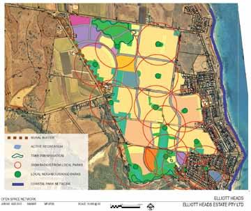
12 4.0 Elliott Heads Structure Plan 4.1 Structure Plan Concepts The structure plan as prepared requires no modification to adapt to the reduced Urban Footprint proposed in the Wide Bay Burnett Regional Plan. The permeable nature of the original layout of the road system, along with the propose uses are compatible with the objectives both of the original planning, and of the reduced area. The Ecologically Sustainable Development (ESD) principles as outline are still embodied in this development. With a mixture of housing types, and the inclusion of the small village centre, the reduced proposal, coupled with the existing Elliott Heads Community, provides the diversity of housing types, essential community facilities, and employment opportunities. All the environmental protection that was embodied in the original proposal with in the revised area will be maintained. Key land use elements remain in this proposal including: Village Centre; Urban Residential; Medium Density Residential; Lifestyle Residential; Open Space Network, and a community site within that network. Resort facilities proposed in the southern area, that are now outside the Urban Footprint, are still an approved use in the Rural Zoning. Map 3 outlines the land uses proposed within the reduced urban footprint area. The uses that are included within the urban footprint provide for a mixed community that along with the existing community will result in the creation of a sustainable mix of uses. Other uses proposed, and outside the urban footprint, are not required until a larger critical mass of development is achieved. The original permeable nature of the road network within the urban footprint has the inerrant flexibility that allows the development to proceed without any design changes. 9
13 10
14 11

15 The existing Public transport network routes already service this area, and will not require any change. With an increased population, the services will only become more viable. 4.2 Water Management The location of the catchments is well suited to the existing water management proposal, as in this part of the original proposal; the majority of the water management requirements are located within the Urban Footprint. In the west portion, it is proposed that temporary water management areas be located in the proposed buffer between the urban and rural areas. These areas could then be relocated if required in the future to allow for future expansion. 12
16 13
17 Land Use Table Elliott Heads Community - Structure Plan 28 March 2012 Land Use Precinct Areas Dwellings Areas Lot Number Land Area Provided Hectares Percentage of Total Dwellings per hectare Dwellings Mixed Use MU Elliott Heads Village Centre 1 MU % Elliott Heads Village Centre 2 MU % Elliott Heads Local Centre MU % Elliot Heads Resort MU % Resort Park 1 MU % Resort Park 2 MU % Sub-total % 5 90 Urban Residential UR Urban Residential 1 UR % Urban Residential 2 UR % Urban Residential 3 UR % Urban Residential 4 UR % Urban Residential 5 UR % Urban Residential 6 UR % Urban Residential 7 UR % Urban Residential 8 UR % 15 8 Urban Residential 9 UR % Urban Residential 10 UR % Sub-total % 14 1,308 Medium Density Residential MR Medium Density Residential 1 MR % Medium Density Residential 2 MR % Medium Density Residential 3 MR % Medium Density Residential 4 MR % Medium Density Residential 5 MR % Medium Density Residential 6 MR % Medium Density Residential 7 MR % Medium Density Residential 8 MR % Medium Density Residential 9 MR % Medium Density Residential 10 MR % Medium Density Residential 11 MR % Medium Density Residential 12 MR % Medium Density Residential 13 MR % Medium Density Residential 14 MR % Medium Density Residential 15 MR % Medium Density Residential 16 MR % Medium Density Residential 17 MR % Nursing Home MR % Sub-total % Lifestyle Residential LR Lifestyle Residential 1 LR % Lifestyle Residential 2 LR % Lifestyle Residential 3 LR % Lifestyle Residential 4 LR % Sub-total % Public Purpose PP Primary School PP % Community Purpose 1 PP % Major Road 1 PP % Major Road 2 PP % Major Road 3 PP % Major Road 4 PP % Major Road 5 PP % Major Road 6 PP % Water Management 1 PP % Water Management 2 PP % Water Management 3 PP % Water Management 4 PP % Water Management 5 PP % Water Management 6 PP % Water Management 7 PP % Water Management 8 PP % Water Management 9 PP % Water Management 10 PP % Water Management 11 PP % Water Management 12 PP % Water Management 13 PP % Water Management 14 PP % Water Management 15 PP % Major Road 7 PP % Major Road 8 PP % Sub-total % Green Space GS Recreation GS % Public Open Space 1 GS % Public Open Space 2 GS % Public Open Space 3 GS % Public Open Space 4 GS % Public Open Space 5 GS % Public Open Space 6 GS % Public Open Space 7 GS % Public Open Space 8 GS % Public Open Space 9 GS % Public Open Space 10 GS % Public Open Space 11 GS % Public Open Space 12 GS % Public Open Space 13 GS % Public Open Space 14 GS % Public Open Space 15 GS % Public Open Space 16 GS % Public Open Space 17 GS % Public Open Space 18 GS % Public Open Space 19 GS % Public Open Space 20 GS % Public Open Space 21 GS % Sub-total % - Total ,147 All areas and GFA are subject to survey and detailed design. Please note: Due to some land use areas being split into multiple stages there are some minor inherent differences in the 'Dwellings per hectare' and 'Dwellings' calculations in this table. 14


18 5.0. Implementation and Phasing Following is the preliminary staging for the development of the Elliott Heads Community. This proposed staging is indicative only, and will ultimately be determined on the demands for housing type, different uses and facilities. The development staging may also be influenced by engineering constraints, and the desire for more efficient development. To this end, the following outlines the current philosophy in regard to the staging of the development. Spatially, the development will initially occur in the east of the subject site nearest the township of Elliott Heads. It is proposed to develop this edge in accordance with the current settlement pattern of low density residential. Please refer to the Staging Plan and Staging Table, following, for confirmation of the proposed development rollout. The Elliott Heads Estate is to be developed in stages, assuming approximately 150 lots per annum, as follows: Stage 1, is planned to comprise the development of residential lots for sale incorporating a mixture of, urban residential (low density) where the development adjoins the current township, and a small release of medium density around the proposed village centre and future lakes area. A small area of medium density residential lots is proposed to assist the developer in demonstrating the intended mix of residential styles available to future residents. This stage of development will also see the partial creation of the Elliott Heads Village Centre, along with the phased development of a Tourist Village later in this stage. Other uses that will be developed in part during Stage One are public open space and road, pedestrian and cyclist networks relevant to the stage. Stage 1 is further broken down into Stages 1.1 to 1.6 Stage 1 sits entirely within the proposed Urban Footprint with the exception of the Tourist village, which sits in the southern area, and is a permitted use in Rural Zoned Land. Future stages are planned to comprise a mixture of Urban Residential and Lifestyle Residential living options following further investigation and future rezoning as outline on the Structure Plan. 15


19 It is important to create a reasonable population in the early stages of the overall development in order to support the other proposed land uses and to maintain the long-term financial viability of the project. With a development life of 20 years or more it is expected that Elliott Heads will gradually become a fully integrated seaside community contributing positively to the local existing community and surrounding regions. 16
20 17
21 Phase 1 Staging Elliott Heads Preliminary Structure Plan Land Use Precinct Areas Dwellings Areas Lot Number Land Area Provided Percentage of Total Dwellings per hectare Dwellings Hectares Stage 1:1 Urban Residential 9 UR % Medium Density Residential 13 MR % Medium Density Residential 14 MR % Elliott Heads Village Centre 1 MU % Major Road 6 PP % Public Open Space 17 GS % Public Open Space 18 GS % Water Management 11 PP % Water Management 12 PP % Water Management 13 PP % Sub-total % Stage 1:2 Lifestyle Residential 1 LR % Urban Residential 7 UR % Urban Residential 8 UR % 15 8 Major Road 7 PP % Major Road 4 PP % Public Open Space 14 GS % Public Open Space 15 GS % Sub-total % Stage 1:3 Medium Density Residential 11 MR Medium Density Residential 10 MR Medium Density Residential 12 MR Water Management 10 PP Major Road 5 PP Public Open Space 16 GS Sub-total % Stage 1:4 Urban Residential 5 UR % Elliott Heads Village Centre 1 MU % Elliott Heads Village Centre 2 MU % Medium Density Residential 9 MR % Medium Density Residential 15 MR % Medium Density Residential 16 MR % Major Road 7 PP % Major Road 4 PP % Major Road 2 PP % Public Open Space 11 GS % 05% Public Open Space 12 GS % Public Open Space 13 GS % Public Open Space 20 GS % Sub-total % Stage 1:5 Resort 1 MU % Resort 2 MU % Resort 3 MU % Major Road 2 PP % Public Open Space 19 GS % Public Open Space 21 GS % Water Management 15 PP % Water Management 14 PP % Sub-total % Stage 1:6 Urban Residential 1 UR % Urban Residential 2 UR % Urban Residential 6 UR % Medium Density Residential 7 MR % Medium Density Residential 8 MR % Medium Density Residential 6 MR % Water Management PP % Major Road 1 PP % Major Road 8 PP % Sub-total % Total Stage % ,206 18
22 Phase 2 Staging Stage 2:7 Urban Residential 5 UR % Elliott Heads Local Centre MU % 37 7 Major Road 3 PP % Public Open Space 8 GS % Public Open Space 9 GS % Public Open Space 10 GS % Sub-total % Stage 2:8 Urban Residential 2 UR % Medium Density Residential 6 MR % Medium Density Residential 7 MR % 56 5 Elliott Heads Local Centre MU % Major Road 1 PP % Public Open Space 9 GS % Sub-total % Stage 2:9 Urban Residential 1 UR % Urban Residential 2 UR % 13 4 Major Road 1 PP % Medium Density Residential MR % Medium Density Residential MR % Public Open Space GS % Sub-total % Stage 2:10 Lifestyle Residential 2 LR % Medium Density Residential 10 MR % Nursing Home MR % Public Open Space 16 GS % Water Management PP % Major Road 7 PP % Sub-total % Stage 2:11 Urban Residential 2 UR % Urban Residential 3 UR % 17 1 Medium Density Residential 6 MR % Elliott Heads Local Centre MU % Public Open Space 7 GS % Recreation GS % Water Management PP % Water Management PP % Major Road 1 PP % Sub-total % 4 47 Stage 2:12 Urban Residential 1 UR % Medium Density Residential 1 MR % Medium Density Residential 2 MR % Medium Density Residential 3 MR % Elliott Heads Local Centre MU % 14 1 Public Open Space 1 GS % Public Open Space 3 GS % Primary School PP % Major Road 1 PP % Sub-total % Stage 2:13 Urban Residential 3 UR % 12 3 Major Road 1 PP % Water Management PP % Primary School PP % Sub-total % 1 3 Stage 2:14 Urban Residential 4 UR % Urban Residential 5 UR % Elliott Heads Local Centre MU % 11 2 Major Road 3 PP % Major Road 7 PP % Water Management 6 PP % Water Management 7 PP % Water Management 8 PP % Sub-total % Total Stage % 13 1,356 Phase 3 Staging Stage 3:15 Urban Residential 3 UR % Major Road 1 PP % Major Road 2 PP % Water Management 3 PP % Water Management 4 PP % Public Open Space 5 GS % Sub-total % Stage 3:16 Major Road 1 PP % Community Purpose 1 PP % Lifestyle Residential LR % Water Management 1 PP % Public Open Space 1 GS % Public Open Space 3 GS % Sub-total % Stage 3:17 Major Road 1 PP % Major Road 1 PP % Urban Residential 3 UR % Public Open Space 5 GS % Sub-total % 8 61 Stage 3:18 Urban Residential 10 UR % Medium Density Residential 17 MR % Lifestyle Residential LR % Public Open Space 2 GS % Major Road 1 PP % Sub-total % Total Stage % Total ,148 All areas and GFA are subject to survey and detailed design. Please note: Due to some land use areas being split into multiple stages there are some minor inherent differences in the 'Dwellings per hectare' and 'Dwellings' calculations in this table. 19
23 Overall Staging Summary Elliott Heads Preliminary Structure Plan Land Use Precinct Areas Dwellings Areas Lot Number Land Area Provided Percentage of Total Dwellings per hectare Dwellings Hectares Sub-total Stage 1: % Sub-total Stage 1: % Sub-total Stage 1: % Sub-total Stage 1: % Sub-total Stage 1: % Sub-total Stage 1: % Total Stage % ,206 Sub-total Stage 2: % Sub-total Stage 2: % Sub-total Stage 2: % Sub-total Stage 2: % Sub-total Stage 2: % 4 47 Sub-total Stage 2: % Sub-total Stage 2: % 1 3 Sub-total Stage 2: % Total Stage % 13 1,356 Sub-total Stage 3: % Sub-total Stage 3: % Sub-total Stage 3: % 8 61 Sub-total Stage 3: % Total Stage % Total ,148 All areas and GFA are subject to survey and detailed design. Please note: Due to some land use areas being split into multiple stages there are some minor inherent differences in the 'Dwellings per hectare' and 'Dwellings' calculations in this table. 20

24 6.0 Conclusion Although reduced in size from the original size, the proposed development area included within the Urban Footprint will allow for a viable and sustainable extension to the Elliott Heads Community. The proposed extension will allow for a mix of development to occur, providing for a more diverse range of housing choices, and more affordable options, providing for a greater variety of residents. The extension will also permit the development of a small village centre, providing facilities that are expected in a community, convenience goods like milk and petrol, but more importantly providing the community with a social focus and employment. The structure plan design, being permeable in nature and fully integrated with the existing community is a standalone development within the Urban Footprint, and does not hinder the future development of Elliott Heads if it is deemed sustainable and desirable in the future. 21
Schedule of Planning Applications Committee Date: 23 May Reference: 06/17/0726/F Parish: Hemsby Officer: Mr J Beck Expiry Date:
 Schedule of Planning Applications Committee Date: 23 May 2018 Reference: 06/17/0726/F Parish: Hemsby Officer: Mr J Beck Expiry Date: 22-05-2018 Applicant: Proposal: Site: Mr Gillett Change of use to the
Tāhuhu whakaruruhau ā-taone The sheltering ridge pole
 B2. Tāhuhu whakaruruhau ā-taone - Urban growth and form B2.1. Issues Tāhuhu whakaruruhau ā-taone The sheltering ridge pole Auckland s growing population increases demand for housing, employment, business,
Northern Territory Compact Urban Growth Policy
 Northern Territory Compact Urban Growth Policy A Reference Policy Document to clause 2.7 (Reference to Policy) of the NT Planning Scheme May 2015 Table of Contents 1 Policy Setting... 3 1.1 Context for
Plan Modification to Chapter B2 of the Auckland Unitary Plan(AUP) Operative in part (15 November 2016)
 Operative in part (15 November 2016)") UNITARY PLAN UPDATE REQUEST MEMORANDUM TO FROM Phill Reid Linley Wilkinson DATE 25 September 2018 SUBJECT Plan Modification to Chapter B2 of the Auckland Unitary Plan(AUP) Operative in part (15 November
UNITARY PLAN UPDATE REQUEST MEMORANDUM TO FROM Phill Reid Linley Wilkinson DATE 25 September 2018 SUBJECT Plan Modification to Chapter B2 of the Auckland Unitary Plan(AUP) Operative in part (15 November
A Growing Community Rural Settlement Areas
 Town of Huntsville Official Plan Review - POLICY BACKGROUND PAPER A Growing Community Rural Settlement Areas BACKGROUND: In addition to the fully municipally-serviced Urban Settlement Area and the Hidden
Rochford District Council Allocations Development Plan Document: Discussion and Consultation Document Sustainability Appraisal
 Option SWH1 Balanced Communities Option SWH1 1 To ensure the delivery of high quality sustainable communities where people want to live and work Will it ensure the phasing of infrastructure, including
PHASE ONE. A summary report: What the community told Alcoa during Phase One of the community engagement program for Point Henry 575.
 PHASE ONE A summary report: What the community told Alcoa during Phase One of the community engagement program for Point Henry 575. DECEMBER 2015 FEBRUARY 2016 INTRODUCTION In 2014 Alcoa closed its Point
5 PLANNING ANALYSIS 5.1 THE SITE AND ITS DEVELOPMENT CONTEXT
 5 PLANNING ANALYSIS 5.1 THE SITE AND ITS DEVELOPMENT CONTEXT The Azuri IRS River Villa Complex site is situated on the western margin of Azuri Phase 1, inland. The whole site borders Rivière du Rempart
OKEFORD FITZPAINE NEIGHBOURHOOD PLAN
 OKEFORD FITZPAINE NEIGHBOURHOOD PLAN Dear Parishioner, The Neighbourhood Plan Project Team have prepared this leaflet to summarise the full Neighbourhood Plan document. It provides a summary of the Vision,
3. STATEMENTS OF DESIRED CHARACTER FOR PLANNING AREAS AND PRECINCTS
 3.30 Planning Area No. 30 Mary River Valley 3.30.1 Location and Role This Planning Area encompasses rural lands in the western part of the Shire. These lands are located within the catchment area of the
14.5 HOPEFIELD: (REFER PLAN 39 AND PLAN 40)
") URBAN DYNAMICS WESTERN CAPE INC. 248 14.5 HOPEFIELD: (REFER PLAN 39 AND PLAN 40) FIGURE 83: LOCALITY - HOPEFIELD Within the context of the Saldanha Bay Municipal area, Hopefield, an historical agricultural
URBAN DYNAMICS WESTERN CAPE INC. 248 14.5 HOPEFIELD: (REFER PLAN 39 AND PLAN 40) FIGURE 83: LOCALITY - HOPEFIELD Within the context of the Saldanha Bay Municipal area, Hopefield, an historical agricultural
RE: AMENDMENT C375 GEELONG PLANNING SCHEME 1900 BARWON HEADS ROAD, BARWON HEADS
 Reference: #V157080 14 August 2018 Barwon Heads Lifestyle Group Pty Ltd C/- Best Hooper Lawyers Level 9, 451 Little Bourke Street MELBOURNE VIC 3000 Attention: Mr. Edward Mahony (Lawyer) Dear Edward RE:
PART 02 HASTINGS POINT IN CONTEXT
 PART 02 HASTINGS POINT IN CONTEXT 2.1 Background 2.1.1 Demographic Information 2.1.2 Existing Locality Characteristics 2.2 The Planning Framework 2.2.1 The Far North Coast Regional Strategy 2006 2.2.2
Rhode Island Shoreline Change Special Area Management Plan
 Rhode Island Shoreline Change Special Area Management Plan Draft Document Outline REVISED 10/12/2017 VOLUME 1 Executive Summary & How to Use this Document (Draft by Dec 2017) 1. Introduction (Revised draft
I539. Smales 2 Precinct
 I539. Smales 2 Precinct I539.1. Precinct Description The Smales 2 Precinct applies to a 4.8 hectare block of land located on the southern side of Northcote Road and fronting Lake Pupuke, Takapuna. The
Western Sydney Parklands Australia s Largest Urban Park
 Western Sydney Parklands Australia s Largest Urban Park 37 WLA 1 MAGAZINE 21 38 WESTERN SYDNEY PARKLANDS AUSTRALIA S LARGEST URBAN PARK Large urban parks have dual roles to play in meeting the demands
TIDAPA Structure Plan
 TIDAPA Structure Plan Prepared by Tract Consultants 28 MARCH 2017 0217-0074 Table of Contents 01 STRATEGIC CONTEXT Executive Summary Regional Context Page 3 Page 4 02 LOCAL CONTEXT Aerial Photograph Local
Part 10 Other plans
 Contents of Part 10 Part 10 Other plans... 10-1 10.1 Preliminary... 10-1 10.2 Palmview Structure Plan... 10-2 10.2.1 Preliminary... 10-2 10.2.2 Master Strategic Framework... 10-6 10.2.3 Master Precincts
1.0 INTRODUCTION. Brantham Industrial Area Regeneration - Factory Lane - Brantham
 1.0 INTRODUCTION Welcome to this exhibition of our proposals for the regeneration of the Brantham Industrial Area located off Factory Lane in Brantham. This presentation will give you an opportunity to
STATEMENT OF OBJECTION TO THE PROPOSED DEVELOPMENT OF LAND AT CHURCH CLIFF DRIVE FILEY
 STATEMENT OF OBJECTION TO THE PROPOSED DEVELOPMENT OF LAND AT CHURCH CLIFF DRIVE FILEY You will be aware that Scarborough borough council have adopted a new local plan that includes land at Church Cliff
REMARKABLES PARK ZONE
 .10 Remarkables Park Zone.10.1 Resources, Activities and Values The Remarkables Park Area comprises approximately 150 hectares of perimeter urban land in the vicinity of Frankton and occupies a strategic
As is referenced in the site analysis, the current site access is along Loggers Lane and on to Galbraith Avenue.
 4.12 Archaeological Assessment The land above sea level at the Oceanfront was created over the last 100 years by the fill from dredging of the Mamquam Blind Channel, the Cattermole Slough and the Squamish
Public Consultation. Land at Monks Farm, North Grove. Welcome
 Welcome Welcome to our public exhibition for development on Land at Monks Farm, orth Grove. Gallagher Estates and Gleeson Strategic Land are preparing an outline planning application for new homes, open
DAREBIN PLANNING SCHEME AMENDMENT C137
 Who is the planning authority? Planning and Environment Act 1987 DAREBIN PLANNING SCHEME AMENDMENT C137 EXPLANATORY REPORT This amendment has been prepared by the Darebin City Council, who is the planning
Page 1 of 19 URBAN DESIGN FRAMEWORK FOR BOLTON STREET WATERFORD
 Page 1 of 19 URBAN DESIGN FRAMEWORK FOR BOLTON STREET WATERFORD 1.0 Introduction: The relocation of the City Council stores and depot from Bolton Street creates an exciting opportunity for development
GREENBANK DEVELOPMENT MASTERPLAN
 DEVELOPMENT MASTERPLAN POTENTIAL TRAIN STATION COMMUNITY CENTRE Greenbank will be a connected masterplanned community providing easy access to local and surrounding amenity. Affordable quality homes, green
WHITELEY TOWN COUNCIL NORTH WHITELEY DEVELOPMENT SEPTEMBER 2014
 WHITELEY TOWN COUNCIL NORTH WHITELEY DEVELOPMENT SEPTEMBER 2014 Dear Resident This Special Edition of the Whiteley Voice which has been prepared in conjunction with the North Whiteley Consortium is to
Sunshine Coast Council Coastal Management Overview. January 2016 edition
 Sunshine Coast Council Coastal Management Overview January 2016 edition Mayor Mark Jamieson Mayor s foreword Our impressive beaches are fundamental to our Sunshine Coast lifestyle, economy and coastal
Legal implications of failing to
 Legal implications of failing to plan for sea level rise Gavin Leydon, Partner 30 April 2010 Outline Relevance to local l government & developers assessment & policy Developments in case law Climate change
HARTENBOS NORTH (population: Census 2011)
") 5.8 HARTENBOS NORTH (population: + 184 Census 2011) Figure 5.8.1.1 Hartenbos North: Aerial photograph CNdV africa (Pty) Ltd DRAFT CONCEPTUAL DEVELOPMENT FRAMEWORK REPORT page 439 5.8.1 SPATIAL ANALYSIS,
5.8 HARTENBOS NORTH (population: + 184 Census 2011) Figure 5.8.1.1 Hartenbos North: Aerial photograph CNdV africa (Pty) Ltd DRAFT CONCEPTUAL DEVELOPMENT FRAMEWORK REPORT page 439 5.8.1 SPATIAL ANALYSIS,
Official Plan Review
 Official Plan Review Summary Report - The Built Environment August 2014 Part 1: Introduction Planning for a healthy, prosperous and sustainable community is an important goal for our municipality. From
6. THE COAST POLICY INDEX
 6. THE COAST POLICY INDEX LP/C1 Development within the Coastal Zone Page 90 LP/C2 Piers & Harbours Page 92 LP/C3 Fish Farms Page 94 LP/C4 Coastal Erosion Page 96 THE ORKNEY LOCAL PLAN - Coastal Policies
City of Rockingham. Local Management Practices, Costs and Strategic Coastal Planning
 City of Rockingham Local Management Practices, Costs and Strategic Coastal Planning Decision Making Process Considerations Climate Change Response Action Plan Ongoing observations/major Storm events Ongoing
6 PORT SYDNEY SETTLEMENT AREA
 Section 6 Port Sydney Page 61 6 PORT SYDNEY SETTLEMENT AREA 6.1 Basis and Principles Village of Port Sydney Waterfront Community Existing Services 6.1.1 Port Sydney is an historic settlement that has developed
PLANNING COMMITTEE DATE: 07/09/2015 REPORT OF THE SENIOR MANAGER PLANNING AND ENVIRONMENT SERVICE CAERNARFON. Number: 4
 Number: 4 Application Number: C15/0034/37/LL Date Registered: 21/05/2015 Application Type: Full - Planning Community: Llanaelhaearn Ward: Llanaelhaearn Proposal: Location: Summary of the Recommendation:
6 Growth Management Challenges and Opportunities
 6 Growth Management Challenges and Opportunities The Town has established a goal of attaining a 50% participation rate with respect to employment opportunities versus residential population. The Town s
Local Area Key Issues Paper No. 11: Extractive industry - Yandina Creek and Browns Creek Road
 Draft Sunshine Coast Planning Scheme Review of Submissions Local Area Key Issues Paper No. 11: Extractive industry - Yandina Creek and Browns Creek Road Key Issue: No. of submissions: Sites identified
SINGITA SWENI LODGE EXPANSION: SUMMARY REPORT - BAR
 7 PROJECT: SINGITA SWENI LODGE EXPANSION: SUMMARY REPORT - BAR Basic Environmental Assessment for Lodge expansion and Refurbishment of the Singita Sweni Lodge, within the Singita Private Concession in
elbridge Core Strategy
 C elbridge Core Strategy Celbridge is designated as a Moderate Growth Town in the RPGs. The County Development Plan reinforces this designation in its settlement strategy. Moderate Growth Towns within
WELCOME GYPSY LANE. Wider Site Location plan. Proposals for the development of LAND OFF FOXLYDIATE LANE WEBHEATH. Proposals for the development of
 WELCOME The developers are preparing an outline planning application for a residential led development and need the community s views in order to develop the proposals further WHAT IS PROPOSED? A high
2136 & 2148 Trafalgar Road Town of Oakville Region of Halton
 PLANNING JUSTIFICATION REPORT 2136 & 2148 Trafalgar Road Town of Oakville Region of Halton Zoning By-Law Amendment Application 2500674 Ontario Inc. November 2016 Table of Contents Page 1.0 Location/Summary
Edward R. Sajecki Commissioner of Planning and Building
 Corporate Report Clerk s Files Originator s Files CD.03.POR DATE: TO: FROM: SUBJECT: Chair and Members of Planning and Development Committee Meeting Date: February 27, 2012 Edward R. Sajecki Commissioner
8.0 Design and Form of Development 43/
 42/ 8.0 Design and Form of Development 43/ Rothwells Farm, Golborne/ Development Statement Figure 7. Site Constraints Key 44/ Site Boundary 360 Bus Route/Stops Existing Trees Underground Water Pipe Sensitive
Contents of Part 6. Part 6 Zones
 Contents of Part 6 Part 6 Zones... 6-1 6.1 Preliminary... 6-1 6.2 Zone codes... 6-3 6.2.1 Low density residential zone code... 6-3 6.2.1.1 Application... 6-3 6.2.1.2 Purpose and overall outcomes... 6-3
SECTION IV: DEVELOPMENT CONCEPT
 80 SECTION IV: DEVELOPMENT CONCEPT Section IV: DEVELOPMENT CONEPT This section provides an overall understanding and rationale for what is envisioned in The Preserve, the intended quality and character
2.0 Strategic Context 4
 2.0 Strategic Context 4 2.1 The Area Action Plan is a non-statutory plan, which forms a corporate policy document, expressing particular issues and areas of concern while also providing a vision for the
Mollers Lane, Leopold, Victoria Significant Landscape Overlay Re-assessment
 XURBAN Mollers Lane, Leopold, Victoria Significant Landscape Overlay Re-assessment For: TGM Group November 2016 Final Mollers Lane, Leopold, Victoria Significant Landscape Overlay Re-assessment Client
Planning Proposal Toronto Road, Booragul. Amendment to Lake Macquarie Local Environmental Plan (LMLEP) 2014
 2014") Planning Proposal Toronto Road, Booragul Amendment to Lake Macquarie Local Environmental Plan (LMLEP) 2014 Local Government Area: Name of Draft LEP: Subject Land: Land Owner: Applicant: Folder Number:
Planning Proposal Toronto Road, Booragul Amendment to Lake Macquarie Local Environmental Plan (LMLEP) 2014 Local Government Area: Name of Draft LEP: Subject Land: Land Owner: Applicant: Folder Number:
Subdivision Design Criteria. Penihana North GUIDELINES TO THE RULES
 Created September 2013 Penihana North Subdivision Design Criteria GUIDELINES TO THE RULES This part of the Plan sets out the design criteria for subdivision in Penihana North. The criteria will be considered
Droitwich Spa 6. Reasoned Justification
 87 Droitwich Spa 6 Reasoned Justification 6.1 Droitwich Spa is identified in the settlement hierarchy (Policy SWDP1) as a main town being the largest settlement in Wychavon District with an estimated population
Neighbourhood Planning Site Assessment Pro-forma and Guide Version 2
 Neighbourhood Planning Site Assessment Pro-forma and Guide Version 2 September 2014 Site HNP 006 Land East of Stanbridge Road and North of Lower Road 1. Background information Site location and use Site
STRATEGIC DIRECTION. QLDC PROPOSED DISTRICT PLAN [PART TWO] DECISIONS VERSION 3 strategic direction
![STRATEGIC DIRECTION. QLDC PROPOSED DISTRICT PLAN [PART TWO] DECISIONS VERSION 3 strategic direction](/thumbs/79/79711764.jpg "STRATEGIC DIRECTION. QLDC PROPOSED DISTRICT PLAN [PART TWO] DECISIONS VERSION 3 strategic direction") 3 STRATEGIC DIRECTION QLDC PROPOSED DISTRICT PLAN [PART TWO] DECISIONS VERSION 3 strategic direction QLDC DISTRICT PLAN [PART TWO] AUGUST 2015 3 strategic direction 3.1 Purpose This chapter sets out the
3 STRATEGIC DIRECTION QLDC PROPOSED DISTRICT PLAN [PART TWO] DECISIONS VERSION 3 strategic direction QLDC DISTRICT PLAN [PART TWO] AUGUST 2015 3 strategic direction 3.1 Purpose This chapter sets out the
THREE PARKS ZONE Three Parks Special Zone The process of applying for resource consents in the zone.
 .25 Three Parks Special Zone The purpose of this zone is to provide for growth and to give effect to the Wanaka 2020 Community (2002) and the more recent Wanaka Structure (2007) and Wanaka Transport Strategy
OCEAN GROVE STRUCTURE PLAN
 OCEAN GROVE STRUCTURE PLAN December 2015 1 WWW.GEELONGAUSTRALIA.COM.AU 2 Contents Part A Structure Plan 1 Introduction... 5 1.1 Purpose of the Structure Plan 5 1.2 How will this plan be used? 5 1.3 Plan
2A District-wide Policies
 2A Introduction This Chapter contains policies which are relevant to subdivision, use and development activities occurring across all zones and areas of the District. The policies in this Chapter implement
Plumpton Neighbourhood Development Plan Revised Pre Submission Document - Regulation 14 Consultation
 REPRESENTATIONS... Plumpton Parish Council Plumpton Neighbourhood Development Plan Revised Pre Submission Document - Regulation 14 Consultation Representations submitted on behalf of: Cala Homes (South
Planning Proposal Concurrent DA/LEP Amendment for Belmont North Pharmacy Amendment No. 24 to Lake Macquarie Local Environmental Plan (LMLEP) 2014
 2014") Planning Proposal Concurrent DA/LEP Amendment for Belmont North Pharmacy Amendment No. 24 to Lake Macquarie Local Environmental Plan (LMLEP) 2014 Local Government Area: Name of Draft LEP: Subject Land:
Planning Proposal Concurrent DA/LEP Amendment for Belmont North Pharmacy Amendment No. 24 to Lake Macquarie Local Environmental Plan (LMLEP) 2014 Local Government Area: Name of Draft LEP: Subject Land:
Emery Village Road 2A Municipal Class Environmental Assessment Study
 PW12.11 STAFF REPORT ACTION REQUIRED Emery Village Road 2A Municipal Class Environmental Assessment Study Date: March 30, 2016 To: From: Wards: Reference Number: Public Works and Infrastructure Committee
17A. Wind Microclimate
 17A. Wind Microclimate 17A.1 Introduction 17A.1.1 17A.1.2 17A.1.3 17A.1.4 This Chapter, which has been prepared by Waterman and BMT, provides further information with regard to the potential wind microclimate
Appendix 1 Structure plan guidelines
 Appendix 1 Structure plan guidelines This appendix forms part of the regional policy statement [rps]. 1.1. Introduction Structure plans are an important method for establishing the pattern of land use
Ashbridges Bay Erosion and Sediment Control Project
 Ashbridges Bay Erosion and Sediment Control Project Project Brief Overview Toronto and Region Conservation Authority, in partnership with the City of Toronto, intends to carry out remedial erosion control
LAND USE AMENDMENT CORNERSTONE (WARD 3) 60 STREET NE AND COUNTRY HILLS BOULEVARD NE MAP 26NE BYLAW 22D2017
 60 STREET NE AND COUNTRY HILLS BOULEVARD NE MAP 26NE BYLAW 22D2017") Page 1 of 14 EXECUTIVE SUMMARY This Land Use Amendment application covers an area of 43.76 hectares ± (108.14 acres ±) located in northeast Calgary, bound by Country Hills Boulevard NE to the south and
Page 1 of 14 EXECUTIVE SUMMARY This Land Use Amendment application covers an area of 43.76 hectares ± (108.14 acres ±) located in northeast Calgary, bound by Country Hills Boulevard NE to the south and
Chapter 2: OUTLINE PLANNING APPLICATION PROPOSALS. A New Garden Neighbourhood Matford Barton 17
 Chapter 2: OUTLINE PLANNING APPLICATION PROPOSALS A New Garden Neighbourhood Matford Barton 17 2.1. SUMMARY AND STATUS OF THE PROPOSALS 2.1.1. The parameter plans and associated wording in this chapter
INTRODUCTION. Land south of Bishopswood Lane, Tadley
 0 INTRODUCTION THE SITE Introduction Gladman Developments Ltd. has successfully invested in communities throughout the UK over the past 0 years, developing high quality and sustainable residential, commercial
Welcome to our exhibition
 Welcome to our exhibition The Homes & Communities Agency (HCA) welcomes you to this public exhibition explaining our proposals for the redevelopment of the former Lea Castle Hospital site. About the Homes
Planning Proposal Charlestown Swim and Leisure Centre LEP Amendment
 Planning Proposal Charlestown Swim and Leisure Centre LEP Amendment Amendment No. 4 to Lake Macquarie Local Environmental Plan 2014 (PP_2014_LAKEM_005_00) Local Government Area: Name of Draft LEP: Lake
RECREATION, OPEN SPACE AND GREENWAYS ELEMENT GOALS, OBJECTIVES, AND POLICIES
 RECREATION, OPEN SPACE AND GREENWAYS ELEMENT GOALS, OBJECTIVES, AND POLICIES GOAL R-1: DEVELOP A RECREATION, OPEN SPACE AND GREENWAYS SYSTEM AS AN INTEGRAL COMPONENT OF AN OVERALL, COUNTY-WIDE ECONOMIC
DRAFT FOR YOUR FEEDBACK DRAFT LOGAN RESERVE PLAN
 DRAFT FOR YOUR FEEDBACK CONTENTS INTRODUCTION... BACKGROUND... State Government... Council... PLANNING LEGISLATION AND RULES... CONSULTATION PROCESS...... ENVIRONMENT AND CONSERVATION... HOUSING... Proposed
4 RESIDENTIAL ZONE. 4.1 Background
 4 RESIDENTIAL ZONE 4.1 Background The residential areas within the City are characterised by mainly lowrise dwellings sited on individual allotments. Past architectural styles, settlement patterns and
Derry City and Strabane District Council Planning Committee Report
 Derry City and Strabane District Council Planning Committee Report COMMITTEE DATE: 20.12.2017 APPLICATION No: APPLICATION TYPE: PROPOSAL: LOCATION: APPLICANT: AGENT: A/2014/0495/F Full Construction of
Cardiff International Sports Village Waterfront Development Volume IV : Non-Technical Summary of the Environmental Statement
 Greenbank Partnerships Ltd October 2012 Cardiff International Sports Village Waterfront Development Volume IV : Non-Technical Summary of the Environmental Statement Environmental Statement - Non Technical
28. Coolaney-Rockfield Mini-Plan
 28. Coolaney-Rockfield Mini-Plan 28. Coolaney-Rockfield Mini-Plan Community facilities Community facilities in Coolaney-Rockfield consist of a primary school, crèche, community centre, sports field and
Assessment of Landscape, Visual and Natural Character Effects
 Assessment of Landscape, Visual and Natural Character Effects Consent Footprint Amendments Mangamaunu Half Moon Bay Okiwi Bay South Report prepared for: New Zealand Transport Agency and KiwiRail Holdings
Sustainability Statement. Whitby Business Park Area Action Plan
 Sustainability Statement Whitby Business Park Area Action Plan November 2014 Contents Page 1. Introduction 1 2. Scoping 3 3. Sustainability Appraisal of Options 6 4. Assessment of Draft Area Action Plan
Four Big Ideas. Three Key Opportunities. Principles. Draft Place Making Master Plan. 1. The Foreshore 2. Green Links. 3.
 project background Four Big Ideas 1. The Healthy Thriving Place. An International Focus 3. Reclaiming Mooloolaba 4. The Resort Heart of the Coast In November 01 a big ideas workshop was held involving
HAYLE NEIGHBOURHOOD PLAN FUTURE HOUSING EXPANSION VISION DOCUMENT. Prepared for Hayle Neighbourhood Plan Steering Group by AECOM
 HAYLE NEIGHBOURHOOD PLAN FUTURE HOUSING EXPANSION VISION DOCUMENT Prepared for Hayle Neighbourhood Plan Steering Group by AECOM December 2015 1. Introduction Context Hayle is a linear town situated in
Derry City and Strabane District Council Planning Committee Report
 Derry City and Strabane District Council Planning Committee Report COMMITTEE DATE: 23 rd March 2016 APPLICATION No: APPLICATION TYPE: PROPOSAL: LOCATION: APPLICANT: LA11/2015/0395/F Residential Development
Wireless Hill Vision 2020
 Wireless Hill Vision 2020 Key Themes and Objectives for the Future of Wireless Hill Revision: Draft Issue Date: 23/04/2009 Document No: Wireless Hill Vision 2020 Page 1 4/30/2009 Table of Contents 1 Overview...
Site ref: AS06 Site Name or Address: Murreys Court, Agates Lane
 Site ref: AS06 Site Name or Address: Murreys Court, Agates Lane Proposed Land Use: Total Site Area (Ha): Housing 1.85 Ha Description: It is understood that the owner has no plans to dispose of the site
STRATEGIC IMPLEMENTATION PANEL SUBMISSION
 STRATEGIC IMPLEMENTATION PANEL SUBMISSION AMENDMENT C375 to the GREATER GEELONG PLANNING SCHEME BARWON HEADS STRUCTURE PLAN IMPLEMENTATION Part A Submission to the Independent Panel Panel: Con Tsotsoros
The Proposed Auckland Unitary Plan (notified 30 September 2013)
") 3 Business zones Introduction There are 10 business zones in the Unitary Plan: City Centre Metropolitan Centre Town Centre Local Centre Neighbourhood Centre Mixed Use General Business Business Park Light
3 Business zones Introduction There are 10 business zones in the Unitary Plan: City Centre Metropolitan Centre Town Centre Local Centre Neighbourhood Centre Mixed Use General Business Business Park Light
6.0 Land Use Policies for Rural Settlements. 6.1 Rural Settlement Strategy
 6.0 Land Use Policies for Rural Settlements 6.1 Rural Settlement Strategy INTRODUCTION AMENDMENT NO. 131 PURPOSE Designated rural settlements comprise Rural Clusters, Villages and Serviced Villages as
Rural Land Use Designations Kittitas County December 6, 2007 Draft
 KITTITAS COUNTY COMMUNITY DEVELOPMENT SERVICES 411 N. Ruby St., Suite 2, Ellensburg, WA 98926 CDS@CO.KITTITAS.WA.US Office (509) 962-7506 Fax (509) 962-7682 Rural Land Use Designations Kittitas County
Draft Western District Plan
 Powered by TCPDF (www.tcpdf.org) Draft Western District Plan Submission_id: 31440 Date of Lodgment: 15 Dec 2017 Origin of Submission: Online Organisation name: Goodman Property Services Australia Pty Ltd
WELCOME. Land west of Great Canfield Road, Takeley. Welcome. Have your say. Pegasus Urban Design
 01 WELCOME Welcome Gladman Developments Ltd have successfully invested in communities throughout the UK over the past 20 years, developing high quality and sustainable residential, commercial and industrial
Evesham 7. Reasoned Justification
 95 Reasoned Justification 7.1 Evesham is situated within the Vale of Evesham and has an estimated population of 22,800 (2009 Mid-Term Population Estimates). As a main town it provides a wide range of services
CAERNARFON DEPENDENCY CATCHMENT AREA
 CAERNARFON DEPENDENCY CATCHMENT AREA GWYNEDD UNITARY DEVELOPMENT PLAN - HOUSING Map not to scale Dependency Catchment Area Location 2 Caernarfon Topic Housing To the rear of Bro Eglwys, Bethel. Grid Ref.
Local Development Scheme
 Local Development Scheme 2012 2016 The Local Development Scheme (LDS) is a project plan that outlines how and when the Authority will update its planning policies and other associated documents. It ensures
GREEN BELTS, GREEN WEDGES OR DISPUTED GROUND
 GREEN BELTS, GREEN WEDGES OR DISPUTED GROUND John Ginivan Department of Planning and Community Development State Government of Victoria Melbourne Australia Greenbelts: Local Solutions for Global Challenges
Complete Neighbourhood Guidelines Review Tool
 Complete Neighbourhood Guidelines Review Tool Prepared By: City of Regina Planning Department October 2014 Page 1 of 14 Community Development Review Checklist for Secondary Plans and Concept Plans The
Planning Districts INTRODUCTION
 INTRODUCTION To facilitate detailed examination of development prospects for all areas of the community, Delano has been divided into 14 planning districts. The location of these planning districts is
STORMWATER FLOOD REPORT
 OREWA COASTAL RETIREMENT RESORT 25 ANNALISE PLACE OREWA for COASTAL PROPERTIES LTD STORMWATER FLOOD REPORT Job No. 1847 March 2016 Orewa Coastal Retirement Resort Page 1 of 9 CONTENTS Item Description
COMMUNITY ACTIONS for a SUSTAINABLE BARWON HEADS. February 2016
 COMMUNITY ACTIONS for a SUSTAINABLE BARWON HEADS February 2016 Acknowledgements Traditional Owners We acknowledge the traditional owners of this land and pay our respects to their elders past and present,
Section 3b: Objectives and Policies Rural Environment Updated 19 November 2010
 Page 1 of Section 3b 3b RURAL ENVIRONMENT 3b.1 Introduction The Rural Environment comprises all the land outside of the Residential, Town Centre and Industrial Environments. Most land within the District
INCREMENTAL CHANGE AREA REVIEW March 2015 Page 1
 INCREMENTAL CHANGE AREA REVIEW March 2015 Page 1 Table of Contents Introduction... 3 Background to Review... 3 Comparison of the Schedules to the General Residential Zone... 7 Methodology... 7 Policy Context...
URBAN DEVELOPMENT QLDC PROPOSED DISTRICT PLAN [PART TWO] AUGUST 2015
![URBAN DEVELOPMENT QLDC PROPOSED DISTRICT PLAN [PART TWO] AUGUST 2015](/thumbs/80/81778199.jpg "URBAN DEVELOPMENT QLDC PROPOSED DISTRICT PLAN [PART TWO] AUGUST 2015") 4 URBAN VLOPMNT U R P QLC PROPO ITRICT PLAN [PART TWO] AUGUT 2015 4 ur b an de v elop ment QLC ITRICT PLAN [PART TWO] AUGUT 2015 4 urban development 4 2 4.1 Purpose The purpose of this Chapter is to set
4 URBAN VLOPMNT U R P QLC PROPO ITRICT PLAN [PART TWO] AUGUT 2015 4 ur b an de v elop ment QLC ITRICT PLAN [PART TWO] AUGUT 2015 4 urban development 4 2 4.1 Purpose The purpose of this Chapter is to set
HURON COMMUNITY PLAN
 CITY OF KITCHENER DEPARTMENT OF DEVELOPMENT AND TECHNICAL SERVICES PD 94/7 HURON COMMUNITY PLAN Recommended by Planning and Economic Development Committee: October 31, 1994 Adopted by Kitchener City Council:
A CONCEPTUAL PROPOSAL BY THE UMDLOTI FORUM Representing the Umdloti Ratepayers and Residents Association and the emdloti UIP
 A CONCEPTUAL PROPOSAL BY THE UMDLOTI FORUM Representing the Umdloti Ratepayers and Residents Association and the emdloti UIP PRESENTATION STRUCTURE 1.0 Overview of Umdloti 2.0 Current challenges in Umdloti
10.0 Open Space and Public Realm
 10.0 Open Space and Public Realm 10.0 Open Space and Public Realm The Public Open Space System is comprised of: outdoor spaces available for public use that are either publicly owned (e.g., parks and
Part 12 Precinct Area Plans - Wyee West
 TABLE OF CONTENTS 1 INTRODUCTION... 1 1.1 BACKGROUND... 1 1.2 EXTENT OF AREA PLAN... 1 1.3 EXISTING CHARACTER... 2 1.4 ENVIRONMENTAL ATTRIBUTES AND CONSTRAINTS... 2 1.5 DESIRED FUTURE CHARACTER... 3 1.6