3 Ontario Ministry of Transportation s GTA West Transportation Corridor Environmental Assessment
|
|
|
- Aubrey Park
- 5 years ago
- Views:
Transcription
1 Clause 3 in Report No. 4 of Committee of the Whole was adopted, without amendment, by the Council of The Regional Municipality of York at its meeting held on March 24, Ontario Ministry of Transportation s GTA West Transportation Corridor Environmental Assessment Committee of the Whole recommends: 1. Receipt of the communication from Paula Tenuta, Vice President, Policy & Government Relations, BILD, dated March 1, Adoption of the following recommendations contained in the report dated February 17, 2016 from the Commissioner of Transportation Services: 1. Council request that the Ministry of Transportation resume the GTA West Transportation Corridor Environmental Assessment and define the preferred alignment as soon as possible. 2. The Regional Clerk circulate this report to the Minister of Transportation, Minister of Municipal Affairs and Housing, Members of Provincial Parliament within York Region, Regions of Peel and Halton and the Clerks of local municipalities. Report dated February 17, 2016 from the Commissioner of Transportation Services now follows: 1. Recommendations It is recommended that: 1. Council request that the Ministry of Transportation resume the GTA West Transportation Corridor Environmental Assessment and define the preferred alignment as soon as possible. 2. The Regional Clerk circulate this report to the Minister of Transportation, Minister of Municipal Affairs and Housing, Members of Provincial Committee of the Whole 1 Transportation Services March 3, 2016
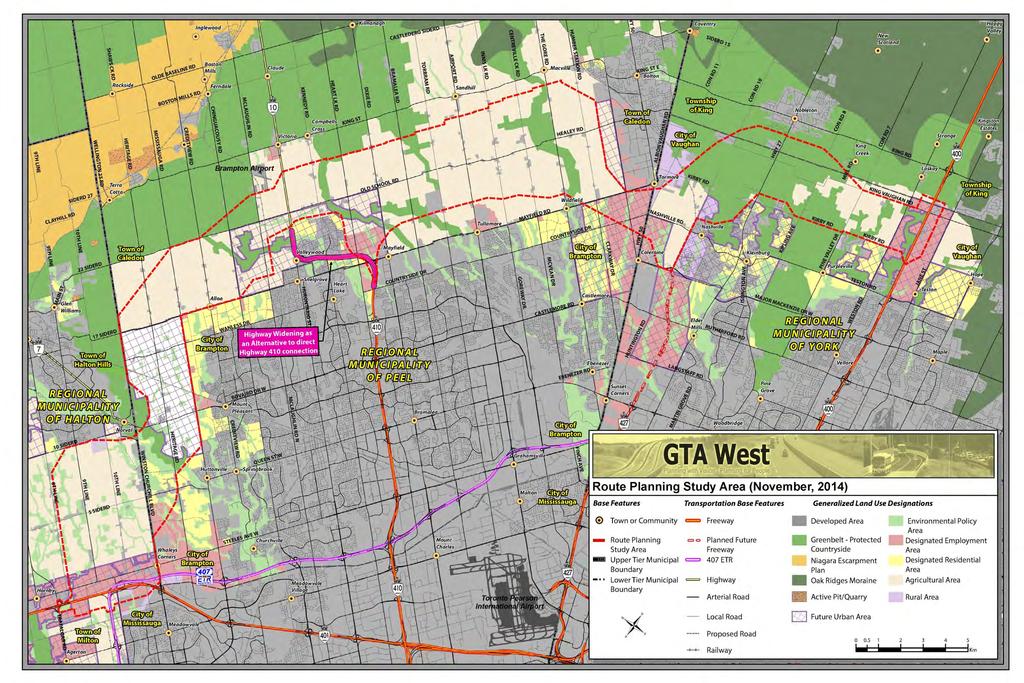
2 Ontario Ministry of Transportation s GTA West Transportation Corridor Environmental Assessment Parliament within York Region, Regions of Peel and Halton and the Clerks of local municipalities. 2. Purpose This report provides Council with an update on the Ontario Ministry of Transportation s (MTO) GTA West Transportation Corridor Environmental Assessment (EA) and recommends MTO resume the EA and define the preferred alignment of the corridor as soon as possible. 3. Background MTO initiated the Terms of Reference phase of the EA in 2007, followed by an Individual EA scheduled for completion in 2018 MTO initiated the GTA West Transportation Corridor Environmental Assessment study (Study) in February As an Individual EA, a Terms of Reference was prepared for approval by the Ministry of the Environment. The Terms of Reference was approved in March Following approval, the first stage of the Individual EA included preparing a transportation network strategy to address needs within the Study area. The transportation network strategy identified the GTA West Transportation Corridor (Corridor) preliminary route planning study area extending from Highway 401 in Halton Region to Highway 400 in the City of Vaughan. The new Corridor will extend from Highway 400 between Kirby Road and King- Vaughan Road in the east to the Highway 401/407 ETR interchange area between Winston Churchill Boulevard and Trafalgar Road in the west. The Corridor is proposed to be a four to six lane freeway with connections at Highway 401/407ETR, Highway 410, Highway 427 and Highway 400. A separate adjacent transitway is also included in the scope of the EA, with proposed stations located at interchanges and connecting points. The Study area within York Region is shown in Attachment 1. Stage 1 of the EA was completed with publication of a Transportation Development Strategy Report in November Committee of the Whole 2 Transportation Services March 3, 2016
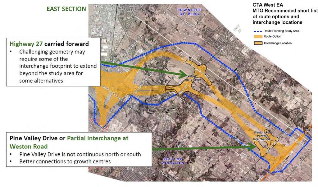
3 Ontario Ministry of Transportation s GTA West Transportation Corridor Environmental Assessment Stage 2 of the EA will identify the recommended route, determine interchange locations, complete the preliminary design for the new Corridor and ultimately secure EA approval to protect the Corridor while allowing development to proceed outside the affected lands. The Notice of Study Commencement for this phase of the Individual EA is shown in Attachment 2. MTO project staff presented the Study to Committee of the Whole in March 2015 MTO project staff delivered a presentation to Committee of the Whole, providing an update on the project status and next steps. Of specific interest to Committee of the Whole was the timing for identifying a preferred alternative and completing Stage 2 of the Individual EA process. MTO, in March 2015, advised the preferred alternative would be identified by late 2015 and the Individual EA was on schedule for completion in A short-list of corridor alignments and interchange locations were presented to municipal stakeholders in mid-2015 MTO has undertaken public, municipal and other stakeholder consultation throughout the Study. Staff acknowledge MTO s efforts to consult York Region and local municipalities throughout the Study and recommend MTO continue to engage York Region and local municipalities throughout the EA process. The MTO recommended short-list of corridor alignments and interchange locations are presented in Attachment 3. Alignment alternatives start from Highway 400 between King-Vaughan Road and Kirby Road and extend westerly into Peel Region. Near the York/Peel boundary area, the alignment alternatives cross south of Bolton. Freeway to freeway interchanges are proposed by MTO at Highway 427 and Highway 400. Interchanges at municipal arterial roads are proposed at Highway 27 (full) and at Weston Road (partial). In December 2015, the Minister of Transportation announced the EA was being suspended pending review In early December 2015, MTO provided a Study update indicating that Public Information Centre #2 for the EA was not taking place in December 2015 as had been planned. A copy of the MTO Study update is provided in Attachment 4. Committee of the Whole 3 Transportation Services March 3, 2016
4 Ontario Ministry of Transportation s GTA West Transportation Corridor Environmental Assessment On December 16, 2015, the Minister of Transportation released a media bulletin indicating that work on the EA was being suspended pending review and that an update will be provided in spring The Minister s bulletin is provided in Attachment Analysis and Options An expanded freeway network is identified as an essential component in York Region s Transportation Master Plan York Region recognizes the importance of aligning transportation network plans at all levels of government. Ensuring alignment of the integrated transportation network maximizes the effectiveness and efficiency of infrastructure in meeting transportation demands associated with managing congestion and accommodating growth. An expanded freeway network is an essential component for the Region s growth. The Corridor provides a critical east-west link connecting Highway 400 to Highway 401 which accommodates goods movement and servicing of future employment lands in the City of Vaughan. Staff provided written comments on the Study to MTO in July 2015 (see Attachment 6) and have continuously supported a new freeway Corridor. Detailed comments highlight York Region s position regarding interchange locations, transit connections, active transportation crossings as well as other corridor planning and design considerations. MTO s written response to staff comments is provided in Attachment 7. The Region s Transportation Master Plan is being closely coordinated with the Municipal Comprehensive Review. Comments provided as input to MTO for this Study are based on infrastructure needs to accommodate population and employment growth mandated by the Growth Plan to York Region and its local municipalities are doing their part to implement needed municipal infrastructure for growth and are relying on the Province to assist with connecting provincially-designated growth centres for all modes of travel, including freeway auto and bus service, provide better connections to residential and employment lands and address needs for goods movement. The Corridor is needed for growth in the GTA The GTA West is an important transportation corridor for the GTA. The Corridor will alleviate existing congestion on major sections of Highways 400 and 401 and Committee of the Whole 4 Transportation Services March 3, 2016
5 Ontario Ministry of Transportation s GTA West Transportation Corridor Environmental Assessment provide freeway capacity for a significant amount of growth in York, Peel and Halton Regions. The Corridor will provide capacity for goods movement and impact the Province s ability to attract and retain employment in the GTA. Land use in the Study area is shown in Attachment 8. The Study area impacts a number of development areas in Vaughan, including Vaughan 400 North Employment Area Secondary Plan, Kleinburg-Nashville Secondary Plan and West Vaughan Employment Area Secondary Plan. Suspension of the EA will have an impact on land use planning in the area, including development of designated employment lands. Given suspension of the GTA West study, the amount of Vaughan lands frozen by the Province remains as shown on Attachment 1. This not only hampers land use planning efforts for already designated employment lands as noted above, but it frustrates the current Regional Municipal Comprehensive Review process and York Region s ability to review and finalize future employment land opportunities. Link to key Council-approved plans This report links to the following Council-approved plans and policies: Regional Official Plan To work with the Province and local municipalities to plan for and protect for transportation corridors and facilities, including the GTA West Corridor To support an interconnected and efficient system for goods movement through the completion of the 400-series highway network, including the GTA West Transportation Corridor and Highway 427 extension To plan and coordinate cross-boundary transportation needs with adjacent municipalities and appropriate agencies 2015 to 2019 Strategic Plan Manage Environmentally Sustainable Growth Managing traffic congestion - increasing capacity of road network Strengthen the Region s Economy Focusing on networks and systems that connect people, goods and services Complete and implement the Transportation Master Plan Committee of the Whole 5 Transportation Services March 3, 2016
6 Ontario Ministry of Transportation s GTA West Transportation Corridor Environmental Assessment 5. Financial Implications Provincial investment in a new freeway system, and specifically connectivity with the arterial road system, is important to accommodate future travel demand and strategic goods movement for planned growth. Tolls for the Corridor have not been confirmed by MTO at this stage. Tolls, even partial tolling of selective lanes, would provide a potential additional funding source to construct the Corridor, including elements such as additional interchanges required to align and integrate MTO s plans with municipal plans. MTO s decision to suspend the EA will likely delay completion of the EA and future implementation of the highway. This will affect network capacity in this area of York Region, which will place increasing burden on Regional and Municipal infrastructure. 6. Local Municipal Impact Local municipalities were contacted by the EA project team and representatives have attended Municipal Advisory meetings. Local municipalities will continue to be consulted throughout this EA. The alignment alternatives have potential impacts to a number of development areas in Vaughan, including Vaughan 400 North Employment Area Secondary Plan, Kleinburg-Nashville Secondary Plan and West Vaughan Employment Area Secondary Plan. MTO is working with City of Vaughan to ensure that the Corridor alignment alternatives are protected within development plans. MTO s recent decision to suspend the EA will have a significant impact on land use planning in the vicinity of the Study area. Continued uncertainty on the location of the preferred alignment means significant areas of land may be frozen from development, and community planning in northern Vaughan will be challenged. 7. Conclusion MTO work on the GTA West Transportation Corridor EA is currently suspended pending review and an update is anticipated in spring This is an important Committee of the Whole 6 Transportation Services March 3, 2016
7 Ontario Ministry of Transportation s GTA West Transportation Corridor Environmental Assessment transportation corridor for the GTA. York Region encourages the Ministry of Transportation to restart and complete the EA as soon as possible. Suspension of the EA will have a significant impact on land use planning in the Study area, including development of designated employment lands. For more information on this report, please contact Stephen Collins, Director of Infrastructure Management and PMO, at ext The Senior Management Group has reviewed this report. February 17, 2016 Attachments (8) Accessible formats or communication supports are available upon request Committee of the Whole 7 Transportation Services March 3, 2016

8 Attachment 1 March 3,
 has initiated stage 2 of the Environmental Assessment (EA) study for the GTA West Transportation Corridor.")
9 ONTARIO GOVERNMENT NOTICE Notice of Commencement- GTA West Transportation Corridor Route Planning and Environmental Assessment Study, Stage 2 THE STUDY The Ontario Ministry of Transportation (MTO) has initiated stage 2 of the Environmental Assessment (EA) study for the GTA West Transportation Corridor. Building on the recommendations from Stage 1, the EA Study continues with a focus on identifying the route and developing the preliminary design for a new transportation corridor within the previously identified Route Planning Study Area. The new transportation corridor will include a 400-series highway, a transitway and potential goods movement priority features. As part of the study, a preferred route and interchange locations will be selected and developed. The GTA West transportation corridor is vital towards providing the transportation infrastructure to meet the projected growth in both population and employment identified in the Growth Plan for the GnJater Golden Horseshoe (2006) and will deliver multiple benems, including: Greater connectivity between urban growth centres; Enhanced people and goods movement; Improved commuting; and Greater economic vitality. The GTA West Transportation Corridor Route Planning and EA Study is being undertaken as an Individual EA in accordance with the Ontario Environmental Assessment Act (EA Act) and the GTA West Co"idor Environmental Assessment Terms of Reference, which was approved by the Ontario Minister of the Environment on March 4, This new transportation corridor is only one component of the full suite of multi-modal recommendations that are included in the Transportation Development strategy (TDS) developed as part of stage 1. These recommendations also included transit improvements, transportation demand management measures, opportunities to optimize the existing transportation system as well as widening of several key provincial facilities in the western GTA. These recommendations are being pursued as separate initiatives. PUBLIC INVOLVEMENT Public involvement is encouraged and Public Information Centers (PICs) and Community Workshops w ill be held throughout the study. Notices advising of the time and location of the PIGs w ill be published in local and regional newspapers and advertised on the study website. If you are interested in the study and would like to be added to the mailing list, please contact the Project Team via the contact information outlined below. Study information w ill be posted and updated on the project website: COMMENTS Comments and input regarding this study are encouraged and w ill be collected to assist the Project Team. This material will be maintained on file for use during the project and may be included in project documentation to meet the requirements of the EA Act. Information collected w ill be used in accordance with the Freedom of Information and Protection of Privacy Act and the Access to Information Act. With the exception of personal information, all comments will become part of the public record. For further information, please visit our project website at the address provided above. To contact the Project Team directly, please send an to: project _team@gta-wes1.com or contact: Ms. Natalie Rouskov, P.Eng., MTO Project Manager Ontario Ministry of Transportation, Central Region 1201 Wilson Avenue, Building D, 4th Floor Toronto, ON M3M 1 J8 tel: fax: project_team@gta-west.com Des renseignements son! disponibles en franyais en composant , poste 1471 (Yannick Garnier). Mr. Nell Ahmed, P.Eng., Consultant Project Manager MMM Group Lirriled 2655 North Sheridan Way, Suite 300 Mississauga, ON LSK 2P8 tel: fax: e-rmil: project_team@gta-west.com Attachment f?ontarto
10 Attachment 3

11 Attachment 4 December 2015 STUDY UPDATE Public Information Centre (PIC) #2 for Stage 2 of the GTA West Transportation Corridor Route Planning and Environmental Assessment (EA) Study is not taking place this December as planned. The ministry needs more time as this is a complex study. The ministry will provide more information as soon as it becomes available. The EA Study The Ontario Ministry of Transportation (MTO) is undertaking Stage 2 of the Environmental Assessment (EA) Study for the GTA West Tra nsportation Corridor. Building on the recommendations from Stage 1, the EA Study will identify the route, determine interchange locations and complete the preliminary design for a new transportation corridor within the Route Planning Study Area. The new transportation corridor will include: a 400-series highway, transitway and potential goods movement priority features. The GTA West Transportation Corridor is vital transportation infrastructure that will help meet the projected growth in both population and employment identified in the Growth Plan for the Greater Golden Horseshoe {2006}, and will deliver multiple benefits including: Greater connectivity between urban growth centres; Enhanced people and goods movement; Improved commuting; and, Greater economic vitality. The GTA West Transportation Corridor Planning and EA Study is being undertaken as an Individual EA in accordance with the Ontario Environmental Assessment Act (EA Act) and the GTA West Corridor Environmental Assessment Terms of Reference, which was approved by the Ontario Minister of the Environment on March 4, Consultation and Contact Information Comments and input regarding the study are encouraged and w ill continue to be collected to assist the GTA West Project Team. This material will be maintained on file for use during the project and may be included in project documentation to meet the requirements of the Ontario EA Act. Information collected will be used in accordance with the Freedom of Information and Protection of Privacy Act and the Access to Information Act. With the exception of personal information, all comments will become part of the public record..,., I.- I ; I I the,gta West P,roject Team: project team@gta-west.com Des renseignements sont disponibles en fran~is en composant (905) Paste 1471 (Yannick Garnier) ia'-'- MMMGROUP A: COM -:> Er Ontario
12 Attachment 5
13 Attachment 6 Transportation Services Fax No July 27,2015 Ms. Natalie Rouskov, P. Eng. MTO Project Manager Ontario Ministry of Transportation, Central Region 1201 Wilson Ave, Building D, 4 1 h Floor Toronto, Ontario M3M 118 Dear Ms. Rouskov: Re: GTA West Transportation Corridor Environmental Assessment Study Thank you for inviting York Region staff to a workshop on June 29, 2015 at the City of Vaughan's Municipal Offices to discuss the GTA West Corridor EA Study. York Region recognizes the importance of the GTA West transportation corridor and we strongly support this Provincial initiative. We wish to take this opportunity to document York Region's position regarding interchange locations as well as other corridor planning and design issues as follows: Proposed interchanges In order to provide sufficient connectivity to/from the arterial and concession road network, GTA West interchanges should be located at Highway 50, Highway 27, Pine Valley Drive and Weston Road. In addition, interchange connectivity for both King-Vaughan Road and Kirby Road in the area of the GTA West/Highway 400 freeway to freeway interchange should be included to ensure traffic to/from the east of Highway 400 has access to both freeways. Transit and Carpool lots A carpool lot should be included at each proposed interchange. Carpool lots should include provision for transit service such as a bus loop, station platform, pedestrian shelter, bike storage as well as selective location with lockers and changing facilities. The GTA West should incorporate shoulder width and pavement design to ultimately accommodate bus service running on the shoulders of the freeway.
14 July 27, 2015 letter to MTO GT A West Corridor EA Active transportation In support of the strategic directions identified in #CycleON Ontario's Cycling Strategy, all interchanges should incorporate active transportation facilities to provide for safe crossing of Controlled Access Highway limits. York Region will work with MTO to coordinate walking and cycling linkages beyond the CAH limits. Widened crossing roads Crossing road structures should accommodate planned road widening, cycle lanes and sidewalks. Preferred alignment Please continue to consult York Region, the City of Vaughan and the Township of King on the evaluation of corridor alternatives and selection of the preferred alignment. We look forward to continuing to work with MTO on this important initiative. Should you have any questions, please contact me at extension or steve.mota@york.ca. Sincerely, Steve Mota, P.Eng. Program Manager, Transportation Planning sm

15 Attachment 7 E 'r.?ontario September 9, 2015 Steve Mota Program Manager- Transportation Planning Infrastructure Management and PMO Branch, Transportation Services The Regional Municipality of York Yonge Street Newmarket, ON L3Y 6Z1 Steve.Mota@york.ca Dear Mr. Mota: RE: Stage 2 of the GTA West Transportation Corridor Planning and Environmental Assessment Study We appreciate York Region's continued participation in the GT A West Transportation Corridor Planning and Environmental Assessment Study and for attending the York-King-Vaughan Working Group Meeting on June 29, 2015 and for your correspondence dated July 27,2015. We note the Region's preference for interchanges at Highway 50, Highway 27, Pine Valley Drive and Weston Road. The Region's input will be considered as we engage in the assessment and evaluation of the short listed route and interchange location alternatives this year. With respect to connectivity to both King-Vaughan Road and Kirby Road in the area of the GTA West/Highway 400 freeway-to-freeway interchange, we are currently exploring the feasibility of providing both of these connections and will keep you updated on the status. The project team is considering incorporating carpool lots at all interchange locations. The final locations will be determined during the preliminary design phase of the study as well as the amenities to be provided at each location (e.g. bus loop, station platform, pedestrian shelter, bike storage, lockers, changing facilities, etc.). Regarding transit service on the highway shoulders, we expect that transit needs will be addressed within the transitway portion of the GT A West transportation corridor. The project team is considering localized active transportation opportunities which coordinate with municipal plans. These issues will be further investigated during the preliminary design phase of the study. We note your request for crossing structure features (including planned lanes and active transportation infrastructure) and will continue to consult with York Region and other municipalities to provide infrastructure that addresses your needs..i.a'-'- MMM GROUP A: COM
16 E 'r. > r. Ontario The GTA West Project Team will continue to engage York Region, City of Vaughan and the Township of King as the study continues. The project team's preferred route will be presented at Public Information Centre #2 in Fall/Winter For further details and updates on the study, please visit our study website: wvwv.gta-west.com. Sincerely, The GTA West Project Team 7).~ ~~[!] M. Natalie R=kov, P Eog GTA w";.; MTO Project Manager project_team@gta-westcom [!] -~ CC: Sarah Merriam, MTO Chris Barber, MTO Neil Ahme.d, MMM Group Jim Dowell, MMM Group Palrick Puccini. AECOM ia'-'- MMM GROUP A: COM
17 Attachment 8
GTA West Transportation Corridor EA Study Stage 2. Introductory Community Workshop
 GTA West Transportation Corridor EA Study Stage 2 Introductory Community Workshop 1 Today s Agenda The GTA West Project Team Study overview Interactive exercises and one-on-one discussions with the Project
9 CITY OF VAUGHAN OFFICIAL PLAN AMENDMENT NO BOCA EAST INVESTMENTS LIMITED
 9 CITY OF VAUGHAN OFFICIAL PLAN AMENDMENT NO. 631 - BOCA EAST INVESTMENTS LIMITED The Planning and Economic Development Committee recommends the adoption of the recommendations contained in the following
El-I. Request for Delegation
 U BRAMPTON brampton.ca Attention: FlOWef GltV El-I Request for Delegation Corporate Services Council and Administrative Services City Clerk's Office, City of Brampton, 2 Wellington Street West, Brampton
Second Line West Pedestrian/Cyclist Crossing of Highway 401 Class EA. Second Line West Pedestrian/Cyclist Crossing of Highway 401 Class EA
 1 1 Purpose of Public Information Centre #2 To provide interested and/or potentially affected stakeholders with an opportunity to participate in the planning and decision-making process for this Municipal
CONSULTING SERVICES FOR THE WHITEBELT VISIONING EXERCISE ADDENDUM TO THE GTA WEST LAND USE STUDY WORK PROGRAM
 CONSULTING SERVICES FOR THE WHITEBELT VISIONING EXERCISE ADDENDUM TO THE GTA WEST LAND USE STUDY 1. Introduction WORK PROGRAM The Town of Caledon is a large, local municipality located in the Greater Toronto
The Regional Municipality of Halton. Chair and Members of the Planning and Public Works Committee
 The Regional Municipality of Halton Report To: From: Chair and Members of the Planning and Public Works Committee Art Zuidema, Commissioner, Legislative and Planning Services Date: October 4, 2017 Report
~!VAUGHAN NOV Z November 21, Mr. Denis Kelly, Regional Clerk The Regional Municipality of York Yonge Street Newmarket, ON L3Y 6Z1
 ~!VAUGHAN NOV Z 5 2016 November 21, 2016 Mr. Denis Kelly, Regional Clerk The Regional Municipality of York 17250 Yonge Street Newmarket, ON L3Y 6Z1 Dear Mr. Kelly: RE: NEW KIRBY GO STATION IN BLOCK 27
Mavis Road Class Environmental Assessment
 Mavis Road Class Environmental Assessment Public Information Centre #2 Wednesday November 9, 2016 6:00 to 8:00 p.m. Please sign in and complete a comment sheet Review the displays on your own or join in
The Commissioner of Engineering and Public Works recommends that this report be received for information purposes.
 COMMITTEE OF THE WHOLE FEBRUARY 1, 2011 407 TRANSITWAY - ENVIRONMENTAL PROJECT REPORT MINISTRY OF TRANSPORTATION CITY WIDE Recommendation The Commissioner of Engineering and Public Works recommends that
COUNCIL ATTACHMENT 2 HIGHWAY 7 CORRIDOR AND VAUGHAN NORTH-SOUTH LINK
 COUNCIL ATTACHMENT 2 HIGHWAY 7 CORRIDOR AND VAUGHAN NORTH-SOUTH LINK Welcome! The purpose today is to: Present the Study Background; Describe Alignment Alternatives Analyzed; Present the Evaluation of
CITY OF VAUGHAN EXTRACT FROM COUNCIL MEETING MINUTES OF NOVEMBER 15, 2016
 Item 11, Report No. 38, of the Committee of the Whole, which was adopted without amendment by the Council of the City of Vaughan on November 15, 2016. Regional Councillor Di Biase declared an interest
South of Eastern Strategic Direction Status Update
 STAFF REPORT ACTION REQUIRED South of Eastern Strategic Direction Status Update Date: July 10, 2014 To: From: Planning and Growth Management Committee Chief Planner and Executive Director, City Planning
2 STATUTORY PUBLIC MEETING AND INFORMATION REPORT FOR PUBLIC MEETING ON AMENDMENT NO. 62 TO THE YORK REGION OFFICIAL PLAN
 2 STATUTORY PUBLIC MEETING AND INFORMATION REPORT FOR PUBLIC MEETING ON AMENDMENT NO. 62 TO THE YORK REGION OFFICIAL PLAN Pursuant to Section 17(15) of the Planning Act, as amended, the Regional Planning
SCARBOROUGH SUBWAY EXTENSION. Scarborough Subway Extension. Final Terms of Reference
 Scarborough Subway Extension Final Terms of Reference 1 1.0 Introduction and Background 1.1 Introduction Toronto City Council recently confirmed support for an extension of the Bloor-Danforth Subway from
TOWN OF WHITBY REPORT RECOMMENDATION REPORT
 TOWN OF WHITBY REPORT RECOMMENDATION REPORT REPORT TO: Council REPORT NO: PL 95-09 DATE OF MEETING: October 13, 2009 PREPARED BY: Planning/Public Works Joint Report FILE NO(S): N/A LOCATION: N/A REPORT
12 AMENDMENT NO. 149, TOWN OF MARKHAM HIGHWAY 404 NORTH SECONDARY PLAN
 12 AMENDMENT NO. 149, TOWN OF MARKHAM HIGHWAY 404 NORTH SECONDARY PLAN The Planning and Economic Development Committee recommends the adoption of the recommendation contained in the following report August
6 AMENDMENT NO. 637 TO THE VAUGHAN OFFICIAL PLAN (VAUGHAN 400 NORTH EMPLOYMENT AREA SECONDARY PLAN)
") Report No. 3 of the Planning and Economic Development Committee Regional Council Meeting of March 24, 2011 6 AMENDMENT NO. 637 TO THE VAUGHAN OFFICIAL PLAN (VAUGHAN 400 NORTH EMPLOYMENT AREA SECONDARY
Report No. 3 of the Planning and Economic Development Committee Regional Council Meeting of March 24, 2011 6 AMENDMENT NO. 637 TO THE VAUGHAN OFFICIAL PLAN (VAUGHAN 400 NORTH EMPLOYMENT AREA SECONDARY
Services Department B September 10, 2007
 Report To: Development Services Committee Item: Date of Report: DS-07-246 September 5, 2007 From: Commissioner, Development File: Date of Meeting: Services Department B7200-0001 September 10, 2007 Subject:
Committee of the Whole (Public Hearing) Report
 Report") Item:1 Committee of the Whole (Public Hearing) Report DATE: Tuesday, June 05, 2018 WARD: 2 TITLE: OFFICIAL PLAN AMENDMENT FILE OP.17.016 ZONING BY-LAW AMENDMENT FILE Z.17.046 IMPORTANNE MARKETING INC.
Item:1 Committee of the Whole (Public Hearing) Report DATE: Tuesday, June 05, 2018 WARD: 2 TITLE: OFFICIAL PLAN AMENDMENT FILE OP.17.016 ZONING BY-LAW AMENDMENT FILE Z.17.046 IMPORTANNE MARKETING INC.
Public Information Centre #1
 and Highway 401 Interchange Improvements WELCOME Public Information Centre #1 Veterans Memorial Parkway Extension and Highway 401 Interchange Improvements Study May 23, 2012 4 p.m. to 7 p.m. Brief Overview
Portage Parkway Environmental Assessment Public Information Centre No. 1
 City of Vaughan Portage Parkway Environmental Assessment Public Information Centre No. 1 November 25, 2015 Welcome to the Public Information Centre This first Public Information Centre (PIC) introduces
CITY OF VAUGHAN EXTRACT FROM COUNCIL MEETING MINUTES OF JUNE 7, 2016
 Item 5, Report No. 26, of the Committee of the Whole (Working Session), which was adopted without amendment by the Council of the City of Vaughan on June 7, 2016. 5 MUNICIPAL CLASS ENVIRONMENTAL ASSESSMENT
City of Toronto. Emery Village Transportation Master Plan
 City of Toronto Emery Village Transportation Master Plan May 2009 Emery Village Transportation Master Plan Toronto, ON May 2009 Consulting Inc. 100 York Blvd., Suite 300 Richmond Hill, ON L4B 1J8 Tel:
SPECIAL COMMITTEE OF THE WHOLE DECEMBER 9, 2002 BLOCK 57/58 WEST BLOCK PLAN BLOCK PLAN FILE BL.57/58W.99 HUNTINGTON BUSINESS PARK LAND OWNERS
 SPECIAL COMMITTEE OF THE WHOLE DECEMBER 9, 2002 BLOCK 57/58 WEST BLOCK PLAN BLOCK PLAN FILE BL.57/58W.99 HUNTINGTON BUSINESS PARK LAND OWNERS Recommendation The Commissioner of Planning recommends: THAT
13 THORNHILL YONGE STREET STUDY IMPLEMENTATION CITY OF VAUGHAN OPA 669 AND TOWN OF MARKHAM OPA 154
 13 THORNHILL YONGE STREET STUDY IMPLEMENTATION CITY OF VAUGHAN OPA 669 AND TOWN OF MARKHAM OPA 154 The Planning and Economic Development Committee recommends the adoption of the recommendations contained
Planning Department. Director of Planning. Manager of Planning. Planning Technician/ Sustainability Coordinator. Planner II/ Heritage Coordinator
 Department Director of Manager of Policy Planner Planner II (2) Planner II/ Heritage Coordinator Technician/ Sustainability Coordinator Technician Administrative Clerk March 2017 Department 2018 Business
3 MARKHAM NORTH-SOUTH LINK CORRIDOR PUBLIC TRANSIT IMPROVEMENTS ENVIRONMENTAL ASSESSMENT UPDATE
 3 MARKHAM NORTH-SOUTH LINK CORRIDOR PUBLIC TRANSIT IMPROVEMENTS ENVIRONMENTAL ASSESSMENT UPDATE The Rapid Transit Public/Private Partnership Steering Committee recommends the adoption of the recommendations
Municipal Network in Place and Moving Forward May 9, 2014 Chris Murray, City Manager City of Hamilton
 Moving into the Future Workshop: Importance of Multi-modal Transportation Planning for Ontario s Economy Municipal Network in Place and Moving Forward May 9, 2014 Chris Murray, City Manager City of Hamilton
CITY OF VAUGHAN EXTRACT FROM COUNCIL MEETING MINUTES OF MAY 27, 2014
 CITY OF VAUGHAN EXTRACT FROM COUNCIL MEETING MINUTES OF MAY 27, 2014 Item 6, Report No. 21, of the Committee of the Whole, which was adopted without amendment by the Council of the City of Vaughan on May
Background Summary Report
 Background Summary Report May 2014 Submitted by Macaulay Shiomi Howson Ltd. In association with AMEC MMM Group Brook McIlroy Inc. Hemson Consulting Ltd. Table of Contents 1. Introduction... 1 2. Why is
THAT the attached Terms of Reference for the Thornhill Centre Street Study be approved.
 COMMITTEE OF THE WHOLE AUGUST 18, 2003 THORNHILL CENTRE STREET STUDY PLANNING FILE: 15.92 Recommendation The Commissioner of Planning recommends: THAT the attached Terms of Reference for the Thornhill
1.1.1 Growth Plan for the Greater Golden Horseshoe 2006 Office Consolidation January 2012
 HDR Corporation 100 York Blvd. Suite 300 Richmond Hill, ON L4B 1J8 Tel: (905) 882-4100 Fax: (905) 882-1557 www.hdrinc.com File: 2.0 Memorandum To: Amber Parnell Town of Innisfil Cc: From: Carl Wong - HDR
SUBJECT: GO Station Mobility Hubs Preferred Concepts: Aldershot GO, Burlington GO and Appleby GO. Planning and Development Committee - Public Meeting
 Page 1 of Report PB-76-17 SUBJECT: GO Station Mobility Hubs Preferred Concepts: Aldershot GO, Burlington GO and Appleby GO TO: FROM: Planning and Development Committee - Public Meeting Planning and Building
5 TOWN OF MARKHAM OFFICIAL PLAN AMENDMENT NO. 144 MILLIKEN MAIN STREET SECONDARY PLAN
 5 TOWN OF MARKHAM OFFICIAL PLAN AMENDMENT NO. 144 MILLIKEN MAIN STREET SECONDARY PLAN The Planning and Economic Development Committee recommends the following: 1. The communication from Brendan O Callaghan,
Elfrida Growth Area Study
 Elfrida Growth Area Study Public Information Centre #2 December 6, 2017 6:00-8:30 pm PLANNING & ECONOMIC DEVELOPMENT DEPARTMENT Purpose of the Study The Elfrida Area has been identified as the preferred
1.0 INTRODUCTION AND BACKGROUND
 1.0 INTRODUCTION AND BACKGROUND 1.1 INTRODUCTION / BACKGROUND The Regional Municipality of York (hereafter referred to as York Region ) has completed a Municipal Class Environmental Assessment (Class EA)
II PREVIOUS REPORTS PERTINENT TO THIS MATTER II
 ~ ~~ ~~~ ~ ~~ ~ ~~~~ ~ ~~ ~~ ~~~~ ~ Agenda Item # Page # TO: FROM: -..-.-I- 3UBJCL I CHAIR AND MEMBERS ENVIRONMENT AND TRANSPORTATION COMMITTEE MEETING ON OCTOBER 17,2005 DAVID A. LECKIE, P. ENG DIRECTOR
PG Phone: (416) June 2, 2016
 June 2, 2016") PG12.8.40 Phone: (416) 202-5544 Email: Greg.Percy@metrolinx.com June 2, 2016 Delivered via e-mail (c/erk@toronto.ca & uwatkis@toronto.ca) Ulli S. Watkiss, City Clerk City Clerk's Office City Hall 13th
PG12.8.40 Phone: (416) 202-5544 Email: Greg.Percy@metrolinx.com June 2, 2016 Delivered via e-mail (c/erk@toronto.ca & uwatkis@toronto.ca) Ulli S. Watkiss, City Clerk City Clerk's Office City Hall 13th
Welcome. Walk Around. Talk to Us. Write Down Your Comments
 Welcome This is an information meeting introducing the applications for proposed redevelopment of the Yorkdale Shopping Centre site at 3401 Dufferin Street and 1 Yorkdale Road over the next 20+ years,
December 7, Dear Ms. Li: Highway 40 1 Improvements - From East of the Credit River to Trafalgar Road
 Coroorate Services Deoartment ~eg'islative Services ~ivision Office of the City Clerk City of Mississauga 300 City Centre Drive MlSSlSSAUGA ON L5B 3C1 Leading today for tomorrow FAX: 905-615-4181 www.mlssissauga.ca
11.4 Highway 400 North Employment Lands Secondary Plan APPROVED BY THE ONTARIO MUNICIPAL BOARD ON NOVEMBER 21, 2011
 11.4 Highway 400 North Employment Lands Secondary Plan APPROVED BY THE ONTARIO MUNICIPAL BOARD ON NOVEMBER 21, 2011 11.4.1 General 11.4.1.1. as approved by the Ontario Municipal Board on November 21, 2011,
Edward R. Sajecki Commissioner of Planning and Building. Region of Halton Proposed Regional Official Plan Amendment for 5768 Ninth Line
 Corporate Report Clerk s Files Originator s Files MG.11.MIL DATE: TO: FROM: SUBJECT: Chair and Members of Planning and Development Committee Meeting Date: April 3, 2006 Edward R. Sajecki Commissioner of
CITY OF VAUGHAN EXTRACT FROM COUNCIL MEETING MINUTES OF JULY 13, 2010
 Item 1, Report No. 35, of the Committee of the Whole (Working Session), which was adopted without amendment by the Council of the City of Vaughan on July 13, 2010. 1 PRESENTATION REGIONAL MUNICIPALITY
Introduction. Public Information Package. Project website. Overview. Class Environmental Assessment Process
 1 Introduction Public Information Package Baseline Road Extension between Lambs Road and Bennett Road, Bowmanville Schedule B Municipal Class Environmental Assessment November 6, 2017 Overview The purpose
Report No. 4 of the Planning and Economic Development Committee Regional Council Meeting of April 21, 2011
 Report No. 4 of the Planning and Economic Development Committee Regional Council Meeting of April 21, 2011 3 RICHMOND HILL/LANGSTAFF GATEWAY REGIONAL AND PROVINCIAL URBAN GROWTH CENTRE FRAMEWORK FOR PROPOSED
2900 Steeles Avenue East at Don Mills Road in the Town of Markham
 STAFF REPORT INFORMATION ONLY 2900 Steeles Avenue East at Don Mills Road in the Town of Markham Date: January 23, 2008 To: From: Wards: Reference Number: North York Community Council Director, Community
Building the transportation network we need for the future
 Building the transportation network we need for the future WHO IS METROLINX? Metrolinx was created in 2006 by the Province of Ontario with a mandate to create greater connection between the communities
Emery Village Road 2A Municipal Class Environmental Assessment Study
 PW12.11 STAFF REPORT ACTION REQUIRED Emery Village Road 2A Municipal Class Environmental Assessment Study Date: March 30, 2016 To: From: Wards: Reference Number: Public Works and Infrastructure Committee
The West Vaughan Employment Area Secondary Plan Policies
 Part 2: The West Vaughan Employment Area Secondary Plan Policies 2.1 General Policies It is the policy of Council: 2.1.1. That the West Vaughan Employment Area (the WVEA), identified on Schedule 1, will
GTA West Corridor Planning and Environmental Assessment Study Public Information Centre #5 ADDITIONAL ANALYSIS IN THE HALTON AREA Backgrounder
 GTA West Corridor Planning and Environmental Assessment Study Public Information Centre #5 ADDITIONAL ANALYSIS IN THE HALTON AREA Backgrounder Focus of Public Information Centre (PIC) #5: Present key findings
240 and 242 Finch Avenue West Zoning By-law Amendment Application Preliminary Report
 REPORT FOR ACTION 240 and 242 Finch Avenue West Zoning By-law Amendment Application Preliminary Report Date: March 1, 2019 To: North York Community Council From: Director, Community Planning, North York
CHAIR AND MEMBERS CIVIC WORKS COMMITTEE MEETING ON JULY 17, 2017
 TO: FROM: CHAIR AND MEMBERS CIVIC WORKS COMMITTEE MEETING ON JULY 17, 2017 KELLY SCHERR, P.ENG., MBA, FEC MANAGING DIRECTOR, ENVIRONMENTAL & ENGINEERING SERVICES AND CITY ENGINEER SUBJECT: HIGH SPEED RAIL
CITY OF VAUGHAN EXTRACT FROM COUNCIL MEETING MINUTES OF MAY 6, 2014
 CITY OF VAUGHAN EXTRACT FROM COUNCIL MEETING MINUTES OF MAY 6, 2014 Item 35, Report No. 18, of the Committee of the Whole, which was adopted, as amended, by the Council of the City of Vaughan on May 6,
Courtice Main Street Study Community Vision Workshop PLANNING SERVICES DEPARTMENT
 Courtice Main Street Study Community Vision Workshop PLANNING SERVICES DEPARTMENT July 22, 2009 Tonight s Meeting 7:00 pm Introduction David Crome, Director of Planning 7:05 Presentation Stasia Bogdan,
The Corporation of the Town of Milton
 Report To: From: Council Barbara Koopmans, Commissioner, Planning and Development Date: May 7, 2018 Report No: Subject: Making it Possible Positioning the Town s Strategy for Growth and Economic Development
MAYFIELD WEST SECONDARY PLAN PHASE 2
 MAYFIELD WEST SECONDARY PLAN PHASE 2 Council Information Workshop February 16, 2010 Draft Preferred Land Use Plan TOWN OF CALEDON PLANNING & DEVELOPMENT DEPARTMENT Workshop Agenda TOWN OF CALEDON 1. Welcome
Report to: Development Services Committee Report Date: September 11, 2017
 ~RKHAM Report to: Development Services Committee Report Date: September 11, 2017 SUBJECT: PREPARED BY: Conceptual Master Plan for the Future Urban Area - Community Structure Plan and Key Policy Direction
WELCOME TO OPEN HOUSE TWO November 28, 2018
 Langstaff Road Weston Road to Highway 7 Class Environmental Assessment Study WELCOME TO OPEN HOUSE TWO November 28, 2018 Please sign in and join our mailing list Study Overview York Region is conducting
COMMUNITY SUSTAINABILITY AND ENVIRONMENTAL MASTER PLAN IMPLEMENTATION UPDATE
 Attachment 1 COMMUNITY SUSTAINABILITY AND ENVIRONMENTAL MASTER PLAN IMPLEMENTATION UPDATE Priorities and Key Initiatives Committee May 2013 Page E-1 How we grow Goal 2: To ensure sustainable development
Draft ROPA 43 - HPBATS/GTA West Corridor Protection
 Draft ROPA 4 - HPBATS/GTA West Corridor Protection Overview Purpose The purpose of Regional Official Plan Amendment (ROPA) No. 4 is to: Implement a corridor protection area to protect for the planned corridor
Edward R. Sajecki Commissioner of Planning and Building
 Corporate Report Clerk s Files Originator s Files CD.04.HUR DATE: TO: FROM: Chair and Members of Planning and Development Committee Meeting Date: April 14, 2014 Edward R. Sajecki Commissioner of Planning
CITY COUNCIL AGENDA REPORT
 CITY COUNCIL AGENDA REPORT Subject: COUNCIL MOTION LRT ALIGNMENT REMOVAL FROM THE TRANSPORTATION MASTER PLAN On February 10, 2016 Councillor Hughes provided notice in accordance with Section 23 of Procedure
Route Planning and Environmental Assessment Study Highway 17 Four-Laning from Sudbury to Markstay GWP
 Route Planning and Environmental Assessment Study Highway 17 Four-Laning from Sudbury to Markstay GWP 5031-09-00 Presentation to City of Greater Sudbury Council: January 26, 2011 1 Roch Pilon, P.Eng. Head,
Commissioners Road West Realignment Environmental Assessment
 City of London Commissioners Road West Realignment Environmental Assessment Public Information Centre No. 1 March 30, 2017 Welcome to the Public Information Centre This first Public Information Centre
Draft Amendment Provides details regarding ROPA 47 s purpose and effect. Related Processes Highlights other ongoing processes of note in the area
 An Amendment to Address a Shortfall of Employment Lands in the Town of Halton Hills Premier Gateway Employment Area Public nformation Centre Wednesday November 1, 2017 6:30p.m. - 8:30p.m. Hillcrest United
Official Plan Review: Draft Built Form Policies
 PG.30.1 REPORT FOR ACTION Official Plan Review: Draft Built Form Policies Date: May 15, 2018 To: Planning and Growth Management Committee From: Chief Planner and Executive Director, City Planning Division
Committee of the Whole Report
 Item: Committee of the Whole Report DATE: Monday, September 17, 2018 WARD: 4 TITLE: ZONING BY-LAW AMENDMENT FILE Z.17.036 SITE DEVELOPMENT FILE DA.17.083 IVANHOE CAMBRIDGE VICINITY OF JANE STREET AND RUTHERFORD
CITY OF VAUGHAN EXTRACT FROM COUNCIL MEETING MINUTES OF OCTOBER 24, 2017
 CITY OF VAUGHAN EXTRACT FROM COUNCIL MEETING MINUTES OF OCTOBER 24, 2017 Item 1, Report No. 35, of the Committee of the Whole, which was adopted without amendment by the Council of the City of Vaughan
St. Clair Avenue West Area Transportation Master Plan
 1 (Between Keele Street and Old Weston Road) Public Information Centre 1 December 2, 2015 2 Welcome Welcome to the first Public Information Centre for the St. Clair Avenue West Area. The panels will present
Services Department F May 28, 2007
 Report To: Development Services Committee Item: Date of Report: From: DS-07-144 May 23, 2007 Commissioner, Development File: Date of Meeting: Services Department F-7000-0013 May 28, 2007 Subject: Gibb
Figure 1- Site Plan Concept
 Figure 1- Site Plan Concept Parking will be provided underground on three levels at rate of 1.0 space/ unit; this rate includes all visitors parking. MMM Group has prepared a parking assessment (April,
Hurontario/Main Street Corridor Master Plan Mississauga and Brampton Building a new and integrated vision for the corridor
 Hurontario/Main Street Corridor Master Plan Mississauga and Brampton Building a new and integrated vision for the corridor Martin Powell, Commissioner of Transportation and Works, City of Mississauga Paper
John M. Fleming Managing Director, Planning and City Planner. Old East Village Dundas Street Corridor Secondary Plan Draft Terms of Reference
 Report to Planning and Environment Committee To: From: Subject: Chair and Members Planning & Environment Committee John M. Fleming Managing Director, Planning and City Planner Old East Village Dundas Street
NEW REGIONAL OFFICIAL PLAN HIGH LEVEL PROCESS & FRAMEWORK
 NEW REGIONAL OFFICIAL PLAN HIGH LEVEL PROCESS & FRAMEWORK Why A New Official Plan Originally the role of Regionally Planning and content of Regional Official Plan (1970s) primarily focused on protecting
By Only to
 Please refer to: Susan Rosenthal e-mail: susanr@dauieshowe.com direct line: 416.263.4518 File No. 701744 Lawyers The Fifth Floor 99 Spadina Ave Toronto, Ontario M5V 3P8 T 416.977.7088 F 416.977.8931 davieshowe.com
Local Growth Planning in North Central Green Line Communities
 2018 April 30 Page 1 of 6 EXECUTIVE SUMMARY This report outlines a high-level scope for local growth planning for north central Green Line communities. The catalyst for this review is the significant investments
OTC ENVIRONMENTAL ASSESSMENT WORKSHOP
 OTC ENVIRONMENTAL ASSESSMENT WORKSHOP JULY 18, 2018 Black Creek Pioneer Village 1000 Murray Ross Pkwy North York, ON Register online at: www.otc.org/events Ontario Traffic Council 204-47 Colborne St.,
Heritage Road Improvements from Steeles Avenue to Rivermont Road
 The Corporation of the City of Brampton Heritage Road Improvements from Steeles Avenue to Rivermont Road Class Environmental Assessment Study (Schedule C) September 19, 2013 The Corporation of the City
MAYFIELD WEST SECONDARY PLAN PHASE 2
 MAYFIELD WEST SECONDARY PLAN PHASE 2 Public Open House #3 February 25, 2010 Draft Preferred Land Use Scenario TOWN OF CALEDON PLANNING & DEVELOPMENT DEPARTMENT Open House Agenda TOWN OF CALEDON 1. Welcome
TABLE OF CONTENTS Page
 TABLE OF CONTENTS Table of Contents Page 1 INTRODUCTION... 1-1 1.1 Introduction and Background... 1-1 1.1.1 Current Class Environmental Assessment Study... 1-1 1.2 Study Area (Section 1)... 1-3 1.3 Ontario
Report to: Development Services Committee Report Date: April 24, 2017
 SUBJECT: Cornell Rouge National Urban Park Gateway - Report on Design Charrette and Next Steps PREPARED BY: Lilli Duoba, MES, MCIP, RPP, Manager, Natural Heritage (ext. 7925) REVIEWED BY: Marg Wouters,
Director, Community Planning, Toronto and East York District
 Lower Yonge Precinct Plan Update STAFF REPORT ACTION REQUIRED Date: October 16, 2012 To: From: Wards: Reference Number: Toronto and East York Community Council Director, Community Planning, Toronto and
6 Growth Management Challenges and Opportunities
 6 Growth Management Challenges and Opportunities The Town has established a goal of attaining a 50% participation rate with respect to employment opportunities versus residential population. The Town s
Bostwick Road. Municipal Class Environmental Assessment. October 13, City of London. Bostwick Road Municipal Class Environmental Assessment
 Bostwick Road Municipal Class Environmental Assessment October 13, 2016 Welcome! Welcome to the first Public Information Centre for the Bostwick Road Municipal Class Environmental Assessment. Representatives
YONGE STEELES CORRIDOR SECONDARY PLAN. Young + Wright / IBI Group Architects Dillon Consulting Ltd. GHK International (Canada) Ltd.
 Ltd.") PART A: PREAMBLE 1.0 PURPOSE The purpose of this Secondary Plan is to provide a development framework for intensification of the Yonge/ Steeles corridor including the north side of Steeles Avenue West
PART A: PREAMBLE 1.0 PURPOSE The purpose of this Secondary Plan is to provide a development framework for intensification of the Yonge/ Steeles corridor including the north side of Steeles Avenue West
11.4 Highway 400 North Employment Lands Secondary Plan
 11.4 Highway 400 North Employment Lands Secondary Plan APPROVED BY THE ONTARIO MUNICIPAL BOARD ON NOVEMBER 21, 2011 11.4.1 General 11.4.1.1. The following policies and Schedules A - I form Official Plan
1-17 Anndale Drive, Bales Avenue and Glendora Avenue Zoning Amendment Application Preliminary Report
 STAFF REPORT ACTION REQUIRED 1-17 Anndale Drive, 31-35 Bales Avenue and 22-70 Glendora Avenue Zoning Amendment Application Preliminary Report Date: August 20, 2007 To: From: Wards: Reference Number: North
Coordinated Transit Planning in Toronto SmartTrack GO RER Scarborough Relief Line Waterfront Transit
 Coordinated Transit Planning in Toronto SmartTrack GO RER Scarborough Relief Line Waterfront Transit Public Information Centres February 2016 Transportation Planning Section City Planning Division Toronto
Executive Summary. NY 7 / NY 2 Corridor
 Executive Summary NY 7 / NY 2 Corridor Transportation and Land Use Study December 2005 Prepared for: Town of Colonie Capital District Transportation Committee Prepared by: Introduction: Land use decisions
Port Credit Local Advisory Panel October 20 th Meeting
 Port Credit Local Advisory Panel October 20 th Meeting Focus Of This Evening s Meeting: 1. Hurontario Main Street Higher Order Transit Study 2. Port Credit Mobility Hub & GO Station Parking Structure Study
1.0 PLANNING MARKHAM S FUTURE CONTENTS
 1-1 Planning Markham s Future 1.0 PLANNING MARKHAM S FUTURE CONTENTS 1.1 THE PURPOSE OF THE OFFICIAL PLAN 1.2 THE MARKHAM CONTEXT 1.3 THE REGULATORY CONTEXT 1.3.1 Province of Ontario 1.3.2 York Region
1 Introduction. Chapter. In this chapter:
 Chapter 1 Introduction In this chapter: 1.1 A Snapshot of the Region 1.2 Towards a Sustainable Region 1.3 The Provincial Context 1.4 Purpose and Organization The Regional Municipality of York Official
11.9 West Vaughan Employment Area Secondary Plan
 City of Vaughan Official Plan Volume 2 2017 Office Consolidation As Partially Approved by the Ontario Municipal Board 11.9 West Vaughan Employment Area Secondary Plan APPROVED BY THE ONTARIO MUNICIPAL
3. Endorse the LRT vision in transforming Surrey into Connected-Complete-Livable communities, and more specifically, the official vision statement:
 CORPORATE REPORT NO: R038 COUNCIL DATE: February 20, 2017 REGULAR COUNCIL TO: Mayor & Council DATE: February 16, 2017 FROM: General Manager, Engineering FILE: 8740-01 SUBJECT: Surrey Light Rail Transit
Parks Master Plan Implementation: Phase I Waterfront Use and Design REPORT #: September 7, 2016 File #
 0 'O DI Lan-171-14 1 - THE CORPORATION OF THE TOWN OF COBOURG..,. STAFF REPORT TO: FROM: Mayor and Members of Council Dean A. Hustwick, Director of Recreation and Culture DATE OF MEETING: Committee of
Bostwick Road. Municipal Class Environmental Assessment. Public Information Centre #2 June 14, City of London
 Bostwick Road Municipal Class Environmental Assessment Public Information Centre #2 June 14, 2017 Welcome! Welcome to the 2 nd Public Information Centre for the. Representatives from the and the consulting
Trafalgar Road Corridor Planning Study Open House
 Trafalgar Road Corridor Planning Study Open House June 24, 2013 6:30-8:30 p.m. Oakville & Trafalgar Rooms Overview The Livable Oakville Plan identifies the lands along Trafalgar Road, between the QEW and
SUBJECT: Proposed Downtown Mobility Hub Precinct Plan and Proposed Official Plan Policies
 Page 1 of Report PB-81-17 SUBJECT: Proposed Downtown Mobility Hub Precinct Plan and Proposed Official Plan Policies TO: FROM: Committee of the Whole Planning and Building Department Report Number: PB-81-17
13 Extending the Esri Enterprise Licence Agreement
 Clause 13 in Report No. 10 of Committee of the Whole was adopted, without amendment, by the Council of The Regional Municipality of York at its meeting held on May 21, 2015. 13 Extending the Esri Enterprise
Eglinton West LRT Update
 Eglinton West LRT Update Community Consultation Update May 16, 2016 Background Rapid transit along Eglinton Ave between Kennedy Station and Pearson Airport was included in the Metrolinx Regional Transportation