Ringsend & Irishtown Local Environmental Improvement Plan
|
|
|
- Julia Bryant
- 5 years ago
- Views:
Transcription


1 Ringsend & Irishtown Local Environmental Improvement Plan

2 Study Area East Link Bridge St. Patrick s Boat Club Ringsend Technical Institute Stella Maris Boat Club St. Patrick s Church Ringsend Library Ringsend Park Irishtown Stadium Shelbourne Park Sean Moore Park Aviva Stadium
3 Focus Areas Focus Area 5 Focus Area 3 Focus Area 4 Focus Area 1 Focus Area 2 Focus Area 6 1. The Library Plaza 2. The Park 3. The Cycle Links 4. Cambridge Road 5. York Rd. + Pigeon House Rd. 6. Gateway Spaces
4 Ringsend Library Plaza - Focus Area 1

5 Ringsend Library Plaza - Focus Area 1 Problems: Litter Traffic Parking Levels Sense of Place Street clutter Potential: Dublin Bike scheme Enhancing the idea of a walkable village Creating a place for the community Rationalising surface treatment & street furniture


6 Ringsend Library Plaza - Focus Area 1 Barrier between library & houses across the road Barrier between library & retail units Level differences Barrier between park/ houses & the library plaza Awkward level changes Barriers Broad road to accommodate 3+ vehicles Barrier between plaza & Park/ Houses Surface finishes

7 Ringsend Library Plaza - Focus Area 1 Existing Road Elevated Island Loading Bay & Parking Carriageway narrowed & alignment altered Pedestrian Links Level changes dealt with adjacent to Library Vertical elements carried across the entire space Planters with seats and trees Landscape elements Level Library Controlled access to loading bays Level plaza with same material crossing the entire space Main Plaza space - sunny aspect


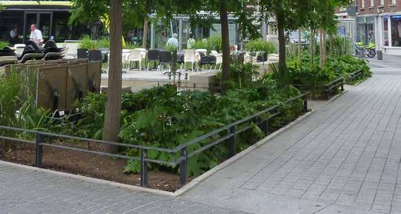
8 Ringsend Library Plaza - Focus Area 1 Korenmarkt Square - Belgium Sense of Place Continuity of materials, planting Reduction of street clutter Rationalising of street parking


9 Ringsend Library Plaza - Focus Area 1 Slowed traffic Plaza feel Controlled limited parking Traffic and Pedestrians separated Main Street, Chapelizod Village


10 Ringsend Library Plaza - Focus Area 1 Existing conditions Existing conditions Strong link between Library Plaza & Park Community Space with potential glazed link to library addressing the plaza and the retail units
11 Ringsend Park - Focus Area 2 Ringsend Village Improvement Plan

12 Ringsend Park - Focus Area 2 Problems: Need for lighting The Park fencing is generating a disconnect between the village and the Park Lack of strong connection between the park and adjoining sports facilities Potential: A safe, well lit park Introducing features for the more elderly members of the community A cohesive recreation and sports facility
13 Ringsend Park - Focus Area 2 Lighting to promote a sense of safety and security to the main circulation routes through the Park
14 Ringsend Park - Focus Area 2 Boundary treatment
15 Ringsend Park - Focus Area 2 Connecting Ringsend park with the village Open door policy considered Connecting the Stadium with the Park


16 Ringsend Park - Focus Area 2 Create connectivity between park and stadium Enhance entrances to park Lighting Enhance boundary Remove railing Broaden path, consider change in material, bring path into park


17 Ringsend Park - Focus Area 2 Broad, well lit circulation Open park boundaries Open park boundaries Clear gateways, in and out of park Broad pedestrian and cycle circulation


18 Ringsend Park - Focus Area 2 Existing conditions Removing this length of the railings and opening up the walk into the park


19 Ringsend Park - Focus Area 2 Create a strong threshold to the Park entrance Potential Private zone Public zone Intentions Taking away the carparking Enlarging the entrance Proposal open space Precidents


20 Ringsend Park - Focus Area 2 Existing Pigeon house Rd Potential Ringsend park - Narrow and dark entrance Cambridge Avenue - Enhancing the entrance - Stone clad sub-station visible Existing Conditions Ringsend Park entrance, Pigeon House Road


21 Ringsend Park - Focus Area 2 Existing Potential Ringsend park Ringsend park Pigeon house Rd - Narrow and hidden entrance - Moving the entrance on the main street Existing Conditions Ringsend Park entrance, Cambridge Road


22 Ringsend Park - Focus Area 2 Ringsend park Seating steps Bleachers Rationalizing the parking bay Ringsend park Connection Park / Irishtown Stadium Connection Park / Strand Street

23 Cycle & Pedestrian Links - Focus Area 3 Enhance Link to the Point Village & East Wall Community and on into the City Centre Improve connections to Hanover Quay & Grand Canal Dock Issues Links already exists Lacking Structure No Continuity Lacking direction / Way-Finding & Signage Ringsend Village Improvement Plan


24 Cycle & Pedestrian Links - Focus Area 3 Narrow path at East Link, conflict between pedestrians and cyclists. Clutter, temporary solutions Street clutter throughout No end goal in sight Narrow street, conflicts between pedestrians, cyclists and traffic


25 Cycle & Pedestrian Links - Focus Area 3 Strong, legible cycle and pedestrian connections Way Finding through lighting, street furniture, materials, planting and signage


26 Cycle & Pedestrian Links - Focus Area 3 Existing pocket parks not connected 1 2 Damaged lawn Enclosed spaces by fences and gates Narrow street by unauthorised carparking Cycle lane between 2 carparking Pointless connection


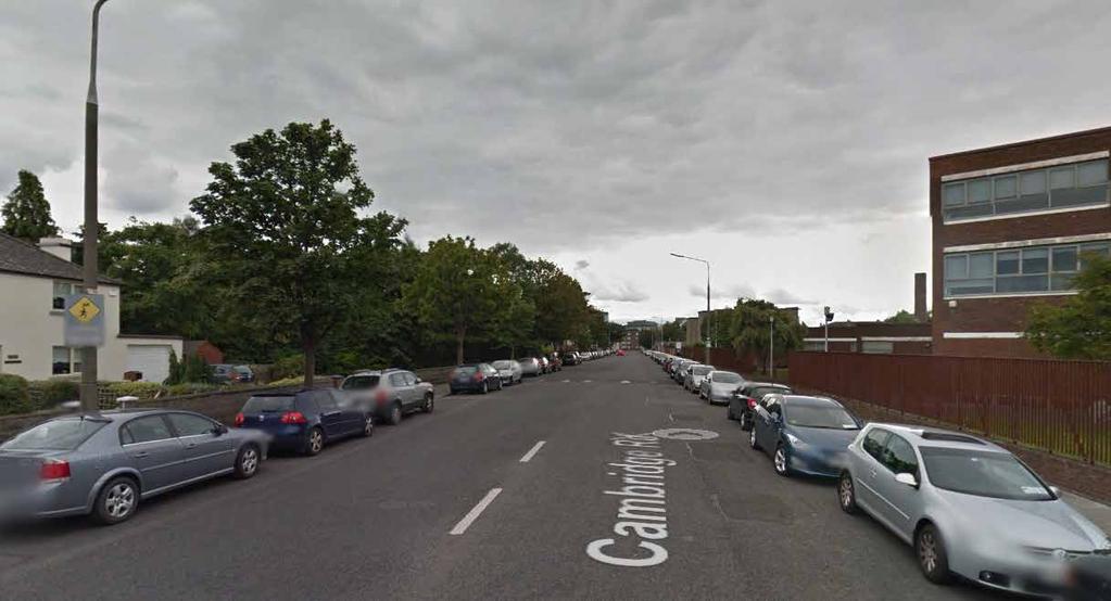
27 Cycle & Pedestrian Links - Focus Area 3 R 131 Potential > A large park along the quay > A gateway to Ringsend village Precidents Thorncastle st York Rd Existing Conditions
28 Cambridge Road - Focus Area 4

29 Cambridge Road - Focus Area 4 Problems: Width of street There currently appears to be a disconnect between the residential side of the street & the educational facilities Confusing junction Potential: Unifying Cambridge Road Cambridge Road has a wide range of architectural styles so the inclusion of large scale street trees could help to unify the street. The junction of York Road, Pigeon House Road and Cambridge Road is currently awkward & confusing. Rationalising of this junction should be considered.


30 Cambridge Road - Focus Area 4 Park entrance needs to be stregthened Road width too broad for location No structure to current car parking occurring Junction confusing and appears too large for the volumes of traffic Crossing from Park to Ringsend school can be enhanced


31 Cambridge Road - Focus Area 4 Existing Conditions Tree planted street
32 York Road & Pigeon House Road - Focus Area 5

33 York Road & Pigeon House Road - Focus Area 5 Problems: Parking Issues Poor definition to street / roads Lack of purpose to green space Clutter Potential: Rationalising parking and road layout along York Road and Pigeon House Road. Addressing the demand for parking in the Ringsend area Rationalising parking to the perimeter of Ringsend should free up parking in the centre Generate a homezone to create a street and sense a place


34 York Road & Pigeon House Road - Focus Area 5 Cars parked separating houses from the rest of the street Uncontrolled parking on grass verge Parking on both sides of street creates a narrow carriageway Limited number of designated parking spaces


35 York Road & Pigeon House Road - Focus Area 5 Pigeon house Road, ALTERNATIVE typologies Building frontage Buidling frontage Building frontage Planting border / Perpendicular carpark / crossing paving Planting border / paving perpendicular carpark Viewing the harbour : Seating area Existing Conditions

 Car park ( 6m )")
36 York Road & Pigeon House Road - Focus Area 5 Perpendicular parking spaces only on the left side to the road to keep a clear footpath Existing site - York Road Existing wall Planting Car park ( 5m ) Car park ( 6m ) Car park ( 2m )
37 Gateways - Focus Area 6 Problems: Undesignated & random parking on pavement areas Lack of structure or enclosure Potential: Create gateway element / spaces Provide structure to Parking Generate a purpose to the space Potential to provide outdoor seating space associated with the public house Connect the spaces to the adjacent retail units

38 Gateways - Focus Area 6 Uncontrolled car parking Street clutter


39 Gateways - Focus Area 6 Examples of outdoor seating area with planted boundary


40 Gateways - Focus Area 6 IRISHTOWN ROAD Reference Drawing attention, making active area Intentions Revitalising the square Retaining the desire lines Proposal Mixed public /private Extending the pub s terrace Relocating the car parking Proposal Whole public square Seating area and planting Filtering movement

41 Community Input & Comments Ringsend Village Improvement Plan
The Master Plan also identified a number of issues and these issues remain and if anything have become more acute since 1997.
 Ringsend AAP Introduction Dublin Docklands Area Master Plan (the Master Plan) identified a number, of areas within Docklands where more detailed planning would be appopriate. One of those areas is the
97 Lea Bridge Road, Leyton, E10 7QL London Borough of Waltham Forest December 2015
 97 Lea Bridge Road, Leyton, E10 7QL London Borough of Waltham Forest December 2015 Public Realm and Landscape Proposals LEA BRIDGE ROAD, WALTHAMSTOW Public Realm & Landscape Proposals BDP(90)RPT001 December
PUTTING THE HEART INTO BATTERSEA. A vision
 PUTTING THE HEART INTO BATTERSEA A vision INTRODUCTION This document is a vision for creating a Battersea that its community can be proud of and it is about putting Battersea on the map. It is being proposed
4. MASTERPLAN FRAMEWORK
 6a 6b 4. MASTERPLAN FRAMEWORK 6. Car Parks 6c Car Parks 6a and 6b will provide permanent parking. Area 6a will serve the foodstore with tarmac surfacing within a defined area to the west of the adjacent
East Grove Public Realm
 H - - MP - Elephant Park Public Realm RO EY DN NEW KENT ROAD E AC PL The public realm has been designed to create an environment which is easy to move through, accessible to all, safe and playful. The
Artists impression of the Park Promenade and plot H4 with café and restaurant uses that is still subject to change
 The Park Promenade Artists impression of how a café might look Artists impression of the Park Promenade and plot H4 with café and restaurant uses that is still subject to change Precedent images for balconies
5.0 P A R K R E C O M M E N D A T I O N S
 5.0 P A R K R E C O M M E N D A T I O N S 5.1 Confederation Park The analysis of Confederation Park recognizes that it, along with City Hall, is the symbolic heart of Kingston. While the existing layout
PROPOSED SITE IMPROVEMENTS
 PROPOSED SITE IMPROVEMETS This section is an excerpt from the San José City College Landscape Study - for use in reference to the Campus Facilities Committee Presentation, April, 0. B A D I H M H D K L
Docklands SDZ: Views & Prospects Analysis. Dublin City Council Planning Department February 2013
 Docklands SDZ: Views & Prospects Analysis Dublin City Council Planning Department February 2013 1.0 AIM OF STUDY The aim of the Views and Prospects study is to identify existing and potential views of
VEHICULAR AND PEDESTRIAN CIRCULATION
 This perspective sketch communicates the intended character and quality of a proposed streetscape design. Locate benches near a major intersection where people tend to gather. Seating and lighting provide
I615. Westgate Precinct
 I615. Westgate Precinct I615.1. Precinct Description The Westgate Precinct is located approximately 18km west of the Auckland city centre. There are seven Sub-precincts in the Westgate Precinct: Sub-precinct
EXISTING VEHICULAR & PEDESTRIAN CIRCULATION
 46 EXISTING CONDITIONS EXISTING VEHICULAR & PEDESTRIAN CIRCULATION Vehicular and pedestrian circulation patterns are illustrated on this graphic. Campus entry points and major vehicular circulation routes
To the Lord Mayor and Report No. 312/
 To the Lord Mayor and Report No. 312/2017 Members of Dublin City Council Report of the Chief Executive Dublin City Council -----------------------------------------------------------------------------------------------------------
Lancaster Conservation Area Appraisal. Character Area 8. Cathedral
 Lancaster Conservation Area Appraisal Character Area 8. Cathedral March 2013 118 3.8 Character Area 8. Cathedral 3.8.1. Definition of Special Interest "This character area is distinctive for the fine group
Westwind Developments Ltd. PIONEER LANDS AREA STRUCTURE PLAN - PROPOSED AMENDMENT
 FEBRUARY 2013 TABLE OF CONTENTS 1.0 BACKGROUND... 1 1.1 Amendment... 1 2.0 LOCATION & CONTEXT... 2 2.1 Land Ownership... 2 3.0 POLICY CONTEXT... 3 3.1 Municipal Development Plan... 3 3.2 Capital Region
Task Force on Kai Tak Harbourfront Development
 Task Force on Kai Tak Harbourfront Development For discussion on 29 March 2018 TFKT/04/2018 Study of Kai Tak Promenade Design Control and Guidelines Conceptual design scheme for Promenade at Runway Precinct
lot flankage Y street 16m 6m landscape strip for large site 3m landscape strip for small medium site
 Commercial General Commercial Objectives Create developments compatible with adjacent land uses in scale, function and character Define a consistent and attractive street edge with quality landscaping,
appendix and street interface guidelines
 appendix five: building and street interface guidelines appendix 5 building and street interface guidelines BOULEVARDS Boulevards are generally characterized by higher levels of traffic movement at higher
VILLAGE OF CHANNAHON COMMERCIAL DESIGN GUIDELINES. Village of Channahon S. Navajo Drive Channahon, IL (815)
") VILLAGE OF CHANNAHON COMMERCIAL DESIGN GUIDELINES Village of Channahon 24555 S. Navajo Drive Channahon, IL 60410 (815) 467-6644 www.channahon.org Adopted March 6, 2006 VILLAGE OF CHANNAHON COMMERCIAL DESIGN
VILLAGE OF CHANNAHON COMMERCIAL DESIGN GUIDELINES Village of Channahon 24555 S. Navajo Drive Channahon, IL 60410 (815) 467-6644 www.channahon.org Adopted March 6, 2006 VILLAGE OF CHANNAHON COMMERCIAL DESIGN
ROME WATERFRONT VILLAGE PROJECT NARRATIVE January 25, 2018
 January 25, 2018 The Rome Waterfront Village project is intended to foster the revitalization of the area between South James Street and Erie Boulevard north of the Erie Canal as well as improve public
Gas Stations ottawa.ca
 Urban Design Guidelines for Gas Stations ottawa.ca Ce document est disponible en français sur ottawa.ca. This document is available in French on ottawa.ca. Approved by City Council May 24, 2006 City of
F. Driveways. Driveways which provide access to off-street parking or loading from public streets shall comply with the following:
 Section 20.945.040 General Design Standards for Surface Parking Areas. A. Review Authority. Parking lot design and drainage shall be subject to review and approval of the City Transportation Manager. B.
EXISTING CONDITIONS 41. Existing Conditions
 EXISTING CONDITIONS 41 Existing Conditions The Existing Analysis phase of the planning process involved a study of the existing conditions on the campus in order to identify key planning issues to be addressed
Section 4 - Public Realm & Landscape proposals Landscape Masterplan. Section 4 52
 - Public Realm & Landscape proposals Landscape Masterplan 52 Proposed Masterplan - Green Infrastructure Strategy District Park 4.33 Ha to provide Passive and active recreation with a large play area which
GUIDELINES WESTON LOCATION: URBAN DESIGN GUIDELINES
 Development in the Weston area will be consistent with the following urban design guidelines. The guidelines correspond to Site and Area Specific Policies 45, 46, 47, 48, 49, 51, 52 and 232 in Chapter
UNIVERSITY TOWN NEIGHBOURHOODS 5.5 HOUSING MELBOURNE CAMPUS MASTER PLAN 2014
 5.5 169 EXISTING CONDITIONS & VISION NEIGHBOURHOOD VISION The provision of on-campus housing into the future will continue to be an important element of the La Trobe University experience. A long-term
PRELIMINARY DESIGN + DEVELOPMENT PLAN
 WELCOME! To The Public Open House May 30 th, 2017 HARBOUR WEST PARKS Vision Project Overview The City s vision for Port Credit Harbour West Parks is to develop a vibrant waterfront destination that integrates
PUBLIC RIGHT-OF-WAY IN THIS CHAPTER PUBLIC REALM
 PUBLIC RIGHT-OF-WAY This section provides design guidelines for improvements in the public right-of-way. The public right-of-way refers to streets, sidewalks, non-vehicular thoroughfares, parks and greenways
I404 Beachlands 2 Precinct
 I404. Beachlands 2 I404.1. Precinct Description The Beachlands 2 precinct covers approximately 6 hectares of land at the corner of Beachlands and Whitford Maraetai Roads. Its purpose is to provide for
Design Considerations
 Essential to the development of a successful Master Plan for the Park Complex is input from the community that the park will serve. The community outreach component of the planning process included numerous
PUBLIC REALM STUDY AREA
 WELCOME PUBLIC REALM STUDY AREA WHAT IS PUBLIC REALM? Welcome to the Ballina Town Public Realm public consultation event. Mayo Council is in the process of producing a Public Realm Strategy for Ballina
4.0 URBAN DESIGN FRAMEWORK. The vision for the future development of the plan area is to:
 4.0 The vision for the future development of the plan area is to: Create a new neighbourhood that focuses on the highly valued natural and aesthetic features of the lands and provides good quality homes,
Phase 1C. Phase 2B. Phase 1A. Phase 1B. Phasing. Lighting. Phase 2A. Staff House Project. Library Project. p p
 11 Phasing 12 Lighting Lighting will play a key role in the success of the Green Heart redevelopment. The various public spaces will be used a great deal after dark, and in particular during the busy winter
Chapter 2: OUTLINE PLANNING APPLICATION PROPOSALS. A New Garden Neighbourhood Matford Barton 17
 Chapter 2: OUTLINE PLANNING APPLICATION PROPOSALS A New Garden Neighbourhood Matford Barton 17 2.1. SUMMARY AND STATUS OF THE PROPOSALS 2.1.1. The parameter plans and associated wording in this chapter
Maplewood Avenue Downtown Complete Street Project
 Maplewood Avenue Downtown Complete Street Project Second Public Meeting January 24, 2018 Welcome and Introduction of Project Team City Planning and Public Works Staff City of Portsmouth Juliet Walker Planning
Wide asphalt driveway abutting school property. garage built with incompatible materials, too close to park. incompatible fencing materials
 Wide asphalt driveway abutting school property incompatible fencing materials garage built with incompatible materials, too close to park Lack of plantings as a buffer between private property and open
Urban Design Manual 2.0 DRIVE-THROUGH FACILITIES. Background. Urban Design Challenges
 222221 2.0 DRIVE-THROUGH FACILITIES Background In recent years, drive-through facilities have grown significantly in popularity with drive-through restaurants, in particular, being established on numerous
GREENFORD HALL & ADJOINING LAND
 GREENFORD HALL & ADJOINING LAND CONTENTS 1. Introduction 1. Introduction 2. Urban Context 2.1 The Site and Surroundings 2.2 Urban Context Map 2.3 Access and Movement 3. Planning Context 3.1 Planning History
Cleveland Park Streetscape and Drainage Improvement Project 1
 Cleveland Park Streetscape and Drainage Improvement Project 1 Urban Context Washington, D.C. Connecticut Avenue Cleveland Park Streetscape and Drainage Improvement Project 2 Neighborhood Context Contributing
VILLAGE OF SKOKIE Design Guidelines for Mixed-Use Districts NX Neighborhood Mixed-Use TX Transit Mixed-Use CX Core Mixed-Use
 VILLAGE OF SKOKIE Design Guidelines for Mixed-Use Districts NX Neighborhood Mixed-Use TX Transit Mixed-Use CX Core Mixed-Use TABLE OF CONTENTS CHAPTER 1 SITE DESIGN Purpose 1 CHAPTER 2 SITE DESIGN Streetscape
Chapter 4: Public Realm Strategy
 Chapter 4: Public Realm Strategy 4 Public Realm Strategy This Section details the Public Realm Strategy for the Town Centre required by Sections 6.2 (e) and 6.2 (g) of the Planning Scheme to address 'the
STREETSCAPE IMPROVEMENTS - RECOMMENDATIONS
 STREETSCAPE IMPROVEMENTS - RECOMMENDATIONS Figure 4.3.1- A map of all of the recommended streetscape improvements. The key component of downtown s public realm, apart from its public spaces, is its street
Urban Design Guidelines
 Urban Design Guidelines These Urban Design Guidelines comprise the Key Design Objectives below, the Roads Design Guidelines overleaf and Neighbourhood Framework Plans. Together with Section 3: Urban Design
Vision for East Cowes
 Vision for East Cowes A better East Cowes for now and the future The East Cowes Regeneration project is a major regeneration scheme on the Isle of Wight. It will create a vibrant community with a long-term
Area No. 1 Hornby North Zones B4, B5
 Area No. 1 Hornby North Zones B4, B5 Address: 27 Buchanans Road B4 Zone Activity/Office The office is located at the front of the building Location 5-6m, two storey Along full frontage but some areas of
Report or technical documentations of the target areas in Siauliai
 WP 4 Energy Supply Report or technical documentations of the target areas in Siauliai 2011.10.27 Summary of the draft version of technical documentation for two target areas Lieporiai park 1.1. Works basis
Official Community Plan Bylaw No. 4360, 2004, Amendment Bylaw No. 4897, 2016 (Sewell s Landing)
") District of West Vancouver Official Community Plan Bylaw No. 4360, 2004, Amendment Bylaw No. 4897, 2016 (Sewell s Landing) Effective Date: 1089612v1 District of West Vancouver Official Community Plan Bylaw
District of West Vancouver Official Community Plan Bylaw No. 4360, 2004, Amendment Bylaw No. 4897, 2016 (Sewell s Landing) Effective Date: 1089612v1 District of West Vancouver Official Community Plan Bylaw
Appendix D North Road/N. Leroy Street Subarea Plan
 North Road/N. Leroy Street Subarea Plan INTRODUCTION The City of Fenton Master Plan was updated in 1996 and included a subarea plan for the North Leroy Street area of the City. It was recognized at that
CITY CLERK. Consolidated Clause in North York Community Council Report 8, which was considered by City Council on October 26, 27 and 28, 2004.
 CITY CLERK Consolidated Clause in Report 8, which was considered by City Council on October 26, 27 and 28, 2004. 28 Request for Direction Report - Site Plan Approval Application 03 200020 NNY 24 SA - Marek
10 Proposed Redevelopment, Tewkesbury Road, Cheltenham SCHEME EVOLUTION STARBUCKS
 SCHEME EVOLUTION STARBUCKS The proposed Starbucks Drive Thru alongside the proposed food store provides an appropriate mix of uses, suitable for this location. The proposed store is bespoke, designed specifically
Appendix 2 Waterbeach Greenway Review
 Appendix 2 Waterbeach Greenway Review Nigel Brigham & Associates A report for 1 Introduction This report is based on fieldwork carried out in 2016 to review the Greenway network around Cambridge as shown
The Village. Chapter 3. Mixed Use Development Plan SPECIFIC PLAN
 The Village SPECIFIC PLAN Chapter 3 3.1 INTRODUCTION 3.1.1 Purpose This Chapter describes the development regulations applicable to the Mixed-Use and Transit Center Planning Areas. These form-based regulations
25 Crime Prevention through Environmental Design (CPTED)
") Volume 2: Assessment of Environmental Effects 412 25 Crime Prevention through Environmental Design (CPTED) Overview The purpose of this Chapter is to provide a Crime Prevention Through Environmental Design
Volume 2: Assessment of Environmental Effects 412 25 Crime Prevention through Environmental Design (CPTED) Overview The purpose of this Chapter is to provide a Crime Prevention Through Environmental Design
RZC Public View Corridors and Gateways
 RZC 21.42 Public View Corridors and Gateways 21.42.010 Purpose 21.42.020 Scope and Authority 21.42.030 Administration 21.42.040 Gateways Design 21.42.050 Unidentified Public Views 21.42.060 Identification
The eight-week period for this application expires on 5 October 2006.
 06/01213/FUL CHANGE OF USE FROM AGRICULTURAL LAND TO PRIVATE CAR PARK AND NEW FENCING. AT Land To The South of Perceval Almhouses, Lower Weald, Calverton FOR Calverton Parochial Church Council INTRODUCTION
Cross City Cycling Ditton Lane and Links to East Cambridge Proposed FDPC Response to Consultation for agreement FDPC meeting Feb 2 nd
 Cross City Cycling Ditton Lane and Links to East Cambridge Proposed FDPC Response to Consultation for agreement FDPC meeting Feb 2 nd NB Outcome of public consultation received up to and incld. Feb 2nd
MEMORANDUM. This memo deals with proposed amendments to previously issued Development Permit No for Park Royal North.
 MEMORANDUM Date: August 28, 2015 Our File: 1010-20-15-062 To: Design Review Committee From: Lisa Berg, Senior Community Planner Re: Amendment to Development Permit for Park Royal North This memo deals
OPTIONS QUESTIONNAIRE
 OPTIONS QUESTIONNAIRE Mark the Yes column for each statement that you agree with Mark the No column for each statement that you disagree with Please complete all the statements if possible. Please add
6 Site Framework Strategies
 6 Site Framework Strategies 6.1 Introduction Section 6 identifies a number of specific areas which are considered to be key sites within the Plan area and which may have potential for development / redevelopment.
WEST LOOP DESIGN GUIDELINES CHECKLIST
 WEST LOOP DESIGN GUIDELINES CHECKLIST Section 1.0 General Strategies 1.1 DESIGN EXCELLENCE: ENCOURAGE HIGH QUALITY AND INNOVATIVE DESIGN OF NEW BUILDINGS WITHIN THE WEST LOOP WITHOUT BEING PRESCRIPTIVE
BUSINESS DISTRICT DESIGN GUIDELINES
 Des Plaines, Illinois Prepared for the City of Des Plaines by: The Lakota Group Laurie Marston, AICP March 2005 Section 5: Streetscape Elements Business District Design Guidelines STREETSCAPE ELEMENTS
3.1 Streetscape Overview
 3.0 Streetscape 3.1 Streetscape Overview Existing streetscape There are four main elements within the streetscape, these include: street lighting, surfacing, street furniture, street trees and planting.
Carlsbad Village Redevelopment Concept Summary of Features
 Carlsbad Village Redevelopment Concept Summary of Features Calthorpe Associates November 5, 2003 The Redevelopment Concept illustrates a vision for the future of Carlsbad Village. The overall vision of
Nelson Residential Street Frontage Guideline
 DRAFT 22-06-2012 Nelson Residential Street Frontage Guideline June 2012 1317273 Contents and purpose Residential s are important Residential s are much more than corridors which move traffic. Streets allow
/05 Architectural Response
 /05 Architectural Response 5.1 Inspiration Stacked Boxes (Artist : Rachael Whiteread) Cubism ( Architect : Le Corbusier) 52 1133 Melville Rezoning Submission Patterns ( Textile Artist : Annie Albers) Overlapping
Woodbrook - Shanganagh
 Section 4: Key Sites Framework Strategy Woodbrook - Shanganagh Local Area Plan 2017-2023 4. Site Framework Strategies The Master Plans shall have regard to the thematic objectives under the LAP Development
LAKESHORE EAST - IJKL
 LAKESHORE EAST - SECOND COMMUNITY MEETING 9 AUGUST 08 RIVERWA LK LEVEL) (INTERMEDIATE COLUMBUS DR CHICAGO E WACKER HYATT REGENCY I CHICAGO RIVER NAVY PIER CHICAGO RIVE RWALK DR (UPP ER LEVEL RIVER GATEWAY
1. General Purpose. 3. Uses
 1. General Purpose The purpose of this DC1 Provision is to facilitate the development of a pedestrian friendly Community Commercial Centre that may accommodate a range of commercial, residential, office,
Courthouse Square Planning & Urban Design Study. Courthouse Square Working Group #13 October 15, 2014
 Courthouse Square Planning & Urban Design Study Courthouse Square Working Group #13 October 15, 2014 1 Courthouse Square Process Working Group Community Courthouse Square Advisory Groups & Civic Associations
CHAPTER 20: INSTITUTIONAL USE DEVELOPMENT STANDARDS
 CHAPTER 20: INSTITUTIONAL USE DEVELOPMENT STANDARDS ARTICLE 1: GENERAL INSTITUTIONAL USE STANDARDS 320-01. Application The provisions of this Chapter shall apply to the following uses in any zone: (e)
The open space system should provide connective elements, relate to natural resources, and enhance the suburban character of the landscape..
 The open space system should provide connective elements, relate to natural resources, and enhance the suburban character of the landscape.. Mixed-use and infill development should maintain or enhance
public spaces and associated development
 4.0 Public Spaces and Associated Development The Guinness lands are adjacent to 3 of the principal public spaces of the Development Framework Plan for the Heuston Gateway as described below. 4.1 Heuston
WINDSOR GLEN DESIGN GUIDELINES
 WINDSOR GLEN DESIGN GUIDELINES Adopted by Council, 2006 WINDSOR GLEN REDEVELOPMENT DESIGN GUIDELINES August 2006 1.0 Master Plan Organization For this area of the Coquitlam Town Centre, a mix of high,
Carmel College Development
 Carmel College Development Planning Application Ref: P11/W2357 Planning Objections Introduction and Summary A formal planning application has finally been submitted The proposal is for 166 properties (flats
edge of gas line corridor setback edge of gas line corridor aligned with Schlumberger building 37.0 m AOD 33.0 m AOD max
 7. Heights and Street Frontage: In accordance with the approved heights parameters, heights to along Western Access Road must respond to the existing low density character in this location. Heights are
City of Redlands Architectural Guidelines for Non-Residential Development
 14. Building articulation shall be included in the design of building, in order to create a formal entry statement. Avoid this Do this Page 11 15. Give special attention to creating pedestrian scale and
Appendix H: Easement cross sections
 Appendix H: Easement cross sections SHARED PATH 1.5m FOOTPATH NATURE STRIP 7.3m CARRIAGEWAY 2.7m NATURE STRIP EXISTING PIPELINE 150mm DIA 5.0m (approx.) LOCAL ACCESS ROAD EXISTING PIPELINE 500mm DIA 2.7m
6.0 Access & Maintenance
 Design and Access Statement April 2017 125 6.1 Inclusive Design - Site This proposal has been designed with consideration of the principles of inclusive design, as to be as inclusive as possible including
New-Cast Mixed-use Development Proposal King Street West, Newcastle, Ontario
 URBAN DESIGN BRIEF New-Cast Mixed-use Development Proposal King Street West, Newcastle, Ontario TABLE OF CONTENTS: 1.0 Executive Summary 2.0 Creating Vibrant and Sustainable Urban Places: Excerpts from
3.2 EXISTING LAND USE. Landscape & Urban Design Framework
 3.2 EXISTING LAND USE Landscape & Urban Design Framework 26 3.2 EXISTING LAND OWNERSHIP 27 Poolbeg Awakens 3.3 PLOTS CONSIDERED WITHIN PLANNING BOUNDARY plots within Planning Scheme Boundary Landscape
POTTERSPURY PARISH COUNCIL Grass Mowing and Tree & Shrub Maintenance Tender 2017
 SPECIFICATION 1. GENERAL MOWING: To mow to the satisfaction of the Parish Council the areas marked on the maps being: 1.1. Verges throughout the village including the vision splays in front of all four
BENJAMIN BANNEKER PARK FRAMEWORK PLAN (PLAN ADOPTION)
") BENJAMIN BANNEKER PARK FRAMEWORK PLAN (PLAN ADOPTION) COUNTY BOARD MEETING DECEMBER 16, 2017 County Board Consideration: Adopt the Benjamin Banneker Park Framework Plan and Design Guidelines Framework
BENJAMIN BANNEKER PARK FRAMEWORK PLAN (PLAN ADOPTION) COUNTY BOARD MEETING DECEMBER 16, 2017 County Board Consideration: Adopt the Benjamin Banneker Park Framework Plan and Design Guidelines Framework
Main Street Conversion Site
 Main Street Conversion Site Borough of Brooklyn, New York Preliminary Presentation Park Expansion Design & Development Committee 13 September 2012 Michael Van Valkenburgh Associates, Inc. Landscape Architects,
PART I-D BUFFERS AND LANDSCAPING REQUIREMENTS
 District Regulations Of General Applicability ARTICLE IX PART I-D BUFFERS AND LANDSCAPING REQUIREMENTS 9-107 BUFFERS AND LANDSCAPING 9-107 A. General Landscaping and Maintenance Requirements. Except for
Proposals for a new college and homes. Thank you for visiting our exhibition.
 1 Welcome Thank you for visiting our exhibition. The college are pleased to welcome you to view our plans to regenerate. If you have any questions, please feel free to speak with a member of the project
15 Urban Design Guidelines
 15 Urban Design Guidelines Aim: To create vibrant and bustling towns and villages with a diverse mix of activities where residents can benefit from quality urban living. 15.1 Background Through the planning
development framework plan
 3.2.1.1 Phoenix Park to Royal Hospital Kilmainham The Phoenix Park and Royal Hospital Kilmainham Park have been separated since the construction of the Heuston Station in the mid 1800s. Consequently both
Site 2 Development Brief
 a South Marketgait Site 2 b Union Street c Site 2 Development Brief Thomson Avenue (Northern Boulevard) Dundee Riverside Drive Discovery Plaza South Union Street Station Earl Grey Place West Site 5 Site
4.0 Open Space and Laneways
 4.0 Open Space and Laneways 4.1 Open Space Overview Existing open space network Currently there is a lack of public open space in the CBD - the only formal public space is Wachner Place, which is not functioning
Sunday's Well Proposed Architectural Conservation Area
 1 Sunday's Well Proposed Architectural Conservation Area D A E C B F Old City Gaol Saint Vincent s RC Church Saint Albert s Former Good Shepherd Convent Boundary of Area Sunday's Well is an area located
Site 5 Development Brief
 Union Street Crichton Street South Crichton Street Thomson Avenue (Northern Boulevard) Site 5 South Union Street Earl Grey Place West Site 6 Riverside Esplanade (Southern Boulevard) South Crichton Street
PROPOSED REDEVELOPMENT OF THE GLEN ABBEY GOLF CLUB. STREETSCAPE DESIGN STUDY (excerpt from the Urban Design Brief) TOWN OF OAKVILLE.
 TOWN OF OAKVILLE.") PROPOSED REDEVELOPMENT OF THE GLEN ABBEY GOLF CLUB STREETSCAPE DESIGN STUDY (excerpt from the Urban Design Brief) TOWN OF OAKVILLE OCTOBER, 2016 for 2.4.2 STREETS Streets are the single largest component
PROPOSED REDEVELOPMENT OF THE GLEN ABBEY GOLF CLUB STREETSCAPE DESIGN STUDY (excerpt from the Urban Design Brief) TOWN OF OAKVILLE OCTOBER, 2016 for 2.4.2 STREETS Streets are the single largest component
CITY OF KEIZER MASTER PLAN APPLICATION & INFORMATION SHEET
 CITY OF KEIZER MASTER PLAN APPLICATION & INFORMATION SHEET PRE-APPLICATION CONFERENCE Prior to the actual filing of a Master Plan application, it is strongly recommended that the applicant contact Planning
DESIGN PARAMETERS DESIGN OBJECTIVES. Design Focus and the Elements of the Corridor. Driver Confidence. Visual Organization.
 Design Focus and the Elements of the Corridor LBJ Corridor DESIGN PARAMETERS For any project to be successful, the project goals must be clear. Therefore, with the assistance of TxDOT, the Urban Design
What do you like about South Marston?
 What do you like about South Marston? What you have said so far: Strong and separate identity, distinct from Swindon Village character (Church, School, Green and Hall) Surrounding working countryside and
The Vision. Photo provided by The Minervini Group. 46 Vision, Objectives & Strategies
 Vision, Objectives & Strategies The is the public framework and guide for future development of the Grand Traverse Commons. The establishes public polices for infrastructure, the preservation of natural
The Project. In 2013, construction was completed between 100 Street and 102 Street.
 The Project Jasper Avenue New Vision (JANV) is a major catalyst project identified in the Capital City Downtown Plan (2010) between 92 Street and 109 Street, including the streets half a block north and
2.5 Roads. Loading and service areas adjacent to Highway 401 should be screened through architectural walls and/or landscape buffer planting.
 N HIGHWAY OFF RAMP 2.5 Roads A legible road network with a clear hierarchy will help create a connected community, both within and surrounding the Milton Heights. The following section outlines the proposed
R STREET CORRIDOR NEIGHBORHOOD Site Plan and Design Review Supplemental Guidelines Checklist
 R STREET CORRIDOR NEIGHBORHOOD Site Plan and Design Review Supplemental Guidelines Checklist Applicant s Name: Project Address: Phone: Email: Applicant shall fill out the design guidelines checklist for
West Blackhall Street Public Realm Public Exhibition
 West Blackhall Street Public Realm Public Exhibition Welcome Introduction Thank you for coming to this public engagement, your input is sought to help to deliver high quality public realm improvements