NORTH WEST LEEDS COUNTRY PARK AND GREEN GATEWAYS PROJECT. Country Parks Officer Douglas Louis
|
|
|
- Phillip Maxwell
- 5 years ago
- Views:
Transcription
1 NORTH WEST LEEDS COUNTRY PARK AND GREEN GATEWAYS PROJECT Country Parks Officer Douglas Louis
2 Vision To Preserve, Improve and Promote Green Spaces and their Connectivity for People & Wildlife in North West Leeds
3 Today A Concept Tomorrow A Reality Now Isolated green spaces and P&C land joined by Rights of Way Future Continuous area of publicly accessible green space from the city centre to the wider countryside
4 Main Focus on existing Leeds Parks and Countryside Land The less formally managed areas of value to people and wildlife eg community parks, local green area, woodlands But, will include other land which shares the Vision for the NW Leeds Country park eg semi-natural green space, Leeds nature areas and sites of ecological or geological importance.

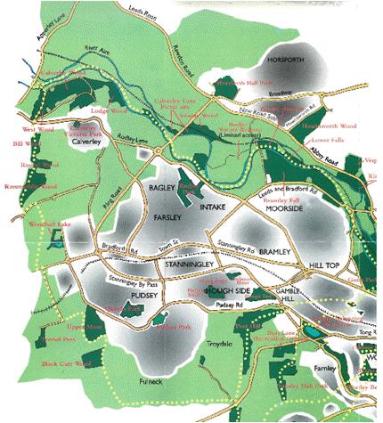
5 Boundary of the Northwest Leeds Country Park and Green Gateways project North Yorkshire boundary Aireborough River Aire


6 Definition of a Green Space? Green Infrastructure/Green Corridors/Green Belt Sports pitches Nature reserves Public parks Road verges/hedgerows/street trees Railway embankments Rivers/canals/becks/lakes Farmland and other private land Brownfield Footpaths/cycleways/ towpaths Cemeteries Allotments Green roofs on buildings Many different definitions, designations and classifications!
7 Category City Park Country Park Community Park Recreation Ground Local Green Space Woodlands Cemeteries, disused churchyards and other burial grounds Allotments Outdoor Sports Facilities Provision for children & young Public Rights of Way Leeds Parks & Countryside Definition Attract local urban communities and visitors from a wider catchment area Attract local village communities and visitors from a wider catchment area (in Green Belt area) Serve surrounding local communities (800m catchment) Allows formal and informal recreation and often contains playing pitches and play areas (400m catchment) Opportunities for informal activities close to home or work or enhancement of the appearance of residential or other areas (200m catchment) As above but predominantly woodland Places for quiet contemplation and burial Opportunities for those wishing to grow their own produce Tennis courts, bowling greens, golf courses, sports pitches, school playing fields etc. Play areas, skateboard parks, basketball, teenage shelters Access routes for walking, cycling and horseriding providing a means to link parks and green spaces etc.
8 Category No. & Size in Leeds (P&C responsibility) No. in NW Leeds Country Park & G.G. Project Area City Park 4 740Ha. 1 Kirkstall Abbey Estate Country Park 3 277Ha. 2 Chevin Forest Park, Golden Acre Park Community Park Ha. 15 e.g. Grove Hill Park, Holt Park, Horsforth Hall Park, Kirk Lane Park, Micklefield Park, Nunroyd Park, Yeadon Tarn, The Hollies, Wharfemeadows Park Recreation Ground Ha. 15 e.g. Bedquilts Rec. Ground, Butcher Hill Playing Fields, Tinshill Rec. Ground, West Park Playing Fields Local Green Space Ha. 61 e.g. Engine Fields, Disused Railway off Bradford Road, Hanover Square, Holt Lane POS, Springfield Park Woodland Ha. 28 e.g. Eccup Whin, Clayton Wood, Hunger Hills, Ireland Wood, Morris Wood Cemeteries, disused churchyards, burial grounds Ha. 8 e.g. Yeadon Cem., Rawdon Crem., Lawnswood Cem/Crem., Guiseley Cem. Allotments 99 95Ha. 14 e.g. Crowtrees allots., Burley Model allots. Outdoor Sports Facilities 482 N/A TBC Provision for children/young 201 N/A TBC Public Rights of Way 814km TBC
9 Aim 1. Preserving Green Spaces Keep the green spaces that already exists Parks & Countryside Land Adequately Preserved Non LCC Land Liaison with planning services and private landowners (PPG17 & Natural Enviroment White Paper
10 Aim 2. Improving the Quality of Green Spaces Balance the competing demands of people and wildlife Use SWOT Analysis of internal Leeds quality park assessments based on Green Flag Criteria. Welcoming Place Healthy, Safe and Secure Well maintained and Clean Sustainability Conservation and Heritage Features Community Involvement Marketing Management Strengths Opportunities Weaknesses Threats
11 Works Programme & Funding Leeds Quality Parks Assessment Central and Local Government strategies, policies and statutory obligations Consultation with local community groups SWOT Analysis List of works required Seek funding
12 Problems & Solutions for Green Space Quality Problems Fly-tipping and other rubbish Site vandalism and graffiti Ineffectual or lack of management for wildlife Little or no information on features of interest Path network, seating or entrance features Sense of connection to or responsibility for the green space from local community Solutions Erect entrance signage with green space name and LCC contact details Work with community groups to help clean up the green space and secure funding for path/wildlife/history improvement proj
13 Aim 3. Promoting Green Spaces a) Promote the positive role of the connection between green space and wildlife quality of life a) Encourage local people to discover the green spaces on their doorstep
14 a) Attempts to re-connecting people and wildlife Natural England s ANGSt Model Leeds City Council Core Strategy
15 Natural England ANGSt Model (Accessible Natural Greenspace Standards) Provision of Natural Green Space based on scientific research - led to Size and Distance criteria: No person should live more than 300m from their nearest area of natural greenspace of at least 2Ha. At least 1Ha. of Local Nature Reserve per 1000 population At least one accessible 20Ha. natural greenspace within 2km of home One accessible 100Ha. natural greenspace within 5km of home One accessible 500Ha. natural greenspace within 10km of home
16 Assess the impact of applying the Accessible Natural Green Space Standards criteria in NW Leeds When applying the standards we must remember the three underlying principles of ANGSt which are: - Improving access to greenspace Improving naturalness of greenspaces Improving connectivity with greenspaces Then other factors come into play: - Consider if we can meet it through existing land (both P&C and non- LCC) i.e. by changing how that land is managed Will new land be needed to address areas of deficit in natural green space provision
17 b) Discover Green Spaces Instead of just promoting the green spaces in isolation from each other identify a walking route or trail that connects them. This Trail project will promote isolated green spaces and the Rights of Way that connects them The main Right of Way route will be known as the NW Leeds Country Park & Green Gateway trail- 43 miles circular. However, this is of limited use to many people who just want easy access to local walks. Therefore, we will be encouraging areas to map out local circular walking routes in their area that connect to the main 43 mile trail. All the walks will then go into a series of leaflets
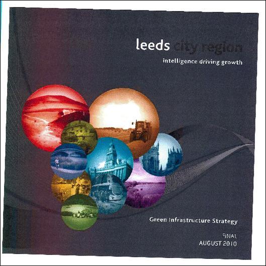
18 The Red Line of NW Leeds Trail


19 Local Walk & Leaflet
20 Project Issue Natural England have a green infrastructure mapping project which has been taken into a strategy for Leeds City Region and Leeds (LDA Design 2009/ ) However, the Leeds Core Strategy 2014 has not represented this adequately in its documents. This needs picking up in Neighbourhood Plans. Comment added by Aireborough Neighbourhood Development Forum following discussion on the project and analysis of sustainability aspects of the site allocation plan
21 Natural England s Green Infrastructure Mapping Project to help local authorities protect and create green infrastructure through their Local Development Frameworks (LDFs) Natural England worked in partnership with all local authorities in the region as well as other partners to ensure a consistent approach was taken to green infrastructure mapping Natural England is keen to see this evidence used to support projects and policy at both strategic and local levels. It has already been used by Leeds City Region to inform the Green Infrastructure Strategy for the Leeds City Region and also by Leeds City Council in their Core strategy: Leeds Local Development Framework and enter green infrastructure
22

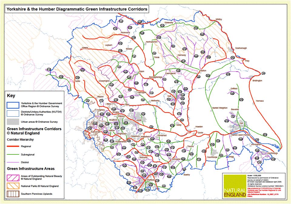
23 Main Green Infrastructure Corridors - NW Leeds
24
25 Green Infrastructure Strategy for the Leeds City Region Traditionally, environmental planning has looked at the functions of green infrastructure in isolation, such as biodiversity, open space provision or public realm design.. a green infrastructure approach considers how together these assets form an overall system. at the local level, using green corridors to link new settlements with existing green infrastructure assets has the potential to transform the prosperity and health of a community. Similarly, linking isolated habitats can help maintain populations of rare or threatened species by increasing their resilience to change.


26 Leeds Core Strategy Poorly Mapped Infrastructure
27 Making it Happen Key Partners Planning Services Increased pressure on the green spaces? Recognition of the Country Park concept and its underlying aim to meet the ANGSt criteria Seek opportunities for improvements to quality and better connectivity through Community Infrastructure Levy?
28 Key Partners Landowners To open up new land to public access or promote existing access more widely for example: Create the definite right of way linking East Busk Lane to the footpath that goes under the disused railway bridge to secure the NWLCP&GG trail
29 Key Partners Local Community Groups Help preserve the local green spaces that are important to them and help identify works required Lead external funding bids (with P&C support)
30 Key Partners External Bodies Conservation Volunteers & Groundwork experts working with community groups Healthy Walking initiatives leaflets in GP surgeries and local libraries EA, Natural England & Yorkshire Wildlife Trust, Buglife wildlife corridors & waterways projects Universities a big part of the local community and landowner
31 Plan Priority Put the NW Leeds Country Park & Green Gateway trail and local routes connecting the green spaces ON THE MAP Make the trail a reality and the next stage of physically connecting the green spaces will be easier to work towards One or Two local community groups are needed to jointly fund a bid forreating the NW Leeds Country Park & Green Gateway trail and local routes Funding for signposting the NWLCP&GG trail, leaflets, podcast, some interpretation panels - and installing these signs/posts
32 My present role Secure funding for NW Leeds Country Park & Green Gateway trail Management Plan & SWOT Analysis Help identify the main projects needing external funding per P&C green space site so there is a list of opportunities awaiting funding
Neighbourhood Planning Local Green Spaces
 Neighbourhood Planning Local Green Spaces Introduction... 2 1. Why green space is important... 4 2. Neighbourhood plans and green space... 6 3. Evidence... 8 Statutory designations... 9 Green space audit...
Wildlife and Planning Guidance: Neighbourhood Plans
 Wildlife and Planning Guidance: Neighbourhood Plans This Leaflet is one of a series of 4 Wildlife and Planning Guidance Leaflets and is intended to provide useful information to assist you to campaign
Sankey Valley Corridor Enhancement Project Green Infrastructure data Biodiversity and ground nesting bird habitat
 Sankey Valley Corridor Enhancement Project Green Infrastructure data Biodiversity and ground nesting bird habitat Introduction Sankey Valley is a key environmental and economic corridor; it runs through
SITE ALLOCATION PLAN FEEDBACK HG2-10 Gill Lane, Formerly Site 1221
 SITE ALLOCATION PLAN FEEDBACK HG2-10 Gill Lane, Formerly Site 1221 My Response Nigel Wilson Chairman, Nether Yeadon Conservation Area 24 Gill Lane Nether Yeadon, LS19 7DD NTWILSON@OUTLOOK.COM I wish to
Park Development Framework Area Proposals. Context to Area 2 Ruckholt Road to Coppermill Lane
 Park Development Framework Area Proposals Context to Area 2 Ruckholt Road to Coppermill Lane The defining feature of this area is the broad expanse of marshlands. These provide the context for a diverse
Aireborough. 12 Larkfield Drive (off) - Ivy House (adjacent), Rawdon. Site Details. Site Characteristics. Major Settlement Infill Aireborough
 - Ivy House (adjacent), Rawdon. Site Details. Site Characteristics. Major Settlement Infill Aireborough") 12 Larkfield Drive (off) - Ivy House (adjacent), Rawdon Site Details Easting 421124 rthing 439489 Site area ha 0.5 SP7 Major Settlement Infill HMCA Aireborough Ward Guiseley and Rawdon Site Characteristics
12 Larkfield Drive (off) - Ivy House (adjacent), Rawdon Site Details Easting 421124 rthing 439489 Site area ha 0.5 SP7 Major Settlement Infill HMCA Aireborough Ward Guiseley and Rawdon Site Characteristics
The Gwennap Parish Vision Statement
 QUICK GUIDE What is a Neighbourhood Development Plan? Ultimately it is a document used by developers or anyone wishing to submit a planning application that describes the vision, strategy, plans, regeneration,
Neighbourhood Planning Guidance Local Green Spaces
 Neighbourhood Planning Guidance Local Green Spaces Introduction This guidance note has been produced for communities preparing neighbourhood plans in North Dorset to help them to identify, assess and designate
8.0 Design and Form of Development 43/
 42/ 8.0 Design and Form of Development 43/ Rothwells Farm, Golborne/ Development Statement Figure 7. Site Constraints Key 44/ Site Boundary 360 Bus Route/Stops Existing Trees Underground Water Pipe Sensitive
The journey so far. The new masterplan for Dargavel Village
 The journey so far Our vision for Dargavel Village began over ten years ago when the original masterplan for transforming the former Royal Ordnance Factory site into a thriving community was established.
Statutory and Non-Statutory Designated Sites and Ecology
 Statutory and Non-Statutory Designated Sites and Ecology The National Planning Policy Framework considers the conservation and enhancement of the natural environment in chapter 11 paragraphs 109-119, where
Kibworth Harcourt. Introduction. Introduction
 Introduction Introduction Welcome to this public exhibition on the proposals for the delivery of new homes on land at The Kibworths. The purpose of today s exhibition is to give you the opportunity to
Making Space for Nature A Leicester Case Study. Dr Helen O Brien Leicester City Council
 Making Space for Nature A Leicester Case Study Dr Helen O Brien Leicester City Council Helen.Obrien@Leicester.gov.uk Definitions Biodiversity (biological diversity) The variety of plant and animal life
Site Assessment Technical Document Appendix A: Glossary
 Central Bedfordshire Council www.centralbedfordshire.gov.uk Site Assessment Technical Document Appendix A: Glossary July 2017 1.1.11-1 - ii Appendix A: Glossary Term Agricultural Land Classification AONB
Elderberry Walk. Developer HAB Housing
 Case studies Elderberry Walk Developer HAB Housing Development of 161 new homes on the former Dunmail Primary School site, focused around a central green street, with retained trees, new multifunctional
Welcome to our exhibition
 Welcome to our exhibition The Homes & Communities Agency (HCA) welcomes you to this public exhibition explaining our proposals for the redevelopment of the former Lea Castle Hospital site. About the Homes
9 Pershore. Introduction. Pershore Abbey
 118 Introduction 9.1 The historic town of Pershore lies on the River Avon and has a population of 7,000 (2009 Mid-Term Population Estimates). The main areas of the town are centred on the Abbey, the bustling
GREEN INFRASTRUCTURE PLANNING GUIDE
 GREEN INFRASTRUCTURE PLANNING GUIDE Authors: C Davies, R MacFarlane, C McGloin, MRoe. Abbreviation Green Infrastructure is frequently abbreviated to as GI and Green Infrastructure Planning as GIP. Contents
Weaver Valley Green Infrastructure data
 Weaver Valley Green Infrastructure data Introduction Introduction Green infrastructure is a 150m 1 asset that we propose can be better used to provide competitive advantage and underpin sustainable growth
Local Wildlife Sites in Leicestershire and Rutland
 Local Wildlife Sites in Leicestershire and Rutland What are Local Wildlife Sites? From mystical ancient woodlands to quiet churchyards and bustling flower-rich roadsides; and from field-bordering hedgerows
Linby Neighbourhood Plan Masterplan Safeguarded Land Top Wighay Farm March Linby Neighbourhood Development Plan Masterplan 1
 Linby Neighbourhood Plan Masterplan Safeguarded Land Top Wighay Farm March 2017 Linby Neighbourhood Development Plan Masterplan 1 Linby Neighbourhood Development Plan Masterplan 2 Contents: Section 1:
Wildlife and Planning Guidance: Local Plans
 Wildlife and Planning Guidance: Local Plans This Leaflet is one of a series of 4 Wildlife and Planning Guidance Leaflets and is intended to provide useful information to assist you to campaign effectively
Droitwich Spa 6. Reasoned Justification
 87 Droitwich Spa 6 Reasoned Justification 6.1 Droitwich Spa is identified in the settlement hierarchy (Policy SWDP1) as a main town being the largest settlement in Wychavon District with an estimated population
Green Infrastructure planning must be evidence led, thus the importance of this stage in collating your information and responses.
 Green Infrastructure Consultation Proforma Recipients: Andy Maginnis (Countryside Services) regarding access, recreation and tourism Ed Dursley (Transport) regarding access and movement Steve Bloomfield
3. Neighbourhood Plans and Strategic Environmental Assessment
 1. Introduction This report sets out a draft Screening Determination for the Preston Parish Council s Neighbourhood Plan and has been prepared by rth Hertfordshire District Council. The purpose of the
Welford-on-Avon Neighbourhood Plan Consultation Event Sunday, 6 April Your name Your address
 Welford-on-Avon Neighbourhood Plan Consultation Event Sunday, 6 April 2014 Your name Your email address Please either: - complete this feedback form and put it in the box before leaving the Memorial Hall
Briefing Document of CNP. June 2017
 Cholsey Parish Council Cholsey Neighbourhood Plan Briefing Document of CNP June 2017 Cholsey Neighbourhood Plan Page! 1 of! 8 Cholsey Plan Briefing v1.4 Page Left Intentionally Blank Cholsey Neighbourhood
1.3 The following table presents a Statement of Compliance demonstrating how the Standish Neighbourhood Plan meets those requirements.
 1. Introduction 1.1 This Basic Condition Statement was prepared to accompany the draft Standish Neighbourhood Plan (2018). 1.2 Paragraph 8 of Schedule 4B of the Town and Country Planning Act 1990 requires
Richard Lemon Spatial Project Manager. Biodiversity and Green Infrastructure
 Richard Lemon Spatial Project Manager Biodiversity and Green Infrastructure A key concept: Multifunctionality Combining different functions on the same piece of land multi-functional green space, new
A BEAUTIFUL PLACE FOR LIVING
 A BEAUTIFUL PLACE FOR LIVING BEAULIEU: A PLACE FOR LIFE Beaulieu is a vibrant new district taking shape in Chelmsford, Essex; offering residents inspirational architecture and landscape. Developers Countryside
Urban Growth Boundaries
 Urban Growth Boundaries Discussion Document July 2008 Contents page Introduction... 3 What are urban growth boundaries?... 3 The need to manage growth... 3 Purpose of urban growth boundaries... 4 How will
LOGGERHEADS NEIGHBOURHOOD PLAN LOCAL GREEN SPACE DESIGNATION OCTOBER 2016
 DRAFT LOGGERHEADS NEIGHBOURHOOD PLAN LOCAL GREEN SPACE DESIGNATION OCTOBER 2016 1. Introduction For many local communities, green infrastructure in and around their neighbourhood is an important issue,
Welcome to our public exhibition
 About our development Welcome to our public exhibition This exhibition gives you the chance to view and comment on our proposals for a new residential development of 165 high-quality homes, along with
Settlement Boundaries Methodology North Northumberland Coast Neighbourhood Plan (August 2016)
") Introduction This background paper sets out a methodology for the definition of settlement boundaries in the North Northumberland Coast Neighbourhood Plan. The neighbourhood plan is planning positively
Introduction This background paper sets out a methodology for the definition of settlement boundaries in the North Northumberland Coast Neighbourhood Plan. The neighbourhood plan is planning positively
The Duke s River: Revitalising the link between the River Crane and the River Thames
 The Duke s River: Revitalising the link between the River Crane and the River Thames The project The eastern section of the Duke of Northumberland s River runs for approximately four kilometres, from where
Biodiversity The number and variety of organisms found within a specified area an important measure of the health and vitality of an area s ecology
 ANNEX B - GLOSSARY Agri-environmental Schemes Agri-environmental Schemes operate at multiple levels; from encouraging traditional farming practices and protecting landscapes to specifying management regimes
March General enquiries: Web site:
 REDEVELOPMENT OF WILSON HOSPITAL FOR MITCHAM LOCAL CARE CENTRE Community Planning & Design Brief for Merton Clinical Commissioning Group and London Borough of Merton March 2016 1. Mitcham Cricket Green
1.0 INTRODUCTION. Brantham Industrial Area Regeneration - Factory Lane - Brantham
 1.0 INTRODUCTION Welcome to this exhibition of our proposals for the regeneration of the Brantham Industrial Area located off Factory Lane in Brantham. This presentation will give you an opportunity to
Welcome. Welcome to our first Open Day event
 Welcome We are here Welcome to our first Open Day event About us This is the first of many opportunities to have your say on the development of the. Urban&Civic was founded specifically to enable and deliver
Evesham 7. Reasoned Justification
 95 Reasoned Justification 7.1 Evesham is situated within the Vale of Evesham and has an estimated population of 22,800 (2009 Mid-Term Population Estimates). As a main town it provides a wide range of services
DUNSFOLD NEIGHBOURHOOD PLAN Site Selection Policies
 DUNSFOLD NEIGHBOURHOOD PLAN Site Selection Policies The criteria for assessing sites for future housing and business development in Dunsfold are set out below. (Development criteria, covering what it is
building activity into new devevelopment
 active design case study essex design guide: building activity into new devevelopment active design principles in action: 1. ACTIVITY FOR ALL 2. WALKABLE COMMUNITIES 3. CONNECTED WALKING & CYCLING ROUTES
Schedule of Planning Applications Committee Date: 23 May Reference: 06/17/0726/F Parish: Hemsby Officer: Mr J Beck Expiry Date:
 Schedule of Planning Applications Committee Date: 23 May 2018 Reference: 06/17/0726/F Parish: Hemsby Officer: Mr J Beck Expiry Date: 22-05-2018 Applicant: Proposal: Site: Mr Gillett Change of use to the
Scottish Natural Heritage. Better places for people and nature
 Scottish Natural Heritage Better places for people and nature Contents Summary... 3 SNH approach... 5 Place-making in policy and practice... 6 Developing the contribution of the natural heritage to place-making...
Great Easton Neighbourhood Plan Statement of Basic Conditions
 Great Easton Neighbourhood Plan 2017-2031 Statement of Basic Conditions OCTOBER 2016 GREAT EASTON PARISH COUNCIL Contents 1.0 Introduction....Page 2 2.0 Summary of Submission Documents and Supporting Evidence..
London Borough of Lewisham. Lewisham Leisure and open Space Study A Final Report, Appendices and Maps May 2010
 Lewisham Leisure and open Space Study A Final Report, Appendices and Maps May 2010 Table of Contents 1 Executive Summary I Aim of the Study Scope of the Study Rationale: Why Carry Out a Study? The Vision
Section 4 - Public Realm & Landscape proposals Landscape Masterplan. Section 4 52
 - Public Realm & Landscape proposals Landscape Masterplan 52 Proposed Masterplan - Green Infrastructure Strategy District Park 4.33 Ha to provide Passive and active recreation with a large play area which
Planning Policy Guidance 17: Planning for open space, sport and recreation
 Planning Policy Guidance 17: Planning for open space, sport and recreation Planning Policy Guidance (PPG) notes set out the Government's national policies on different aspects of planning. This PPG replaces
Town of Peru Comprehensive Plan Executive Summary
 Town of Peru Comprehensive Plan Executive Communities that plan grow by choice, not by chance. A plan makes growth thoughtful, understandable, and predictable. A plan shows that a community is managing
Darlington Healthy New Town Hilary Hall Project Manager, HNT
 Bringing a healthy life to communities, bringing healthy communities to life Darlington Healthy New Town Hilary Hall Project Manager, HNT The Healthy New Towns programme has three key aims: 1. To shape
Cambridgeshire Green Infrastructure Strategy
 Cambridgeshire Green Infrastructure Strategy Page 1 of 176 June 2011 Contributors The Strategy has been shaped and informed by many partners including: The Green Infrastructure Forum Anglian Water Cambridge
By to: 30 March Thank you for the opportunity to respond to this important consultation.
 70 Cowcross Street London EC1M 6EJ Tel: 0207 253 0300 Fax: 0207 490 3001 office@cprelondon.org.uk www.cprelondon.org.uk Environment, Housing & Regeneration London Borough of Sutton 24 Denmark Road Carshalton
Balcombe Neighbourhood Plan. Habitats Regulations Assessment Screening Report
 Balcombe Neighbourhood Plan Habitats Regulations Assessment Screening Report Produced for Regulation 14 of the Neighbourhood Planning (General) Regulations 2012 17 th July 2015 1.0 Introduction 1.1 This
Landscape Partnership Scheme Summary
 Landscape Partnership Scheme Summary 2016 VISION LANDSCAPE PARTNERSHIP SCHEME SUMMARY 2 Aerial view of Aveley Forest Vision Adopted by the Partnership in 2014, the vision of the Land of the Fanns is The
Parish of Repton NEIGHBOURHOOD DEVELOPMENT PLAN
 Parish of Repton NEIGHBOURHOOD DEVELOPMENT PLAN BASIC CONDITIONS STATEMENT December 2018 CEF 4 Legal Requirements This statement has been produced by the NDP Working Group on behalf of Repton Parish Council
PLACE WORKSHOP REPORT. A+DS SNH sustainable placemaking programme
 PLACE briefing WORKSHOP REPORT A+DS SNH sustainable placemaking programme INTRODUCTION This report summarises the outcome of a Scottish Natural Heritage workshop on placemaking which was held on Wednesday
ARLESEY CONSULTATION QUESTIONNAIRE
 ARLESEY CONSULTATION QUESTIONNAIRE Arlesey Welcome to the first public exhibition in relation to the outline masterplan proposals for development at land at Chase Farm and land west and north-east of High
Site ref: AS06 Site Name or Address: Murreys Court, Agates Lane
 Site ref: AS06 Site Name or Address: Murreys Court, Agates Lane Proposed Land Use: Total Site Area (Ha): Housing 1.85 Ha Description: It is understood that the owner has no plans to dispose of the site
WINCHESTER TOWN 3.1 LOCATION, CHARACTERISTICS & SETTING
 WINCHESTER TOWN 3.1 LOCATION, CHARACTERISTICS & SETTING 3.1.1 The area referred to by the City Council, as Winchester Town, consists of the Winchester Wards plus the adjoining built up areas of Badger
Billington Parish Green Infrastructure Plan
 Billington Billington Parish Green Infrastructure Plan Methodology Following a presentation to the Annual Parish Meeting, The Greensand Trust was invited to attend the next Parish Council Meeting. The
Natural Environment White Paper & new partnerships to deliver green infrastructure. Henry Smith, Project and Policy Assistant, TCPA
 Natural Environment White Paper & new partnerships to deliver green infrastructure Henry Smith, Project and Policy Assistant, TCPA Presentation outline 1) Green Infrastructure introduction The TCPA s work
Rudy Parish Neighbourhood Plan Steering Group Meeting 6/8/2018. Proposed Green Spaces (Continued from SG meeting of 2/7/18)
") Rudy Parish Neighbourhood Plan Steering Group Meeting 6/8/2018 Proposed Green Spaces (Continued from SG meeting of 2/7/18) NPPF: Green Space Designation The Local Green Space designation will not be appropriate
Rudy Parish Neighbourhood Plan Steering Group Meeting 6/8/2018 Proposed Green Spaces (Continued from SG meeting of 2/7/18) NPPF: Green Space Designation The Local Green Space designation will not be appropriate
Dulwich Dulwich Area Vision Map
 Area Vision Map Greendale Playing Fields East Lordship Lane Peckham Rye Park Herne Hill North St Barnabas Church Friern Road Edward Alleyn Club Herne Hill Velodrome Picture Gallery Village/College Road
SALISBURY TOMORROW Our Vision
 SALISBURY TOMORROW Our Vision Salisbury is committed to supporting a high quality of life and sense of community for all residents. These commitments need to be reflected in our community programs, services
CHAPTERsix. Attractive, Safe & Healthy Places
 CHAPTERsix Attractive, Safe & Healthy Places CHAPTER 6: ATTRACTIVE, SAFE AND HEALTHY PLACES 6.1 The policies in this chapter set out how the Core Strategy will ensure that all of Doncaster s towns, villages
CLOUGHJORDAN SETTLEMENT PLAN
 CLOUGHJORDAN SETTLEMENT PLAN 1.0 General Introduction and Development Context Location The market town of Cloughjordan lies close to the border with Offaly at the junction of the R490 and R491 Regional
Response to the London Bridge Area Vision and Site Allocations within the New Southwark Plan
 1 Melior Place London SE1 3SZ 020 7407 4701 teamlondonbridge.co.uk info@teamlondonbridge.co.uk 28 April 2017 Response to the London Bridge Area Vision and Site Allocations within the New Southwark Plan
On the way to HARMONY. Ewa Kaczmarczyk
 On the way to HARMONY Ewa Kaczmarczyk 1 The structure of Poland The transport network Road s influence on a landscape Recent political changes in Poland What was done in previous years The SWOT analyses
Scotland s 2020 Biodiversity Challenge: Loch Lomond & The Trossachs National Park Authority Delivery Agreement
 Scotland s 2020 Biodiversity Challenge: Loch Lomond & The Trossachs National Park Authority Delivery Agreement Scotland s National Parks Both of Scotland s National Park Authorities contribute to the Scottish
The proposals presented in September drew a large number of comments and feedback and have been grouped together as follows:
 Appendix A Stakeholder presentation + powerpoint slides Planning Context and Emerging Proposals presentation Nick Tyrrell, Alder King, Planning Consultants Alder King began by setting the site context
An Open Spaces Strategy for the London Borough of Tower Hamlets Mid-point update December 2011
 An Open Spaces Strategy for the London Borough of Tower Hamlets 2006 2016 Mid-point update December 2011 1 Table of Contents TABLE OF CONTENTS 2 The Case for an Open Space Strategy...4 Open Spaces and
Landscape and Heritage A Park landscape that embraces the physical, cultural and social heritage of the area
 80 Park Development Framework Our Aim for Landscape and Heritage A Park landscape that embraces the physical, cultural and social heritage of the area Why do we think it is important? The landscapes of
Contents. Appendices. Open Spaces Summary Report: Wilmslow
 Contents 1 Socio-Economic Profile Type 1: Parks & Gardens Type 2: Natural & Semi-Natural Urban Greenspaces Type 3: Green Corridors Type 4: Outdoor Sports Facilities Type 5: Amenity Greenspace Type 6: Provision
Welcome to our public exhibition
 About Our Scheme Welcome to our public exhibition This exhibition gives you the chance to view and comment upon our emerging proposals for a new residential development of 68 new homes on the site of the
Neighbourhood Planning Site Assessment Pro-forma and Guide Version 2
 Neighbourhood Planning Site Assessment Pro-forma and Guide Version 2 September 2014 Site HNP 006 Land East of Stanbridge Road and North of Lower Road 1. Background information Site location and use Site
Jewellery Quarter. Regeneration Charter. working towards a World Heritage Site
 Jewellery Quarter Regeneration Charter working towards a World Heritage Site The Vision... By 2010, the Jewellery Quarter will be acknowledged as the City Region s Creative Village, an asset to both Birmingham
Rochford District Council January Open Space Study 2009 LDF
 Rochford District Council January 2010 Open Space Study 2009 LDF Contents Chapter 1. Introduction 2. Natural and Semi-Natural Greenspaces 3. Amenity Greenspaces 4. Country Park 5. Allotments 6. Provision
To what extent do you agree or disagree with the four options?
 Issues and options questions The easiest and most effective way to respond to the consultation is by using our online consultation portal www.spelthorne.gov.uk/localplan However you can also email us at
Taking forward the All London Green Grid
 Taking forward the All London Green Grid Foreword Earlier this year, the Mayor published the All London Green Grid Supplementary Planning Guidance to the London Plan which set the vision, and framework,
Hammersmith and Fulham Borough council parks department
 Who we are Hammersmith and Fulham Borough council parks department Clean, green and award winning parks and open spaces where residents can relax and enjoy a variety of activities and events in an attractive
Effingham Neighbourhood Plan 1. Basic Conditions Statement
 Effingham Neighbourhood Plan 1 Basic Conditions Statement Effingham Neighbourhood Plan 2016: Basic Conditions Statement 2 Contents This statement has been prepared by Effingham Parish Council to accompany
BEDFORD BOROUGH COUNCIL PLAN IMPLEMENTATION MONITORING REPORT
 BEDFORD BOROUGH COUNCIL PLAN IMPLEMENTATION MONITORING REPORT 2017-18 Summary 1 Progress on local development documents 1 Local development documents adopted in the monitoring period 1st April 2017 31st
EFDC Draft Local Plan Consultation Theydon Bois Guidance Notes Extended Version
 EFDC Draft Local Plan Consultation Theydon Bois Guidance Notes Extended Version There are nine questions you can respond to in the consultation if you wish. Epping Forest District Council (EFDC) has a
Mapping produced by the Bedfordshire and Luton Biodiversity Recording and Monitoring Centre
 Mapping produced by the Bedfordshire and Luton Biodiversity Recording and Monitoring Centre Chalton Parish Green Infrastructure Plan Methodology In April 2007 Chalton Parish Council were approached with
7.1.6 The main components of the development strategy for Hertford are as follows:
 Chapter 7 Hertford 2 Chapter 7 Hertford 7.1 Introduction 7.1.1 The County town of Hertford lies at the confluence of four rivers in a valley setting, which in the past has influenced its shape and form.
MAYFIELD WEST SECONDARY PLAN PHASE 2
 MAYFIELD WEST SECONDARY PLAN PHASE 2 Public Open House #3 February 25, 2010 Draft Preferred Land Use Scenario TOWN OF CALEDON PLANNING & DEVELOPMENT DEPARTMENT Open House Agenda TOWN OF CALEDON 1. Welcome
Mendota-Lebanon Hills Greenway Master Plan Executive Summary. August draft for more information visit
 Mendota-Lebanon Hills Greenway Master Plan Executive Summary August 2013 draft for more information visit www.hkgi.com/projects/dakota INTRODUCTION The Mendota-Lebanon Hills Greenway Master Plan portrays
Central Lake Ontario Conservation Conservation Lands Master Plan
 Conservation Lands Master Plan Top 13 Frequently Asked Questions 1. What are conservation lands? Where are these conservation lands located in the Central Lake Ontario Conservation watershed? Conservation
Brockholes Wetland and Woodland Nature Reserve, Preston Lancashire
 Newlands Brockholes Wetland and Woodland Nature Reserve, Preston Lancashire Nature s Gateway to Lancashire NEWLANDS Brockholes: site profile Brockholes Wetland and Woodland Nature Reserve project area
SITE ASSESSMENT CHECKLIST
 1. Site Details a. What is the site s name/reference? CR3 FORUM NEIGHBOURHOOD PLAN SITE ASSESSMENT CHECKLIST CR3NPCOH3016 Douglas Brunton Centre Park Rd b. Where is the site located? Caterham Hill urban
Aberdeen City Green Space Network Policy to Practice
 Aberdeen City Green Space Network Policy to Practice Aftab Majeed MIEEM, MRTPI Environmental Planner and Alistair Watson MIEEM Environmental Policy Team Green Networks Why we have the green networks? How
Nature Nearby Accessible Natural Greenspace Guidance
 www.naturalengland.org.uk Nature Nearby Accessible Natural Greenspace Guidance March 2010 Nature Nearby: Accessible Natural Greenspace 1 Contents Foreword 4 Scope and aims of the Guidance 5 Executive Summary
ROCHFORD LOCAL DEVELOPMENT FRAMEWORK: Sustainability Appraisal/ Strategic Environmental Assessment. Rochford Core Strategy Preferred Options Document
 ROCHFORD LOCAL DEVELOPMENT FRAMEWORK: Sustainability Appraisal/ Strategic Environmental Assessment Non Technical Summary Rochford Core Strategy Preferred Options Document October 2008 SUSTAINABILITY APPRAISAL
South West Nature Map - A Planners Guide
 South West Nature Map - A Planners Guide Helping to Shape Spatial Planning for Biodiversity in Local Development Frameworks Working together for wildlife CONTENTS Foreword 1.0 Introduction 1.1 Purpose
Cambridgeshire Horizons Quality of Life Programme
 Cambridgeshire Horizons Quality of Life Programme South Cambridgeshire D.C. Cabinet meeting 13 July 2006 Peter Studdert Director for Sustainable Communities Quality of Life Programme Objectives To emphasise
SALISBURY AREA GREENSPACE PARTNERSHIP
 SALISBURY AREA GREENSPACE PARTNERSHIP SPREADING THE WORD Nicola Lipscombe Chair October 2015 The Vision for the Partnership Working together: To provide an overview and strong local voice for greenspace,
Wokingham Borough Council Community Infrastructure Levy (CIL) Draft Regulation 123 List November 2016
 Draft Regulation 123 List November 2016") Wokingham Borough Council Community Infrastructure Levy (CIL) Draft Regulation 123 List November 2016 Regulation 123 of the Community Infrastructure Levy Regulations 2010 (as amended) (CIL) prevents the
Wokingham Borough Council Community Infrastructure Levy (CIL) Draft Regulation 123 List November 2016 Regulation 123 of the Community Infrastructure Levy Regulations 2010 (as amended) (CIL) prevents the
Chapter 2: OUTLINE PLANNING APPLICATION PROPOSALS. A New Garden Neighbourhood Matford Barton 17
 Chapter 2: OUTLINE PLANNING APPLICATION PROPOSALS A New Garden Neighbourhood Matford Barton 17 2.1. SUMMARY AND STATUS OF THE PROPOSALS 2.1.1. The parameter plans and associated wording in this chapter
Town of Cobourg Heritage Master Plan. Statutory Public Meeting
 Town of Cobourg Heritage Master Plan Statutory Public Meeting April 25 th 2016 Presentation Overview 1. Introduction 2. Project background and schedule overview 3. Review of strategic direction content
Shenley Neighbourhood Development Plan Pre-Submission Plan, Regulation 14 Consultation
 Amanda Leboff, Clerk Shenley Parish Council Shenley Neighbourhood Plan c/o Shenley Parish Council The Hub London Road Shenley Herts WD7 9BS Sent by email to: clerk@shenleyvillage.org Hertfordshire County