LLANGOLLEN. Town Centre Design Guide. Llangollen Town Centre Design Guide
|
|
|
- Dulcie Johnston
- 5 years ago
- Views:
Transcription
1 LLANGOLLEN Town Centre Design Guide


2 Contents Introduction 1 Historical Context 2 Modern Llangollen 3 Character 5 Urban Design 6 Architectural Style 7 Design Guidance 8 Townscape 9 Guidance 10 Streetscape 12 The Way Forward 13 Contacts Left: Plan of study area boundary

3 Introduction 1 Llangollen is a town with much to offer to residents and visitors. Moreover, its spectacular setting within the Dee Valley is evident throughout the town and has led to an image which is recognised worldwide through the success of the International Eisteddfod. Following the publication of Llangollen A Strategy for the 21st Century, the Llangollen Partnership commissioned Nathaniel Lichfield and Partners (NLP) to undertake a study of the town s built environment. The final report concentrated on the central area of the town and was subject to consultation via a workshop session attended by representatives from a variety of bodies and organisations within the community. Having gained an understanding of the strengths and weaknesses of the town through this process, NLP has subsequently prepared the Llangollen Town Centre Design Guide Consultation Draft to highlight and provide general guidance in relation to key issues affecting the built environment of the town centre. The Design Guide provides advice to the public and will assist in discussions with council officers prior to the submission of planning applications. It should also be used as a guide to building owners undertaking seemingly minor alterations to their property, which can have a disproportionate effect upon the character and quality of buildings, if not carefully considered. This publication is to be included within the existing series of Supplementary Planning Guidance Notes (SPGs).These clarify unitary development plan policies and other issues, with the aim of improving the design and quality of new development. Whilst it focuses on the town centre, many of the concepts laid out within the Design Guide will be applicable elsewhere within Llangollen and should be considered in conjunction with other relevant SPGs and development plan policies as well as national planning and design policy and guidance.


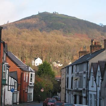
4 2 Historical context and... Llangollen is an historic settlement lying within a narrow section of the Dee Valley, confined by Ruabon Mountain to the north and the Berwyn massif to the south. The remains of Castell Dinas Bran, said to be the burial site of the Holy Grail of Arthurian legend, loom over the town from an isolated hill to the north east. The nearest main towns are Wrexham (11 miles) and Bala (19 miles). Llangollen takes its name from its founding saint, Saint Collen, who was thought to have established a church in the town during the 6th or 7th century, around which the first community began to form. The settlement also afforded a good crossing point and it is believed that Edward I funded the construction of the first river bridge. This was later rebuilt in the form of the current Dee Bridge in 1345 by the Bishop of St. Asaph. More recent alterations included the incorporation of an arch to accommodate the railway, and a widening scheme during the 1960s. For several centuries, Llangollen remained little more than a village, with the main settlement being based around the area to the south-east of the bridge, mainly comprising Bridge St. and Church St., and to the north-east around the old village green (now the site of the station). However, the town subsequently experienced a dramatic expansion due to a number of improvements in transportation, including the arrival of the Llangollen branch of the Shropshire Union Canal, to the north of the river, in The town s growth was also due to its strategic position on the A5 London to Holyhead coach road, which was improved by Thomas Telford in Top left: River bridge circa: 1794 Above: The Church from Bridge St. l(ate eighteenth century) Right: Plan of Llangollen 1873


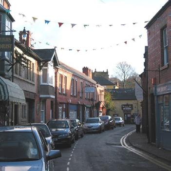
5 modern day Llangollen 3 Nearly fifty years later, the opening of the Ruabon to Barmouth railway resulted in a densely populated area to the north of the river being demolished to accommodate the new station and sidings. Development within this area has remained constrained by the east/west lines of both the canal and railway ever since. These improvements in transport and the availability of local natural resources assisted in the development of various industries within Llangollen, most particularly the mills based around the river. The Victorian era heralded the construction of Castle Street, built between 1850 and 1870 and linking through to Telford s much improved coach road. The street s north/south axial route no longer required traffic to negotiate the historic old town and provided Llangollen with a main shopping boulevard. This new approach to the town s urban planning was expanded to include an area to the west through the construction of a rectangular street grid, a format which was extended in later years. Modern Day Llangollen With a population of around 3,000, Llangollen is perhaps most famous as the home of the annual International Music Eisteddfod which is held every July and brings tens of thousands of visitors to the town. Tourists are also drawn by its spectacular local scenery, with the town providing a base for outdoor activities. Other attractions include the steam railway and canal which provide additional interest focus for transport enthusiasts and tourists alike. Top right: town viewed from bridge Above: Eisteddfod ground Left: Plan of modern day Llangollen red line illustrates boundary of Conservation Area blue line illustrates boundary of NLP study area


6 4 There is a wealth of built heritage both within Llangollen and nearby, much of which is subject to protected status. There are a large number of listed buildings within the centre, the majority of which make a positive contribution to the local character, and all of which have the potential to contribute to the quality of the town s built environment. Many of these buildings provide key landmarks within the town including The Town Hall, St Collens Church and The Royal Hotel. The town centre has also retained its commercial and retail functions, including the local market. Within the wider context, modern Llangollen has expanded someway beyond its Victorian boundaries despite the restrictions imposed by the route of the railway, canal, main roads and topography. Whilst some linear or ribbon development is evident along main roads, the most obvious area of expansion lies to the southeast of the town centre. The layout of the Pengwern estate clearly shows the formal urban planning applied to this site, and other developments within the same area also display the same characteristics. The main areas of development to the west of the town have been the Royal International Pavilion, at the Eisteddfod Ground to the north of the river, and an industrial works to the south. To the east, Pen Y Coed is a sizeable residential development which occupies land accessed off Maesmawr Road. The document Llangollen A Strategy for the 21st Century highlighted a vision: To make Llangollen a prosperous place to live, work and visit, through becoming a unique and renowned tourist attraction. To achieve this vision, the town needs further investment and some small scale development where opportunities arise. Such schemes, whatever the scale, need to be handled sensitively, most particularly within the historic central area of the town. And whilst the town s strategic position on the A5 ensures a steady flow of traffic through Llangollen, there is still room for aesthetic improvement at critical arrival points.


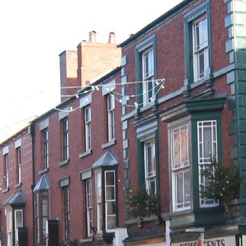
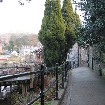
7 Character 5 Welsh national planning guidance highlights the importance of appreciating both the context and the characteristics of an area in which a development is located. The positive features of a place, such as its landscape, building traditions and materials, help to give it a sense of identity. The best places are memorable and possess a character which people can easily appreciate. Consequently, the features which differentiate Llangollen from elsewhere need to be taken into account whenever development of any scale is being considered within the town. Llangollen s key characteristics are: The town s relationship to its setting within the valley, with the views from within and through Llangollen bringing the surrounding hills into the heart of the town. The dramatic focus provided by the river - the views along it to the east and west, which are important for the perception of the town. Dee Bridge as a defining feature of the town and an important historic landmark. Castle Street as key, axial route and visual corridor. The railway as a gateway feature of the town. Extensive riverside access, incorporating promenades open spaces and parks. The contrast between the formality of the grid street layout to the west of Castle Street and resultant clear, linear views, and the looser layout of the earlier streets to east, where the eye follows the view of a curved streetscape. The historic character, charm and interest of buildings within the central area, as defined by the Conservation Area boundary and listed building status. The simplicity of the building forms, consistent in height (generally 2-3 storeys) and enriched through detailing and the variety of materials. The informality of the visual relationship between buildings of differing ages and styles. Terraced frontages featuring a standard building line with occasional set backs. The dense grain of development, a sense of enclosure and intimate human scale.


8 6 Urban Design It is important to note that urban design is not limited to the study of a particular structure or collection of buildings. It is concerned with the overall quality and impact of the built environment. Good design should respect and enhance its context, whilst poor design can have a wider damaging effect. Successful places tend to have some characteristics in common. These were categorised in a CABE document By Design to produce a series of objectives for good urban design: Character: Promoting character in townscape and landscape by responding to and reinforcing locally distinctive patterns of development, landscape and culture. Continuity and enclosure: Promoting continuity of street frontages and the enclosure of space, clearly defining private and public areas. Quality of public realm: Promoting public spaces and routes which are safe, uncluttered and work effectively for all. Ease of movement: Promoting accessibility and local permeability by making places that connect with each other and are easy to move through. Legibility: Promoting legibility by providing recognisable routes, intersections and landmarks to help people find their way around. Adaptability: Promoting adaptability through development that can respond to changing social, technological and economic conditions. Diversity: Promoting diversity and choice through a mix of compatible developments and uses that work together to create viable places that respond to local needs. Llangollen s built form already provides examples of good quality urban design. However, these need to be strengthened through adhering to these objectives, gaining a better understanding of the town s character and working with the local context.


9 Architectural Style 7 It is essential that new development sits well with the character and quality of the town s built environment. It will need to respect the importance of local styles and materials so that informed decisions can be made when making alterations or designing new developments. Architectural styles within the study area include: Simple Georgian facades associated with town s period of expansion, as the predominant style. Earliest buildings situated in Bridge Street and Church Street, the Church of St. Collen being the oldest an example of Early English Gothic subject of many alterations. Civic buildings built during the Victorian period but in the Early Gothic style. Examples of late Victorian and Edwardian architecture articulated in Ruabon brick. Building materials used within the study area include: Locally available timber and shale stone. Limestone construction after the arrival of the canal. Sandstone from railway cuttings. Ruabon brick brought into the town by rail. Slate provides the town s principal roofing material. Painted render, with contrasting detailing remains the most common finish within the town. Design detail is of particular significance to the character of Llangollen, and includes many quality examples of : Projecting bays at first floor level Coloured render with contrasting details Mock Tudor detailing Vertical sash windows Mixture of flush and overlapping eaves/verge details Terracotta ridge tiles (red and blue/black) Iron railings and gates Stone boundary walls Traditional hanging signs


 Other guidance which should be taken into account includes Planning Policy Wales Technical Advice Note 12: Design.")


.")
10 8 Design Guidance Any development proposal which could potentially affect the town centre s listed buildings or conservation area would need to be designed with particular care. Supplementary Planning Guidance Notes provided by Denbighshire County Council which are important in this regard include: SPG 1: Extension to Dwellings SPG 8: Access for All SPG 12: Shopfronts SPG 13: Conservation Areas SPG 14: Listed Buildings SPG 17: Advertisements An inclusive Design approach is recommended to incorporate design and facilities that can be used equally by everyone, irrespective of age, gender or disabilitiy, promoting a barrier free environment and Access for All. (See Disability Discrimination Act, relevant planning legislation and guidance.) Other guidance which should be taken into account includes Planning Policy Wales Technical Advice Note 12: Design. The Welsh Development Agency s Design Guide and the Commission for Architecture & the Built Environment s (CABE) publications By Design and Paving the Way also provide excellent sources of reference. The uniqueness of the character of Llangollen has been developed over centuries and is at risk of being destroyed if unsympathetic development and alteration is allowed. It must be ensured that the elements which define the quality and individuality of the study area are retained and that potentially destructive changes, such as alien design styles and imported materials are resisted. The cumulative effect of a number of progressive changes to seemingly minor details, such as the installation of UPVC doors and windows, concrete roof tiling and the removal or covering of architectural detailing, can be to destroy characteristics which have taken centuries to evolve. Similarly care must be taken to minimise superfluous additions to buildings and general pavement clutter (see Streetscape ). Colour also plays an important role in the streetscene and great care should be taken in its choice. Bright colours should be avoided because of their tendancy to detract from the quality of the historic envionment. Instead more traditional colours and muted tones should be employed for the overall visually harmony of the street. Attention should also be given to minor permitted development proposals, for which planning consent is not necessary but which may have disproportionate effect upon the quality and character of buildings.
11 Townscape 9 The following pages briefly describe the main components of a typical streetscene, and provide guidance on appropriate and inappropriate ways of undertaking both alterations to existing buildings, and the development of a gap site or infill plot within the street. chimneys Key elements of streetscape are affected by: Mass and Form: a building s height, width and construction determines how prominent it is within the street. existing building line addresses & encloses the street ridgeline potential infill development plot Windows: Windows on the front facades of buildings play an important role in the appearance and continuity of new development within its local context. Consideration should be given not only to the size and amount of window coverage on existing adjacent facades, but also the position which a window is set into the building s facade as this provides a sense of depth to the elevation. eaves building facade front facing dormer Scale: a building s scale is not just concerned with its size. If it is made up from a number of smaller elements its scale will seem smaller than if it just consists of one block. The use of features such as dormers can assist in reducing the scale of a building. Conversely a building can be given more emphasis by the features incorporated into its design. Roofscape: it is important to take into account how roofs address the street. In Llangollen the majority of the steeply sloping, slate roofs are generally orientated with the main ridgelines parrallel to the street, and many are punctuated with brick chimney stacks. Materials & Detailing: all too often trying to imitate architectural styles results in a poor copy. It is better to focus on respecting the proportions of existing buildings and ensuring a well defined relationship with the street. The use of local materials helps buildings to fit in with their surroundings. Proportions: the character of an area is influenced by the proportions of buildings which give either a vertical or horizontal emphasis to the street.
 Illustrations of how both poor alterations to existing properties and visual clutter detract from the quality of the streetscene Illustration of")
12 10 Guidance Typical townscape highlighting poor development principles... (to be compared with example on following page) Illustrations of how both poor alterations to existing properties and visual clutter detract from the quality of the streetscene Illustration of infill development which is inappropriate to its immediate context Existing property displaying original features I N F I L L S I T E Satellite dishes dotted across front elevations. Internally illuminated projecting box signs. A frame advertisements obstructing/ cluttering the footpath. Loss of glazing pattern due to thoughtless replacement. Replacement of existing with UPVC windows displaying thick sections & inappropriate division. Lack of depth to elevations due to position within wall. Removal of original chimney resulting in lack of visual interest on skyline. Use of external cladding not typical of the local area. Flat roof dormer replacing traditional dormer. Replacement of existing slates with concrete tiles. Gable fronting street, compared to other properties whose ridgelines run parrallel to street. Window proportions giving horizontal rather than vertical emphasis to facade. Detailing which is uncharacteristic of area: arched brick lintels projecting porch contrasting panels Oversized, unattractive signage to shopfront. Roller shutter box fitted to front of fascia. Expansive glazing with little divison. Prominence of ventilation systems on building facade.
 Illustration of alterations to an existing property which enhance the adjacent streetscene Illustration of infill development which is appropriate to")
13 11 Typical townscape highlighting good development principles... (to be compared with example on previous page) Illustration of alterations to an existing property which enhance the adjacent streetscene Illustration of infill development which is appropriate to its immediate context Existing property displaying original features I N F I L L S I T E Removal of unnecessary clutter from building facade. Relocate satellite dishes/ security boxes etc to less conspicuous position. Inclusion of detailing which is more in keeping with the local vernacular hanging signs,externally illuminated. Removal of A frame advertisement boards. Replacement of glazing with similar. Replacement timber sash windows and painted timber doors. Traditional front facing dormer in keeping with adjacent property. Retain existing chimney for visual skyline interest. External finish in keeping with local vernacular (see architectural style section). New or reclaimed local slate to roof. Eaves to line through with existing. Gabled dormers to third storey. Windows displaying vertical emphasis through use of glazing mullions. Use of detailing that is common to Llangollen including: projecting first floor bay stone quoins and lintels sliding sash windows Signage within appropriately proportioned fascia board. Security grilles fitted internally if possible or housed behind fascia. Glazed area framed by shopfront consisting of pillasters, fascia and stallriser.


.")
14 12 Streetscape The streetscape comprises the elements between the buildings, including; floorscape, street furniture, lighting, planting and signage. Unfortunately incremental additions and adhoc alterations often result in clutter which detracts from the overall quality of an area. Whilst such works are often as a direct response to practical issues, a co-ordinated approach to works by utility companies, building owners and the local authority will result in a more organized and attractive street scene. The strategy to improve Llangollen s streetscape should be based upon the: Reduction of clutter Minimising the number of elements by considering whether each item is necessary, whether it should remain, be removed or be made less obtrusive (through relocating or redecoration). Ventillation ducts, satellite dishes,and unecessary signage all contribute to produce a detrimental effect on an area s visual amenity. The proliferation of moveable advertising boards can prove hazardous as well as being unsightly. Therefore their use and positioning should be carefully considered. The number of posts within the street should be reduced through encouraging shared usage where appropriate. The replacement of existing street furniture should aim to create a consistency of style and placement through a co-ordinated approach. Design and Maintenance The design and maintenance of Llangollen s streetscape should respect areas of existing quality, and enhance those of lesser merit. Poor maintenance practices can hasten the visual deterioration of the public realm. Reinstatement works should be carried out on a like for like basis, ensuring a continuity of surface materials, appropriate to the setting. The use of a limited palette of floorscape materials will encourage visual clarity at ground level. Similarly furniture should be subject to a coherent painting scheme. Service covers should be orientated to sit 90 o to the paving bond. Where this is not possible recessed covers should be used.


15 The Way Forward 13 Initiatives such as the Welsh Assembly Government s Town Improvement Grant and Tourism Growth Area, already exist within Llangollen, providing a positive focus for development within the town. Schemes such as the proposed environmental works for the Mill St/ Abbey Road/ Castle Street junction also illustrate the enthusiasm within the town to improve its environment. In conclusion, the preservation and enhancement of central Llangollen means: Ensuring new buildings are sympathetic to the surrounding streetscape in terms of size, massing, eaves height, roofscape and building lines. Requiring that alterations to existing buildings are carried out with as much consideration as new build works. Protecting the town s unique characteristics through both enhancing as well as conserving its historic fabric. Responding to and reinforcing locally distinctive pat terns of development. Strengthening the visual relationship of properties which front onto the river. Promoting the continuity of street frontages and the enclosure of space. Promoting diversity through a mix of compatible developments and uses that work together to create viable places. Encouraging public spaces and routes which are safe, uncluttered and work effectively for all. In order to maintain the many unique features of Llangollen, it is essential that development be carried out sympathetically and in accordance with the guidelines within this document and the principles laid down by national and local government.


16 Development Control Manager Planning & Public Protection Services Denbighshire County Council Caledfryn Denbigh LL16 3RG Tel: Conservation Architect Development Services Denbighshire County Council Canol y Dre Ruthin Denbighshire LL15 1QA Tel: Llangollen Town Council Parade Street Llangollen Denbighshire LL20 8PW Tel: Produced by Nathaniel Lichfield and Partners Ltd.
Character Area 1: Town Core
 Character Area 1: Town Core Map S 354 Copyright Cotswold District Council 109 Character Area 1: Town Core Key Characteristics 355 356 357 358 359 360 361 362 363 364 365 366 367 368 369 370 Copyright Cotswold
UPPER GORDON ROAD TO CHURCH HILL, CAMBERLEY CONSERVATION AREA
 Introduction This leaflet explains the purpose of conservation areas and the implication of their designation for residents, property owners and the Council. It provides you with a plan of the area and
Lancaster Conservation Area Appraisal. Character Area 8. Cathedral
 Lancaster Conservation Area Appraisal Character Area 8. Cathedral March 2013 118 3.8 Character Area 8. Cathedral 3.8.1. Definition of Special Interest "This character area is distinctive for the fine group
Status of Supplementary Planning Guidance OLD WOKING CONSERVATION AREA Character Appraisal and design Guidance
 Status of Supplementary Planning Guidance OLD WOKING CONSERVATION AREA Character Appraisal and design Guidance Status This Planning Guidance which is supplementary to Policy BE9 of the Woking Borough Local
MATURE SUBURBS RESIDENTIAL DEVELOPMENT GUIDELINES
 MATURE SUBURBS RESIDENTIAL DEVELOPMENT GUIDELINES DRAFT FEBRUARY 2005 BIRMINGHAM CITY COUNCIL 1 Introduction Mature Suburbs Residential Development Guidelines - Interim Supplementary Planning Advice -
Conservation Area Designation, amendments and Review
 Conservation Area Designation, amendments and Review Location: Any area largely confined to Park Road and St. James Avenue which includes the following properties: St. James Church, St. James Road; No.
22.15 OUTDOOR ADVERTISING SIGNAGE POLICY
 22.15 OUTDOOR ADVERTISING SIGNAGE POLICY This policy applies to all land where a planning permit is required to construct or display a sign under the provisions of the Kingston Planning Scheme. 22.15-1
Conservation Area Designation, amendments and Review
 Conservation Area Designation, amendments and Review Location: No.s 37-49 (odd) Twickenham Road Date Assessed: January 2018 Adjacent Conservation Area Significance: Teddington Lock CA. The Teddington Lock
PART AOTEA PRECINCT
 CONTENTS... PAGE AOTEA PRECINCT...4 14.5.1 INTRODUCTION...4 14.5.2 RESOURCE MANAGEMENT ISSUES...4 14.5.3 RESOURCE MANAGEMENT OBJECTIVES AND POLICIES... 4 14.5.4 RESOURCE MANAGEMENT STRATEGY...5 14.5.5
STRENSALL RAILWAY BUILDINGS CONSERVATION AREA APPRAISAL. In association with Strensall with Towthorpe Parish Council
 STRENSALL RAILWAY BUILDINGS CONSERVATION AREA APPRAISAL In association with Strensall with Towthorpe Parish Council CONTENTS Page 1 Introduction 2 2 Location and Context 3 3 Topography and Setting 4 4
2.0 Strategic Context 4
 2.0 Strategic Context 4 2.1 The Area Action Plan is a non-statutory plan, which forms a corporate policy document, expressing particular issues and areas of concern while also providing a vision for the
Colchester Northern Gateway Master Plan Vision Review Draft. July 2016
 Colchester Northern Gateway Master Plan Vision Review Draft July 2016 Contents Introduction 4 Context 8 Purpose of the Report 8 Strategic Position 9 Overview of the Process 11 2012 Master Plan Vision 12
BROADHEMBURY DESIGN STATEMENT
 BROADHEMBURY DESIGN STATEMENT As drawn up by Broadhembury Parish Council during the development of a Parish Plan and adopted at its meeting on 17 th May 2010 BROADHEMBURY DESIGN STATEMENT Contents Introduction
APPENDIX MATAKANA COMMERCIAL URBAN DESIGN GUIDELINES
 APPENDIX MATAKANA COMMERCIAL URBAN DESIGN GUIDELINES 1.0 INTRODUCTION The following urban design guidelines are to be utilised by landowners, planners and other persons involved in development at early
GREAT WESTERN SQUARE & ENVIRONS
 GREAT WESTERN SQUARE & ENVIRONS Draft Architectural Conservation Area Report Character Appraisal and Policy Framework 20 1 Architectural Conservation Area Report: GREAT WESTERN SQUARE & ENVIRONS Draft
Streets for All East of England
 Streets for All East of England Summary In 2017 Historic England published an updated national edition of Streets for All, a practical guide for anyone involved in planning and implementing highways and
7.1 Area 1: Haslemere Conservation Area
 7.1 Area 1: Haslemere Conservation Area Detailed map of Haslemere Town Conservation Area as of 2006 Crown copyright and database right 2011 Ordnance Survey LA100025451 27 The Conservation Area is characterised
General principles for telecommunications development. Mast and site sharing. Installation on existing buildings and structures
 General principles for telecommunications development Mast and site sharing Installation on existing buildings and structures Camouflaging and disguising equipment Using small scale equipment Erecting
Design Guidance. Introduction, Approach and Design Principles. Mauritius. November Ministry of Housing and Lands. .. a
 sig evelo r D Mauritius s. Utilities.. Individu a s. er itects.to ls chpers.po e Public. T. h rban D Sc U e me Promot e h ners. A Design Guidance o.h Planne rs n w iticians r l useholde National Development
PLANNING STATEMENT. Market House Market Place Kingston upon Thames KT1 1JS
 PLANNING STATEMENT To support planning and listed building consent applications for change of use from Class A1 shop and Class A3 cafe to Class A3 restaurant at: Market House Market Place Kingston upon
Chapter 5 Urban Design and Public Realm
 5.1 Introduction Public realm is all areas of the urban fabric to which the public have access. It is where physical interaction takes place between people. It therefore, includes buildings and their design,
URBAN DESIGN BRIEF REPORT
 URBAN DESIGN BRIEF REPORT PREPARED FOR 2568401 ONTARIO INC NEW GASBAR, CONVENIENCE STORE & CARWASH DEVELOPMENT @ 1509 FANSHAWE PARK ROAD WEST LONDON, ONTARIO GAMA ENGINEERING INC. PROJECT NUMBER 1669 PREPARED
DESIGN GUIDANCE NOTE NO: 5 EXTENSIONS TO HOUSES
 DESIGN GUIDANCE NOTE NO: 5 EXTENSIONS TO HOUSES This note is one of a series providing design guidance for development in the borough. It explains the criteria used by the council to decide planning applications
Character Area 9. Residential: South West
 Lancaster Conservation Area Appraisal Character Area 9. Residential: South West March 2013 128 3.9 Character Area 9. Residential: South West 3.9.1. Definition of Special Interest "This character area is
Character Appraisal Zone 1: Charlotteville. i Topography, Views and Vistas
 Conservation Area Study and 3 Zone 1: Charlotteville For boundaries, please refer to Map 2 in the Appendices at the rear of this document. Charlotteville has a strong identity distinct from other parts
Planning scheme policy for Landsborough (urban design guidelines)
") SC6.2 SC6.2.1 Planning scheme policy for Landsborough (urban design guidelines) Purpose The purpose of this planning scheme policy is to provide advice about achieving outcomes in the Landsborough local
SC6.2 SC6.2.1 Planning scheme policy for Landsborough (urban design guidelines) Purpose The purpose of this planning scheme policy is to provide advice about achieving outcomes in the Landsborough local
5 Gratton Terrace London NW2 6QE. Reference: 17/5094/HSE Received: 4th August 2017 Accepted: 7th August 2017 Ward: Childs Hill Expiry 2nd October 2017
 Location 5 Gratton Terrace London NW2 6QE Reference: 17/5094/HSE Received: 4th August 2017 Accepted: 7th August 2017 Ward: Childs Hill Expiry 2nd October 2017 Applicant: WSD (Gratton) Ltd Proposal: The
PUBLIC REALM STUDY AREA
 WELCOME PUBLIC REALM STUDY AREA WHAT IS PUBLIC REALM? Welcome to the Ballina Town Public Realm public consultation event. Mayo Council is in the process of producing a Public Realm Strategy for Ballina
Industrial Workers Housing in Wales
 Industrial Workers Housing in Wales Judith Alfrey, Cadw Alfred Terrace, Taffs Well, R.C.T. Cwmparc, Rhondda Windmill Court, Aberystwyth William Street, Aberystwyth Alfred Terrace, Taffs Well, Rhondda Cynon
1. Listed Building and Conservation Area considerations 2. Protection of Known Archaeological Remains 3. Parking
 08/01222/FUL ERECTION OF SINGLE STOREY SIDE EXTENSION TO CHURCH TO PROVIDE FOR PARISH HALL (RESUBMISSION OF 08/00206/FUL) AT St Mary And St Giles Church, Church Street, Stony Stratford FOR Rev R Northing
17. Coolaney-Rockfield Mini-Plan
 County Development Plan 2017-2023 Consolidated Draft + Adopted Amendments - August 2017 17. Coolaney-Rockfield Mini-Plan Village profile Coolaney is located approximately 23 km to the south-west of Sligo
KEY MAP DEVELOPMENT PERMIT AREA MAP. Sunnymede North Sub-Area Plan
 Richmond Official Community Plan BROADMOOR AREA SUNNYMEDE NORTH SUB-AREA PLAN Bylaw 7100 Schedule 2.6C SUNNYMEDE NORTH SUB-AREA PLAN SUNNYMEDE NORTH SUB-AREA PLAN SUNNYMEDE NORTH SUB-AREA PLAN KEY MAP
6. Design and Architectural Guidance
 6. Design and Architectural Guidance The following Design Guidelines are proposed to apply to all areas of Haslemere. They are intended to enhance and maintain the character and scale of the area. Principles
PLANNING COMMITTEE. 14 October 2014
 AGENDA ITEM NO 8 PLANNING COMMITTEE 14 October 2014 APPLICATION NUMBER : CA//14/01744/FUL PROPOSAL : Extension and conversion of roof space of an existing detached bungalow together with enhanced parking
6 Site Framework Strategies
 6 Site Framework Strategies 6.1 Introduction Section 6 identifies a number of specific areas which are considered to be key sites within the Plan area and which may have potential for development / redevelopment.
WELLINGTON HOSPITAL DESIGN GUIDE TABLE OF CONTENTS
 WELLINGTON HOSPITAL DESIGN GUIDE TABLE OF CONTENTS 1.0 Introduction Page 2 The Place of Wellington Hospital 2 The Future of the Hospital 2 2.0 The Intention of the Design Guide 3 3.0 Analysis 4 General
Design statement. for redevelopment of. former industrial use site at Willenhall, to. residential use.
 Design statement for redevelopment of former industrial use site at, to residential use. Good design can help create lively places with distinctive character; streets and public spaces that are safe, accessible,
STATEMENT OF OBJECTION TO THE PROPOSED DEVELOPMENT OF LAND AT CHURCH CLIFF DRIVE FILEY
 STATEMENT OF OBJECTION TO THE PROPOSED DEVELOPMENT OF LAND AT CHURCH CLIFF DRIVE FILEY You will be aware that Scarborough borough council have adopted a new local plan that includes land at Church Cliff
Appendix D North Road/N. Leroy Street Subarea Plan
 North Road/N. Leroy Street Subarea Plan INTRODUCTION The City of Fenton Master Plan was updated in 1996 and included a subarea plan for the North Leroy Street area of the City. It was recognized at that
4. MASTERPLAN FRAMEWORK
 6a 6b 4. MASTERPLAN FRAMEWORK 6. Car Parks 6c Car Parks 6a and 6b will provide permanent parking. Area 6a will serve the foodstore with tarmac surfacing within a defined area to the west of the adjacent
New-Cast Mixed-use Development Proposal King Street West, Newcastle, Ontario
 URBAN DESIGN BRIEF New-Cast Mixed-use Development Proposal King Street West, Newcastle, Ontario TABLE OF CONTENTS: 1.0 Executive Summary 2.0 Creating Vibrant and Sustainable Urban Places: Excerpts from
Appraisal of proposed alterations to the boundary of Helmsley Conservation Area
 Appraisal of proposed alterations to the boundary of Helmsley Conservation Area Elmslac Road: Elmslac Road was constructed in the early 1950s in two or three stages by the Helmsley Rural District Council.
Response to the London Bridge Area Vision and Site Allocations within the New Southwark Plan
 1 Melior Place London SE1 3SZ 020 7407 4701 teamlondonbridge.co.uk info@teamlondonbridge.co.uk 28 April 2017 Response to the London Bridge Area Vision and Site Allocations within the New Southwark Plan
List of Buildings of Local Architectural or Historic Interest BUCKHURST HILL PARISH
 List of Buildings of Local Architectural or Historic Interest BUCKHURST HILL PARISH 1. ST. STEPHEN'S CHURCH Albert Road /Buckhurst Way Attractive, albeit modest, late 19th century church (date stone 1876)
LONGDEN VILLAGE DEVELOPMENT STATEMENT
 LONGDEN VILLAGE DEVELOPMENT STATEMENT 2017-2027 1 Longden Development Statement 2017-2027 15/01/18 1. Background 1.1 Longden Village Longden village is a very rural and traditional community first mentioned
The Master Plan also identified a number of issues and these issues remain and if anything have become more acute since 1997.
 Ringsend AAP Introduction Dublin Docklands Area Master Plan (the Master Plan) identified a number, of areas within Docklands where more detailed planning would be appopriate. One of those areas is the
DESIGN & ACCESS STATEMENT. REVISION A Residential Development, Neon Social Club, Nairn Street, Jarrow.
 DESIGN & ACCESS STATEMENT. REVISION A Residential Development, Neon Social Club, Nairn Street, Jarrow. The following Design & Access Statement is in support of a Full Planning Application for a residential
WINDSOR GLEN DESIGN GUIDELINES
 WINDSOR GLEN DESIGN GUIDELINES Adopted by Council, 2006 WINDSOR GLEN REDEVELOPMENT DESIGN GUIDELINES August 2006 1.0 Master Plan Organization For this area of the Coquitlam Town Centre, a mix of high,
DESIGN & ACCESS STATEMENT
 . DESIGN & ACCESS STATEMENT Site Adjacent to The Manor House, Upper Street,, Kingsdown, Deal, Kent. DESIGNS ARCHITECTURE + PLANNING CONTENTS Design and Access Statement Introduction Site and Location Planning
4.0 Design Guidelines For The Village Centre. South fields Community Architectural Design Guidelines Town of Caledon
 4.0 Design Guidelines For The Village Centre 4.0 Design Guidelines for the Village Centre The Village Centre is the focal point of the entire South Fields Community and is designed as a traditional commercial
Workshop 3. City of Burlington Waterfront Hotel Planning Study. September 14, The Planning Partnership
 Workshop 3 City of Burlington Waterfront Hotel Planning Study September 14, 2017 The Planning Partnership The Waterfront Hotel Planning Study 01 The Brant & Lakeshore Planning Study will establish a Strategic
Project Design and Access Statement: Rev B - Proposed replacement of the Clubhouse and Golf Shop at Hawkstone Park.
 Project 17-451 Design and Access Statement: Rev B - Proposed replacement of the Clubhouse and Golf Shop at Hawkstone Park. Prepared By: Gary Johns Architects 1.0 Contents: 2.0 Introduction 3.0 Proposed
Section 6.0: Glencullen Design Guide
 Section 6.0: Glencullen Design Guide The Planning Authority requires that the adherence to each of the above principles will be demonstrated at the Planning Application stage using appropriate visualisation
GREENFORD HALL & ADJOINING LAND
 GREENFORD HALL & ADJOINING LAND CONTENTS 1. Introduction 1. Introduction 2. Urban Context 2.1 The Site and Surroundings 2.2 Urban Context Map 2.3 Access and Movement 3. Planning Context 3.1 Planning History
HERITAGE STATEMENT AND IMPACT ASSESSMENT HILLBARK FARMHOUSE FRANKBY
 HILLBARK FARMHOUSE HERITAGE STATEMENT AND IMPACT ASSESSMENT HILLBARK FARMHOUSE FRONT ENTRANCE CONTENTS Executive summary 1.0 INTRODUCTION 1.1. Background to the report 1.2. Purpose of the Report 2.0 SIGNIFICANCE
Hockessin Community Redevelopment Plan
 Hockessin Community Redevelopment Plan 3.1 Introduction The Community Redevelopment Plan for the Village of Hockessin is the result of the people s vision for a distinct village center that serves as the
Purpose of the Variation: The purpose of an ACA is to protect and enhance the special character of the ACA by:
 To the Lord Mayor and Report No. 202/2017 Members of Dublin City Council Report of the Assistant Chief Executive Proposed Draft Variation (No. 2) of Dublin City Development Plan 2016 2022 Designating Hollybrook
DRAFT City Road Cardiff CF24 3BJ DESIGN & ACCESS STATEMENT
 11-13 City Road Cardiff CF24 3BJ DESIGN & ACCESS STATEMENT DRAFT PROPOSAL: Full planning application for the creation of a new eleven storey building comprising purpose built student accommodation for
4.0 URBAN DESIGN FRAMEWORK. The vision for the future development of the plan area is to:
 4.0 The vision for the future development of the plan area is to: Create a new neighbourhood that focuses on the highly valued natural and aesthetic features of the lands and provides good quality homes,
97 Lea Bridge Road, Leyton, E10 7QL London Borough of Waltham Forest December 2015
 97 Lea Bridge Road, Leyton, E10 7QL London Borough of Waltham Forest December 2015 Public Realm and Landscape Proposals LEA BRIDGE ROAD, WALTHAMSTOW Public Realm & Landscape Proposals BDP(90)RPT001 December
Hendersonville Historic Preservation Commission Main Street Local Historic District Design Guidelines
 Hendersonville Historic Preservation Commission Main Street Local Historic District Design Guidelines Adopted May 16, 2007 Revised September 15, 2010 Drafted by the members of the Proposed Main Street
URBAN DESIGN BRIEF. 2136&2148 Trafalgar Road. Town of Oakville
 URBAN DESIGN BRIEF 2136&2148 Trafalgar Road Town of Oakville Prepared By: METROPOLITAN CONSULTING INC For 2500674 Ontario Inc November 2016 TABLE OF CONTENTS Page No. 1.0 Introduction/Description of Subject
East Bayshore Road Neighbourhood
 East Bayshore Road Neighbourhood Northridge Property Management Urban Design Brief 3195 East Bayshore Road City of Owen Sound January 2016 East Bayshore Road Neighbourhood Northridge Property Management
Page 1 of 19 URBAN DESIGN FRAMEWORK FOR BOLTON STREET WATERFORD
 Page 1 of 19 URBAN DESIGN FRAMEWORK FOR BOLTON STREET WATERFORD 1.0 Introduction: The relocation of the City Council stores and depot from Bolton Street creates an exciting opportunity for development
The Proposed Auckland Unitary Plan (notified 30 September 2013)
") 3 Business zones Introduction There are 10 business zones in the Unitary Plan: City Centre Metropolitan Centre Town Centre Local Centre Neighbourhood Centre Mixed Use General Business Business Park Light
3 Business zones Introduction There are 10 business zones in the Unitary Plan: City Centre Metropolitan Centre Town Centre Local Centre Neighbourhood Centre Mixed Use General Business Business Park Light
Part 11 Heritage Area Plans West Wallsend / Holmesville
 TABLE OF CONTENTS: PART 1 WEST WALLSEND / HOLMESVILLE HERITAGE AREA PLAN... 3 1.1 INTRODUCTION... 3 1.2 BACKGROUND... 3 1.3 LAND TO WHICH THIS PLAN APPLIES... 3 PART 2 WEST WALLSEND / HOLMESVILLE HERITAGE
DESIGN & ACCESS STATEMENT
 DESIGN & ACCESS STATEMENT January 2016 Contents Introduction section 1 Section 1 - Introduction Section 2 - Assessment Section 3 - Involvement Section 4 - Evaluation Section 5 - Design Section 6 - Layout
Wide asphalt driveway abutting school property. garage built with incompatible materials, too close to park. incompatible fencing materials
 Wide asphalt driveway abutting school property incompatible fencing materials garage built with incompatible materials, too close to park Lack of plantings as a buffer between private property and open
Proposals for the regeneration of Standard Quay, Faversham, Kent
 Proposals for the regeneration of Standard Quay, Faversham, Kent The purpose of this information is to explain the progress in regenerating Standard Quay and to outline proposals with indicative timescales
30. Riverstown Mini-Plan
 County Development Plan 2017-2023 Consolidated Draft + Adopted Amendments August 2017 Volume 2, Chapter 30 Riverstown Mini-Plan 30. Riverstown Mini-Plan Village profile Riverstown is located approximately
Friends Meeting House, Broughton. Meeting House Lane, Little Broughton, Cockermouth, CA13 0YQ. National Grid Reference: NY
 Friends Meeting House, Broughton Meeting House Lane, Little Broughton, Cockermouth, CA13 0YQ National Grid Reference: NY 07832 31740 Statement of Significance The modest building has medium significance
DESIGN PRINCIPLES. Industrial Premises. New Buildings, External Alternations & Signage in Letchworth Garden City.
 DESIGN PRINCIPLES Industrial Premises New Buildings, External Alternations & Signage in Letchworth Garden City. Introduction The world s first Garden City LETCHWORTH IS SPECIAL... It is the world s first
Horwood Map of London, Westminster & Southwark First edition
 Barratt London is developing plans in tandem with Southwark Council and TfL to transform the southern end of Blackfriars Road. The residential-led, mixed-use scheme will deliver new private and affordable
Morgan s Subdivision Historic District Character-defining Features
 Morgan s Subdivision Historic District Character-defining Features DISTRICT DESCRIPTION This small addition, designed as a neighborhood for those wishing to move east from Capitol Hill, was predominantly
COURTHOUSE CAMPUS BARNSLEY Executive Summary March 2010
 COURTHOUSE CAMPUS BARNSLEY Executive Summary March 2010 Estell Warren Cartwright Pickard Buro Happold King Sturge BWA Barnsley Metropolitan Borough Council introduction Courthouse Campus is the last major
Tall Buildings Strategy
 Chapter 8 Tall Building Strategy Mayor of London 115 existing & consented tall buildings effect on views of palace of westminster Chapter 8 Tall Buildings Strategy tall building cluster upto 150m with
Site 2 Development Brief
 a South Marketgait Site 2 b Union Street c Site 2 Development Brief Thomson Avenue (Northern Boulevard) Dundee Riverside Drive Discovery Plaza South Union Street Station Earl Grey Place West Site 5 Site
4.3 Dudley Area Plan. Introduction. History and Existing Character. Desired Future Character for Dudley
 4.3 Dudley Area Plan Introduction The suburb of Dudley has developed as a result of various circumstances including its topography, history and mineral resources. Dudley development has been identified
4 RESIDENTIAL ZONE. 4.1 Background
 4 RESIDENTIAL ZONE 4.1 Background The residential areas within the City are characterised by mainly lowrise dwellings sited on individual allotments. Past architectural styles, settlement patterns and
Appendix DG2 - Central Cambridge Character Guidelines
 DG2.1 DG2.1.1 DG2.1.2 DG2.1.3 Introduction Historic urban areas offer ambience with a special capacity to enrich the lives of users and residents. A conservation approach is required to ensure the survival,
HERITAGE COUNTS 2017 East of England
 HERITAGE COUNTS 2017 East of England Introduction Heritage Counts 2017 is the sixteenth annual survey of the state of England s historic environment. This Regional Report is prepared by Historic England
Chapter 2, Section C: Urban Design and Visual Resources A. INTRODUCTION
 Chapter 2, Section C: Urban Design and Visual Resources A. INTRODUCTION This attachment considers the potential of the proposed East River Waterfront Access Project at Peck Slip to effect urban design
EHTF & Streetscape. Context. Streetscape: a definition. What function? More context. Ian Poole
 EHTF & Streetscape Ian Poole St Edmundsbury Borough Council & English Historic Towns Forum Streetscape: a definition Streets, squares, parks, courtyards, alleys and malls The spaces between buildings Public
Environmental and Landscape Mapping
 Environmental and Landscape Mapping In support of the Calveley Neighbourhood Plan November 2016 Project Name and Number: Calveley Neighbourhood Plan 16-025 Document Name and Revision: Environmental and
Urban Design Guidelines
 Urban Design Guidelines These Urban Design Guidelines comprise the Key Design Objectives below, the Roads Design Guidelines overleaf and Neighbourhood Framework Plans. Together with Section 3: Urban Design
WEST BLACKHALL STREET PUBLIC REALM + TOWN CENTRE CONNECTIONS Public Exhibition 28 th June 2018
 WEST BLACKHALL STREET PUBLIC REALM + TOWN CENTRE CONNECTIONS Public Exhibition 28 th June 2018 Welcome Introduction Design Your Involvement Thank you for coming Engagement We would like to gather to this
ST. LUKE'S. planning consent will not be given for residential uses of ground floor and basement premises currently in non-residential use;
 CA SIXTEEN ST. LUKE'S 16.1 The Council will operate special policies in the St. Luke s Conservation Area in order to preserve and enhance the special character and appearance of the area. 16.2 Lying in
PLANNING COMMITTEE DATE: 07/09/2015 REPORT OF THE SENIOR MANAGER PLANNING AND ENVIRONMENT SERVICE CAERNARFON. Number: 4
 Number: 4 Application Number: C15/0034/37/LL Date Registered: 21/05/2015 Application Type: Full - Planning Community: Llanaelhaearn Ward: Llanaelhaearn Proposal: Location: Summary of the Recommendation:
PLANNING STATEMENT. On behalf of Hindle Property Investments Ltd. Site of the Former Hippodrome Henblas Street, Wrexham LL13 8AD
 PLANNING STATEMENT On behalf of Hindle Property Investments Ltd Site of the Former Hippodrome Henblas Street, Wrexham LL13 8AD Construction of 2 retail units and 13 no apartments August 2018 Martin Planning
DRAFT CONSERVATION AREA APPRAISAL CHAILEY GREEN DESIGNATED
 DRAFT CONSERVATION AREA APPRAISAL CHAILEY GREEN DESIGNATED 16.06.76 DRAFT CHAILEY GREEN CONSERVATION AREA APPRAISAL 1 SUMMARY 1.1 Key Positive Characteristics 1.2 Recommendations 2 INTRODUCTION 2.1 The
B L A C K D I A M O N D D E S I G N G U I D E L I N E S for Multi-family Development
 B L A C K D I A M O N D D E S I G N G U I D E L I N E S for Multi-family Development Adopted June 18, 2009 This section of the Design and focuses on site planning and design guidance for new multi-family
WOKING DESIGN SUPPLEMENTARY PLANNING DOCUMENT (SPD)
") Agenda Item No. 5 EECUTIVE - 15 JANUARY 2015 Executive Summary WOKING DESIGN SUPPLEMENTARY PLANNING DOCUMENT (SPD) The report outlines the various responses to the consultation on the Design Supplementary
Agenda Item No. 5 EECUTIVE - 15 JANUARY 2015 Executive Summary WOKING DESIGN SUPPLEMENTARY PLANNING DOCUMENT (SPD) The report outlines the various responses to the consultation on the Design Supplementary
BENSON / HUNT TERTIARY PLAN
 BENSON / HUNT TERTIARY PLAN TABLE OF CONTENTS 1.0 INTRODUCTION 1.1 Purpose 2 1.2 How to Read This Plan 3 1.3 Tertiary Plan Context 3 1.4 Vision and Principles 5 1.5 Public Consultation 5 2.0 PLANNING CONTEXT
Huddersfield Urban Design Framework. 3. Framework
 3. Framework The illustrative plan has been used as the basis for developing an urban design framework and strategy in Part 3 of this report. This is based on a series of regulatory plans that code the
Duplex Design Guidelines
 Duplex Design Guidelines Adopted by Council May 29, 2006 Prepared By: Table of Contents 1.0 Application and Intent 1 2.0 Areas of Application 2 3.0 Design Principles 3 4.0 Design Guidelines 4 4.1 Site
Appendix A COMMUNITY IMPROVEMENT PLAN DESIGN GUIDELINES
 Appendix A COMMUNITY IMPROVEMENT PLAN DESIGN GUIDELINES INTRODUCTION The continuous and desirable improvement of Arnprior requires a clear understanding of what is envisioned for the Town. These Design
SETTLEMENT ASSESSMENT PROFORMA
 SETTLEMENT ASSESSMENT PROFORMA Surveyors(s):Clare Sheridan Character Area: Park Estate = Midland Rd, Severn Rd, Festival Rd, Park Rd, Willow Rd, Rylands Rd. Date: Feb Weather: cloudy Look through all the
Evidential value The meeting house site is likely to have low archaeological potential and the building has low evidential value.
 Friends Meeting House, Colwyn Bay 21 Erskine Road, Colwyn Bay, LL29 8EU National Grid Reference: SH 85406 78739 Statement of Significance The 1899 meeting house is an attractive late Victorian building
URBAN DESIGN BRIEF NORTHVIEW FUNERAL HOME HIGHBURY AVE N, LONDON, ON
 URBAN DESIGN BRIEF NORTHVIEW FUNERAL HOME - 1490 HIGHBURY AVE N, LONDON, ON 1.1Purpose The intent of the following report is to identify an opportunity for redevelopment of two residential properties within
Linden Homes Proposals for Havant Retail Park, Portsdown Hill Road, Bedhampton. Welcome
 Welcome Welcome to Linden Homes public exhibition in connection with its proposals for a range of high quality new open market, affordable homes and open space on the site of the Havant Retail Park. Today