FINAL MITIGATION PLAN to address
|
|
|
- Erica Tyler
- 5 years ago
- Views:
Transcription
1 CENTRAL CORRIDOR LRT STATE CAPITOL MALL HISTORIC FINAL MITIGATION PLAN February 2010 FINAL MITIGATION PLAN to address Adverse Effects of the Central Corridor LRT Project on the State Capitol Mall Historic District February 25, 2010
2 CENTRAL CORRIDOR LRT STATE CAPITOL MALL HISTORIC DISTRICT FINAL MITIGATION PLAN February 2010 INTRODUCTION This Mitigation Plan has been developed pursuant to stipulations in the Central Corridor Light Rail Transit (LRT) project Programmatic Agreement, executed by the Federal Transit Administration (FTA), the Advisory Council on Historic Preservation (ACHP), the Minnesota State Historic Preservation Office (MnSHPO) and the Metropolitan Council (Council) in June The Central Corridor LRT project is an approximately 11-mile LRT line that will serve the Minneapolis and St. Paul downtown areas, as well as the University of Minnesota (U of M) and the State Capitol complex. In downtown Minneapolis, it will integrate with the Hiawatha LRT line. There will be 20 stations along the line, including five shared with the existing Hiawatha LRT. Below-grade infrastructure to allow for later construction of three future infill stations will be provided and an operations and maintenance facility will be constructed as part of the project. The Central Corridor LRT project will be constructed by the Metropolitan Council. The Federal Transit Administration (FTA) is the lead federal agency in this undertaking. This Mitigation Plan has been developed to address adverse effects findings made by the Minnesota State Historic Preservation Office (MnSHPO) regarding the Central Corridor LRT project s effects on the State Capitol Mall Historic District. ADVERSE EFFECTS NOTED Specifically, MnSHPO found, in a letter dated May 14, 2009 and addressed to the Federal Transit Administration, that: Two lawn panels, contributing elements of the historic district, will be removed for the project. In addition, we believe that the placement of the Rice Street Station along the edge of Leif Erickson Park, a contributing element of the historic district, introduces a structural mass that is out of character with the open nature of this landscape. To be sure, we are working with project designers and the Capitol Area Architectural Planning Board in an effort to reduce that effect through an appropriate station design. However, because the effect is based on placement of the mass of the station immediately adjacent to and over a portion of the open landscape space, the adverse effect can only be reduced, not eliminated. Mitigation for this effect will need to be developed pursuant to Stipulation IV of the [Programmatic] agreement. PROPERTY SETTING AND ASSOCIATION As summarized in Supplemental Historic Properties Investigations and Evaluations for the Central Corridor Light Rail Transit Project, the State Capitol Mall was first evaluated in 1995 as part of the Central Corridor project. At that time, it was recommended for National Register listing under Criterion A for its significance in community planning and development. The State Capitol Mall was characterized as originating from a plan by Cass Gilbert, modified by Clarence Johnston, Jr. and Arthur Nichols (see photos in Attachment A). In the supplemental investigations completed as part of the early stages Page 2 of 6
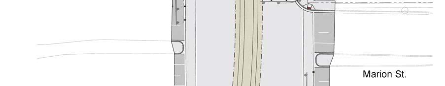
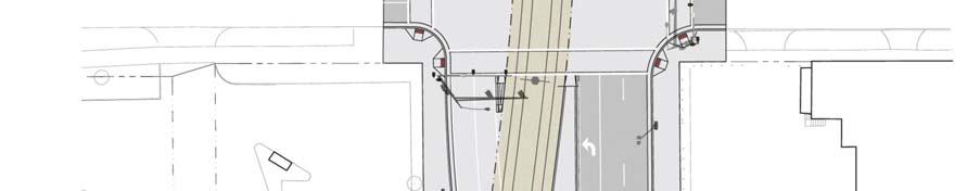
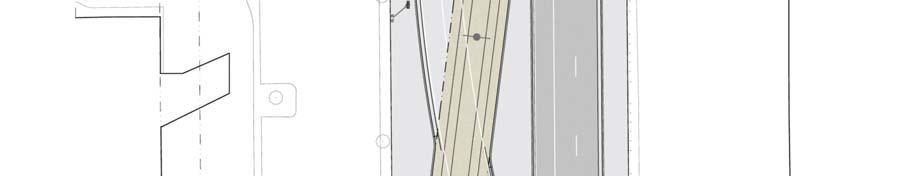
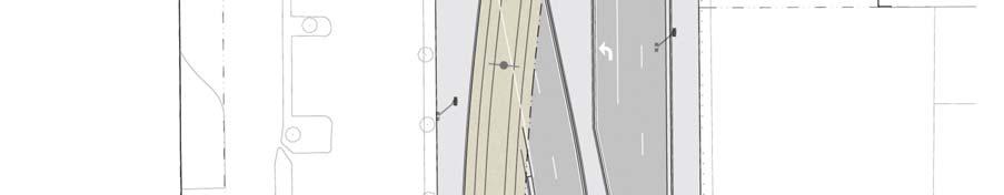
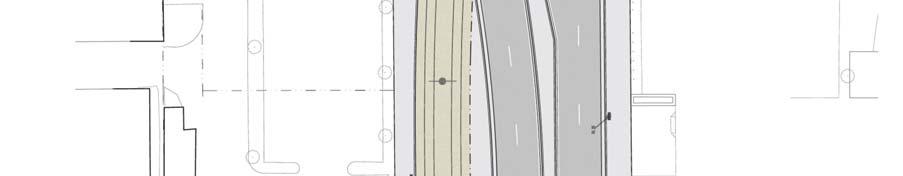
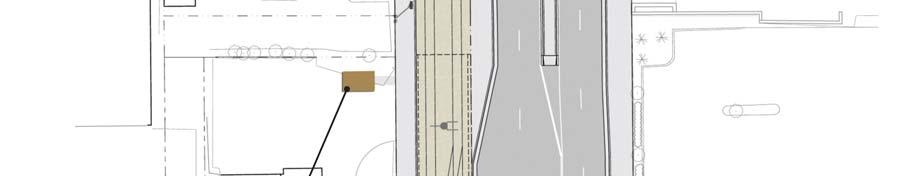
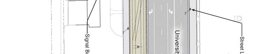
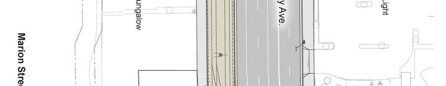
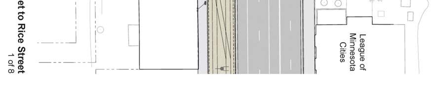
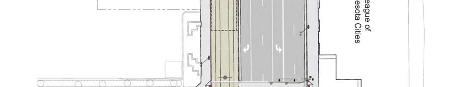
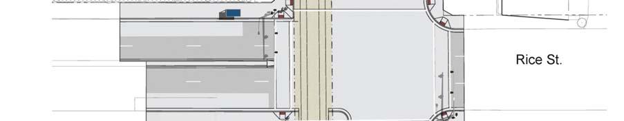
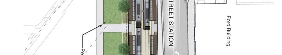
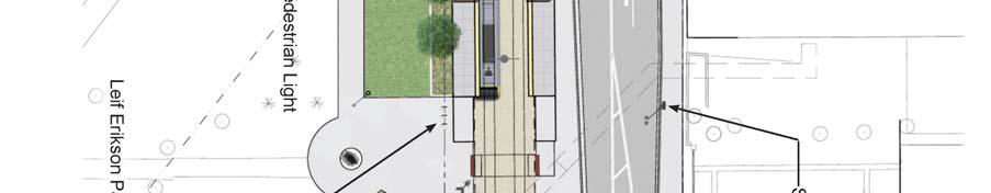
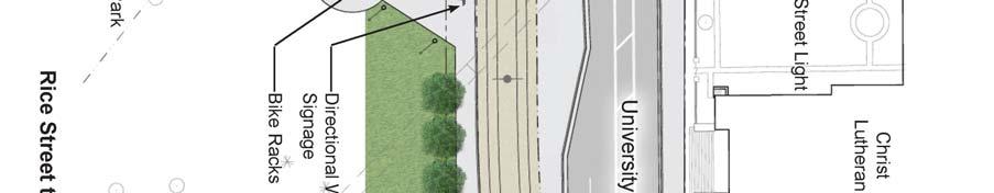
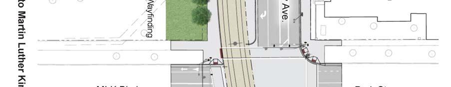
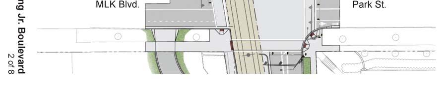
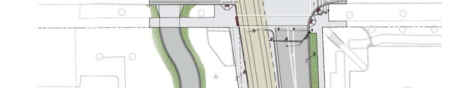
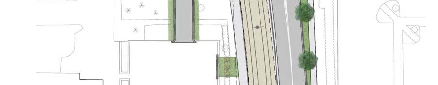
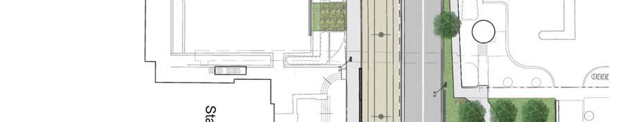
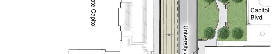
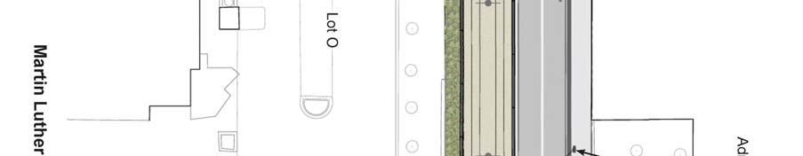
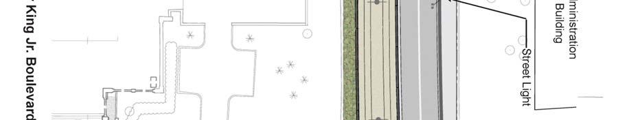
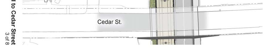
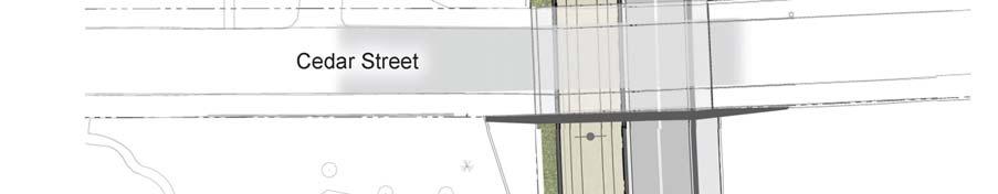
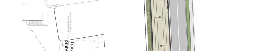
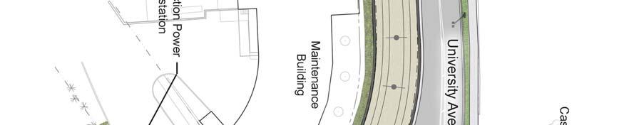
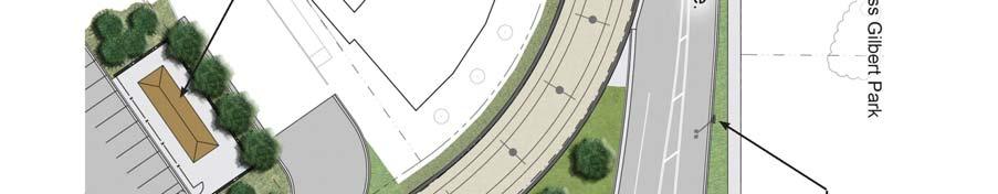
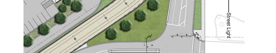
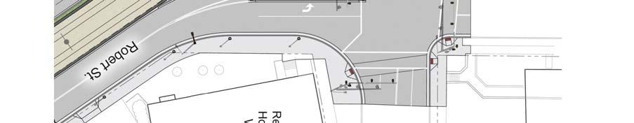
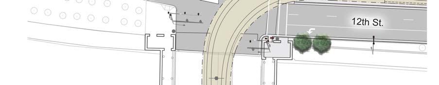
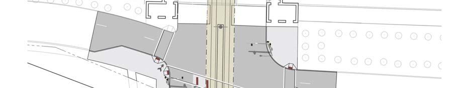
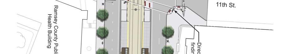
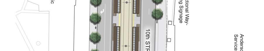
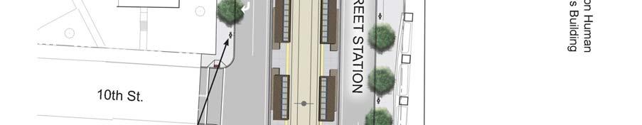
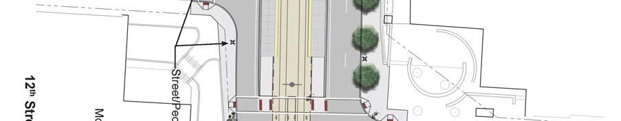
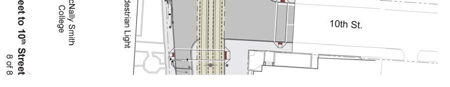
3 CENTRAL CORRIDOR LRT STATE CAPITOL MALL HISTORIC DISTRICT FINAL MITIGATION PLAN February 2010 of Central Corridor LRT preliminary engineering, and as published in the abovereferenced document, it was concluded that it would also be appropriate to recommend listing of the State Capitol Mall under Criterion C in the area of landscape architecture. Such a listing would include the area generally associated with the Mall, as well as the formal approaches, with their grassy medians and flanking boulevards. This recommendation recognizes that vision of Cass Gilbert in designing the State Capitol, of providing a setting inspired by the City Beautiful movement with plazas and axial and radial avenues that would culminate at the Capitol building. A separate investigation of Leif Erikson Lawn in the State Capitol Mall Historic District was also completed in early states of Central Corridor LRT preliminary engineering. As summarized in Supplemental Historic Properties Investigations and Evaluations for the Central Corridor Light Rail Transit Project, Leif Erikson Lawn sits on the state capitol grounds at the corner of University Avenue and Park Street North/Reverend Dr. Martin Luther King, Jr. Boulevard immediately west of the State Capitol building. From about 1890 to 1950, at least four streetcar lines (and probably earlier horsecars) traveled a diagonal route along Wabasha Street, which extended in front of the capitol and bordered the park site on the south. At the turn of the century, several buildings occupied the parcels north of Wabasha Street. These buildings were razed in the mid- 1920s and this portion of the site was designated as part of the State Capitol grounds at that time. The angled section of Wabasha bordering the site was removed around 1940, when the capitol approach was redeveloped and the area s streets realigned. The Leif Erikson monument was installed in Photographs taken during the dedication ceremony show only deciduous trees on the site. Currently, several mature conifers which appear to be Norway Pine and Norway spruce frame the monument on three sides and are clustered closely together on the north. These trees partially, or completely (depending on the angle) obscure the monument from view (see photos in Attachment A). DESCRIPTION OF CENTRAL CORRIDOR LRT AS IT AFFECTS PROPERTY SETTING AND ASSOCIATION The Central Corridor LRT alignment will pass along various boundaries of the State Capitol Mall Historic District within publicly-owned rights-of-way. To the north, it will be constructed on University Avenue. A portion of Leif Erikson lawn adjacent to University Avenue will be occupied by the eastbound Rice Street LRT station platform and by the LRT tracks. The Central Corridor LRT will depart University Avenue, traveling south along Robert Street. The LRT continues south on Robert Street (outside the district boundary) from the eastern terminus of Reverend Dr. Martin Luther King, Jr. Boulevard to 12 th Street. At 12 th Street, the Central Corridor LRT continues west, again along the district boundary. The Central Corridor LRT will head south on Cedar Street, operating in the center of Cedar Street (within the historic district from 12 th Street to 10 th Street) necessitating removal of the landscaped medians to install LRT tracks and the 10 th Street LRT station. The design of the Rice Street station, pedestrian approaches to the station, landscaping, and the relationship of landscape elements to the statue of Leif Erikson and to the State Capitol was the focus of consultation discussions with MnSHPO and other parties, Page 3 of 6
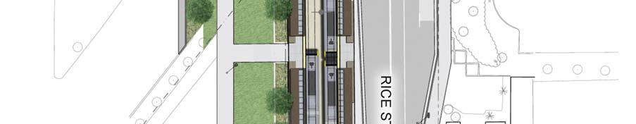
4 CENTRAL CORRIDOR LRT STATE CAPITOL MALL HISTORIC DISTRICT FINAL MITIGATION PLAN February 2010 including the Capitol Area Architectural and Planning Board (CAAPB). Another key area for focus of design consultation discussions was the placement of LRT catenary poles, pedestrian paths, safety fencing and other project infrastructure. Project design plans have been developed in response to issues raised at various consultation meetings, specifically: Softening the effects of the southern edge of the Rice Street station platform as it affects the landscape of Leif Erikson lawn. This was accomplished by creating three symmetrical lawn panels just south of the eastbound station platform, planting Honey Locust trees within the panels, and moving the sidewalk to follow the edge of the lawn panels; Creating other pedestrian amenities (as illustrated in the figure that follows) that restore pedestrian connections to the statue of Leif Erikson and the State Capitol; Altering the standard LRT station design for the Rice Street station by creating two entry points on the eastbound station platform for more seamless access into the Leif Erikson Lawn; Minimizing any adverse viewshed impacts to the north face of the State Capitol from Capitol Boulevard by altering the east-west sidewalk north of University Avenue to guide pedestrians through landscaped materials away from the terminus of Capitol Boulevard thereby avoiding the need for a safety railing at this location; and, Shifting the LRT tracks at the back of the Capitol to save the relocation of a western granite pier and circular staircase. MITIGATION OF ADVERSE EFFECTS IDENTIFIED This proposed mitigation plan response to adverse effects noted to the historic State Capitol Mall landscape and is comprised of two elements. 1. Historic Landscape Documentation The historic landscape of the State Capitol Mall Historic District will be documented by development of a scholarly article providing an in-depth examination of the history of the development, implementation and evolution of the historic landscape of the State Capitol Mall Historic District. This article is intended to document the significant historic elements of the landscape in this district and provide information for use by historians and contemporary landscape architects and planners working within this historic district. The article will be written by a historian or architectural historian meeting the Secretary of the Interior s Standards Professional Qualification Standards and will be written to the publication standards for a scholarly journal. The Met Council will consult with MnSHPO in making the selection of a historian to write the article. Page 4 of 6
5 CENTRAL CORRIDOR LRT STATE CAPITOL MALL HISTORIC DISTRICT FINAL MITIGATION PLAN February 2010 Upon completion, the article will be submitted by the Met Council for consideration of publication to an appropriate journal or journals (such as Preservation, APT Bulletin, Minnesota History, and/or the Minnesota Preservationist). A copy of the article will be submitted to MnSHPO and the Capitol Area Architectural and Planning Board (CAAPB). 2. Landscaping Improvements As noted in several consultation meetings with MnSHPO and the CAAPB, the mature conifers that surround the statue of Leif Erikson have the effect of substantially screening the statue from public view. The follow figure illustrates the proposed removal of several of the mature conifers surrounding the statue of Leif Erikson, thereby improving sight lines to the statue from both the Minnesota State Capitol Building and to the Norwegian Evangelical Lutheran Church (Christ Lutheran Church). SUMMARY AND CONCLUSIONS The actions summarized above and illustrated in the figure that follows are intended to respond to adverse effects of the Central Corridor LRT project on the State Capitol Mall Historic District. This mitigation plan, as accepted and approved by the FTA and MnSHPO pursuant to obligations stipulated in the Central Corridor LRT Programmatic Agreement will be implemented coincident with construction of the Central Corridor LRT project. Page 5 of 6


6 Central Corridor Light Rail Transit Rice Street Station and Leif Erikson Lawn Coniferous Trees Removed N 1
7 Attachment A Historic Photos, Maps, and Other Source Data


8 Cedar Street in 1953 as demolition began. Photo: Minnesota Historical Society Collections Cedar Street in 1954 after the planted medians have been installed. Photo: Minnesota Historical Society Collections Supplemental Historic Property Investigations and Evaluations for CCLRT Project: Minnesota State Capitol Mall Historic District: Evaluation of Approaches and Boundary Delineation Hess, Roise and Company Page 79


9 Aerial view of the Capitol with Summit Mall ending at St. Anthony Avenue at the left and Cedar Street at the right, ca Photo: Minnesota Historical Society Collections Aerial view of the Capitol looking towards downtown along Cedar Street. A bridge crosses Interstate 94 in the middle ground. Photo: Minnesota Historical Society Collections Supplemental Historic Property Investigations and Evaluations for CCLRT Project: Minnesota State Capitol Mall Historic District: Evaluation of Approaches and Boundary Delineation Hess, Roise and Company Page 80
 to the Cathedral of Saint Paul in about 1970.")

10 John Ireland Boulevard from Constitution Avenue (now Martin Luther King Jr. Boulevard) to the Cathedral of Saint Paul in about Photo: Minnesota Historical Society Collections Rebuilding the Cedar Street bridge over Interstate 94 in Photo: Minnesota Historical Society Collections Supplemental Historic Property Investigations and Evaluations for CCLRT Project: Minnesota State Capitol Mall Historic District: Evaluation of Approaches and Boundary Delineation Hess, Roise and Company Page 81

11 The dotted line indicates the jurisdiction of the CAAPB. The red line indicates the boundaries of the Minnesota State Capitol Mall Historic District including the approaches along John Ireland Boulevard and Cedar Street. The line is based on discussions with Mn/DOT-CRU and SHPO. Supplemental Historic Property Investigations and Evaluations for CCLRT Project: Minnesota State Capitol Mall Historic District: Evaluation of Approaches and Boundary Delineation Hess, Roise and Company Page 82
12 Vicinity of present-day Leif Erikson Lawn, intersection of University Avenue and Park Avenue (presently Rev. Dr. Martin Luther King Jr. Boulevard), Saint Paul (Sanborn Map Company, 1885) Area of present-day Leif Erikson Lawn, Saint Paul, State Capitol grounds at right (Sanborn Map Company, 1903) Supplemental Historic Property Investigations and Evaluations for CCLRT Project: Leif Erikson Lawn in the State Capitol Mall Historic District: A Historical Study Hess, Roise and Company Page 88
13 Area of Leif Erikson Lawn, Saint Paul (Sanborn Map Company, 1926, updated to1939) Area of Leif Erikson Lawn, Saint Paul (Sanborn Map Company, 1926, updated to 1951) Supplemental Historic Property Investigations and Evaluations for CCLRT Project: Leif Erikson Lawn in the State Capitol Mall Historic District: A Historical Study Hess, Roise and Company Page 89


14 State capitol building with Wabasha Street streetcar in foreground, Photo: Minnesota Historical Society Collections State capitol grounds, Saint Paul, ca. 1930; area of present-day Leif Erikson Lawn at center left. Photo: Minnesota Historical Society Collections Supplemental Historic Property Investigations and Evaluations for CCLRT Project: Leif Erikson Lawn in the State Capitol Mall Historic District: A Historical Study Hess, Roise and Company Page 90


15 State capitol grounds, Saint Paul, 1936; area of present-day Leif Erikson Lawn at center left. Photo: Minnesota Historical Society Collections State capitol area during redevelopment, ca. 1950; Leif Erikson Lawn at upper right, prior to abandonment of Wabasha Street. Photo: Minnesota Historical Society Collections Supplemental Historic Property Investigations and Evaluations for CCLRT Project: Leif Erikson Lawn in the State Capitol Mall Historic District: A Historical Study Hess, Roise and Company Page 91

16 Sculptor John K. Daniels working on statue of Leif Erikson, ca Photo: Minnesota Historical Society Collections Installation of statue at State Capitol Grounds, October Photo: Minnesota Historical Society Collections Supplemental Historic Property Investigations and Evaluations for CCLRT Project: Leif Erikson Lawn in the State Capitol Mall Historic District: A Historical Study Hess, Roise and Company Page 92


17 Two images of the Leif Erikson Monument unveiling and dedication, October 9, Photo: Minnesota Historical Society Collections Supplemental Historic Property Investigations and Evaluations for CCLRT Project: Leif Erikson Lawn in the State Capitol Mall Historic District: A Historical Study Hess, Roise and Company Page 93

18 Leif Erikson monument, state capitol grounds, Saint Paul, 1950 Photo: Minnesota Historical Society Collections Supplemental Historic Property Investigations and Evaluations for CCLRT Project: Leif Erikson Lawn in the State Capitol Mall Historic District: A Historical Study Hess, Roise and Company Page 94


19 Leif Erikson Lawn, looking west from atop State Capitol, Photo: Minnesota Historical Society Collections Note deciduous trees, sidewalks through park, and vehicles along Wabasha Street. Looking northwest towards University Avenue and Rice Street from near southeast corner of Leif Erikson Lawn, December Leif Erikson monument stands within the grove of trees in the center of the photograph. Photo: Erin Hanafin Berg Supplemental Historic Property Investigations and Evaluations for CCLRT Project: Leif Erikson Lawn in the State Capitol Mall Historic District: A Historical Study Hess, Roise and Company Page 95


20 Leif Erikson monument, looking north from diagonal sidewalk at southern border of park, December Photos: Erin Hanafin Berg Looking northeast along walkway leading from Leif Erikson monument to Christ Lutheran Church, December Supplemental Historic Property Investigations and Evaluations for CCLRT Project: Leif Erikson Lawn in the State Capitol Mall Historic District: A Historical Study Hess, Roise and Company Page 96

21 Leif Erikson monument, looking east toward State Capitol, December Photo: Erin Hanafin Berg Supplemental Historic Property Investigations and Evaluations for CCLRT Project: Leif Erikson Lawn in the State Capitol Mall Historic District: A Historical Study Hess, Roise and Company Page 97
22 Attachment B Central Corridor LRT Updated 60 Percent Design Sheets
23

24


25

26
27
28
29
30
7.0 SECTION 4(F) EVALUATION
 EVALUATION") Chapter 7 Section 4(f) Evaluation 7.0 SECTION 4(F) EVALUATION 7.1 Background Information and Regulatory Requirements This chapter presents the existing conditions and potential effects to parklands and
Chapter 7 Section 4(f) Evaluation 7.0 SECTION 4(F) EVALUATION 7.1 Background Information and Regulatory Requirements This chapter presents the existing conditions and potential effects to parklands and
APPENDIX D: Visual and Aesthetic Conditions for NCCU Station Refinement. Durham-Orange Light Rail Transit Project
 APPENDIX D: Visual and Aesthetic Conditions for NCCU Station Refinement Durham-Orange Light Rail Transit Project October 2016 1. Introduction The Combined FEIS/ROD summarizes the effects of the D-O LRT
7.0 DRAFT SECTION 4(f) EVALUATION
 EVALUATION") 7. DRAFT SECTION 4(f) EVALUATION 7.1 Background Information and Regulatory Requirements This chapter presents the existing conditions and potential effects on parks, recreation areas, wildlife and waterfowl
7. DRAFT SECTION 4(f) EVALUATION 7.1 Background Information and Regulatory Requirements This chapter presents the existing conditions and potential effects on parks, recreation areas, wildlife and waterfowl
5.2 LAND USE AND ZONING
 5.2 LAND USE AND ZONING This section describes the land use and zoning of the project site and surrounding area, followed by an analysis of the potential for incompatibility or adverse impact on prevailing
APPENDIX J SHPO COORDINATION
 Final Environmental Impact Statement/Final Environment Impact Report Appendix J SHPO Coordination APPENDIX J SHPO COORDINATION August 2011 CRENSHAW/LAX TRANSIT CORRIDOR PROJECT Final Environmental Impact
Transportation Committee
 Transportation Committee Business Item No. 2013-286SW Meeting date: October 14, 2013 For the Metropolitan Council meeting of October 16, 2013 Subject: Southwest Light Rail Transit (Green Line Extension):
Corridor Management Committee. September 29, 2017
 Corridor Management Committee September 29, 2017 1 Today s Topics Chair s Update Proposed Corridor Protection Wall Aesthetic Design Overview Public Outreach Environmental Review Civil Construction Update
RZC Public View Corridors and Gateways
 RZC 21.42 Public View Corridors and Gateways 21.42.010 Purpose 21.42.020 Scope and Authority 21.42.030 Administration 21.42.040 Gateways Design 21.42.050 Unidentified Public Views 21.42.060 Identification
3.6 Visual Quality and Aesthetics
 Chapter 3 Social Effects 3.6 Visual Quality and Aesthetics This section describes the visual characteristics and aesthetic resources of the Central Corridor LRT project, the potential for impacts at various
Los Angeles Department of City Planning RECOMMENDATION REPORT
 Los Angeles Department of City Planning RECOMMENDATION REPORT CULTURAL HERITAGE COMMISSION HEARING DATE: April 3, 2014 TIME: 10:00 AM PLACE: City Hall, Room 1010 200 N. Spring Street Los Angeles, CA 90012
Appendix E Section 4(f) Evaluation
 Evaluation") Appendix E Section 4(f) Evaluation Appendix E Draft Section 4(f) Evaluation E.1 Introduction This appendix addresses a federal regulation known as Section 4(f), which protects parks, recreation areas,
Appendix E Section 4(f) Evaluation Appendix E Draft Section 4(f) Evaluation E.1 Introduction This appendix addresses a federal regulation known as Section 4(f), which protects parks, recreation areas,
Corridor Vision. 1Pursue Minnehaha-Hiawatha Community Works Project. Mission of Hennepin County Community Works Program
 1Pursue Minnehaha-Hiawatha Community Works Project Minnehaha-Hiawatha Community Works is a project within the Hennepin Community Works (HCW) program. The mission of the HCW program is to enhance how the
MINNESOTA ARCHITECTURE - HISTORY INVENTORY FORM
 Identification Historic Name Dean Parkway Bridge Current Name Bridge 90661 Field # Address Midtown Greenway over Dean Parkway City/Twp Minneapolis County Hennepin Legal Desc. Twp 29N Range 24W Sec 32 QQ
CITY OF MERCER ISLAND DESIGN COMMISSION STAFF REPORT
 CITY OF MERCER ISLAND DESIGN COMMISSION STAFF REPORT Agenda Item: 2 March 9, 2011 Project: Description: Applicant: DSR11-004 The applicant is requesting approval to replace the existing exterior wood framed
Mississippi Skyway Preliminary Engineering Report
 EXECUTIVE SUMMARY Mississippi Skyway Preliminary Engineering Report CITY OF RAMSEY, MINNESOTA DECEMBER 2014 City of RAMSEY EXECUTIVE SUMMARY Project Need and Intent The Mississippi Skyway pedestrian bridge
Corridor Background. Defining the Corridor Study Area. Lake Street. 38th Street. 46th Street
 1 Corridor Background Defining the Corridor Study Area Minnehaha Avenue (CSAH 48) and Hiawatha Avenue (MN 55) are parallel diagonal roadways, approximately three blocks apart, that provide two direct arterial
Meeting Display Boards for Public Hearing on the Wilson Transfer Station Project held Tuesday, February 18, 2014.
 Meeting Display Boards for Public Hearing on the Wilson Transfer Station Project held Tuesday, February 18, 2014. Board 1: Welcome Welcome to the Wilson Transfer Station Project Public Hearing. The purpose
A. INTRODUCTION B. PROJECT LOCATION
 Chapter 1: Project Description A. INTRODUCTION The Lower Manhattan Development Corporation (LMDC), a subsidiary of the New York State Urban Development Corporation, doing business as the Empire State Development
Central Corridor Light Rail Transit. Environmental Assessment Three Infill Stations. Western, Victoria, and Hamline
 Central Corridor Light Rail Transit Environmental Assessment Three Infill Stations Western, Victoria, and Hamline Metropolitan Council January 2010 ABSTRACT The Metropolitan Council on behalf of the Federal
Northern Branch Corridor SDEIS March 2017
 Northern Branch Corridor SDEIS March 2017 15. 15.1. Chapter Overview 15.1.1. Introduction This chapter discusses changes to the Preferred Alternative resulting in the potential for project improvements
West Broadway Transit Study Initial Screening of Alternatives Memo
 West Broadway Transit Study Initial Screening of Alternatives Memo 5/22/2015 Prepared by the SRF Consulting Group Team for Table of Contents Purpose... 1 Methodology... 1 Screening... 5 Screening Criteria...
MINNESOTA ARCHITECTURE - HISTORY INVENTORY FORM
 Identification Historic Name Nicollet Avenue Bridge Current Name Nicollet Avenue Bridge Field # Address Nicollet Avenue over Minnehaha Creek City/Twp Minneapolis SHPO Inventory Number Review and Compliance
Request for Statement of Interest in Implementation of the Roosevelt Road Redevelopment Plan
 425 Hillside Avenue Request for Statement of Interest in Implementation of the Roosevelt Road Redevelopment Plan I. INTRODUCTION The is seeking the services of a qualified consulting firm to prepare plans
Page. I. Introduction 1. II. Project Purpose and Need 2. IV. Description of Section 4(f) Property 2. V. Impacts to Section 4(f) property 3
 Property 2. V. Impacts to Section 4(f) property 3") Table of Contents Programmatic Section 4(f) Evaluation for use of a Historic Bridge Replacement of Route 30/130 Bridge over the Cooper River Structure No. 0405-153 City of Camden, Borough of Collingswood,
Table of Contents Programmatic Section 4(f) Evaluation for use of a Historic Bridge Replacement of Route 30/130 Bridge over the Cooper River Structure No. 0405-153 City of Camden, Borough of Collingswood,
2.7 ac park. TOTAL 5,403 DU 1,297,900 sf 1,105,450 sf 3.87 ac 5,563 DU 1,121,200 sf 1,105,450 sf 3.87 ac
 PLAN AMENDMENT 2013-I-B1: SEVEN CORNERS SPECIAL STUDY Summary of Pre-staffing Comments Planner: Bernard Suchicital bsuchi@fairfaxcounty.gov (703) 324-1254 Background On October 29, 2013, the Board of Supervisors
3.5 VISUAL AND AESTHETIC QUALITIES
 3.5 VISUAL AND AESTHETIC QUALITIES 3.5.1 Introduction to Analysis 3.5.1.1 Summary of Results The Preferred Alternative would represent a minimal change to the visual character of the existing rail corridor.
Issues Requiring Future Study
 Issues Requiring Future Study Transportation planning is an ongoing process that tends to identify new issues as it finds solutions for others. Some issues are so complex that a solution to one problem
2. INTRODUCTION 2.1 AUTHORITY 2.2 PURPOSE AND INTENT 2.3 SITE LOCATION
 2. INTRODUCTION 2.1 AUTHORITY The City of Gardena initiated and prepared the Artesia Corridor Specific Plan pursuant to the provisions of California Government Code, Title 7, Division 1, Chapter 3, Article
Open Space and Recreational Resources
 Chapter 3: Open Space and Recreational Resources A. INTRODUCTION Under the 2012 City Environmental Quality Review (CEQR) Technical Manual guidelines, open space is defined as publicly accessible, publicly
I Street, Sacramento, CA
 REPORT TO PLANNING COMMISSION City of Sacramento 12 915 I Street, Sacramento, CA 95814-2671 To: Members of the Planning Commission PUBLIC HEARING March 10, 2011 Subject: El Dorado Savings Sign Variance
ROAD CLOSURE AND LAND USE AMENDMENT SILVER SPRINGS (WARD 1) NORTHEAST OF NOSEHILL DRIVE NW AND SILVER SPRINGS ROAD NW BYLAWS 2C2018 AND 29D2018
 NORTHEAST OF NOSEHILL DRIVE NW AND SILVER SPRINGS ROAD NW BYLAWS 2C2018 AND 29D2018") Page 1 of 19 EXECUTIVE SUMMARY This application proposes redesignating two parcels in the community of Silver Springs from Special Purpose Future Urban Development (S-FUD) District and undesignated road
Page 1 of 19 EXECUTIVE SUMMARY This application proposes redesignating two parcels in the community of Silver Springs from Special Purpose Future Urban Development (S-FUD) District and undesignated road
SUBJECT: PREDEVELOPMENT PLAN REVIEW OF PROJECT LOCATED AT 2632 EAST WASHINGTON BOULEVARD ('ST. LUKE MEDICAL CENTER')
") TO: FROM: Honorable Mayor and City Council Planning & Community Development Department SUBJECT: PREDEVELOPMENT PLAN REVIEW OF PROJECT LOCATED AT 2632 EAST WASHINGTON BOULEVARD ('ST. LUKE MEDICAL CENTER')
TO: FROM: Honorable Mayor and City Council Planning & Community Development Department SUBJECT: PREDEVELOPMENT PLAN REVIEW OF PROJECT LOCATED AT 2632 EAST WASHINGTON BOULEVARD ('ST. LUKE MEDICAL CENTER')
RESOLUTION NO. R Refining the route, profile and stations for the Downtown Redmond Link Extension
 RESOLUTION NO. R2018-32 Refining the route, profile and stations for the Downtown Redmond Link Extension MEETING: DATE: TYPE OF ACTION: STAFF CONTACT: Capital Committee Board PROPOSED ACTION 09/13/2018
National Register of Historic Places Continuation Sheet
 NPS Form 10-900-a (Rev. 8/2002) OMB No. 1024-0018 (Expires 5-31-2012) United States Department of the Interior National Park Service National Register of Historic Places Continuation Sheet Bridge No. 5721
17.1 INTRODUCTION CONTEXT CONCLUSIONS
 CHAPTER 17. FLOODPLAIN 17.1 INTRODUCTION 17.1.1 CONTEXT A floodplain is part of an extensive drainage and filtration system and water cycle that serves to contain flood waters from storms. Floodplain areas
Subject: City of Richfield Cedar Avenue Corridor Plan Comprehensive Plan Amendment, Review File No
 Committee Report Business Item No. 2017-21 Community Development Committee For the Metropolitan Council meeting of January 25, 2017 Subject: City of Richfield Cedar Avenue Corridor Plan Comprehensive Plan
Mill Woods Town Centre Proposed Rezoning LDA
 Mill Woods Town Centre Proposed Rezoning LDA15 0649 The City of Edmonton has received an application for rezoning and an amendment to the Mill Woods Station Area Redevelopment Plan (ARP) for the Mill Woods
Bassett Creek Valley Working Group. October 4, 2017
 Bassett Creek Valley Working Group October 4, 2017 1 Today s Topics Introductions Overview of Design Teams (P+W and WSP) Expertise Working Group Roles and Responsibilities Schedule & Community Engagement
Colerain Township report to. Hamilton County Regional Planning Commission. December 2, 2010, 1:00PM. t a f f r e p o r t
 Colerain Township report to Hamilton County Regional Planning Commission December 2, 2010, 1:00PM Preliminary Plan: Case No.: ZA2001-04, Forevergreen Prepared By: Amy Bancroft, Land Use Planner t a f f
ALTERNATIVES. NCDOT made an early decision to first determine how to build the project (construction method) followed by what to build (alternatives).
 followed by what to build (alternatives).") III. ALTERNATIVES A. CONSTRUCTION METHOD ALTERNATIVES NCDOT made an early decision to first determine how to build the project (construction method) followed by what to build (alternatives). One of the
III. ALTERNATIVES A. CONSTRUCTION METHOD ALTERNATIVES NCDOT made an early decision to first determine how to build the project (construction method) followed by what to build (alternatives). One of the
Chapter 2, Section C: Urban Design and Visual Resources A. INTRODUCTION
 Chapter 2, Section C: Urban Design and Visual Resources A. INTRODUCTION This attachment considers the potential of the proposed East River Waterfront Access Project at Peck Slip to effect urban design
B. PROPOSED REFINEMENTS POTENTIALLY AFFECTING URBAN DESIGN AND VISUAL RESOURCES
 Chapter 4: Urban Design and Visual Resources A. CONCLUSIONS OF THE FGEIS The FGEIS concluded that the Approved Plan will not result in any significant adverse impact on urban design or visual resources.
ELMVALE ACRES SHOPPING CENTRE MASTER PLAN
 ELMVALE ACRES SHOPPING CENTRE MASTER PLAN Contents 1.0 INTRODUCTION... 2 2.0 LOCATION... 2 3.0 EXISTING CONTEXT... 2 4.0 VISION & GUIDING PRINCIPLES... 2 5.0 LAND USE AND BUILT FORM... 4 5.1 St. Laurent
LOS ANGELES COUNTY METROPOLITAN TRANSPORTATION AUTHORITY (LACMTA)
") CE OF PREPARAT LOS ANGELES COUNTY METROPOLITAN TRANSPORTATION AUTHORITY (LACMTA) NOTICE OF PREPARATION OF AN ENVIRONMENTAL IMPACT STATEMENT (E1S)lENVIRONMENTAL IMPACT REPORT (EIR) TO: AGENCIES, ORGANIZATIONS
CE OF PREPARAT LOS ANGELES COUNTY METROPOLITAN TRANSPORTATION AUTHORITY (LACMTA) NOTICE OF PREPARATION OF AN ENVIRONMENTAL IMPACT STATEMENT (E1S)lENVIRONMENTAL IMPACT REPORT (EIR) TO: AGENCIES, ORGANIZATIONS
Knoxville Area Transit (KAT) Transit Development Plan Corridor Analysis
 Transit Development Plan Corridor Analysis") Knoxville Area Transit (KAT) Transit Development Plan Submitted to: Knoxville-Knox County Metropolitan Planning Commission Submitted by: PB Americas, Inc. Under contract to: The Corradino Group, Inc. October
Knoxville Area Transit (KAT) Transit Development Plan Submitted to: Knoxville-Knox County Metropolitan Planning Commission Submitted by: PB Americas, Inc. Under contract to: The Corradino Group, Inc. October
SECTION 4(f) DE MINIMIS DOCUMENTATION
 DE MINIMIS DOCUMENTATION") SECTION 4(f) DE MINIMIS DOCUMENTATION Illinois Route 60/83 IL 176 to the intersection of IL 60 (Townline Road) Lake County P-91-084-07 Mundelein Park and Recreation District Project Limit SECTION 4(f)
SECTION 4(f) DE MINIMIS DOCUMENTATION Illinois Route 60/83 IL 176 to the intersection of IL 60 (Townline Road) Lake County P-91-084-07 Mundelein Park and Recreation District Project Limit SECTION 4(f)
TEMPLE MEDICAL & EDUCATION DISTRICT
 City of Temple, Texas TEMPLE MEDICAL & EDUCATION DISTRICT 1 Description. The City of Temple joined in partnership with key public and private entities to jointly promote education and medical activities
THE NEIGHBORHOOD TODAY
 THE NEIGHBORHOOD TODAY CORE AREA VISION How are we Good Urbanism A Site s DNA thinking about Elements of great Unique elements urban communities embedded in a place the site and design? ELEMENTS LIKE:
SUBJECT: PREDEVELOPMENT PLAN REVIEW OF PROJECT LOCATED AT E. COLORADO BOULEVARD (PASEO COLORADO)
") TO: FROM: Honorable Mayor and City Council Planning & Community Development Department SUBJECT: PREDEVELOPMENT PLAN REVIEW OF PROJECT LOCATED AT 260-400 E. COLORADO BOULEVARD (PASEO COLORADO) RECOMMENDATION:
TO: FROM: Honorable Mayor and City Council Planning & Community Development Department SUBJECT: PREDEVELOPMENT PLAN REVIEW OF PROJECT LOCATED AT 260-400 E. COLORADO BOULEVARD (PASEO COLORADO) RECOMMENDATION:
City of Toronto. Emery Village Transportation Master Plan
 City of Toronto Emery Village Transportation Master Plan May 2009 Emery Village Transportation Master Plan Toronto, ON May 2009 Consulting Inc. 100 York Blvd., Suite 300 Richmond Hill, ON L4B 1J8 Tel:
Northwest Rail Corridor and US 36 BRT Development Oriented Transit Analysis 4.4 STATION AREA FINDINGS
 4.4 STATION AREA FINDINGS Each station is different, and each one requires a separate set of recommendations based on the vision for the site. This section outlines an initial TOD strategy and recommendations
Appendix D Community Impact Assessment
 Appendix D Community Impact Assessment This page is intentionally blank. Mid-City/Exposition Light Rail Transit Project Community Impact Assessment Memorandum for the Improvements at Farmdale Avenue and
5.4.6 Cumulative Operational Impacts
 5.4.5.2 Visual Character Impacts The proposed project is located in greater downtown Los Angeles, which is a dynamic environment where new projects are constructed on an ongoing basis. Additional development
MEMORANDUM. DATE: March 15, Chairman and Members Community Redevelopment Agency. Leif J. Ahnell, C.P.A., C.G.F.O. Executive Director
 MEMORANDUM DATE: March 15, 2019 TO: FROM: Chairman and Members Community Redevelopment Agency Leif J. Ahnell, C.P.A., C.G.F.O. Executive Director SUBJECT: Camino Square, IDA No. CRP-16-02, located at 171
Draft Evaluation of Alignment Alternatives Methodology and Results Report. 3 nd Draft. May 2011(rev June 17, 2011)
") Draft Evaluation of Alignment Alternatives Methodology and Results Report 3 nd Draft May 2011(rev June 17, 2011) Draft Evaluation of Alignment Alternatives Methodology and Results Report Table of Contents
Draft Evaluation of Alignment Alternatives Methodology and Results Report 3 nd Draft May 2011(rev June 17, 2011) Draft Evaluation of Alignment Alternatives Methodology and Results Report Table of Contents
Analysis of Environs of 1000 New York Street, German Methodist Episcopal Church
 Item No. 3: L-14-00028 p.1 Analysis of Environs of New York Street, German Methodist Episcopal Church Step One Historical Significance and Context According to the application for Historic Landmark Designation,
ATTACHMENT A 09/12/2011. Attachment A - 1. A. Preliminary Future Transit Station Sub-area
 ATTACHMENT A A. Preliminary Future Transit Station Sub-area The Centers, Corridors and Wedges Growth Framework describes Transit Station Areas, which are sub-areas within Growth Corridors, as areas surrounding
The Atlanta BeltLine. Quarterly Briefing March @atlantabeltline. Reynoldstown Senior Affordable Housing
 The Atlanta BeltLine Quarterly Briefing March 30, 2017 @atlantabeltline @atlantabeltline @atlantabeltline Reynoldstown Senior Affordable Housing Framework for a multi-use and transit corridor in the heart
CITY PLANNING COMMISSION CITY OF NEW ORLEANS MITCHELL J. LANDRIEU ROBERT D. RIVERS EXECUTIVE DIRECTOR. City Planning Commission Staff Report
 CITY PLANNING COMMISSION CITY OF NEW ORLEANS MITCHELL J. LANDRIEU ROBERT D. RIVERS MAYOR EXECUTIVE DIRECTOR City Planning Commission Staff Report Executive Summary Summary of Mid-City and Parkview Local
PROJECT SITE The Proposed Project includes the Allen and Pike Street malls between Delancey and South Streets (see Figure 2C-1).
.") Chapter 2, Section C: A. INTRODUCTION This chapter considers the potential of the proposed Reconstruction of the Allen and Pike Street Malls project to affect the urban design characteristics and visual
Chapter 2, Section C: A. INTRODUCTION This chapter considers the potential of the proposed Reconstruction of the Allen and Pike Street Malls project to affect the urban design characteristics and visual
CHAPTER 6 SECTION 4(f ) EVALUATION
 EVALUATION") Final Environmental Impact Statement/Final Environment Impact Report CHAPTER 6 SECTION 4(f ) EVALUATION Final Environmental Impact Statement/Final Environmental Impact Report THIS PAGE INTENTIONALLY BLANK
Final Environmental Impact Statement/Final Environment Impact Report CHAPTER 6 SECTION 4(f ) EVALUATION Final Environmental Impact Statement/Final Environmental Impact Report THIS PAGE INTENTIONALLY BLANK
Central Corridor LRT Project 3.0 SOCIAL EFFECTS
 Chapter 3 Social Effects 3.0 SOCIAL EFFECTS Chapter 3 presents several topics related to the existing social conditions in the Central Corridor Light Rail Transit (LRT) Study Area, and potential effects
ARGENTA TRAIL (CSAH 28/63) REALIGNMENT SOUTH PROJECT (CP 63-25)
 REALIGNMENT SOUTH PROJECT (CP 63-25)") ARGENTA TRAIL (CSAH 28/63) REALIGNMENT SOUTH PROJECT (CP 63-25) Preliminary Design Report February 2015 Prepared For: City of Inver Grove Heights Dakota County Prepared By: Kimley-Horn and Associates,
ARGENTA TRAIL (CSAH 28/63) REALIGNMENT SOUTH PROJECT (CP 63-25) Preliminary Design Report February 2015 Prepared For: City of Inver Grove Heights Dakota County Prepared By: Kimley-Horn and Associates,
MENDING A RIFT: Urbanism for North Tulsa, Oklahoma UNIVERSITY OF NOTRE DAME SCHOOL OF ARCHITECTURE 2017 GRADUATE URBAN DESIGN STUDIO
 MENDING A RIFT: Urbanism for North Tulsa, Oklahoma UNIVERSITY OF NOTRE DAME SCHOOL OF ARCHITECTURE 2017 GRADUATE URBAN DESIGN STUDIO Project Description Mending A Rift: Urbanism for North Tulsa focuses
Urban Design Brief to 1557 Gordon Street & 34 Lowes Road West
 Urban Design Brief 1533 to 1557 Gordon Street & 34 Lowes Road West Reid s Heritage Homes Ltd. & 883928 Ontario Ltd. and RHH Property Management Ltd. City of Guelph Zoning By-law Amendment November 2017
Gold Line Bus Rapid Transit Transit Oriented Development (BRTOD) Helmo Station Area Plan
 Helmo Station Area Plan") Appendix F Gold Line Bus Rapid Transit Transit Oriented Development (BRTOD) Helmo Station Area Plan Introduction and Purpose of the Plan The Gold Line Bus Rapid Transit facility is an eleven-mile dedicated
Appendix F Gold Line Bus Rapid Transit Transit Oriented Development (BRTOD) Helmo Station Area Plan Introduction and Purpose of the Plan The Gold Line Bus Rapid Transit facility is an eleven-mile dedicated
Right-of-Way Acquisitions and Relocations Technical Memorandum
 Right-of-Way Acquisitions and Relocations Technical Memorandum Southeast Extension Project Lincoln Station to RidgeGate Parkway Prepared for: Federal Transit Administration Prepared by: Denver Regional
Appendix E: Proposed Refinements Visual and Aesthetics Technical Report. Durham-Orange Light Rail Transit Project
 Appendix E: Durham-Orange Light Rail Transit Project October 2018 Table of Contents 1. Introduction... 1 2. Description of the... 1 3. Legal and Regulatory Framework... 1 4. Methodology... 2 5. Affected
Planning Commission Staff Report March 15, 2007
 Planning Commission Staff Report Project: Request: Madeira East Tentative Subdivision Map, Design Review for Subdivision Layout & Abandonment of Easements Location: Phase IV of the Laguna Ridge Specific
ARLINGTON COUNTY, VIRGINIA
 ARLINGTON COUNTY, VIRGINIA County Board Agenda Item Meeting of April 12, 2014 DATE: April 2, 2014 SUBJECT: to the Arlington County Zoning Ordinance, Article 11.1 "CP-FBC" Columbia Pike Form Based Code
Urban Planning and Land Use
 Urban Planning and Land Use 701 North 7 th Street, Room 423 Phone: (913) 573-5750 Kansas City, Kansas 66101 Fax: (913) 573-5796 Email: planninginfo@wycokck.org www.wycokck.org/planning To: From: Kansas
URBAN DESIGN BRIEF Gordon Street City of Guelph. Prepared on behalf of Ontario Inc. March 25, Project No. 1507
 URBAN DESIGN BRIEF 1131 Gordon Street City of Guelph Prepared on behalf of 1876698 Ontario Inc. March 25, 2016 Project No. 1507 423 Woolwich Street, Suite 201, Guelph, Ontario, N1H 3X3 Phone (519) 836-7526
PROJECT BACKGROUND. Preliminary Design Scope and Tasks
 PROJECT BACKGROUND Preliminary Design Scope and Tasks The purpose of this Study is the development of preliminary designs for intersection improvements for Trunk Highway (TH) 36 at the intersections of
COMMUNITY DESIGN. GOAL: Create livable and attractive communities. Intent
 COMMUNITY DESIGN Intent An attractive, well-designed County will attract quality development, instill civic pride, improve the visual character of the community, and create a strong, positive image for
2.0 PROJECT DESCRIPTION
 2.0 PROJECT DESCRIPTION The proposed project involves the redevelopment of an approximately 6.3-acre site in the City of Long Beach with a mixed-use village center project. This section describes the project
Midtown Greenway Land Use and Development Plan Executive Summary
 Midtown Greenway Land Use and Development Plan Executive Summary Introduction The Midtown Greenway Land Use and Development Plan sets policy direction for land use and development in the Midtown Greenway
PUBLIC HEARING. DRAFT Environmental Impact Statement. Matthews Memorial Baptist Church Washington, DC October 18, National Capital Region
 National Capital Region DRAFT Environmental Impact Statement PUBLIC HEARING Matthews Memorial Baptist Church Washington, DC October 18, 2007 Introduction Welcome and team introduction Hearing procedures
CITY OF FORT COLLINS TYPE 1 ADMINISTRATIVE HEARING FINDINGS AND DECISION. Elevations Credit Union (2025 S. College Avenue)
") CITY OF FORT COLLINS TYPE 1 ADMINISTRATIVE HEARING FINDINGS AND DECISION HEARING DATE: September 28, 2016 PROJECT NAME: Elevations Credit Union (2025 S. College Avenue) CASE NUMBER: PDP #160021 APPLICANT:
CITY OF FORT COLLINS TYPE 1 ADMINISTRATIVE HEARING FINDINGS AND DECISION HEARING DATE: September 28, 2016 PROJECT NAME: Elevations Credit Union (2025 S. College Avenue) CASE NUMBER: PDP #160021 APPLICANT:
Midtown Corridor Alternatives Analysis. Appendix A - Initially Considered Alternatives Screening
 Midtown Corridor Alternatives Analysis Appendix A - Initially Considered Alternatives Screening Arterial BRT on Lake Street - Overall Rating: RATING Metropolitan Council recommendations stated in the Transportation
CITY PLANNING COMMISSION CITY OF NEW ORLEANS MITCHELL J. LANDRIEU ROBERT D. RIVERS EXECUTIVE DIRECTOR. City Planning Commission Staff Report
 CITY PLANNING COMMISSION CITY OF NEW ORLEANS MITCHELL J. LANDRIEU ROBERT D. RIVERS MAYOR EXECUTIVE DIRECTOR City Planning Commission Staff Report Executive Summary Summary of Uptown and Carrollton Local
Preci nct P l ans Figure 56 Campus Aerial Photo, 2008 CAL STATE EAST BAY, HAYWARD CAMPUS MASTER PLAN
 9 Precinct Plans This section contains a detailed discussion of the planning and design concepts for specific areas or precincts of the Cal State East Bay Hayward campus. The Precinct Plans pertain to
Grand Rounds History
 Grand Rounds History 1883 Plan for Minneapolis Park System prepared by Landscape Architect Horace W. S. Cleveland. The system of connecting parks and parkways was first called the Grand Rounds by William
East River Waterfront Esplanade and Piers New York, New York Draft Environmental Impact Statement
 East River Waterfront Esplanade and Piers New York, New York Draft Environmental Impact Statement October 12, 2006 CEQR No.: TO COME ULURP Nos.: TO COME Lead Agency: Lower Manhattan Development Corporation
38 Queen s University Campus Master Plan Part 1
 38 Queen s University Campus Master Plan Part 1 46 The Campus at the City Scale Chapter 4 The Campus at the City Scale 39 Queen s is an urban University centrally located in Kingston. Decisions made by
MATHEMATICAL SCIENCES BUILDING
 Final Focused Tiered Environmental Impact Report State Clearinghouse No. 2002072048 Prepared By: OFFICE OF RESOURCE MANAGEMENT AND PLANNING University of California One Shields Avenue 376 Mrak Hall Davis,
2.1.8 Cultural Resources Regulatory Setting. Affected Environment, Environmental
 REVISED DRAFT ENVIRONMENTAL IMPACT REPORT/ Affected Environment, Environmental 2.1.8 Cultural Resources This section evaluates the potential for historical and archaeological resources within the proposed
1.0 Circulation Element
 5/9/18 1.0 Circulation Element 1.1 Introduction As growth and development occur in Apache County, enhancements to its circulation system will be necessary. With time, more roads will be paved and air and
.+-M,.-,.+*,,A,--< ;:--t fi. ;,==: r ) i Q ; ',,(.:,*> 8 I-="' e$ ,; \!!&,,u
 i Q ; ',,(.:,*> 8 I-=' e$ ,; \!!&,,u") fv :.,; \!!&,,u.+-m,.-,.+*,,a,--< ;:--t fi. ;,==: r ) i Q ; ',,(.:,*> 8 -="' e$ r,ct,, -; ;: \$ il!!,y.;;., $..L,: [i October 18, 201 0 TO: FROM: Honorable Mayor and City Council Planning Department SUBJECT:
fv :.,; \!!&,,u.+-m,.-,.+*,,a,--< ;:--t fi. ;,==: r ) i Q ; ',,(.:,*> 8 -="' e$ r,ct,, -; ;: \$ il!!,y.;;., $..L,: [i October 18, 201 0 TO: FROM: Honorable Mayor and City Council Planning Department SUBJECT:
DRAFT. October Wheaton. Design Guidelines
 October 2011 DRAFT Wheaton Design Guidelines 2 Draft - Design Guidelines - Wheaton Sector Plan Contents 04 Section 1: Introduction 06 Section 2: Context 08 Section 3: Design Guidelines 09 Goal 1: Create
URBAN DESIGN BRIEF 181 Burloak Drive, Oakville
 URBAN DESIGN BRIEF 181 Burloak Drive, Oakville February 2017 Our File: 1730B 230-7050 WESTON ROAD / WOODBRIDGE / ONTARIO / L4L 8G7 / T: 905 761 5588/ F: 905 761 5589/WWW.MHBCPLAN.COM TABLE OF CONTENTS
APPENDIX F DRAFT SECTION 4(f) EVALUATION
 EVALUATION") APPENDIX F DRAFT SECTION 4(f) EVALUATION APPENDIX F DRAFT SECTION 4(f) EVALUATION Section 4(f) of the Department of Transportation Act of 1966, as amended, (49 United States Code (USC) 303) states that
APPENDIX F DRAFT SECTION 4(f) EVALUATION APPENDIX F DRAFT SECTION 4(f) EVALUATION Section 4(f) of the Department of Transportation Act of 1966, as amended, (49 United States Code (USC) 303) states that
V. Case Study Sites. Case Study Site Descriptions and Concepts. Case Study #1: Lake Street and Calhoun
 V. Case Study Sites The project area includes a wide variety of neighborhood contexts with diverse development opportunities. To better understand these contexts and how they affect choices concerning
Appendix L 2006 LADOT Pedestrian and Traffic Counts
 Appendix L 2006 LADOT Pedestrian and Traffic Counts This page has been intentionally left blank. MTA BOARD MEETING DECEMBER 4, 2003 M etropoli tan Transportation Authority One Gateway Plata Los Angeles,
Land Use Amendment in Southwood (Ward 11) at and Elbow Drive SW, LOC
 at and Elbow Drive SW, LOC") 2018 November 15 Page 1 of 10 EXECUTIVE SUMMARY This land use amendment application was submitted by Rick Balbi Architect on 2017 August 31 on behalf of Sable Developments Ltd, and with authorization from
2018 November 15 Page 1 of 10 EXECUTIVE SUMMARY This land use amendment application was submitted by Rick Balbi Architect on 2017 August 31 on behalf of Sable Developments Ltd, and with authorization from
HIGHWAY DEPARTMENT: Planning and Programming Division: An Inventory of Its Transportation Planning Studies
 MINNESOTA HISTORICAL SOCIETY Minnesota State Archives HIGHWAY DEPARTMENT: Planning and Programming Division: An Inventory of Its Transportation Planning Studies OVERVIEW OF THE RECORDS Agency: Minnesota.
Missing Link Study Grand Rounds Parkway Planning and Design Introduction
 Missing Link Study Grand Rounds Parkway Planning and Design Introduction June 19, 2007 Minneapolis Park and Recreation Board HNTB Hoisington Koegler Group Inc. Hess Roise 1 The Missing Link Study The Minneapolis
Century Park to Ellerslie Road Preliminary Engineering
 Century Park to Ellerslie Road Preliminary Engineering South LRT Extension Stakeholder Information Panel Brochure March 2010 www.edmonton.ca/lrtprojects LRT Station (left) and Transit Centre Architectural
section five BEAUTIFICATION PLAN
 section five BEAUTIFICATION PLAN BEAUTIFICATION PLAN Section Five Beautification Plan The goal of the Beautification Plan is to improve the Route 8-Sunnyland Corridor in terms of aesthetics and to create
QUEEN-RIVER SECONDARY PLAN
 34 QUEEN-RIVER SECONDARY PLAN 34. QUEEN RIVER SECONDARY PLAN 1. INTRODUCTION The Queen-River area is approximately 6.4 hectares and is located at the eastern edge of the Downtown as shown on Map 34-1.
2900 Steeles Avenue East at Don Mills Road in the Town of Markham
 STAFF REPORT INFORMATION ONLY 2900 Steeles Avenue East at Don Mills Road in the Town of Markham Date: January 23, 2008 To: From: Wards: Reference Number: North York Community Council Director, Community