Floyds Fork Area Study Project Overview, Suitability Analysis, & Form Districts July 29, title
|
|
|
- Bruce Gallagher
- 5 years ago
- Views:
Transcription


1 Floyds Fork Area Study Project Overview, Suitability Analysis, & Form Districts July 29, 2008
2 Agenda Floyds Fork Area Study Project overview and purpose Process and schedule Ongoing initiatives Floyds Fork Area suitability and location for mixed-use centers Existing form districts Implementation Discussion

3 Project Overview and Purpose Floyds Fork Area Study Balance land conservation and projected population growth Create compact, mixed-use centers to limit sprawl Preserve existing natural resources Integrate mixed-use centers with Floyds Fork Greenway and City of Parks 100-mile loop Implement design and development guidelines Promote best development and conservation practices


4 Process and Schedule Floyds Fork Area Study Where will/should growth occur? What should it look like? Floyds Fork Area Study Existing Condition Analysis Suitability for Conservation & Development Location of Centers Concepts & Best Practices Sketch Plans Design Guidelines Implementation Strategies

5 Ongoing Initiatives City of Parks Floyds Fork Greenway Studies by KYTC Louisville Retail Market Study Conservation Subdivision Ordinance Karst Protection Ordinance Floyds Fork Watershed Plan MSD Floyds Fork Action Plan Update Historic Properties Survey

6 Ongoing Initiatives Floyds Fork Greenway Greenway project extends from Shelbyville Rd to Bardstown Rd and includes over 2,500 acres of publicly-accessible, protected land owned by Louisville Metro Parks, 21st Century Parks and Future Fund, Inc.
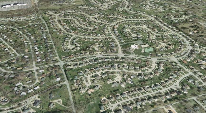
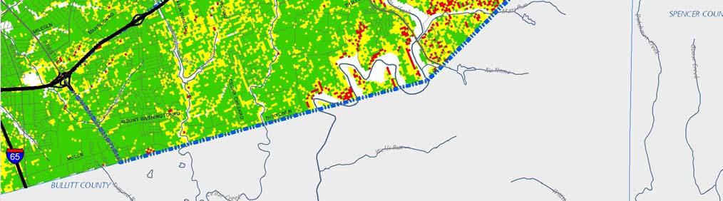
7 Study Area Floyds Fork Area Study
 Legend")


8 Building Permits ( ) Legend Multi-Family Residential Building Single-Family Residential Building Commercial Building


9 Why are Centers needed? Eliminate new stretches of linear commercial development that promote traffic congestion, air pollution, and inefficient use of infrastructure Provide compact areas to be served by multiple modes of transportation such as mass transit
10 To discourage this

11 And encourage this
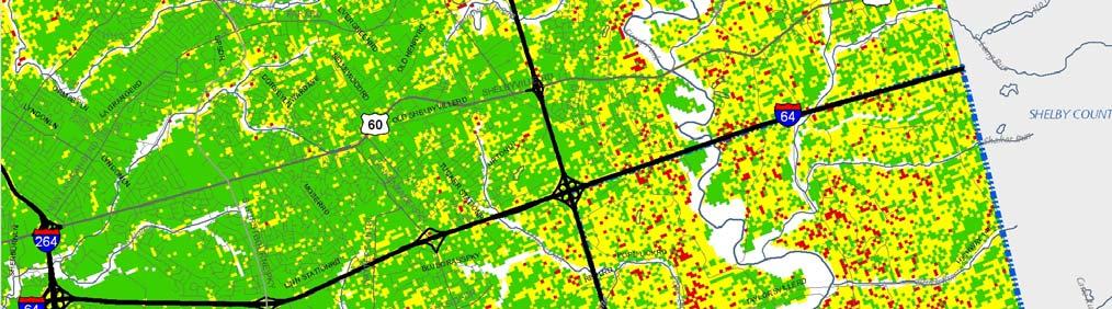
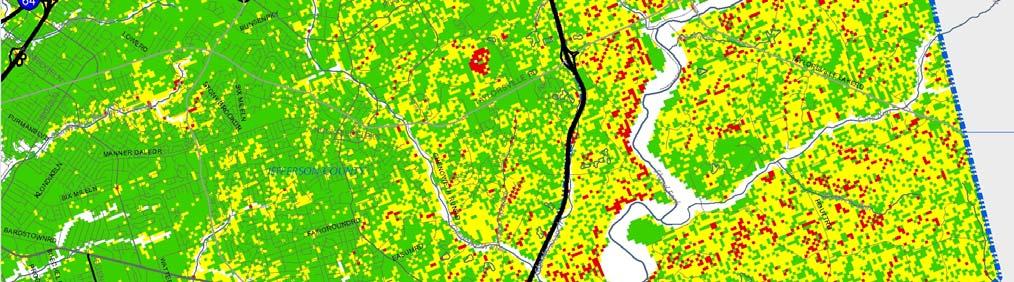
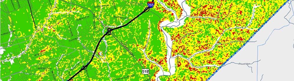
12 Suitability Analysis Existing Conditions and Trends Suitability Process Where should new centers be located? Population growth Slope and floodplain Proximity to existing and future parkland Transportation Access to residential development Access to employment centers Inventory Assessment
 Source: Louisville and")
13 Existing Conditions and Trends TAZ Boundaries (Transportation Analysis Zones) Source: Louisville and Jefferson County MSD

14 Existing Conditions and Trends Population Density Projections DU/Acre 2-8 DU/Acre 8 or more DU/Acre

15 Existing Conditions and Trends Slope and Floodplain Steep Slopes No Slope Floodway 100-Year Floodplain
16 Existing Conditions and Trends Slope and Floodplain 20% or Greater 5-20% 0-5%
 Future")
17 Existing Conditions and Trends Existing and Future Parkland Public (21 st Century and Metro Parks) Future Fund Other


18 Existing Conditions and Trends Proximity to Existing and Future Parkland 0-1/4 Mile ¼-½Mile ½ - 2 Miles or Greater

19 Existing Conditions and Trends Transportation Improvements Potential Interchange Improvements Proposed Road Improvements

20 Existing Conditions and Trends Residential Development Multi-Family Residential Single-Family Residential Proposed Single-Family

21 Existing Conditions and Trends Access to Residential Development 8 Miles or Greater 2-8 Miles 0-2 Miles

22 Existing Conditions and Trends Employment Centers Suburban Workplace Form Districts

23 Existing Conditions and Trends Access to Employment Centers 20 Miles or Greater 8-20 Miles 0-8 Miles

24 Suitability Analysis Existing Conditions and Trends Suitability Process Where should new centers be located? Population growth Slope and floodplain Proximity to existing and future parkland Transportation Access to residential development Access to employment centers Inventory Assessment

25 Metro Center Suitability and Location Process Inventory Assessment Assessment Metro Center Suitability Metro Center Location
26 Metro Center Suitability and Location High Suitability Medium Suitability Low Suitability Population growth (density) 2030 Slope and floodplain Proximity to existing and future parkland Access to residential development via roadway network Access to employment centers via roadway network Excludes developed areas, parkland, and floodplain
27 Metro Center Suitability and Location High Suitability Medium Suitability Low Suitability Fisherville Billtown Road at I-265 Bardstown Road at I-265 Cooper Chapel Road at Bardstown Road
28 Metro Center Suitability and Location Public (21 st Century and Metro Parks) Future Fund Other Fisherville Billtown Road at I-265 Bardstown Road at I-265 Cooper Chapel Road at Bardstown Road
 Residential")
29 Existing Regulations Zoning Commercial Commercial Manufacturing Industrial Office/Residential Planned Research/Office Rural Residential Residential Single Family (R-4) Residential Multi-Family


30 Existing Regulations Typical 4-5 Units/Acre Street Patterns Residential Single-Family R-4 Permitted Uses include: Agricultural Single-Family Dwellings Libraries, Schools, & Other Institutions Min Lot Size: 9,000 SF Max Dwellings per Acre: 4.84 Source: Visualizing Density, 2007 by the Lincoln Institute of Land Policy, Julie Campoli, and Alex S. MacLean
31 Existing Regulations Form Districts Campus Neighborhood Regional Center Suburban Marketplace Corridor Suburban Workplace Town Center Village / Village Center Downtown Traditional Marketplace Corridor Traditional Neighborhood Traditional Workplace

32 Existing Regulations Form Districts Campus Neighborhood Regional Center Suburban Marketplace Corridor Suburban Workplace Town Center Village / Village Center Downtown Traditional Marketplace Corridor Traditional Neighborhood Traditional Workplace

33 Existing Regulations Form Districts Campus Neighborhood Regional Center Suburban Marketplace Corridor Suburban Workplace Town Center Village / Village Center Downtown Traditional Marketplace Corridor Traditional Neighborhood Traditional Workplace
34 Existing Form Districts Neighborhood Form District Calls for a mix of retail, institutional, and other neighborhood-serving nonresidential uses in activity centers Little or no guidance for activity center size and location Contextual setback requirements for infill development Design standards otherwise limited compared to Village and Town Center form districts

35 Existing Form Districts Neighborhood Form District

36 Existing Form Districts Neighborhood Form District

37 Existing Form Districts Neighborhood Form District
38 Existing Form Districts Village / Village Center Form District Development in the center of a village offering goods and services at a scale that is appropriate for nearby residential area Surrounding residential area covered by Village Form District Outlying Typical of small communities developed prior to 1940 (e.g., Anchorage, Eastwood) Contextual setback and height requirements for infill development Design standards more extensive than Neighborhood form district but could be more comprehensive in scope
, Middletown Village Center (bottom) Palmer Square")
39 Existing Form Districts Village / Village Center Form District Fairdale Village Center (top), Middletown Village Center (bottom) Palmer Square Princeton, NJ
, Middletown Village Center (bottom) Merchant s Square Williamsburg,")
40 Existing Form Districts Village / Village Center Form District Fairdale Village Center (top), Middletown Village Center (bottom) Merchant s Square Williamsburg, VA

 Merchant s Square")
41 Existing Form Districts Village / Village Center Form District Fairdale Village Center (top), Middletown Village Center (bottom) Merchant s Square Williamsburg, VA
42 Existing Form Districts Town Center Form District Compact center with a mix of moderately intense commercial, civic, office, and residential uses focused on an identifiable core Floor space between 100,000 sf and 400,000 sf to serve market area of 25,000 to 75,000 Build-to line/maximum front yard setback and contextual height requirements Contextual setback and height requirements for infill development Design standards more extensive than Neighborhood form district but could be more comprehensive in scope
43 Existing Form Districts Town Center Form District St. Matthews Town Center (top), Ferncreek Town Center (bottom) Market Common at Clarendon Arlington, VA
, Ferncreek Town Center (bottom) Shirlington")
44 Existing Form Districts Town Center Form District St. Matthews Town Center (top), Ferncreek Town Center (bottom) Shirlington Village Arlington, VA
 Conservation Easements Purchase of")

45 Action Tools Conservation Subdivision Transfer of Development Rights (TDR) Conservation Easements Purchase of Development Rights Design Standards Plumsock at Willistown Conservation Subdivision Chester County, PA Source: Natural Lands Trust

")

46 Action Tools Conservation Subdivision Transfer of Development Rights (TDR) Conservation Easements Purchase of Development Rights Design Standards


 Easements")

47 Action Tools Conservation Subdivision Transfer of Development Rights (TDR) Conservation Easements Purchase of Development Rights Design Standards


48 Action Tools Conservation Subdivision Transfer of Development Rights (TDR) Conservation Easements Purchase of Development Rights Design Standards

49 Project Overview, Suitability Analysis, & Form Districts July 29, 2008 Discussion & Questions
The Floyds Fork Area Plan
 The Floyds Fork Area Plan Growth Framework and Design Principles Presented by: Wallace Roberts & Todd, LLC March 24, 2009 Ted Wathen / Quadrant Agenda Project overview and purpose Growth framework Design
The Floyds Fork Area Study A Framework for Growth
 The Floyds Fork Area Study A Framework for Growth Planning Committee 7/8/10 City of Parks 2 Growth Pattern REZONINGS (1976 2007) 1976 1983 1984 1991 1992 1999 2000 2007 1976-1983 3 Growth Pattern REZONINGS
The Floyds Fork Area Study A Framework for Growth
 The Floyds Fork Area Study A Framework for Growth 2 21 st Century Parks Master Plan: The Fork 3 Neighborhood Development Area Policy Recommendations 1. Create incentives to promote infill of existing development
E. RURAL COMMERCIAL/INDUSTRIAL PARK MODEL
 E. RURAL COMMERCIAL/INDUSTRIAL PARK MODEL 1. PURPOSE The purpose of the Rural Commerce/Industrial Park Model is to provide parameters within which a grouping of business buildings with parking, loading
Proposed Comprehensive Plan Strategies DRAFT for discussion June 28, 2017
 Proposed Comprehensive Plan Strategies DRAFT for discussion June 28, 2017 Land Use Rural Areas Refine the Farm and Forest area (FF) Update FF boundaries to account for existing lots less than five acres
Communities Plan. Parkland-Spanaway-Midland. LUAC Review of Draft Policies
 Parkland-Spanaway-Midland Communities Plan LUAC Review of Draft Policies Presented by: Tiffany O Dell, Senior Planner Planning & Public Works Tiffany.Odell@co.pierce.wa.us 253-798-6859 November 1, 2017
Planning Academy MARCH 8, 2015
 Planning Academy MARCH 8, 2015 Overview of Growth Management in Albemarle County Comprehensive Plans, Planning Initiatives Major Milestones Key Policies History Comprehensive Plan should precede Zoning
LAND USE ELEMENT. Purpose. General Goals & Policies
 LAND USE ELEMENT Purpose This Land Use Element contains the goals and policies necessary to support the City s responsibility for managing land resources and guiding development through implementing regulations,
Dwelling Units Max 12 dwelling units per acre/min 8 dwelling units per acre. Development Mix 80% non residential/20% residential
 13. OSTEEN LOCAL PLAN Background: The Osteen Local Plan area is located in southwest Volusia County along the SR 415 corridor between Lemon Bluff Road and Acorn Lake Road and includes 3,990 acres. The
Urban Development Areas Bedford County
 5 Urban Development Areas Bedford County UDA Needs Profile: All UDAs Bedford County has designated two UDAs: areas just outside the Bedford City Limits (generally to the south and east of the city) and
Chapter 1 Vision Statement & Goals
 Chapter 1 Section 1.1 Section 1.2 Section 1.3 Section 1.4 Section 1.5 Introduction Vision Statement Visioning Exercise Prioritization of Land Use Issues Goals of the Comprehensive Plan CHAPTER 1 SECTION
Subregion 4 Central Avenue-Metro Blue Line Corridor Transit-Oriented Development (TOD) Implementation Project. Community Meeting April 27, 2011
 Implementation Project. Community Meeting April 27, 2011") Subregion 4 Central Avenue-Metro Blue Line Corridor Transit-Oriented Development (TOD) Implementation Project Community Meeting April 27, 2011 Overview Introduction to Subregion 4 TOD Implementation Program
Subregion 4 Central Avenue-Metro Blue Line Corridor Transit-Oriented Development (TOD) Implementation Project Community Meeting April 27, 2011 Overview Introduction to Subregion 4 TOD Implementation Program
Obey Creek July 17, Vicinity Map. Concept Plan Submittal. No
 15/501 Fordham Blvd. 15/501 By-Pass To Downtown Chapel Hill Vicinity Map 0 1000 2000 FT Arlen Park DR. Bennett Road Mt. Carmel Church Rd. Southern Village Parkside Circle Market St. 15/501 Founder's Ridge
Chapter 10 IMPLEMENTATION RECOMMENDATIONS
 Chapter 10 IMPLEMENTATION RECOMMENDATIONS The recommended land use plan presented in the previous chapter provides a design for the attainment of the urban and rural development and open space preservation
DRAFT. Urban Development Areas Fairfax County. UDA Needs Profile: Tysons Corner 13% Location Characteristics. Socio-Economic Characteristics
 14 Urban Development Areas Fairfax County UDA Needs Profile: Tysons Corner Tysons Corner is located in Fairfax County, surrounded by the town of McLean to the east and Vienna on the west along I-495, the
SUSTAINABILITY KEY = MIXED-USE
 II - 16 Part II - Comprehensive Plan Elements 5. Land Use 5.1 Overview Land use in Union County has been shaped by its natural features ridges and valleys, rivers and streams, woodlands, and productive
Urban Development Areas Albemarle County
 1 Urban Development Areas Albemarle County UDA Needs Profile: All UDAs Albemarle County has two UDAs: the Pantops UDA located east of the Rivanna River and the City of Charlottesville, and Places 29 South,
Secrest Short Cut and Monroe Expressway Small Area Plan AUGUST 29, 2018
 Secrest Short Cut and Monroe Expressway Small Area Plan AUGUST 29, 2018 Background and Process Monroe Expressway will be open by the end of 2018 Union County and Indian Trail identified a need to revisit
Access Management: An Overview
 Figures 1-5 Below Evolution of development along a highway. In the early stages, land along the road is used for farming with little traffic generated. As time passes, the highway corridor becomes a de
ARTICLE 6: Special and Planned Development Districts
 ARTICLE 6: Special and Planned Development Districts 6-10 Traditional Neighborhood Development (TND) District 6-10.10 Purpose and Intent The Traditional Neighborhood Development (TND) District provides
Tri-County Transportation & Land Use Study. Steering Committee Meeting May 14, 2009
 Tri-County Transportation & Land Use Study Steering Committee Meeting May 14, 2009 Agenda Recap of Study Goals and Objectives Update on CV Land Use Model: Business as Usual (BAU) Growth Scenario Pros vs
The scale of intervention:
 The scale of intervention: Degree of specificity Is the TND district linked to a specific site? Is it linked to that site s master plan? If more broadly applicable, how will it relate to a variety of sites
Warren County/Bowling Green Focus 2030 Comprehensive Plan VOLUME 1 INDEX
 Appendix 5: Index VOLUME 1 INDEX A Aesthetics ES-6, FLU-15, FLU-17, FLU-24, NCR-7 Agricultural Base FLU-18, FLU-20 Agricultural Centers, Rural FLU-11 Agricultural District NCR-17-NCR-18 Agricultural Economy
Gold Line Bus Rapid Transit Transit Oriented Development (BRTOD) Helmo Station Area Plan
 Helmo Station Area Plan") Appendix F Gold Line Bus Rapid Transit Transit Oriented Development (BRTOD) Helmo Station Area Plan Introduction and Purpose of the Plan The Gold Line Bus Rapid Transit facility is an eleven-mile dedicated
Appendix F Gold Line Bus Rapid Transit Transit Oriented Development (BRTOD) Helmo Station Area Plan Introduction and Purpose of the Plan The Gold Line Bus Rapid Transit facility is an eleven-mile dedicated
Germantown Forward Status Report to the Planning Board M NCPPC
 Germantown Forward Status Report to the Planning Board Germantown Forward March 27, 2008 What s new? CCT alignment Capital Improvement Program Agency partners Water quality conditions Sustainability Design
Urban Development Areas Frederick County
 18 Urban Development Areas Frederick County UDA Needs Profile: All UDAs Frederick County, Virginia's northernmost county has two UDA s, surrounded by the City of Winchester and located adjacent to the
Asbury Chapel Subdivision Sketch Plan
 Asbury Chapel Subdivision Sketch Plan PART 1: PROJECT SUMMARY Applicant: NVR Inc. Project Size: +/- 76.13 acres Parcel Numbers: 02101112,02116101,02116112, 02116113 Current Zoning: Transitional Residential
Micco Park Village Development
 FOR SALE Call For Pricing Micco Park Village Development Proposed Project Property Details Micco Park Village Development PRICE Call For Pricing A monumental development opportunity of a lifetime! The
CHAPTER 4 FUTURE LAND USE AND URBAN SERVICES DISTRICTS
 CHAPTER 4 FUTURE LAND USE AND URBAN SERVICES DISTRICTS Introduction This chapter discusses how Benzie County should grow and change in the future. A community can grow and change in many different ways.
Westbound: A One-day Exploration of Growth
 Westbound: A One-day Exploration of Growth Frog Pond Area 2018 UGB Expansion Proposal June 13, 2018 Growing Out: UGB Asks Four cities submitted proposals to expand greater Portland s urban footprint by
IMPLEMENTING SOMERSET COUNTY S INVESTMENT FRAMEWORK
 IMPLEMENTING SOMERSET COUNTY S INVESTMENT FRAMEWORK SMART CONSERVATION THROUGH SMART GROWTH NJ LAND CONSERVATION RALLY March 22, 2014 Laurette Kratina, PP, AICP, Supervising Planner Somerset County Planning
Innovative Land Use Techniques
 Innovative Land Use Techniques A Handbook for Sustainable Development Eric Williams, Assistant Administrator, NHDES Carolyn Russell, Principal Planner, NHDES Cliff Sinnott, Executive Director, RPC Jill
Chapter IV: Development Pattern
 Chapter IV: Development Pattern Introduction The 2002 Prince George s County Approved General Plan designates three growth policy tiers Developed, Developing, and Rural as well as three center designations
Gloucester County s Comprehensive Plan. The Community Connection
 Gloucester County s Comprehensive Plan The Community Connection Current Comp Plan Adopted in 1991 with a 20 year planning horizon Updated in 1995 with Part V- Implementation Recommendations and Appendix
LAND USE MODEL UPDATE. Planning and Land Use Advisory Committee Meeting #2 September 4, 2014
 1 LAND USE MODEL UPDATE Planning and Land Use Advisory Committee Meeting #2 September 4, 2014 2 Presentation Outline Introduction and Recap Model Process Study Design Place Types Suitability Factors 3
Improve Neighborhood Design and Reduce Non Point Source Water Pollution
 HOW TO Planning Guide Improve Neighborhood Design and Reduce Non Point Source Water Pollution This document was funded by a grant from the New Hampshire Coastal Program with funding from the National Oceanic
LAND USE DESIGNATIONS AND ZONING CLASSIFICATIONS
 LAND USE DESIGNATIONS AND ZONING CLASSIFICATIONS One of the most significant issues addressed within the community plan process is land use. How land is utilized within a community directly affects the
Sorted citizen input comments in review of Blount County plans July, August, and September 2007
 Sorted citizen input comments in review of Blount County plans July, August, and September 2007 The following presents sorted citizen input comments from three sessions held in July, August and September
TABLE OF CONTENTS. Transportation Chapter 1 - Introduction and Purpose of Planning to 1-3. Utilities
 Chapter 1 - Introduction and Purpose of Planning... 1-1 to 1-3 Pennsylvania Municipalities Planning Code (Act 247)...1-1 Previous County Planning Activities...1-1 Objectives of the Plan...1-2 Elements
The Floyds Fork Area Study
 The Floyds Fork Area Study A Framework for Growth Prepared by The Floyds Fork Area Study A Framework for the Future October 2010 Prepared by ACKNOWLEDGEMENTS Louisville Metro Government Jerry Abramson,
Section 3: Land Use M C H E N R Y K A N E. Figure 3.1: Potential Future Municipal Boundaries. Future Municipal Boundaries. County Land Use Plans
 Section 3: Land Use Figure 3.1: Potential Future Municipal Boundaries Land use and transportation are intertwined; yet, land use and transpor- tation planning are often undertaken as separate disciplines.
Draft Cary Community Plan Review Part 3: Shop, Engage, Serve, Special Area Plans, Other Updates. October 27, 2015 Police Department Training Room
 Draft Cary Community Plan Review Part 3: Shop, Engage, Serve, Special Area Plans, Other Updates Committee for the Future October 27, 2015 Police Department Training Room AGENDA 1. Welcome and Call to Order
Community Open House March 26 th, 2018
 Community Open House March 26 th, 2018 Open House Agenda 1. Overview of Planning Process What we heard 2. Future Land Use Policy 3. Priority Growth Areas 4. Plan Elements Making it happen What is a Comprehensive
4: THE FRAMEWORK PLAN
 4: THE FRAMEWORK PLAN The American Transect. Drawing by James Wassell FRamework Plan: Purpose and Philosophy The Framework Plan is a land use policy map intended to provide guidance to Boone s leaders
SUSSEX COUNTY COMPREHENSIVE PLAN COUNTY PLANNING AND ZONING COMMISSION WORKSHOP
 SUSSEX COUNTY COMPREHENSIVE PLAN COUNTY PLANNING AND ZONING COMMISSION WORKSHOP August 21, 2017 TODAY S WORKSHOP Public Comment Utilities Update Economic Development Update Future Land Use Discussion Public
ALBEMARLE COUNTY CODE CHAPTER 18 ZONING SECTION 20A NEIGHBORHOOD MODEL - NMD
 CHAPTER 18 ZONING SECTION 20A NEIGHBORHOOD MODEL - NMD Sections: 20A.1 PURPOSE AND INTENT 20A.2 STATUS AS A PLANNED DEVELOPMENT DISTRICT 20A.5 CODES OF DEVELOPMENT 20A.6 PERMITTED USES 20A.7 RESIDENTIAL
CITY OF GRIDLEY 2030 General Plan
 I TABLE OF CONTENTS Page INTRODUCTION... 1 Relationship to Other Elements... 1 Areas Covered by the... 2 Planned Growth Area... 5 BUILDOUT ESTIMATES... 9 Buildout in the Planned Growth Area... 10 Buildout
Metro. Activity Center Design Guidelines. Recommendations For Developing Focused, Mixed-Use Commercial/Residential Centers
 Metro Activity Center Design Guidelines Recommendations For Developing Focused, Mixed-Use Commercial/Residential Centers Metro Activity Centers What is a MAC? Legacy, the adopted guide for the future growth
5 Land Use Element49
 5 Land Use Element 49 City of Forney - Comprehensive Plan Land Use Introduction Forney s Comprehensive Plan is a guide for physical and economic development in the City of Forney over the next 20-years.
VILLAGE OF CLEMMONS PLANNING BOARD DRAFT STAFF REPORT
 VILLAGE OF CLEMMONS PLANNING BOARD DRAFT STAFF REPORT PETITION INFORMATION Docket # C-226 Staff Megan Ledbetter Petitioner(s) JBJH Properties, LLC Owner(s) JBJH Properties, LLC Subject Property 5892-49-1766
Learning from Other Communities Western Nassau Heritage Preservation Committee Nassau County Planning + Zoning Board May 1, 2018
 Learning from Other Communities Western Nassau Heritage Preservation Committee Nassau County Planning + Zoning Board May 1, 2018 Overview ULI Report References Other Florida Communities Communities Outside
COMMUNITY DESIGN. GOAL: Create livable and attractive communities. Intent
 COMMUNITY DESIGN Intent An attractive, well-designed County will attract quality development, instill civic pride, improve the visual character of the community, and create a strong, positive image for
Transportation Working Team Duane Diggs, Co-Chair (VOICE Buffalo) Kelly Dixon, Co-Chair (GBNRTC) Paul Ray, Facilitator (UB Regional Institute)
 Kelly Dixon, Co-Chair (GBNRTC) Paul Ray, Facilitator (UB Regional Institute)") towards a more sustainable Buffalo Niagara Transportation Working Team Duane Diggs, Co-Chair (VOICE Buffalo) Kelly Dixon, Co-Chair (GBNRTC) Paul Ray, Facilitator (UB Regional Institute) Agenda Welcome,
towards a more sustainable Buffalo Niagara Transportation Working Team Duane Diggs, Co-Chair (VOICE Buffalo) Kelly Dixon, Co-Chair (GBNRTC) Paul Ray, Facilitator (UB Regional Institute) Agenda Welcome,
A citizen s guide to the. Comprehensive Plan. City of Lakeville, Minnesota 1
 A citizen s guide to the Comprehensive Plan 2008 City of Lakeville, Minnesota 1 Introduction The City of Lakeville completed an update of its Comprehensive Plan in 2008. A comprehensive plan is a tool
Land Use & Transportation Primer
 Land Use & Transportation Primer Presented By Smitha Vijayan Center for Urban Transportation Studies University of Wisconsin-Milwaukee Role of Local Government Land use decision-making power mostly given
NEW CASTLE COUNTY S ZONING DISTRICTS
 NEW CASTLE COUNTY S ZONING DISTRICTS This is general information about New Castle County s zoning districts. The information included is by no means exhaustive or complete. Before designing plans to develop
Future Land Use and Development Policies
 Future Land Use and Development Policies Introduction This section presents policies for future development and land use, given the consensus identified through the extensive public participation process.
Regions are Growing...
 Growing Strong Communities: The rural version of smart growth New Partners for Smart Growth Conference 2006 Matthew Dalbey January 27, 2006 U.S. Environmental Protection Agency Development, Community and
FUTURE DEVELOPMENT AREAS
 FUTURE DEVELOPMENT AREAS Refer to the Future Development Map on Page 2. Suburban Residential (Less than 3 units/acre) Suburban Residential neighborhoods form the backbone of Smyrna. While growth and redevelopment
TRANSPORTATION AND LAND USE
 CHAPTER 10 TRANSPORTATION AND LAND USE Transportation and land use are intimately linked. The expansion of a highway typically spurs housing, employment growth and land development in the communities that
IMPLEMENTATION STRATEGIES. In This Chapter. Goals & Strategies 182 Project List 183 Future Land Use 186 CHAPTER 11 IMPLEMENTATION STRATEGIES
 In This Chapter Goals & Strategies 182 Project List 183 Future Land Use 186 11 IMPLEMENTATION STRATEGIES NORTH AUGUSTA, SC 2017 COMPREHENSIVE PLAN 179 Individual commitment to a group effort that is what
Welcome! to Keller Town Hall
 Welcome! to Keller Town Hall Keller Town Center Planning a New Downtown What is Keller Town Center? A new, growing downtown district planned as an urban village A combination of retail and office spaces,
GENERAL LAND USE POLICIES
 GENERAL LAND USE POLICIES The County will: GOALS AND OBJECTIVES 7.1 Fiscal Distribute the designation of land uses to balance the costs of providing public services and facilities with generating public
Living in Albemarle County s Urban Places
 Living in Albemarle County s Urban Places ALBEMARLE COUNTY, VIRGINIA A Closer Look at Albemarle s Approach to Managing Growth and Creating Quality Urban Environments www.albemarle.org Page 2 Living in
Project Profile BAR HARBOR
 1 BAR HARBOR The Bar Harbor Master Plan merges community vision with design guidelines to preserve the unique character of Bar Harbor Village. PROJECT SUMMARY Overview: The economic vitality of Bar Harbor
Silver Line CPAM UPDATE. Transportation and Land Use Committee October 14, 2016
 Silver Line CPAM UPDATE Transportation and Land Use Committee October 14, 2016 Purpose Recap Project History and Map Changes Provide Overview of CPAM Components Discuss Transportation Impacts Discuss Fiscal
4.1.3 LAND USE CATEGORIES
 4.1.3 LAND USE CATEGORIES a. City Center District The City Center District incorporates the existing character and mix of uses in downtown Belmont to encourage redevelopment and new development in keeping
Guiding Principles, Objectives, Strategies and Policies
 Guiding Principles, Objectives, Strategies and Policies Section 1 Introduction These Guiding Principles were adopted as part of the 1999 Athens-Clarke County Comprehensive Plan and are carried over, in
City of Woodinville Planning Commission Study Session. Development Regulations 101: An Overview of Specific Regulatory Items To Help You in 2012
 City of Woodinville Planning Commission Study Session Development Regulations 101: An Overview of Specific Regulatory Items To Help You in 2012 Development Regulations 101 Overview of the Different Zones
Public Meeting March 10 th 2011
 Public Meeting March 10 th 2011 Agenda 6:00-6:15 6:15-7:00 7:00-8:00 8:00-8:30 8:30-9:00 9:00 Welcome and Introductions Presentation» Project Overview» Recap Existing Conditions / Issues & Opportunities»
PART 1: PROJECT SUMMARY. The application is Attachment A. The site plan is Attachment B.
 Belleterre Subdivision Sketch Plan Town Board 8.7.17 Belleterre Subdivision Sketch Plan PART 1: PROJECT SUMMARY Applicant: Bowman Development Project Size: +/- 20.85 acres Parcel Number: 01115104 and 01115121
CHARLES PUTMAN CHARLES PUTMAN AND ASSOCIATES, INC
 MEMORANDUM CHARLES PUTMAN & ASSOCIATES, INC. LAND DEVELOPMENT CONSULTANTS PLANNING ZONING PERMITTING 4722 NW Boca Raton Boulevard, Suite C-106 Boca Raton, Florida 33431 Phone: 561/994-6411 FAX: 561/994-0447
New Town Mixed Use District
 New Town Mixed Use District Montgomery County Planning Commission 2009 Annual Conference PA Chapter of the American Planning Association October 6, 2009 What is NTMU? More urban style of development Complementary
Ten Mile Creek Planning Area
 PLANNING AREA POLICIES TEN MILE CREEK Ten Mile Creek Planning Area Location and Context The Ten Mile Creek Planning Area ( Ten Mile Creek area ) is located south of the current Boise AOCI, generally south
SECTION II SECTION II STATEMENT OF GOALS, OBJECTIVES, PRINCIPLES, ASSUMPTIONS, POLICIES AND STANDARDS
 STATEMENT OF GOALS, OBJECTIVES, PRINCIPLES, ASSUMPTIONS, POLICIES AND STANDARDS 1 2 STATEMENT OF GOALS, OBJECTIVES, PRINCIPLES, ASSUMPTIONS, POLICIES AND STANDARDS INTRODUCTION The New Jersey Municipal
FUTURE LAND USE PLAN 7
 FUTURE LAND USE PLAN 7 The recommendations of each of the preceding chapters can be combined to present an overall Future Land Use Plan for Wilton. The Future Land Use Plan, presented on the following
COPLAY BOROUGH COMPREHENSIVE PLAN
 COPLAY BOROUGH COMPREHENSIVE PLAN Lehigh County, Pennsylvania Adopted by Coplay Borough Council on May 11, 2010 Urban Research and Development Corporation Bethlehem, PA with Keystone Consulting Engineers,
1. FUTURE LAND USE ELEMENT Goals, Objectives, and Policies
 1. Goals, Objectives, and Policies The has limited vacant land remaining for new development. Redevelopment is anticipated to represent nearly all development activity within the City. More City residents
REVIEW AND EVALUATION OF REGIONAL LAND USE
 REVIEW AND EVALUATION OF REGIONAL LAND USE AND TRANSPORTATION SCENARIOS #220831 Environmental Justice Task Force October 7, 2014 VISION 2050 Process Development of Guiding Vision for Land Use and Transportation
Future Land Use Pottstown Metropolitan Regional Comprehensive Plan. Future Land Use
 Future Land Use Pottstown Metropolitan Regional Comprehensive Plan Chapter 5 Future Land Use New housing in Upper Pottsgrove Township Farmland in North Coventry Township Abandoned building in Pottstown
2. Would the proposed project comply with the Land Use map? 3. Would the proposed project require a rezoning? 4. What is the proposed zoning district?
 TOWN OF CHAPEL HILL Planning and Sustainability Department 405 Martin Luther King Jr. Blvd. Chapel Hill, NC 27514 www.townofchapelhill.org phone (919) 968 2728 Concept Plans are intended to be an opportunity
BROOKHILL NEIGHBORHOOD MODEL ZONING MAP AMENDMENT PREFACE TO APPLICATION
 BROOKHILL NEIGHBORHOOD MODEL ZONING MAP AMENDMENT PREFACE TO APPLICATION June 15, 2015 Revised: August 1, 2016 I. VISION Brookhill is a proposed community based upon the principles of Albemarle County
SMART Plan East-West Corridor Land Use Scenario & Visioning Planning
 SMART Plan East-West Corridor Land Use Scenario & Visioning Planning Implementation Plan Charrettes January 2018 Presentation Outline 1. SMART Plan and Land Use Visioning Study Overview 2. Live Polling
LEED-ND 101: Practical Strategies for Achieving Sustainability Goals. Travis Parker Lakewood Planning Director
 LEED-ND 101: Practical Strategies for Achieving Sustainability Goals Travis Parker Lakewood Planning Director Metro Vision Idea Exchange Oct 11, 2012 West Corridor Stations West Corridor Overview West
PART 1: PROJECT SUMMARY. Proposed Land Use: 120 single-family lots. The application is Attachment A. The site plan is Attachment B.
 PART 1: PROJECT SUMMARY Applicant: JBH Development, LLC and Hopper Communities, INC Project Size: +/- 80.48 acres Parcel Number: 01513107, 01513108, 01513109, 01513113, 01513120, 01513121, 01513122, 01513124,
4-Town Comprehensive Plan DRAFT 7/30/07
 4-Town Comprehensive Plan DRAFT 7/30/07 Acknowledgements ning Committee Town of Harrisburg Norman Roof Randy Nicol Town of Martinsburg Terry Thisse Paul Kelly Town of Montague Jan Bagdanowicz Wendy Perry
TRANSIT ORIENTED DEVELOPMENT PINELLAS COUNTY MPO LIVABLE COMMUNITIES INITIATIVE PINELLAS COUNTY COMPREHENSIVE PLAN AMENDMENTS
 PINELLAS COUNTY MPO LIVABLE COMMUNITIES INITIATIVE MODEL LAND DEVELOPMENT CODE TRANSIT ORIENTED DEVELOPMENT PINELLAS COUNTY COMPREHENSIVE PLAN AMENDMENTS MPO Livable Communities Initiative Goal: Improve
Population, Housing, and Employment Analysis
 Population, Housing, and Employment Analysis Reviewed housing development patterns, trends, needs, affordability, and estimated employment and population capacity at full build out. Total 28,200 people
Rapid City Planning Commission Rezoning Project Report
 Rapid City Planning Commission Rezoning Project Report July 21, 2016 Applicant Request(s) Case # 16RZ022 Rezoning from Office Commercial District to Light Industrial District Companion Case(s): 16RZ023-Rezoning
Town of Liberty, NY COMPREHENSIVE PLAN & ZONING UPDATES
 Town of Liberty, NY S Public Informational Meeting October 4, 2016 High School Auditorium Welcome Thank you for coming tonight. Agenda Part I Overview of Proposed Changes What is Being Prepared Anticipated
Chapter 6: Community Character
 Chapter 6: Community Character The term "community character" covers a broad spectrum of concerns. First and foremost, community character is a visual concept. In Long Grove, however, community character
Pantops Master Plan Update 2018
 Pantops Master Plan Update 2018 Focus Area Topic Meeting #1 Land Use & Development Area Boundary North of I-64 February 26, 2018 Pantops Master Plan Update 2018 Focus Area Public Meetings: Kickoff Meeting
CHAPTER 1. Ms. Guajardo s Class - Central Elementary CH 1 1
 INTRODUCTION CHAPTER 1 Ms. Guajardo s Class - Central Elementary CH 1 1 1.1 SETTING South Centre City is a linear corridor south of Downtown Escondido paralleling Centre City Parkway and South Escondido
Gruene River Place PDD CONCEPT PLAN AND DEVELOPMENT STANDARDS
 Gruene River Place PDD CONCEPT PLAN AND DEVELOPMENT STANDARDS GRUENE RIVER PLACE PLANNED DEVELOPMENT DISTRICT As per Section 3.5, Chapter 144 of the City s Zoning Ordinance To: The Planning & Zoning Commission
Citizen Comment Staff Response Staff Recommended Revision Planning Committee
 Citizen Comment Staff Response Staff Recommended Revision Planning Committee Area No. 1: Owner desires retail land uses. Area No. 1a: Owner of two small parcels adjacent to Area No. 1 desires retail land
Growth Management Planning in the Central Puget Sound Region. Today s Presentation. Puget Sound Region. New Partners for Smart Growth
 Growth Management Planning in the Central Puget Sound Region New Partners for Smart Growth Denver, CO January 2006 Today s Presentation Regional growth management in central Puget Sound, WA Regional geographies
MORRISVILLE TRANSPORTATION PLAN TOWN COUNCIL PRESENTATION AUGUST 22, 2017
 TOWN COUNCIL PRESENTATION AUGUST 22, 2017 SCENARIO PLANNING CORRIDORS Town Hall Drive Baseline + 2 McCrimmon Parkway Baseline + 2 NC 54 Baseline + 2 7 subregion model runs determining carrying capacity
Brian Madigan, RLA, CPESC Director Land Planning & Design
 Brian Madigan, RLA, CPESC Director Land Planning & Design bmadigan@gymodpc.com Architecture, Engineering & Land Surveying, DPC 18969 US Route 11 Watertown, New York 13601 T: (315) 788-3900 F: (315) 788-0668
CHAPTER 7: Transportation, Mobility and Circulation
 AGLE AREA COMMUNITY Plan CHAPTER 7 CHAPTER 7: Transportation, Mobility and Circulation Transportation, Mobility and Circulation The purpose of the Transportation, Mobility and Circulation Chapter is to
Future Land Use and Transportation
 Planning & Zoning Board Workshop Comprehensive Plan for Village of Estero Future Land Use and Transportation April 6, 2017 January Kick-off Meeting Public Input What do you like about Estero? Location