8.2 Sector 2 Kelburn Park
|
|
|
- Maximillian Jacobs
- 5 years ago
- Views:
Transcription

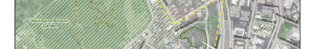
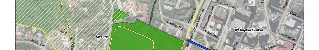
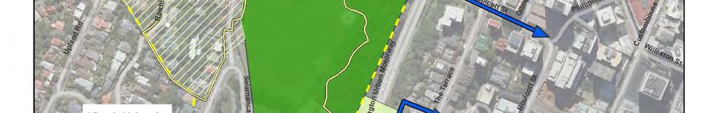
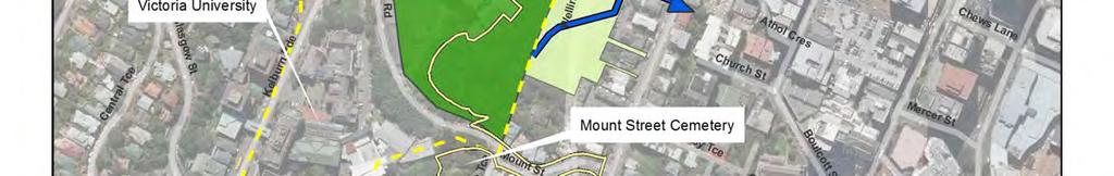
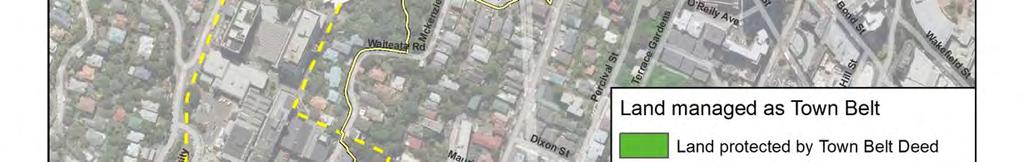
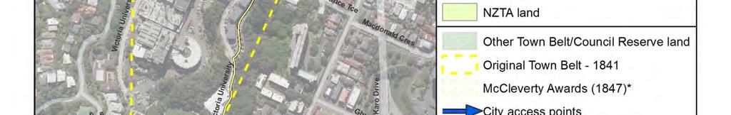
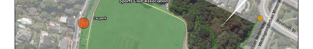
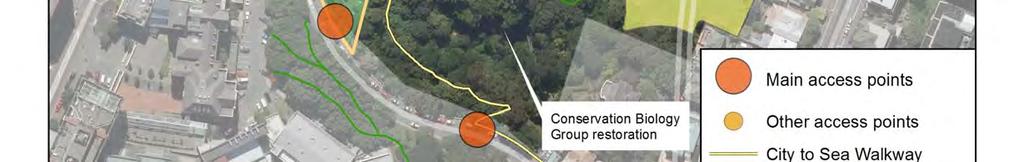
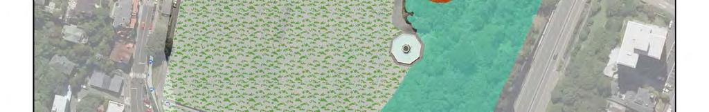
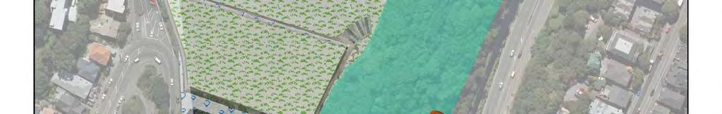
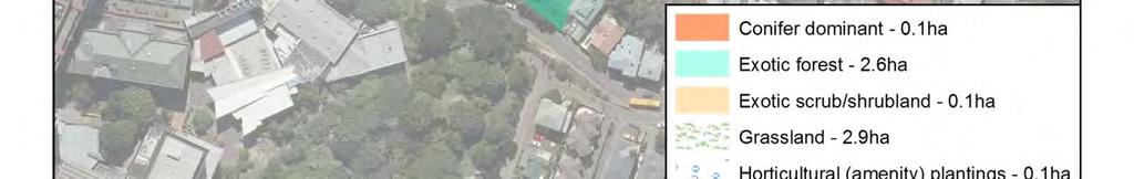
1 8.2 Sector 2 Kelburn Park Kelburn Park, near Victoria University Character and use Kelburn Park is a sector of the Town Belt, of a scale and character more like a suburban park. However, the woodland in the park is an unexpected pocket of 'natural' environment close to the city, with walking links between Kelburn, Victoria University and the central business district (Sector 2: context map). Kelburn is a typical Wellington suburb of winding streets and picturesque houses, easily accessible to visitors from the central city. Kelburn Park is located between Salamanca Road and the urban motorway. It is a remnant of the original Town Belt that ran from the Botanic Garden to Aro Valley and consists of three distinct areas: 1. The flat open sports ground has a suburban and formal character, which includes the sportsfield, croquet green and tennis and squash courts. A play area is at the northern end. 2. A woodland comprises mixed exotic and native species with a few large pine trees sloping steeply down to the urban motorway. 90.

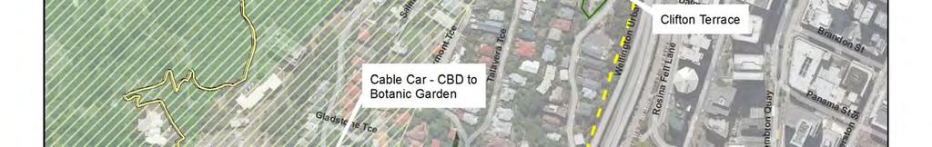
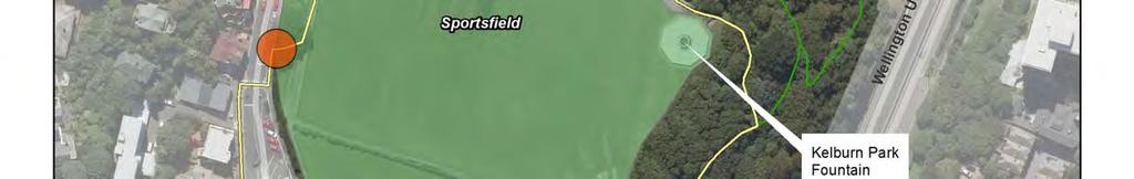
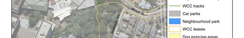
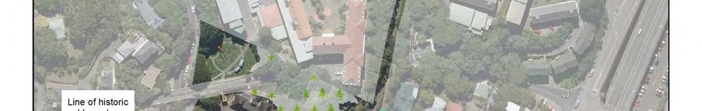
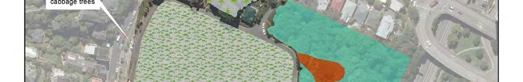
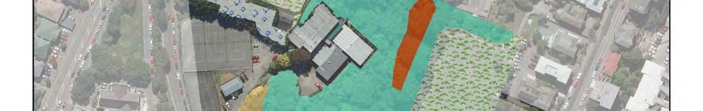
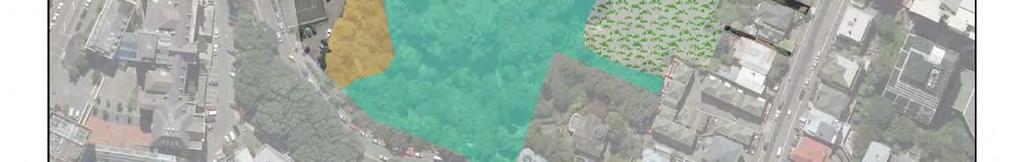
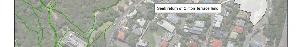
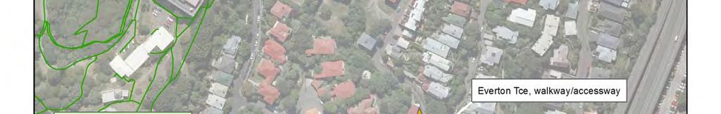
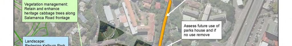
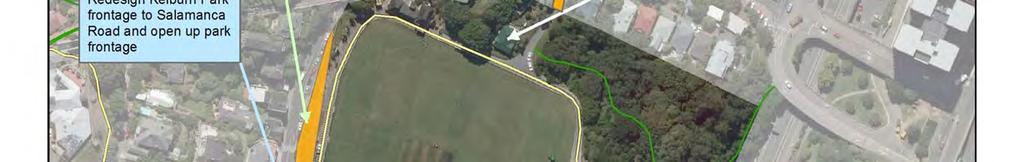
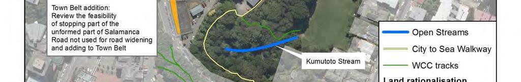
2 3. A small open park area is located over the motorway (the Terrace Tunnel land owned by the New Zealand Transport Agency). It is not part of the Town Belt but managed as part of Kelburn Park as a dog-exercise area. Kelburn Park is mainly used for formal recreation being an urban sport and recreation park close to the city and university. The City to Sea Walkway 50 passes through the park. This walkway is part of Te Araroa, the national walkway. The Wellington Cable Car passes across the north corner of Kelburn Park, above the ground Land addition and boundary rationalisation Policies Redefine by survey the portion of Salamanca Road from McKenzie Terrace to the Cable Car not required for future road widening so the road and Town Belt boundaries follow the future road alignment. This boundary rationalisation will involve taking land into the Town Belt and in some cases taking land out Formally add the access-way off Everton Terrace to the Town Belt The Council will initiate discussions with the Crown and Port Nicholson Block Settlement Trust over the future ownership, status and return of the Clifton Terrace land, and the New Zealand Transport Agency land designated for motorway purposes Much of the original Town Belt in this sector has been lost and taken for other purposes such as private residential housing and Victoria University. This sector includes a boundary rationalisation along Salamanca Road and adding the Everton Terrace access-way to the Town Belt. The Clifton Terrace land (former Correspondence School site), and the land designated for motorway purposes (including the park area over the Terrace Tunnel) are in this sector but are owned by the Crown and not covered by this management plan. Please refer to Table 2 at the end of this sector for a complete list of Town Belt land additions and removals and boundary adjustments. It is proposed that ha of land comprising the Everton Terrace access-way be managed as Town Belt under this plan. (Sector 2: context map). Kelburn Park and Victoria University Note most of the cabbage trees, embankment and pavilion are on unformed legal road. Clifton Terrace land (former Correspondence School site): This land is located on the corner of Clifton Terrace and San Sebastian Road. The land was part of the original Town Belt, however it was never included in the 1873 Trust Deed. 50 A 12km walkway from Bolton Street Memorial Park to Island Bay 91.
3 This land is subject to the RFR provisions of the Port Nicholson Block (Taranaki Whānui ki Te Upoko O Te Ika) Claims Settlement Act 2009, which gives mana whenua the right of first refusal if the Crown plans to dispose of the land. The acquisition history of this land is complex. In 1991 it was transferred to Landcorp for disposal. The Council opposed moves to sell this land on the basis that it sought the land for the Town Belt. The sale process was stopped in by the Minister of State-Owned Enterprises who asked for a full investigation into the history (acquisition and transfer) and that parties negotiate and sort out the differences. No further progress has been made. The land is now administered by Land Information New Zealand. The land has a driveway to two small flat areas on different levels, which are currently used for car parking, and a steep vegetated slope/road cut. There are some regenerating native and exotic species and mature trees around the perimeter of the site. It has become separated from existing Town Belt land but is contiguous with the green edge of the motorway on what is original Town Belt land. Given its location and topographical level (below the Botanic Garden and just above the motorway), the site by itself adds little value for strengthening the Town Belt s horseshoe shape but does provide important landscape qualities when assessed with the adjacent motorway lands. The mature trees and regenerating native plantings on the site provide landscape and ecological values. There are no known cultural values, but the land was part of the original Town Belt. The land is accessible and has linkages to other reserves or Town Belt areas through the walking tracks adjacent to the motorway. The street frontage and configuration of the site is on two levels and it is regularly used as a walking linkage between Talavera Terrace, San Sebastian Road and Clifton Terrace. Assessment of this land using the Town Belt acquisition criteria has concluded that it has values that need to be protected, in particular given its status as former Town Belt land. It is considered a high priority for addition to the Town Belt. The land is also used by Clifton Terrace School for car parking and any discussions with the Crown should recognise possible multiple community uses in the future. It is recommended that the Council start discussions with Port Nicholson Block Settlement Trust, the Ministry of Education, Clifton Terrace School and Land Information New Zealand about the future use and protection of this land. New Zealand Transport Agency land designated for motorway purposes: This land is the vegetated verge on the western side of the motorway from Bolton Street to Everton Terrace. The land is designated for motorway purposes or for better utilisation, in a number of different land parcels. It is Crown-owned land administered by the New Zealand Transport Agency. This vegetation and open space is visually significant especially when entering the central city along the motorway. The southern end of this land visually links with the north-eastern corner of Kelburn Park but doesn t connect to the Town Belt. The vegetation is of similar character to that of the Kelburn Park woodland and there is a walkway through the land to Bolton Street. There are no known ecological or cultural values. Although this land offers an important green link and entrance into the city, it would be a low priority for acquisition at market value for adding to the Town Belt. There is potential to improve linkages through this land and improve signs. New Zealand Transport Agency land above The Terrace Tunnel: The land is a secluded area of sloping mown grass overlooked by neighbouring houses and is next to Kelburn Park above the Terrace Tunnel. Access is off The Terrace and by steps near Club Kelburn. The land is described as motorway reserve and managed as a dog-exercise area. 92.
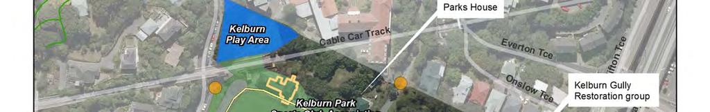
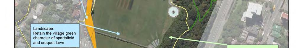
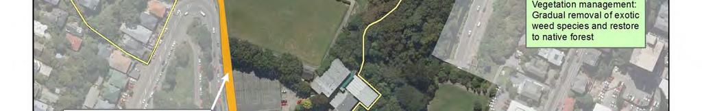
4 This land was not part of the original Town Belt. It is subject to the RFR provisions of the Port Nicholson Block (Taranaki Whānui ki Te Upoko O Te Ika) Claims Settlement Act 2009, which gives mana whenua the right of first refusal if the Crown plans to dispose of the land. This land is next to Kelburn Park and is perceived to be part of the park. Given its secluded location and lower topographical level it has a lower visual importance. However it offers a significant pedestrian link between Victoria University, Kelburn Park and the central city. The mown grass and seating area is used for passive recreation. The Council identifies this land as an important piece of accessible open space and the preference is to retain the status quo regarding ownership and management Landscape and ecological management Policies Maintain the mixed species character of the woodland, aiming for a gradual removal of weed species and a return to podocarp and broadleaf forest Retain and enhance the village green character of the sportsfield and croquet club Retain the existing character of amenity plantings and pohutukawa planting around the sports grounds Protect and manage the heritage cabbage trees between the sportsfield and Salamanca Road. Kelburn Park is isolated from other parts of the Town Belt. The Botanic Garden close by provides some ecological connectivity (Sector 2: landscape and existing vegetation map). The woodland area and open park above the motorway have the potential to be better integrated and will be considered together. The woodland area is visually significant given its closeness to the central business district (CBD) and provides easily accessible pedestrian links between Victoria University and the CBD. The area is a sheltered east-facing slope with a complementary character to the mixed deciduous/native woodland around Everton Terrace further north. Exotic species are primarily weedy species such as wattle and sycamore. In the past 15 years vegetation management has involved the removal of several large pine trees above the motorway with limited removal of other exotic trees. There has been limited replanting of natives primarily by two restoration groups: Kelburn Gully Restoration Group is working above Everton Terrace and focusing on replacing exotic trees with natives, particularly species attractive to native birds. Conservation Biology Group from Victoria University is planting natives in the area between the Squash Club and the dog exercise area Recreation Policies Open up the park frontage onto Salamanca Road Improve access to and information about the local park area above the motorway. 93.
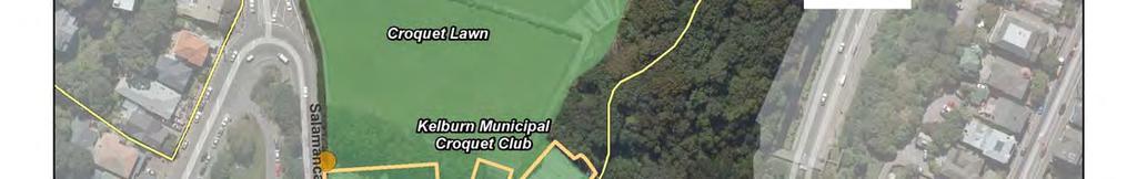
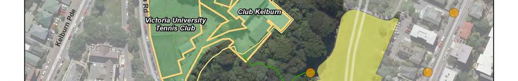
5 Improve walking links between Kelburn Park and the CBD, including signs Review long-term uses for the caretaker s house. The upper sports ground area has been developed for a range of mainly formal recreation facilities since 1908 (Sector 2: current uses maps). These include natural turf sportsfields used for summer and winter sport. In addition there are the following clubs: Kelburn Municipal Croquet Club leases the clubhouse and uses the croquet greens under an arrangement where the Council maintains the greens and they pay an annual fee. Kelburn Park Sports Club Association is made up of Victoria University football and cricket clubs and Hunters Rugby League club. Club Kelburn (formally NZ Squash Inc) is a major squash facility in Wellington. It is made up of 10 courts, a fitness club (gym), physiotherapy clinic and a pro shop. Victoria University of Wellington (Tennis Club) leases clubrooms and four outdoor courts. There is also a local playground due for renewal in 2017/2018. Walking tracks and a fitness trail pass through the woodland area, some of these are used for pedestrian access down to the city. There is a close association between Victoria University and the park. Several of the sports facilities are used by university students and considerable foot traffic is generated between the Weir House hall of residence, the Cable Car and the university. The area is poorly accessed with large hedges and gates preventing access to the park. Pedestrian access from the university is poor with no crossing nearby. The land above The Terrace, used as a dog-exercise area, has recently been upgraded by New Zealand Transport Agency as part of the Terrace Tunnel upgrade. This has a seating area and lookout at the northern end Encroachments There are no major access encroachments in this sector. 94.
6 95.
7 96.
8 97.
9 98.
10 Table 2: Town Belt additions, removals and boundary rationalisation Kelburn Park sector Site name Legal description and area Salamanca Road boundaries This is the portion of Salamanca Road, from McKenzie Terrace to the Cable Car. Description, location, current use The legal road boundaries of Salamanca Road, between McKenzie Terrace and the Cable Car, do not follow the actual road carriageway. In parts, particularly alongside the university tennis courts, the legal road encroaches onto the tennis courts and Kelburn Park. Further along, near the Cable Car, the actual road carriageway is on Town Belt. Previous policy Discussion, criteria assessment Recommendation Land covered by this TBMP The Town Belt Management Plan (TBMP) states: The Council shall have a Bill introduced to Parliament to regularise the legal status and unite the lands managed as Town Belt... (part 1, page 16). This strip of land is next to and part of the Kelburn Park precinct. Kelburn Park would be significantly altered if this strip of land was developed and used for another purpose. The land includes part of the university tennis courts, croquet greens and sportsfield of Kelburn Park. The historic row of cabbage trees along the park boundary are on legal road. The land appears to be part of the Town Belt. The portion of Salamanca Road, from McKenzie Terrace to the Cable Car, should be redefined by survey when future road widening takes place. This is legal road but should be managed consistently with TBMP policies. Access-way off Everton Terrace The land is described as an access-way, comprising ha, NZ Gazette 1928 page 700. This is a public access-way, linking Kelburn Park and Everton Terrace. It was original Town Belt land. This access-way and entrance into Kelburn Park, provides an important link from the university and Kelburn Park to the city. It has high recreation values, but low landscape or ecological values. It was part of the original Town Belt. The access-way should be added to the Town Belt. The encroachment off Everton Terrace will need to be resolved as part of this work. Yes Former Correspondence School site, Clifton Terrace This site is owned by the Crown and administered by Land Information New Zealand. It is included in the Port Nicholson Block Claims Settlement Act 2009 land schedule and the PNBST has the first right of refusal if the land is declared surplus. The legal description of this area is City of Wellington, Section 1 on survey office plan being land in CT 39D/487. It is zoned Open Space B in the Council s District Plan. Located on the corner of Clifton Terrace and San Sebastian Road, the site consists of a driveway up to a small flat area and a steep vegetated slope/road cut. There are some regenerating native and exotic species and mature trees around the perimeter of the site. Street frontage is poor. There is considerable acquisition history with this land. In 1991 it was transferred to Landcorp for disposal. The Council opposed moves to sell this land on the basis that it sought the land for the Town Belt. The sale process was stopped in 1994/95 by the Minister of State-Owned Enterprises who asked for a full investigation into the history (acquisition and transfer) and that parties negotiate and sort out the differences. The TBMP and TBRP identified the Clifton Terrace land as a significant area of open space that should be included as Town Belt land. The TBRP considered a range of options and outlined two: 1. Seek ownership for Town Belt purposes, subject to consultation with Māori. 2. Decide that the land is not particularly suitable for Town Belt purposes. The Policy identified option 1. It has become separated from existing Town Belt land but is contiguous with the green edge of the motorway on what is original Town Belt land. Given its location and topographical level (below the Botanic Garden and just above the motorway), the site by itself adds little value for strengthening the Town Belt s horseshoe shape but does provide important landscape qualities when assessed with the adjacent motorway lands. The mature trees and regenerating native plantings on the site provide landscape and ecological values. There are no known cultural values, but the land was part of the original Town Belt. The land is accessible and has linkages to other reserves or Town Belt areas through the walking tracks adjacent to the motorway. The street frontage and configuration of the site is on two levels and it is regularly used as a walking linkage between Talavera Terrace, San Sebastian Road and Clifton Terrace. Assessment of this land using the Town Belt acquisition criteria has concluded that it has values that need to be protected in particular given its status as former Town Belt. It is a high priority for addition to the Town Belt. The land is also used by Clifton Terrace School for car parking and any discussions with the Crown should recognise possible multiple community uses in the future. It is recommended that the Council start discussions with Port Nicholson Block Settlement Trust, the Ministry of Education, Clifton Terrace School and Land Information New Zealand about the future use and protection of this land. No Land held for motorway purposes, Western Designated for motorway purposes or for better utilisation, in a number of different This is vegetated verge along the western motorway edge from Bolton Street to Everton Terrace. It was identified in the TBMP 1995, as a potential addition to the Town Belt. This edge of vegetation and open space is visually significant, especially when entering the central city along the motorway. The southern end of The Council should not pursue acquisition of this land. 99. No
11 Motorway edge land parcels. It is Crown-owned land administered by the New Zealand Transport Agency. Site name Legal description and area Open space land above the Terrace Tunnel The land is described as motorway reserve. This is Crown-owned land and administered by the New Zealand Transport Agency. It is zoned Inner Residential in the Council s District Plan. Included in the PNBST Act Description, location, current use This land above the Terrace Tunnel is a secluded area of sloping mown grass overlooked by neighbouring houses. It is next to Kelburn Park and access is from The Terrace. It was not part of the original Town Belt. this land visually links with the north-eastern corner of Kelburn Park. It strengthens the green backdrop of the Town Belt where the original continuity of the Town Belt has been lost. Previous policy Discussion, criteria assessment Recommendation Land covered by this TBMP It was identified in the TBMP 1995 as a potential addition to the Town Belt. The plan identifies this area, described as 3c, (figure 2, page 5) as significant open space in a locality where the original continuity of the Town Belt has been lost. The land borders Kelburn Park and is perceived to be part of the park. Given its secluded location and lower topographical level it has a lower visual importance. However it offers a significant pedestrian link between Victoria University, Kelburn Park and the central city. The mown grass and seating area is used for passive recreation. The Council should have further discussions with the New Zealand Transport Agency over future management of this land. No, but management of this land will be consistent with the objective and policies of the TBMP. Policy 2 on page 8 states: The Council shall continue to maintain and manage the land above the motorway tunnel as part of Kelburn Park and negotiate for its addition to the Town Belt.
8.3 Sector 4 Brooklyn Hills
 8.3 Sector 4 Brooklyn Hills Wellington Town Belt on the Brooklyn Hills between Mt Cook and Brooklyn 8.4.1 Character and use This sector extends around the city-facing slopes below Brooklyn, from Mortimer
8.8 Sector 8 Hataitai Park
 8.8 Sector 8 Hataitai Park The recreation hub at Hataitai Park Note Badminton Hall at the top of picture and Velodrome at bottom centre. 8.8.1 Character and use The sector occupies the east face of the
Khandallah, Broadmeadows, Ngaio, Crofton Downs and Kaiwharawhara
 3 Management sector plans 3.1 Sector 1 Khandallah, Broadmeadows, Ngaio, Crofton Downs and Kaiwharawhara A unique feature of this sector is the harbour escarpment and the steep gullies off Onslow Road and
3 MANAGEMENT SECTOR PLANS
 SUBURBAN RESERVES MANAGEMENT PLAN 2015 I 37 3 MANAGEMENT SECTOR PLANS 3.1 SECTOR 1 Khandallah, Broadmeadows, Ngaio, Crofton Downs, Kaiwharawhara, Ngauranga Gorge A unique feature of this sector is the
Appendix H: Easement cross sections
 Appendix H: Easement cross sections SHARED PATH 1.5m FOOTPATH NATURE STRIP 7.3m CARRIAGEWAY 2.7m NATURE STRIP EXISTING PIPELINE 150mm DIA 5.0m (approx.) LOCAL ACCESS ROAD EXISTING PIPELINE 500mm DIA 2.7m
HOROWHENUA DEVELOPMENT PLAN June create a safe crossing for children moving to and from the school and other areas. 7.8 Ohau
 7.8 Ohau create a safe crossing for children moving to and from the school and other areas. Ohau has a traditional village form with a collective of school, church and reserve at the main road intersection.
Monte Cecilia Park DRAFT CONCEPT PLAN FEBRUARY 2015 AUCKLAND COUNCIL
 Monte Cecilia Park DRAFT CONCEPT PLAN FEBRUARY 2015 AUCKLAND COUNCIL 1 Site analysis and concept 1.1 Location Site Extent MT ALBERT RD HILLSBOROUGH RD BUDOCK RD MONTE CECILIA PARK KORMA RD HERD RD Figure
PART FOUR: IMPLEMENTATION NEW INITIATIVES
 PART FOUR: IMPLEMENTATION NEW INITIATIVES The new initiatives are specific projects or actions identified in Part Three, Policies. This section sets out the priorities for their implementation to assist
The horseshoe-shaped Wellington Town Belt as seen from Te Ahumairangi Hill Lookout
 1 Introduction The horseshoe-shaped Wellington Town Belt as seen from Te Ahumairangi Hill Lookout Wellington has a very beautiful natural setting by world standards. The inner city faces north and east
Types of Reserves. Recreational activities
 VALLEY FLOOR AND EASTERN HILLS Physical and ecological features Large, flat valley floor and river plain with intensive urban development Hutt River / Te Awa Kairangi and tributaries Waiwhetu Stream Eastern
LISMORE PARK, KELLY S FLAT, ALLENBY PARK, FAULKS TERRACE, DOMINI PARK & KENNEDY CRESCENT
 Attachment A: PROPOSED RESERVE MANAGEMENT PLAN FOR THE RECREATION RESERVES KNOWN AS: LISMORE PARK, KELLY S FLAT, ALLENBY PARK, FAULKS TERRACE, DOMINI PARK & KENNEDY CRESCENT WANAKA RECREATION RESERVES
GREENBANK DEVELOPMENT MASTERPLAN
 DEVELOPMENT MASTERPLAN POTENTIAL TRAIN STATION COMMUNITY CENTRE Greenbank will be a connected masterplanned community providing easy access to local and surrounding amenity. Affordable quality homes, green
H7 Open Space zones. (a) provide for the needs of the wider community as well as the needs of the community in which they are located;
 provide for the needs of the wider community as well as the needs of the community in which they are located;") H7. Open Space zones H7.1. Background The majority of land zoned as open space is vested in the Council or is owned by the Crown. However some areas zoned open space are privately owned. While the open
H7. Open Space zones H7.1. Background The majority of land zoned as open space is vested in the Council or is owned by the Crown. However some areas zoned open space are privately owned. While the open
BLACKHEATH SQUASH CLUB Blackheath Sports Club, Rectory Field, Charlton Road, London, SE7 7EY. Planning, Design and Access Statement
 Planning, Design and Access Statement Revised: 28 th Jan 2016 Peter Pendleton & Associates Ltd Introduction Planning permission will be sought for a refurbishment of existing courts and extension to provide
The management plan meets the requirements of the Reserves Act 1977.
 SUBURBAN RESERVES MANAGEMENT PLAN 2015 I 4 INTRODUCTION 1.1 PURPOSE OF THE PLAN Within any community, open space holds important landscape, recreational, social, ecological, amenity, and cultural or heritage
Welcome to our exhibition
 Welcome to our exhibition The Homes & Communities Agency (HCA) welcomes you to this public exhibition explaining our proposals for the redevelopment of the former Lea Castle Hospital site. About the Homes
North Oakville East Parks Facilities Distribution Plan. November, 2009
 North Oakville East November, 2009 POLICY CONTEXT 1) Purpose a) The purpose of this document is to be a guide for the location, configuration, design and development of the parks system for the North Oakville
March General enquiries: Web site:
 REDEVELOPMENT OF WILSON HOSPITAL FOR MITCHAM LOCAL CARE CENTRE Community Planning & Design Brief for Merton Clinical Commissioning Group and London Borough of Merton March 2016 1. Mitcham Cricket Green
I539. Smales 2 Precinct
 I539. Smales 2 Precinct I539.1. Precinct Description The Smales 2 Precinct applies to a 4.8 hectare block of land located on the southern side of Northcote Road and fronting Lake Pupuke, Takapuna. The
Next Steps / Development Process. Structure Plan. June submitted to City of Fremantle. Structure Plan. July supported for advertising
 overview What is today about? In July 0, the City of Fremantle resolved that the be advertised for public comment. Today is about: Understanding the history and context of the site Having your say on the
WELCOME TO THE NEW WILTON PARK
 WELCOME TO THE NEW WILTON PARK VISION HISTORY OF WILTON PARK TOWARDS A PLANNING APPLICATION Our objective is to create a truly outstanding environment at Wilton Park. At the heart of our proposals is a
Welcome to our public exhibition
 About Our Scheme Welcome to our public exhibition This exhibition gives you the chance to view and comment upon our emerging proposals for a new residential development of 68 new homes on the site of the
10.10 Diamond Harbour Memorial Gardens Cemetery
 10.10 Diamond Harbour Memorial Gardens Cemetery Cemetery Character Diamond Harbour Memorial Gardens Cemetery was officially opened in May 2002. The cemetery is designed in terraces in accordance with the
YONGE STEELES CORRIDOR SECONDARY PLAN. Young + Wright / IBI Group Architects Dillon Consulting Ltd. GHK International (Canada) Ltd.
 Ltd.") PART A: PREAMBLE 1.0 PURPOSE The purpose of this Secondary Plan is to provide a development framework for intensification of the Yonge/ Steeles corridor including the north side of Steeles Avenue West
PART A: PREAMBLE 1.0 PURPOSE The purpose of this Secondary Plan is to provide a development framework for intensification of the Yonge/ Steeles corridor including the north side of Steeles Avenue West
WELLINGTON CITY DISTRICT PLAN
 Section 32 Report WELLINGTON CITY DISTRICT PLAN PROPOSED DISTRICT PLAN CHANGE 54 REZONING 178 AND 180 OWHIRO BAY PARADE 1 Introduction Before a Proposed District Plan change is publicly notified the Council
WELLINGTON HOSPITAL DESIGN GUIDE TABLE OF CONTENTS
 WELLINGTON HOSPITAL DESIGN GUIDE TABLE OF CONTENTS 1.0 Introduction Page 2 The Place of Wellington Hospital 2 The Future of the Hospital 2 2.0 The Intention of the Design Guide 3 3.0 Analysis 4 General
THREE KINGS RENEWAL DESCRIPTION OF URBAN DESIGN / ARCHITECTURAL ELEMENTS AND PROCESS. prepared by dko Architecture
 THREE KINGS RENEWAL DESCRIPTION OF URBAN DESIGN / ARCHITECTURAL ELEMENTS AND PROCESS prepared by dko Architecture THESE PLANS OUTLINE THE VISION OF FLETCHER RESIDENTIAL LTD AND ARE NOT ENDORSED BY AUCKLAND
Tāhuhu whakaruruhau ā-taone The sheltering ridge pole
 B2. Tāhuhu whakaruruhau ā-taone - Urban growth and form B2.1. Issues Tāhuhu whakaruruhau ā-taone The sheltering ridge pole Auckland s growing population increases demand for housing, employment, business,
Test Valley Borough Council Southern Area Planning Committee 8 January 2019
 ITEM 11 APPLICATION NO. 18/02218/FULLS APPLICATION TYPE FULL APPLICATION - SOUTH REGISTERED 23.08.2018 APPLICANT Rugby Football Union SITE The Trojans Club, Stoneham Lane, Eastleigh, SO50 9HT, CHILWORTH
Hearing Topic: 058 Public Open Space. Primary Evidence: from Andrea Broughton
 Submitter: Andrea & Alex Broughton Submission Number: 5650-1 Hearing Topic: 058 Public Open Space Primary Evidence: from Andrea Broughton Date: 10 June 2015 1. Introduction My name is Andrea Broughton
Implementation plan. 3.1 Staging
 3 Implementation plan 3.1 Staging The Olympic Park Master Plan has been developed to provide actions that are practical and realistic and considers the financial responsibilities and capacity of Council
Understanding Wellington City s DISTRICT PLAN
 Understanding Wellington City s DISTRICT PLAN Wellington City Council 1 UNDERTANDING WELLINGTON CITY S DISTRICT PLAN CONTENTS 1. Introduction...3 1.1. Overview of this Guide...3 1.2. What is the District
Neighbourhood Planning Site Assessment Pro-forma and Guide Version 2
 Neighbourhood Planning Site Assessment Pro-forma and Guide Version 2 September 2014 Site HNP 006 Land East of Stanbridge Road and North of Lower Road 1. Background information Site location and use Site
ACADEMY AREA CONCEPT PLAN
 ACADEMY AREA Strip ling C hape l Roa d CONCEPT PLAN 7 S2 U Stripling 52 ROADWAYS AND PARKING: ADVENTURE PLAYGROUND AND SPRAYGROUND: Current roadways follow existing drives. It is recommended that the Folds
Seven Creeks Neighbourhood. Community Plan
 Seven Creeks Neighbourhood Community Plan INTRODUCTION SEVEN CREEKS The Seven Creeks Estate is home to a steadily expanding community of families, couples and individuals who enjoy the very best of both
8.0 Design and Form of Development 43/
 42/ 8.0 Design and Form of Development 43/ Rothwells Farm, Golborne/ Development Statement Figure 7. Site Constraints Key 44/ Site Boundary 360 Bus Route/Stops Existing Trees Underground Water Pipe Sensitive
Draft Ada Street Cardiff Area Plan
 Draft Ada Street Cardiff Area Plan (Draft Amendment to Lake Macquarie Development Control Plan 2014) Exhibition: The draft Area Plan is on public exhibition from 29 February 2016 to 29 March 2016. Submissions:
Land at Rampton Road. Cottenham
 Land at Rampton Road Cottenham Introduction TEP is preparing an outline planning application for 54 dwellings on 6.9 hectares of land adjacent to Rampton Road, Cottenham on behalf of the owners Cambridgeshire
10.0 Open Space and Public Realm
 10.0 Open Space and Public Realm 10.0 Open Space and Public Realm The Public Open Space System is comprised of: outdoor spaces available for public use that are either publicly owned (e.g., parks and
Public Consultation 23 January Peel Hall, Warrington Board 1. A message from Satnam... Site history...
 Board 1 A message from Satnam... Thank you for attending today s public consultation about proposals to develop a new residential neighbourhood at. The display boards show why the development is needed
East Panorama Ridge Concept Plan Amendment
 Page 1 of 7 L003 : East Panorama Ridge Concept Plan Amendment Corporate NO: L003 Report COUNCIL DATE: March 4, 2002 REGULAR COUNCIL LAND USE TO: Mayor & Council DATE: February 27, 2002 FROM: General Manager,
SUFFOLK PARK COMMUNITY PARK MASTERPLAN a place for the community
 SUFFOLK PARK COMMUNITY PARK MASTERPLAN a place for the counity March 218 PARK & CONTEXT critical public open space for the counity BROKEN HEAD RD LAKE PARK ESCARPMENT BEECH DR SUFFOLK PARK VILLAGE CENTER
The Dreispitz in Basel / Switzerland: New economy on old sites
 The Dreispitz in Basel / Switzerland: New economy on old sites 1. Introduction At 50.000m 2 Dreispitz is currently the largest and most ambitious development project in Basel, the second biggest town in
Toddington Central Bedfordshire Stage 3 Green Belt Study December 2017
 Toddington Central Bedfordshire Stage 3 Green Belt Study December 2017 Site: ALP086 - Middle Lakes, Toddington Site size (ha): 2.83 Site: ALP086 - Middle Lakes, Toddington Site size (ha): 2.83 Site description
OPEN SPACE CHAPTER 7: OVERVIEW. Preserve open space to protect natural resources, enhance character and provide passive recreation opportunities
 CHAPTER 7: OPEN SPACE OVERVIEW Ridgefield has made tremendous progress permanently preserving areas of town as open space. Open space preservation can serve many important purposes, including: protect
CALA HO ME S WELCOME
 WELCOME Welcome to this public consultation event for our proposed residential development of 56 high quality homes on land to the north east of Station Road in Earls Colne. Thank you for taking the time
PUBLIC NOTICE UNDER CLAUSE 5 OF SCHEDULE 1 OF THE RESOURCE MANAGEMENT ACT 1991 PLAN CHANGE 12 TO THE OPERATIVE CITY OF NAPIER DISTRICT PLAN
 PUBLIC NOTICE UNDER CLAUSE 5 OF SCHEDULE 1 OF THE RESOURCE MANAGEMENT ACT 1991 PLAN CHANGE 12 TO THE OPERATIVE CITY OF NAPIER DISTRICT PLAN Public notice is given in accordance with Clause 5 of Schedule
Ashtead Neighbourhood Forum Site Assessment AS07 Old Chalk Pit, Pleasure Pit Road. Site ref: AS07 Site address: Old Chalk Pit, Pleasure Pit Road
 Site ref: AS07 Site address: Old Chalk Pit, Pleasure Pit Road Proposed Land Use: Total Site Area (Ha): Housing 0.7ha Description: The site was formally an old chalk pit that has been partially filled and
Christchurch City Parks
 Christchurch City Parks Christchurch is known for its gorgeous parks and gardens, which helped lead it to win an International Garden City Award. Take full advantage of being in the Garden City and visit
I609. Penihana North Precinct
 I609. Penihana North Precinct I609.1. Precinct description The Penihana North Precinct is located south of the Swanson Railway Station, adjacent to the Rural Urban Boundary (RUB) and Waitakere Ranges Heritage
NORTH KUMUTOTO DESIGN BRIEF
 NORTH KUMUTOTO DESIGN BRIEF Adopted 22 November 2012 INTRODUCTION This design brief provides direction for development in the area known as North Kumutoto, the northern extent of the waterfront s Kumutoto
Colchester Northern Gateway Master Plan Vision Review Draft. July 2016
 Colchester Northern Gateway Master Plan Vision Review Draft July 2016 Contents Introduction 4 Context 8 Purpose of the Report 8 Strategic Position 9 Overview of the Process 11 2012 Master Plan Vision 12
Derry City and Strabane District Council Planning Committee Report. Amended layout from approval A/2004/0462/F with reduction from 166 units
 Derry City and Strabane District Council Planning Committee Report COMMITTEE DATE: 1 st February 2017 APPLICATION No: APPLICATION TYPE: PROPOSAL: LOCATION: APPLICANT: AGENT: Full Planning application Amended
an Inspector appointed by the Secretary of State for Communities and Local Government
 Appeal Decision Site visit made on 6 November 2017 by Rachel Walmsley BSc MSc MA MRTPI an Inspector appointed by the Secretary of State for Communities and Local Government Decision date: 19 th January
I615. Westgate Precinct
 I615. Westgate Precinct I615.1. Precinct Description The Westgate Precinct is located approximately 18km west of the Auckland city centre. There are seven Sub-precincts in the Westgate Precinct: Sub-precinct
Charles P. Johnson and Associates. Annapolis Landscape Architects
 Charles P. Johnson and Associates Annapolis Landscape Architects AGENDA Introduction Project Limits and Scope Site Analysis Opportunities & Constraints Program Goals Image Boards Design Alternatives Pros
heuston gateway: sections heuston gateway: regeneration strategy and development framework plan
 B B1 A B1 B C A heuston gateway: sections B B1 C 117 4.3.3 Zoning The station is the central hub of the area and this function must be preserved and developed. However large areas of the Heuston Station
TAO S PARKS MASTER PLAN
 TAO S PARKS MASTER PLAN December 2017 Kit Carson Park Fred aca Park Eco Park Youth + Family Center Eco Park TAOS PARKS MASTER PLAN December 2017 SCOPE OF WORK Town of Taos Parks + Recreation Master Plan
MORETON, BOBBINGWORTH AND THE LAVERS OPEN SPACE AUDIT JULY Chapter 1 Introduction Page 2. Chapter 2 Allotments Page 3
 MORETON, BOBBINGWORTH AND THE LAVERS OPEN SPACE AUDIT JULY 2009 CONTENTS Chapter 1 Introduction Page 2 Chapter 2 Allotments Page 3 Chapter 3 Cemeteries And Graveyards Page 5 Chapter 4 Formal Playing Pitches
BLETCHLEY PARK AREA - DEVELOPMENT FRAMEWORK
 ANNEX A To Item 9 REVISED TEXT: additions shown bold and underlined, deletions in (brackets and in italics). BLETCHLEY PARK AREA - DEVELOPMENT FRAMEWORK This framework sets out the key objectives and requirements
2.3_ Madills Farm Site Analysis
 2.3_ Madills Farm Site Analysis 2.3.1_Background History Madills Farm was established as a reserve In 1947 when the Melanesian Mission Trust Brd decided to subdivide that part of their land which extends
I611. Swanson North Precinct
 I611. Swanson North Precinct I611.1. Precinct Description Swanson North is located in the north eastern foothills of the Waitakere Ranges. It is outside the Waitakere Ranges Heritage Area Act and the Waitakere
Plan Modification to Chapter B2 of the Auckland Unitary Plan(AUP) Operative in part (15 November 2016)
 Operative in part (15 November 2016)") UNITARY PLAN UPDATE REQUEST MEMORANDUM TO FROM Phill Reid Linley Wilkinson DATE 25 September 2018 SUBJECT Plan Modification to Chapter B2 of the Auckland Unitary Plan(AUP) Operative in part (15 November
UNITARY PLAN UPDATE REQUEST MEMORANDUM TO FROM Phill Reid Linley Wilkinson DATE 25 September 2018 SUBJECT Plan Modification to Chapter B2 of the Auckland Unitary Plan(AUP) Operative in part (15 November
LISMORE PARK, KELLYS FLAT AND ALLENBY PARK MANAGEMENT PLAN
 LISMORE PARK, KELLYS FLAT AND ALLENBY PARK MANAGEMENT PLAN 3 Process for preparing a reserve management plan in accordance with the Reserves Act 1977. 5 October 2006 Board approves developing plan 13 April
Welcome to our public exhibition
 About our development Welcome to our public exhibition This exhibition gives you the chance to view and comment on our proposals for a new residential development of 165 high-quality homes, along with
Land at BROOK STREET PROPERTIES TENCREEK FARM, LISKEARD. Environmental Statement: Non-Technical Summary
 BROOK STREET PROPERTIES TENCREEK FARM, LISKEARD Land at Environmental Statement: Non-Technical Summary Introduction Brook Street Properties is applying to Cornwall Council for outline planning permission
3.0 Area-Wide Strategies 30
 3.0 Area-Wide Strategies 30 3.6 Tourism Strategy This section of the plan aims to develop and improve the tourism potential of the area. Strategic Context The City Plan outlines the potential of Cork to
Ashtead Neighbourhood Forum Site Assessment AS14 Land at The Pines, Farm Lane. Site ref: AS14 Site address: Land at The Pines, Farm Lane
 Site ref: AS14 Site address: Land at The Pines, Farm Lane Proposed Land Use: Total Site Area (Ha): Housing 2.1ha Description: The site is located to the east of Ashtead off Farm Lane and is currently grassed.
Plumpton Neighbourhood Development Plan Revised Pre Submission Document - Regulation 14 Consultation
 REPRESENTATIONS... Plumpton Parish Council Plumpton Neighbourhood Development Plan Revised Pre Submission Document - Regulation 14 Consultation Representations submitted on behalf of: Cala Homes (South
Memorial Business Park Site. Proposed Future Development. Design guidelines. August
 Memorial Business Park Site Proposed Future Development Design guidelines August 2014 www.designenvironment.co.nz 0064 3 358 3040 Contents 1.0 Background 1.1 Introduction 3 1.2 Objectives 4 2.0 Context
I331. St John s Theological College Precinct
 I331. St John s Theological College Precinct I331.1. Precinct Description The precinct contains the existing St John s Theological College which is a residential college for the Anglican Church in New
Peckham Peckham Area Vision Map
 Area Vision Map PNAAP13 PNAAP8 Sumner Road Surrey Canal Walk Bird in Bush Park Key: NSP Site Allocations PNAAP Allocations Greenspace Low Line Cycle Network Primary Shopping Areas Square Surrey Canal Walk
The Illinois Department of Transportation and Lake County Division of Transportation. Route 173, including the Millburn Bypass
 The Illinois Department of Transportation and Lake County Division of Transportation welcome you to this Public Hearing for U.S. Route 45 from Illinois Route 132 to Illinois Route 173, including the Millburn
I604. Hobsonville Marina Precinct
 I604. Hobsonville Marina Precinct I604.1. Precinct description Hobsonville Marina Precinct is located at Clearwater Cove, Hobsonville in Auckland s upper Waitemata Harbour. The precinct includes the coastal
Carton Avenue Action Area Plan Maynooth
 Carton Avenue Action Area Plan Maynooth Kildare County Council JULY 2006 (AAP) Table of Contents Section 1. Introduction...3 Statement of Strategy...3 Location of the Lands...3 Context in the Town Development
Gas Works Site Land-Use Study
 City of New Westminster Background Context 2 Neighbourhood Context 3 Program Elements 4 Proposed Site Planning Approach 5 Design Rationale 10 Design Elements 11 Phasing 21 C o n t e n t s b a c k g r o
New Homes at Winton East
 View toward Winton East from Caerketton Hill Aerial photograph of South Edinburgh: Winton East Site Location Indicative proposal Welcome Thank you for coming to the Winton East public exhibition. We would
Seahouses and North Sunderland Local Green Spaces - Background Paper
 Introduction The purpose of this background paper is to provide supporting information/evidence regarding the value of green spaces in Seahouses and North Sunderland, in order to support their designation
3. STATEMENTS OF DESIRED CHARACTER FOR PLANNING AREAS AND PRECINCTS
 3.30 Planning Area No. 30 Mary River Valley 3.30.1 Location and Role This Planning Area encompasses rural lands in the western part of the Shire. These lands are located within the catchment area of the
Rudy Parish Neighbourhood Plan Steering Group Meeting 6/8/2018. Proposed Green Spaces (Continued from SG meeting of 2/7/18)
") Rudy Parish Neighbourhood Plan Steering Group Meeting 6/8/2018 Proposed Green Spaces (Continued from SG meeting of 2/7/18) NPPF: Green Space Designation The Local Green Space designation will not be appropriate
Rudy Parish Neighbourhood Plan Steering Group Meeting 6/8/2018 Proposed Green Spaces (Continued from SG meeting of 2/7/18) NPPF: Green Space Designation The Local Green Space designation will not be appropriate
Neighbourhood Planning Local Green Spaces
 Neighbourhood Planning Local Green Spaces Introduction... 2 1. Why green space is important... 4 2. Neighbourhood plans and green space... 6 3. Evidence... 8 Statutory designations... 9 Green space audit...
NORTH CIRCULAR ROAD - REGENERATION IN ACTION
 NORTH CIRCULAR ROAD - REGENERATION IN ACTION Notting Hill Housing is a social enterprise which has been at the forefront of vibrant urban regeneration since 1963. Notting Hill has over 25,000 homes across
REMARKABLES PARK ZONE
 .10 Remarkables Park Zone.10.1 Resources, Activities and Values The Remarkables Park Area comprises approximately 150 hectares of perimeter urban land in the vicinity of Frankton and occupies a strategic
PCAL Case Study Open Spaces: Blayney Heritage Park
 PCAL Case Study Open Spaces: Blayney Heritage Park Introduction Blayney Heritage Park is an area of high quality open space that offers a range of active and passive recreation facilities. The multi-purpose
ARTICLE IV: DEVELOPMENT STANDARDS 404 MASTER PLANNING
 IV 13 404 MASTER PLANNING Master Planning through the Site Analysis (Master Planning Site Analysis) or Planned Development (Master Planning Planned Development) is provided to encourage development which
Derry City and Strabane District Council Planning Committee Report
 Derry City and Strabane District Council Planning Committee Report COMMITTEE DATE: 23 rd March 2016 APPLICATION No: APPLICATION TYPE: PROPOSAL: LOCATION: APPLICANT: LA11/2015/0395/F Residential Development
I309. Cornwall Park Precinct
 I309. Cornwall Park Precinct I309.1. Precinct Description Cornwall Park is a privately owned and managed landscaped park designed for public recreation and enjoyment and is a highly used and valued open
Former Panshanger Aerodrome, Welwyn Garden City Masterplan Scenarios. Mariposa Investments
 Former Panshanger Aerodrome, Welwyn Garden City Masterplan Scenarios Mariposa Investments Contents 1.0 Introduction 1 2.0 The Site and Surroundings 2 3.0 Local Area Context 6 4.0 Site Features 10 5.0 Development
Taihape Memorial Park Future Development
 Report for Rangitikei District Council Summary adopted by Council as supporting information for What s new, What s changed? the Consultation Document for the 2016/17 Annual Plan Discussion document Taihape
The journey so far. The new masterplan for Dargavel Village
 The journey so far Our vision for Dargavel Village began over ten years ago when the original masterplan for transforming the former Royal Ordnance Factory site into a thriving community was established.
2. Analysis. DRAFT Gerald Richards & Pleasantview Park Master Plan
 DRAFT Gerald Richards & Pleasantview Park Master Plan 19 Historic Features According to the National Register of Historic Places and the National Historic Landmarks Program, there is nothing of national
... on the draft Arden Vision & Framework
 April 2017 Integrated world-class urban renewal Feedback... on the draft Arden Vision & Framework On 1 September 2016 the Victorian Planning Authority (VPA) released the draft Arden Vision & Framework
VICTORIA PARK / BAKKABAKKANDI COMMUNITY RECREATION PARK CONCEPT MASTER PLAN. November 2008
 CONCEPT MASTER PLAN November 2008 EXECUTIVE SUMMARY Concept Master Plan Summary Concept Master Plan Outline Plan Concept Master Plan Perspectives SECTION ONE - BACKGROUND Context Existing Site Existing
GREENVALE CENTRAL PRECINCT STRUCTURE PLAN
 76 Conservation area boundary. Low Fence to exclude vehicles but allow pedestrian access Front boundary of allotment 5.0m MINIMUM SETBACK Path providing public access to dwellings fronting Conservation
PEQUITSIDE FARM ONE PROPERTY, MANY USES
 PEQUITSIDE FARM ONE PROPERTY, MANY USES Laura Campbell March 8, 2016 A plan for the public use of a historic estate Introduction At 33 acres, Peuitside Farm is the largest public owned open space in the
10. East Dulwich East Dulwich Area Vision
 10. 10.1. Area Vision 10.1.1. is: A predominantly residential area characterised by mostly medium density housing, including many family homes. Many parts of have retained historic character and it includes
H9. Business Metropolitan Centre Zone
 H9. Business Metropolitan Centre Zone H9.1. Zone description The Business Metropolitan Centre Zone applies to centres located in different subregional catchments of Auckland. These centres are second only
B4. Te tiaki taonga tuku iho - Natural heritage
 B4. Te tiaki taonga tuku iho - Natural heritage Tuia I runga, tuia i raro, tuia ki te waonui a Tiriwa Bind the life forces of heaven and earth to the great realm of Tiriwa B4.1. Issues Auckland s distinctive
ILLUSTRATIVE MASTERPLAN
 ILLUSTRATIVE MASTERPLAN The Development Dairy Crest (Imperial College) The Proposed Development aims to create a new high quality residential neighbourhood, alongside a new public park for White City.
Parish of Repton NEIGHBOURHOOD DEVELOPMENT PLAN
 Parish of Repton NEIGHBOURHOOD DEVELOPMENT PLAN BASIC CONDITIONS STATEMENT December 2018 CEF 4 Legal Requirements This statement has been produced by the NDP Working Group on behalf of Repton Parish Council