helmsford Springfield Green, Conservation Area Borough Heritage Conservation area character appraisal Status: Consultation Draft
|
|
|
- Pearl Hardy
- 5 years ago
- Views:
Transcription


1 Borough Heritage Conservation area character appraisal Springfield Green, Conservation Area Status: Consultation Draft Design and conservation helmsford BOROUGH COUNCIL February 2010
2 1.0 Introduction Springfield Green is a small village green, which formed the historic centre of the medieval parish of Springfield. It includes a medieval church, some exceptionally high quality eighteenth century houses and significant open spaces and trees. It is located north of the London-Norwich railway line, approximately 1.4km north-east of Chelmsford town centre. The history of the area is intimately linked with the medieval parish of Springfield. Today the area is absorbed within the Chelmsford urban area. The Springfield Green conservation area boundary is loosely drawn around the historic core of the settlement, including the green, principal historic buildings and their setting. 1.2 Purpose of Conservation Areas Conservation areas are Areas of Special Architectural or Historic Interest, the character or appearance of which it is desirable to preserve or enhance (Planning (Listed Buildings and Conservation Areas) Act 1990). Central Government Planning Policy Statement 5, Planning for the Historic Environment (PPS5), emphasises that the character of conservation areas derives not simply from the quality of individual buildings, but also depends on the historic layout of property boundaries and thoroughfares; on a particular mix of uses; on characteristic materials; on appropriate scaling and detailing of contemporary buildings; on the quality of advertisements, shop fronts, street furniture and hard and soft surfaces; on vistas along streets and between buildings; and on the extent to which traffic intrudes and limits pedestrian use of space between buildings. Designation of a conservation area extends planning controls over certain types of development, including extensions, alteration to roofs, the demolition of unlisted buildings and works to trees. While designation does not preclude any change, it necessitates careful scrutiny of proposals and the area may be subject to pressures that harm or enhance its character and appearance. 1.3 Character of Springfield Green Springfield Green derives much of its special character from its historic buildings, open spaces and trees. There have been large areas of new development within the adjacent area in the late twentieth century, but the area retains an attractive village character with the green and historic buildings as a focus. 1.4 Conservation Area Appraisals The Planning (Listed Buildings and Conservation Areas) Act 1990 places a duty upon local planning authorities to review its conservation areas (section 69) and formulate proposals for enhancement (section 71), whilst PPS5 emphasises the importance of understanding what is significant about a place to inform decisions about future change. This conservation area appraisal was prepared by Chelmsford Borough Council. The research and fieldwork were carried out in November and December The appraisal provides a brief development history of the current settlement, followed by a description and assessment of character. The contribution of different individual elements to the overall character is identified. Any issues which may affect the protection of character will be highlighted and opportunities for enhancement identified.
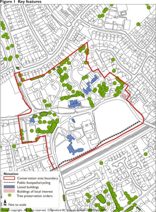
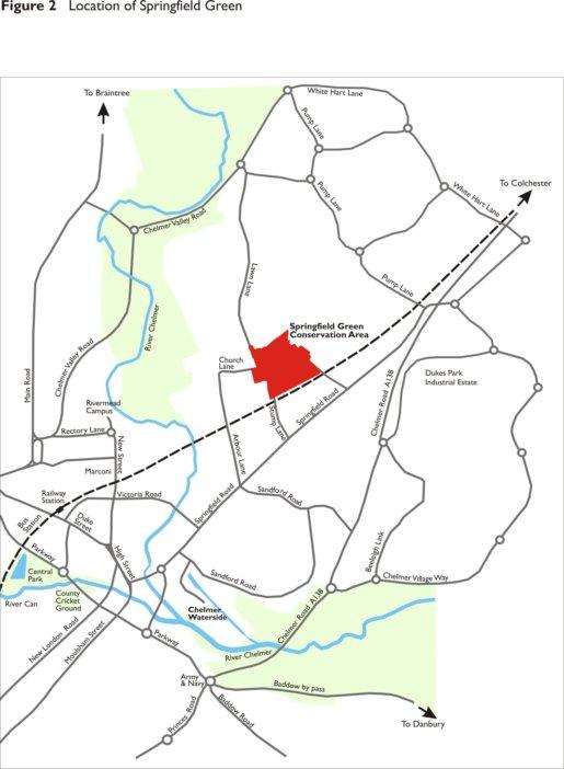
3 2.0 Statutory Protection (Figure 1) The conservation area was designated by Chelmsford Borough Council on the 7 th September 1982 (figure 1). There are six listed buildings within the area. These are All Saints Church and The Old Rectory, both grade II*, Dukes Priory, Springfield Dukes Cottages, Springfield Place and Springfield Place Coach House, all grade II. There is a cycle way and public footpath which runs along the southern boundary of the conservation area and follows the railway line towards Chelmsford town centre. There are Tree Preservation Orders (TPO s) covering trees at the Old Rectory (TPO/86/036), Church Lane (TPO/80/002, TPO/82/0117, TPO/71/002), Lawn Lane (TPO/85/043, TPO/01/077), Springfield Place (TPO/82/0117, PO/71/002) and Springfield Green (TPO/85/034). In addition, any other tree within the conservation area is protected by the requirement to give written notification of proposed works to a tree in a conservation area to the local planning authority at least six weeks before it is intended to carry out those works. 3.0 Location and Setting Springfield Green is located within the urban area of Chelmsford, approximately 1.4km northeast of the town centre (figure 2). The London to Norwich railway line is immediately to the south. To the north and east there is 1970s estate housing. The main approaches are from Springfield Road, either from the south along Stump Lane, the southeast along Springfield Green or the west via Arbour Lane. Lawn Lane provides a north-south route linking with the Chelmer Valley Way, Broomfield and Little Waltham. The site is on the edge of the valley where the rivers Chelmer and Wid meet in Chelmsford town centre, with the north Essex boulder clay plateau beyond. 4.0 Origins and Development There is archaeological evidence of human habitation in the wider area from the prehistoric period, when the fertile valleys of the rivers Chelmer and Wid provided a scene for hunter gatherers. Two significant Neolithic (c.4,000 BC) sites have been found in the vicinity of Chelmsford, thought to be part of a sophisticated social and economic system operating in the Chelmer Valley and Blackwater Estuary. Springfield Cursus, a kind of processional way with a large ditch and internal bank, was located close to the flood plain. A causewayed enclosure has also been found at Springfield Lyons. A Bronze Age (c.2,000 BC) ring ditch enclosure was later constructed at Springfield Lyons. A Roman settlement existed nearby at Moulsham. Springfield Road is itself the London-Colchester Roman Road. The re-use of Roman brick in the construction of All Saints Church suggests there may have been Roman buildings in the vicinity of Springfield Green. The first firm evidence of buildings at Springfield Green is the extant All Saints Church originating from the early twelfth century. A map by John Walker of c.1615 shows buildings on the sites of the present Springfield Place and Dukes, for the latter a mansion house is recorded on the site in 1361.
4
5
.")
6 It is likely the church was built to serve a dispersed agricultural community and the historic core of the parish developed around it. During the eighteenth century The Old Rectory, Springfield Place and Dukes were constructed. These three buildings are identified on the Chapman and Andre map of 1777 (figure 3). The four main routes to the green, Arbour Lane, Lawn Lane, Stump Lane and Springfield Green, also exist at this time. A number of other buildings are also shown around the green and at the junction with Springfield Road. A formal landscape is indicated to the north of Springfield Place. The pre-railway settlement is further shown in the tithe map of 1842 (figure 4). This clearly shows the layout of the key historic buildings which remain today and indicates a pattern of early field boundaries to the surrounding area. The first edition ordnance survey map of 1878 (figure 5) shows the railway line (completed in 1843) and depicts the area in great detail, including a parkland setting to the north of Springfield Place and ponds on the edge of the green, adjacent to Dukes and at the Rectory. Figure 3 Chapman and Andre map 1777


7 The parish boundary was redrawn in the nineteenth century, so that Springfield Green forms part of the Chelmsford urban area and the parish of Springfield therefore no longer has a physical historic core within its boundaries. By1942 (Figure 6) there is little change, although ribbon development along Springfield Road is apparent. The modern day settlement is set within the urban expansion of Chelmsford, surrounded by estate housing, mostly dating from the 1970s. All Saints Church retains its strong links with the community. Figure 4 Tithe map 1842 Figure 5 First edition ordnance survey map 1878 Figure 6 Fourth edition ordnance survey map 1942


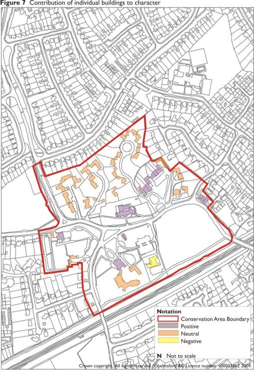
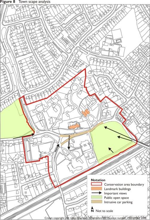
8 5.0 Character Appraisal The conservation area boundary is clearly defined to the south by the railway line. To the west the boundary includes the Old Rectory and Stump Lane, the front gardens of the houses on the west side of Stump Lane are also included as the open setting and trees contribute to the rural character of the lane. To the east the boundary follows the outside of the green and includes historic buildings at the corner of Exeter Road. To the north the boundary is defined by modern estate housing. The late twentieth century housing within the immediate setting of Springfield Place and the edge of Lawn Lane is included because of its open, low density layout, and its historic association with Springfield Place and its trees all contribute to local character. The area substantially retains its village green character, focused on All Saints Church and large houses set in substantial grounds, surrounded by mature trees and open spaces, including the green itself. The contribution of individual buildings and townscape analysis plans are shown as figures 7 and 8. Contribution to character is based on English Heritage assessment criteria, as set out in Appendix A. 5.1 Spatial Analysis The green is a significant open space at the centre of the area. To the south the cycle/footpath provides an important link with the town centre. The railway line within a deep cutting is barely visually discernable, although the industrial style galvanised boundary fence stands out as an incongruous feature. On the approach from Springfield Road the hump back bridge over the railway line frames a view towards the green, with Springfield Place as the main focus and All Saints Church beyond (figure 9). The clump of trees to the eastern edge of the green helps to define its edge and focus views. Dense planting encloses the green on the north and east sides, framing views of Springfield Place (figure 10). The former route of the track toward All Saints Church remains as an indentation running across the green. The semi detached almshouses (figure 11) are included within the conservation area and are also of local interest. They were designed by J. Clarke, are constructed of red brick and flint, with decorative timber gables. The inscribed tie beams read These almshouses were erected 1878 and In memoriam M S Orbit An unsympathetic flat roofed extension has been added to number 40 (the right hand side), however they remain an important feature on the edge of the green. Number 42, a red brick late nineteenth century house, is also included within the conservation area due to its historic character and group value with the almshouses. Figure 9 Figure 10 Figure 11
9
10
 Springfield Green are late twentieth century houses, but have an informal layout, open setting and extensive mature treed gardens (figure 12) and form part of the conservation")
.")


11 The modern estate housing adjacent to Exeter Road is beyond the conservation area. Number (even) Springfield Green are late twentieth century houses, but have an informal layout, open setting and extensive mature treed gardens (figure 12) and form part of the conservation area s character. The grass verge to the front of 2 and 4 Exeter Road is included within the conservation area as a part of the open setting to the green. From Exeter Road the mature trees to the former grounds of Springfield Place and on the green are a significant feature (figure 13). Figure 12 Springfield Place is one of three exceptionally fine red brick eighteenth century houses within the area. It dates from early in the century and has a nine bay front with two projecting wings incorporating diocletion windows to the top floor. Substantial elements of the walled garden to the rear and boundary treatments to the front remain, which contribute to its setting and status. From within the grounds to the front of Springfield Place there is a strong visual relationship with All Saints Church. Views south across the green are enclosed by mature tree planting. Figure 13 The house and coach house were each converted into three houses in 1982 and further development followed to the north. Despite this the appearance from the green remains as a fine mansion in open grounds. The coach house is set back from the green, but from within the grounds has a strong visual relationship with Springfield Place (figure 14). The housing to the north is informally laid out, of modest scale, within a landscape setting and with significant tree planting. Figure 14 All Saints Church (figure 15) is the most significant building within the area and is the focus of views on approaching from all directions, although its modest height, enclosed surrounding (both built and treed) and topography mean that it is not visible in any long views from the surrounding area. The churchyard provides a tranquil setting at the centre of the area, with many mature fine trees to its perimeter. Figure 15


.")
12 The church itself originates from the early twelfth century, the flint rubble nave includes a round headed Norman window formed with a Roman brick surround. The chancel and tower were added in the early fourteenth century, following collapse the tower was partly rebuilt using red brick, which is dated to 1586 by the inscription in the south elevation. The whole church was restored in 1867 by J. Clarke, who added the south porch. During the restoration a number of monuments were moved to the base of the tower, including that of Richard Coates, the engineer to the Chelmer and Blackwater Navigation who died in1822. A stair turret was added to the northwest side of the tower by Frederick Chancellor in 1887, who also extended the vestry. There is a large brick meeting room to the north added in 1979 and further extended in To the southwest of All Saints the small triangular green has a massive mature London Plane (figure 16). The green is simply defined by timber posts. Parking is visually intrusive around the green and to this part of Church Lane. To the west the low density bungalows are unobtrusive and include many significant trees and hedges. The entrance and boundary treatments are important aspects of the understated appearance of the building group. Further west, Lawn Lane is significant for its tree lined approach to the area, with gardens to the east and Pollards Meadow recreation ground to the west. At the junction of Lawn Lane and Church Lane The Old Rectory is a key feature (figure 17). The grounds include many fine trees and provide an important open setting to the house. To the west is a long linear pond, a miniature version of the grand canal at Boreham House, probably dug when the Old Rectory was built. The building itself is a fine mid eighteenth century house, dated by a lead hopper head to the north front, containing the date 1752 and the initials CG, for Charles Grettan (inducted 1746). The roof has two ranges, with dormers and two gables on the north front facing Lawn Lane. The boundary to Lawn Lane has a high red brick eighteenth century wall, beyond which there is a close boarded fence to the corner of Stump Lane, which appears incongruous. Opposite, Springfield Dukes (now the Priory Hospital) is an early eighteenth century mansion sitting within substantial well treed grounds. The east front has seven bays with blue bricks and red brick window surrounds and a central segmental pediment (figure 18). To the rear the building was considerably remodelled by Arthur Needham Wilson c.1906 in the Arts and Crafts style with plain tile hanging and casement windows. Beyond are further late twentieth century hospital buildings, which although of considerable size, manage to preserve the important open setting to the group. Figure 16 Figure 17 Figure 18


13 To the east, there is a large pond, then extensive areas of surface parking, which although intrusive within the site, are screened from public view. The flat roofed 1960s clinic building to the southeast corner of the site is bland and detracts from the character of the area. On the northern boundary Springfield Dukes Cottages (figure 19) are modest eighteenth century timber framed buildings, which are prominent from Church Lane. Oliver Goldsmith is reputed to have lived in one of the cottages and written his poem The Deserted Village there. Figure 19 Stump Lane opens out at its junction with Church Lane and provides a fine view of All Saints Church, little changed since the early twentieth century (figure 20). To the south the well treed grounds to Springfield Dukes flank the lane to the east with houses to the west. The spacing of the houses, open front gardens and hedges and trees helps to provide a soft edge and add to the rural character of the lane (figure 21), although recent garage blocks, hard standings and boundary treatments give an overly suburban appearance. Figure 20 Figure 21 The railway embankment is well screened by mature trees on both sides. The footpath/cycleway adjacent to the railway line provides a route back to the green. This path is enclosed by trees and hedges and meanders lightly, giving visual interest (figure 22). At the eastern end the unattractive clinic building is glimpsed, then on reaching the green, views open up across the green and towards Springfield Place. Figure 22

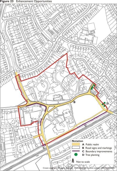
14 6.0 Management Proposals 6.1 Street Furniture At present there is a mixture of street furniture, including traditional street lamps to the cycle/footpath and other utilitarian units elsewhere throughout the public realm (figure 23, A). A co-ordinated range of high quality street furniture, including street lighting, bins, benches, signs etc. in a traditional or contemporary style would enhance the public realm of the area. 6.2 Road Markings and Signs Church Lane suffers from considerable visual intrusion by parked cars and highways markings. As part of any proposals to address these issues, visually intrusive signs should be avoided in the most sensitive areas to the front of All Saints Church and Springfield Place (figure 23, B). Any road markings should be the minimum required and yellow lines in the narrow primrose format. Signs should be of minimum size and carefully positioned, where possible using existing walls, posts or lampposts, or where necessary on new black posts. 6.3 Boundary Treatments. Boundary treatments can have a significant impact on the character of the area, both positive and negative. Important brick boundary walls survive at the Old Rectory, All Saints Church and Springfield Place, including elements of the former walled garden to the northeast. In the past, unsympathetic repairs have been carried out to the walls using poorly matching materials and hard cement based mortar. The walls were built in lime mortar which is more flexible, compatible with the soft red bricks and visually attractive. Historic boundary walls should be retained and where necessary repaired using matching traditional materials. The fence which follows the railway line between Springfield Green Bridge and the enclosed footway (figure 24) to the south of Springfield Dukes, and at the edge of Stump Lane (figure 23, C), is a utilitarian structure which is visually intrusive on the edge of the green. Replacement or painting the existing fence would enhance this area. There are a few areas where inappropriate boundary treatments, such as close boarded fences or overly ornate railings detract from the village character of the area (figure 23, C). Where the opportunity arises boundary treatments appropriate to their context should be provided, which depending on their location should range from a selection of native hedges, bricks walls or simple railings. 6.4 Tree Planting and Management Figure 24 There are trees within the conservation area which make a significant contribution to the character of the area and are also beneficial for screening and biodiversity. In order to ensure continuity of tree planting, a tree management plan could be prepared and a phased scheme of replacement planting and management of existing trees prepared.
15
16 There are a few areas where additional tree planting could be used to reinforce the character of the area. Possible locations are identified on figure 23, D. Bibliography Historic Environment Characterisation, Essex County Council, Guidance on Conservation Area Appraisals, English Heritage, Buildings of England: Essex. Bettley, J and Pevsner, N. 1999
helmsford Broomfield Conservation Area Borough Heritage Conservation area Character Appraisal Status: Consultation Draft
 Borough Heritage Conservation area Character Appraisal Broomfield Conservation Area Status: Consultation Draft Design and conservation 01245 606294 michael.hurst@chelmsford.gov.uk helmsford BOROUGH COUNCIL
Character Area 1: Town Core
 Character Area 1: Town Core Map S 354 Copyright Cotswold District Council 109 Character Area 1: Town Core Key Characteristics 355 356 357 358 359 360 361 362 363 364 365 366 367 368 369 370 Copyright Cotswold
STRENSALL RAILWAY BUILDINGS CONSERVATION AREA APPRAISAL. In association with Strensall with Towthorpe Parish Council
 STRENSALL RAILWAY BUILDINGS CONSERVATION AREA APPRAISAL In association with Strensall with Towthorpe Parish Council CONTENTS Page 1 Introduction 2 2 Location and Context 3 3 Topography and Setting 4 4
ENVIRONMENTAL AND LANDSCAPE MAPPING
 APPENDIX IV : Environmental and Landscape Mapping ENVIRONMENTAL AND LANDSCAPE MAPPING Calveley Neighbourhood Plan November 2016 ENVIRONMENTAL AND LANDSCAPE MAPPING Calveley Neighbourhood Plan Calveley
Appraisal of proposed alterations to the boundary of Helmsley Conservation Area
 Appraisal of proposed alterations to the boundary of Helmsley Conservation Area Elmslac Road: Elmslac Road was constructed in the early 1950s in two or three stages by the Helmsley Rural District Council.
Lancaster Conservation Area Appraisal. Character Area 8. Cathedral
 Lancaster Conservation Area Appraisal Character Area 8. Cathedral March 2013 118 3.8 Character Area 8. Cathedral 3.8.1. Definition of Special Interest "This character area is distinctive for the fine group
Environmental and Landscape Mapping
 Environmental and Landscape Mapping In support of the Calveley Neighbourhood Plan November 2016 Project Name and Number: Calveley Neighbourhood Plan 16-025 Document Name and Revision: Environmental and
7.1 Area 1: Haslemere Conservation Area
 7.1 Area 1: Haslemere Conservation Area Detailed map of Haslemere Town Conservation Area as of 2006 Crown copyright and database right 2011 Ordnance Survey LA100025451 27 The Conservation Area is characterised
Conservation Area Designation, amendments and Review
 Conservation Area Designation, amendments and Review Location: No.s 37-49 (odd) Twickenham Road Date Assessed: January 2018 Adjacent Conservation Area Significance: Teddington Lock CA. The Teddington Lock
DRAFT CONSERVATION AREA APPRAISAL CHAILEY GREEN DESIGNATED
 DRAFT CONSERVATION AREA APPRAISAL CHAILEY GREEN DESIGNATED 16.06.76 DRAFT CHAILEY GREEN CONSERVATION AREA APPRAISAL 1 SUMMARY 1.1 Key Positive Characteristics 1.2 Recommendations 2 INTRODUCTION 2.1 The
BROADHEMBURY DESIGN STATEMENT
 BROADHEMBURY DESIGN STATEMENT As drawn up by Broadhembury Parish Council during the development of a Parish Plan and adopted at its meeting on 17 th May 2010 BROADHEMBURY DESIGN STATEMENT Contents Introduction
DACORUM GOLDEN PARSONAGE Great Gaddesden Brief Description Principal Building: Approach: Stable block other utilitarian buildings: Walled Garden:
 HERTFORDSHIRE GARDENS TRUST LOCAL LIST: DACORUM Present Name of Site GOLDEN PARSONAGE Historic Name (if known) Parish/Town Great Gaddesden National Grid Reference of Principal Building: TL051 125 Present
UPPER GORDON ROAD TO CHURCH HILL, CAMBERLEY CONSERVATION AREA
 Introduction This leaflet explains the purpose of conservation areas and the implication of their designation for residents, property owners and the Council. It provides you with a plan of the area and
STATEMENT OF OBJECTION TO THE PROPOSED DEVELOPMENT OF LAND AT CHURCH CLIFF DRIVE FILEY
 STATEMENT OF OBJECTION TO THE PROPOSED DEVELOPMENT OF LAND AT CHURCH CLIFF DRIVE FILEY You will be aware that Scarborough borough council have adopted a new local plan that includes land at Church Cliff
Case Studies; Meitheal Clusters Applied to Villages and Rural Settlements
 Case Studies; Meitheal Clusters Applied to Villages and Rural Settlements 23.3.9 (ii) Case Studies, Meitheal Clusters applied to villages and rural settlments Fig 22.3.12 Cluster site plan; church opposite
Friends Meeting House, Broughton. Meeting House Lane, Little Broughton, Cockermouth, CA13 0YQ. National Grid Reference: NY
 Friends Meeting House, Broughton Meeting House Lane, Little Broughton, Cockermouth, CA13 0YQ National Grid Reference: NY 07832 31740 Statement of Significance The modest building has medium significance
Conservation Area Designation, amendments and Review
 Conservation Area Designation, amendments and Review Location: Any area largely confined to Park Road and St. James Avenue which includes the following properties: St. James Church, St. James Road; No.
MATURE SUBURBS RESIDENTIAL DEVELOPMENT GUIDELINES
 MATURE SUBURBS RESIDENTIAL DEVELOPMENT GUIDELINES DRAFT FEBRUARY 2005 BIRMINGHAM CITY COUNCIL 1 Introduction Mature Suburbs Residential Development Guidelines - Interim Supplementary Planning Advice -
WANSFORD. Village Design Statement. Supplementary Planning Guidance adopted by Peterborough City Council on 22 nd August 2003
 WANSFORD Village Design Statement 2003 Supplementary Planning Guidance adopted by Peterborough City Council on 22 nd August 2003 Prospect of Wansford Bridge, St. Mary s Church and Bridge End, c.1902 Conceived,
INTRODUCTION CURRENT APPLICATION
 05/01805/FUL & 05/01807/LBC ERECTION OF A SINGLE DWELLING HOUSE WITH ANCILLARY ACCOMMODATION AT Flamingo Zoological Gardens, Olney Road, Weston Underwood FOR Mr A J Crowther (as amended by letter dated
HERITAGE COUNTS 2017 East of England
 HERITAGE COUNTS 2017 East of England Introduction Heritage Counts 2017 is the sixteenth annual survey of the state of England s historic environment. This Regional Report is prepared by Historic England
Introduction. Welcome to this consultation regarding the draft redevelopment proposals for the former CeramTec factory on Sidmouth Road, Colyton.
 Introduction Welcome to this consultation regarding the draft redevelopment proposals for the former CeramTec factory on Sidmouth Road, Colyton. We are currently considering options for the mixed-use redevelopment
Welcome. Land adjacent Sandy Lane WALTHAM CHASE THE PROPOSED SITE
 Land adjacent Sandy Lane WALTHAM CHASE Existing Linden Homes developments Welcome Welcome to Linden Homes Southern s ( Linden ) public exhibition about its proposals for a range of high-quality homes for
DESIGN & ACCESS STATEMENT
 . DESIGN & ACCESS STATEMENT Site Adjacent to The Manor House, Upper Street,, Kingsdown, Deal, Kent. DESIGNS ARCHITECTURE + PLANNING CONTENTS Design and Access Statement Introduction Site and Location Planning
Status of Supplementary Planning Guidance OLD WOKING CONSERVATION AREA Character Appraisal and design Guidance
 Status of Supplementary Planning Guidance OLD WOKING CONSERVATION AREA Character Appraisal and design Guidance Status This Planning Guidance which is supplementary to Policy BE9 of the Woking Borough Local
HERITAGE STATEMENT AND IMPACT ASSESSMENT HILLBARK FARMHOUSE FRANKBY
 HILLBARK FARMHOUSE HERITAGE STATEMENT AND IMPACT ASSESSMENT HILLBARK FARMHOUSE FRONT ENTRANCE CONTENTS Executive summary 1.0 INTRODUCTION 1.1. Background to the report 1.2. Purpose of the Report 2.0 SIGNIFICANCE
Lincoln Townscape Assessment. Boultham Park Inherited Character Area Statement
 Lincoln Townscape Assessment Boultham Park Inherited Character Area Statement January 2008 Page 2 of 12 Table of Contents Page Overview 2 Historical Development 2 Urban form 3 Views 5 Condition of Buildings
Derry City and Strabane District Council Planning Committee Report
 Derry City and Strabane District Council Planning Committee Report COMMITTEE DATE: 23 rd March 2016 APPLICATION No: APPLICATION TYPE: PROPOSAL: LOCATION: APPLICANT: LA11/2015/0395/F Residential Development
Public Consultation. Land at Monks Farm, North Grove. Welcome
 Welcome Welcome to our public exhibition for development on Land at Monks Farm, orth Grove. Gallagher Estates and Gleeson Strategic Land are preparing an outline planning application for new homes, open
National Character Area 70 Melbourne Parklands
 Summary The are a landscape of rolling farmland, parkland and woodland on the northern flanks of the ridge between Burton upon Trent and Swadlincote. The land slopes down to the River Trent, which borders
March General enquiries: Web site:
 REDEVELOPMENT OF WILSON HOSPITAL FOR MITCHAM LOCAL CARE CENTRE Community Planning & Design Brief for Merton Clinical Commissioning Group and London Borough of Merton March 2016 1. Mitcham Cricket Green
PLANNING COMMITTEE DATE: 07/09/2015 REPORT OF THE SENIOR MANAGER PLANNING AND ENVIRONMENT SERVICE CAERNARFON. Number: 4
 Number: 4 Application Number: C15/0034/37/LL Date Registered: 21/05/2015 Application Type: Full - Planning Community: Llanaelhaearn Ward: Llanaelhaearn Proposal: Location: Summary of the Recommendation:
Garage Site, Foots Cray High Street, Sidcup, Kent, London Borough of Bexley
 Garage Site, Foots Cray High Street, Sidcup, Kent, London Borough of Bexley An Archaeological Evaluation for Mizen Design Build by Andy Taylor Thames Valley Archaeological Services Ltd FOC 07 September
ENVIRONMENTAL INVENTORY
 Hungarton Neighbourhood Plan ENVIRONMENTAL INVENTORY Sites scoring 25/36 or more (70%) are judged to be the most important environmental and community sites and are proposed as Local Green Space. Other
SOUTH CAMBRIDGESHIRE DISTRICT COUNCIL. Executive Director (Operational Services) Corporate Manager (Planning and New Communities)
 Corporate Manager (Planning and New Communities)") SOUTH CAMBRIDGESHIRE DISTRICT COUNCIL REPORT TO: Planning Committee 12 January 2011 AUTHOR/S: Executive Director (Operational Services) Corporate Manager (Planning and New Communities) Notes: S/1848/10
SOUTH CAMBRIDGESHIRE DISTRICT COUNCIL REPORT TO: Planning Committee 12 January 2011 AUTHOR/S: Executive Director (Operational Services) Corporate Manager (Planning and New Communities) Notes: S/1848/10
Archaeological evaluation at Willowdene, Chelmsford Road, Felsted, Essex
 Archaeological evaluation at Willowdene, Chelmsford Road, Felsted, Essex August 2013 report prepared by Ben Holloway on behalf of Mr Anthony McGurren Planning reference: UTT/13/0235 CAT project ref.: 13/07g
Streets for All East of England
 Streets for All East of England Summary In 2017 Historic England published an updated national edition of Streets for All, a practical guide for anyone involved in planning and implementing highways and
Historic England Advice Report 26 August 2016
 Case Name: Kingsland Castle Case Number: 1435892 Background Historic England has been asked to review the scheduling for Kingsland Castle. The land on which the monument lies is understood to be for sale.
CLOUGHJORDAN SETTLEMENT PLAN
 CLOUGHJORDAN SETTLEMENT PLAN 1.0 General Introduction and Development Context Location The market town of Cloughjordan lies close to the border with Offaly at the junction of the R490 and R491 Regional
13. London Bridge London Bridge Area Vision
 13. 13.1. Area Vision 13.1.1. is: A globally significant central London business district which is home to international business headquarters; Internationally renowned for its prominent riverfront location
97 Lea Bridge Road, Leyton, E10 7QL London Borough of Waltham Forest December 2015
 97 Lea Bridge Road, Leyton, E10 7QL London Borough of Waltham Forest December 2015 Public Realm and Landscape Proposals LEA BRIDGE ROAD, WALTHAMSTOW Public Realm & Landscape Proposals BDP(90)RPT001 December
CALA HO ME S WELCOME
 WELCOME Welcome to this public consultation event for our proposed residential development of 56 high quality homes on land to the north east of Station Road in Earls Colne. Thank you for taking the time
Design and Access Statement. Redevelopment of Marcris House, Coopersale Lane, Theydon Boise to provide 11 new apartments.
 Design and Access Statement for Redevelopment of Marcris House, Coopersale Lane, Theydon Boise to provide 11 new apartments Prepared by ISL Architecture For Chigwell Homes Ltd dated October 2015 1 Introduction
1 The development hereby permitted shall be carried out in accordance with the following approved plans:
 Location 59 Greenway Close London N20 8ES Reference: 16/00011/HSE Received: 30th December 2015 Accepted: 7th January 2016 Ward: Totteridge Expiry 3rd March 2016 Applicant: Mr Ankit Shah Proposal: Part
The eight-week period for this application expires on 5 October 2006.
 06/01213/FUL CHANGE OF USE FROM AGRICULTURAL LAND TO PRIVATE CAR PARK AND NEW FENCING. AT Land To The South of Perceval Almhouses, Lower Weald, Calverton FOR Calverton Parochial Church Council INTRODUCTION
Site ref: AS06 Site Name or Address: Murreys Court, Agates Lane
 Site ref: AS06 Site Name or Address: Murreys Court, Agates Lane Proposed Land Use: Total Site Area (Ha): Housing 1.85 Ha Description: It is understood that the owner has no plans to dispose of the site
LETTER OF OBJECTION LAND TO THE SOUTH WEST OF FORGE GARAGE, HIGH STREET, PENSHURST, KENT, TN11 8BU
 Senior Planning Officer Andrew Byrne Sevenoaks District Council Community & Planning Services PO Box 183 Argyle Road Sevenoaks Kent TN13 1GN 04 November 2011 Your Ref: 11/02258/FUL For the attention of
Name: Former Ornamental Garden and Trees at 1 Harestone Drive. Site is Grounds of 1 Harestone Drive formerly the Marie Curie Hospice.
 Name: Former Ornamental Garden and Trees at 1 Harestone Drive Location: Site is Grounds of 1 Harestone Drive formerly the Marie Curie Hospice. No.48 Coloured Red on plan. Description. Former site of Harestone
Viewpoint 1. Location: View from Murch Road on the north eastern boundary of Application Site. Viewing south / southwest.
 Application Site (eastern field) Former site of St. Cyres Lower School Murch Road 1 Location: View from Murch Road on the north eastern boundary of Application Site. Viewing south / southwest. Baseline
3 Abbey View Mill Hill London NW7 4PB
 Location 3 Abbey View Mill Hill London NW7 4PB Reference: 15/03203/HSE Received: 26th May 2015 Accepted: 16th June 2015 Ward: Mill Hill Expiry 11th August 2015 Applicant: Proposal: Mr Richard Benson Alterations
ABOUT CALA HOMES CALA HOMES
 WELCOME Welcome to this public consultation event for our proposed development on land to the east of Salisbury Road, in Hungerford. Thank you for taking the time to come along today. Homes and Wates Developments
8. Camberwell 8.1. Camberwell Area Vision
 8. 8.1. Area Vision 8.1.1. is: Centred on a medieval village centre which has become a thriving modern town centre surrounded by residential streets laid out in the Georgian era; Linked by rail to central
MID SUFFOLK DISTRICT COUNCIL DEVELOPMENT CONTROL COMMITTEE A - 09 November (1) The application site is owned by Mid Suffolk District Council.
 The application site is owned by Mid Suffolk District Council.") MID SUFFOLK DISTRICT COUNCIL DEVELOPMENT CONTROL COMMITTEE A - 09 November 2016 I AGENDA ITEM NO APPLICATION NO PROPOSAL SITE LOCATION SITE AREA (Ha) APPLICANT RECEIVED EXPIRY DATE 1 2776/16 Erection of
MID SUFFOLK DISTRICT COUNCIL DEVELOPMENT CONTROL COMMITTEE A - 09 November 2016 I AGENDA ITEM NO APPLICATION NO PROPOSAL SITE LOCATION SITE AREA (Ha) APPLICANT RECEIVED EXPIRY DATE 1 2776/16 Erection of
NAA SITE REF: HG2-22 CHURCH STREET, BOSTON SPA LEEDS LDF SITE ALLOCATIONS PLAN PRE-SUBMISSION CHANGES (FEBRUARY 2017) HERITAGE REPRESENTATIONS
 HERITAGE REPRESENTATIONS") NAA LEEDS LDF SITE ALLOCATIONS PLAN PRE-SUBMISSION CHANGES (FEBRUARY 2017) HERITAGE REPRESENTATIONS Northern Archaeological Associates Ltd. Marwood House Harmire Enterprise Park Barnard Castle Co. Durham
NAA LEEDS LDF SITE ALLOCATIONS PLAN PRE-SUBMISSION CHANGES (FEBRUARY 2017) HERITAGE REPRESENTATIONS Northern Archaeological Associates Ltd. Marwood House Harmire Enterprise Park Barnard Castle Co. Durham
Examination of South Cambridgeshire Local Plan
 Matter SC6A - Policy SS/5 Waterbeach New Town Historic England( formerly English Heritage) 874 Rep Nos 59748, 60250, 60253 Examination of South Cambridgeshire Local Plan Historic England, Hearing Statement
APP/G1630/W/15/
 Appeal Decision Site visit made on 20 October 2015 by William Fieldhouse BA (Hons) MA MRTPI an Inspector appointed by the Secretary of State for Communities and Local Government Decision date: 20 November
PDP DESIGN & ACCESS STATEMENT
 PDP The Planning & Design Partnership Planning.. Architecture.. Interiors.. Landscape The Chicory Barn Studio, The Old Brickyards, Moor Lane, Stamford Bridge York, The East Riding Of Yorkshire, YO41 1HU.
10. East Dulwich East Dulwich Area Vision
 10. 10.1. Area Vision 10.1.1. is: A predominantly residential area characterised by mostly medium density housing, including many family homes. Many parts of have retained historic character and it includes
Land Adj. 63 Sunny Bank Road, Sutton Coldfield, Birmingham, B73 5RJ
 Committee Date: 11/07/2013 Application Number: 2013/03520/PA Accepted: 20/05/2013 Application Type: Full Planning Target Date: 15/07/2013 Ward: Sutton Vesey Land Adj. 63 Sunny Bank Road, Sutton Coldfield,
Welcome to our Public Consultation
 About our development This exhibition gives you the chance to view and comment on our emerging plans for a proposed residential development located on land to the West of Alwyn Road, Rugby. Welcome to
SETTLEMENT ASSESSMENT PROFORMA
 SETTLEMENT ASSESSMENT PROFORMA Surveyors(s):Clare Sheridan Character Area: Park Estate = Midland Rd, Severn Rd, Festival Rd, Park Rd, Willow Rd, Rylands Rd. Date: Feb Weather: cloudy Look through all the
Neighbourhood Plan Representation
 Date: 10 th November 2017 Neighbourhood Plan Representation Land to the east of Callow Hill Road, Alvechurch Introduction This representation has been prepared by RPS Planning and Development on behalf
Alresford Grange. a l r e s f o r d n c o lc h e s t e r n e s s e x
 Alresford Grange a l r e s f o r d n c o lc h e s t e r n e s s e x 1 2 Alresford Grange a l r e s f o r d n c o l c h e s t e r n e s s e x Superbly positioned Edwardian country house with exceptional
Tazewell Pike. Neighborhood Conservation Overlay District Design Guidelines
 Tazewell Pike Neighborhood Conservation Overlay District Design Guidelines Knoxville Knox County Metropolitan Planning Commission November 2, 2000 These design guidelines were: Adopted by the Knoxville
Cottage Grove. Conservation Area. Character Appraisal
 Positive People - Positive Leadership - Positive Partnerships Cottage Grove Conservation Area Character Appraisal Consideration of Proposal to Designate Grove Avenue and Park Road Chilwell as a Conservation
5 Gratton Terrace London NW2 6QE. Reference: 17/5094/HSE Received: 4th August 2017 Accepted: 7th August 2017 Ward: Childs Hill Expiry 2nd October 2017
 Location 5 Gratton Terrace London NW2 6QE Reference: 17/5094/HSE Received: 4th August 2017 Accepted: 7th August 2017 Ward: Childs Hill Expiry 2nd October 2017 Applicant: WSD (Gratton) Ltd Proposal: The
East Harptree Landscape & Character Assessment
 East Harptree Landscape & Character Assessment Produced by East Harptree Parish Council in consultation with local residents September 2014 Contents The Parish of East Harptree: Objective Introduction
Replacement Golf Course Facilities and Residential Development, Churston. Environmental Statement Non-Technical Summary
 Replacement Golf Course Facilities and Residential Development, Churston Environmental Statement Non-Technical Summary July 2011 Reproduced from the Ordnance Survey s map with the permission of the Controller
SOUTH CAMBRIDGESHIRE DISTRICT COUNCIL. Planning and New Communities Director
 SOUTH CAMBRIDGESHIRE DISTRICT COUNCIL REPORT TO: Planning Committee 5 June 2013 AUTHOR/S: Planning and New Communities Director S/0747/13/FL HISTON Construction of Car Park at Histon Baptist Church, Station
Appendix 4 - Character Assessment and Design Code. Character Assessment
 Appendix 4 - Character Assessment and Design Code Character Assessment To gain a deeper understanding of the Parish for the Neighbourhood Plan, a Character Assessment of the parish was carried out with
Derry City and Strabane District Council Planning Committee Report. Amended layout from approval A/2004/0462/F with reduction from 166 units
 Derry City and Strabane District Council Planning Committee Report COMMITTEE DATE: 1 st February 2017 APPLICATION No: APPLICATION TYPE: PROPOSAL: LOCATION: APPLICANT: AGENT: Full Planning application Amended
Appendix B Figures L1 and L2 - Townscape Analysis
 The Derriford Transport Scheme WEBTag Townscape and Visual Impact Appraisal (WTVA) Appendix B Figures L1 and L2 - Townscape Analysis J:\29210 Plymouth City Modelling\Technical\Landscape\Reports\29210_De
Colchester Northern Gateway Master Plan Vision Review Draft. July 2016
 Colchester Northern Gateway Master Plan Vision Review Draft July 2016 Contents Introduction 4 Context 8 Purpose of the Report 8 Strategic Position 9 Overview of the Process 11 2012 Master Plan Vision 12
7.2.9 Eudlo local plan code
 7.2.9 local plan code 7.2.9.1 Application (1) This code applies to assessable development:- (a) within the local plan area as shown on Map ZM29 contained within Schedule 2 (Mapping); and (b) identified
Ward: West Wittering. Proposal Change of use from public highway pavement to residential garden use.
 Parish: West Wittering Ward: West Wittering WW/17/03295/FUL Proposal Change of use from public highway pavement to residential garden use. Site Izora 1 Watersedge Gardens West Wittering PO20 8RA Map Ref
Lincoln Townscape Assessment. Sherbrooke Inherited Character Area Statement
 Lincoln Townscape Assessment Sherbrooke Inherited Character Area Statement June 2008 Page 2 of 15 Table of Contents Page Overview 2 Historical Development 3 Urban form 4 Views 8 Condition of Buildings
Historical Value As evidence of Quaker heritage in Wells extending over three hundred years, the meeting house has high historical value.
 Friends Meeting House, Wells-next-the-Sea Quaker Yard, Church Street, Wells-next-the-Sea, Norfolk, NR23 1HZ National Grid Reference: TF 91978 43092 Statement of Significance The building has high significance
DRAFT/02. Our Place. Westbury-on-Trym. City Design Group. July 2013 City Design Group
 DRAFT/02 City Design Group Contents Preface 1. Introduction 2. Character and distinctiveness 3. Character Areas 1 Henbury Road environs 2 Commercial core 3 College and Church Road environs 4 Channell
DESIGN & ACCESS STATEMENT
 DESIGN & ACCESS STATEMENT Land to the South East of the A495, Bronington Erection of 31 Dwellings (27 dwellings and 4 bungalows including 4 Affordable Dwellings), Realignment and Improvements to A495 (including
Land to West of Bessel s Way, Blewbury. Contextual Analysis. fluid
 Land to West of Bessel s Way, Blewbury Contextual Analysis fluid Contents fluid - Overview - Growth pattern - Footpath & Road connections - Landscape Character - Amenities - Agriculture - Characteristic
HeritageCollectiveLLP
 Appendix C, Review of Archaeology and Cultural Heritage Assessment Introduction 1. This information (SEI) addresses the likely significant impacts of a six-turbine development in which T6 is removed from
3 Tretawn Gardens London NW7 4NP
 Location 3 Tretawn Gardens London NW7 4NP Reference: 16/7886/HSE Received: 12th December 2016 Accepted: 19th December 2016 Ward: Mill Hill Expiry 13th February 2017 Applicant: Proposal: Mr Murray Two storey
SOUTH CAMBRIDGESHIRE DISTRICT COUNCIL. Planning and New Communities Director
 SOUTH CAMBRIDGESHIRE DISTRICT COUNCIL REPORT TO: Planning Committee 9 January 2013 AUTHOR/S: Planning and New Communities Director S/2270/12/FL FEN DRAYTON 850m long flood defence embankment ranging in
Welcome to our public exhibition
 About our development Welcome to our public exhibition This public exhibition gives you the opportunity to view and comment on our proposals to create a new residential development on land adjacent to
Derry City and Strabane District Council Planning Committee Report
 Derry City and Strabane District Council Planning Committee Report COMMITTEE DATE: 29 th November 2017 APPLICATION No: APPLICATION TYPE: PROPOSAL: LOCATION: APPLICANT: AGENT: LA11/2016/0854/O Outline Shared
PART 2 SOUTH DOWNS NATIONAL PARK AUTHORITY SECTION 1 SCHEDULE OF APPLICATION RECOMMENDATIONS
 42 PART 2 SOUTH DOWNS NATIONAL PARK AUTHORITY PLANNING COMMITTEE REPORT OF THE SERVICE MANAGER PLANNING DEVELOPMENT Applications to be determined by the council on behalf of the South Downs National Park
Reference: 16/1234/HSE Received: 25th February 2016 Accepted: 2nd March 2016 Ward: High Barnet Expiry 27th April 2016
 Location 7 Sunset View Barnet EN5 4LB Reference: 16/1234/HSE Received: 25th February 2016 Accepted: 2nd March 2016 Ward: High Barnet Expiry 27th April 2016 Applicant: Proposal: Mr & Mrs Peter & Anny Woodhams
Design Guidelines. High Point Estates Design Guidelines April Gomberoff Bell Lyon Architects Group Inc.
 High Point Estates April 2006 Gomberoff Bell Lyon Architects Group Inc. 1 29 Contents Part One The Building Scheme Part Two Architectural Character and Siting Building Part One: The Building Scheme i 31
Persimmon Homes Thames Valley Date received: 2 nd April week date(major): 2 nd July 2014 Ward: Nascot
: 2 nd July 2014 Ward: Nascot") PART A Report of: DEVELOPMENT MANAGEMENT SECTION HEAD Date of Committee: 26 th June 2014 Site address: Rounton, 28, Nascot Wood Road Reference Number: 14/00497/REM Description of Development: Reserved
PART A Report of: DEVELOPMENT MANAGEMENT SECTION HEAD Date of Committee: 26 th June 2014 Site address: Rounton, 28, Nascot Wood Road Reference Number: 14/00497/REM Description of Development: Reserved
Appendix B. Naughton. conservation area appraisal
 Appendix B Naughton conservation area appraisal Introduction The conservation area in Naughton was originally designated by Babergh District Council in 1981. The Council has a duty to review its conservation
Archaeological evaluation at New Hall School, The Avenue, Boreham, Chelmsford, Essex, CM3 3HS
 Archaeological evaluation at New Hall School, The Avenue, Boreham, Chelmsford, Essex, CM3 3HS December 2016 by Laura Pooley with contributions by Stephen Benfield figures by Ben Holloway and Emma Holloway
LONGDEN VILLAGE DEVELOPMENT STATEMENT
 LONGDEN VILLAGE DEVELOPMENT STATEMENT 2017-2027 1 Longden Development Statement 2017-2027 15/01/18 1. Background 1.1 Longden Village Longden village is a very rural and traditional community first mentioned
Newton Conservation Area
 Newton Conservation Area Appraisal www.doncaster.gov.uk/planning Newton Conservation Area Appraisal Index Preface Part I Appraisal 1. Introduction 2. Location 3. Origins and development of the settlement
Character Area Summary 6: Canal Zone Stonehouse Town Character Assessment, Bridgend Works from Downton Road
 Character Area Summary 6: Canal Zone An open area, with residential and industrial areas, which has a rural character and a rich historic and natural environment strongly influenced by the Stroudwater
Conservation Area Designation, amendments and Review
 Conservation Area Designation, amendments and Review Location: Are area largely confined to Cowley Road and North Warpole Way and incorporating the following properties: No.s 2-120 (even) & 61 123 (odd)
31 South Mardy. Exploring Abergavenny
 31 South Mardy Exploring Abergavenny Cover: St Teilo s Road 2 south mardy EXPLORING ABERGAVENNY For several years the Abergavenny and District Civic Society has been studying the streets, spaces and buildings
Camberwell Camberwell Area Vision Map
 Area Vision Map NSP23 Burgess Park Edmund Street NSP29 NSP30 NSP31 New Road Benhill Road NSP27 NSP33 Green Brunswick Park NSP22 station NSP24 Peckham Road NSP26 St Giles Church Lucas Gardens NSP28 NSP25
Billington Parish Green Infrastructure Plan
 Billington Billington Parish Green Infrastructure Plan Methodology Following a presentation to the Annual Parish Meeting, The Greensand Trust was invited to attend the next Parish Council Meeting. The
Stanton Drew Parish Neighbourhood Plan Landscape and Environment
 Contents Introduction... 2 Scope of the Document... 2 Our Definition of a View... 2 Proposed Policies... 3 Criteria for a Protected View... 3 Views Assessed... 4 View 1: from cricket ground north towards
List of Buildings of Local Architectural or Historic Interest BUCKHURST HILL PARISH
 List of Buildings of Local Architectural or Historic Interest BUCKHURST HILL PARISH 1. ST. STEPHEN'S CHURCH Albert Road /Buckhurst Way Attractive, albeit modest, late 19th century church (date stone 1876)