Status of Supplementary Planning Guidance OLD WOKING CONSERVATION AREA Character Appraisal and design Guidance
|
|
|
- Kelly Freeman
- 5 years ago
- Views:
Transcription
1 Status of Supplementary Planning Guidance OLD WOKING CONSERVATION AREA Character Appraisal and design Guidance Status This Planning Guidance which is supplementary to Policy BE9 of the Woking Borough Local Plan 1999, has been formally adopted by Woking Borough Council. In this regard the document has the status of a material consideration in the determination of applications for planning permission and conservation area consent by this Authority and in its defence of decisions at appeal. The document provides guidance on the control over demolition of buildings and the appropriate form of design, layout and material finish that will be required for proposals in the conservation area. This document also relates to Policy BE8 of the Woking Borough Local Plan 1999 and will be referred to when preparing enhancement proposals in the conservation area. Statement of Public Consultation In accordance with the advice set out in Annex A (A3) of Planning Policy Guidance Note1 (PPG1) on General Policy and Principles, and the advice set out in paragraph 4.9 of Planning Policy Guidance Note 15 (PPG15) on Planning and the Historic Environment, the document has been the subject of wide consultation with a total of 112 consultees, as follows: i) Professional Practitioners A selection of local specialist architectural design and planning practices which have submitted planning applications for a variety of developments within conservation areas over the last two years, which number 20 in total. ii) Local Property Owner/Occupiers All property interests in the Conservation Area were individually consulted. These number 90 properties in total. iii) Local Residents and Amenity Groups Two local residents and amenity groups were consulted, WOCCA and the Old Woking Village Association. These are the only associations in the area known to the Council. The period of consultation allowed eight weeks for the various individuals and organisations to make comments on the draft guidance. Altogether 2 responses were received. After careful consideration of these representations the Guidance was amended to address these points of concern. These amendments were considered at the Council s Executive Committee on 6 September 2001 when the Guidance was formally adopted. Full details of these representations together with the Council s response can be obtained on request by contacting
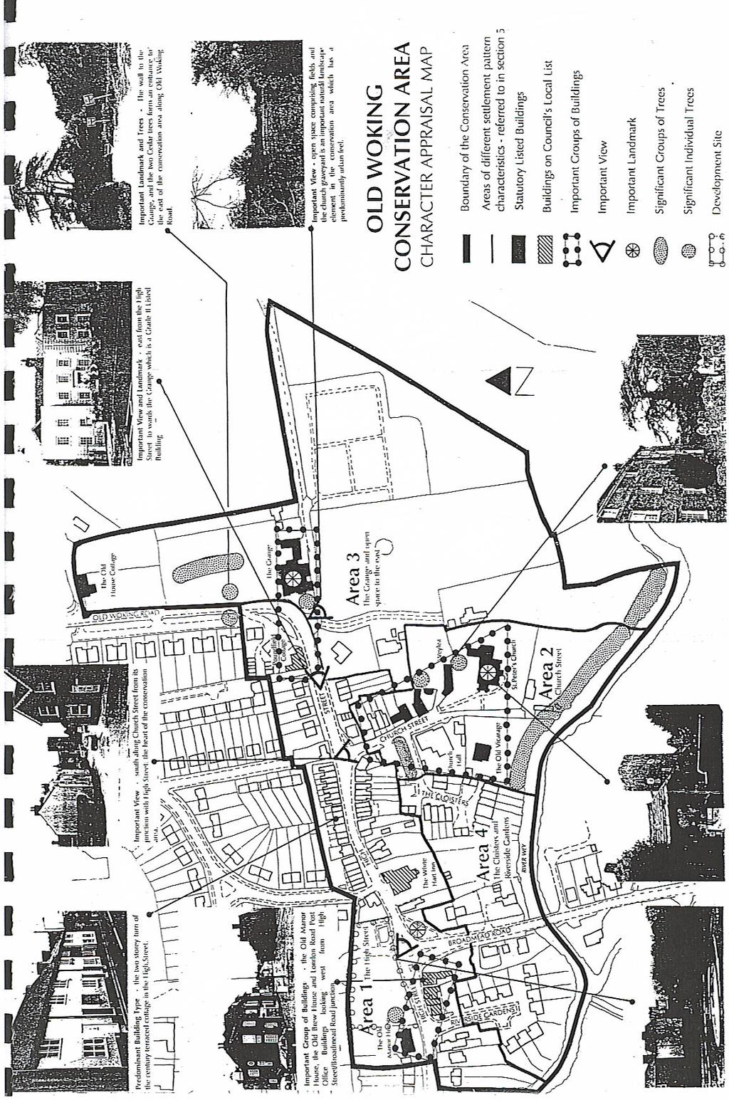
2 1. BACKGROUND OLD WOKING CONSERVATION AREA STATEMENT: CHARACTER APPRAISAL and DESIGN GUIDANCE Old Woking was the first conservation area to be designated in Woking Borough. It was designated in September 1975, under the 1967 Civic Amenities Act, in order to protect the areas special architectural and historic character. The boundary of the area is shown on the Character Appraisal Map. The conservation area forms the heart of Old Woking village centre which is located on the southern edge of the urban area, approximately one mile to the south of the modern town centre of Woking. The area is low lying and abuts the flood plain of the River Wey on its southern boundary where Broadmead Road forms a crossing point. Originally known as Woccingas, the village was the first settlement around which the modern town of Woking developed. Evidence of Romano-British occupation has been found nearby. The development of the settlement also has close links with that of the Woking Manor, which became Henry VIII s royal residence of Woking Palace during the 16th Century. The ruins of this site, which is a Scheduled Ancient Monument, lies immediately to the east of the village, outside the conservation area boundary. During the 17th Century, Old Woking prospered as a small market centre and many of the buildings from this period and the historic street pattern remain today. Following the loss of its royal connections the village eventually declined as a trading centre being superseded by the railway town of Woking during the 19th Century. 2. PURPOSE OF STATEMENT This document describes what it is about the qualities of the character and appearance of the Old Woking Conservation Area which makes it special and that need to be protected and enhanced. A short summary of this statement is set out in Appendix1. The purpose of the document is to: define the detailed features of the conservation area which contribute to its special character that need to be protected; provide guidance for the design, layout and material finish of developments and other works; assist the Council in making decisions on planning submissions to control the quality of design in new development which could affect the area s character; assist householders in the preservation and restoration of period dwellings; assist in the preparation of proposals for the enhancement of the conservation area. 3. SPECIAL PLANNING CONTROLS The Council has special planning controls within a conservation area under the Planning (Listed Buildings and Conservation Areas) Act 1990 which are used to protect its character. These particularly relate to: the control of demolition; the control over the detailed design of new development (including extensions) to ensure they are sympathetic to the area s character, and the control of all works to trees in the area. However, in exceptional circumstances, the Council may seek to introduce additional planning controls to cover more minor elements of building work, where this is considered essential to protect the special character of the area. All the planning controls are explained in more detail in Appendix 2. 2

3 4. DETAILED CHARACTER APPRAISAL The following range of features have been considered as part of the detailed appraisal of the areas special character. Pattern of Settlement street pattern plot characteristics views and landmarks Other Features road and footway surfaces street furniture signs, advertisements and satellite dishes open spaces and natural landscape Buildings (Design,Materials, and Uses) historic and other important buildings predominant building types use of buildings shopfront design boundary treatments Each of the following sections provides a detailed description of the areas predominant characteristics and where appropriate these are referred to on the Appraisals Map. Highlighted in bold text at the end of each section, are the main points of concern which should be addressed in any future developments. 5. PATTERN OF SETTLEMENT The existing street pattern was established during the 17th Century when Old Woking developed around a market square, now the junction with the High Street and Church Street, close to the main river crossing at Broadmead Road. The village has continued to expand along these routes in the form of ribbon development, reinforcing the original historic street pattern which still dominates the character of the village centre today, as shown on the maps below, circa 1800 and Circa 1800 Circa
4 Within the Centre there are distinct changes in the character of the street pattern and associated plot dimensions, which are referred to in the text, that have influenced the form of development in the following parts of the conservation area ; Area 1 : The High Street Area 2 : Church Street Area 3 : The Grange and area to the east Area 4 : The Cloisters and Riverside Gardens 5.1 Street Pattern Area 1. Within the western section of the High Street the street pattern is dominated by the close relationship of continuous building frontages which line both sides of the narrow street. As buildings directly adjoin the narrow pavements, which are less than 1.0 metres wide in many places, there is a very strong sense of enclosure throughout much of this section of the street which is only relieved by the brief widening at the junction of High Street and Church Street, and at the Broadmead Roundabout. Area 2. Within Church Street the pattern of development is much more fragmented and informal, with variations in the depth of building line together with the irregular separation of buildings, including both attached and individual detached dwellings, which break up the frontage. However, there is considerable sense of enclosure with many buildings directly adjoining the narrow road, there being no footpath on the eastern side of the street. Area 3. The eastern section of the area is relatively undeveloped with only a handful of widely spaced individual buildings, set amidst large tracts of open land, although much of this is hidden from public view. Area 4. The modern developments of the Cloisters and Riverside Gardens have cul-de-sac layouts which have little relationship with the historic street pattern. Development proposals should reinforce characteristics of the historic street layout in each area, particularly where there are continuous building lines, or where frontages are close to, or abutting the back of, the footways. Car parking where required should be located to the rear of the buildings in these locations. 5.2 Plot Characteristics Areas 1&2. The predominant form of building plots, which have relatively narrow frontages irrespective of plot depth, owe their characteristics to the Medieval origins of the Centre. This characteristic is particularly reflected in the narrow fronted format of buildings within the High Street including more recent buildings, together with the north eastern part of Church Street. 4

5 Areas 2&3. There are a small number of substantially larger plots, containing larger buildings to the south of Church Street and the eastern section of the conservation area which originally belonged to wealthy landlords such as the lords of the manor or the church. Area 4. This is a modern housing estate with conventional house plots. Where there is a proposal to amalgamate a number of the predominantly narrow frontage building plots, the appearance of the building frontage should be subdivided into a series of narrow bays to reflect the vertical rhythm of the street scene. Elsewhere, the plot size should reflect those in the immediate vicinity. 5.3 Views and Landmarks There are a number of significant views and landmarks within the area which are identified on the appraisal map as follows ; St. Peter s Church with its distinctive square tower is the most significant landmark in the centre which can be viewed from the Broadmead Roundabout and from the junction of High Street with Church Street. The Grange, which is sited on the sharp corner at the eastern end of the High Street, together with its high boundary wall and the associated Holm Oak and Cedar Trees. These features form a smaller but significant landmark which can be viewed from the western end of the High Street. Any new developments should retain and enhance the views and landmarks which have been identified, as shown on the Appraisal Plan. 6. BUILDING DESIGN, MATERIALS AND USES 6.1 Historic and Other Important Buildings There are a large number of historic buildings from a variety of periods and styles within the conservation area. Several properties are protected by statutory listing and a number of others are included on the Council s Local List which are shown on the appraisal plan. Many of these have group value. Most of the older and most architecturally and historically important buildings which are statutory listed, including St. Peter s Church which is Grade I, are located within Church Street which is the historic core of the conservation area. Listed Buildings in Church Street which form the Historic Core 5
. The Council will also give particular attention to protecting public views of the setting of these buildings, and those identified as having group value.")

6 Where formal consent is required, the Council will resist demolition and works to adversely alter all period buildings in the conservation area, particularly those on the Statutory or Local List (see Appendix 2). The Council will also give particular attention to protecting public views of the setting of these buildings, and those identified as having group value. Any proposed development should take its design cues from the historic buildings in the conservation area, including the form, scale, materials used, and detailing, in order to enhance or maintain the character of the conservation area. 6.2 Predominant Building Types There are a variety of building types in the conservation area, although these all have traditional forms, largely of brick construction under a steep clay tiled roof. Within the High Street two storey terraced cottages with narrow frontages predominate. Elsewhere there is a much wider variety of building types and styles, including larger, detached, two and three storey, wide fronted Georgian and Victorian villas as well as conventional two storey semidetached houses. However, most properties have elevations which are sub-divided into a number of narrow bays. Any new development should reinforce the character and appearance of the street frontage in terms of height and scale, and should take its design cues from appropriate buildings in the immediate locality. New developments should have pitched roofs of at least 45, which should normally terminate with gable ends. It is unlikely that pitched roofs below 35 or flat roofs will be permitted. Where possible, chimneys should be provided in order to retain a visually interesting roofscape. 6.3 Windows and Doors. Most buildings have limited window openings. These are usually small in size, and approximate to 1/3 of the building frontage. Both traditional casement and sash windows are to be found subdivided into smaller lights, mostly constructed from painted softwood. Most doors are of painted solid plank construction. Both windows and doors often have detailed brickwork above them. In appropriate locations, new buildings should have front doors and windows facing the main street in order to retain the character of the street frontage. New buildings should use traditional joinery for doors and window frames. Both traditional sliding sash and casement windows are appropriate, with traditional subdivided glazing. The ratio between the proportion of solid frontage to void (the space given to glazing) on any new development should not exceed ½ of the building frontage. The use of UPVC frames and doors or the introduction of roof lights or velux windows on elevations in view of the street will be discouraged. The Council will monitor the area and seek additional planning control over these elements if evidence supports action. Both traditional sliding sash and opening casement windows are appropriate for new developments 6

7 6.4 Materials and Colour. The most commonly used materials and features. A limited range of building materials are used in the conservation area although local Surrey red/orange facing bricks predominate. A number of buildings have used painted render, and stucco, such as the Old Vicarage and the Grange. Several have clay tile hanging to first floor elevations, such as the White Hart Inn. There is a mixture of roofing materials using both plain clay tiles and slates. A range of different colours are used within the conservation area although brick or tile hanging, together with white or neutrally painted render predominate. Most window frames and other joinery are white or black, although the door colours within the area vary widely. New development should be constructed of local Surrey red/orange brick with either plain clay roof tiles, or slate roofs. The use of materials such as pebble dash, render, stucco, and tile hanging could also be used where nearby properties have used these materials. The use of flint may also be acceptable as used on St.Peter s Church and the village sign at Broadmead Roundabout. 6.5 Use of Buildings The conservation area is predominantly a residential area, although there are a number of small businesses and shops which contribute to the life of the area. New business uses should not be permitted in the conservation area where this would affect its residential character. However, in exceptional circumstances, where the future of an historic building is at risk, an alternative economic use may be considered where it is essential to ensure the fabric of that building is maintained for its long term preservation. Shopfronts There is a mixture of shopfront designs in the conservation area. However, only those which incorporate traditional elements enhance the character and appearance of the area. 7
8 The traditional elements of a shopfront. Where there is a proposal to either alter a shop frontage or provide a new shop unit within the conservation area, the design should incorporate traditional shop front elements as shown above. The design should also take into consideration the overall architectural design of the building. Lighting if any, should be externally illuminated and discreet. Internally illuminated projecting box signs and fascias will not be permitted. 6.6 Boundary Treatments In most of the conservation area, building frontages directly join the pavement without any intervening boundary which gives a sense of enclosure along the already narrow street. In some locations buildings are set back using a variety of boundary forms, with low walls and wooden fences being the most common. Boundary treatments for new developments should reflect the predominant treatment in the area. Where appropriate building frontages should directly join the pavement without any further means of enclosure. Planning consent will not normally be granted for a development which introduces an incongruous style of boundary treatment, or which changes the original pattern of boundary style. 7. OTHER FEATURES 7.1 Road and Footway Surfaces The majority of the roads and public footways in the conservation area are constructed of tarmacadam although the road surface in Church Street comprises natural coloured bound gravel with granite kerbs. New footways should remain narrow and surface materials should be of high quality. Where appropriate materials such as natural stone or traditional blue clay pavers are preferred as an alternative to tarmacadam. 8


9 7.2 Street Furniture The use of street furniture can enhance the character and appearance of a conservation area if located sensitively. However, it can also create a cluttered street scene. In the Old Woking conservation there is a mixture of street furniture designs. A number of these, including the hanging basket columns, village sign, and seats, are of traditional design and cast iron construction and contribute to the character and appearance of the area, as they are carefully located. However, many other elements, such as the modern street lamps, parking restriction signs, and overhead wires, create clutter and detract from the appearance of the street scene. Any new street furniture should complement the character and appearance of the conservation area such as the use of elegant black cast iron equipment. Where new development is proposed, services such as telephone and cable wires should be located underground, and street signs carefully sited. 7.3 Signs, Advertisements and Satellite Dishes. Many of the existing small businesses in the conservation area have signs and fascia boards which are out of scale with the shopfront, usually constructed of upvc or aluminium. There are two projecting signs, one a box sign above the Chinese take-away at 181 High Street, and the other a simple hanging sign by the post office. A number of properties also have satellite dishes, although these are mainly located on the rear of properties away from public view. Fascia signs and other advertisements should be of a high standard of design and be of a traditional format with clear lettering in scale with the fascia panel and that of the overall shopfront. Free-standing lettering applied directly to the masonry is often less incongruous. No advertisements should be positioned above the ground floor fascia level. Satellite dishes should always be positioned away from the public street frontage, such as at the rear of the property and should be of a standard size. Irrespective of location, the colour of satellite dishes is an important element to consider and should blend with its background, such as using brown equipment against brickwork. 9
10 (Further detailed advice is contained in the Department of Environment, Transport and the Regions document entitled A Householders Planning Guide for the Installation of Satellite Television Dishes available from the Council). 7.4 Open Spaces and the Natural Landscape The conservation area is predominantly urban in character. However there are a number of important trees, open spaces, and other natural landscape elements, (including the River Wey) which contribute to the character of the conservation area. Areas of open space and other natural landscape elements will be retained. Development will not be permitted which will result in the loss of or have a detrimental impact on the quality of these natural features. The Council will seek to protect trees of amenity value in the conservation area against felling and inappropriate works. The Council will also promote the planting of new trees of suitable species to maintain the areas landscape character (details of the planning controls over trees are given in Appendix 2 and the general criteria for selection of trees for Tree Preservation Order are found in Appendix 3). 7.5 Negative Features There are relatively few negative features in the area, although a small number of the existing shops and businesses have incongruous signs and display windows. 10
11 Appendix 1 OLD WOKING CONSERVATION AREA STATEMENT Character Appraisal and Design Guidance Summary 1.0 Purpose This document provides a summary of the main features that make a special contribution to the character and appearance of the Old Woking Conservation Area which the Council seeks to protect and enhance through its statutory planning controls. Householders and designers seeking to undertake any form of development in the area should ensure their proposals preserve or enhance the areas character, with particular reference to the points made in bold text below. A full copy of the Guidance can be obtained from the Council on request. 2.0 Background of Designation The Conservation Area was designated in September 1975, as shown on the attached Map. The Conservation Area forms the historic core of the Village Centre, which is an ancient settlement that is closely linked with Woking Manor since at least the 13 th Century. The village prospered as a market centre, particularly during the 17 th Century, and many of its fine historic buildings together with its historic street pattern remain from this time, which dominate the character of the Conservation Area. 3.0 Pattern of Settlement The character of the Conservation Area varies within different sections. Within the High Street section the street pattern is dominated by continuous building frontages which closely line both sides of the street, directly abutting the narrow pavements. Narrow building plots predominate. Within Church Street the pattern is more fragmented but still dominated by buildings, although these include both attached and detached buildings with irregular depths of frontage and spacing between them. Building plot characteristics vary widely becoming much larger to the south. The eastern section of the area is relatively undeveloped with only a handful of individual dwellings set within large plots of land, mostly hidden from view. The developments of the Cloisters and Riverside Gardens to the west are modern culsde-sac which have little relationship with the historic street pattern. Building plots are modest but slightly larger than those of older houses within the High Street. There are a number of significant views created by the arrangement of important buildings in the street pattern. Notably views of St. Peter s Church, from the junctions of Church Street with High Street and Broadmead Roundabout. Also views of the Grange from the eastern half of the High Street. New developments should reinforce the characteristics of individual parts of the historic street pattern, particularly where building frontages abut the highway. 4.0 Building Character There are a wide number of historic buildings from a variety of periods and styles within the area, with a mix of uses, although residential use predominates. 4.1 Important Buildings. The following have special interest; St. Peter s Church is Grade I statutory listed. The Old Manor House, The Old Vicarage, Weylea Cottage, Church Cottage, Wey & Lea Cottage, The Grange, and the Old House Cottage, are all Grade II statutory listed. 11
12 The Old Brew House, White Hart Inn and Poundfield Cottage are included on the Council s local List. The Council will resist demolition and works to adversely alter all period buildings in the area, particularly those on the statutory or local list. 4.2 Building Style. There are a variety of periods and styles within the area, although all have traditional forms. Within the High Street two storey terraced cottages with narrow frontages predominate. Elsewhere there are a much wider of buildings, including larger two and three storey Georgian and Victorian villas as well as more conventional semidetached houses. However most buildings have elevations which are divided into a number of narrow bays. Roofs are mostly of 45 pitch construction using either plain clay tiles or slates. Most have gabled forms positioned either to the front or side of the building and many retain their original chimneys which punctuate the roofscape. Doors and windows are limited in size, with traditional ratios of solids to voids (1/3 to 2/3) and positioned to define narrow bays to building elevations. Both traditional casement and sliding sash windows are found subdivided into smaller lights, mostly constructed from painted softwood. Most doors are of solid plank construction. A limited range of facing materials are used, although local red/orange stock bricks predominate. A number of have painted render and stucco, such as the Old Vicarage and The Grange, and a small number have hanging tiles, such as the White Hart P.H. Both plain clay tiles and slates are used for roofing. A number of commercial buildings have retained their traditional shopfronts. Those with modern shopfronts which do not incorporate traditional elements appear incongruous. New developments should reinforce the character and appearance of the street frontage in terms of height, form, scale,and material finish, and should take their design cues from appropriate buildings in the immediate locality. Buildings should have traditional pitched roof forms and the pattern of doors and windows should define narrow bays with traditional ratios of solids to voids for openings. All works to either alter or extend existing period buildings should closely match their architectural detail and material finish. 5.0 Other Features Boundaries to properties are mostly defined by the buildings themselves throughout the area, with limited use of walls, fencing or hedging. This arrangement gives the Village Centre a very urban quality. Boundary treatment should reinforce the urban quality of the Village centre. There are a number of important individual trees within the area which are protected by Tree Preservation Orders. The Council will resist the felling or undertaking of any inappropriate works to trees which are subject to Tree Preservation Orders ( TPO ). 12
13 Appendix 2 ADDITIONAL PLANNING CONTROLS WITHIN A CONSERVATION AREA The Council has special planning controls in a Conservation Area in addition to its normal planning powers, as set out below : 1. Demolition Conservation Area Consent is normally required before any building or structure can be demolished within the area, including certain walls and outbuildings. This provision applies unless the building has a volume less than 115 cubic metres or was constructed under permitted development rights, such as garden shed. Formal Listed Building Consent is also required for works to demolish or alter the appearance or setting of a Statutory Listed Building. It is an offence to undertake demolition in a conservation area, where approval is required, or any works to a listed building, without prior consent. Conviction is punishable by fine or imprisonment. 2. Development The following additional restrictions on development require planning permission : Any extension which would increase the volume of an original dwelling by more than 10% or 50 cubic metres (whichever is largest, up to a maximum of 115 cubic metres. All additional buildings within the site over 10 cubic metres, regardless of location are treated as extensions to the dwelling ). An extension or any kind of alteration to a dwelling which would materially alter the appearance of the roof. Cladding the outside of a building with stone, tiles timber, render or any other material which would alter its appearance. The installation of a satellite dish on any part of the building visible from the highway. 3. Design of New Development The Council has a special duty when considering applications for development in a conservation area to preserve or enhance the character or appearance of the area. All proposals will be carefully examined to ensure that all elements of the proposal, particularly; layout, bulk, height, form, elevational design, colour and material finish are appropriate in scale and character for that particular part of the conservation area. In this regard only fully detailed planning applications will normally be considered and must show both plan and elevational relationships with adjoining buildings. All applications in conservation areas are advertised to allow for public comment. 13
14 4. Minor Alterations and Additions Small changes to residential buildings such as the alteration or replacement of original windows do not normally require permission unless the property is statutory listed. However, the continued loss of architectural detail can gradually erode the character and appearance of an area through the culmination of minor changes. The Council will monitor the conservation area and if evidence supports will seek the introduction of an Article 4(2) Direction to remove certain rights of permitted development in the area. This would enable such minor matters to be brought under planning control, where this is considered necessary to protect the areas special character. 5. Trees Anyone proposing to do work on a tree* in a Conservation Area, including; lopping, topping or felling, is required to give the Council six weeks notice of their intentions in writing. This period allows the Council to inspect the tree so that it can consider if it should be the subject of Tree Preservation Order (T.P.O.). No works can be undertaken on trees which are protected by a T.P.O. until formal consent has been granted by the Council. * For these purposes a tree must have a trunk with a diameter exceeding 75mm when measured at chest height ( 1.5 metres above the ground). It is an offence to undertake works on a protected tree without prior consent which is punishable by fine. The Council may use the powers given through the Environment Protection Act 1995 to ensure property owners maintain their trees and shrubs if they are causing an obstruction of the highway. 14
15 Appendix 3 Criteria for the Selection of Trees for Protection by Tree Preservation Order (TPO) The following criteria on health and amenity value will be used in the selection of trees to be protected by Tree Preservation Orders: 1. Health and Structural Condition Condition in relation to type, age and position ( ref. BS ) Evidence of; storm damage, root lifting, dead/diseased wood, excessive epicormic growth, weak forks etc. that would reduce selection. Type and position of tree is appropriate for its location. Reasonable life expectancy without compromising adjacent buildings or infrastructure. Need for corrective action to maintain the tree in a safe condition. 2. Amenity Value a) Visual significance within the landscape. Visibility of the tree from surrounding public areas (or those with limited public access). Prominence of the tree as a local focal point or landmark. Popularity of the location, i.e. busy or seldom visited. Contribution to the local landscape character. Contribution as an element of a landscape feature, e.g. an Avenue. Contribution in screening out an unsightly/incongruous feature in the landscape. b) Form of Tree. Shape and balance of tree in representing typical characteristics of species. Particularly unusual or distinctive characteristics of trees form. Extent of impact that past works or natural damage have made on the form of the tree. c) Scarcity Rarity of species or particular cultivar. Special historical associations with site or locality. d) Potential Future Benefit Value in contribution to future landscape character of area. 3. Other Factors e.g. contribution to the setting of an historic building. 15
16 16
17 17
UPPER GORDON ROAD TO CHURCH HILL, CAMBERLEY CONSERVATION AREA
 Introduction This leaflet explains the purpose of conservation areas and the implication of their designation for residents, property owners and the Council. It provides you with a plan of the area and
RESIDENTIAL BOUNDARY TREATMENT
 STATUS OF SUPPLEMENTARY PLANNING GUIDANCE ON RESIDENTIAL BOUNDARY TREATMENT Status This Planning Guidance, which is supplementary to Policy BE1 of the Woking Borough Local Plan 1999, has been formally
INTRODUCTION CURRENT APPLICATION
 05/01805/FUL & 05/01807/LBC ERECTION OF A SINGLE DWELLING HOUSE WITH ANCILLARY ACCOMMODATION AT Flamingo Zoological Gardens, Olney Road, Weston Underwood FOR Mr A J Crowther (as amended by letter dated
MATURE SUBURBS RESIDENTIAL DEVELOPMENT GUIDELINES
 MATURE SUBURBS RESIDENTIAL DEVELOPMENT GUIDELINES DRAFT FEBRUARY 2005 BIRMINGHAM CITY COUNCIL 1 Introduction Mature Suburbs Residential Development Guidelines - Interim Supplementary Planning Advice -
7.1 Area 1: Haslemere Conservation Area
 7.1 Area 1: Haslemere Conservation Area Detailed map of Haslemere Town Conservation Area as of 2006 Crown copyright and database right 2011 Ordnance Survey LA100025451 27 The Conservation Area is characterised
DESIGN GUIDANCE NOTE NO: 5 EXTENSIONS TO HOUSES
 DESIGN GUIDANCE NOTE NO: 5 EXTENSIONS TO HOUSES This note is one of a series providing design guidance for development in the borough. It explains the criteria used by the council to decide planning applications
SOUTH CAMBRIDGESHIRE DISTRICT COUNCIL. Executive Director (Operational Services) Corporate Manager (Planning and New Communities)
 Corporate Manager (Planning and New Communities)") SOUTH CAMBRIDGESHIRE DISTRICT COUNCIL REPORT TO: Planning Committee 12 January 2011 AUTHOR/S: Executive Director (Operational Services) Corporate Manager (Planning and New Communities) Notes: S/1848/10
SOUTH CAMBRIDGESHIRE DISTRICT COUNCIL REPORT TO: Planning Committee 12 January 2011 AUTHOR/S: Executive Director (Operational Services) Corporate Manager (Planning and New Communities) Notes: S/1848/10
Derry City and Strabane District Council Planning Committee Report
 Derry City and Strabane District Council Planning Committee Report COMMITTEE DATE: 23 rd March 2016 APPLICATION No: APPLICATION TYPE: PROPOSAL: LOCATION: APPLICANT: LA11/2015/0395/F Residential Development
2014/0590 Reg Date 26/06/2014 Chobham
 2014/0590 Reg Date 26/06/2014 Chobham LOCATION: PROPOSAL: TYPE: APPLICANT: OFFICER: ASCOT PARK POLO CLUB, WESTCROFT PARK FARM, WINDLESHAM ROAD, CHOBHAM, WOKING, GU24 8SN Erection of a two storey detached
DRAFT CONSERVATION AREA APPRAISAL CHAILEY GREEN DESIGNATED
 DRAFT CONSERVATION AREA APPRAISAL CHAILEY GREEN DESIGNATED 16.06.76 DRAFT CHAILEY GREEN CONSERVATION AREA APPRAISAL 1 SUMMARY 1.1 Key Positive Characteristics 1.2 Recommendations 2 INTRODUCTION 2.1 The
PLANNING COMMITTEE. 14 October 2014
 AGENDA ITEM NO 8 PLANNING COMMITTEE 14 October 2014 APPLICATION NUMBER : CA//14/01744/FUL PROPOSAL : Extension and conversion of roof space of an existing detached bungalow together with enhanced parking
Land Adj. 63 Sunny Bank Road, Sutton Coldfield, Birmingham, B73 5RJ
 Committee Date: 11/07/2013 Application Number: 2013/03520/PA Accepted: 20/05/2013 Application Type: Full Planning Target Date: 15/07/2013 Ward: Sutton Vesey Land Adj. 63 Sunny Bank Road, Sutton Coldfield,
SOUTH CAMBRIDGESHIRE DISTRICT COUNCIL. Planning and New Communities Director
 SOUTH CAMBRIDGESHIRE DISTRICT COUNCIL REPORT TO: Planning Committee 5 June 2013 AUTHOR/S: Planning and New Communities Director S/0747/13/FL HISTON Construction of Car Park at Histon Baptist Church, Station
Persimmon Homes Thames Valley Date received: 2 nd April week date(major): 2 nd July 2014 Ward: Nascot
: 2 nd July 2014 Ward: Nascot") PART A Report of: DEVELOPMENT MANAGEMENT SECTION HEAD Date of Committee: 26 th June 2014 Site address: Rounton, 28, Nascot Wood Road Reference Number: 14/00497/REM Description of Development: Reserved
PART A Report of: DEVELOPMENT MANAGEMENT SECTION HEAD Date of Committee: 26 th June 2014 Site address: Rounton, 28, Nascot Wood Road Reference Number: 14/00497/REM Description of Development: Reserved
Character Area 1: Town Core
 Character Area 1: Town Core Map S 354 Copyright Cotswold District Council 109 Character Area 1: Town Core Key Characteristics 355 356 357 358 359 360 361 362 363 364 365 366 367 368 369 370 Copyright Cotswold
GREAT WESTERN SQUARE & ENVIRONS
 GREAT WESTERN SQUARE & ENVIRONS Draft Architectural Conservation Area Report Character Appraisal and Policy Framework 20 1 Architectural Conservation Area Report: GREAT WESTERN SQUARE & ENVIRONS Draft
ST. LUKE'S. planning consent will not be given for residential uses of ground floor and basement premises currently in non-residential use;
 CA SIXTEEN ST. LUKE'S 16.1 The Council will operate special policies in the St. Luke s Conservation Area in order to preserve and enhance the special character and appearance of the area. 16.2 Lying in
Statement of Community Involvement LAND OFF SOUTHDOWN ROAD HORNDEAN, HAMPSHIRE
 LAND OFF SOUTHDOWN ROAD HORNDEAN, HAMPSHIRE CONTENTS Page 1. Introduction 3 2. Pre-application Discussions 4 3. The Consultation Process 5 4. Consultation Feedback 7 5. Responses to Consultation Feedback
Ward: West Wittering. Proposal Change of use from public highway pavement to residential garden use.
 Parish: West Wittering Ward: West Wittering WW/17/03295/FUL Proposal Change of use from public highway pavement to residential garden use. Site Izora 1 Watersedge Gardens West Wittering PO20 8RA Map Ref
Purpose of the Variation: The purpose of an ACA is to protect and enhance the special character of the ACA by:
 To the Lord Mayor and Report No. 202/2017 Members of Dublin City Council Report of the Assistant Chief Executive Proposed Draft Variation (No. 2) of Dublin City Development Plan 2016 2022 Designating Hollybrook
Warren Farm, Ampthill
 1 Welcome The developers of the Warren Farm site, Bloor Homes and Connolly Homes, are holding this exhibition on the emerging Design Codes for the development prior to their formal submission to Central
Site north of Hattersley Road West (east of Fields Farm Road), Hattersley
, Hattersley") Application Number 17/00982/REM Proposal Site Applicant Recommendation Reason for report Application for the approval of reserved matters (means of access, landscaping, layout, scale and appearance) relating
Application Number 17/00982/REM Proposal Site Applicant Recommendation Reason for report Application for the approval of reserved matters (means of access, landscaping, layout, scale and appearance) relating
DEVELOPMENT MANAGEMENT REPORT
 ITEM A08-1 DEVELOPMENT MANAGEMENT REPORT TO: BY: DATE: DEVELOPMENT: SITE: WARD: APPLICATION: APPLICANT: Development Management Committee Development Manager Proposed live/work unit in connection with existing
Report Author/Case Officer: Joanne Horner Contact Details:
 APP 04 Application Number: 16/00140/FUL Other Two storey side extension to existing dwelling and formation of hard standing to provide parking for number 54 (Resubmission of withdrawn application 15/02852/FUL)
DESIGN & ACCESS STATEMENT
 DESIGN & ACCESS STATEMENT Land to the South East of the A495, Bronington Erection of 31 Dwellings (27 dwellings and 4 bungalows including 4 Affordable Dwellings), Realignment and Improvements to A495 (including
STRENSALL RAILWAY BUILDINGS CONSERVATION AREA APPRAISAL. In association with Strensall with Towthorpe Parish Council
 STRENSALL RAILWAY BUILDINGS CONSERVATION AREA APPRAISAL In association with Strensall with Towthorpe Parish Council CONTENTS Page 1 Introduction 2 2 Location and Context 3 3 Topography and Setting 4 4
5 Gratton Terrace London NW2 6QE. Reference: 17/5094/HSE Received: 4th August 2017 Accepted: 7th August 2017 Ward: Childs Hill Expiry 2nd October 2017
 Location 5 Gratton Terrace London NW2 6QE Reference: 17/5094/HSE Received: 4th August 2017 Accepted: 7th August 2017 Ward: Childs Hill Expiry 2nd October 2017 Applicant: WSD (Gratton) Ltd Proposal: The
Harrow Lane, St Leonards-on-Sea, East Sussex, TN37 7JZ ERECTION OF 113 DWELLINGS TOGETHER WITH ESTATE ROADS (DETAILED SUBMISSION)
") AGENDA ITEM NO: Report to: PLANNING BOARD Date: 10 September, 2003 Report from: Borough Planning Officer Application Address: Proposal: Application No: Recommendation: Ward: File No: Applicant: Interest:
AGENDA ITEM NO: Report to: PLANNING BOARD Date: 10 September, 2003 Report from: Borough Planning Officer Application Address: Proposal: Application No: Recommendation: Ward: File No: Applicant: Interest:
Welcome. Land adjacent Sandy Lane WALTHAM CHASE THE PROPOSED SITE
 Land adjacent Sandy Lane WALTHAM CHASE Existing Linden Homes developments Welcome Welcome to Linden Homes Southern s ( Linden ) public exhibition about its proposals for a range of high-quality homes for
Mr & Mrs Connolly per Pump House Designs Pump House Yard The Green SEDLESCOMBE, East Sussex. TN33 0QA
 AGENDA ITEM NO: 5 (c) Report to: PLANNING COMMITTEE Date: 03 June 2015 Report from: Head of Housing and Planning Services Application Address: Proposal: Application No: Recommendation: Ward: File No: Applicant:
3(iv)(b) TCP/11/16(29)
(b) TCP/11/16(29)") 3(iv)(b) TCP/11/16(29) TCP/11/16(29) Planning Application 09/02229/AML Erection of a dwellinghouse, garage with upper floor accommodation and stables (Approval of Matters Specified by Conditions) at land
3(iv)(b) TCP/11/16(29) TCP/11/16(29) Planning Application 09/02229/AML Erection of a dwellinghouse, garage with upper floor accommodation and stables (Approval of Matters Specified by Conditions) at land
2014/0943 Reg Date 06/11/2014 Lightwater
 2014/0943 Reg Date 06/11/2014 Lightwater LOCATION: PROPOSAL: TYPE: APPLICANT: OFFICER: LAND REAR OF 4, 6 & 8 MACDONALD ROAD, LIGHTWATER, GU18 5TN Erection of 2 linked-detached two storey dwellings with
Commenting on Planning Applications: MHPRA Policy
 Commenting on Planning Applications: MHPRA Policy millhillparkacton.org Our Area The Mill Hill Park Residents Association covers the Mill Hill Park Conservation Area in Acton, W3. Objectives We aim to
SOUTH CAMBRIDGESHIRE DISTRICT COUNCIL. REPORT TO: Planning Committee 1 April 2015 Planning and New Communities Director
 SOUTH CAMBRIDGESHIRE DISTRICT COUNCIL REPORT TO: Planning Committee 1 April 2015 AUTHOR/S: Planning and New Communities Director Application Number: Parish(es): Proposal: Site address: Applicant(s): Recommendation:
PART AOTEA PRECINCT
 CONTENTS... PAGE AOTEA PRECINCT...4 14.5.1 INTRODUCTION...4 14.5.2 RESOURCE MANAGEMENT ISSUES...4 14.5.3 RESOURCE MANAGEMENT OBJECTIVES AND POLICIES... 4 14.5.4 RESOURCE MANAGEMENT STRATEGY...5 14.5.5
BLACKHEATH SQUASH CLUB Blackheath Sports Club, Rectory Field, Charlton Road, London, SE7 7EY. Planning, Design and Access Statement
 Planning, Design and Access Statement Revised: 28 th Jan 2016 Peter Pendleton & Associates Ltd Introduction Planning permission will be sought for a refurbishment of existing courts and extension to provide
Sunday's Well Proposed Architectural Conservation Area
 1 Sunday's Well Proposed Architectural Conservation Area D A E C B F Old City Gaol Saint Vincent s RC Church Saint Albert s Former Good Shepherd Convent Boundary of Area Sunday's Well is an area located
Purpose of the Variation: The purpose of an ACA is to protect and enhance the special character of the ACA by:
 To the Lord Mayor and Report No. 201/2017 Members of Dublin City Council Report of the Assistant Chief Executive Proposed Draft Variation (No. 1) of Dublin City Development Plan 2016 2022 Designating Haddon
EAST OF ENGLAND OFFICE
 Mr Philip Isbell Direct Dial: 01223 582751 Mid Suffolk District Council 131 high Street Our ref: P00524468 Needham Market Ipswich Suffolk IP6 8DL 18 January 2017 Dear Mr Isbell T&CP (Development Management
Conservation Area Designation, amendments and Review
 Conservation Area Designation, amendments and Review Location: Any area largely confined to Park Road and St. James Avenue which includes the following properties: St. James Church, St. James Road; No.
PART 2 SOUTH DOWNS NATIONAL PARK AUTHORITY SECTION 1 SCHEDULE OF APPLICATION RECOMMENDATIONS
 42 PART 2 SOUTH DOWNS NATIONAL PARK AUTHORITY PLANNING COMMITTEE REPORT OF THE SERVICE MANAGER PLANNING DEVELOPMENT Applications to be determined by the council on behalf of the South Downs National Park
BROADHEMBURY DESIGN STATEMENT
 BROADHEMBURY DESIGN STATEMENT As drawn up by Broadhembury Parish Council during the development of a Parish Plan and adopted at its meeting on 17 th May 2010 BROADHEMBURY DESIGN STATEMENT Contents Introduction
REFERENCE: B/03745/12 Received: 02 October 2012 Accepted: 05 October 2012 WARD(S): Totteridge Expiry: 30 November 2012.
: Totteridge Expiry: 30 November 2012.") LOCATION: 15A Pyecombe Corner, London, N12 7AJ REFERENCE: B/03745/12 Received: 02 October 2012 Accepted: 05 October 2012 WARD(S): Totteridge Expiry: 30 November 2012 Final Revisions: APPLICANT: PROPOSAL:
LOCATION: 15A Pyecombe Corner, London, N12 7AJ REFERENCE: B/03745/12 Received: 02 October 2012 Accepted: 05 October 2012 WARD(S): Totteridge Expiry: 30 November 2012 Final Revisions: APPLICANT: PROPOSAL:
49 Broughton Avenue London N3 3EN
 Location 49 Broughton Avenue London N3 3EN Reference: 17/3448/RCU Received: 30th May 2017 Accepted: 1st June 2017 Ward: Finchley Church End Expiry 27th July 2017 Applicant: Mr P Atwal Proposal: Erection
Schedule of Planning Applications Committee Date: 23 May Reference: 06/17/0726/F Parish: Hemsby Officer: Mr J Beck Expiry Date:
 Schedule of Planning Applications Committee Date: 23 May 2018 Reference: 06/17/0726/F Parish: Hemsby Officer: Mr J Beck Expiry Date: 22-05-2018 Applicant: Proposal: Site: Mr Gillett Change of use to the
APPENDIX MATAKANA COMMERCIAL URBAN DESIGN GUIDELINES
 APPENDIX MATAKANA COMMERCIAL URBAN DESIGN GUIDELINES 1.0 INTRODUCTION The following urban design guidelines are to be utilised by landowners, planners and other persons involved in development at early
1 The development hereby permitted shall be carried out in accordance with the following approved plans:
 Location 59 Greenway Close London N20 8ES Reference: 16/00011/HSE Received: 30th December 2015 Accepted: 7th January 2016 Ward: Totteridge Expiry 3rd March 2016 Applicant: Mr Ankit Shah Proposal: Part
DESIGN & ACCESS STATEMENT. REVISION A Residential Development, Neon Social Club, Nairn Street, Jarrow.
 DESIGN & ACCESS STATEMENT. REVISION A Residential Development, Neon Social Club, Nairn Street, Jarrow. The following Design & Access Statement is in support of a Full Planning Application for a residential
an Inspector appointed by the Secretary of State for Communities and Local Government
 Appeal Decision Site visit made on 11 October 2016 by Mike Hayden BSc DipTP MRTPI an Inspector appointed by the Secretary of State for Communities and Local Government Decision date: 21 November 2016 Appeal
SOUTH CAMBRIDGESHIRE DISTRICT COUNCIL. Director of Development Services
 SOUTH CAMBRIDGESHIRE DISTRICT COUNCIL REPORT TO: Development and Conservation Control Committee 5 th April 2006 AUTHOR/S: Director of Development Services S/2290/05/F Haslingfield House (Revised Design)
WANSFORD. Village Design Statement. Supplementary Planning Guidance adopted by Peterborough City Council on 22 nd August 2003
 WANSFORD Village Design Statement 2003 Supplementary Planning Guidance adopted by Peterborough City Council on 22 nd August 2003 Prospect of Wansford Bridge, St. Mary s Church and Bridge End, c.1902 Conceived,
Planning and Regulatory Committee 20 May Applicant Local Councillor Purpose of Report
 Planning and Regulatory Committee 20 May 2014 7. APPLICATION FOR PLANNING PERMISSION FOR THE CARRYING-OUT OF DEVELOPMENT PURSUANT TO PLANNING PERMISSION REFERENCE NUMBER 603451 DATED 28 FEBRUARY 2007 WITHOUT
Ground Floor Flat 15 Redbourne Avenue London N3 2BP
 Location Ground Floor Flat 15 Redbourne Avenue London N3 2BP Reference: 17/4160/FUL Received: 28th June 2017 Accepted: 29th June 2017 Ward: West Finchley Expiry 24th August 2017 Applicant: Proposal: Mr
Tennis Court Rear Of 3-5 Corringway London NW11 7ED
 Location Tennis Court Rear Of 3-5 Corringway London NW11 7ED Reference: 18/4122/FUL Received: 3rd July 2018 Accepted: 3rd July 2018 Ward: Garden Suburb Expiry 28th August 2018 Applicant: Ms Sarah Robinson
LONGDEN VILLAGE DEVELOPMENT STATEMENT
 LONGDEN VILLAGE DEVELOPMENT STATEMENT 2017-2027 1 Longden Development Statement 2017-2027 15/01/18 1. Background 1.1 Longden Village Longden village is a very rural and traditional community first mentioned
ROYAL BOROUGH OF WINDSOR & MAIDENHEAD
 ROYAL BOROUGH OF WINDSOR & MAIDENHEAD 30 March 2017 Application No.: Location: Proposal: Applicant: Agent: Parish/Ward: 17/00188/FULL Roundabout Adjacent To Heatherwood Hospital London Road Ascot Installation
17. Coolaney-Rockfield Mini-Plan
 County Development Plan 2017-2023 Consolidated Draft + Adopted Amendments - August 2017 17. Coolaney-Rockfield Mini-Plan Village profile Coolaney is located approximately 23 km to the south-west of Sligo
ROYAL BOROUGH OF WINDSOR & MAIDENHEAD PLANNING COMMITTEE
 ROYAL BOROUGH OF WINDSOR & MAIDENHEAD PLANNING COMMITTEE MAIDENHEAD DEVELOPMENT CONTROL PANEL 6 June 2018 Item: 1 Application 18/00864/FULL No.: Location: Cookham Rise Primary School High Road Cookham
3 Abbey View Mill Hill London NW7 4PB
 Location 3 Abbey View Mill Hill London NW7 4PB Reference: 15/03203/HSE Received: 26th May 2015 Accepted: 16th June 2015 Ward: Mill Hill Expiry 11th August 2015 Applicant: Proposal: Mr Richard Benson Alterations
D18. Special Character Areas Overlay Residential and Business
 D18 Overlay Residential and Business D18. Overlay Residential and Business D18.1. Background The Overlay Residential and Business seeks to retain and manage the special character values of specific residential
You only need to complete the sections that are relevant to the character area. Any other comments can be completed on a separate sheet.
 Wisborough Green Village Design Statement Character Area B Estates and Wyatt House. Killingbeck comments in blue Survey Sheet Date: 2 nd December 2012 J & RM, S&PK You only need to complete the sections
APPLICATION ITEM LW/17/0325 NUMBER: NUMBER: 8 APPLICANTS. PARISH / Peacehaven / P L Projects NAME(S):
:") APPLICATION ITEM LW/17/0325 NUMBER: NUMBER: 8 APPLICANTS PARISH / Peacehaven / P L Projects NAME(S): WARD: Peacehaven North Planning Application for Demolition of the existing bungalow and PROPOSAL: erection
APPLICATION ITEM LW/17/0325 NUMBER: NUMBER: 8 APPLICANTS PARISH / Peacehaven / P L Projects NAME(S): WARD: Peacehaven North Planning Application for Demolition of the existing bungalow and PROPOSAL: erection
1. Listed Building and Conservation Area considerations 2. Protection of Known Archaeological Remains 3. Parking
 08/01222/FUL ERECTION OF SINGLE STOREY SIDE EXTENSION TO CHURCH TO PROVIDE FOR PARISH HALL (RESUBMISSION OF 08/00206/FUL) AT St Mary And St Giles Church, Church Street, Stony Stratford FOR Rev R Northing
APP/G1630/W/15/
 Appeal Decision Site visit made on 20 October 2015 by William Fieldhouse BA (Hons) MA MRTPI an Inspector appointed by the Secretary of State for Communities and Local Government Decision date: 20 November
an Inspector appointed by the Secretary of State for Communities and Local Government
 Appeal Decision Site visit made on 19 December 2016 by Jonathan Hockley BA(Hons) DipTP MRTPI an Inspector appointed by the Secretary of State for Communities and Local Government Decision date: 13 th January
Morgan s Subdivision Historic District Character-defining Features
 Morgan s Subdivision Historic District Character-defining Features DISTRICT DESCRIPTION This small addition, designed as a neighborhood for those wishing to move east from Capitol Hill, was predominantly
STATEMENT OF OBJECTION TO THE PROPOSED DEVELOPMENT OF LAND AT CHURCH CLIFF DRIVE FILEY
 STATEMENT OF OBJECTION TO THE PROPOSED DEVELOPMENT OF LAND AT CHURCH CLIFF DRIVE FILEY You will be aware that Scarborough borough council have adopted a new local plan that includes land at Church Cliff
Conservation Area Designation, amendments and Review
 Conservation Area Designation, amendments and Review Location: No.s 37-49 (odd) Twickenham Road Date Assessed: January 2018 Adjacent Conservation Area Significance: Teddington Lock CA. The Teddington Lock
UTT/17/2050/FUL - (STANSTED MOUNTFITCHET)
") UTT/17/2050/FUL - (STANSTED MOUNTFITCHET) (Referred to the Planning Committee by Cllr Sell. Reason: The loss of trees and introduction of back-land development) PROPOSAL: LOCATION: APPLICANT: AGENT: Erection
UTT/17/2050/FUL - (STANSTED MOUNTFITCHET) (Referred to the Planning Committee by Cllr Sell. Reason: The loss of trees and introduction of back-land development) PROPOSAL: LOCATION: APPLICANT: AGENT: Erection
PLANNING COMMITTEE 15 September 2015
 AGENDA ITEM NO 12 PLANNING COMMITTEE 15 September 2015 APPLICATION NUMBER : CA//15/01402/FUL PROPOSAL : Single-storey conservatory to rear. LOCATION OF SITE : 5 Mill Lane, Herne, CT6 7ED APPLICATION TYPE
Site off Hattersley Road West (bound by Hattersley Road West to the north west and Sandy Bank Avenue to the south and west), Hattersley
, Hattersley") Application Number 17/00984/REM Proposal Site Applicant Recommendation Reason for report Application for the approval of reserved matters (means of access, landscaping, layout, scale and appearance) relating
Application Number 17/00984/REM Proposal Site Applicant Recommendation Reason for report Application for the approval of reserved matters (means of access, landscaping, layout, scale and appearance) relating
2015/0216 Reg Date 12/03/2015 Windlesham
 2015/0216 Reg Date 12/03/2015 Windlesham LOCATION: UNIGATE DAIRIES LTD, 7-11 UPDOWN HILL & 2 WENTWORTH COTTAGES, WINDLESHAM, GU20 6AF PROPOSAL: Erection of 2 commercial (retail/office) units, 2 two bedroom
Doncaster Christ Church Conservation Area
 Doncaster Christ Church Conservation Area Review June 2017 www.doncaster.gov.uk/conservationareas Doncaster Christ Church Conservation Area Review Since the appraisal was finalised in February 2011, the
Land off Nursery Road / Church Street, Lozells, Birmingham, B19. Erection of 5 no. dwellings and retention of area of public open space.
 Committee Date: 08/08/2013 Application Number: 2013/03635/PA Accepted: 14/06/2013 Application Type: Full Planning Target Date: 09/08/2013 Ward: Lozells and East Handsworth Land off Nursery Road / Church
Application Recommended for Approval Hapton with Park Ward
 Application Recommended for Approval Hapton with Park Ward APP/2017/0036 Outline Planning Application Outline application for the construction of a new 3 bedroom dwelling (with all matters reserved for
Ward: Southbourne. White Croft 14 Breach Avenue Southbourne West Sussex PO10 8NB
 Parish: Southbourne Ward: Southbourne Proposal Site SB/15/01827/FUL Erection of a detached chalet bungalow. White Croft 14 Breach Avenue Southbourne West Sussex PO10 8NB Map Ref (E) 477023 (N) 106593 Applicant
11. ISLINGTON ROUTE SECTION ENVIRONMENTAL BASELINE AND ASSESSMENT OF IMPACTS OVERVIEW OF ISLINGTON ROUTE SECTION... 2
 11. ISLINGTON ROUTE SECTION ENVIRONMENTAL BASELINE AND ASSESSMENT OF IMPACTS... 2 11.1 OVERVIEW OF ISLINGTON ROUTE SECTION... 2 11.2 POLICIES RELEVANT TO ALL WORKSITES IN ISLINGTON... 3 11.3 FARRINGDON
Copyright Nigel Deeley and licensed for reuse under this Creative Commons Licence
 1 Copyright Nigel Deeley and licensed for reuse under this Creative Commons Licence Prepared by the Neighbourhood Plan Steering Group on behalf of Garway Parish Council with assistance from 2 Table of
TOWN AND COUNTRY PLANNING ACT SECTION 79 AND TOWN AND COUNTRY PLANNING (INQUIRIES PROCEDURE) (ENGLAND) RULES 2000 STATEMENT OF CASE OF
 (ENGLAND) RULES 2000 STATEMENT OF CASE OF") TOWN AND COUNTRY PLANNING ACT 1990 - SECTION 79 AND TOWN AND COUNTRY PLANNING (INQUIRIES PROCEDURE) (ENGLAND) RULES 2000 STATEMENT OF CASE OF HISTORIC BUILDINGS AND MONUMENTS COMMISSION FOR ENGLAND (HISTORIC
TOWN AND COUNTRY PLANNING ACT 1990 - SECTION 79 AND TOWN AND COUNTRY PLANNING (INQUIRIES PROCEDURE) (ENGLAND) RULES 2000 STATEMENT OF CASE OF HISTORIC BUILDINGS AND MONUMENTS COMMISSION FOR ENGLAND (HISTORIC
37 NAGS HEAD LANE BRENTWOOD ESSEX CM14 5NL
 SITE PLAN ATTACHED 37 NAGS HEAD LANE BRENTWOOD ESSEX CM14 5NL RAISE RIDGE, EXTEND HIPPED ROOF TO GABLE AND ADD SIDE DORMER WITH PART SINGLE PART TWO STOREY REAR EXTENSION INCORPORATING JULIETTE BALCONY
4.3 Dudley Area Plan. Introduction. History and Existing Character. Desired Future Character for Dudley
 4.3 Dudley Area Plan Introduction The suburb of Dudley has developed as a result of various circumstances including its topography, history and mineral resources. Dudley development has been identified
National Character Area 70 Melbourne Parklands
 Summary The are a landscape of rolling farmland, parkland and woodland on the northern flanks of the ridge between Burton upon Trent and Swadlincote. The land slopes down to the River Trent, which borders
Planning Committee 04/02/2015 Schedule Item 6. Smith Farm Estate, Old Bridge Close, Northolt, UB5 6UA.
 Planning Committee 04/02/2015 Schedule Item 6 Ref: Address: Ward: Proposal: PP/2014/5145 Smith Farm Estate, Old Bridge Close, Northolt, UB5 6UA. Greenford Broadway Installation of sports pitch, reconstruction
Reference: 16/1234/HSE Received: 25th February 2016 Accepted: 2nd March 2016 Ward: High Barnet Expiry 27th April 2016
 Location 7 Sunset View Barnet EN5 4LB Reference: 16/1234/HSE Received: 25th February 2016 Accepted: 2nd March 2016 Ward: High Barnet Expiry 27th April 2016 Applicant: Proposal: Mr & Mrs Peter & Anny Woodhams
SOUTH CAMBRIDGESHIRE DISTRICT COUNCIL
 SOUTH CAMBRIDGESHIRE DISTRICT COUNCIL REPORT TO: Development and Conservation Control Committee 2 nd November 2005 AUTHOR/S: Director of Development Services S/1644/05/A - Willingham Two Lanterns with
an Inspector appointed by the Secretary of State for Communities and Local Government
 Appeal Decision Site visit made on 23 January 2017 by Gareth Wildgoose BSc (Hons) MSc MRTPI an Inspector appointed by the Secretary of State for Communities and Local Government Decision date: 6 February
Planning Department Dover District Council Council Offices White Cliffs Business Park Dover Kent CT16 3PJ. Our Ref: MB/LP/11002.
 Planning Department Dover District Council Council Offices White Cliffs Business Park Dover Kent CT16 3PJ Our Ref: MB/LP/11002 1 June 2016 Dear Sir/Madam, RE LINWOOD YOUTH CENTRE, 92 MILL ROAD, DEAL, CT14
DEVELOPMENT CONTROL COMMITTEE. 22 June 2010
 DEVELOPMENT CONTROL COMMITTEE Agenda Item 9 22 June 2010 APPLICATION NUMBER : CA//10/00241/VAR PROPOSAL : Removal of conditions 13 and 14 of planning permission CA/08/0158/CAN relating to landscaping and
PDP DESIGN & ACCESS STATEMENT
 PDP The Planning & Design Partnership Planning.. Architecture.. Interiors.. Landscape The Chicory Barn Studio, The Old Brickyards, Moor Lane, Stamford Bridge York, The East Riding Of Yorkshire, YO41 1HU.
CHAIR AND MEMBERS PLANNING & ENVIRONMENT COMMITTEE MEETING ON MONDAY AUGUST 28, 2017 JOHN M. FLEMING MANAGING DIRECTOR, PLANNING AND CITY PLANNER
 TO: FROM: SUBJECT: CHAIR AND MEMBERS PLANNING & ENVIRONMENT COMMITTEE MEETING ON MONDAY AUGUST 28, 2017 JOHN M. FLEMING MANAGING DIRECTOR, PLANNING AND CITY PLANNER REQUEST FOR DEMOLITION OF HERITAGE LISTED
Perth and Kinross Council Development Management Committee 20 February 2013 Report of Handling by Development Quality Manager
 Perth and Kinross Council Development Management Committee 20 February 2013 Report of Handling by Development Quality Manager 4(4)(iii) 13/81 Erection of sports hall, associated changing facilities, offices
Replacement Golf Course Facilities and Residential Development, Churston. Environmental Statement Non-Technical Summary
 Replacement Golf Course Facilities and Residential Development, Churston Environmental Statement Non-Technical Summary July 2011 Reproduced from the Ordnance Survey s map with the permission of the Controller
WOKING DESIGN SUPPLEMENTARY PLANNING DOCUMENT (SPD)
") Agenda Item No. 5 EECUTIVE - 15 JANUARY 2015 Executive Summary WOKING DESIGN SUPPLEMENTARY PLANNING DOCUMENT (SPD) The report outlines the various responses to the consultation on the Design Supplementary
Agenda Item No. 5 EECUTIVE - 15 JANUARY 2015 Executive Summary WOKING DESIGN SUPPLEMENTARY PLANNING DOCUMENT (SPD) The report outlines the various responses to the consultation on the Design Supplementary
Section 6.0: Glencullen Design Guide
 Section 6.0: Glencullen Design Guide The Planning Authority requires that the adherence to each of the above principles will be demonstrated at the Planning Application stage using appropriate visualisation
Friends Meeting House, Broughton. Meeting House Lane, Little Broughton, Cockermouth, CA13 0YQ. National Grid Reference: NY
 Friends Meeting House, Broughton Meeting House Lane, Little Broughton, Cockermouth, CA13 0YQ National Grid Reference: NY 07832 31740 Statement of Significance The modest building has medium significance
Design statement. for redevelopment of. former industrial use site at Willenhall, to. residential use.
 Design statement for redevelopment of former industrial use site at, to residential use. Good design can help create lively places with distinctive character; streets and public spaces that are safe, accessible,
PARISH / WARD: Peacehaven / Peacehaven East PROPOSAL:
 APPLICATION ITEM LW/16/0802 NUMBER: NUMBER: 7 APPLICANTS NAME(S): Mr J Robison & Ms S Teng PARISH / WARD: Peacehaven / Peacehaven East PROPOSAL: Planning Application for Conversion of existing garage to
UTTLESFORD DISTRICT COUNCIL LOCAL DEVELOPMENT FRAMEWORK SUPPLEMENTARY PLANNING DOCUMENT REPLACEMENT DWELLINGS
 UTTLESFORD DISTRICT COUNCIL LOCAL DEVELOPMENT FRAMEWORK SUPPLEMENTARY PLANNING DOCUMENT REPLACEMENT DWELLINGS DRAFT FOR CONSULTATION AS PROPOSED TO BE AMENDED FOLLOWING CONSULTATION DEVELOPMENT CONTROL
Conservation Area Designation, amendments and Review
 Conservation Area Designation, amendments and Review Location: Are area largely confined to Cowley Road and North Warpole Way and incorporating the following properties: No.s 2-120 (even) & 61 123 (odd)
ARCHITECTURAL GUIDELINES
 ARCHITECTURAL GUIDELINES 1. Introduction. The development of Raithby Vines adjacent to the village of Raithby has the overall goal of integrating the new residential units into the existing village, while