Northeast Gateway Revitalization Plan
|
|
|
- Grace Doyle
- 5 years ago
- Views:
Transcription
1 Prepared by: Carrie Kruse, Office of Economic Development, 400 Robert D. Ray Drive, Des Moines, IA Phone: 515/ Return Address: City Clerk City Hall, 400 Robert D. Ray Drive, Des Moines, IA Taxpayer: No change Title of Document: Northeast Gateway Revitalization Plan Grantor/Grantee: City of Des Moines, Iowa Legal Description: See page 11, below. Northeast Gateway Revitalization Plan for the Northeast Gateway Urban Revitalization Area City of Des Moines, Iowa Urban Design Review Board Action: 03/14/2017 Taxing Entities Consultation: 02/23/2017 City Council Approval: 03/20/2017
2 TABLE OF CONTENTS A. INTRODUCTION 1. Description of the Northeast Gateway Revitalization Area 2. Purpose of this Plan B. BACKGROUND INFORMATION 1. General Information 2. Existing Land Use 3. Proposed Land Use 4. Existing Zoning 5. Appropriateness For Economic Development 6. Recognition of Blight Conditions C. NORTHEAST GATEWAY REVITALIZATION PLAN ELEMENTS 1. Goals and Objectives 2. Public Purpose Activities to be Undertaken 3. Land and Development Requirements D. NORTHEAST GATEWAY REVITALIZTION PLAN IMPLEMENTATION 1. Continued Planning Efforts 2. Technical Assistance 3. Funding and Financing: Economic Development Assistance 4. Public Improvements 5. Responsibility of Developers 6. Activities Under Chapter 15 A E. DURATION AND AMENDMENT OF THE PLAN F. ATTACHMENTS A - Legal Description for Area Map 1: Vicinity of the Area Map 2: Area Boundary Map 3: Existing Zoning Map 4: Existing Land Use Map 5: Future Land Use 2
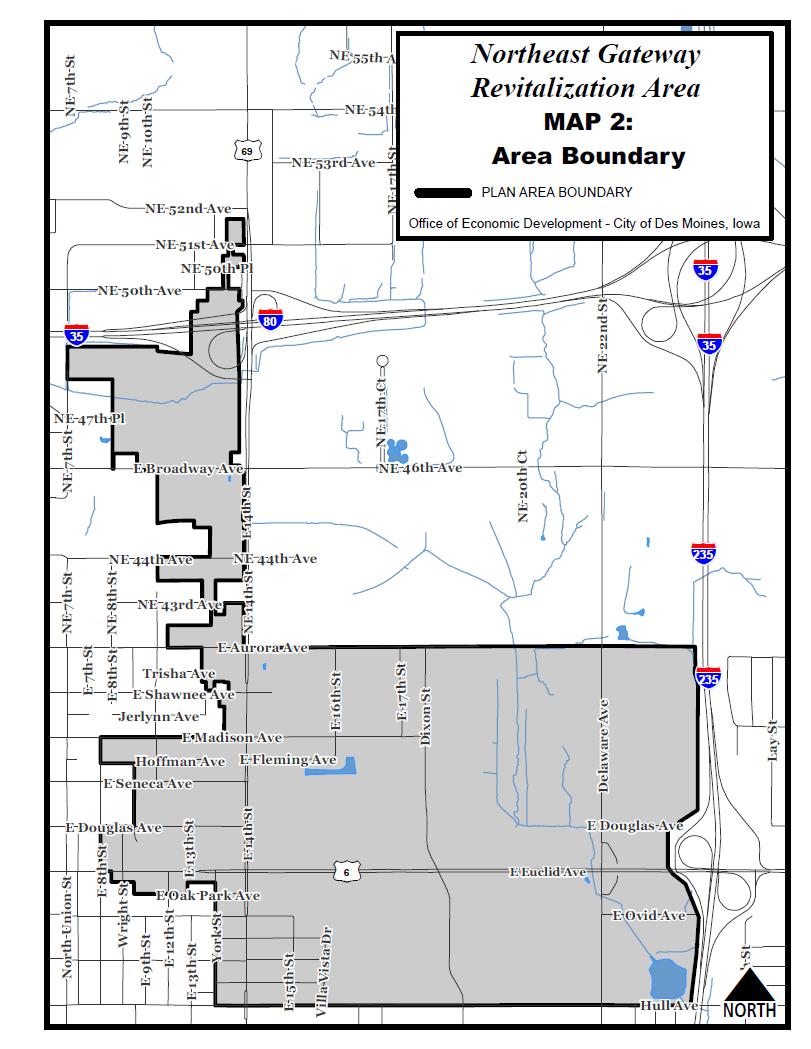
3 A. INTRODUCTION 1.) Description of the Northeast Gateway Revitalization Area The Northeast Gateway Revitalization Area contains approximately acres, and has an irregular boundary that extends north to NE 52nd Avenue, east to Interstate 235, south to Hull Avenue, and west to E 7th Street, as shown on Map 1, "Vicinity of the Area", Map 2, Area Boundary, and as more specifically described in Attachment A, "Legal Description". 2.) Purpose of this Plan The Northeast Gateway Revitalization Plan (this Plan ) is intended to guide the development of and stimulate private economic investment activities within the Northeast Gateway Revitalization Area (the Area ) through the provision of infrastructure improvements and economic development financial assistance that is provided, in part, with the tax increment revenues generated by the urban renewal areas established within the Area. This Plan is also intended to respond to and identify the necessary tools to remedy the conditions of blight existing in the Area. The location of the Area in northeast Des Moines, adjacent to two major arterial streets (E. 14 th Street and E. Euclid Avenue) and its proximity to the interstate system provide opportunities for high visibility and new investment. The age and condition of portions of the real estate in the Area, as well as blighted vacant buildings and sites, prompts the need for revitalization. The City of Des Moines believes that the designation of the Area as two separate urban renewal areas, known as Northeast Gateway 1 and Northeast Gateway 2, and the adoption and implementation of this Plan within those urban renewal areas has the potential to strengthen and revitalize the local economy through: A. Providing for planned and unified development of high quality commercial, industrial, mixed use and residential uses and the physical and economic enhancement of the Area. B. Creation of a safe and attractive physical environment through the construction and installation of necessary infrastructure and other public improvements or projects supportive of the Area. C. Retention and creation of quality permanent employment opportunities for residents. D. Expansion of the property tax base of the Area, and subsequently contributing to the economic betterment of the entire City of Des Moines. E. Creation of financial incentives as necessary to encourage new and existing businesses to invest and expand in the Area. B. BACKGROUND INFORMATION 3
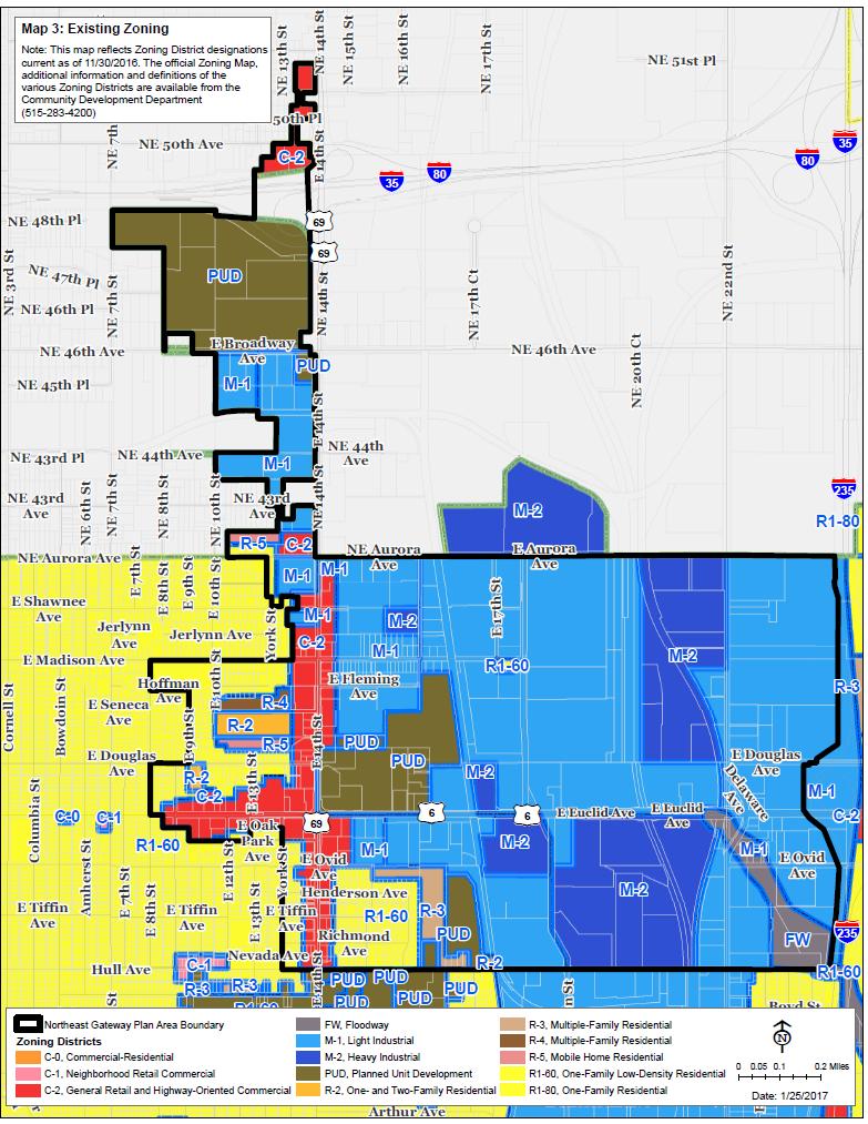
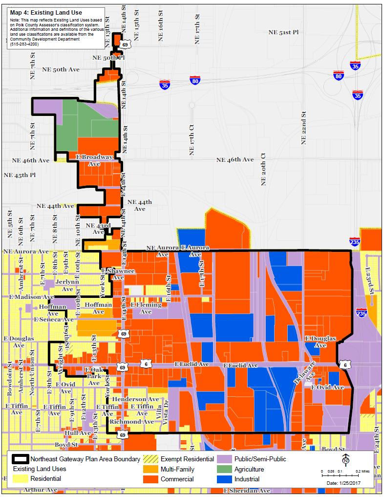
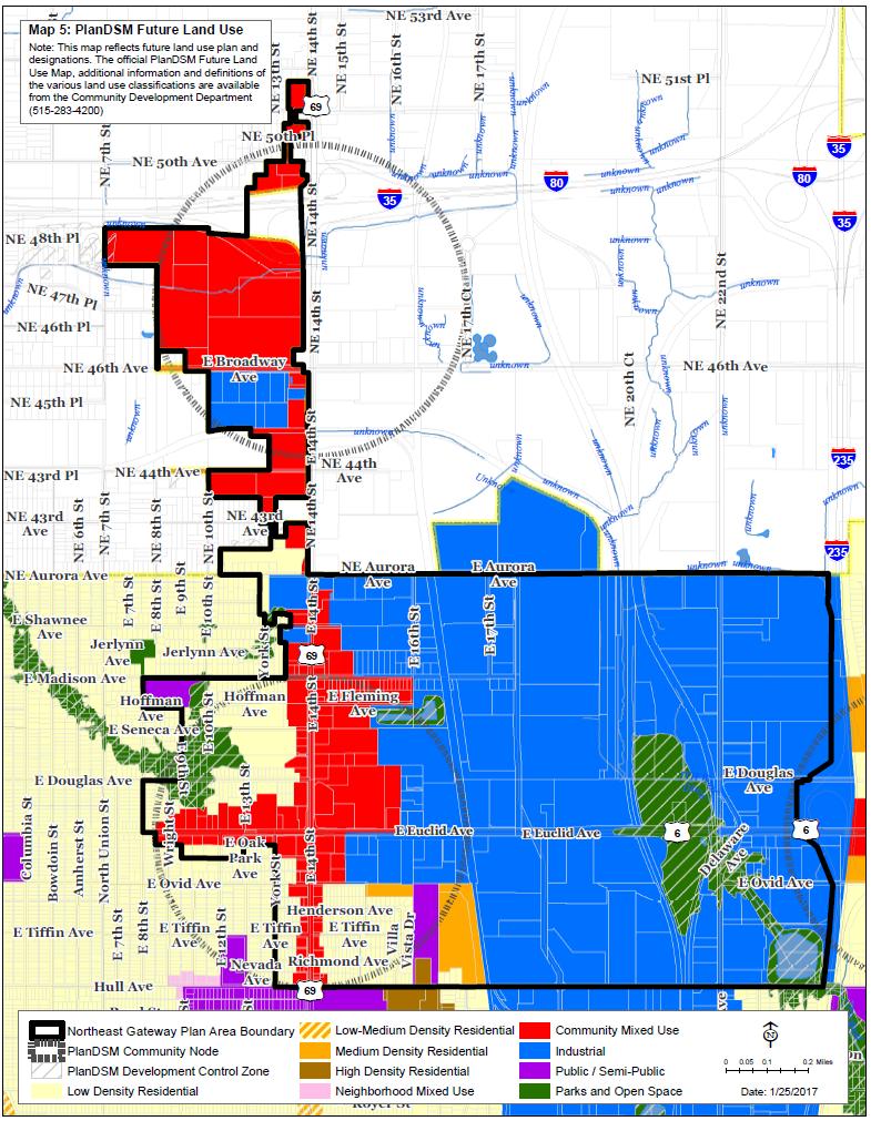
4 1.) General Information The Northeast Gateway Revitalization Area is comprised of a combination of elements that have built out over decades. Along E. 14 th Street and E. Euclid Avenue, there are commercial and industrial buildings and vacant sites, with buildings that were constructed in the 1950 s. South of E. Madison and west of Dixon Street there are industrial buildings that have experienced a varied level of rehabilitation and new investment and some are not suitable for modern business operations. The former Eastgate Shopping Center at the northeast corner of E. 14 th Street and E. Euclid Avenue has struggled to attract new investment since the former buildings were demolished over a decade ago. Regional retail competitiveness and limited trade share area has restricted this site and others within the Area from rising to the attention of the market. Scattered throughout the corridors are vacant lots and buildings and partially improved sites. Grand View University is located south of Hull Avenue at the southern end of the Area, and has significantly expanded its campus over the last decade, introducing an increased population seeking services and housing in the Area. The Area s location provides optimum visibility and transportation connectivity. E. 14 th Street carries an estimated 17,000 vehicles per day, serving as a corridor where commuters exit the interstate system and travel south into the Des Moines Central Business District. East Euclid Avenue carries an estimated 13,900 vehicles per day. Though the Area does provide some commercial services to northeast Des Moines neighborhoods, such as convenience stores, banks, restaurants, auto services and used-car sales lots, many service and employment needs are not met within the Area. This Plan is anticipated to provide an ability to acknowledge and work with the variety of conditions, existing uses and opportunities in the Area, providing a unity of purpose to create a thriving and cohesive area. 2.) Existing Land Use The Northeast Gateway Revitalization Area includes commercial, general industrial, multifamily residential, single family residential, and publicly owned uses. These uses are detailed in Map 4, "Existing Land Use". 3.) Proposed Land Use The City of Des Moines comprehensive plan: PlanDSM shows the land as a combination of low, medium and high density residential, community mixed use, industrial, and public/semi-public use. Map 5, "Future Land Use", identifies the proposed land uses for the area. This Plan does not contemplate any specific amendments to the comprehensive plan. Possible amendments to the comprehensive plan may be identified through the ongoing planning process for the implementation of this Plan. 4) Existing Zoning 4
5 The existing zoning within the Northeast Gateway Revitalization Area is identified in Map 3, "Existing Zoning". This Plan does not contemplate any specific amendments to the Zoning Ordinance. Possible amendments to the Zoning Ordinance may be identified though the ongoing planning process for the implementation of this Plan. 5.) Appropriateness for Economic Development E. 14 th Street, E. Euclid Avenue and the proximity to the interstate system provide high visibility and traffic counts that are conducive to commercial and industrial economic development activity. The Metropolitan Planning Organization s plan, known as Mobilizing Tomorrow, outlines a longrange transportation strategy for the year 2050 and a framework of how the MPO s member communities will invest approximately $600 million in transportation funding over the next 35 years with an emphasis on balancing growth to the east and north of the Des Moines metro area. Development of commercial and industrial businesses and services in the Northeast Gateway Revitalization Area is consistent with this planning vision. The vacant parcels along the E. 14 th Street and E. Euclid Avenue corridors offer potential opportunities for assembly and redevelopment, and the large tracts of land in the former Eastgate Plaza site and southwest of the E. 14th and Interstate 35/80 interchange offer opportunities for new development. For all these reasons the Area as a whole, and the separate portions of the Area located north and south of Aurora Avenue, are eligible for designation as urban renewal economic development areas appropriate for commercial and industrial enterprises. 6.) Recognition of Blight Conditions The Area as a whole, and the separate portions of the Area located north and south of Aurora Avenue, qualify as blighted areas due to existing conditions including vacant buildings and sites, buildings assessed at below normal and poor condition, warehouse buildings identified as economically obsolete, homeless camps, numerous buildings that are 50 years old or more, underutilized parcels, parcels that are not adequately sized for development without assemblage with other land, dilapidated buildings and buildings valued at less than the properties they are constructed on. All of these conditions have the impact of pulling down the economic viability of the Area, and create a need for revitalization. C. NORTHEAST GATEWAY REVITALIZTION PLAN ELEMENTS 1.) Goals and Objectives The primary goal for the Northeast Gateway Revitalization Plan is to guide the redevelopment of the Northeast Gateway Revitalization Area as a whole, and of the portions of the Area located north and south of Aurora Avenue, by setting objectives that will provide an ability for the Area to benefit from previous investments in public infrastructure and transportation systems, increase the tax base and retain and expand employment opportunities. Objectives for this Plan include: 5
6 A. Encourage and facilitate high quality commercial, industrial, mixed use and residential development within the Area. B. Coordination of resources to attract new quality economic development investment C Promote key public infrastructure projects in coordination with the private sector, Polk County, the Des Moines Wastewater Reclamation Authority, Des Moines Water Works and the Iowa Department of Transportation. These may include traffic signals at key intersections, access provision and management, and stormwater management improvements, as well as corridor beautification and signage at key nodes. D. Promote and coordinate additional land use and transportation system studies as warranted to ensure the ability to attract quality development and the ability to accommodate and manage traffic circulation. E. Encourage the use of low impact development and on-site stormwater management best practices in the Area, and coordinate the evaluation and assessment of natural resources proactively. F. Encourage the incorporation of long term sustainability into site development and building construction, particularly the efficient use of energy in lighting, heating, ventilation and cooling system design. 2.) Public Purpose Activities to be Undertaken To meet the objectives of this Plan, the City of Des Moines will support development and redevelopment of the Northeast Gateway Revitalization Area through, among other things, the following public purpose activities: A. Provision of technical support in furtherance of this Plan; B. Evaluation of property s potential for development and redevelopment purposes, including but not limited to activities such as appraisals and architectural, engineering and environmental studies; C. Acquisition and disposition of property for public improvements and for private development and redevelopment; D. Demolition and clearance of deteriorated, obsolescent and blighting structures and other improvements; E. Preparation of building sites for development and redevelopment purposes through activities that include but are not limited to grading, filling and landscaping; F. Improvement, installation, construction and reconstruction of streets, utilities, railroad spur lines and other public improvements and rights-of-way; G. Enforcement of applicable local, state and federal laws, codes and regulations; and H. Use of tax increment financing, loans, grants and other appropriate financial tools in support of eligible public and private development and redevelopment efforts. 6
7 All public purpose activities shall be conditioned upon and shall meet the restrictions and limitations placed upon the Area by this Plan. 3.) Land and Development Requirements The physical development of the Area will be regulated through the standards and guidelines contained within the City of Des Moines comprehensive plan: PlanDSM, the City of Des Moines Zoning Ordinance, the Des Moines Site Plan Regulations, and other applicable local, state and federal codes and ordinances. In addition, all projects within a designated urban renewal area that are requesting financial assistance through tax increment financing must undergo review by the Urban Design Review Board. The criteria to be used by the Board for making recommendations on design shall include but are not limited to: Scale, proportion, color, articulation, massing, patterning, setbacks and exterior materials. Permanence and quality of materials and site design, as well as details that add character and define depth are desired. How the project promotes an attractive and appealing physical environment. Encourage the incorporation of long term sustainability into site development and building construction, particularly the efficient use of materials and energy in heating, ventilation and cooling system design. Encourage the use of low impact development and on-site stormwater management best practices in the Area, and coordinate the evaluation and assessment of natural resources proactively. D. NORTHEAST GATEWAY REVITALIZTION PLAN IMPLEMENTATION The City of Des Moines will take necessary action to achieve the goals and objectives of the Northeast Gateway Revitalization Plan. This will include involvement in the following activities: 1.) Continued Planning Efforts The City shall continue to evaluate the needs of the Area, identifying issues and coordinating a response to these issues. A comprehensive approach will be taken to gathering input from landowners, neighborhoods, businesses and development interests. The City shall consider the adoption of separate urban renewal plans within the Area utilizing tax increment financing to provide additional legal and financial tools for the implementation of this Plan. One urban renewal area is proposed to be located entirely within the Saydel Community School District, and a separate urban renewal area is proposed to be located entirely within the Des Moines Independent School District to avoid the transfer of tax increment revenues between the two school districts. 2.) Technical Assistance 7
8 The City may provide technical assistance to landowners and prospective developers where appropriate. The City will work to coordinate efforts related to development proposals, ongoing planning, coordination with other agencies and levels of government, and other activities that will assist with meeting the objectives of this Plan. 3.) Funding and Financing: Economic Development Assistance The City will pursue funding sources required to meet the objectives of this Plan. Sources may include, but are not limited to, loans, grants, general fund expenditures, tax abatement, urban renewal tax increment financing, special assessments, bond issuance, and participation in state/federal programs. More specifically, the use of urban renewal tax increment financing and the review steps and requirements for proposed economic development assistance are specified as follows: Tax Increment Financing. The City believes that the use of tax increment revenues to assist in the financing of new development or redevelopment in the Northeast Gateway Revitalization Area is necessary in the public interest to achieve the objectives of this Plan. Without the use of this special financing tool, new investment may not otherwise occur or may occur at within other jurisdictions. The use of tax increment financing to spur the development of the Area pursuant to this Plan is expected to provide greater future property tax revenues for the City, Polk County, Saydel Community School District and Des Moines Independent School District, than would otherwise be available if this Plan were not implemented. Tax increment financing will be used only where it is anticipated to provide a long-term payback in overall increased tax base for the City, County and School Districts. The initial public investment required to generate new private investment is anticipated to ultimately increase the taxable value of the Area beyond its existing base value. Tax increment reimbursement may be sought for, among other things, the following costs to the extent they are incurred by the City for projects and activities within a designated urban renewal area: a. Planning and administration of the individual urban renewal plans within the Area; b. Construction of public infrastructure improvements and facilities within the Area; c. Acquisition, installation, maintenance and replacement of public investments throughout the Area; d. Acquisition and disposal of property for public improvements and for private development and redevelopment. 8
9 e. The development or redevelopment of buildings or facilities within the Area to be occupied by qualifying entities; f. Loans or grants to qualified industries and businesses, including debt service payments on any bonds issued to finance such loans or grants, for purposes of expanding the business or activity, or other qualifying loan programs established in support of this Plan; and g. Providing the matching share for a variety of local, state and federal grants and loans. 4.) Public Improvements This Plan is an expression of the City's intent to promote the extension of public utilities (sanitary sewer, water, stormwater management systems, construction and rehabilitation of streets, green infrastructure and park amenities, provision for pedestrian access and connection to sidewalks and recreation trails, and corridor beautification, including landscape and hardscape elements) in the Area, and working with landowners and developers in accordance with the Statewide Urban Design Standards and Specifications (SUDAS) on uniform construction and installation of all public improvements in furtherance of the objectives of this Plan. Specific public improvements eligible for the receipt of funding from urban renewal tax increment financing will be identified in the urban renewal plan for the urban renewal area in which the improvements are located. 5.) Responsibility of Developers Developers shall work with the City to coordinate the realization of the intent of this Plan. This will include limiting exemption from taxes on the value added by the improvements where possible. It is recognized that when tax abatement is in place, it will reduce the amount of tax increment created by the Area. Therefore in certain cases it may be necessary for developers to forego tax abatement to make a project work. The City reserves the ability to negotiate what will be in the best interest of the community and the furtherance of this Plan, while working with developers to facilitate new projects. 6.) Activities Under Chapter 15A The City may as part of its action to carry out this Plan engage in economic development activities within the Northeast Gateway Revitalization Area pursuant to Iowa Code Chapter 15A for the creation of new jobs and income, and for the retention of existing jobs and income that would otherwise be lost, when such economic development activities are found by the City Council to further the objectives of this Plan. The City may solicit and or package such economic development activity proposals in the form of direct financial assistance through grants or loans. Specific activities and projects eligible for the receipt of funding from urban renewal tax increment financing will be identified in the urban renewal plan for the urban renewal area in which the activities and projects are located. 9
10 E. DURATION AND AMENDMENT OF THE PLAN This Plan shall continue in effect until terminated by the City Council, but may be amended from time to time as the City Council determines to be appropriate. No amendment of this Plan shall be applicable to any urban renewal plan which adopts all or any portion of this Plan by reference, until such urban renewal plan is amended in conformance with the Iowa Urban Renewal Law to adopt this Plan as so amended. F. ATTACHMENTS A - Legal Description of Area Map 1: Vicinity of the Area Map 2: Area Boundary Map 3: Existing Zoning Map 4: Existing Land Use Map 5: Future Land Use 10
11 Attachment A - Legal Description Northeast Gateway Revitalization Area Proposed Northeast Gateway Revitalization Plan Boundary Description: Beginning at the intersection of the centerline of Hull Avenue and the centerline of Dixon Street; Thence West along the centerline of Hull Avenue to the centerline of York Street; Thence North along the centerline of York Street to the Easterly extension of the South line of Lot 59, Mann s 2 nd Addition to Highland Park, an Official Plat; Thence West along said Easterly Extension and the South line of said Lot 59 to the Southwest corner of said Lot 59; Thence continuing West along the South line of Lots 52 through 58 of said Mann s 2 nd Addition to Highland Park to the Southwest corner of said Lot 52; Thence South along the Southerly extension of West line of said Lot 52 to the centerline of Oak Park Avenue; Thence West along the centerline of Oak Park Avenue to the centerline of East 12 th Street; Thence North along the centerline of East 12 th Street to the Easterly Extension of the South line of Lot 7, Timmins Subdivision, an Official Plat; Thence West along said Easterly Extension and the South line of said Lot 7 to the Southeast corner of Lot 9, Rocky Place, an Official Plat; Thence continuing West along the South line of said Lot 9 to the Southwest corner of said Lot 9; Thence North along the West line of said Lot 9 to the Easterly Extension of the South line of Lot 140, Campus Park, an Official Plat; Thence West along said Easterly Extension and South line of said Lot 140 to the Southwest corner of said Lot 140; Thence continuing West along a straight line to the Southeast corner of Lot 111 of said Campus Park; Thence West along the South line of said Lot 111 to the Southwest corner of said Lot 111; Thence North along the West line of Lots 111, 112, 113 of said Campus Park, and the Northerly extension of the West line of said Lot 113 to the centerline of East Euclid Avenue; Thence West along the centerline of East Euclid Avenue to the centerline of East 8 th Street; Thence North along the centerline of East 8 th Street to the centerline of East Douglas Avenue; Thence East along the centerline of East Douglas Avenue to the centerline of East 9 th Street; Thence North along the centerline of East 9 th Street to the centerline of Hoffman Avenue; Thence West along the centerline of Hoffman Avenue to the centerline of East 8 th Street; Thence North along the centerline of East 8 th Street to the centerline of East Madison Avenue; Thence East along the centerline of East Madison Avenue to the Southerly Extension of the East Line of Lot 44, Shawnee Acres, an Official Plat; Thence North along said Southerly Extension and the East line of said Lot 44 to a line that is feet North of and parallel with the South line of said Lot 44; Thence West along said parallel line to West line of said Lot 44; Thence North along said West line and its Northerly Extension to the centerline of East Shawnee Avenue; Thence East along the centerline of East Shawnee Avenue to the Southerly Extension of the East line of the West 65 feet of Lots 32 and 33 of said Shawnee Acres; Thence North along said Southerly Extension and said East line of the West 65 feet of Lots 32 and 33 to the North line of said Lot 32; Thence West along said North line to the East line of Lot 23 of said Shawnee Acres; Thence North along said East line to a line that is feet North of and parallel to the South line of Lots 21, 22 and 23 of said Shawnee Acres; Thence West along said parallel line to a line that is 8 feet West of and parallel to the East line of said Lot 21; Thence South along said parallel line to the South line of said Lot 21; Thence West along said South line and continuing along the South line of Lots 19 and 20 of said Shawnee Acres to a line that is 65 feet East of and parallel to the West line of said Lot 19; Thence North along said parallel line to a line that is feet North of and parallel to the South line of said Lot 19; Thence West along said parallel line to line that is 1 foot East of and parallel with the West Line of said Lot 19; Thence North along said line that is 1 foot East of and parallel with the West Line 11
12 of said Lot 19 to a line that is feet North of and parallel with the South Line of said Lot 19; Thence West along said line that is feet North of and parallel with the South Line of said Lot 19 to the West line of said Lot 19; Thence North along said West line and its Northerly Extension to the centerline of East Aurora Avenue Right of Way; Thence West along said centerline to the Southerly Extension of the West line of Lot 11, Pagliai Place, an Official Plat; Thence North to the Southwest corner of said Lot 11; Thence continuing North along the West line of Lot 11 and Lot 16 of said Pagliai Place to the Northwest corner of said Lot 16; Thence East along the North line of said Lot 16 to the Southwest corner of Lot 48, Iowa Garden Acres, an Official Plat; Thence North along the West line of said Lot 48 to the Northwest corner of said Lot 48; Thence continuing North along the Northerly Extension of the West line of said Lot 48, a distance of 15.0 feet to the centerline of Northeast 43 rd Avenue Right of Way; Thence West along said centerline to the Southerly Extension of the West line of Lot 1 in said Iowa Garden Acres; Thence North along said Southerly Extension and along said West line to the Northwest corner of said Lot 1; Thence West along the South line of the North quarter (1/4) of the Southeast Quarter (1/4) of the Northeast Quarter (1/4) of said Section 23, to the West line of the Southeast Quarter (1/4) of the Northeast Quarter (1/4) of said Section 23; Thence North along the West line of the Southeast Quarter (1/4) of the Northeast Quarter (1/4) of said Section 23, to the North right of way line of Northeast 44th Avenue (Hoffman Road); Thence East along said North right of way line to the Southerly Extension of the East line of Lot 21, Stickler Heights, an Official Plat; Thence North along the East line of said Lot 21 to the Northeast corner of said Lot 21; Thence West along the North line of said Lot 21, to a point feet West of the East line of the Northeast Quarter (1/4) of the Northeast Quarter (1/4) of said Section 23; Thence North along a line that is feet West of and Parallel with said East line of the Northeast Quarter (1/4) of the Northeast Quarter (1/4) of Section 23 to the South line of Vista Broadway Industrial Plat 1, an Official Plat; Thence West along said South line to the West line of said Vista Broadway Industrial Plat 1; Thence North along said West line to the South Right of Way line of Northeast 46th Avenue (East Broadway Avenue); Thence West along said South Right of Way line to a point that is 300 feet West of the East line of the Southwest Quarter (1/4) of the Southeast Quarter (1/4) of Section 14, Township 79 North, Range 24 West of the 5 th P.M.; Thence North along a line that is 300 feet West of and parallel to the East line of the Southwest Quarter (1/4) of the Southeast Quarter (1/4) of said Section 14, to the North right of way line of Northeast 46th Avenue (East Broadway Avenue); Thence North West, feet; Thence South West, feet; Thence South East, feet to the centerline of Northeast 46th Avenue Right of Way (East Broadway Avenue); Thence South West along said centerline, a distance of feet to the West line of the East ½ of the Southwest Quarter (1/4) of the Southeast Quarter (1/4) of said Section 14; Thence North along said West line, a distance of 33 feet; Thence North West along said West line, feet to the North line of the Southwest Quarter (1/4) of the Southeast Quarter (1/4) of said Section 14; Thence South West along said North line, feet to the Northwest corner of the Southwest Quarter (1/4) of the Southeast Quarter (1/4) of said Section 14; Thence North East along the West line of the Southeast Quarter (1/4) of said Section 14, a distance of feet to a point that is feet South of the centerline of US Interstate 80/35 Right of Way, as it is presently established; Thence North East, parallel with and feet South of the South line of the North ½ of the Northwest Quarter (1/4) of the Southeast Quarter (1/4) of said Section 14, a distance of feet to the East line of the Northwest Quarter (1/4) of the Southeast Quarter (1/4) of said Section 14; Thence South East, feet along the East line of the Northwest Quarter (1/4) of the Southeast Quarter (1/4) of said Section 14; Thence South East, feet; Thence North
13 West, feet to the present North Right of Way line of US Interstate 80/35; Thence continuing North West, feet; Thence North East, feet; Thence North West, feet; Thence North East, feet; Thence North West, feet to the centerline of Northeast 50th Avenue Right of Way (Goode Drive); Thence East along said centerline to the Southerly Extension of the West line of Lot 19, Goode Heights Plat One, an Official Plat; Thence North along the Southerly Extension of the West line of said Lot 19 to the Southwest corner of said Lot 19,; Thence North along the West line of said Lot 19 and the West line of Lot 17, of said Goode Heights Plat One, to the Northwest corner of said Lot 17, and the South Right of Way line of Lot D, Goode Heights Plat One, (also known as Wauneta Drive and Northeast 50th Place); Thence continuing North along the Northerly Extension of said Lot 17 to the North Right of Way line of said Lot D, (Wauneta Avenue and Northeast 50th Place) and the Southwest corner of Lot 2 of said Goode Heights Plat One; Thence North along the West line of said Lot 2 to the Northwest corner of said Lot 2; Thence East along the North line of said Lot 2 to the Northeast corner of said Lot 2, also being the Southwest corner of Lot 27, Goode Heights Plat No.2, an Official Plat; Thence North along the West line of said Lot 27 to the Northwest corner of said Lot 27 and the South Right of Way line of Lot A, (also known as Forrest Goode Road and Northeast 51st Avenue) of said Goode Heights Plat No.2; Thence North along the Northerly Extension of the West line of said Lot 27 to the North Right of Way line of Northeast 51 st Avenue (Forrest Goode Road); Thence West along said North Right of Way line to the Southwest corner of Lot 14 of Pettit Place, an Official Plat; Thence North along the West line of said Lot 14, a distance of feet; Thence East along a line feet North of and parallel with the South line of said Lot 14, a distance of feet to the East line of said Lot 14; Thence South along the East line of said Lot 14, a distance of feet to the South line of said Lot 14 to the North Right of Way line of said Northeast 51 st Avenue (Forrest Goode Road); Thence continuing South along the Southerly Extension of the East line of said Lot 14 to the centerline of said Northeast 51 st Avenue Right of Way (Forrest Goode Road); Thence West along the centerline of said Northeast 51 st Avenue Right of Way (Forrest Goode Road), said centerline also being the North line of Lot A of said Goode Heights Plat No.2, to a point that is 150 feet West of the East line of said Lot A; Thence South along a line that is 150 feet West of and parallel to the East line of said Lot 27, to a line that is 120 feet South of and parallel to the North line of said Lot 27; Thence East along said parallel line to the East line of said Lot 27; Thence South along said East line to the North line of Lot 1 of said Goode Heights Plat One; Thence East along the North line of said Lot 1, a distance of 10.0 feet to the Northeast corner of said Lot 1; Thence South along the East line of said Lot 1, to the Southeast corner of said Lot 1, said corner also being the Northeast corner of Lot D (Wauneta Avenue and Northeast 50th Place) in said Goode Heights Plat One; Thence West along the North line of said Lot D, (Wauneta Avenue and Northeast 50th Place), a distance of 60 feet; Thence South along a line that 60 feet West of and parallel with the East line of said Lot D, for a distance of 25 feet; Thence West along a line that is 25 feet South of and parallel with the North line of said Lot D to the Northerly Extension of Lot 17 in said Goode Heights Plat One; Thence South along said Northerly Extension of the East line of said Lot 17 and along the East line of Lots 17 and 19 of said Goode Heights Plat One, feet, to the North line of Lot A (also known as Northeast 50th Avenue and Goode Drive) of said Goode Heights Plat 1, to a point feet West of the East line of said Lot A; Thence East along said North line of Lot A to a point that is feet West of the East line of said Section 14; Thence South along a line that is feet West of and parallel with the East line of said Section 14 to the South Right of Way line of Northeast 50th Avenue (Goode Drive), and being on the West Right of Way line of Northeast 14th Street (U.S. Highway 69); Thence South West, feet along said Right of Way line; Thence 13
14 South East along said Right of Way line, a distance of 60.0 feet; Thence South East along said Right of Way line, a distance of feet; Thence South West, feet to the North Right of Way line of United States Interstate 35-80; Thence South along a straight line to a point that is 116 feet West of the East line of the Southeast Quarter (1/4) of said Section 14 and feet North of the South line of the Southeast Quarter (1/4) of said Section 14; Thence South East, parallel with and feet West of the East line of the Southeast Quarter (1/4) of said Section 14, a distance of feet; Thence South West, feet; Thence South East, feet to a point 50.0 feet North of the South line of the Southeast Quarter (1/4) of said Section 14; Thence East along a line that is 50.0 feet North of and parallel with the South line of said Section 14, a distance of feet; Thence South feet to a point 52.0 feet South of the North line of Section 23, Township 79 North, Range 24 West of the 5th P.M. and feet West of the East line of said Section 23; Thence East along the South Right of Way line of Northeast 46th Avenue (East Broadway Avenue) to the West Right of Way line of Northeast 14th Street (U.S. Highway 69), said Right of Way line being 50.0 feet West of the East line of said Section 23; Thence South along the West Right of Way line of said Northeast 14th Street (U.S. Highway 69), to the North line of Lot 1, Iowa Garden Acres, an Official Plat; Thence West along said North line of said Lot 1, to a point feet East of the Northwest corner of said Lot 1; Thence South along a line that is feet East of and parallel with the West line of said Lot 1, to the South line of said Lot 1; Thence continuing South along the Southerly Extension of said parallel line to the centerline of Northeast 43rd Avenue, a distance of 15.0 feet; Thence West along said centerline to the Northerly Extension of the West line of Lot 49 of said Iowa Garden Acres; Thence South along said Northerly Extension and along said West Line to a Line that is feet North of and parallel with the South Line of Lots 49 and 50 of said Iowa Garden Acres; Thence East along said line that is feet North of and parallel with the South line of Lots 49 and 50 of said Iowa Garden Acres to the West line of Lot 51 of said Iowa Garden Acres; Thence North along the West line of said Lot 51, to the Northwest corner of said Lot 51; Thence continuing North along the Northerly Extension of said West line to the centerline of Northeast 43rd Avenue Right of Way, a distance of 15.0 feet; Thence East along the centerline of Northeast 43rd Avenue and parallel with the North line of Lots 51 and 52 of said Iowa Garden Acres, to the West Right of Way line of Northeast 14th Street (U.S. Highway 69); said point being 50.0 feet West of the East line of said Section 23; Thence South along a line that is 50.0 West of and parallel to said East line of said Section 23, to the centerline of East Aurora Avenue Right of Way; Thence East along the centerline of East Aurora Avenue to the West Right of Way line US Interstate 235; Thence South along said West Right of Way line to the centerline of Hull Avenue; Thence West along said centerline of Hull Avenue to the Point of Beginning. 14
15 15
16 16
17 17
18 18
19 19
EXHIBIT A. Tax Increment Reinvestment Zone No. 1 (Town Center) First Amended Project Plan 1
 First Amended Project Plan 1") EXHIBIT A Tax Increment Reinvestment Zone No. 1 (Town Center) First Amended Project Plan 1 1 As amended by Resolution No. 2008-02-001(TR1R) of the Tax Increment Reinvestment Zone No.1, and approved to
EXHIBIT A Tax Increment Reinvestment Zone No. 1 (Town Center) First Amended Project Plan 1 1 As amended by Resolution No. 2008-02-001(TR1R) of the Tax Increment Reinvestment Zone No.1, and approved to
Planning Districts INTRODUCTION
 INTRODUCTION To facilitate detailed examination of development prospects for all areas of the community, Delano has been divided into 14 planning districts. The location of these planning districts is
SOUTH MAIN RIVER COMMUNITY REINVESTMENT PROJECT AREA PLAN DATED AUGUST 31, 2018
 SOUTH MAIN RIVER COMMUNITY REINVESTMENT PROJECT AREA PLAN DATED AUGUST 31, 2018 Redevelopment Agency of the City of Logan, Utah South Main River Community Reinvestment Project Area - 1 - INTRODUCTION 1.
CHAPTER 12 IMPLEMENTATION
 CHAPTER 12 IMPLEMENTATION The 2010 Town of Denton Comprehensive Plan is intended to capture a vision of the future of Denton. As such, it provides a basis for a wide variety of public and private actions
Metro Center. Urban Renewal Project
 Restated Urban Renewal Plan for the Metro Center Urban Renewal Project Des Moines, Ia. [Up to and including the 12 th Amendment] Approved by City Council Resolution No. 13-- on. 2013 Metro Center Urban
CITY OF HERMISTON DOWNTOWN URBAN RENEWAL PLAN
 CITY OF HERMISTON DOWNTOWN URBAN RENEWAL PLAN AUGUST 2013 Prepared For: CITY OF HERMISTON, OREGON By: JOHNSON REID, LLC STIVEN PLANNING & DEVELOPMENT SERVICES, LLC TABLE OF CONTENTS I. Introduction...
TEMPLE MEDICAL & EDUCATION DISTRICT
 City of Temple, Texas TEMPLE MEDICAL & EDUCATION DISTRICT 1 Description. The City of Temple joined in partnership with key public and private entities to jointly promote education and medical activities
The transportation system in a community is an
 7 TRANSPORTATION The transportation system in a community is an important factor contributing to the quality of life of the residents. Without a sound transportation system to bring both goods and patrons
RESOLUTION NO. WHEREAS, the City of Riverdale (the City ) has a planning commission and has adopted a general plan pursuant to applicable law; and
 has a planning commission and has adopted a general plan pursuant to applicable law; and") RESOLUTION NO. RESOLUTION OF THE REDEVELOPMENT AGENCY OF RIVERDALE CITY ADOPTING AN OFFICIAL PROJECT AREA PLAN FOR THE 700 WEST COMMUNITY DEVELOPMENT PROJECT AREA. WHEREAS, the Redevelopment Agency of
RESOLUTION NO. RESOLUTION OF THE REDEVELOPMENT AGENCY OF RIVERDALE CITY ADOPTING AN OFFICIAL PROJECT AREA PLAN FOR THE 700 WEST COMMUNITY DEVELOPMENT PROJECT AREA. WHEREAS, the Redevelopment Agency of
VILLAGER SQUARE URBAN RENEWAL PLAN
 VILLAGER SQUARE URBAN RENEWAL PLAN City of Broomfield August 21, 1997 1 Table of Contents Villager Square Urban Renewal Project Urban Renewal Plan A. PREFACE 1 B, URBAN RENEWAL AREA BOUNDARIES 1 C. SUMMARY
Gold Line Bus Rapid Transit Transit Oriented Development (BRTOD) Helmo Station Area Plan
 Helmo Station Area Plan") Appendix F Gold Line Bus Rapid Transit Transit Oriented Development (BRTOD) Helmo Station Area Plan Introduction and Purpose of the Plan The Gold Line Bus Rapid Transit facility is an eleven-mile dedicated
Appendix F Gold Line Bus Rapid Transit Transit Oriented Development (BRTOD) Helmo Station Area Plan Introduction and Purpose of the Plan The Gold Line Bus Rapid Transit facility is an eleven-mile dedicated
C. Westerly Creek Village & The Montview Corridor
 C. Westerly Creek Village & The VISION Community Vision When the goals of the city are achieved Westerly Creek Village, a distinctive community defined by Montview Boulevard and Westerly Creek, is a strong
CITY OF COLWICH COMPREHENSIVE PLAN LAND USE LAND USE 1
 LAND USE LAND USE 1 WHAT YOU WILL FIND IN THIS CHAPTER: Discussion of today s conditions and tomorrow s projections Discussion of challenges and opportunities Discussion of the environmental quality goals,
5 TOWN OF MARKHAM OFFICIAL PLAN AMENDMENT NO. 144 MILLIKEN MAIN STREET SECONDARY PLAN
 5 TOWN OF MARKHAM OFFICIAL PLAN AMENDMENT NO. 144 MILLIKEN MAIN STREET SECONDARY PLAN The Planning and Economic Development Committee recommends the following: 1. The communication from Brendan O Callaghan,
Woodburn Comprehensive Plan Growth Management Goals and Policies
 Goal Woodburn Comprehensive Plan Growth Management Goals and Policies G-1. The City's goal is to manage growth in a balanced, orderly and efficient manner, consistent with the City s coordinated population
Illustration of Eastlake Farmer s Cooperative Grain Elevator. Chapter 5: implementation 5-1
 Illustration of Eastlake Farmer s Cooperative Grain Elevator Chapter 5: implementation 5-1 chapter 5: implementation Introduction The Eastlake Subarea Plan includes a wide range of recommendations intended
Chapter 1: Introduction
 Chapter 1: Introduction The Penn Avenue Community Works Corridor Vision and Implementation Framework presents an integrated communitybased vision and a coordinated, long-term implementation framework for
Albert Lea. Redevelopment Plan. 701 Xenia Avenue South, Suite 300 Minneapolis, MN Tel: (763) Fax: (763) wsbeng.
 Fax: (763) wsbeng.") Albert Lea Redevelopment Plan 701 Xenia Avenue South, Suite 300 Minneapolis, MN 55416 Tel: (763) 541-4800 Fax: (763) 541-1700 wsbeng.com Albert Lea Redevelopment Plan Table of Contents Composite Districts...
Albert Lea Redevelopment Plan 701 Xenia Avenue South, Suite 300 Minneapolis, MN 55416 Tel: (763) 541-4800 Fax: (763) 541-1700 wsbeng.com Albert Lea Redevelopment Plan Table of Contents Composite Districts...
ARTICLE VII OVERLAY DISTRICTS AND AREAS
 ARTICLE VII OVERLAY DISTRICTS Section 7.1 Special Overlay Districts Special Overlay Districts may be created by the City of Mascotte to facilitate unique development activities where there is need for
FUTURE LAND USE ELEMENT
 FUTURE LAND USE ELEMENT GOAL I: To create and sustain a great place to live, play, and prosper Objective 1: The City of Ocala shall incorporate the principles and strategies of the Ocala 2035 Vision into
Employment and Commercial Review Analysis of Policy Directions
 Employment and Commercial Review Analysis of Policy Directions Appendix A The following analysis is town staff s response to the policy directions provided by the consultants who prepared the Employment
9 CITY OF VAUGHAN OFFICIAL PLAN AMENDMENT NO BOCA EAST INVESTMENTS LIMITED
 9 CITY OF VAUGHAN OFFICIAL PLAN AMENDMENT NO. 631 - BOCA EAST INVESTMENTS LIMITED The Planning and Economic Development Committee recommends the adoption of the recommendations contained in the following
EAST LAKE TARPON COMMUNITY OVERLAY
 EAST LAKE TARPON COMMUNITY OVERLAY East Lake Tarpon in Pinellas County Florida physical area is defined by the boundaries of the as shown in the map below and legal description in Appendix A. VISION: East
REQUEST FOR QUALIFICATIONS
 REQUEST FOR QUALIFICATIONS VILLAGE OF HAMBURG COMPREHENSIVE ZONING/LAND USE REGULATIONS UPDATE Prepared By: Village of Hamburg 100 Main Street Hamburg, New York 14075 Village of Hamburg RFQ Page 1 of 10
The Five Components of the McLoughlin Area Plan
 The Five Components of the McLoughlin Area Plan This documents contains the complete language of the five components of the McLoughlin Area Plan: The Vision Statement The Values The Guiding Principles
6 Growth Management Challenges and Opportunities
 6 Growth Management Challenges and Opportunities The Town has established a goal of attaining a 50% participation rate with respect to employment opportunities versus residential population. The Town s
WHEREAS, the current Comprehensive Plan was adopted in 2005; and
 RESOLUTION 2018-06 RESOLUTION TO AMEND THE CITY S COMPREHENSIVE PLAN TO (1) AMEND CHAPTER 4 TO ADD A SPECIAL REVITALIZATION DISTRICT FOR EDUCATION AND ECONOMIC DEVELOPMENT ; (2) DESIGNATE ON THE FUTURE
OFFICIAL CONTROLS IMPLEMENTATION LEGAL REQUIREMENTS
 IMPLEMENTATION The objective of the Implementation component of the Comprehensive Plan is to identify the changes that need to be made to the official controls in order to be consistent with the Comprehensive
CHAPTER 7: Transportation, Mobility and Circulation
 AGLE AREA COMMUNITY Plan CHAPTER 7 CHAPTER 7: Transportation, Mobility and Circulation Transportation, Mobility and Circulation The purpose of the Transportation, Mobility and Circulation Chapter is to
Cumberland Region Tomorrow is a private, non-profit, citizen based regional organization working with Greater Nashville Regional Council
 Cumberland Region Tomorrow is a private, non-profit, citizen based regional organization working with Greater Nashville Regional Council and others in the public and private sectors, dedicated to planning
13 THORNHILL YONGE STREET STUDY IMPLEMENTATION CITY OF VAUGHAN OPA 669 AND TOWN OF MARKHAM OPA 154
 13 THORNHILL YONGE STREET STUDY IMPLEMENTATION CITY OF VAUGHAN OPA 669 AND TOWN OF MARKHAM OPA 154 The Planning and Economic Development Committee recommends the adoption of the recommendations contained
17.11 Establishment of Land Use Districts
 17.11 Establishment of Land Use Districts 17.11.010 Purpose. To promote the health, safety, and general welfare of City residents and those who come to South Salt Lake to work, exchange commerce and recreate.
2 STATUTORY PUBLIC MEETING AND INFORMATION REPORT FOR PUBLIC MEETING ON AMENDMENT NO. 62 TO THE YORK REGION OFFICIAL PLAN
 2 STATUTORY PUBLIC MEETING AND INFORMATION REPORT FOR PUBLIC MEETING ON AMENDMENT NO. 62 TO THE YORK REGION OFFICIAL PLAN Pursuant to Section 17(15) of the Planning Act, as amended, the Regional Planning
Mark-up of the effect of the proposed Bronte Village Growth Area OPA No.18 on the text of section 24, Bronte Village, of the Livable Oakville Plan
 Mark-up of the effect of the proposed Bronte Village Growth Area OPA No.18 on the text of section 24, Bronte Village, of the Livable Oakville Plan Notes: This document is provided for information purposes
LIST OF PARTICIPANTS
 LIST OF PARTICIPANTS Planning Commission Jennifer Butler Dan Dorn Darr Goss Nathan Levin James Lewis Michael Nelson Jim Wiles City Council and Urban Renewal Agency Board of the City of Salem Janet Taylor
Staff Report and Recommendation
 Community Planning and Development Planning Services 201 W. Colfax Ave., Dept. 205 Denver, CO 80202 p: 720.865.2915 f: 720.865.3052 www.denvergov.org/cpd TO: City Council Neighborhoods and Planning Committee
EXISTING COMPREHENSIVE PLAN
 EXISTING COMPREHENSIVE PLAN Town Center Land Use Element: V. LAND USE POLICIES Town Center Mercer Island's business district vision as described in "Your Mercer Island Citizen-Designed Downtown" was an
Plan Policies. Introduction
 Plan Policies Introduction The purpose of the Plan Policies section is to identify the various Governing Body and Planning Commission land use related policy resolutions for use in evaluating development
The Corporation of the Town of Milton
 Report To: From: Council Barbara Koopmans, Commissioner, Planning and Development Date: May 7, 2018 Report No: Subject: Making it Possible Positioning the Town s Strategy for Growth and Economic Development
September 25th, 2018 $2000 fee pd CC
 2.7267 acres 2018I-00075 September 25th, 2018 $2000 fee pd CC Rezoning Review Criteria Analysis - Map Amendment Application Number: 2018I-00075 805 W. 38 th Avenue October 19, 2018 (amd.) September 17,
AMENDED AND RESTATED DEVELOPMENT PLAN FOR THE SPORTS FACILITY PROJECT WITHIN PLANNED DEVELOPMENT AREA NO. 87 BOSTON LANDING
 AMENDED AND RESTATED DEVELOPMENT PLAN FOR THE SPORTS FACILITY PROJECT WITHIN PLANNED DEVELOPMENT AREA NO. 87 BOSTON LANDING GUEST STREET, LIFE STREET AND ARTHUR STREET BRIGHTON AREA OF BOSTON DATED: August
Chapter Master Planned Communities (MPC) District
 District") Sections 14.53.010 Purpose and Intent 14.53.020 Applicability 14.53.030 Procedure 14.53.040 MPC Standards 14.53.050 Required Findings 14.53.010 Purpose and Intent Chapter 14.53 Master Planned Communities
Sections 14.53.010 Purpose and Intent 14.53.020 Applicability 14.53.030 Procedure 14.53.040 MPC Standards 14.53.050 Required Findings 14.53.010 Purpose and Intent Chapter 14.53 Master Planned Communities
12 AMENDMENT NO. 149, TOWN OF MARKHAM HIGHWAY 404 NORTH SECONDARY PLAN
 12 AMENDMENT NO. 149, TOWN OF MARKHAM HIGHWAY 404 NORTH SECONDARY PLAN The Planning and Economic Development Committee recommends the adoption of the recommendation contained in the following report August
Policies and Code Intent Sections Related to Town Center
 Policies and Code Intent Sections Related to Town Center The Town Center Vision is scattered throughout the Comprehensive Plan, development code and the 1994 Town Center Plan. What follows are sections
REZONING GUIDE. Zone Map Amendment (Rezoning) - Application. Rezoning Application Page 1 of 3. Return completed form to
 - Application. Rezoning Application Page 1 of 3. Return completed form to") Zone Map Amendment (Rezoning) - Application COMMUNITY PLANNING & DEVELOPMENT REZONING GUIDE Rezoning Application Page 1 of 3 PROPERTY OWNER INFORMATION* CHECK IF POINT OF CONTACT FOR APPLICATION Property
Zone Map Amendment (Rezoning) - Application COMMUNITY PLANNING & DEVELOPMENT REZONING GUIDE Rezoning Application Page 1 of 3 PROPERTY OWNER INFORMATION* CHECK IF POINT OF CONTACT FOR APPLICATION Property
REPORT OF THE PLANNING AND DEVELOPMENT DEPARTMENT FOR APPLICATION FOR REZONING ORDINANCE TO PLANNED UNIT DEVELOPMENT AUGUST 18, 2016
 REPORT OF THE PLANNING AND DEVELOPMENT DEPARTMENT FOR APPLICATION FOR REZONING ORDINANCE TO PLANNED UNIT DEVELOPMENT AUGUST 18, 2016 AWH The Planning and Development Department hereby forwards to the Planning
Red Fox Commercial Outline Plan
 Red Fox Commercial Outline Plan City of Cold Lake, Alberta Prepared by Durrance Projects Ltd and Ross W. Sharp & Associates Ltd October 2014 Rupert 1 Table of Contents 1. PURPOSE...3 1.1. Location...4
This page has been intentionally left blank.
 This page has been intentionally left blank. Chapter 3 3-2 3. Employment 3.A Niagara Economic Gateway 3.A.1 General The Niagara Economic Gateway comprises: a) The Gateway Economic Zone which includes all
Hockessin Community Redevelopment Plan
 Hockessin Community Redevelopment Plan 3.1 Introduction The Community Redevelopment Plan for the Village of Hockessin is the result of the people s vision for a distinct village center that serves as the
LOS ANGELES CITY PLANNING DEPARTMENT STAFF REPORT
 LOS ANGELES CITY PLANNING DEPARTMENT STAFF REPORT LOS ANGELES CITY PLANNING COMMISSION CASE NO: CPC 2006-9374 CRA CEQA: Exempt DATE: December 21, 2006 Location: Valley Plaza and Laurel Plaza TIME: after
Approved: CITY OF ARDEN HILLS, MINNESOTA PLANNING COMMISSION WEDNESDAY, AUGUST 5, :30 P.M. - ARDEN HILLS CITY HALL
 Approved: CITY OF ARDEN HILLS, MINNESOTA PLANNING COMMISSION WEDNESDAY, AUGUST 5, 2015 6:30 P.M. - ARDEN HILLS CITY HALL PLANNING CASES A. Planning Case 15-016; Final Planned Unit Development Arden Plaza;
CHAPTER 7: VISION AND ACTION STATEMENTS. Noble 2025 Vision Statement
 CHAPTER 7: VISION AND ACTION STATEMENTS This chapter presents the vision, policy and action statements that transform the comprehensive planning study, an analysis of Noble s past, future trends and community
1.0 Circulation Element
 5/9/18 1.0 Circulation Element 1.1 Introduction As growth and development occur in Apache County, enhancements to its circulation system will be necessary. With time, more roads will be paved and air and
REZONING GUIDE. Zone Map Amendment (Rezoning) - Application. Rezoning Application Page 1 of 3. Return completed form to
 - Application. Rezoning Application Page 1 of 3. Return completed form to") Zone Map Amendment (Rezoning) - Application COMMUNITY PLANNING & DEVELOPMENT REZONING GUIDE Rezoning Application Page 1 of 3 PROPERTY OWNER INFORMATION* CHECK IF POINT OF CONTACT FOR APPLICATION Property
Zone Map Amendment (Rezoning) - Application COMMUNITY PLANNING & DEVELOPMENT REZONING GUIDE Rezoning Application Page 1 of 3 PROPERTY OWNER INFORMATION* CHECK IF POINT OF CONTACT FOR APPLICATION Property
EXHIBIT B PROJECT NARRATIVE POULSBO MEADOWS
 EXHIBIT B PROJECT NARRATIVE POULSBO MEADOWS Name of Project: Poulsbo Meadows; A Planned Residential Development (PRD)/Plat Applicants Name: PBH Group LLC/Byron Harris PO Box 1010 Silverdale, WA 98038 Description
The Ingersoll Avenue Improvement Plan outlines an ambitious development and physical improvement program for
 THE INGERSOLL AVENUE IMPROVEMENT PLAN CHAPTER 5 IMPLEMENTATION The Ingersoll Avenue Improvement Plan outlines an ambitious development and physical improvement program for the corridor s future. This chapter
SECTION UNIFIED DEVELOPMENT ORDINANCE SECTION Part 1 Ordinance. ARTICLE 1 Zoning Districts
 SECTION 1-100 UNIFIED DEVELOPMENT ORDINANCE SECTION 1-300 Part 1 Ordinance SECTION 1-100. Introduction. ARTICLE 1 Zoning Districts Crystal Lake strives to maintain a balance of various land uses for a
Robbinsdale LRT Station. CDI Development Guidelines. August Overview
 Robbinsdale LRT Station August 2018 Overview The City of Robbinsdale may have the coolest opportunity site along the 13 mile stretch of the Bottineau LRT corridor / Blue Line extension. Located a block
PLANNED UNIT DEVELOPMENT & SUBDIVISION STAFF REPORT Date: May 18, 2017
 & PUD-0000102-2017 PLANNED UNIT DEVELOPMENT & SUBDIVISION STAFF REPORT Date: May 18, 2017 NAME SUBDIVISION NAME Dauphin Creek Estates Subdivision Dauphin Creek Estates Subdivision LOCATION CITY COUNCIL
Urban Design Brief December 23, 2015 Southside Construction Group Official Plan & Zoning By-Law Amendment
 Urban Design Brief Proposed Official Plan & Zoning By-Law Amendment 3244, 3263 and 3274 Wonderland Road South Southside Group December 23, 2015 TABLE OF CONTENTS Page No. INTRODUCTION... 1 SECTION 1 LAND
Joint Meeting City Council and the Plan Commission. September 1st, 2015
 Joint Meeting City Council and the Plan Commission September 1st, 2015 1 The City Plan Commission shall recommend a City Plan for the physical development of the City Article IX Section 2 of the City of
Strategic Growth Area #1 Northampton Boulevard Corridor Area
 Strategic Growth Area #1 Northampton Boulevard Corridor Area Description Strategic Growth Area #1 has established itself as a major employment center in Southside Hampton Roads. Opportunities exist to
TOP TEN LIST OF COMMUNITY CONCERNS REGARDING PROPOSED AMENDMENTS TO CHAPTER 42
 TOP TEN LIST OF COMMUNITY CONCERNS REGARDING PROPOSED AMENDMENTS TO CHAPTER 42 1. Extend the urban area to Beltway 8 in stages, over say a three-year period, prioritizing development in transit and declining
Table L-1 Summary Action Strategy. Action Item Timing Status Responsible Agency
 CHAPTER 4: CIRCULATION ELEMENT ISSUE #1: MAJOR THOROUFARES AND TRANSPORTATION ROUTES A balanced transportation system for Fontana is provided that meets the mobility needs of current and future residents
Economic Redevelopment of Underutilized Parcels. May 16, 2012 Northland Arboretum Brainerd, Minnesota
 Economic Redevelopment of Underutilized Parcels May 16, 2012 Northland Arboretum Brainerd, Minnesota Matt Glaesman City of St. Cloud Community Development Director 1. A Tradition of Change 2. Why Now?
WATERFORD Plan of Preservation, Conservation and Development Supplement Part 1 - Policy Element
 WATERFORD 2012 Plan of Preservation, Conservation and Development 2015 Supplement Part 1 - Policy Element Effective June 11, 2015 2015 Plan Update GOAL To respond to the evolving land use needs and continually
Madison St. Oak Park. Request for Proposals. Village Owned Parcel Madison Street Oak Park, Illinois Reissued May 25, 2018.
 Madison St. Oak Park Village Owned Parcel 700-728 Madison Street Oak Park, Illinois Reissued May 25, 2018 Proposal Due, 2018 Date 3:00 pm 700-728 Madison Street including adjacent public alley and street
Corridor Vision. 1Pursue Minnehaha-Hiawatha Community Works Project. Mission of Hennepin County Community Works Program
 1Pursue Minnehaha-Hiawatha Community Works Project Minnehaha-Hiawatha Community Works is a project within the Hennepin Community Works (HCW) program. The mission of the HCW program is to enhance how the
Bloor St. W. Rezoning - Preliminary Report
 STAFF REPORT ACTION REQUIRED 1638-1644 Bloor St. W. Rezoning - Preliminary Report Date: April 1, 2008 To: From: Wards: Reference Number: Toronto and East York Community Council Acting Director, Community
IMPLEMENTING SOMERSET COUNTY S INVESTMENT FRAMEWORK
 IMPLEMENTING SOMERSET COUNTY S INVESTMENT FRAMEWORK SMART CONSERVATION THROUGH SMART GROWTH NJ LAND CONSERVATION RALLY March 22, 2014 Laurette Kratina, PP, AICP, Supervising Planner Somerset County Planning
2018 Northampton Township Comprehensive Plan
 2018 BUCKS COUNTY, PENNSYLVANIA What is a? A comprehensive plan is a municipality s main policy document that details the collective vision for the future, the historic, environmental, and cultural facilities
QUEEN-RIVER SECONDARY PLAN
 34 QUEEN-RIVER SECONDARY PLAN 34. QUEEN RIVER SECONDARY PLAN 1. INTRODUCTION The Queen-River area is approximately 6.4 hectares and is located at the eastern edge of the Downtown as shown on Map 34-1.
PORTLAND DEVELOPMENT COMMISSION Portland, Oregon RESOLUTION NO APPROVING THE FOURTH AMENDMENT TO THE NORTH MACADAM URBAN RENEWAL PLAN
 PORTLAND DEVELOPMENT COMMISSION Portland, Oregon RESOLUTION NO. 7094 APPROVING THE FOURTH AMENDMENT TO THE NORTH MACADAM URBAN RENEWAL PLAN WHEREAS, the Portland City Council ( City Council ) adopted the
4 LAND USE DESIGNATIONS
 4 LAND USE DESIGNATIONS Chapter 4 describes the land use designations and densities that will implement the development vision for North Burlingame outlined in Chapter 3. Land use densities are described
Urban Renewal Proposal
 Urban Renewal Proposal South Nevada Avenue & South Tejon Street June 24, 2015 After Eight (8) years of exhaustive efforts by a number of local developers, the time has finally come for the City of Colorado
EXECUTIVE SUMMARY DRAFT CHAPTER 1 INTRODUCTION EXECUTIVE SUMMARY
 CHAPTER 1 EXECUTIVE SUMMARY INTRODUCTION Through the joint efforts of the City of Tulsa planning staff and the Land Services division of Indian Nations Council of Governments (INCOG), the Berryhill Land
Implementation Guide Comprehensive Plan City of Allen
 Implementation Guide 2030 Comprehensive Plan City of Allen DRAFT 2015 Implementation Guide Allen 2030 Comprehensive Plan INTRODUCTION The Comprehensive Plan serves as a guide for the growth and development
TOD 101 CREATING LIVABLE COMMUNITIES WITH TRANSIT
 1 CREATING LIVABLE COMMUNITIES WITH TRANSIT What are transit Centered Communities? Benefits of Partnerships to Support and Implement What You Will Learn Portland s Pearl District Your Trainers Today Catherine
Corridors. Re-vitalize our Corridors and Gateways
 Corridors Re-vitalize our Corridors and Gateways Artist s rendering from the 287 Strategic Plan, 2015 Corridors are the major throughways of Loveland but they also provide important commercial, community
Chapter 2: Vision, Goals and Strategies
 Chapter 2: Vision, Goals and Lake Elmo Today & Tomorrow Comprehensive Plan 2040 2 VISION, GOALS & STRATEGIES - DRAFT 4-6-2018 INTRODUCTION Comprehensive Plan Purpose Perhapse the most important objective
COUNTY COURT HOUSE REDEVELOPMENT AREA PLAN
 COUNTY COURT HOUSE REDEVELOPMENT AREA PLAN March 2005 CITY OF TRENTON DEPARTMENT OF HOUSING AND ECONOMIC DEVELOPMENT TABLE OF CONTENTS A. DESCRIPTION...3 1. BOUNDARIES OF PROJECT...3 2. REDEVELOPMENT PLAN
NEIGHBORHOOD DESIGN ELEMENT
 NEIGHBORHOOD DESIGN ELEMENT INTRODUCTION The following recommendations constitute an urban design oriented "neighborhood analysis" of Plantation. It is an optional Comprehensive Plan Element. The five
Development Solicitation Request for Qualifications. The Historic Hollering Place Development
 City of Coos Bay Urban Renewal Agency Development Solicitation Request for Qualifications The Historic Hollering Place Development For More Information Contact: Eric Day Community Development Director
CITY OF PUYALLUP. Background. Development Services
 CITY OF PUYALLUP Development Services 333 South Meridian Puyallup WA 98371 To: City Council From: Katie Baker, AICP, Planning Division Re: South Hill Neighborhood Plan Adoption Date: (Meeting date: February
LEED-ND 101: Practical Strategies for Achieving Sustainability Goals. Travis Parker Lakewood Planning Director
 LEED-ND 101: Practical Strategies for Achieving Sustainability Goals Travis Parker Lakewood Planning Director Metro Vision Idea Exchange Oct 11, 2012 West Corridor Stations West Corridor Overview West
Midtown Greenway Land Use and Development Plan Executive Summary
 Midtown Greenway Land Use and Development Plan Executive Summary Introduction The Midtown Greenway Land Use and Development Plan sets policy direction for land use and development in the Midtown Greenway
ARTICLE XXXIII (O) OJUS URBAN AREA DISTRICT
 OJUS URBAN AREA DISTRICT") Page 1 ARTICLE XXXIII (O) OJUS URBAN AREA DISTRICT Sec. 33-284.99.14 Purpose, intent and applicability. A. The regulations contained in this chapter and Chapter 18A, Landscape Code, Code of Miami-Dade
Page 1 ARTICLE XXXIII (O) OJUS URBAN AREA DISTRICT Sec. 33-284.99.14 Purpose, intent and applicability. A. The regulations contained in this chapter and Chapter 18A, Landscape Code, Code of Miami-Dade
City Of Sparks Planning Commission Item
 Page 1 of 12 City Of Sparks Planning Commission Item Meeting Date: May17, 2012 Subject: PCN12009, Public Hearing, Consideration and possible action on a Master Plan Amendment and Rezoning request to change
4.1.3 LAND USE CATEGORIES
 4.1.3 LAND USE CATEGORIES a. City Center District The City Center District incorporates the existing character and mix of uses in downtown Belmont to encourage redevelopment and new development in keeping
Urban Planning and Land Use
 Urban Planning and Land Use 701 North 7 th Street, Room 423 Phone: (913) 573-5750 Kansas City, Kansas 66101 Fax: (913) 573-5796 Email: planninginfo@wycokck.org www.wycokck.org/planning To: From: City Planning
TENNESSEE STATE ROUTE 109 CORRIDOR MANAGEMENT AGREEMENT MEMORANDUM OF UNDERSTANDING CORRIDOR MANAGEMENT ALONG STATE ROUTE 109
 TENNESSEE STATE ROUTE 109 CORRIDOR MANAGEMENT AGREEMENT MEMORANDUM OF UNDERSTANDING CORRIDOR MANAGEMENT ALONG STATE ROUTE 109 I. Purpose The purpose of this Agreement is to provide a framework for the
NEC of Central Avenue and Indian School Road
 NEC of Central Avenue and Indian School Road For this location, there are two applicable plans that provide guidance on development. The two plans include the Indian School Specific Plan (1991) and the
Harlem Avenue Corridor Plan: Corridor Planning Across Municipal Boundaries
 Harlem Avenue Corridor Plan: Corridor Planning Across Municipal Boundaries Heather Tabbert, Manager, Local Planning and Programs Division Regional Transportation Authority (RTA) Jen McNeil Dhadwal, Principal
The West Vaughan Employment Area Secondary Plan Policies
 Part 2: The West Vaughan Employment Area Secondary Plan Policies 2.1 General Policies It is the policy of Council: 2.1.1. That the West Vaughan Employment Area (the WVEA), identified on Schedule 1, will
RECREATION AND OPEN SPACE ELEMENT GOALS, OBJECTIVES, AND POLICIES
 RECREATION AND OPEN SPACE ELEMENT GOALS, OBJECTIVES, AND POLICIES Goal 7 To provide park facilities, recreation programs, and open space resources that are safe, adequate, and accessible to all City residents,
1 Introduction. Chapter. In this chapter:
 Chapter 1 Introduction In this chapter: 1.1 A Snapshot of the Region 1.2 Towards a Sustainable Region 1.3 The Provincial Context 1.4 Purpose and Organization The Regional Municipality of York Official
3.0 PROJECT DESCRIPTION
 3.0 PROJECT DESCRIPTION 3.1 BACKGROUND Under California law (Government Code Section 65300 et seq.), every city and county is required to have a general plan. The general plan is to be comprehensive and
Northwest Rail Corridor and US 36 BRT Development Oriented Transit Analysis 4.4 STATION AREA FINDINGS
 4.4 STATION AREA FINDINGS Each station is different, and each one requires a separate set of recommendations based on the vision for the site. This section outlines an initial TOD strategy and recommendations
Page 1 of 19 URBAN DESIGN FRAMEWORK FOR BOLTON STREET WATERFORD
 Page 1 of 19 URBAN DESIGN FRAMEWORK FOR BOLTON STREET WATERFORD 1.0 Introduction: The relocation of the City Council stores and depot from Bolton Street creates an exciting opportunity for development
CHAPTER 3 VISION, GOALS, & PLANNING PRINCIPLES. City of Greensburg Comprehensive Plan. Introduction. Vision Statement. Growth Management Goals.
 CHAPTER 3 VISION, GOALS, & PLANNING PRINCIPLES Introduction The Greensburg Comprehensive Plan is intended as a working community document. A combination of long and short-term goals, this document is intended