HENGROVE & WHITCHURCH PARK
|
|
|
- Bathsheba Fowler
- 5 years ago
- Views:
Transcription

1 HENGROVE & WHITCHURCH PARK Neighbourhood Development Plan Park-First Regeneration!
2 2 Contents Contents... 2 Acknowledgements Background and History... 4 What is a Neighbourhood Development Plan?... 4 Planning Policy for Hengrove and Whitchurch Park and the HWP-NDP... 6 History of Hengrove Park Bristol s first Airport Planning History and Design Guidance for Hengrove Park... 9 Hengrove and Whitchurch Park Today The Vision and Opportunity Objectives: The Policies Open Space and Parks Policy HWP1: A revitalised Hengrove Park Policy HWP2: Linking Hengrove Park to wider Wildlife and Recreational Corridors Policy HWP3: Public Art, Creative Industry and Heritage Promotion Policy HWP4: Open Space in Hengrove and Whitchurch Park Policy HWP5: Local Green Space Policy HWP6: Allotments Housing and Regeneration Policy HWP7: Residential development at Hengrove Park Policy HWP8: Provision of Housing for the Elderly Community Facilities and Health Policy HWP9: New Community Hub and protection of Community Facilities Policy HWP10: Extending GP Surgery Provision Policy HWP11: Priorities for Community Infrastructure Levy Spending Sustainable Travel Policy HWP12: Promoting Sustainable and Active Travel Appendices... 35


3 3 Acknowledgements Thanks to all the Hengrove and Whitchurch Park NP Forum Committee, who have devoted considerable time on a voluntary basis over many months to get to the stage where we could draft this Plan. Thanks too are due to the people who leafleted every dwelling in the ward for the summer 2017 consultation work. And not to forget those members of the wider community who attended our events and completed and returned a questionnaire, without this support the Forum could not continue. Latcham Direct kindly produced the leaflets and questionnaire as a contribution to the Forum s work. Bristol City Council Officers have given generously of time and advice, as well as mapping and evidence assistance, despite current pressures on budgets and officer time. David Hawes of DHUD has produced an excellent Masterplan, and Liz Beth of LB Planning drafted this Plan and undertook the Open Space Study, all of these documents produced to time and budget! Abbreviations used in the text: Bristol CC: Bristol City Council DCLG: Department of Communities and Local Government HWP-NDP: Hengrove and Whitchurch Park Neighbourhood Development Plan LPA: Local Planning Authority NDP: Neighbourhood Development Plan NPPF: National Planning Policy Framework PGSS: Parks and Green Spaces Strategy 2008 SADMP: Site Allocation and Development Management Policies (part of the Local Plan) SNCI: Site of Nature Conservation Interest (local designation)
 area.")
4 4 1. Background and History What is a Neighbourhood Development Plan? 1.1 Neighbourhood Development Plans are a new type of planning policy, introduced by the Localism Act They deal with smaller areas, normally at greater detail, than Local Plans, but have statutory development plan status within their Local Planning Authority (LPA) area. In urban areas, where parish councils do not normally exist, a community can only undertake neighbourhood planning if they set up a Neighbourhood Planning Forum. 1.2 The Hengrove and Whitchurch Neighbourhood Planning Forum ( the Forum ) was designated by Bristol City Council, the LPA, on the 7 th November The Neighbourhood Planning Area was also designated by Bristol CC on the same date, and covers the new ward area of Hengrove and Whitchurch Park as shown in figure 1. Figure 1: The designated Neighbourhood Planning Area for Hengrove and Whitchurch Park
 process 1.")
5 1.3 The Neighbourhood Plan Regulations of 2012, as amended, set out the detailed requirements and process to follow during the development of a Neighbourhood Plan. Figure 2 shows the key stages in the process. 5 Figure 2: The main stages of the Neighbourhood Plan (NP) process 1.4 Giving communities greater control over planning policy in this way is intended to encourage positive planning for sustainable development. The National Planning Policy Framework (NPPF) states that: neighbourhood planning gives communities direct power to develop a shared vision for their neighbourhood and deliver the sustainable development they need. 1.5 The Forum are the designated authority able to prepare a neighbourhood development plan (NDP) in the neighbourhood area, but the regulations and legislation make it clear that this must be done with the wider involvement of the whole community. The Forum have undertaken extensive consultation, detailed in the Consultation Statement (forthcoming), which this Plan has responded to. 1.6 A NDP must also promote sustainable development, and the Forum are happy that their Plan does this. Social objectives of sustainable development will be met with about 1,400 new quality homes of which at least 30% will be affordable. The health and community benefits of a large, high-quality park and community hub will also provide social benefits. Sustainable economic benefits will flow from the positive regeneration impact of the new development and Park, as well at the retail and other non-residential development proposed. Environmental benefits come from the wider care and protection of open space of all types in the ward, and the maintenance and promoting of wildlife corridors within the ward, and the links beyond into wider South Bristol. On the site tree-planting and woodland maintenance and renewal are proposed in order to keep this crucial aspect of the site healthy into the future.
6 Planning Policy for Hengrove and Whitchurch Park and the HWP-NDP 1.7 Bristol has comprehensive coverage of up-to-date planning policy. In the defined neighbourhood area for Hengrove and Whitchurch Park, the relevant Development Plan for neighbourhood planning purposes is the Site Allocations and Development Management Policies (SADMP) document adopted in 2014, and the Bristol Core Strategy (BCS) adopted in There is no need for a neighbourhood plan in Bristol to repeat the Development Plan policies already adopted, but the neighbourhood plan process offers communities in the city an opportunity to add local detail to the existing policy framework, concentrating on issues of particular relevance. 1.8 The Hengrove and Whitchurch Park Neighbourhood Development Plan (HWP-NDP or the Plan ) is a focused policy document drawn up by the local community, that is expanding existing development guidance for the Hengrove Park Regeneration Site (BSA1401 in the SADMP: reproduced here as Appendix 1). It is adding detail to open space policies within the ward, and offering master-planning guidelines for the large regeneration project on Hengrove Park. As the latter includes proposals for a large, high-quality park, a wider consideration of open space in the ward and South Bristol generally was needed to inform the proposals. 1.9 Work on the Plan has been assisted by government (DCLG) grants available for neighbourhood planning groups, which enabled the Forum to employ LB Planning to draft the plan and policies and produce an assessment of Open Space in the ward. The evidence base for Open Space in the city is principally the Parks and Green Spaces Study 2008, so updating work was seen as important particularly given the key role the re-modelling of Hengrove Park is to play in the regeneration proposals Additional direct support from DCLG has resulted in DHUD producing the first Masterplan for Hengrove Park, working to the Forum and wider community as client. This work was informed by community consultation and engagement, as well as the site development guidance in the Local Plan (SADMP). Together with the Open Space report, these two significant pieces of work are the main new evidence supporting the HWP-NDP, which has of course also made extensive use of the City Council s planning policy evidence base for the Local Plan. They are appendices to this Plan, offered electronically only to keep costs and environmental impact low. 6 History of Hengrove Park Bristol s first Airport Whitchurch Airport, as Hengrove Park was known when it was a municipal airport, operated from 1930 to During the Second World War it remained operational for civilian flights to neutral countries, as well as being a base for wartime airport transport activity. The precursor of British Airways (BOAC) flew out of Whitchurch, and famous visitors using the airport included Bob Hope, Bing Crosby and Eleanor Roosevelt.


7 7 The Runway in use 1.12 The airport closed in 1957, and the associated buildings and infrastructure gradually fell into decline, or were used for other activities. The site did not revert to farmland, but began to be used as open space. New development for retail and employment purposes, and some housing, began to be developed around the edges of the former airfield. More recently, community facilities have been developed to the south-west of the site, but much of this development happened in a rather haphazard fashion, there was no comprehensive masterplan to inform decisions on layout previously The historic use of Hengrove Park, and the remaining legacy including the runway are important features locally. Consultation has revealed strong support for promoting the site s history and retaining the runway, at least as the space with an echo of its previous use. Below and right: Go-cart Soap-box Challenge and Agricultural Show - new post-war uses

8 8 A 1930s Postcard Proudly Shows the Working Airport

9 9 Planning History and Design Guidance for Hengrove Park 1.12 The Planning History for the whole site includes an outline application in 2005 with indicative land-uses as follows [05/00461/PB]: A newly landscaped park of 48 hectares providing a range of informal spaces for a variety of uses (including 15 hectares of The Mounds which is an area of ecological conservation). 11 hectares of residential land for up to 690 new homes South Bristol Community Hospital A 50m swimming pool and sports centre Over 8 hectares of employment land for a range of office and light industrial units 'Common infrastructure comprising roads, car parking and footpaths. Figure 3: The layout shown in the 2005 planning permission.
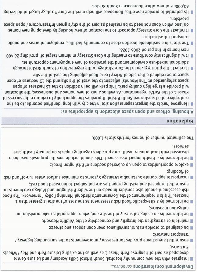
10 1.13 Local Plan Site Allocation 2014 By the time development guidelines were being drawn up for the site in the SADMP, further development on the site, and a changing development emphasis on housing rather than offices and light industrial units, meant that the site was now to provide about 1,000 homes, some offices and a large, high-quality park. The guidance (Appendix 4) included no indicative layout, but besides the key land-uses of a large, high-quality park and housing also specified that: 10 Development should be guided by community involvement; It should secure a large park sufficient in size to accommodate areas of formal open space, sports pitches and the option of a large event space; Provide improved pedestrian links to the Mounds; Include small-scale retail facilities; Integrate with the new community facilities and Play/Wheels Park area; Provide natural surveillance over open spaces and streets; Maintain or strengthen the connectivity and integrity of the Wildlife Network, and provide mitigation where appropriate; Improve as necessary infrastructure for drainage and transport including opening up culverted sections of Brislington Brook if possible; Be informed by a Health Impact Assessment HWPNP Forum Masterplan: The Masterplan produced for the Forum (link Appendix 1 and Figure 5 below) has taken a park first approach to the development of the site. This aims to maximise the regeneration benefits to the local area and South Bristol generally, while creating an improved parkland setting for much needed housing. The Masterplan has a detailed analysis of the site and overarching design guidelines, the Masterplan Moves, which are reproduced from the report in Figure At present the layout shows half of the previous park area retained, while providing 1,400 homes with a density of about 78 dph (dwellings per hectare). The layout has been suggested as one way to implement the Moves, it is expected to be further developed and improved while still respecting the overall design principles. In the suggested layout, natural surveillance of the renewed park is greatly improved, and park and dwellings integrate well. The runway space is retained and developed with formal park features, while set within its original green setting. The big new community facilities of the hospital, leisure centre and skills centre provide a focus for further development of a community hub, with excellent transport links. Around the hub, new apartment housing over retail has been suggested, up to 6 storeys high; elsewhere on the site a mix of 2 storey terraced housing, 3-4 storey apartments and town houses interact closely with the new park.


11 11 Figure 4: The Five Masterplan Moves for Hengrove Park (DHUD 2017)

 1.")

12 1.16 There was general support in the Forum for higher density housing, as it allows the retention of more parkland. The indicative apartment/housing split is shown in table 1 below. It is not possible to be precise in the masterplan at this early stage of drawing up proposals, but a mix of housing and apartments is proposed, at about a 50:50 split. A thorough mix of dwelling types throughout the site will assist with providing a mix of affordable and market housing over the whole site as well. Dwelling Type Number Percentage Apartments % Houses % Mix of apartments and houses % Table 1: Proposed Mix of Apartments and Houses in Masterplan (page 33) 1.17 An area of woodland to the north of the site is proposed to be cleared in the masterplan, and developed for housing. Not an easy decision, but the woodland is unusual and not in good health. The trees are growing through tarmac, as they were planted on the old airfield development. Since being planted many years ago, the copse has not been managed, with the resulting mature trees growing too close together to easily move through. The tree roots are too entangled now to thin the copse, so developing a pleasant woodland area from them is not possible. As housing in this location brings much needed informal surveillance to the Park, the masterplan is currently proposing that the area is cleared and developed. It may well be possible to save individual trees from the copse, but alternative tree-planting will be required elsewhere in the renewed Park as a substitute that in time will be a better resource for wildlife and people. 12 Northern Woodland Area

13 13 Public Sector End User Licence V4.0 July 2013 Crown Copyright Figure 5: The Masterplan proposal for Hengrove Park above and next page


14 14 Figure 5: Masterplan proposals for Hengrove Park: DHUD November 2017

15 1.18 A recent consultation by Bristol CC on revised development proposals for Hengrove Park, have, in the Forum s view, missed some opportunities to create a new and unique place. We hope the ideas we offer, particularly in the Masterplan, can guide the final proposals to a better outcome. In particular we are concerned that the Local Plan and earlier commitments to a large high quality park are getting lost in the desire to provide as much housing as possible. While there is an indisputable current shortage of decent and affordable housing, to provide it at the expense of creating a decent living environment misses a wider regeneration opportunity. The loss of the promised destination park at Hengrove would be a mistake that South Bristol would have to live with for generations to come The local area and community have mostly accepted that the park will become smaller and support the largest number of new homes being built anywhere in the city. However there is a general feeling that the area deserves some benefits to come with accommodating this level of new development. The threatened loss of the promised large park, together with the risk of the loss of existing services such as the library, is generating considerable resentment. The Forum are attempting to promote a scheme for Hengrove Park that will offer benefits to the local area and existing community, quality homes for new residents and an improved place for all. 15 Hengrove and Whitchurch Park Today 1.20 Hengrove and Whitchurch Park, the Ward and Neighbourhood Planning Area, is on the southern edge of the City of Bristol. South Bristol has more than half of the most deprived LSOAs* in Bristol (within the 10% of most deprived LSOAs nationally). Hengrove and Whitchurch Park has pockets of deprivation, with other areas that are slightly above the national average for deprivation. The Ward has a current population of 17,400, and the second oldest population by ward in the City. The national percentage of people aged over 65 is lower, at 17.7% (ONS 2016). Figure 6: Population of the Ward by age, compared with Bristol (BCC Statistical Ward Profile 2017) * LSOA = Lower Single Output Area, a designated area for the purposes of Census output The Ward is ethnically 93.1% White British, much higher than the Bristol average, and just over 5% of the population was born outside of the UK. The population is not healthy, and exercises much less than the average for Bristol. 35%, have a limiting long-term illness or disability, much


16 higher than the Bristol average of 24% (this could be linked to the older than average population). 66% of the Ward s population are overweight or obese compared with a City average of 45%. Therefore opportunities for exercise are particularly important in Hengrove and Whitchurch Park Although crime rates in the Ward are below the Bristol Average, fear of crime is high, affecting day to day life in 22% of the population, compared with only 12% in Bristol generally. It may be relevant to this that the Ward has significant areas with little or no informal surveillance from residential property. The Park and SNCIs for example, and certain places on roads, such as Whitchurch Lane and William Jessop Way. 16 Figure 7: Crimes rates in the Ward compared with Bristol (BCC Statistical Ward Profile 2017) 1.22 There are lower than average levels of volunteering in the community in the Ward, and less than average satisfaction with the Council on all indicators. A very low percentage (11%) of people feel they can influence decisions in the City, compared with an average in Bristol of a quarter of the population feeling they have some influence (25%). All indicators of a community that is feeling neglected and disinclined to engage as a citizen. Hengrove Park, view south
17 17 2. The Vision and Opportunity Hengrove and Whitchurch Park will have the best open space in South Bristol, drawing in visitors from other parts of the city. A re-modelled Hengrove Park will link into and be surrounded by innovative good quality new homes. The Park will provide a green canvas for outdoor activities that all ages and abilities can participate in. The local communities links and resources will be strengthened with new improved facilities including a clear central hub. Objectives: Increase the protection of valued open space and raise more open space to a Good standard. Develop the existing Hengrove Park site with quality new homes that interact well with the new Park and existing residential areas. Create a high quality more formal Hengrove Park in line with the Bristol Local Plan. Increase and improve the range of community facilities in the neighbourhood area to accommodate new and existing residents. Get more people participating in outdoor sports and activities, including active travel and make connections with new and existing routes in the wider South Bristol area. Develop a new hub in the Park development and tie in existing commercial and leisure provision to create an urban form that connects around and across the Park. Provide a range of affordable housing types interspersed throughout the site. Work with existing businesses and community groups to strengthen the community and creative potential within it. Ensure the new Hengrove Park links to existing wildlife corridors in all directions to strengthen the ecological value of the area and provide clear recreational links between the new park and neighbouring areas. Provide formal sports pitches and changing facilities to encourage a more active population to set up and support local sports clubs.
, and the need to rectify this was acknowledged.")
18 18 3. The Policies 3.1 Open Space and Parks A positive regeneration impact from development of the Hengrove Park site will be heavily dependent on the provision of a large, high-quality park, as required by the Local Plan (SADMP). South Bristol was shown to be lacking any formal park in Bristol CC s Parks and Green Spaces Strategy 2008 (PGSS), and the need to rectify this was acknowledged. Development of a high quality destination park as part of the Hengrove Park regeneration proposals was suggested in the PGSS, and became planning policy for the City in both the Bristol Core Strategy (policy BCS1) and then, with further detail, in the SADMP 2014 (see Appendix 4) The Open Space Study for this Plan has demonstrated the potential value of Hengrove Park retained and improved in such a way that links to surrounding open space are strengthened and reinforced. A destination park with links to the wider recreational informal open space of South Bristol has the potential to increase the use and attractiveness of open space beyond the neighbourhood area. Conversely, failing to implement the large, high quality park required by the Local Plan will lose the remaining opportunity to provide a destination park in this part of South Bristol, and with that a key opportunity to improve the desirability of living in the area. Policy HWP2 promotes developing recreational and biodiversity improvements in the wider area South Bristol already has the highest levels of dissatisfaction with local green space in the city, as shown in Figures 8 and 9, and of course this survey was undertaken with Hengrove Park still available in its entirety. The health of the ward s population is poor, and too many people take no exercise (discussed in para 1.19 above). It is crucial therefore that a large open park is retained with informal and formal exercise opportunities in order that improvement in the community s health is encouraged and facilitated. It is also a requirement of local planning policy: Policy DM14 of the SADMP requires development to contribute to reducing the causes of ill health and provide a healthy living environment. Figure 8: Bristol wards and levels of dissatisfaction with green spaces. NB the lowest 4 wards are all in South Bristol, and include Hengrove and Whitchurch Park.

19 19 Figure 9: locational information from Figure 8. Note that the four wards with the lowest satisfaction rates are all in the southern corner of the plan, and Hengrove Park is located centrally within them Besides the lack of a formal park, the ward also has no formal sports provision. Although the South Bristol Sports Centre is adjacent to the Ward boundary, this is a members only facility, which the Council s Parks and Green Spaces Strategy (PGSS) does not recognise as provision accessible enough to be acceptable. As required by the Local Plan and Playing Fields Strategy , the re-modelled park should provide areas of formal sports provision As part of the consultation on the HWP-NDP many ideas were received suggesting facilities people wanted to see in the new park. While these are not incorporated in Policy HWP1 individually, broad aspirations for active recreation and facilities needing to be relocated, or provided to enhance use and enjoyment have. Details of ideas and aspirations for Hengrove Park from earlier consultation as well as current engagement is included as Appendix 3. This also summarises earlier consultation work done by Bristol CC on ideas for improving Hengrove Park and the general preferences of the City s population, both adults and children.
20 20 Policy HWP1: A revitalised Hengrove Park Development Proposals for the Hengrove Park Site as shown in Appendix 4 should include a large high quality park of destination quality. The remodelled Hengrove Park should include the following facilities and design and layout features: Sports pitches for public use; Indoor changing facilities with showers and toilets as a minimum; A new scout hut with secure area around; Historic references to, and information on, the former airport and its history; The runway space retained but imaginatively recreated with physical reference to the historic hard surface surrounded by a grass sward setting retained; An expanded Children s Play Area with facilities for a wide range of ages, linking well into the rest of the Park; Extensive well-surfaced cycle and walking facilities for travel and recreational purposes, linking safely and directly to active travel facilities beyond the Park; Formal Park attractions and planting as agreed; Tree-planting to improve areas of open woodland and replace loss of trees on site; Potential for an events space; Outdoor gym facilities; Improvement of the Mounds SNCI that respects the wildlife and biodiversity value of the site; Better green links between the Mounds and remodelled Hengrove Park. A management plan and ongoing maintenance funding to be a requirement of any permission for the development of this site and Park. Policy HWP2: Linking Hengrove Park to wider Wildlife and Recreational Corridors The remodelled Hengrove Park is to be developed as a connecting hub between existing recreational open space routes and surrounding wildlife corridors shown on Figure 10. Green space and varied habitats should link continuously across the Park from east to west and north to south and to recreational routes linking towards Brislington Brook, Pigeon House Stream and Bamfield and Briery Leaze SNCI as a minimum.
![21 Figure 10: Wildlife corridors linking to Hengrove Park [brown dots are wildlife corridors, which also include the SNCIs shown green; red line shows extent of neighbourhood area] Bristol City](/docs-images/82/86183439/images/21-0.jpg "council mapping 3.1.6 The Ward and neighbourhood area are not rich in heritage assets.")
21 21 Figure 10: Wildlife corridors linking to Hengrove Park [brown dots are wildlife corridors, which also include the SNCIs shown green; red line shows extent of neighbourhood area] Bristol City council mapping The Ward and neighbourhood area are not rich in heritage assets. There are two Grade 2 listed buildings at Bridge Farmhouse, Half Acre Close and the Roman Catholic Church of St Bernadette, and nothing else. Bristol CC has a local list, and the Forum has applied for the runway to be designated under this, currently there are no other local listings in the Ward. The former airport lounge and reception building has gone, and the runway is the only significant physical monument left from an important part of Bristol s second world war heritage and first airport It is understood that the existing tarmac surface will be out of place in the development of the Hengrove Park site, but the runway shape should be preserved in the park redevelopment. Although it is also appreciated that it cannot have the complete setting of a working runway, a grass sward around some of it will carry on a reference to the historic setting. Although a plain hard surface for the entire runway may not be appropriate in the remodelled Park, some of the former width and level hard surface remaining will keep a reference to the historic form. Retaining some of the wide hard surface will also provide an exercise facility and informal recreation feature for people to use as they wish, continue a local practise and encourage new uses outdoor tai-chi classes for example!


22 3.1.8 The Bottle Yard Studios is a key local business supporting national film and television cultural output. It is important the business is protected during construction works from excessive impacts particularly noise and dust. The location of such an important creative industry adjacent to the site suggests the potential for a creative hub to develop in the area. Use of public art projects, both permanent and temporary, to add interest and uniqueness in the new development will help develop the creative hub potential and comply with policy BCS21 in the Core Strategy by reinforcing local identity and character. Besides lifting the new development further as a desirable place to live, public art could also increase built references to the heritage of the Park. Policy HWP3: Public Art, Creative Industry and Heritage Promotion The runway and site of Whitchurch Airport are important local heritage assets in an area that does not have many heritage assets. It is important that the development of the Hengrove Park site preserves the runway space and some of the previous setting. References to the airport heritage should also be incorporated into the wider Park and built environment: public art would do this well. The existing Bottle Yard Studios is an important local cultural industry and its requirements for a low noise and dust environment should be protected as far as possible during construction works. Public Art projects for the Park and new built environment are encouraged in order that the profile of the new development is raised and its distinctiveness and local character established. 22 Public Art in Bristol (Solar Tree courtesy getty images Angel Villalba)
23 3.1.9 The Open Space Study for the neighbourhood area (link - Appendix 2) assessed all open space within the Ward. The quality was found to be variable, averaging fair, a finding that has not changed since the Council undertook an assessment as part of the work for the PGSS in 2005/6. The standard aspired to in the SADMP is good, so most open space in the Ward needs improving to meet this standard. In order to achieve this, Policy HWP4 places an emphasis on any requirement for open space, other than at Hengrove Park, to be on improving existing open space. Planning Policy in the development plan for Bristol does not specify a size of residential development above which open space is to be provided. Thus Policy HWP4 refers only to the need for appropriate contributions, which will be measured by the size of the development and other relevant material considerations Although most of the open space in the Ward has been designated as such in the SADMP, there are additional small areas that were not designated but are important (shown on Figure 11). This Plan has included open space designated in the SADMP, as well as allotments and the community farm which were not designated in that document. Together Figures 11 and 12 show the location of all open space designated by Policy HWP4. Policy HWP4: Open Space in Hengrove and Whitchurch Park Sites shown on figures. And listed below are designated as open space. Development of these sites, that does not enhance the use of the site for its current open space use, will not be permitted unless an alternative area of open space is provided of equal or better quality and accessibility to the local community. The re-location of any area of open space should not create a shortage of open space, as defined by the Parks and Green Spaces Strategy 2008, in the original area. Areas to be protected as open space are as follows: 23 Land between Copeland Dr and Wedgewood Close Land between Allerton Road and Evercreech Road Corner of Rookery Way and Court Farm Road Land fronting Coulson s Road St Giles Allotments Oatlands Allotments and Severn Project Hartcliffe Community Park Farm East Dundry Slopes SNCI (within neighbourhood area) Bamfield and Briery Leaze SNCI Hawkfield Meadow SNCI Land fronting Fortfield Road Land fronting Allerton Crescent Land off Warncliffe Gardens Land fronting Tanorth Road Land fronting Airport Road Half Acre Allotments Fortfield Road Allotments Land off Smythe Croft Coulson s Park Hartcliffe Millenium Park Land fronting Belland Drive Land fronting Whitchurch Lane Residential Developments other than the Hengrove Park Regeneration Site will be required to contribute appropriately to the improvement of existing open space as an alternative to providing more space within the development unless specific site conditions indicate a need for onsite provision.

24 24 Map courtesy of Bristol City council Public Sector End User Licence v4.0 July 2013 Crown Copyright

25 25 Figure 12: Land Designated as Open Space or Local Green Space in Policies HWP4 and HWP5
26 The NPPF, government planning policy issued in 2012, created a new power for Neighbourhood and Local Plans to designate special areas of open space as Local Green Spaces (NPPF paras 76-77). The NPPF makes it clear that the designation will not apply to most areas of open space, and that any area so designated must be special to the community in terms of attributes such as recreational value, ecological or historic importance, beauty, tranquillity or visual importance. Table 1 shows the areas of open space considered special in the ward, and suitable and worthy of the designation. The reasons for designating the sites are also set out in the table. Local Green Space Area Reasons for designation 26 Hengrove Park (as remodelled in new development) and Green Fingers, St Giles Estate Estimated at 30 Ha Historic value and heritage on the site links back to the original Bristol Airport and World War 2 transport activities, the runway still exists. A valued informal recreational resource with landscape and townscape value that is due to be enhanced with the re-development. The Green fingers of St Giles are to be included within the designation as important physical and visual links to the Park from the adjacent residential area. Hengrove Park Children s Area and Skate Park Whitchurch Green The Mounds SNCI Hartcliffe Community Park Farm 1 Ha It has a city-wide recreational value for children and young people, and is a valued resource locally in an area under-resourced with children s play areas. A designated Town Green, Whitchurch Green provides informal recreational facilities and the tranquillity and beauty of open space in the context of its residential surroundings. An active community group encourages engagement in planting and events. A quiet wild area that is valued for informal recreation and designated an SNCI for its ecological value. It offers a needed habitat variation to the adjacent Hengrove Park. A city and community farm established for 30 years, Hartcliffe Community Park Farm practices organic farming and promotes the protection of habitats and ecological value. With café and children s play area, allotments and livestock, it has an important landscape and recreational value. Also valued community resource with educational purpose.

27 27 St Augustine s Park Hengrove Farm Community Woodland A local park well used by the surrounding community and offering an essential recreational resource with its children s play area and walking and cycle routes. It has a landscape value with mature trees and open space within a dense suburban setting, and offers tranquil space to relax in. A local park in a part of the Ward that is severely lacking in easy access to open space. There is a historic link to the farming history of the area, and recreational value in the Park. Links to the north to the Brislington Brook and wildlife corridor enhance the ecological value of this park. Policy HWP5: Local Green Space The following sites, shown on figure 12, are designated as Local Green Space: Hengrove Farm Community Woodland Hartcliffe Community Park Farm Hengrove Park Children s Area and Skate Park St Augustines Park The Mounds SNCI Whitchurch Green Hengrove Park (as remodelled in new development) and Green Fingers, St Giles Estate Development on Local Green Space will only be permitted if it enhances a use and reason for designation of the site or in other very special circumstances. Hengrove Park will be partially developed for residential use but this will not impact on reasons to designate it due to policy requirements to retain a high-quality large park and make improvements to the existing park. Hartcliffe Community Park Farm

28 The Ward has a reasonable provision of allotments, but the Open Spaces Study shows current provision is slightly less than the requirements of the City Allotment Strategy. There are waiting lists of people wanting an allotment on each local site, and developments of significant new residential homes should provide sites for the new residents to ensure demand does not seriously outstrip supply and turnover. The Allotment Strategy requires 7 traditional sized plots of 253sqm per 1,000 residents or 1.77sqm per resident. This is also the requirement for Hengrove Park in the development brief, although as the number of homes proposed for the site has risen from the Local Plan estimate, this requirement should also rise Current practice among allotment holders frequently subdivides allotments or shares them, and it would be sensible to provide more allotments of a smaller size, as for example is the practise in Wiltshire (plots now sized at 100 sqm). An area of 100 sqm is required for about 56 people, or the number of residents that could be expected to inhabit 25 smaller dwellings. Thus Policy HWP will require smaller sized allotments of 100 sqm to be provided on sites of 25 or more dwellings, the provision to rise in line with the projected number of dwellings. Policy HWP6: Allotments New residential development of 25 units or more will be required to provide allotment space of 100 sqm per 25 residential units, provision to rise proportionately with the number of residential units. Such space may be provided on site or off-site if in reasonable proximity to the development, in either case the land designated for allotments must be suitable for horticultural use and maintained for allotment use in perpetuity. Alternatively a financial contribution may be made of equivalent agricultural land value to improving open space and allotments in the neighbourhood area. 28 Oatlands Avenue Allotments
29 3.2 Housing and Regeneration The Local Plan for Bristol allocated several residential development sites within the neighbourhood area, which apart from Hengrove Park provided approximately 585 homes, some of which are already built. This plan is proposing more homes for Hengrove Park than the Local Plan suggests, but the masterplan exercise has shown that this can be accommodated on the site and still retain a large, improved park. 261 homes on Phase 1 of Hengrove Park have just received planning permission, so that the 1400 homes suggested by the masterplan will in total increase the suggested allocation of 1,000 homes in the Local Plan by about 660 to 1,660 in total About three quarters of the existing homes in the Ward are owner-occupied. 44.6% of all homes are semi-detached, significantly higher than the Bristol average of 26.3%. Detached and terraced homes are consistent with wider Bristol averages at 8.3% and 35.2% respectively, but there are significantly fewer flats in the Ward than the City overall, 11.8% as opposed to 34.4% *. Providing some apartment blocks on the Hengrove Park Site, within the constraints of design that respects the surrounding low-rise dwellings, could help to widen the current choice of dwellings within the Ward therefore Consultation revealed that there was a general feeling that some higher density residential development of several storeys at certain places on the site would be acceptable to ensure the retained park still had the open expanse valued in the existing site. Building higher also offers the opportunity to provide a varied visual built environment within the predominantly 2-storey suburban environment of South Bristol, and a wider variety of dwelling size and type, currently missing from the area, which is comprised of over 70% dwellings with three or more bedrooms, and less than half of the Bristol average of one bedroom dwellings The ward has a mix of areas of significant deprivation, together with areas of market housing that are not disadvantaged. It is important that development on the site provides affordable housing, but this should not create potential ghettos of deprivation. To guard against this, Policy HWP7 requires affordable housing to be interspersed throughout the site Help to Buy South has provided recent figures for the demand for shared ownership schemes of various types in Bristol. In 2015 there were a total of 1,322 applicants, in 2017 this number has more than doubled to 2,842. Help to Buy report that 150 properties of the various shared ownership/rent to buy schemes were completed in the year November 2016 to October 2017, so demand is likely to grow further. Demand for a house is greater that for flats, but 43% of applicants were happy to consider any property, and 14% specified a flat. Two bedroom properties were the most in demand. 29 * All figures quoted above in this section from the Bristol CC Statistical Review 2017.
30 30 Policy HWP7: Residential development at Hengrove Park The Layout of development on the Hengrove Park site will comply with and follow the five Masterplan Moves of the Hengrove Park Masterplan in order that a high quality large park is created out of the existing Hengrove Park and the new residential development interacts well with the new park and greatly increases the level of informal surveillance of the Park. Approximately 1,400 dwellings will be provided on the site, of varying type, size and tenure. The Park footprint to be broadly as shown on the Masterplan, reproduced as Figure 5 in this Plan and available via the Appendix 1 link. Good Design will be required throughout the development, with legibility created through the use of design features, height and massing of buildings as well as public art. Maximum interaction with the Park and new residents is to be encouraged with soft boundaries and the use of green fingers into new residential development. In line with Local Plan policy a minimum of 30% Affordable housing is to be provided on site, to include some shared ownership scheme dwellings, and to be interspersed throughout the site The neighbourhood area and ward has significantly higher than average numbers of elderly people living in it. The Council s Statistical Ward Profile 2017 shows that people over 65 are 20.8% of the population in the Ward, compared with only 13.2% in Bristol generally and 17.7% nationally. Many elderly people wish to remain in the area, but will be increasingly challenged by accommodation becoming increasingly unsuitable. The Ward has a high percentage of homes with 3 bedrooms or more at 70.4%, and a very low level of overcrowded households. There is a statistical indication therefore that a feature of the housing situation in the Ward is underoccupation. By this we mean larger family homes occupied by single people or couples, some of whom may be elderly and beginning to find the upkeep of a larger house and garden a burden. Provision of specialist housing suited to the elderly, with varying elements of care, is likely to encourage the release of under-occupied housing. Policy HWP2 aims to increase the provision of housing for the elderly in the Ward in order that the range of housing generally becomes more balanced, and older people who wish to leave unsuitable accommodation can do so without moving from the area. The policy is based on Policy DM4 of the SADMP which deals with Wheelchair accessible housing particularly for the elderly. The percentage has been raised in Policy HWP to allow for the higher percentage of elderly people in the Ward, which is more than half as much again as in Bristol generally. Policy HWP8: Provision of Housing for the Elderly Three percent of new housing within residential developments of more than 40 dwellings should be designed to be wheelchair accessible as defined in the current edition of the wheelchair Housing Design guide. Provision to be proportional to the nearest whole number of dwellings.

31 3.3 Community Facilities and Health A key comment in all consultation on the development proposals for the Hengrove Park site are fears about the impact of up to 5,000 new residents on existing facilities, which are already under pressure from funding shortfalls. Health provision and education are particular concerns, as well a library facilities at the time of writing the Whitchurch Library was potentially to close. It is generally acknowledged that if communities are to embrace the opportunities of new development in their area, they have a right to expect that expanded and improved services will also be provided. The regeneration proposed at Hengrove Park offers potential benefits to the local community, but most visible at present is the loss of at least a half of a valued and much visited Park Figures 13 shows a reasonable provision of pharmacies in the Ward, but fewer dentists and GP surgeries than surrounding areas. The Clinical Commissioning Group for the local area has indicated an interest in extending facilities at their site, and Policy HWP10 supports this. 31 Figure 13: Provision of health facilities and pharmacies in the Ward and surrounding area Community facilities in the Ward are under pressure, financially challenged and oversubcribed or threatened with closure. Several thousand new residents coming into the Ward, as well as the existing community deserve better. For this reason, the development of new and expanded community facilities in the proposed local hub for the Boulevard area are promoted in Policy HWP9. The Masterplan indicated the best place for a new local centre in the Hengrove Park development is around the Boulevard, a currently pedestrianised area between the Hospital and Leisure Centre. There are small development areas allocated here that are suitable for higher

32 storey development suited to the surrounding more monumental buildings, with interactive ground floor uses, and residential apartment development above. The public transport hub coming into the site at this location reinforces its suitability as a local centre. 32 Figure 14: Community Facilities in the ward and surrounding area (black squares = community centres) Map courtesy of Bristol City council website facilities for public information. Policy HWP9: New Community Hub and protection of Community Facilities A Community Hub and Local Centre should be developed as shown on the masterplan around the Boulevard to include small shop units suitable for retail use and a new community centre. The Community Centre to include meeting and small event rooms, café, joint one stop shop council services and a library if possible, and other facilities as opportunities arise, including museum artefacts explaining the history of the area and airfield. Proposals for uses that would aid self-sufficiency of funding and maintenance will be considered favourably. Development proposals for change of use or redevelopment of existing community facilities will not be supported unless it can be shown that the facility is no longer viable or it is proposed to provide an alternative facility of equal or better standard and accessibility. Policy HWP10: Extending GP Surgery Provision The extension of GP surgery provision at the Whitchurch Health Centre is supported. Other proposals for new GP surgeries will be supported providing they comply with other policy in the Development Plan.
33 3.3.4 Bristol CC is moving to a new way of making decisions on spending local CIL receipts and other developer contributions. They point out the government CIL guidance suggests Neighbourhood Plans should set out community priorities for spending CIL locally, and so Policy HWP11 does this. As priorities change over time, the Policy has a caveat concerning the list not being exclusive or limiting should other projects and priorities arise. Policy HWP11: Priorities for Community Infrastructure Levy Spending Financial contributions from development to be spent in line with local community wishes will be allocated to community priorities agreed at the time by the Hengrove and Whitchurch Park Neighbourhood Planning Forum and other community bodies. They may include but not exclusively the projects listed below:- The delivery of improved community facilities and a Community Hub; Support for a new health centre and GP surgery; General improvements to the open space and parks in the neighbourhood area; Improvements for cycling and walking facilities; 33

34 3.4 Sustainable Travel The Ward has a higher car ownership level than average for Bristol, reflecting the outer suburban location. Figure 15 shows the Ward among the highest in the city, with an ownership level of 1.27 cars per household. The September questionnaire asked people whether they owned a bicycle, and 35% of respondents did (77 people), although of those 23 people used it only rarely or monthly. 28% of respondents used the bus service most days or weeks, 37% only used it rarely, with 35% of people using it sometimes. The service rating averaged OK, so there is room for improvement, which could encourage more people to travel by bus. Similarly, better cycle facilities could encourage more use of the cycles people currently own, as well as an expansion of households owning bikes. The rapid transport system in development should also encourage more journeys to be made with sustainable travel choices, as long as the service reliability frequency and journey time all improve. 34 Figure 15: Levels of car ownership in Bristol wards (BCC Ward Profile Report 2017) The new development will cause significant extra traffic in the Ward, a cause of concern frequently expressed in consultation. It will be important that new ways are sought to encourage wider travel choices and reduce the need for every household to own at least one car. The new dwellings on the Hengrove Park site are likely to be higher density development than the surrounding residential areas, and thus more suited to the introduction of car clubs and other carsharing systems. Policy HWP12 encourages this provision, besides better cycle and pedestrian facilities and electric car charging points to encourage active and sustainable travel. Policy HWP12: Promoting Sustainable and Active Travel Development on the Hengrove Park Site should include charging points for electric vehicles and parking for the Bristol shared use cycles, spread around the site. A car club for residents both new and existing should operate from points within the site and other car-sharing schemes also encouraged. Links to surrounding cycle routes and facilities should be strengthened and improved with any road crossings made safer with the provision of crossing facilities to suit predicted levels of motor vehicle traffic. Cycle and pedestrian links across the site should be direct, with a sealed surface and well lit, but not intrusively so.
35 35 Appendices Appendix 1: Masterplan for Hengrove Park Nov2017 DHUD Appendix 2: Open Space Survey Nov2017 LB Planning
36 36 Appendix 3: Relevant Consultation on a new Hengrove Park. A3.1 The Questionnaire the Forum circulated to all households in the summer of 2017 asked several questions that are pertinent to consideration of what improvements the new Hengrove Park should make, and they are summarised below. The full report of questionnaire responses can be accessed in the Consultation Statement accompanying this Plan. A3.1.2 The questionnaire asked When you exercise do you Walk? Run? Cycle? Other. Of people who just walked for exercise, 77 were aged over 65 (56%), 33 were aged under 66 (38%): indicating that being able to enjoy walking as exercise is more important for the elderly as it is likely to be their only exercise. Table 8 which summarises all responses to the question (including multiple responses) also reinforces this finding. More older people walk rather than swim or cycle or cycle for exercise, and running is generally not an exercise form used by the over 65s. Table 8: Type of Exercise undertaken All respondents age <66 Walking (37%) Swimming (60%) Running (95%) Cycling (61%) The other sports included as types of exercise undertaken included dance (5); Badminton (2); gym (7); bowls (2); golf (3); keep fit (5); none (2); gardening (2); circuit training; kickboxing; climbing; tennis; Housework; Tai Chi; and Yoga. A3.1.3 The questionnaire asked specific questions on Hengrove Park, as follows: 8. Hengrove Park Table 10: Frequency of visits to Hengrove Park Frequently 58 Regularly 48 Occasionally 83 Total visitors 189: 90% of respondents to this question. Reasons for visit: Walking 93; supervised play with children 59; Dog walking 48; Cycling 18; Exercise 17; Car Boot Sale 16; Access to places and buses (shortcut) 16; Pleasure/Leisure/Recreation 11; Running 10; relaxing 8; Cinema/eating out 7; Watching or playing Rugby 7; Hanging out/meeting people 7; nature walks/bird watching 6; Picnics 4; enjoying sitting 2; Plus single mentions of meditation; events (glowrun); picking wild fruit; flying drones; badminton; conker collecting; ball games.
37 8.1 Only 22 respondents never visited Hengrove Park, and 17 left the question unanswered. Table 10 sets out the frequency of visits reported from those who do visit, and also in this box are the reasons given for visiting. The latter show a considerable range of activities many respondents offered more than one reason. Reasons such as peace of mind, solitude and breathing space were noted under relaxation, but indicate the mental health benefits of successful green spaces. Other replies included access to fresh air and the views ; both reported under Pleasure. One respondent noted how much their grandchildren enjoyed the Park on their visits and there was a clear implication in the number of mentions of visits with grandchildren, that many children were enjoying the park on visits to grandparents. The category Supervised visits with children include comments such as family time, entertaining grandchildren, playing with nieces and nephews, playing with my children ; all comments that indicate the potential social benefits of green space besides the exercise and health values. 8.2 The question on whether the runway space should remain in any new development was answered by 206 respondents, of whom 113 said yes, and 62 chose the response some of it. Only 27 people did not want it to stay, one person wasn t sure, one answered depends. The runway features as a favourite place in the park for 5 people, although answers to this question generally indicate that it is the complete park that people respond to, 58 reported no favourite place, 42 nominated the whole park, and 74 respondents didn t answer the question. 8.3 Asking what improvements would people like to see to the park got a more positive and engaged response. 14 people wanted it left as it is, but Table 11 sets out a range of ideas for improvements with the number requesting them alongside. Despite the large children s play area in the park, there are requests for play areas, making the play area bigger and including facilities for all ages and young people. Work with children has also indicated that there is an age range (about 7-14) that is not big enough for the skate park, but feels too old for the play area. Indeed offering alternative older play facilities may be necessary in order that the dominant children do not crowd out others from a single resource girls are particularly vulnerable in this regard. Table 11: Suggested Improvements for Hengrove Park More Seating 30 More bins inc dog waste bins 26 Exercise area, cycle and running track Gym, cycle paths and more activities 27 Better maintenance, security, lighting 20 More trees 18 Flower beds and planting 13 Coffee shop/restaurant 12 Lake/water feature (fountains) 10 Play area made bigger/new one 8 Promote the history 6 Community Hub 5 Picnic area 4 Events 3 Warden 3 Toilets 2 Clinic/Library/no cars on the park 1 37
38 38 A3.2 Drop-in events in July and August elicited the following postit note responses: Should we keep or remember the runway and how? 5 th August Keep it improve it. Its important to have some open space and somewhere to cycle Keep the runway in some form as it is an important part of Bristol history Keep it, resurface it and re-mark it to remember our history Incorporate the historical runway into community development Keep the runway and use it for model aeroplane and car fests also get the young school children riding to learn to cycle and highway code KEEP-IT Keep it as a walkway Keep it a historical 2 nd WW place It is an important piece of national architectural history. Whitchurch airport was unique and should be remembered with interpretation signs and kept for leisure use. Should we keep or remember the runway, and how? July 15 th Keep the runway. It has in the past been used many times for bus and lorry rallies/exhibitions. The runway has also been recently designated as a drone and model aircraft flying site. Keep runway. Line the length with floral arrangements and seating accommodation. Information on the history of runway. Keep to the original plan. Houses around central green space with seats. Keep the runway. Incorporate into design. After all it is part of our history. Better to lose the runway and retain more green Keep it and improve it. Keep as open space Yes it is part of our history. The only fully operational runway in WW2 Keep the runway as it is. Too many walking areas are constantly changing to building sites. The runway is part of local history, but should be replaced as grassed or plaza type with seats, trees and flower beds and be the central hub of the open space. A history board similar to the one on St Giles estate would inform people of its past. Keep it but improved and used as an open space. Keep part, incorporate in new road. Landscape. There is already a plaque. Remove the runway as it takes up too much park space. Yes kept as an open space. Keep runway use it for drag races.
39 39 Yes but also keep large grassed area. Planting (low level) adjacent to runway. Remember it, if it can be incorporated into green space. Yes keep runway. It s part of history of area. Yes, keep it. We have little of history left in this area. Like the plaza idea though. We do need to progress. Keep the runway and develop the surrounding area as a community hub with parkland. With some help from heritage England foundation to re-instate the runway into a protected site. What would you like to improve? July 15th Would like to see dog waste bins emptied and rubbish bins and glass swept up and cleaned behind car boots. Contractors doing what they are paid for. More bins collected more often. Fields for football, rugby, cycling. More benches and picnic area. Toilets. Wildflower meadow. Better maintenance of the space. Grass cut paths repaired bins emptied. More trees and structure. Keep as much open space as possible. Council to look after park better than what they are supposed to be doing. Grass cutting, emptying of bins, and stopping of anti-social behaviour. More woodland. More trees and benches. Would like to see flower beds, water features, greenhouses and fruit and veg. More benches, trees, footpaths. Traffic access from Hengrove Leisure to improve traffic on Bamfield. General upkeep and to make more of recreational area! More tree, plants for the wild life. Safe place for children to explore and play. More dog bins and empty more often. Keep good open space fulfil promise from council that we have a large park like Bath park.
40 40 What would you like to keep in the Park? 5 th August All the green space either side of runway. Leave the trees Green open space As much green space as possible A nature reserve for the skylarks, newts, butterflies and flora Trees, green space As much as possible should be kept, especially trees and open space which is widely used by local people from any areas as well as nature Grass land and runway. History art work must be kept What would you like to improve? 5 th August More bins on Hengrove park. Bins have been removed and not replaced Rubbish collections No car boot sale More bins to be emptied regularly. Runway retarmaced What else would you like to see in the park? 5 th August Doctors, schools, shops, community centre, bus routes Shops to deal with extra housing Sports area. Park left as it is. Fountains. Proper seating areas Green space very important for mental and physical health and wellbeing Lake, trees New school. Doctors surgery etc. Leisure centre New School, closure of perry court to meet need Leisure facilities extensive Additional health centre Leisure facilities to meet demand Sports and recreation facilities Health centre, community centre
41 What else would you like to see in the park? 15 th July Encourage wildlife Café!! Made more park like benches, planting etc. Plants/flowers with coffee/café Toilets Café and toilets. Seating. Flowers and nature and sitting area with water feature. I would like a proper park like Bath park with tree plant for wildlife. Toilets, benches and café. Picnic area. Benches. Toilets. Trees. A café and toilets. More Green space for families and older people to enjoy and use as a proper recreational area i.e. nice gardens, benches. A Café When it rains a lot I have noticed that there is an oil film floating on top. This is the area around St Giles Estate near Hengrove Way. Small Café. As it is only open space/recreational. A Café. Toilets. Native fruit trees and flowers for pollinators. Café. Nature walks. Good landscaping around housing. More facilities for benches in set out garden area with refreshment areas. What would you like to keep in the park? Rugby pitch Remain as it is. No more buildings. To remain as it is ideally!! As it is the only nice green space in Whitchurch. Rugby club and pitches. Open spaces. Just OPEN! Space. Everything. Large green space. Rugby pitch. Park for children. The mature trees already there. Nature reserve. To remain as it is. Only open space/recreational area in a built up poorly resources area. Same as Grass and trees. All of it. 41
42 42 Leave it as a park. Most of it kept as grass and trees. Everything. Important to be able to let dogs off lead. This is only space around here which is safe from traffic and on a hot day walk in the trees. Trees and grass. As much of it as possible. All of it. It s a beautiful space for all to use. All of it Some green space must be kept i.e. the mounds. A large green are of parkland with facilities for outdoor sport. What types of open space and activities should be included? Place to walk safely dog to walk. Children to cycle play football etc. Nature walks. The children s play area extended. Large open space for kids to cycle, play football etc. Children play area made much bigger with additional one for younger children. The festival of transport was always good. New site for a mini Glastonbury. People of all ages are able to generate their own activities as and how they wish. The park to work for them they will only require playparks shops cage etc. if offered. The remaining park should back onto Bamfield. The children s play park made bigger, similar to Blaise castle as it gets very overcrowded in summer. Nature trails around airport. A large open green space. Picnic benches, kids play area extended. Green space! Seating areas with flowers/vegetation. Walkways through the park. Nature recognition and appreciation. Kid s playground. Rugby pitches. Dog walking. Recreation area including benches, gardens for all to enjoy i.e. St Georges Park, Keynsham Park!

43 43 A3.3 Previous consultation by Bristol CC on Hengrove Park for the Area Green Space Plan received the following responses (Hengrove and Stockwood AGSP 2010: page16):

 and Children (CD survey undertaken in")
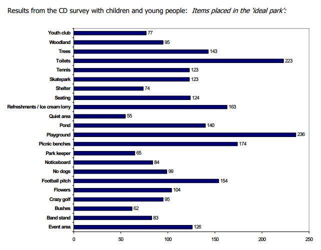
44 A3.4 Research Work for the Parks and Green Spaces Strategy 2008 found the following general preferences from adults (P&GSS Survey ) and Children (CD survey undertaken in schools): 44
45 45
, where they lived (yellow dots) and places they did not like")
46 46 During the drop-in consultation on the NDP in July and August 2017, a dots exercise was undertaken. On a large aerial photo of the neighbourhood area, people indicated open space they visited (green dots), where they lived (yellow dots) and places they did not like (red dots). This photo shows the combined results from both events.

47 47 Appendix 4: Development Brief for Hengrove Park: SADMP 2014 Site Allocations Annex
48 48
Open Spaces Study November 2017
 Hengrove and Whitchurch Park Open Spaces Study O November 2017 Acknowledgements: This study was undertaken by LB Planning for the Hengrove and Whitchurch Park Neighbourhood Planning Forum in the autumn
Hengrove Park Phase 1. BUDF Briefing. Kier Living. Stride Treglown job no Prepared by Checked by Date January 2017 Revision -
 Hengrove Park Phase 1 BUDF Briefing Kier Living Stride Treglown job no. 32507 Prepared by ACR Checked by RD Date January 2017 Revision - Revisions Revision Rev A Description Description of revision(s).
WELCOME. Land North of STEVENAGE. We would like to thank you for attending our public exhibition today.
 WELCOME We would like to thank you for attending our public exhibition today. The purpose of this event is to share our proposals and hear your thoughts on our ideas. Members of the project team are on
WELCOME GYPSY LANE. Wider Site Location plan. Proposals for the development of LAND OFF FOXLYDIATE LANE WEBHEATH. Proposals for the development of
 WELCOME The developers are preparing an outline planning application for a residential led development and need the community s views in order to develop the proposals further WHAT IS PROPOSED? A high
WELCOME TO THE NEW WILTON PARK
 WELCOME TO THE NEW WILTON PARK VISION HISTORY OF WILTON PARK TOWARDS A PLANNING APPLICATION Our objective is to create a truly outstanding environment at Wilton Park. At the heart of our proposals is a
Welcome to our public exhibition
 About our development Welcome to our public exhibition This exhibition gives you the chance to view and comment on our proposals for a new residential development of 165 high-quality homes, along with
Newcourt Masterplan. November Exeter Local Development Framework
 Newcourt Masterplan November 2010 Exeter Local Development Framework Background The Exeter Core Strategy Proposed Submission sets out the vision, objectives and strategy for the development of Exeter up
INTRODUCTION NORTH HEYBRIDGE GARDEN SUBURB
 INTRODUCTION This event is being hosted by the promoters of the proposed North Heybridge Garden Suburb who are working with Maldon District Council and other key stakeholders on the preparation of a comprehensive
Briefing Document of CNP. June 2017
 Cholsey Parish Council Cholsey Neighbourhood Plan Briefing Document of CNP June 2017 Cholsey Neighbourhood Plan Page! 1 of! 8 Cholsey Plan Briefing v1.4 Page Left Intentionally Blank Cholsey Neighbourhood
BLETCHLEY PARK AREA - DEVELOPMENT FRAMEWORK
 ANNEX A To Item 9 REVISED TEXT: additions shown bold and underlined, deletions in (brackets and in italics). BLETCHLEY PARK AREA - DEVELOPMENT FRAMEWORK This framework sets out the key objectives and requirements
Neighbourhood Planning Local Green Spaces
 Neighbourhood Planning Local Green Spaces Introduction... 2 1. Why green space is important... 4 2. Neighbourhood plans and green space... 6 3. Evidence... 8 Statutory designations... 9 Green space audit...
Land at Rampton Road. Cottenham
 Land at Rampton Road Cottenham Introduction TEP is preparing an outline planning application for 54 dwellings on 6.9 hectares of land adjacent to Rampton Road, Cottenham on behalf of the owners Cambridgeshire
Welcome to our public exhibition
 About Our Scheme Welcome to our public exhibition This exhibition gives you the chance to view and comment upon our emerging proposals for a new residential development of 68 new homes on the site of the
WHITELEY TOWN COUNCIL NORTH WHITELEY DEVELOPMENT SEPTEMBER 2014
 WHITELEY TOWN COUNCIL NORTH WHITELEY DEVELOPMENT SEPTEMBER 2014 Dear Resident This Special Edition of the Whiteley Voice which has been prepared in conjunction with the North Whiteley Consortium is to
Welcome to our exhibition
 Welcome to our exhibition The Homes & Communities Agency (HCA) welcomes you to this public exhibition explaining our proposals for the redevelopment of the former Lea Castle Hospital site. About the Homes
Chapter 2: OUTLINE PLANNING APPLICATION PROPOSALS. A New Garden Neighbourhood Matford Barton 17
 Chapter 2: OUTLINE PLANNING APPLICATION PROPOSALS A New Garden Neighbourhood Matford Barton 17 2.1. SUMMARY AND STATUS OF THE PROPOSALS 2.1.1. The parameter plans and associated wording in this chapter
Planning and Sustainability Statement
 Land adjacent to Manor Farm, Catterick Village Pallett Hill Sand and Gravel Co Ltd Proposed 10 new dwellings, (6 No market dwellings and 4 No affordable dwellings) with access, associated car parking and
Public Consultation. Land at Monks Farm, North Grove. Welcome
 Welcome Welcome to our public exhibition for development on Land at Monks Farm, orth Grove. Gallagher Estates and Gleeson Strategic Land are preparing an outline planning application for new homes, open
3.1 The hybrid planning application proposes the following description of development:
 CHAPTER 3: PROPOSED DEVELOPMENT 3.1 The hybrid planning application proposes the following description of development: Hybrid (part-outline/part-full) planning application for a single composite development
Wildlife and Planning Guidance: Neighbourhood Plans
 Wildlife and Planning Guidance: Neighbourhood Plans This Leaflet is one of a series of 4 Wildlife and Planning Guidance Leaflets and is intended to provide useful information to assist you to campaign
Key Principles. 290 Phasing Principles and Programme
 4 Phasing principles and programme 4c The aims of the phasing strategy are to satisfy planning policy requirements and create a sustainable, strong and healthy new community where, from the outset, people
GREENFORD HALL & ADJOINING LAND
 GREENFORD HALL & ADJOINING LAND CONTENTS 1. Introduction 1. Introduction 2. Urban Context 2.1 The Site and Surroundings 2.2 Urban Context Map 2.3 Access and Movement 3. Planning Context 3.1 Planning History
Rochford District Council Allocations Development Plan Document: Discussion and Consultation Document Sustainability Appraisal
 Option SWH1 Balanced Communities Option SWH1 1 To ensure the delivery of high quality sustainable communities where people want to live and work Will it ensure the phasing of infrastructure, including
ROCHFORD LOCAL DEVELOPMENT FRAMEWORK: Sustainability Appraisal/ Strategic Environmental Assessment. Rochford Core Strategy Preferred Options Document
 ROCHFORD LOCAL DEVELOPMENT FRAMEWORK: Sustainability Appraisal/ Strategic Environmental Assessment Non Technical Summary Rochford Core Strategy Preferred Options Document October 2008 SUSTAINABILITY APPRAISAL
Droitwich Spa 6. Reasoned Justification
 87 Droitwich Spa 6 Reasoned Justification 6.1 Droitwich Spa is identified in the settlement hierarchy (Policy SWDP1) as a main town being the largest settlement in Wychavon District with an estimated population
Schedule of Planning Applications Committee Date: 23 May Reference: 06/17/0726/F Parish: Hemsby Officer: Mr J Beck Expiry Date:
 Schedule of Planning Applications Committee Date: 23 May 2018 Reference: 06/17/0726/F Parish: Hemsby Officer: Mr J Beck Expiry Date: 22-05-2018 Applicant: Proposal: Site: Mr Gillett Change of use to the
Former North Works, Lickey Road, Longbridge, Birmingham
 Committee Date: 14/11/2013 Application Number: 2013/06431/PA Accepted: 27/08/2013 Application Type: Full Planning Target Date: 26/11/2013 Ward: Longbridge Former North Works, Lickey Road, Longbridge, Birmingham
OKEFORD FITZPAINE NEIGHBOURHOOD PLAN
 OKEFORD FITZPAINE NEIGHBOURHOOD PLAN Dear Parishioner, The Neighbourhood Plan Project Team have prepared this leaflet to summarise the full Neighbourhood Plan document. It provides a summary of the Vision,
The proposals presented in September drew a large number of comments and feedback and have been grouped together as follows:
 Appendix A Stakeholder presentation + powerpoint slides Planning Context and Emerging Proposals presentation Nick Tyrrell, Alder King, Planning Consultants Alder King began by setting the site context
Neighbourhood Planning Guidance Local Green Spaces
 Neighbourhood Planning Guidance Local Green Spaces Introduction This guidance note has been produced for communities preparing neighbourhood plans in North Dorset to help them to identify, assess and designate
LONGDEN VILLAGE DEVELOPMENT STATEMENT
 LONGDEN VILLAGE DEVELOPMENT STATEMENT 2017-2027 1 Longden Development Statement 2017-2027 15/01/18 1. Background 1.1 Longden Village Longden village is a very rural and traditional community first mentioned
Stantonbury Neighbourhood Plan
 Stantonbury Neighbourhood Plan 2018-2031 Basic Conditions Statement October 2018 Intentionally blank 1.0 Basic Conditions Statement Introduction 1.1 This statement has been prepared by Stantonbury Parish
Kibworth Harcourt. Introduction. Introduction
 Introduction Introduction Welcome to this public exhibition on the proposals for the delivery of new homes on land at The Kibworths. The purpose of today s exhibition is to give you the opportunity to
Welcome. Proposals for land at Smug Oak Lane BRICKET WOOD
 Proposals for land at Smug Oak Lane BRICKET WOOD Previous Linden Homes and Wates Developments scheme Welcome Welcome to Linden Homes and Wates Developments public exhibition. Working together as joint
Cotswolds AONB Landscape Strategy and Guidelines. June 2016
 Cotswolds AONB Landscape Strategy and Guidelines June 2016 Cotswolds AONB Landscape Strategy and Guidelines Introduction The evolution of the landscape of the Cotswolds AONB is a result of the interaction
Environmental and Landscape Mapping
 Environmental and Landscape Mapping In support of the Calveley Neighbourhood Plan November 2016 Project Name and Number: Calveley Neighbourhood Plan 16-025 Document Name and Revision: Environmental and
A VISION FOR BLAIRGOWRIE
 Welcome to the Westpark Partnership and Lidl UK GmbH Community Presentation. The purpose of this presentation is for you to view and comment upon the revised and updated proposals for the allocated development
Stratford Neighbourhood Plan Questionnaire
 Stratford Neighbourhood Plan Questionnaire Please tick the appropriate box or answer in the space provided. If you require further copies of the questionnaire, as more than one person in the household
About 10% of the Borough's population lives in the seven rural parishes. Population figures from the 1991 census are given below:-
 8. THE DISTRICT VILLAGES 8.1 Population About 10% of the Borough's population lives in the seven rural parishes. Population figures from the 1991 census are given below:- Village No. of Persons Cottingham
CLEVE PARK, THORNBURY
 CLEVE PARK, THORNBURY Community Planning Day Report Back Broadsheet February 206 A VISION FOR CLEVE PARK Over 0 local people attended the Cleve Park Community Planning Day at Armstrong Hall on Saturday
Public Consultation 23 January Peel Hall, Warrington Board 1. A message from Satnam... Site history...
 Board 1 A message from Satnam... Thank you for attending today s public consultation about proposals to develop a new residential neighbourhood at. The display boards show why the development is needed
Babergh and Mid Suffolk Joint Draft Local Plan Consultation, August 2017, Public Consultation
 Babergh and Mid Suffolk Joint Draft Local Plan Consultation, August 2017, Public Consultation Having reviewed the documents, the Society has made the following response: Housing Delivery Q 7. Do you agree
Colchester Northern Gateway Master Plan Vision Review Draft. July 2016
 Colchester Northern Gateway Master Plan Vision Review Draft July 2016 Contents Introduction 4 Context 8 Purpose of the Report 8 Strategic Position 9 Overview of the Process 11 2012 Master Plan Vision 12
PROPOSED RESIDENTIAL DEVELOPMENT LAND AT GREEN LANE, YARM
 PROPOSED RESIDENTIAL DEVELOPMENT LAND AT GREEN LANE, YARM PUBLIC CONSULTATION YOUR VIEW MATTERS TO US LOCATION PLAN Thank you for taking the time to read this information leaflet regarding a proposed residential
Our City Centre is a vibrant, creative and welcoming destination, with a modern business, cultural, shopping, leisure and residential offer
 3. Sheffield in 2034 Our City sits at the heart of a strong, distinctive and internationally successful City Region economy which supports innovation and enterprise Our City Centre is a vibrant, creative
Wallingford Neighbourhood Plan
 Wallingford Neighbourhood Plan Introduction What is neighbourhood planning? Neighbourhood planning was introduced by the Localism Act 2011 to give local people more influence over how development comes
Parish of Repton NEIGHBOURHOOD DEVELOPMENT PLAN
 Parish of Repton NEIGHBOURHOOD DEVELOPMENT PLAN BASIC CONDITIONS STATEMENT December 2018 CEF 4 Legal Requirements This statement has been produced by the NDP Working Group on behalf of Repton Parish Council
ENVIRONMENTAL AND LANDSCAPE MAPPING
 APPENDIX IV : Environmental and Landscape Mapping ENVIRONMENTAL AND LANDSCAPE MAPPING Calveley Neighbourhood Plan November 2016 ENVIRONMENTAL AND LANDSCAPE MAPPING Calveley Neighbourhood Plan Calveley
Sustainability Statement. Whitby Business Park Area Action Plan
 Sustainability Statement Whitby Business Park Area Action Plan November 2014 Contents Page 1. Introduction 1 2. Scoping 3 3. Sustainability Appraisal of Options 6 4. Assessment of Draft Area Action Plan
Basic Conditions Statement
 POTTON NEIGHBOURHOOD DEVELOPMENT PLAN Basic Conditions Statement Date: 19/10/2018 Version: 1 Status: draft Table of Contents 1 INTRODUCTION... 3 1.1 POTTON NEIGHBOURHOOD PLAN DESIGNATED AREA... 3 1.2 PREPARATION
Site ref: AS06 Site Name or Address: Murreys Court, Agates Lane
 Site ref: AS06 Site Name or Address: Murreys Court, Agates Lane Proposed Land Use: Total Site Area (Ha): Housing 1.85 Ha Description: It is understood that the owner has no plans to dispose of the site
INCREMENTAL CHANGE AREA REVIEW March 2015 Page 1
 INCREMENTAL CHANGE AREA REVIEW March 2015 Page 1 Table of Contents Introduction... 3 Background to Review... 3 Comparison of the Schedules to the General Residential Zone... 7 Methodology... 7 Policy Context...
Welcome to our exhibition
 Welcome to our exhibition housing development A46 Wildmoor Alcester Road Canal Quarter A422 Town Centre housing development Warwickshire-based IM Properties, one of the UK s largest privately owned property
Plumpton Neighbourhood Development Plan Revised Pre Submission Document - Regulation 14 Consultation
 REPRESENTATIONS... Plumpton Parish Council Plumpton Neighbourhood Development Plan Revised Pre Submission Document - Regulation 14 Consultation Representations submitted on behalf of: Cala Homes (South
DESIGN & ACCESS STATEMENT
 DESIGN & ACCESS STATEMENT January 2016 Contents Introduction section 1 Section 1 - Introduction Section 2 - Assessment Section 3 - Involvement Section 4 - Evaluation Section 5 - Design Section 6 - Layout
Basic Conditions Statement
 POTTON NEIGHBOURHOOD DEVELOPMENT PLAN Basic Conditions Statement Date: 19/10/2018 Version: 1 Status: draft Table of Contents 1 INTRODUCTION... 3 1.1 POTTON NEIGHBOURHOOD PLAN DESIGNATED AREA... 3 1.2 PREPARATION
Settlement Boundaries Methodology North Northumberland Coast Neighbourhood Plan (August 2016)
") Introduction This background paper sets out a methodology for the definition of settlement boundaries in the North Northumberland Coast Neighbourhood Plan. The neighbourhood plan is planning positively
Introduction This background paper sets out a methodology for the definition of settlement boundaries in the North Northumberland Coast Neighbourhood Plan. The neighbourhood plan is planning positively
8.0 Design and Form of Development 43/
 42/ 8.0 Design and Form of Development 43/ Rothwells Farm, Golborne/ Development Statement Figure 7. Site Constraints Key 44/ Site Boundary 360 Bus Route/Stops Existing Trees Underground Water Pipe Sensitive
Making the case for Sustainable Transport Project Potential
 Making the case for Sustainable Transport Project Potential The Structural Investment Fund (SIF) Strategy for Greater Lincolnshire identifies the barriers to growth identified by having poor transport
Welcome to our public exhibition
 About our scheme Welcome to our public exhibition Taylor Wimpey East Anglia intends to submit a detailed planning application for a new residential development of 39 high-quality homes at the B&M Concrete
Land at Fiddington Hill Nursery, Market Lavington
 Land at Fiddington Hill Nursery, Market Lavington Briefing Report for Market Lavington Parish Council Persimmon Homes (Wessex) April 2016 Background This brief report has been prepared following the Market
Scottish Natural Heritage. Better places for people and nature
 Scottish Natural Heritage Better places for people and nature Contents Summary... 3 SNH approach... 5 Place-making in policy and practice... 6 Developing the contribution of the natural heritage to place-making...
EXTRACT FROM THE CUDDINGTON NEIGHBOURHOOD PLAN The Policies
 EXTRACT FROM THE CUDDINGTON NEIGHBOURHOOD PLAN The Policies Environment and Landscape Policy 1 - Landscape Setting Development should respect and wherever possible enhance the landscape setting of Cuddington
Longbridge Town Centre Phase 2 Planning Application
 Longbridge Town Centre Phase 2 Planning Application Non-Technical Summary of the Environmental Statement December 2013 Introduction A full application for Planning Permission has been submitted to Birmingham
Stowford Mill, Ivybridge Introduction
 Stowford Mill, Ivybridge Introduction 1. What is the purpose of this exhibition? Burrington Estates would like residents and interested parties to have the opportunity to review updated proposals for the
Copyright Nigel Deeley and licensed for reuse under this Creative Commons Licence
 1 Copyright Nigel Deeley and licensed for reuse under this Creative Commons Licence Prepared by the Neighbourhood Plan Steering Group on behalf of Garway Parish Council with assistance from 2 Table of
LINDEN HOMES McArthur s Warehouse, Gas Ferry Road. Welcome. Feedback
 LINDEN HOMES McArthur s Warehouse, Gas Ferry Road Welcome Linden Homes, part of Galliford Try plc, would like to redevelop the McArthur s Warehouse site off Gas Ferry Road on Bristol s harbourside. Linden
WINCHESTER TOWN 3.1 LOCATION, CHARACTERISTICS & SETTING
 WINCHESTER TOWN 3.1 LOCATION, CHARACTERISTICS & SETTING 3.1.1 The area referred to by the City Council, as Winchester Town, consists of the Winchester Wards plus the adjoining built up areas of Badger
Statement of Community Involvement LAND OFF SOUTHDOWN ROAD HORNDEAN, HAMPSHIRE
 LAND OFF SOUTHDOWN ROAD HORNDEAN, HAMPSHIRE CONTENTS Page 1. Introduction 3 2. Pre-application Discussions 4 3. The Consultation Process 5 4. Consultation Feedback 7 5. Responses to Consultation Feedback
Former Temple Cowley Pools, Oxford TEMPLE COWLEY LIBRARY * ELEVATION SHOWN IS INDICATIVE AND SUBJECT TO FINAL DESIGN AND AGREEMENT.
 OPEN SPACE TEMPLE COWLEY LIBRARY library beyond Proposed apartments Proposed apartments Proposed houses Temple Road * ELEVATION SHOWN IS INDICATIVE AND SUBJECT TO FINAL DESIGN AND AGREEMENT. * Welcome
Blandford Forum Town Council, Blandford St Mary Parish Council and Bryanston Parish Council
 Blandford Forum Town Council, Blandford St Mary Parish Council and Bryanston Parish Council Blandford + Neighbourhood Plan 2 Pre-Submission Plan Consultation (November 2018) Representations submitted on
LAND EAST OF HORNDEAN. 1. Welcome. Morrisons supermarket. Keydell Nurseries A3(M)
") 1. Welcome Bloor Homes welcomes you to today s Public Exhibition relating to development proposals for Land to the East of Horndean. Idsworth Close Rowlands Castle Road Roa d Dell Piece East J2 Pyle Farm
1. Welcome Bloor Homes welcomes you to today s Public Exhibition relating to development proposals for Land to the East of Horndean. Idsworth Close Rowlands Castle Road Roa d Dell Piece East J2 Pyle Farm
1. Objectives of this consultation
 1. Objectives of this consultation Provide an update on the results of the December 2014 consultation Provide a summary of the Pre-Submission Plan which is now out for formal consultation To ask for your
Welcome to our Public Consultation
 About our development This exhibition gives you the chance to view and comment on our emerging plans for a proposed residential development located on land to the West of Alwyn Road, Rugby. Welcome to
3. Neighbourhood Plans and Strategic Environmental Assessment
 1. Introduction This report sets out a draft Screening Determination for the Preston Parish Council s Neighbourhood Plan and has been prepared by rth Hertfordshire District Council. The purpose of the
Draft Masterplan Consultation Report Summer 2015 Spring (Updated following community review)
") Draft Masterplan Consultation Report Summer 2015 Spring 2016 (Updated following community review) CONTENTS FOREWORD FROM BRITISH LAND 04 CHAPTER 1 EXECUTIVE SUMMARY 07 CHAPTER 2 CONTEXT 15 CHAPTER 3 CONSULTATION
Draft Masterplan Consultation Report Summer 2015 Spring 2016 (Updated following community review) CONTENTS FOREWORD FROM BRITISH LAND 04 CHAPTER 1 EXECUTIVE SUMMARY 07 CHAPTER 2 CONTEXT 15 CHAPTER 3 CONSULTATION
DAREBIN PLANNING SCHEME AMENDMENT C137
 Who is the planning authority? Planning and Environment Act 1987 DAREBIN PLANNING SCHEME AMENDMENT C137 EXPLANATORY REPORT This amendment has been prepared by the Darebin City Council, who is the planning
DUNSFOLD NEIGHBOURHOOD PLAN Site Selection Policies
 DUNSFOLD NEIGHBOURHOOD PLAN Site Selection Policies The criteria for assessing sites for future housing and business development in Dunsfold are set out below. (Development criteria, covering what it is
1.3 The following table presents a Statement of Compliance demonstrating how the Standish Neighbourhood Plan meets those requirements.
 1. Introduction 1.1 This Basic Condition Statement was prepared to accompany the draft Standish Neighbourhood Plan (2018). 1.2 Paragraph 8 of Schedule 4B of the Town and Country Planning Act 1990 requires
Policy and Resources Committee 10 th October Green Infrastructure Supplementary Planning Document (SPD) Summary. Title
 Summary. Title") Policy and Resources Committee 10 th October 2017 Title Report of Wards Status Urgent Key Enclosures Officer Contact Details Green Infrastructure Supplementary Planning Document (SPD) Deputy Chief Executive
Policy and Resources Committee 10 th October 2017 Title Report of Wards Status Urgent Key Enclosures Officer Contact Details Green Infrastructure Supplementary Planning Document (SPD) Deputy Chief Executive
Reference: 16/1447/FUL Received: 7th March 2016 Accepted: 7th March 2016 Ward: East Finchley Expiry 2nd May 2016
 Location 374B Long Lane London N2 8JX Reference: 16/1447/FUL Received: 7th March 2016 Accepted: 7th March 2016 Ward: East Finchley Expiry 2nd May 2016 Applicant: Ms Katrin Hirsig Proposal: Single storey
Derry City and Strabane District Council Planning Committee Report
 Derry City and Strabane District Council Planning Committee Report COMMITTEE DATE: 23 rd March 2016 APPLICATION No: APPLICATION TYPE: PROPOSAL: LOCATION: APPLICANT: LA11/2015/0395/F Residential Development
Design & Practical Application
 WHO European Healthy Cities Network Workshop and Masterclass: Healthy People and Healthy Places in the WHO European Region Design & Practical Application Etive Currie NHS Health Scotland & GCC Senior Planner
SOUTH YORKSHIRE RESIDENTIAL DESIGN GUIDE
 SOUTH YORKSHIRE RESIDENTIAL DESIGN GUIDE 2011 INTEGRATED VITAL, ACTIVE AND WELL MANAGED EQUITABLE, COHESIVE, INCLUSIVE AND SAFE LOCAL, DISTINCTIVE AND ATTRACTIVE EFFICIENT, FLEXIBLE AND ADAPTABLE Metropolitan
Warren Farm, Ampthill
 1 Welcome The developers of the Warren Farm site, Bloor Homes and Connolly Homes, are holding this exhibition on the emerging Design Codes for the development prior to their formal submission to Central
FORMER CANADIAN FORCES BASE (CFB) ROCKCLIFFE SECONDARY PLAN. Official Plan Amendment XX to the Official Plan for the City of Ottawa
 ROCKCLIFFE SECONDARY PLAN. Official Plan Amendment XX to the Official Plan for the City of Ottawa") FORMER CANADIAN FORCES BASE (CFB) ROCKCLIFFE SECONDARY PLAN Official Plan Amendment XX to the Official Plan for the City of Ottawa 1 INDEX THE STATEMENT OF COMPONENTS PART A THE PREAMBLE PAGE Purpose...
FORMER CANADIAN FORCES BASE (CFB) ROCKCLIFFE SECONDARY PLAN Official Plan Amendment XX to the Official Plan for the City of Ottawa 1 INDEX THE STATEMENT OF COMPONENTS PART A THE PREAMBLE PAGE Purpose...
Welcome to the Oakridge Centre Open House
 Welcome to the Oakridge Centre Open House Why is the City hosting this event? This open house is to inform you of a rezoning application submitted to the City of Vancouver to amend the existing CD-1 (Comprehensive
The Gwennap Parish Vision Statement
 QUICK GUIDE What is a Neighbourhood Development Plan? Ultimately it is a document used by developers or anyone wishing to submit a planning application that describes the vision, strategy, plans, regeneration,
Has there been interest in the site from other parties since St. Modwen owned it? No
 Wolverton Works Q&A from November Public Meeting January 2016 1. General Proposals Can you explain the phases and why they have been timed in the way they have? The discount foodstore will be delivered
Notting Hill Housing & The Development Team
 Notting Hill Housing & The Development Team Welcome to Notting Hill Housing s first consultation event about the sites. Notting Hill is one of the most innovative housing associations in the UK and one
New Bolton Woods Cricket Club
 New Bolton Woods Cricket Club 1 1. New Bolton Woods Partnership Area What IS THIS ALL ABOUT? New Bolton Woods Ltd is a development partnership between regeneration company Urbo and Bradford Council. It
Description Details submitted pursuant to discharge of condition 5 (Design Code) attached to planning permission 13/01729/OUT.
 attached to planning permission 13/01729/OUT.") ITEM 9 Application Number: 18/00266/DISCON Description Details submitted pursuant to discharge of condition 5 (Design Code) attached to planning permission 13/01729/OUT. AT The Point, 602 Midsummer Boulevard,
ITEM 9 Application Number: 18/00266/DISCON Description Details submitted pursuant to discharge of condition 5 (Design Code) attached to planning permission 13/01729/OUT. AT The Point, 602 Midsummer Boulevard,
BLACKHEATH SQUASH CLUB Blackheath Sports Club, Rectory Field, Charlton Road, London, SE7 7EY. Planning, Design and Access Statement
 Planning, Design and Access Statement Revised: 28 th Jan 2016 Peter Pendleton & Associates Ltd Introduction Planning permission will be sought for a refurbishment of existing courts and extension to provide
1.0 Purpose of a Secondary Plan for the Masonville Transit Village
 Report to Planning and Environment Committee To: Chair and Members Planning & Environment Committee From: John M. Fleming Managing Director, Planning and City Planner Subject: Masonville Transit Village
BETTER DEVELOPMENT. The Greens will take on shoddy developers
 BETTER DEVELOPMENT For the Community, by the Community The Greens will take on shoddy developers As our city grows, we need to protect the quality of our homes and our neighbourhoods. We can create spaces
REFERENCE: B/03745/12 Received: 02 October 2012 Accepted: 05 October 2012 WARD(S): Totteridge Expiry: 30 November 2012.
: Totteridge Expiry: 30 November 2012.") LOCATION: 15A Pyecombe Corner, London, N12 7AJ REFERENCE: B/03745/12 Received: 02 October 2012 Accepted: 05 October 2012 WARD(S): Totteridge Expiry: 30 November 2012 Final Revisions: APPLICANT: PROPOSAL:
LOCATION: 15A Pyecombe Corner, London, N12 7AJ REFERENCE: B/03745/12 Received: 02 October 2012 Accepted: 05 October 2012 WARD(S): Totteridge Expiry: 30 November 2012 Final Revisions: APPLICANT: PROPOSAL:
2.0 Strategic Context 4
 2.0 Strategic Context 4 2.1 The Area Action Plan is a non-statutory plan, which forms a corporate policy document, expressing particular issues and areas of concern while also providing a vision for the
Carterton Construction Ltd is bringing forward plans for up to 85 new family homes and extra care facilities on land east of Burford.
 Welcome Carterton Construction Ltd is bringing forward plans for up to 85 new family homes and extra care facilities on land east of. We are at the early stages of designing our proposals and have a number
Policy DM19: Development and Nature Conservation
 Avonmouth Wetland Habitat Project October 2010 and December 2011 (the Cresswell study). Policy Links Bristol Local Plan Core Strategy Lead Policy BCS4: Avonmouth and Bristol Port BCS9: Green Infrastructure
LAND EAST OF SUDBURY ROAD, HALSTEAD PUBLIC CONSULTATION. Proposed Residential Development
 LAND EAST OF SUDBURY ROAD, HALSTEAD PUBLIC CONSULTATION Proposed Residential Development YOUR VIEW MATTERS TO US PROPOSED RESIDENTIAL DEVELOPMENT AREA Thank you for taking the time to read this information