GO Station Mobility Hubs: Draft Precinct Plans. Committee of the Whole July 12, 2018
|
|
|
- Joel Sparks
- 5 years ago
- Views:
Transcription


1 GO Station Mobility Hubs: Draft Precinct Plans Committee of the Whole July 12, 2018
2 Purpose of this Workshop Present Draft Precinct Plans for the 3 GO Station Mobility Hubs Continue the conversations that began with the public in May 2018 Discuss precincts and their key policy directions Collect feedback to be used as a key input into the Area Specific Plans

3 Photo courtesy of

4 Mobility Hub Objectives
5
6
7 Source: Google Image Search (chistinawaskey.com)
8 Source: Google Image Search (chistinawaskey.com)
9 Source: Google Image Search (chistinawaskey.com)

10 Source: Google Image Search (chistinawaskey.com)


11 Source: Google Image Search (chistinawaskey.com)

12
13 Burlington s Strategic Plan: Key Strategic Direction for City


14 Key Planning Documents

15 Metrolinx 2041 Regional Transportation Plan
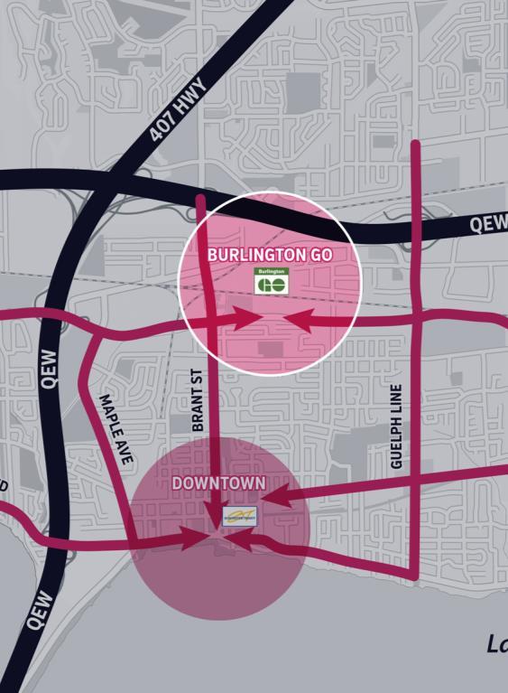
16 MTSA vs. Mobility Hub Major Transit Station Areas (MTSA) Mobility Hub (MH) City-Identified Mobility Hubs (MTSA/MH) City, Region, Provincial Land Use Planning Purposes Metrolinx Transit Planning and Investment Purposes City Land Use Planning and Investment Purposes Aldershot GO Burlington GO Appleby GO Downtown Burlington GO Downtown Aldershot GO Burlington GO Appleby GO Downtown

")
17 Regional Express Rail (RER)

18 Project Stages


19 Community Dialogue All GO Station Hubs Open houses Newspaper ads Direct mailings blasts Project website Online workbook Tweets Facebook ads Burlington Transit bus ads
20 Community and Council Dialogue Things to Keep in Mind The City is NOT expropriating land These are long term plans These plans are evolving Not all sites may be able to achieve the maximum building height These plans are not zoning


21 Objectives Near GO and Transit Corridors Minimize Shadows Height Transitions Future Public Service Facilities Variety of Housing Existing and Future Employment Draft Precinct Plans Active Transportation Connections Heritage Cultural Resources Attract Retail and Commercial Uses Improve Connectivity New Parks & Open Space


22 Draft Precinct Plans May 2018 ALDERSHOT GO BURLINGTON GO APPLEBY GO


23 Parks and Open Space Create a parks and open space network to serve residents and employees Maintain and enhance public access to parks and open spaces ALDERSHOT GO BURLINGTON GO APPLEBY GO


24 Public Service Accommodate current and future public services May accommodate public service uses wholly or as part of a public-private partnership ALDERSHOT GO BURLINGTON GO APPLEBY GO


25 GO Central Precincts Establishes a height peak within the GO Station Mobility Hubs Most significant area for residential, retail and commercial Pre-eminent destination for office, affordable housing and urban format retail ALDERSHOT GO BURLINGTON GO APPLEBY GO

 Accommodate a wide")

26 Mid-Rise Residential Precinct Support the development of compact urban residential communities low and/or mid-rise housing forms ( The Missing Middle ) Accommodate a wide range of demographics Transition to adjacent precincts and/or areas ALDERSHOT GO BURLINGTON GO APPLEBY GO
27 Things to Know about All Draft Precincts Not all sites may be able to achieve maximum height/density Heights are maximums inclusive of Community Benefits (Section 37) Transportation Demand Management (TDM) & traffic mitigation measures to be incorporated into all developments High degree of public realm and building design required Full suite of Technical Studies on-going

28 ALDERSHOT GO MOBILITY HUB Aldershot GO Mobility Hub

29 Aldershot GO Mobility Hub Area Hidden Valley Park Grove Park Aldershot Park Drewlo Apartments LaSalle Park Retirement Community
30 Aldershot GO Mobility Hub
31 Parks and Open Space Precinct Parks and Open Space Proposed Park < 1 Ha Proposed Park > 1 Ha Proposed Linear Park

32 Parks and Open Space Precinct Parks and Open Space Proposed Park < 1 Ha Proposed Park > 1 Ha Proposed Linear Park
33 Public Service Precinct Public Service Potential Location for Public Service
34 Public Service Precinct Public Service Potential Location for Public Service

35 Aldershot Main Street Precinct INTENTION STATEMENT Advance the Plains Road Village Vision Establish a unique community destination Create a continuous retail frontage with a main-street pedestrian experience * * * * * * Area of lower height maximum
")


36 Aldershot Main Street Precinct KEY DIRECTIONS Mid-rise form (5-11 storeys) with continuous building frontage Establish a minimum floor height for ground floor Require podium elements to enhance public realm and pedestrian environment Minimum of two uses

37 Grove Park/St. Matthew's Neighbourhood Precinct INTENTION STATEMENT Maintain low-rise residential and neighbourhood character Provide an effective and compatible transition to established neighbourhoods New and/or enhanced multi-modal connections Consistent with existing and adopted Official Plan permissions


38 Grove Park/St. Matthew's Neighbourhood Precinct KEY DIRECTIONS Provide for street-oriented townhouses Enhance existing streets to provide permeability Require built form and design measures to achieve effective transitions and compatibility

39 Mid-Rise Residential Precinct INTENTION STATEMENT Support the development of compact urban residential communities with a variety of low and/or mid-rise housing forms Accommodate a wide range of demographics Transition to adjacent precincts and/or areas
40 Mid-Rise Residential Precinct KEY DIRECTIONS Maximum 11 storeys in a mid-rise or low-rise form (inclusive of community benefits) Opportunities for commercial activity at the street Provide for a range of unit types and sizes

41 Emery/Cooke Commons Precinct INTENTION STATEMENT Concentration of residential, retail and commercial uses oriented around planned major public parks Ensure linkages to/from the frequent transit corridor Tall mixed-use buildings that will contribute to a people-oriented place
 Required podium for pedestrian scaled environment Provide")

42 Emery/Cooke Commons Precinct KEY DIRECTIONS Maximum 19 storeys (inclusive of community benefits) Required podium for pedestrian scaled environment Provide active transportation linkages to/from frequent transit corridor (Plains Rd. and Waterdown Rd.) Setbacks at street level for enhanced public realm Minimum of two uses

43 Aldershot GO Central Precinct INTENTION STATEMENT Height peak in close proximity to the rail and GO Stations Most significant area for residential, retail and commercial Pre-eminent destination for office, affordable housing and urban format retail
44 Aldershot GO Central Precinct KEY DIRECTIONS Maximum 30 storeys (inclusive of community benefits) Require retail, office and/or other service commercial uses at street level Setbacks at street level to enhance public realm Incorporate significant employment function Minimum of two uses
45 BURLINGTON GO MOBILITY HUB


46 Burlington GO Mobility Hub Area Drury Lane Pedestrian Bridge Staples/Mandarin Plaza Paradigm Development
47 Burlington GO Mobility Hub
48 Parks and Open Space Precinct Parks and Open Space Proposed Park < 1 Ha Proposed Park > 1 Ha

49 Parks and Open Space Precinct Parks and Open Space Proposed Park < 1 Ha Proposed Park > 1 Ha
50 Public Service Precinct Public Service Potential Location for Public Service
51 Public Service Precinct Public Service Potential Location for Public Service

52 Mid-Rise Residential Precinct INTENTION STATEMENT Support the development of compact urban residential communities with a variety of low and/or mid-rise housing forms Accommodate a wide range of demographics Transition to adjacent precincts and/or areas
53 Mid-Rise Residential Precinct KEY DIRECTIONS Maximum 11 storeys in a mid-rise or low-rise form (inclusive of community benefits) Opportunities for commercial activity at the street Provide for a range of unit types and sizes

54 Leighland Node Precinct INTENTION STATEMENT Intersection-focused mixed-use node Serve retail and commercial service needs of adjacent residential area Tall mixed-use buildings that frame the intersection of Plains Rd. and Brant St. with high degree of compatibility with adjacent residential area
55 Leighland Node Precinct KEY DIRECTIONS Maximum 19 storeys (inclusive of community benefits) Requirement for built form and design tools to achieve effective transition and high-degree of compatibility Required podium for pedestrian scaled environment Setbacks at street level to enhance public realm Minimum of two uses

56 Fairview/Brant Frequent Transit Corridor Precinct INTENTION STATEMENT Concentration of residential, retail and commercial uses oriented around planned major public parks Support the frequent transit corridor along Fairview St. and Brant St. Tall mixed-use buildings that will contribute to a people-oriented place
57 Fairview/Brant Frequent Transit Corridor Precinct KEY DIRECTIONS Maximum 19 storeys (inclusive of community benefits) Required podium for pedestrian scaled environment Provide active transportation linkages to and from frequent transit corridors (Fairview St. and Brant St.) Setbacks at street level to enhance public realm Minimum of two uses

58 Burlington GO Central Precinct INTENTION STATEMENT Height peak in close proximity to the rail and GO Station Key linkage to Burlington s Urban Growth Centre/Downtown Mobility Hub Most significant area for residential, retail and commercial Pre-eminent destination for office, affordable housing and urban format retail
59 Burlington GO Central Precinct KEY DIRECTIONS Maximum 30 storeys (inclusive of community benefits) Require retail, office and/or other service commercial uses at street level Setbacks at street level to allow for amenities to enhance public realm Incorporate significant employment function within mixed use developments Minimum of two uses
 Retail and service commercial uses to serve employees")
60 Urban Employment Precinct INTENTION STATEMENT Provide opportunities for employment uses in a compact built form along major transportation corridors Prestige employment uses (i.e. offices, R&D, information technology, etc.) Retail and service commercial uses to serve employees
61 Urban Employment Precinct KEY DIRECTIONS Establish high design and development standards Permit opportunities for small scale retail/commercial at grade
62 APPLEBY GO MOBILITY HUB

63 Appleby GO Mobility Hub Area Appleview Square
64 Appleby GO Mobility Hub
65 Parks and Open Space Precinct Parks and Open Space Proposed Park < 1 Ha Proposed Park > 1 Ha Proposed Linear Park

66 Parks and Open Space Precinct Parks and Open Space Proposed Park < 1 Ha Proposed Park > 1 Ha Proposed Linear Park
67 Public Service Precinct Public Service Potential Location for Public Service

68 Public Service Precinct Public Service Potential Location for Public Service

69 Mid-Rise Residential Precinct INTENTION STATEMENT Support the development of compact urban residential communities with a variety of low and/or mid-rise housing forms Accommodate a wide range of demographics Transition to adjacent precincts and/or areas
70 Mid-Rise Residential Precinct KEY DIRECTIONS Maximum 11 storeys in a mid-rise or low-rise form (inclusive of community benefits) Opportunities for commercial activity at the street Provide for a range of unit types and sizes

71 Fairview Frequent Transit Corridor Precinct INTENTION STATEMENT Concentration of residential, retail and commercial uses along the planned frequent transit corridor Tall mixed-use buildings that will contribute towards the creation of a lively, vibrant and people-oriented place
72 Fairview Frequent Transit Corridor Precinct KEY DIRECTIONS Maximum 19 storeys (inclusive of community benefits) Required podium for pedestrian scaled environment Provide active transportation linkages to and from frequent transit corridor (Fairview St.) Setbacks at street level to allow for amenities to enhance public realm Minimum of two uses

73 Appleby GO Central Precinct INTENTION STATEMENT Concentration of residential, retail and commercial in close proximity to the rail and GO Station Pre-eminent destination for office, affordable housing and urban format retail Contribute to a complete, transit-oriented community High degree of compatibility with adjacent land uses
74 Appleby GO Central Precinct KEY DIRECTIONS Maximum 30 storeys (inclusive of community benefits) Require retail, office and/or other service commercial uses at street level Setbacks at street level to enhance public realm Incorporate significant employment function within Minimum of two uses
 Retail and service commercial uses to serve employees")
75 Urban Employment Precinct INTENTION STATEMENT Provide opportunities for employment uses in a compact built form along major transportation corridors Prestige employment uses (i.e. offices, R&D, information technology, etc.) Retail and service commercial uses to serve employees


76 Urban Employment Precinct KEY DIRECTIONS Establish high design and development standards Permit opportunities for small scale retail/commercial at grade

77 General Employment INTENTION STATEMENT Provide opportunities for a broad range of employment uses such as light industrial and offices


78 General Employment KEY DIRECTIONS Limit outdoor storage and activities to achieve higher degree of compatibility with surrounding uses
79 Important On-Going Considerations for the Mobility Hub

 may")
80 Public Parks & Open Spaces Parks are integral to making the mobility hubs healthy, active and livable neighbourhoods Physical dedication of public parks and/or open spaces (instead of cashin-lieu) will be a priority Precinct plans identify strategic urban park locations developed with Parks and Open Space section Other parks and/or open spaces (not on the precinct plan) may be required


81 Compatibility Compatibility with Existing Neighbourhoods Compatibility with Existing and Future Industry and Transportation Infrastructure


82 Transportation Each hub will incorporate new streets and active transportation connections to: o increase pedestrian, cycling, transit and vehicular permeability o create new development opportunities o provide alternative transportation routes within, to and from the hubs to mitigate traffic congestion Transportation measures for the hubs are focused on mitigation of traffic congestion

83 Employment Uses / Jobs Preliminary target is a 2:1 ratio of residents to jobs within each hub (subject to on-going assessment) Employment uses accommodated through: o employment only precincts; and/or o requirements for employment only floor space in mixed use developments Proportional requirement: the greater the height/density permitted in a precinct the greater the employment floor space required
84 Next Steps and Timelines 2018 Area Specific Plan Development and Further Public Engagement 2019 Present Final Mobility Hub Area Specific Plans to City Council 2019/2020 Implementation (Region coordination, zoning, design guidelines etc.)
85 Purpose of this Workshop Present Draft Precinct Plans for the 3 GO Station Mobility Hubs Continue the conversations that began with the public in May 2018 Discuss precincts and their key policy directions Collect feedback to be used as a key input into the Area Specific Plans
SUBJECT: GO Station Mobility Hubs Preferred Concepts: Aldershot GO, Burlington GO and Appleby GO. Planning and Development Committee - Public Meeting
 Page 1 of Report PB-76-17 SUBJECT: GO Station Mobility Hubs Preferred Concepts: Aldershot GO, Burlington GO and Appleby GO TO: FROM: Planning and Development Committee - Public Meeting Planning and Building
burlington mobility hubs study Downtown Burlington Mobility Hub
 burlington mobility hubs study Downtown Burlington Mobility Hub Draft Precinct Plan Workbook PIC #3, September 7, 2017 downtown mobility hub objectives City staff and their consultants are proposing an
WELCOME and introduction
 1 WELCOME and introduction Mobility Hub Locations within Burlington STUDY OVERVIEW STUDY OBJECTIVES The City of Burlington is developing four Area Specific Plans, one for each of Burlington s Mobility
SUBJECT: Proposed Downtown Mobility Hub Precinct Plan and Proposed Official Plan Policies
 Page 1 of Report PB-81-17 SUBJECT: Proposed Downtown Mobility Hub Precinct Plan and Proposed Official Plan Policies TO: FROM: Committee of the Whole Planning and Building Department Report Number: PB-81-17
Aldershot GO Draft Mobility Hub Concepts. East Plains United Church September 13, :30 8:30 pm
 Aldershot GO Draft Mobility Hub Concepts East Plains United Church September 13, 2017 6:30 8:30 pm Today s Agenda 6:30pm: 6:35pm: 7:10pm: 8:10pm: 8:25pm: Opening Remarks Rosa Bustamante, Manager Mobility
Urban Design Manual PLANNING AROUND RAPID TRANSIT STATIONS (PARTS) Introduction. Station Study Areas
 Introduction. Station Study Areas") 111111 PLANNING AROUND RAPID TRANSIT STATIONS (PARTS) Introduction The ION rapid transit system will link Waterloo, Kitchener and Cambridge through a central transit corridor (CTC). There are a number
111111 PLANNING AROUND RAPID TRANSIT STATIONS (PARTS) Introduction The ION rapid transit system will link Waterloo, Kitchener and Cambridge through a central transit corridor (CTC). There are a number
Trafalgar Road Corridor Planning Study Open House
 Trafalgar Road Corridor Planning Study Open House June 24, 2013 6:30-8:30 p.m. Oakville & Trafalgar Rooms Overview The Livable Oakville Plan identifies the lands along Trafalgar Road, between the QEW and
Create Policy Options Draft Plan Plan Approval. Public Consultation Events. Phase 2
 Background Grandview-Woodland Community Plan In the spring of 2012, the City of Vancouver embarked on a comprehensive community planning program in the Grandview-Woodland neighbourhood. The process has
CDAC. Update: Downtown Dartmouth Update: CDAC July 25 th Motion
 CDAC Update: Downtown Dartmouth Update: CDAC July 25 th Motion 2018-10-24 Downtown Dartmouth Plan Open House October 22, 2018 6:00 pm Open House 6:30 pm Presentation + Q&A 7:20 pm Open House 8:30 pm Close
The Master Plan Framework
 The Master Plan Framework The East Harbour Master Plan advances the development of 60 acres of former industrial lands east of the Don River. The Master Plan outlines a vision for a vibrant, transit-oriented
Land Use Policies Urban Area. Land Use Policies Urban Area
 8 Land Use Policies Urban Area Land Use Policies Urban Area LAND USE POLICIES URBAN AREA 8.1 MIXED USE INTENSIFICATION AREAS... 8-5 8.1.1 URBAN CENTRES... 8-5 8.1.1(3) DOWNTOWN URBAN CENTRE... 8-9 8.1.1(4)
Workshop 3. City of Burlington Waterfront Hotel Planning Study. September 14, The Planning Partnership
 Workshop 3 City of Burlington Waterfront Hotel Planning Study September 14, 2017 The Planning Partnership The Waterfront Hotel Planning Study 01 The Brant & Lakeshore Planning Study will establish a Strategic
Land Use Policies Urban Area. Land Use Policies Urban Area
 8 Land Use Policies Urban Area Land Use Policies Urban Area This page has been left intentionally blank LAND USE POLICIES URBAN AREA 8.1 MIXED USE INTENSIFICATION AREAS... 8-5 8.1.1 URBAN CENTRES... 8-5
Sustainable Growth. Sustainable Growth
 2 Sustainable Growth Sustainable Growth SUSTAINABLE GROWTH 2.1 COMMUNITY VISION... 2-5 2.2 THE CITY SYSTEM... 2-7 2.2.1 AREAS... 2-7 2.2.2 CITY-WIDE SYSTEMS... 2-8 2.2.3 PROVINCIAL PLAN BOUNDARIES AND
SCARBOROUGH SUBWAY EXTENSION. Scarborough Subway Extension. Final Terms of Reference
 Scarborough Subway Extension Final Terms of Reference 1 1.0 Introduction and Background 1.1 Introduction Toronto City Council recently confirmed support for an extension of the Bloor-Danforth Subway from
SUBJECT: Supplementary Information and Directions Regarding the Proposed Downtown Mobility Hub Precinct Plan and Proposed Official Plan Policies
 Page 1 of Report PB-11-18 SUBJECT: Supplementary Information and Directions Regarding the Proposed Downtown Mobility Hub Precinct Plan and Proposed Official Plan Policies TO: FROM: Planning and Development
ELMVALE ACRES SHOPPING CENTRE MASTER PLAN
 ELMVALE ACRES SHOPPING CENTRE MASTER PLAN Contents 1.0 INTRODUCTION... 2 2.0 LOCATION... 2 3.0 EXISTING CONTEXT... 2 4.0 VISION & GUIDING PRINCIPLES... 2 5.0 LAND USE AND BUILT FORM... 4 5.1 St. Laurent
SUBJECT: Waterfront Hotel Planning Study Update TO: Planning and Development Committee FROM: Department of City Building. Recommendation: Purpose:
 Page 1 of Report PB-23-18 SUBJECT: Waterfront Hotel Planning Study Update TO: Planning and Development Committee FROM: Department of City Building Report Number: PB-23-18 Wards Affected: 2 File Numbers:
PUBLIC OPEN HOUSE HURONTARIO-MAIN CORRIDOR SECONDARY PLAN
 PUBLIC OPEN HOUSE HURONTARIO-MAIN CORRIDOR SECONDARY PLAN Tuesday, February 28, 2012 6pm 9pm 1 st Floor Atrium, City Hall 2 Wellington Street West, Brampton 1 POLICY FRAMEWORK The 2006 Provincial Growth
PILLAR FOUR INTEGRATE LAND USE & TRANSPORTATION
 PILLAR FOUR INTEGRATE LAND USE & TRANSPORTATION 8 Scarborough Centre on the Move Transportation Master Plan 123 8 Transportation Pillar Four Integrate Land Use & The fourth pillar focuses on the relationship
1.3 TRANSIT VISION 2040 FROM VISION TO ACTION THEME 1: PUTTING TRANSIT AT THE CENTRE OF COMMUNITIES. Fully integrate transit with community planning
 TRANSIT VISION 2040 FROM VISION TO ACTION TRANSIT VISION 2040 defines a future in which public transit maximizes its contribution to quality of life with benefits that support a vibrant and equitable society,
Speers Road Corridor Study. Livable Oakville (Official Plan) Council Sub Committee March 20, 2017
 Council Sub Committee March 20, 2017") Speers Road Corridor Study Livable Oakville (Official Plan) Council Sub Committee March 20, 2017 Overview 1) Study Purpose & Background 2) Study Area 3) Policy Context and Plan Review 4) Speers Road Corridor
Speers Road Corridor Study Livable Oakville (Official Plan) Council Sub Committee March 20, 2017 Overview 1) Study Purpose & Background 2) Study Area 3) Policy Context and Plan Review 4) Speers Road Corridor
THE CITY OF VAUGHAN BY-LAW BY-LAW NUMBER A By-law to adopt Amendment Number 1 to the Official Plan of the Vaughan Planning Area.
 THE CITY OF VAUGHAN BY-LAW BY-LAW NUMBER 015-2014 A By-law to adopt Amendment Number 1 to the Official Plan of the Vaughan Planning Area. NOW THEREFORE the Council of the Corporation of the City of Vaughan
King-Spadina Secondary Plan Community Consultation Meeting. Michelle Knieriem, City Planner October 11, 2017
 King-Spadina Secondary Plan Community Consultation Meeting Michelle Knieriem, City Planner October 11, 2017 Agenda 6:30 Welcome 6:35 Presentation 7:15 Question and Answer Session 8:15 Closing Remarks HOW
Mark-up of the effect of the proposed Bronte Village Growth Area OPA No.18 on the text of section 24, Bronte Village, of the Livable Oakville Plan
 Mark-up of the effect of the proposed Bronte Village Growth Area OPA No.18 on the text of section 24, Bronte Village, of the Livable Oakville Plan Notes: This document is provided for information purposes
Welcome to the Oakridge Centre Open House
 Welcome to the Oakridge Centre Open House Why is the City hosting this event? This open house is to inform you of a rezoning application submitted to the City of Vancouver to amend the existing CD-1 (Comprehensive
Niagara GO Hub and Transit Stations Study
 Niagara GO Hub and Transit Stations Study Public Open House #2 June 2017 Study Purpose The purpose of this study is to prepare four key deliverables for each station area: 1. Work with Metrolinx to provide
The West Vaughan Employment Area Secondary Plan Policies
 Part 2: The West Vaughan Employment Area Secondary Plan Policies 2.1 General Policies It is the policy of Council: 2.1.1. That the West Vaughan Employment Area (the WVEA), identified on Schedule 1, will
Town Center (part of the Comprehensive Plan)
") Town Center (part of the Comprehensive Plan) Mercer Island Town Center Looking North (2014) In 1994, a year-long process culminated in a set of design guidelines and code requirements for the Town Center
Town Center (part of the Comprehensive Plan) Mercer Island Town Center Looking North (2014) In 1994, a year-long process culminated in a set of design guidelines and code requirements for the Town Center
Official Plan Review
 Official Plan Review Summary Report - The Built Environment August 2014 Part 1: Introduction Planning for a healthy, prosperous and sustainable community is an important goal for our municipality. From
1.0 Purpose of a Secondary Plan for the Masonville Transit Village
 Report to Planning and Environment Committee To: Chair and Members Planning & Environment Committee From: John M. Fleming Managing Director, Planning and City Planner Subject: Masonville Transit Village
3. Urban Design in the Central Area
 3. Urban Design in the Central Area The Central Area Planning and Design Group assumes the responsibility to promote high quality urban and architectural design in the Central Area, plan and ensure the
Official Plan Review: Draft Built Form Policies
 PG.30.1 REPORT FOR ACTION Official Plan Review: Draft Built Form Policies Date: May 15, 2018 To: Planning and Growth Management Committee From: Chief Planner and Executive Director, City Planning Division
Agincourt Mall Planning Framework Review Status Report
 STAFF REPORT ACTION REQUIRED Agincourt Mall Planning Framework Review Status Report Date: May 16, 2018 To: From: Scarborough Community Council Director, Community Planning, Scarborough District Wards:
Public Open House. Yonge Street and Bernard Avenue (Bernard KDA) Planning Study Update Town of Richmond Hill. March 30, 2017
 Planning Study Update Town of Richmond Hill. March 30, 2017") Public Open House Yonge Street and Bernard Avenue (Bernard KDA) Planning Study Update Town of Richmond Hill March 30, 2017 Open House Review of Project Purpose and Process Policy Refresher Highlights of
Public Open House Yonge Street and Bernard Avenue (Bernard KDA) Planning Study Update Town of Richmond Hill March 30, 2017 Open House Review of Project Purpose and Process Policy Refresher Highlights of
DOWNTOWN GEORGETOWN PLANNING STUDY
 DOWNTOWN GEORGETOWN PLANNING STUDY Community Workshop #3 Thursday, May 4, 08 The Planning Partnership OVERVIEW OF STUDY, PROCESS & MILESTONES We are here PURPOSE OF THE STUDY To develop a clear vision
Regency Developments. Urban Design Brief. Holyrood DC2 Rezoning
 Regency Developments Urban Design Brief Holyrood DC2 Rezoning Stantec Consulting Ltd. 7-31-2017 1. Overview Regency Developments intends to rezone the lands located at 8510 and 8511 93 Avenue, within the
Draft Urban Hamilton Official Plan. Amendment No. XX
 1 of 75 The following text, together with: Draft Appendix A Appendix B Volume 1, Schedule E-1 Urban Land Use Designations Appendix C Volume 1, Appendix A Parks Classification Map Appendix D Volume 1, Appendix
Town of Cobourg Heritage Master Plan. Statutory Public Meeting
 Town of Cobourg Heritage Master Plan Statutory Public Meeting April 25 th 2016 Presentation Overview 1. Introduction 2. Project background and schedule overview 3. Review of strategic direction content
Complete Neighbourhood Guidelines Review Tool
 Complete Neighbourhood Guidelines Review Tool Prepared By: City of Regina Planning Department October 2014 Page 1 of 14 Community Development Review Checklist for Secondary Plans and Concept Plans The
SUBJECT: Revised proposed new official plan recommended for adoption
 Page 1 of Report PB-04-18 SUBJECT: Revised proposed new official plan recommended for adoption TO: FROM: Planning and Development Committee Department of City Building Report Number: PB-04-18 Wards Affected:
MOUNT PLEASANT SECONDARY PLAN & VILLAGE BLOCK PLAN. Wednesday, March 5, 2008 Informal Public Open House
 MOUNT PLEASANT SECONDARY PLAN & VILLAGE BLOCK PLAN Wednesday, March 5, 2008 Informal Public Open House 1. Welcome & Introductions 2. Highlights of Provincial Growth Plan 3. Overview and Status Update -
WELCOME. The Yonge-Eglinton area has experienced significant growth and change in the last decade.
 WELCOME DID YOU KNOW? MIDTOWN IS REPRESENTED BY 3 CITY COUNCILLORS: WARD 16 EGLINTON-LAWRENCE WARD 22 ST. PAUL S WARD 25 DON VALLEY WEST Midtown in Focus: Building a Livable Yonge-Eglinton The Yonge-Eglinton
Don Mills Crossing Study and Celestica Lands Development Application Community Meeting, Open House, and Breakout Discussions
 Consultation Summary Don Mills Crossing Study and Celestica Lands Development Application Community Meeting, Open House, and Breakout Discussions This report is not intended to provide a verbatim transcript
McCowan Precinct Plan Study Background & Deliverables
 1 DRAFT & WITHOUT PREJUDICE McCowan Precinct Plan Study Background & Deliverables In September, 2011, City Planning (Scarborough District) began a study of an area within the Scarborough Centre, identified
*** DRAFT 2 FOR PUBLIC REVIEW ***
 6.7 The area is generally bounded by the Red Hill Valley Parkway to the west, Lake Avenue to the east, the Queen Elizabeth Way (QEW) to the north, and by the properties just south of Queenston Road to
Employment and Commercial Review Analysis of Policy Directions
 Employment and Commercial Review Analysis of Policy Directions Appendix A The following analysis is town staff s response to the policy directions provided by the consultants who prepared the Employment
Figure 1- Site Plan Concept
 Figure 1- Site Plan Concept Parking will be provided underground on three levels at rate of 1.0 space/ unit; this rate includes all visitors parking. MMM Group has prepared a parking assessment (April,
GOLDEN MILE SECONDARY PLAN. Community Consultation Meeting #3 June 26, 2018
 GOLDEN MILE SECONDARY PLAN Community Consultation Meeting #3 June 26, 2018 Meeting Overview 1. Introduction 2. Principles + Vision 3. Street + Block Alternatives 4. Parks + Open Space Alternatives 5. Land
NEW REGIONAL OFFICIAL PLAN HIGH LEVEL PROCESS & FRAMEWORK
 NEW REGIONAL OFFICIAL PLAN HIGH LEVEL PROCESS & FRAMEWORK Why A New Official Plan Originally the role of Regionally Planning and content of Regional Official Plan (1970s) primarily focused on protecting
POLICY AMENDMENT AND LAND USE AMENDMENT TUXEDO PARK (WARD 9) CENTRE STREET N AND 26 AVENUE NE BYLAWS 36P2017 AND 234D2017
 CENTRE STREET N AND 26 AVENUE NE BYLAWS 36P2017 AND 234D2017") Page 1 of 11 EXECUTIVE SUMMARY This application proposes to redesignate a single parcel of land in the Community of Tuxedo Park from Commercial Corridor 2 (C-COR2 f1h10) District to Mixed Use Active Frontage
Page 1 of 11 EXECUTIVE SUMMARY This application proposes to redesignate a single parcel of land in the Community of Tuxedo Park from Commercial Corridor 2 (C-COR2 f1h10) District to Mixed Use Active Frontage
3. Endorse the LRT vision in transforming Surrey into Connected-Complete-Livable communities, and more specifically, the official vision statement:
 CORPORATE REPORT NO: R038 COUNCIL DATE: February 20, 2017 REGULAR COUNCIL TO: Mayor & Council DATE: February 16, 2017 FROM: General Manager, Engineering FILE: 8740-01 SUBJECT: Surrey Light Rail Transit
Edward R. Sajecki Commissioner of Planning and Building
 Corporate Report Clerk s Files Originator s Files CD.03.POR DATE: TO: FROM: SUBJECT: Chair and Members of Planning and Development Committee Meeting Date: February 27, 2012 Edward R. Sajecki Commissioner
SECTION ONE: INTRODUCTION. introduction
 introduction 1 INTRODUCTION Since it was first established in 1843 as a trading post for the Hudson s Bay Company, Victoria has evolved into a Provincial capital city that is recognized across Canada and
Building out the Regional Growth Strategy in Surrey: a Strong Centre & a Connected Transit City
 Building out the Regional Growth Strategy in Surrey: a Strong Centre & a Connected Transit City Surrey in the Metro Vancouver Region Regional Growth Strategy identifies Surrey as a major provider of housing
Agenda. 7 Wright Crescent Urban Design Study. Public Meeting and Urban Design Workshop. 1 INTRODUCTION AND BACKGROUND (City of Kingston)
") Urban Design Study Public Meeting and Urban Design Workshop October 02, 2013 Agenda 1 INTRODUCTION AND BACKGROUND (City of Kingston) 2 URBAN DESIGN STUDY PRESENTATION (Antonio Gomez-Palacio, DIALOG) 3
Urban Design Study Public Meeting and Urban Design Workshop October 02, 2013 Agenda 1 INTRODUCTION AND BACKGROUND (City of Kingston) 2 URBAN DESIGN STUDY PRESENTATION (Antonio Gomez-Palacio, DIALOG) 3
[PLANNING RATIONALE] For Site Plan Control and Lifting of Holding Zone By-Law 101 Champagne Avenue. May 23, 2014
![[PLANNING RATIONALE] For Site Plan Control and Lifting of Holding Zone By-Law 101 Champagne Avenue. May 23, 2014](/thumbs/75/71599615.jpg "[PLANNING RATIONALE] For Site Plan Control and Lifting of Holding Zone By-Law 101 Champagne Avenue. May 23, 2014") [PLANNING RATIONALE] For Site Plan Control and Lifting of Holding Zone By-Law 101 Champagne Avenue May 23, 2014 Contents 1.0 Introduction... 2 2.0 Site Context... 2 2.1 Adjacent Uses... 2 Figure 1: Site
[PLANNING RATIONALE] For Site Plan Control and Lifting of Holding Zone By-Law 101 Champagne Avenue May 23, 2014 Contents 1.0 Introduction... 2 2.0 Site Context... 2 2.1 Adjacent Uses... 2 Figure 1: Site
Welcome. Walk Around. Talk to Us. Write Down Your Comments
 Welcome This is an information meeting introducing the applications for proposed redevelopment of the Yorkdale Shopping Centre site at 3401 Dufferin Street and 1 Yorkdale Road over the next 20+ years,
Key Themes and Responses May 2016
 King and Victoria Transit Hub and Waterloo Street Pedestrian Access Key Themes and Responses May 2016 The following summarizes what Regional staff heard about the King Victoria Transit Hub and Waterloo
Cambie Corridor Planning Program Phase Two Draft Plan. Standing Committee on City Services and Budgets May 5, 2011
 Cambie Corridor Planning Program Phase Two Draft Plan Standing Committee on City Services and Budgets May 5, 2011 Cambie Corridor Program Terms of Reference approved July 2009 Land Use Transportation Energy
Corridor Vision. 1Pursue Minnehaha-Hiawatha Community Works Project. Mission of Hennepin County Community Works Program
 1Pursue Minnehaha-Hiawatha Community Works Project Minnehaha-Hiawatha Community Works is a project within the Hennepin Community Works (HCW) program. The mission of the HCW program is to enhance how the
REVIEW AND EVALUATION OF REGIONAL LAND USE
 REVIEW AND EVALUATION OF REGIONAL LAND USE AND TRANSPORTATION SCENARIOS #220831 Environmental Justice Task Force October 7, 2014 VISION 2050 Process Development of Guiding Vision for Land Use and Transportation
City of Burlington Official Plan Review Commercial Strategy Study
 Appendix A to Report PB-09-14 City of Burlington Official Plan Review Commercial Strategy Study Phase 2: Commercial Policy Recommendations Report & Commercial Design Guidelines March 6, 2014 Page left
Port Credit Local Advisory Panel October 20 th Meeting
 Port Credit Local Advisory Panel October 20 th Meeting Focus Of This Evening s Meeting: 1. Hurontario Main Street Higher Order Transit Study 2. Port Credit Mobility Hub & GO Station Parking Structure Study
Clairtrell Area Context Plan
 Clairtrell Area Context Plan March 2005 Urban Development Services City Planning Contents 1. Introduction... 4 2. Development Structure... 6 2.1 Streets... 7 2.1.1 Sheppard Avenue and Bayview Avenue...
University of Saskatchewan CAMPUS MASTER PLAN. Senate Meeting Preliminary Presentation. April 21, 2018 DIALOG ECS DA WATT
 University of Saskatchewan CAMPUS MASTER PLAN Senate Meeting Preliminary Presentation April 21, 2018 DIALOG ECS DA WATT project process presentation agenda Stakeholder Engagement Project Control phase1
THE GARDEN CITY PLAN. City of St. Catharines Official Plan. City of St. Catharines
 THE GARDEN CITY PLAN City of St. Catharines Official Plan City of St. Catharines August 2010 APPROVAL INFORMATION This Official Plan of the City of St. Catharines Planning Area, known as the Garden City
East Bayshore Road Neighbourhood
 East Bayshore Road Neighbourhood Northridge Property Management Urban Design Brief 3195 East Bayshore Road City of Owen Sound January 2016 East Bayshore Road Neighbourhood Northridge Property Management
Burlington s Strategic Plan
 Burlington s Strategic Plan 2015 2040 DRAFT FOR CONSULTATION burlington.ca/strategicplan Welcome to Burlington s 2015 2040 Strategic Plan The City of Burlington s 2015-2040 Strategic Plan is the result
ORANGE LINE TRANSIT NEIGHBORHOOD PLANS VAN NUYS NEIGHBORHOOD COUNCIL, PLUM COMMITTEE DEPARTMENT OF CITY PLANNING, CITY OF LOS ANGELES
 Photo: Mission Meridian(Moule & Polyzoides) ORANGE LINE TRANSIT NEIGHBORHOOD PLANS VAN NUYS NEIGHBORHOOD COUNCIL, PLUM COMMITTEE DEPARTMENT OF CITY PLANNING, CITY OF LOS ANGELES JULY 18, 2018 Project partially
Urban Design Brief. Watson Parkway North & Watson Road North Guelph, Ontario. Prepared by Coletara Development
 Urban Design Brief Watson Parkway North & Watson Road North Guelph, Ontario Prepared by Coletara Development December, 2013 Urban Design Brief, Coletara Development 1 Introduction This Urban Design Brief
Laird in Focus Community Information Session
 Laird in Focus Community Information Session Tuesday, December 5, 2017 St. Anslem Catholic School, 182 Bessborough Drive Session 1: 5:30 pm - Presentation and Question and Answer Period 6:15 pm - Breakout
Public Consultation Summary: Lakeview Place Making Workshop January 30, 2008.
 Page 1 of 11 Public Consultation Summary: Lakeview Place Making Workshop January 30, 2008. 1.0 Introduction: On January 30, 2008 the City of Mississauga, in conjunction with the consulting team of Brook
Public Open House. Overview of the Downtown Plan Official Plan Amendment April 23, 2018
 Public Open House Overview of the Downtown Plan Official Plan Amendment April 23, 2018 1 A 25-Year Plan for Downtown To ensure growth contributes positively to Toronto s Downtown as a great place to live,
Plano Tomorrow Vision and Policies
 Plano Tomorrow Vision and Policies PLANO TOMORROW PILLARS The Built Environment The Social Environment The Natural Environment The Economic Environment Land Use and Urban Design Transportation Housing
178 Carruthers Properties Inc.
 178 Carruthers Properties Inc. Planning Rationale for 178 Carruthers Avenue Site Plan Control Application June 2014 Table of Contents 1.0 Introduction 2.0 Overview of Subject Property 3.0 Current Zoning
PLAN ELEMENTS WORKSHOP. April 5, 2016
 PLAN ELEMENTS WORKSHOP April 5, 2016 needs more housing. But there is no one-size fits-all solution. Every neighborhood has its own character. In some places, density is not only appropriate it is badly
Crofton Manor 2803 West 41st Avenue WHAT WE HEARD. Public Consultation: Phase 1
 Crofton Manor 2803 West 41st Avenue WHAT WE HEARD Public Consultation: Phase 1 Background CROFTON MANOR What s Happening The City of Vancouver is undertaking a planning and public engagement process to
CONTENTS 2.0 A FRAMEWORK FOR SUSTAINABLE GROWTH 2.1 MANAGING SUSTAINABLE GROWTH THE VISION TO GOALS AND OBJECTIVES 2.3 MARKHAM STRUCTURE
 2 A Framework for Sustainable Growth 2.0 A FRAMEWORK FOR SUSTAINABLE GROWTH CONTENTS 2.1 MANAGING SUSTAINABLE GROWTH THE VISION TO 2031 2.2 GOALS AND OBJECTIVES 2.2.1 Protecting the Natural Environment
2.0 A FRAMEWORK FOR SUSTAINABLE GROWTH CONTENTS
 2-2 A Framework for Sustainable Growth 2.0 A FRAMEWORK FOR SUSTAINABLE GROWTH CONTENTS 2.1 MANAGING SUSTAINABLE GROWTH THE VISION TO 2031 2.2 GOALS AND OBJECTIVES 2.2.1 Protecting the Natural Environment
4- PA - LD - LIVELY DOWNTOWN. LD - Background
 4- PA - LD - LIVELY DOWNTOWN LD - Background The downtown has been the service centre for the community since the city s inception and the area continues to supply people with their personal services,
Downtown Streetscape Manual & Built Form Standards
 City of Guelph Downtown Streetscape Manual & Built Form Standards July 2014 Prepared by Brook McIlroy Inc. in association with Unterman McPhail Associates and McCormick Rankin Inc. City of Guelph Downtown
YONGE STEELES CORRIDOR SECONDARY PLAN. Young + Wright / IBI Group Architects Dillon Consulting Ltd. GHK International (Canada) Ltd.
 Ltd.") PART A: PREAMBLE 1.0 PURPOSE The purpose of this Secondary Plan is to provide a development framework for intensification of the Yonge/ Steeles corridor including the north side of Steeles Avenue West
PART A: PREAMBLE 1.0 PURPOSE The purpose of this Secondary Plan is to provide a development framework for intensification of the Yonge/ Steeles corridor including the north side of Steeles Avenue West
13 THORNHILL YONGE STREET STUDY IMPLEMENTATION CITY OF VAUGHAN OPA 669 AND TOWN OF MARKHAM OPA 154
 13 THORNHILL YONGE STREET STUDY IMPLEMENTATION CITY OF VAUGHAN OPA 669 AND TOWN OF MARKHAM OPA 154 The Planning and Economic Development Committee recommends the adoption of the recommendations contained
PUBLIC MEETING AND OPEN HOUSE: Don Mills Crossing Phase 2 Celestica Development Applications. February 21, 2017
 PUBLIC MEETING AND OPEN HOUSE: Don Mills Crossing Phase 2 Celestica Development Applications February 21, 2017 PURPOSE OF TONIGHT S MEETING Engage the community on the Don Mills Crossing Study and development
THE GREEN VISION WORKSHOP Friday, November 6, 2009
 THE GREEN VISION WORKSHOP Friday, November 6, 2009 SUSTAINABLE LONG RANGE PLANNING IN SANTA MONICA Eileen Fogarty Director, Planning and Community Development GREEN BUILDINGS Santa Monica has the most
1071 King Street West Zoning Amendment Application - Preliminary Report
 STAFF REPORT ACTION REQUIRED 1071 King Street West Zoning Amendment Application - Preliminary Report Date: August 9, 2012 To: From: Wards: Reference Number: Toronto and East York Community Council Director,
Moody Centre Station TOD Area Today
 Moody Centre Station TOD Area Today WHAT IS a transit-oriented Murray Street development area? A Transit-Oriented Development (TOD) Area is a dense, walkable residential and commercial area built to support
The Cambie Corridor 2015 Fall workshop series. What we heard WORKSHOP OUTLINE
 The Cambie Corridor 2015 Fall workshop series W 16 AVE Area 5 CAMBIE CORRIDOR Phase 3 What we heard ovember 21, 2015, 9am-noon, 1:30-4:30pm Peretz Centre 89 Participants* WORKSHOP OUTLIE Introductions
Plan Framework Report. Attachment A
 Plan Framework Report Attachment A Uptown-Douglas Corridor Plan - Plan Framework Report Contents Introduction... 1 Planning Process... 3 Project Objectives... 4 Vision... 5 Community Values... 6 Structural
Tremaine Dundas Secondary Plan (Draft May 2017)
") PB-52-17 Appendix A Tremaine Dundas Secondary Plan (Draft May 2017) Page 2 Tremaine Dundas Secondary Plan (Draft May 2017) This page has been left blank intentionally Page 3 Tremaine Dundas Secondary Plan
PB-52-17 Appendix A Tremaine Dundas Secondary Plan (Draft May 2017) Page 2 Tremaine Dundas Secondary Plan (Draft May 2017) This page has been left blank intentionally Page 3 Tremaine Dundas Secondary Plan
CITY OF VAUGHAN KIRBY GO TRANSIT HUB SUB-STUDY
 WELCOME! Thank you for attending, and welcome to the first of three Public Meetings for the Kirby GO Transit Hub Study. Your feedback is important to us, and will help inform the development of the draft
5 TOWN OF MARKHAM OFFICIAL PLAN AMENDMENT NO. 144 MILLIKEN MAIN STREET SECONDARY PLAN
 5 TOWN OF MARKHAM OFFICIAL PLAN AMENDMENT NO. 144 MILLIKEN MAIN STREET SECONDARY PLAN The Planning and Economic Development Committee recommends the following: 1. The communication from Brendan O Callaghan,
CHAPTER 5: GUIDING PRINCIPLES
 CHAPTER 5: GUIDING PRINCIPLES The following 10 principles were developed based on public consultation, planning policy and the background analysis conducted during Phase 1. The Guiding Principles significantly
Transportation. Strategies for Action
 Transportation A major priority for the Overlake Neighborhood is to develop a multimodal transportation system. To achieve this system, a balance has to be found among travel, circulation and access needs;
Hurontario/Main Street Corridor Master Plan Mississauga and Brampton Building a new and integrated vision for the corridor
 Hurontario/Main Street Corridor Master Plan Mississauga and Brampton Building a new and integrated vision for the corridor Martin Powell, Commissioner of Transportation and Works, City of Mississauga Paper
ELK GROVE GENERAL PLAN VISION
 2-1 CHAPTER 2: 2-2 CREATING OUR The Community Vision for Elk Grove, expressed through a Vision Statement and a series of Supporting Principles, is a declaration of the kind of community that Elk Grove
Getting and Giving the Most
 Getting and Giving the Most It s OUR meeting participate enthusiastically Focus on the future Terminology expertise is secondary There is such a thing as a bad idea! Respect (for each other and the process)
770 Don Mills Road and 805 Don Mills Road - Official Plan Amendment and Zoning By-law Amendment Application Preliminary Report
 REPORT FOR ACTION 770 Don Mills Road and 805 Don Mills Road - Official Plan Amendment and Zoning By-law Amendment Application Preliminary Report Date: To: From: Wards: June 22, 2018 North York Community
Land Use Amendment in Southwood (Ward 11) at and Elbow Drive SW, LOC
 at and Elbow Drive SW, LOC") 2018 November 15 Page 1 of 10 EXECUTIVE SUMMARY This land use amendment application was submitted by Rick Balbi Architect on 2017 August 31 on behalf of Sable Developments Ltd, and with authorization from
2018 November 15 Page 1 of 10 EXECUTIVE SUMMARY This land use amendment application was submitted by Rick Balbi Architect on 2017 August 31 on behalf of Sable Developments Ltd, and with authorization from