SITE SUMMARY REPORT Arlington Dump NONCD Yadkin County
|
|
|
- Ralf Martin
- 5 years ago
- Views:
Transcription
1 SITE SUMMARY REPORT Arlington Dump NONCD Yadkin County Hurricane Recovery Act of 2005 State of North Carolina State Contract N06009S Schnabel Project No July 31, 2009 Prepared for: North Carolina Department of Environmental and Natural Resources Superfund Section Inactive Hazardous Sites Branch 401 Oberlin Road, Suite 150 Raleigh, NC Prepared by: Schnabel Engineering South, P.C. 11-A Oak Branch Drive Greensboro, North Carolina (336) Benjamin L. Bradley Project Scientist/Report Author Signature Gary Rogers, L.G. Senior Associate/Reviewer Signature
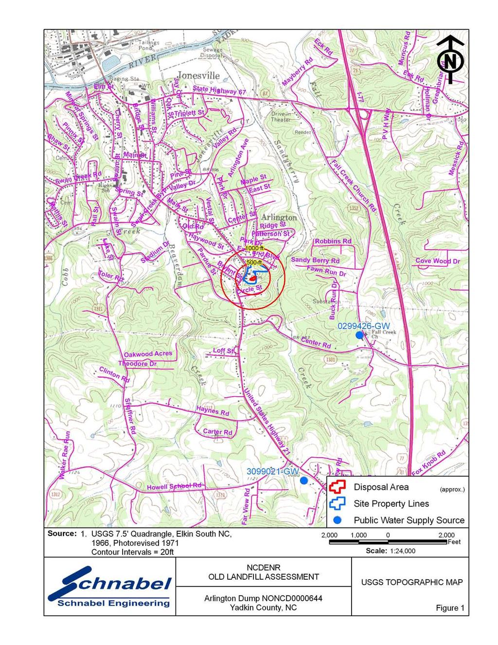
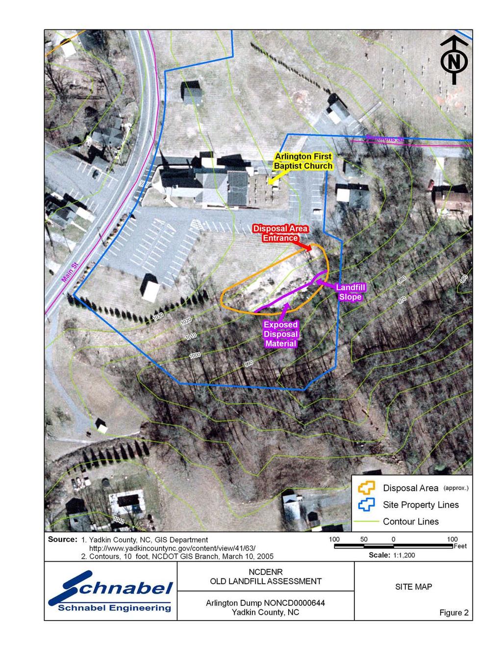
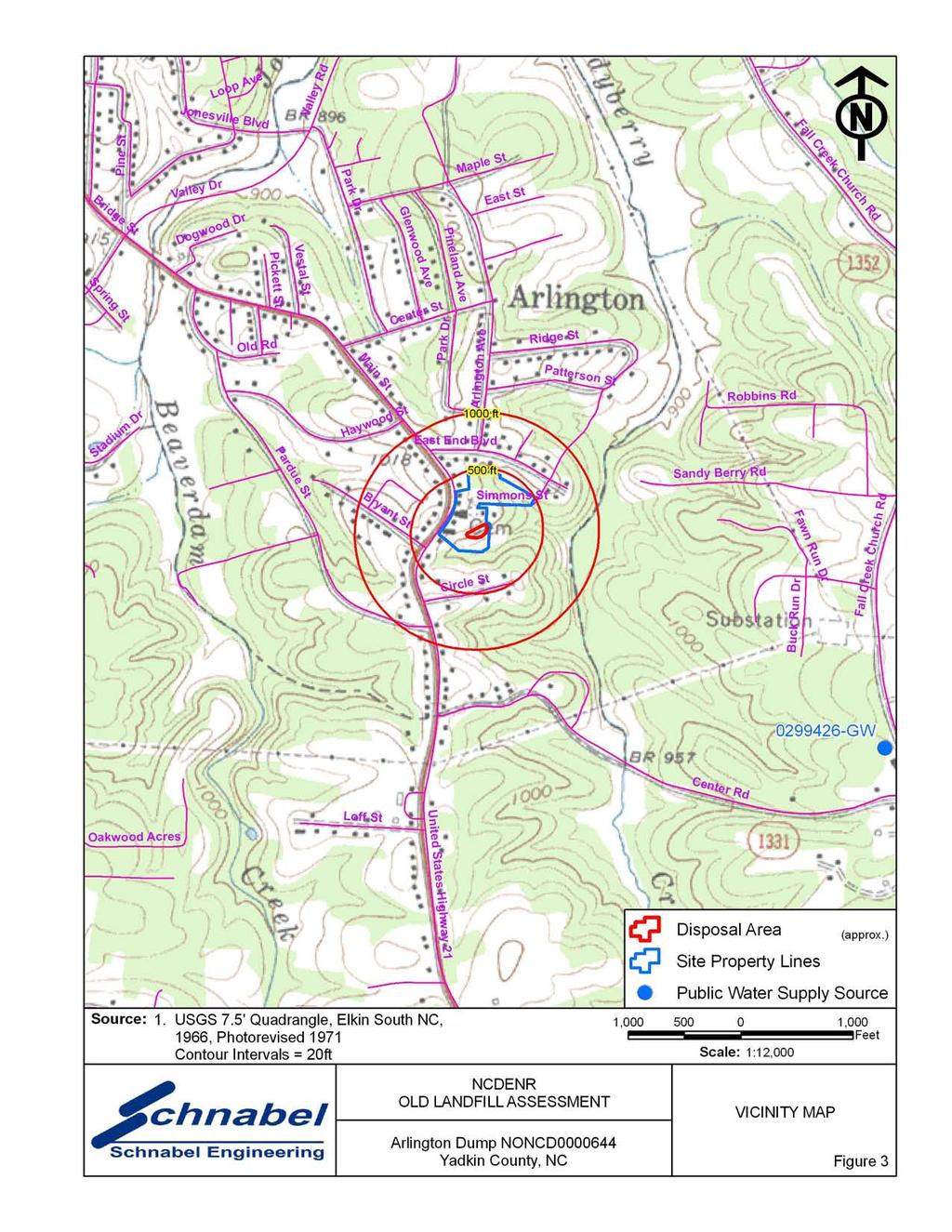
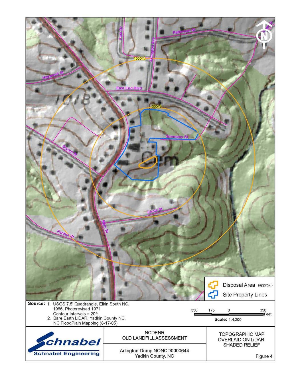
2 TABLE OF CONTENTS Site Location Research Summary Areas of Note Site Summary 1.0 Site Conditions 1.1 On-site Structures 1.2 Current Site Usage 1.3 On-site Water Supply Wells and Intakes 1.4 Surface Water Features 1.5 Disposal Area 1.6 Disposal Area Conditions 1.7 Evidence of Human Activity 1.8 Potential Landfill Gas Migration Pathways 1.9 Physical Barriers 1.10 Other Pertinent Information 2.0 Vicinity Conditions 2.1 Structures Located on Adjacent Properties 2.2 Water Supply Wells and Intakes 2.3 Current Land Usage 2.4 Surface Water Features 3.0 Aerial Photography Review Table 1 Tabulated GPS Coordinates TABLES Figure 1 Figure 2 Figure 3 Figure 4 Figure 5 Appendix A Appendix B Appendix C Appendix D Appendix E FIGURES USGS Topographic Map Site Map Vicinity Map Topographic Map Overlaid On LiDAR Shaded Relief LiDAR Shaded Relief APPENDICES Field Reconnaissance Sheet Tax Records Records of Communication\Site Visit Permission Letter Site Photographs Aerial Photographs FILE: G:\2006_PROJECTS\ _(NCDENR_OLD_UNLINED_LANDFILL)\TASK_15_YADKIN_CO\0644-ARLINGTON DUMP\REPORT\FINAL\NONCD _ARLINGTONDUMP_FINALSITESUMMARYREPORT_ DOC
3 SITE LOCATION RESEARCH SUMMARY ID NUMBER: NONCD SITE NAME(S): Arlington Dump LOCATION: 345 South Main Street, Jonesville, NC COUNTY: Yadkin LANDFILL SIZE: PROPERTY SIZE: DATE OPENED: DATE CLOSED: 0.3 acres (Disposal Area enclosed by GPS points obtained during site visit) 7.0 acres (from Yadkin County GIS) 1960 (data obtained from Bryan Wyatt, Arlington First Baptist Church, Grounds Manager) 1972 (data obtained from Bryan Wyatt, Arlington First Baptist Church, Grounds Manager) CURRENT OWNER: Arlington First Baptist Church CURRENT OWNER CONTACT: Pastor Jerry Fugate CURRENT OWNER ADDRESS: 345 South Main Street, Jonesville, NC CURRENT OWNER TELEPHONE NUMBER: TAX PARCEL No./PIN No.: Parcel No DEED REFERENCE: Deed Book 530, Deed Page 520 COORDINATES: (at site entrance of Parcel from on-site reading from handheld GPS) State Plane Coordinates (NAD83, meters): Northing: Easting: Latitude: N36 o Longitude: W80 o AREAS OF NOTE 1) The Arlington First Baptist Church and cemetery are located on the Site. 2) The Arlington First Baptist Church allows the Town of Jonesville to dispose of broken concrete on the Disposal Area. 3) Residences and the Arlington Fire & Rescue are located within 1,000 feet of the Disposal Area. Arlington Dump NONCD
4 SITE SUMMARY 1.0 SITE CONDITIONS This section discusses the observed conditions on the Site, as defined as the property (Tax Parcel ) on which the Disposal Area is located. The Disposal Area is defined as the area observed or reported to have been used for waste placement or burial. The boundary (perimeter) of this area is the observed limit of waste material based on field observations. Photographs illustrating site conditions are included in Appendix D. The Site is located in Yadkin County, near Jonesville, NC. Driving directions to the Site from the intersection of Interstate 77 North and US Highway 21 is as follows: 1) Take US Highway 21 (Main Street) north toward Jonesville and drive approximately 2.5 miles. 2) Arlington First Baptist Church is located on the right at 345 South Main Street. 1.1 On-site Structures The Arlington First Baptist Church and three garages are located on the Site. The church is located about 175 feet northwest of the Disposal Area. The church is in an apparent up-gradient direction from the Disposal Area. 1.2 Current Site Usage According to Mr. Bryan Wyatt, Church Grounds Manager, the Site is used by Arlington First Baptist Church. The church also allows the Town of Jonesville to dispose of concrete and asphalt on the Disposal Area. Arlington Dump NONCD
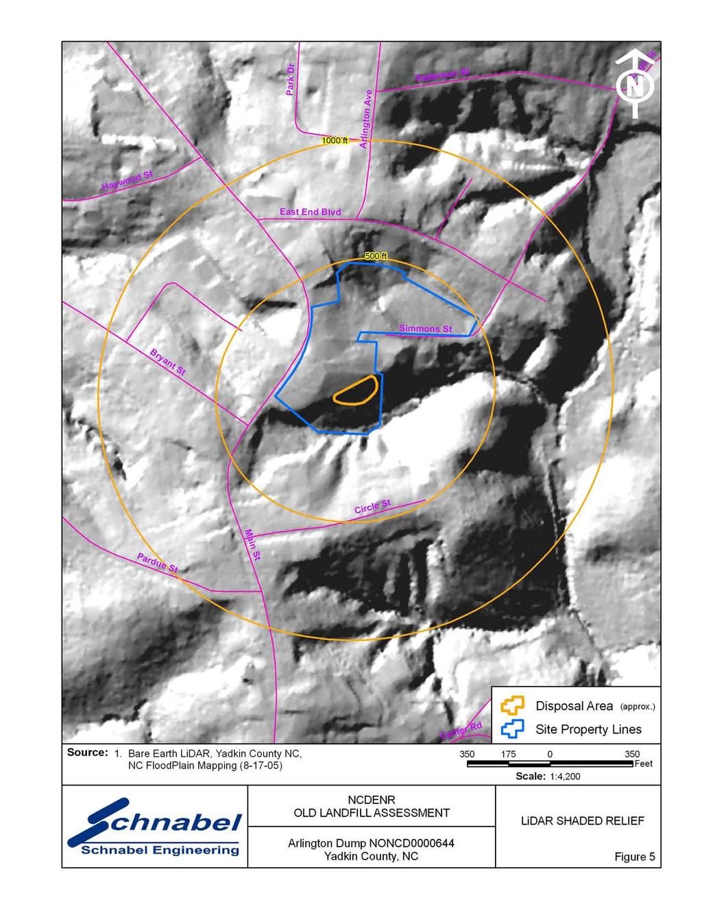
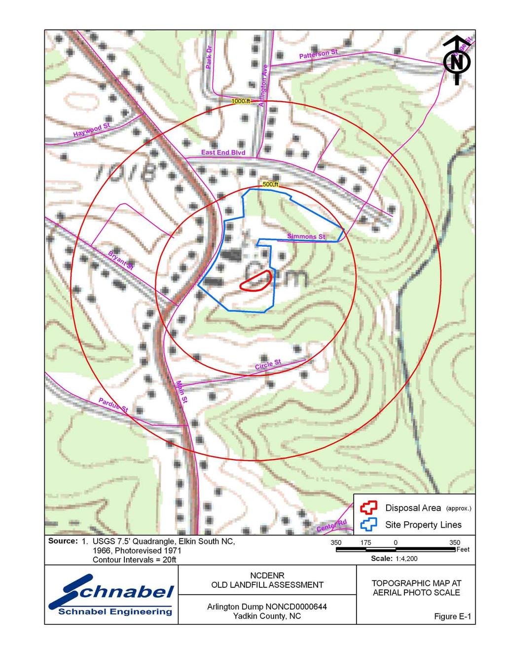
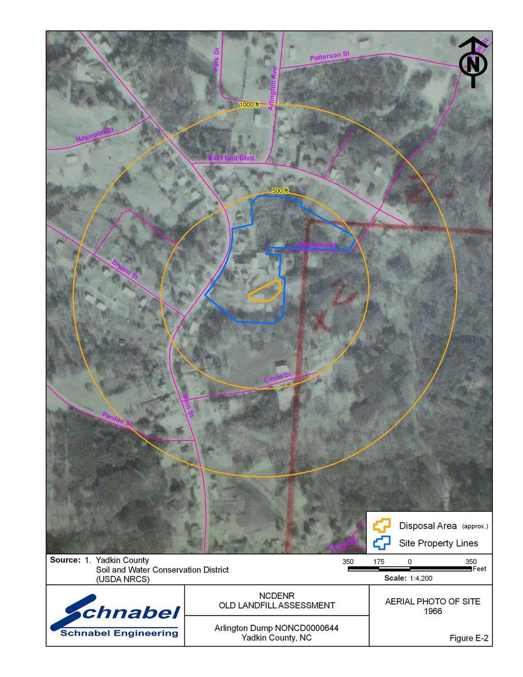
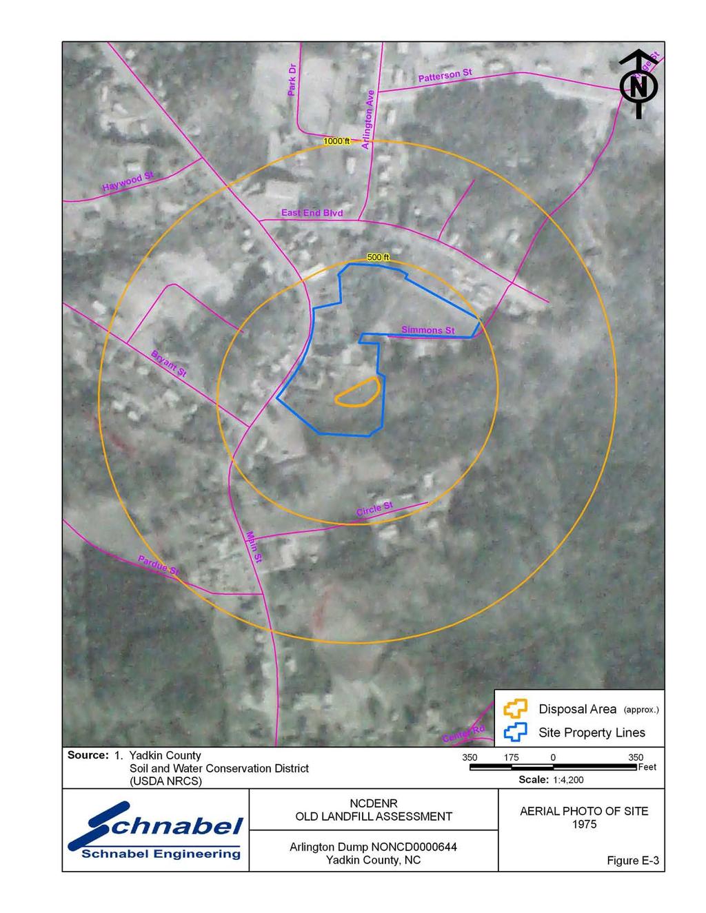
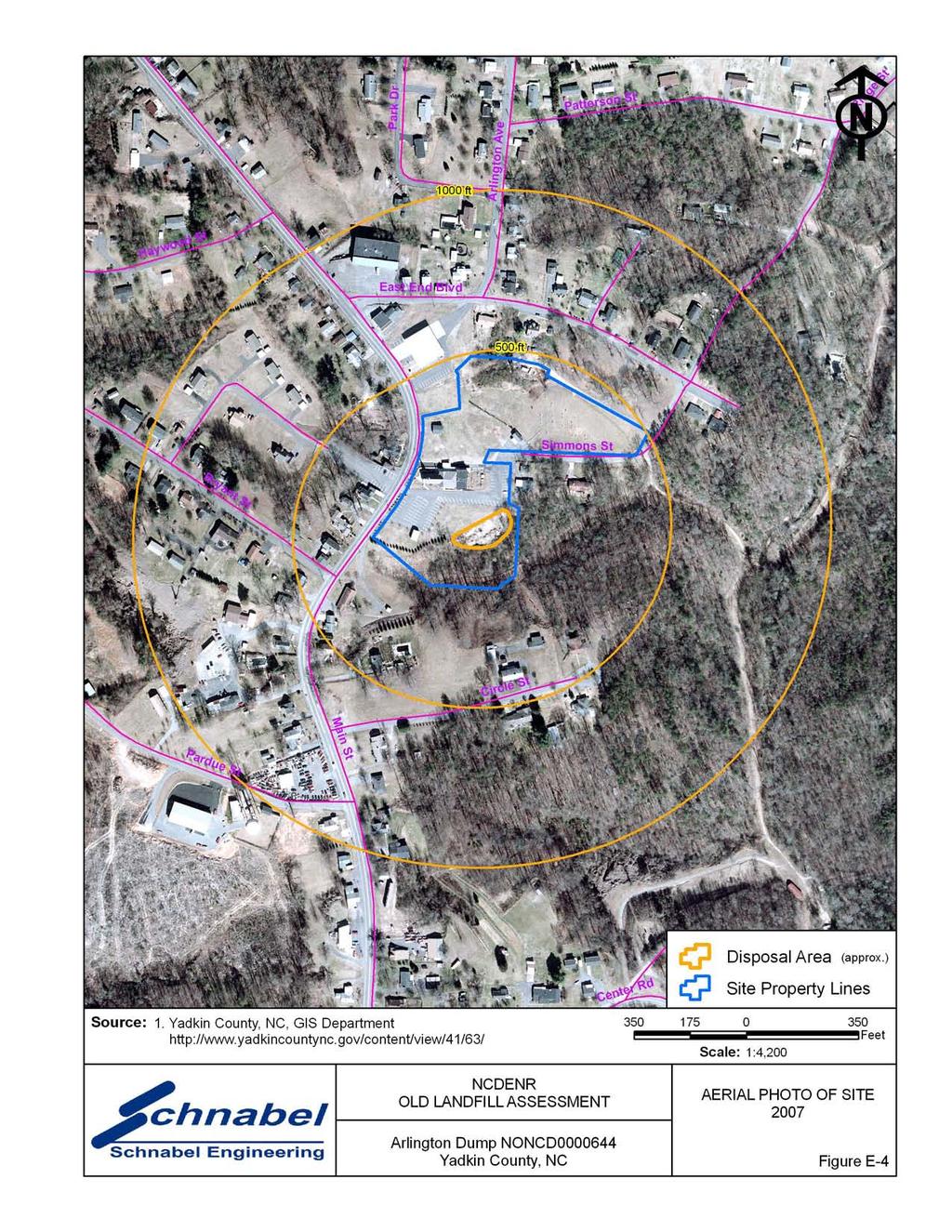
5 1.3 On-Site Water Supply Wells and Intakes No on-site water supply wells were observed on the Site during the site visit. A water meter was observed on the Site during the site visit. No fire hydrants were observed on the Site during the site visit. 1.4 Surface Water Features During the site visit, surface water features were not observed on the Site. 1.5 Disposal Area Access to the Disposal Area is from the Arlington First Baptist Church parking lot. The Disposal Area occupies 0.3 acres based on the Disposal Area perimeter shown on Figures 1 through 3. The Disposal Area generally slopes to the south. A comparison of the topography from the 1966 USGS 7.5 minute topographic quadrangle map (20 foot contours) with the 2005 topographic map from NCDOT (20 foot contours) suggests that up to about 10 feet of material has been placed on the southwest side of the Disposal Area. These estimated depths are approximate and differences in scale and methods of mapping are not sufficient to evaluate some changes in topography. GPS coordinates were taken of the Disposal Area perimeter. The approximate Disposal Area perimeter is illustrated on the figures and on aerial photographs in Appendix E. A table of GPS coordinates for the Site entrance and the Site perimeter is presented in Table 1. The Disposal Area perimeter location is approximate and is based on visual observations made at the time of the site visit. Figures 4 and 5 show LiDAR shaded relief superimposed on the Disposal Area. Arlington Dump NONCD
6 1.6 Disposal Area Conditions The Disposal Area was covered with grass, vines, briars, and small trees. A landfill slope was observed on the southeastern side of the Disposal Area. Visible debris, including concrete, asphalt, tires, furniture, and white goods, were observed on the landfill slope. The observed Disposal Area was on a single tax parcel, Parcel Number The boundaries of the Disposal Area were visible during the site visit. No notable erosion, depressions or hummocky topography, offensive odors, stained or discolored soils, or slope failures were observed during the site visit. 1.7 Evidence of Human Activity According to Mr. Bryan Wyatt, Church Grounds Manager, waste disposal of concrete and asphalt still occurs on the Disposal Area (Photos 3 and 5). 1.8 Potential Landfill Gas Migration Pathways There were no visible or evident potential gas migration pathways such as stormwater drain systems, underground utilities, septic systems, or drain fields observed on the Disposal Area or on the Site. 1.9 Physical Barriers Access to the Site is from the Arlington First Baptist Church parking lot. The Disposal Area is difficult to enter from the south due to dense vegetation. Arlington Dump NONCD
7 1.10 Other Pertinent Information Some history of the Site was obtained during conversations with persons familiar with the Site. The information obtained indicates that: Mr. Bryan Wyatt, Church Grounds Manager, stated that the Site is used by the Arlington First Baptist Church which was built in 1936 with building additions in Mr. Wyatt stated that the Church no longer uses the Disposal Area, but does allow the Town of Jonesville to dispose of broken concrete and asphalt. Mr. Wyatt stated that the Church and Town of Jonesville used the Disposal Area to dump concrete, brush, and other building materials. Mr. Wyatt stated that people illegally dumped on the Disposal Area, and that the Church put up a no dumping sign. Ms. Tammy Shore, Town of Jonesville Utilities Clerk, stated that the Town of Arlington was annexed into the Town of Jonesville a few years ago. Ms. Shore stated that she remembered a disposal area at the Arlington First Baptist Church located approximately one mile south of what used to be the center of the Town of Arlington. Ms. Shore stated that the Town of Jonesville places broken concrete and asphalt at Arlington First Baptist Church. Mr. Roger Martin, Town of Jonesville Public Works Director, stated that he had no knowledge of a Disposal Area near Arlington First Baptist Church. Mr. Martin stated that the Town of Arlington may have used the Site as a Disposal Area, but that the Town of Arlington and the Town of Jonesville have now merged. Notes from conversations with people familiar with the site are included in Appendix C. The information obtained from these conversations has not been verified or confirmed. Arlington Dump NONCD
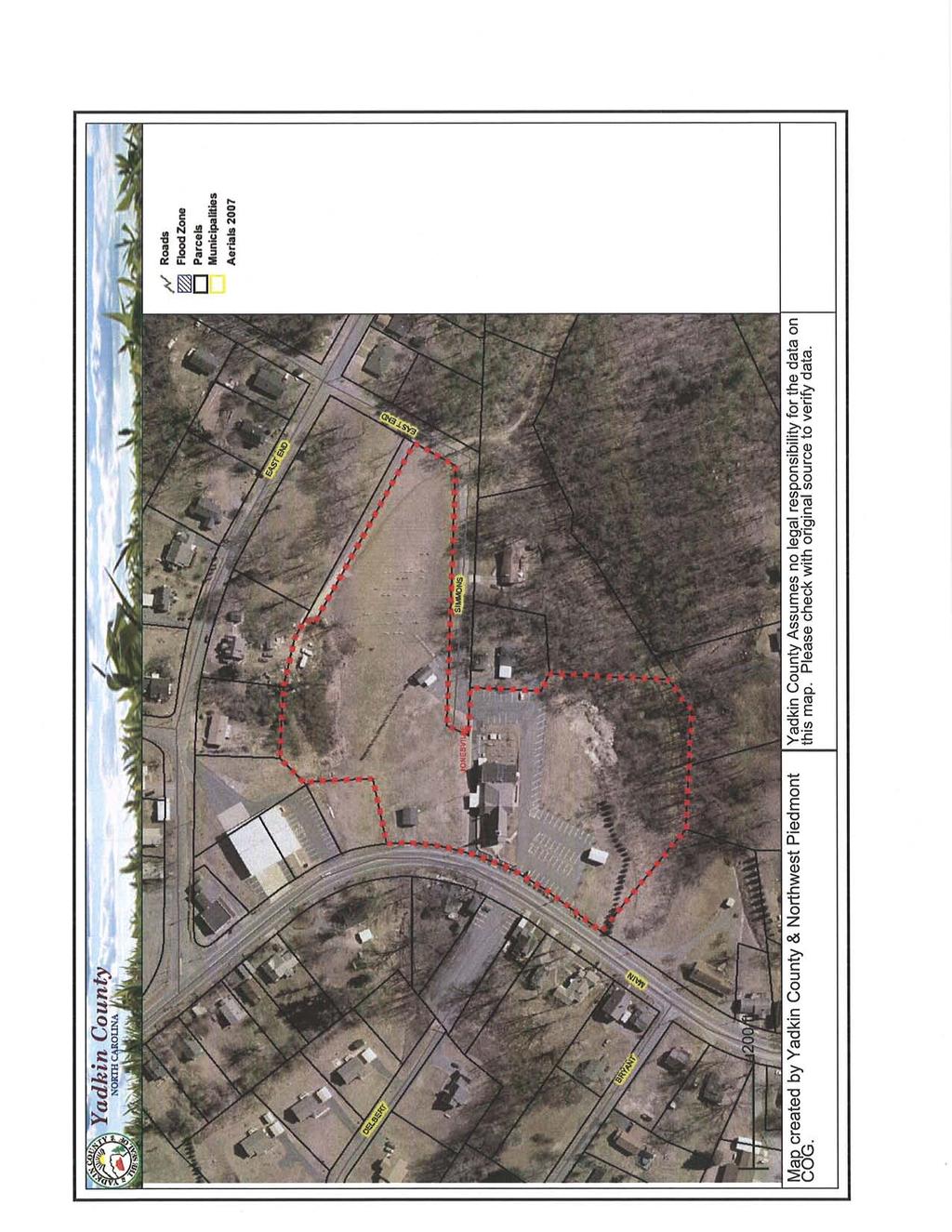
8 2.0 VICINITY CONDITIONS This section describes the observed general conditions in the vicinity of the Site, as defined as an area within 1,000 feet of the perimeter of the Disposal Area. Photographs illustrating vicinity conditions are included in Appendix D. 2.1 Structures Located on Adjacent Properties Structures described in this section are located on adjacent properties that have a shared property boundary with the Site. Several residences on multiple tax parcels are located to the north, west, and south of the Site. Two residences on separate tax parcels border the perimeter of the Site to the east. The Arlington Fire & Rescue (Tax Parcels , , , ) is adjacent to the Site to the north. These structures are shown on Figure 2 and on aerial photographs in Figures E1 through E4 in Appendix E. 2.2 Water Supply Wells and Intakes Water supply wells or well houses were not observed at residences along South Main Street and East Bend Boulevard within a 1,000-foot radius of the Disposal Area. Water meters were observed in the yards of several of the residences and fire hydrants were observed within 1,000 feet of the Site. The nearest public water supply registered on the NCDENR Public Water Supply Section s database (as of January 2008) is a public water supply well located at Fall Creek Baptist Church 3380 Fall Creek Church Road, Jonesville, NC This location is ¾ of a mile in an apparent up-gradient direction from the Site. The location and permit number for this well are shown on Figure 1. Arlington Dump NONCD
9 2.3 Current Land Usage Property in the vicinity of the Site is primarily residential, except for the area to the east which is wooded. Land usage at the time of the site visit within 1,000 feet of the Disposal Area perimeter was: North: Arlington First Baptist Church, cemetery, Arlington Fire and Rescue and residences, apparent up-gradient direction from site. South: Wooded and residences, apparent down-gradient direction from site. East: Two residences and wooded, apparent cross- and down-gradient direction from site. West: Arlington First Baptist Church parking lot and residences, apparent up-gradient direction from site. 2.4 Surface Water Features During the site visit, no surface water features were observed on the Site. Sandyberry Creek is located approximately 1,500 feet to the east and flows northward to the Yadkin River. Arlington Dump NONCD
10 3.0 AERIAL PHOTOGRAPHY REVIEW Aerial photographs were reviewed for the years 1966, 1975 and The reported years of operation of the Site were from 1960 to Observations of each of the photographs are included in the following table. Copies of the aerial photographs are included in Appendix E. Some aerial photographs are reproductions of original aerial photographs and have some distortion; therefore, overlaid Disposal Area Boundaries and other features may vary from their actual locations. Hand drawn lines and notations on the photographs denote soils mapping information drawn on the original photographs by the USDA NRCS. Flight Year Observations Source 1966 Disposal Area partially cleared. The Arlington First Baptist 1 Church is visible on the central part of the Site. The Site appears to be wooded and undeveloped in the northern part and along the southern and eastern perimeters. Residences are present to the north, south, and west of the Site. Two residences are present to the east of the Site perimeter Disposal Area is covered by vegetation and undeveloped Piles of debris in Disposal Area are visually evident in the southwestern part of the Site. The aerial photograph shows conditions representative of those observed during the visit. 2 Sources of aerial photos: 1) USDA NRCS office in Yadkin County, NC 2) Yadkin County GIS, This report was prepared specifically for the use of NCDENR Inactive Sites Branch under the Scope of Work defined in our contract dated October 26, Use of this document for other purposes or by other parties is at the sole risk of the user. Arlington Dump NONCD
11 TABLE
12 Point Site Entrance 001 TABLE 1 Tabulated GPS Coordinates State Plane Coordinates (meters) Latitude (deg, min, sec) Longitude (deg, min, sec) Northing Easting N W P P P P P P P P P P Notes: 1) All points P-1 through P-10 are on observed Disposal Area perimeter. 2) Data obtained during site visit using WAAS enabled Thales Mobile Mapper. 3) All points in NAD83 datum. Arlington Dump NONCD
13 FIGURES
14
15
16
17
18
19 FIELD RECONNAISSANCE SHEET
20
21
22
23
24
25
26 TAX RECORDS
27
28
29 RECORDS OF COMMUNICATION/SITE VISIT PERMISSION LETTER
30
31
32 RECORD OF CONVERSATION INTERVIEW SCHNABEL STAFF: Ben Bradley DATE/TIME: July 1, 2009 INTERVIEW WITH: Tammy Shore PHONE NO.: TITLE: Utilities Clerk FAX NO.: ORGANIZATION: Town of Jonesville ADDRESS: 116 East Market Street, Elkin, NC PROJECT: NC DENR Old Unlined Landfill Assessments SITE NAME AND NCDENR ID NO.: Arlington Dump, NONCD SUBJECT: Disposal Site Knowledge NOTES: On July 1, 2009 Ben Bradley interviewed Tammy Shore, Town of Jonesville Utilities Clerk, about her knowledge of Arlington Dump. Ms. Shore stated that the Town of Arlington was annexed into the Town of Jonesville a few years ago. Ms. Shore stated that she remembered a dumping area at the Arlington First Baptist Church located approximately one mile south of what used to be the center of the Town of Arlington. Ms. Shore stated that the Town of Jonesville places broken concrete and asphalt at Arlington First Baptist Church. G:\2006_projects\ _(NCDENR_Old_Unlined_Landfill)\Task_15_Yadkin_Co\0644-Arlington Dump\Report\Final\RecOfConv- TammyShore doc
33 RECORD OF CONVERSATION SITE ACCESS PERMISSION-INTERVIEW SCHNABEL STAFF: Ben Bradley DATE/TIME: July 8, 2009 INTERVIEW WITH: Bryan Wyatt PHONE NO.: TITLE: Church Grounds Manager FAX NO.: ORGANIZATION: Arlington First Baptist Church ADDRESS: 345 South Main Street, Jonesville, NC PROJECT: NC DENR Old Unlined Landfill Assessments SITE NAME AND NCDENR ID NO.: Arlington Dump, NONCD SUBJECT: Disposal Site Knowledge and Site Access Interview NOTES: On July 8, 2009 Ben Bradley interviewed Bryan Wyatt, Church Grounds Manager, about his knowledge of Arlington Dump. Mr. Wyatt stated that Arlington First Baptist Church was built in 1936, and additions were added in Mr. Wyatt stated that the Church and Town of Jonesville used the Disposal Area to dump concrete, brush, and other building materials. Mr. Wyatt stated that people illegally dumped on the Disposal Area, and that the Church put up a no dumping sign. Mr. Wyatt stated that the Church no longer disposes of material on the Disposal Area, but still allows the Town of Jonesville to dump broken concrete. G:\2006_projects\ _(NCDENR_Old_Unlined_Landfill)\Task_15_Yadkin_Co\0644-Arlington Dump\Report\Final\RecOfConv- BryanWyatt doc
34 RECORD OF CONVERSATION INTERVIEW SCHNABEL STAFF: Ben Bradley DATE/TIME: July 31, 2009 INTERVIEW WITH: Roger Martin PHONE NO.: TITLE: Public Works Director FAX NO.: ORGANIZATION: Town of Jonesville ADDRESS: 116 East Market Street, Elkin, NC PROJECT: NC DENR Old Unlined Landfill Assessments SITE NAME AND NCDENR ID NO.: Arlington Dump, NONCD SUBJECT: Disposal Site Knowledge NOTES: On July 31, 2009 Ben Bradley interviewed Roger Martin, Town of Jonesville Public Works Director, about his knowledge of Arlington Dump. Mr. Martin stated that he did not have any knowledge of the Disposal Area near Arlington First Baptist Church. Mr. Martin stated that the Town of Arlington may have used the Site as a Disposal Area, but that the Town of Arlington and the Town of Jonesville have now merged. G:\2006_projects\ _(NCDENR_Old_Unlined_Landfill)\Task_15_Yadkin_Co\0644-Arlington Dump\Report\Final\RecOfConv- RogerMartin doc
35 SITE PHOTOGRAPHS


36 PHOTOGRAPH No.: 1 Photo Taken: LOCATION: Arlington Dump entrance. Disposal Area entrance located at Arlington Baptist Church parking lot at 345 South Main Street. COMMENTS: Photo taken facing toward the southwest. PHOTOGRAPH No.: 2 Photo Taken: LOCATION: Northwest boundary of Disposal Area. COMMENTS: Photo taken facing toward the northeast. Arlington Dump, NONCD


37 PHOTOGRAPH No.: 3 Photo Taken: LOCATION: Northwest boundary of Disposal Area. COMMENTS: Photo taken facing toward the south. Concrete debris and shrubs. PHOTOGRAPH No.: 4 Photo Taken: LOCATION: Southeast part of Disposal Area. COMMENTS: Dense vegetation and deciduous trees two to three feet in diameter. Concrete debris visible on landfill slope. Arlington Dump, NONCD


38 PHOTOGRAPH No.: 5 Photo Taken: LOCATION: Southeast part of Disposal Area. COMMENTS: Asphalt debris. PHOTOGRAPH No.: 6 Photo Taken: LOCATION: Southwestern boundary of Disposal Area. COMMENTS: Furniture and concrete debris located at bottom of landfill slope. Arlington Dump, NONCD


39 PHOTOGRAPH No.: 7 Photo Taken: LOCATION: Southwestern part of Disposal Area. COMMENTS: Metal debris and water heater in dense vegetation. PHOTOGRAPH No.: 8 Photo Taken: LOCATION: Southwestern part of Disposal Area. COMMENTS: Discarded tires. Arlington Dump, NONCD
40 AERIAL PHOTOGRAPHS
41
42
43
44
SITE SUMMARY REPORT Rockingham Dump NONCD Richmond County
 SITE SUMMARY REPORT Rockingham Dump NONCD 0000517 Richmond County Senate Bill 1492 State of North Carolina State Contract N06009S Schnabel Project No. 06210002.24 July 26, 2010 Prepared for: North Carolina
Triangle Land Conservancy Conservation Area Monitoring Report Carolina North
 Triangle Land Conservancy Conservation Area Monitoring Report Carolina North Property Name: Bolin Creek West Conservation Area Date of visit: 2.18.13, 2.18.13, 3.13.13, and 6.10.13 County: Orange Property
Triangle Land Conservancy Conservation Area Monitoring Report Carolina North
 Triangle Land Conservancy Conservation Area Monitoring Report Carolina North Property Name: Bolin Creek West Conservation Area Date of visit: April 11, 2018 County: Orange Property Type: Restrictive Covenants
Preliminary Sediment & Stormwater Management Plan Review Checklist DATE RECEIVED: PROJECT NUMBER: PROJECT NAME:
 Preliminary Sediment & Stormwater Management Plan Review Checklist DATE RECEIVED: PROJECT NUMBER: PROJECT NAME: General Information: 1. Completed application signed by the owner, review fee, one set of
Triangle Land Conservancy Conservation Area Monitoring Report Carolina North
 Triangle Land Conservancy Conservation Area Monitoring Report Carolina North Property Name: Bolin Creek West Conservation Area Date of first visit: 3.12.14 County: Orange Date of second visit: 6.5.14 Property
MEMORANDUM OF BOG TURTLE HABITAT INVESTIGATION
 MEMORANDUM OF BOG TURTLE HABITAT INVESTIGATION 410-728-2900 Fax: 410-728-3160 www.rkk.com To: From: CC: U.S. Fish and Wildlife Service, Pennsylvania Fish and Boat Commission Jennifer A Ottenberg Miller,
June 22, 2018 Project No /2100
 June 22, 2018 Project No. /2100 Riotrin Properties (Gloucester 3) Inc. c/o Riocan Management Inc. Riocan Yonge Eglinton Centre 2300 Yonge Street, Suite 500 Toronto, Ontario M4P 1E3 PHASE I ENVIRONMENTAL
Sanford/Lee County Technical Review Committee (TRC) DEADLINES & MEETING DATES
 DEADLINES & MEETING DATES") Sanford/Lee County Technical Review Committee (TRC) DEADLINES & MEETING DATES The following 2019 information is based on the information available to staff at the time of creation. Dates & time may change
Sanford/Lee County Technical Review Committee (TRC) DEADLINES & MEETING DATES The following 2019 information is based on the information available to staff at the time of creation. Dates & time may change
PCE PRELIMINARY DRAINAGE ANALYSIS REPORT FOR WESTWOOD MIXED USE NEIGHBORHOOD PROJECT 772 NORTH FOREST ROAD TOWN OF AMHERST, ERIE COUNTY, NEW YORK
 PCE PRELIMINARY DRAINAGE ANALYSIS REPORT FOR WESTWOOD MIXED USE NEIGHBORHOOD PROJECT 772 NORTH FOREST ROAD TOWN OF AMHERST, ERIE COUNTY, NEW YORK MAY 19, 2014 Prepared By: Timothy M. Lavocat, P.E., CFM
Michael D, Harvey, Current Planning Supervisor. This project was originally approved in 2012 by the BOCC and is summarized as follows:
 PLANNING & INSPECTIONS DEPARTMENT Craig N. Benedict, AICP, Director Current Planning (919) 245-2575 (919) 644-3002 (FAX) www.orangecountync.gov 131 W. Margaret Lane Suite 201 P. O. Box 8181 Hillsborough,
I. INTRODUCTION. identify long-term capital improvements and rehabilitation measures for the existing drainage system;
 I. INTRODUCTION The Town of Windsor, Colorado is presently experiencing rapid growth and development within the boundaries of several of its major drainage basins. As growth continues within these basins,
North Carolina Department of Transportation Project Development and Environmental Analysis Branch
 North Carolina Department of Transportation Project Development and Environmental Analysis Branch Citizens Informational Workshop I-85, from I-485 to NC 73 Mecklenburg and Cabarrus Counties October 30,
III. PROJECT DESCRIPTION
 III. PROJECT DESCRIPTION A. PROJECT LOCATION Regional Setting The project site is located in the southeast quadrant of the City of Chico in Butte County, California and is comprised of four parcels totaling
STAFF REPORT FOR STANDARD COASTAL DEVELOPMENT PERMIT #CDP FEBRUARY 26, 2015 CPA - 1 PO BOX 238 APTOS, CA 94001
 STAFF REPORT FOR STANDARD COASTAL DEVELOPMENT PERMIT #CDP 2014-0030 FEBRUARY 26, 2015 CPA - 1 OWNER/APPLICANT: AGENT: REQUEST: HANS HEIM PO BOX 238 APTOS, CA 94001 JAMES HAY PO BOX 762 MENDOCINO, CA 95460
ARLINGTON COUNTY, VIRGINIA
 ARLINGTON COUNTY, VIRGINIA County Board Agenda Item Meeting of January 27, 2007 DATE: January 12, 2007 SUBJECT: U-3101-04-2 Use Permit Review for drive-through facilities; premises known as 5222 Lee Highway
URBAN DESIGN BRIEF 305, 309, & 315 SOUTHDALE ROAD WEST LONDON ONTARIO
 URBAN DESIGN BRIEF 305, 309, & 315 SOUTHDALE ROAD WEST LONDON ONTARIO CARVEST PROPERTIES LTD. December 2013 Section 1 - Land Use Planning Context 1.1 Subject Lands The subject lands are located immediately
LONDONDERRY PLANNING BOARD MINOR SITE PLAN APPLICATION & CHECKLIST
 LONDONDERRY PLANNING BOARD MINOR SITE PLAN APPLICATION & CHECKLIST Planning Department Date Stamp Design Review Formal Application Change of Use (No Site Improvements)* All information provided and submitted
NOTICE OF PREPARATION
 NOTICE OF PREPARATION DATE: January 6, 2016 TO: LEAD AGENCY: Responsible Agencies, Organizations, and Interested Parties Contact: Tyler Barrington, Principal Planner Planning Department Community Development
Poisoned Park? How Exide s Lead Contamination Risks Frisco s Grand Park
 Frisco City Hall has big plans to transform Stewart Creek into a Grand Park with lots of water features for kids to play in. Poisoned Park? How Exide s Lead Contamination Risks Frisco s Grand Park But
In Search of the Wyatt Chapel Cemetery Boundaries. Rice University Visiting Graduate Students Bill Baker Jared Sallee July 2010
 In Search of the Wyatt Chapel Cemetery Boundaries Rice University Visiting Graduate Students Bill Baker Jared Sallee July 2010 Review of Aerial Photographs - 2006 Review of Aerial Photographs - 1956 Review
168 & 170 BRADFORD STREET
 168 & 170 BRADFORD STREET City of Barrie prepared by: C.C. Tatham & Associates Ltd. 41 King Street, Unit 4 Barrie, Ontario L4N 6B5 Tel: (705) 733-9037 Fax: (705) 733-1520 info@cctatham.com prepared for:
2018 Annual Landfill Inspection Report
 2018 Annual Landfill Inspection Report Landfill H.W. Pirkey Plant Southwestern Electric Power Company Hallsville, Texas December 17, 2018 Prepared for: Southwestern Electric Power Company H.W. Pirkey Plant
PLANNED UNIT DEVELOPMENT & SUBDIVISION STAFF REPORT Date: May 18, 2017
 & PUD-0000102-2017 PLANNED UNIT DEVELOPMENT & SUBDIVISION STAFF REPORT Date: May 18, 2017 NAME SUBDIVISION NAME Dauphin Creek Estates Subdivision Dauphin Creek Estates Subdivision LOCATION CITY COUNCIL
Application for Site Plan Review
 Application for Site Plan Review City of Pontiac Office of Land Use and Strategic Planning 47450 Woodward Ave, Pontiac, MI 48342 T: 248.758.2800 F: 248.758.2827 Property/Project Address: Sidwell Number:
Eelgrass Distribution in the Great Bay Estuary and Piscataqua River for 2013
 University of New Hampshire University of New Hampshire Scholars' Repository PREP Publications Institute for the Study of Earth, Oceans, and Space (EOS) 5-17-2014 Eelgrass Distribution in the Great Bay
USA Addition of South & East Side Residential Parcels. USA Deletion of a Town of Christiana Parcel. Conversion from USA to Limited Service Area
 Village of Rockdale Village of Rockdale 148 Water Street Cambridge, WI 53523 Phone 608.423.1497 Fax 608.423.9694 Urban Service Area (USA) Amendment USA Addition of South & East Side Residential Parcels
Chapter 8: BEACH SOUTH OF ATLANTIC AVENUE NEIGHBORHOOD PLANNING AREA ANALYSIS
 Chapter 8: BEACH SOUTH OF ATLANTIC AVENUE NEIGHBORHOOD PLANNING AREA ANALYSIS The Beach South of Atlantic Avenue Neighborhood Planning Area includes the parcels adjacent to S Fletcher Avenue from Atlantic
Wisconsin NRCS Direct Volume Method Bank Recession Rate Categorizations
 2 Executive Summary The City of Ramsey contracted the Anoka Conservation District to complete an inventory of riverbank condition along the entire 5.8 miles of City that border the Mississippi River. The
LONDONDERRY PLANNING BOARD SITE PLAN APPLICATION & CHECKLIST
 LONDONDERRY PLANNING BOARD SITE PLAN APPLICATION & CHECKLIST Planning Department Date Stamp Design Review Formal Application All information provided and submitted with this Application Checklist shall
Procedures IV. V. Rural Road Design Option
 i IV. Procedures A. All applicants required to prepare a Conservation Design Subdivision shall provide the Planning Board with a conceptual conventional subdivision design as well as a proposed layout
² Vicinity Map. Feet. DCB Construction Company Inc. 700 Golden Ridge Road JEFFERSON COUNTY PARKWAY 6 HIGHWAY 6 HIGHWAY WARNER DRIVE
 HERITAGE ROAD JEFFERSON COUNTY PARKWAY 6 HIGHWAY 6 HIGHWAY WARNER DRIVE GOLDEN CIRCLE H STREET G STREET Vicinity Map Feet ² 25 5 Case No.: Applicant: Location: Request: PC12-29 DCB Construction Company
Town of Portola Valley General Plan. Nathhorst Triangle Area Plan
 Town of Portola Valley General Plan Amended December 10, 1997 Table of Contents Introduction... 1 Planning Area... 1 Objectives... 2 Principles... 2 Standards... 4 Description... 4 Community Commercial...
PROJECT SCOPE OF WORK CITY OF TOWN AND COUNTRY STORMWATER PROGRAM
 PROJECT SCOPE OF WORK CITY OF TOWN AND COUNTRY STORMWATER PROGRAM Project Name: 362 Featherstone Dr Project ID Number: 27-3 Problem: Anecdotal evidence suggests a natural spring exists in the backyard
St. Louis Ice Center in Creve Coeur Lake Memorial Park
 Carol S. Comer, Director Missouri Department of Natural Resources P.O. Box 176 Jefferson City, MO 65102 Re: St. Louis Ice Center in Creve Coeur Lake Memorial Park Dear Ms. Comer: We are writing on behalf
URBAN DESIGN BRIEF. 2136&2148 Trafalgar Road. Town of Oakville
 URBAN DESIGN BRIEF 2136&2148 Trafalgar Road Town of Oakville Prepared By: METROPOLITAN CONSULTING INC For 2500674 Ontario Inc November 2016 TABLE OF CONTENTS Page No. 1.0 Introduction/Description of Subject
ZONING ORDINANCE FOR THE ZONED UNINCORPORATED AREAS ARTICLE 1150 OF PUTNAM COUNTY, WEST VIRGINIA Page 95 ARTICLE 1150 SITE PLAN REVIEW
 OF PUTNAM COUNTY, WEST VIRGINIA Page 95 1150.01 PURPOSE 1150.02 APPLICABILITY 1150.03 APPLICATION PROCESS 1150.04 REVIEW PROCESS 1150.05 REVIEW CRITERIA 1150.06 SITE PLAN GUIDELINES 1150.01 PURPOSE ARTICLE
CONCEPT PLAN APPLICATION
 CONCEPT PLAN APPLICATION TOWN OF CHAPEL HILL Planning Department 405 Martin Luther King Jr. Blvd phone (919) 968-2728 fa (919) 969-2014 www.townofchapelhill.org Parcel Identifier Number (PIN): 9880267455
5.1.1 The streetscape along US Highway 64 (Brevard Road); and, The built environment within new residential developments; and,
; and, The built environment within new residential developments; and,") Article 5. Landscaping 5.1 Purpose The Town of Laurel Park s landscape standards are designed to create a beautiful, aesthetically pleasing built environment that will complement and enhance community
Article 5. Landscaping 5.1 Purpose The Town of Laurel Park s landscape standards are designed to create a beautiful, aesthetically pleasing built environment that will complement and enhance community
PROPOSED DRAINAGE PATTERNS
 1121 1118.50 Basin Floor 1120 1119 0 N 100 200 PROPOSED DRAINAGE PATTERNS Deroiser Drive Riverwood Drive County 260 0 100 200 Project Name: Riverwood Drive LITTLE FALLS TOWNHOMES Project Location: LITTLE
ENBRIDGE GAS DISTRIBUTION INC. Proposed Relocation for Ninth Line, Markham and Whitchurch-Stouffville. Environmental Screening Report
 Page 1 of 18 ENBRIDGE GAS DISTRIBUTION INC. Proposed Relocation for Ninth Line, Markham and Whitchurch-Stouffville Environmental Screening Report July 2011 Page 2 of 18 Table of Contents 1.0 INTRODUCTION
OVERMOUNTAIN VICTORY TRAIL BURKE CALDELL CORRIDOR FEASIBLITY STUDY REQUEST FOR QUALIFICATIONS CALDWELL COUNTY PATHWAYS
 OVERMOUNTAIN VICTORY TRAIL BURKE CALDELL CORRIDOR FEASIBLITY STUDY REQUEST FOR QUALIFICATIONS CALDWELL COUNTY PATHWAYS Caldwell County Pathways along with our co-partners City of Lenoir, Town of Gamewell,
M E M O R A N D U M January 6, 2017
 Item #4 M E M O R A N D U M January 6, 2017 To: 2035 Corridor Planning Committee From: Kenneth Baker, Sr. Director of Planning and Development Services Subject: Item #4 Overview Fidelis Purpose: Review
The Maryland-National Capital Park and Planning Commission Prince George's County Planning Department Development Review Division
 The Maryland-National Capital Park and Planning Commission Prince George's County Planning Department Development Review Division 301-952-3530 Note: Staff reports can be accessed at www.mncppc.org/pgco/planning/plan.htm.
SHORE PROTECTION ACT STAFF S FINDINGS & RECOMMENDATIONS
 SHORE PROTECTION ACT STAFF S FINDINGS & RECOMMENDATIONS TO: FROM: Shore Protection Committee: Commissioner Mark Williams, Chairman Mr. Richard Gardner Mr. Henry Morgan Mr. Zach Harris Mr. Bill Hodges Department
PROJECT SCOPE OF WORK CITY OF TOWN AND COUNTRY STORMWATER PROGRAM
 PROJECT SCOPE OF WORK CITY OF TOWN AND COUNTRY STORMWATER PROGRAM Project ID Number: 25-5 Problem: Stormwater collected from the neighborhood upstream is released at 9 Muirfield Lane and flows west toward
2.0 Hi s t o r y & Existing Co n d i t i o n s
 2.0 Hi s t o r y & Existing Co n d i t i o n s 2.1 Plan Area History The Lincoln East Specific Plan (Specific Plan) area is a significant part of the history of Sutter County. A 48,000 acre land grant
Gadsden County Planning Commission Agenda Request
 Date of Meeting: November 16, 2017 To: From: Through: Subject: Gadsden County Planning Commission Agenda Request Honorable Chairperson and Members of the Board Jill A. Jeglie, AICP, Senior Planner Clyde
Specifications for Investigation and Perpetuation of U.S. Public Land Survey Corners
 Specifications for Investigation and Perpetuation of U.S. Public Land Survey Corners John M. Thornton State Land Surveyor January 12, 2016 SPECIFICATIONS FOR INVESTIGATION AND PERPETUATION OF U. S. PUBLIC
Advance Engineering & Surveying PLLC
 Advance Engineering & Surveying, PLLC Consulting in: Civil & Environmental Engineering Land Surveying Land Development 11 Herbert Drive Phone: (518) 698-3772 Latham, N.Y. 12110 Email:ncostape@gmail.com
AN ARCHAEOLOGICAL SURVEY FOR THE RICHARDS, TEXAS FARM-TO-MARKET ROAD 149 FIBER OPTIC CABLE PROJECT IN MONTGOMERY COUNTY, TEXAS
 AN ARCHAEOLOGICAL SURVEY FOR THE RICHARDS, TEXAS FARM-TO-MARKET ROAD 149 FIBER OPTIC CABLE PROJECT IN MONTGOMERY COUNTY, TEXAS Antiquities Permit 6097 By William E. Moore Brazos Valley Research Associates
Project: Developer/Designer: Reviewer: I. Narrative: 1. Project Description: Describes the nature and purpose of the land disturbing activity.
 City of Charlottesville, Virginia Erosion and Sediment Control Plan Review Checklist 610 East Market Street, Charlottesville, VA 22902 Telephone 434-970-3182; Fax 434-970-3359 Project: Developer/Designer:
CITY OF VACAVILLE PLANNING COMMISSION Item No. 8.A STAFF REPORT July 18, 2016 STAFF CONTACT: Amy Feagans, Contract Planner (707)
") CITY OF VACAVILLE PLANNING COMMISSION Item No. 8.A STAFF REPORT July 18, 2016 STAFF CONTACT: Amy Feagans, Contract Planner (707) 449-5140 TITLE: THE FARM AT ALAMO CREEK ENVIRONMENTAL IMPACT REPORT (EIR)
CITY OF VACAVILLE PLANNING COMMISSION Item No. 8.A STAFF REPORT July 18, 2016 STAFF CONTACT: Amy Feagans, Contract Planner (707) 449-5140 TITLE: THE FARM AT ALAMO CREEK ENVIRONMENTAL IMPACT REPORT (EIR)
Cloud and Banner Mitigation Site Latitude: 36 8' 38.41" N Longitude:79 16' 16.14" W
 Cape Fear River Basin HUC 03030002 Not to Scale Latitude: 36 8' 38.41" N Longitude:79 16' 16.14" W ^_ Latitude: 35 58' 30.37" N Longitude:79 11' 10.77" W ^_ Document Path: C:\Users\Brad\Dropbox (RES)\@RES
STAFF REPORT INTRODUCTION
 STAFF REPORT SUBJECT: DATE: Application for Master Land Use Plan Modification Southern Village Master Land Use Plan (Project No. 12-101) May 22, 2013 (Community Design Commission) May 23, 2013 (Transportation
September 14, Ken Cunningham, Chief a I. Conservation Services Division ti9 r< New Mexico Department of Game and Fish. P0 Box
 September 14, 2011 j Conservation Services Division ti9 r< Ken Cunningham, Chief a I fl4j Richardson Building www.urscorp.com Fax: 575-526-1390 Phone: 575-526-1180 Las Cruces, NM 88005-2610 101 North Alameda,
Rezoning Petition Pre-Hearing Staff Analysis May 21, 2018
 Rezoning Petition 2018-028 Pre-Hearing Staff Analysis May 21, 2018 REQUEST Current Zoning: MX-1 LLWPA (mixed use district, Lower Lake Wylie Protected Area), R-3 LLWPA (single family residential, Lower
Pond Siting Report Update
 Pond Siting Report Update Prepared for: Florida Department of Transportation District 5 CR 46A Realignment from SR 46 to North of Arundel Way Lake County, Florida FPID No. 238275-8-32-02 October 2013 (Draft
Rezoning Petition Final Staff Analysis June 18, 2018
 Rezoning Petition 2018-028 Final Staff Analysis June 18, 2018 REQUEST Current Zoning: MX-1 LLWPA (mixed use district, Lower Lake Wylie Protected Area), R-3 LLWPA (single family residential, Lower Lake
Project phasing plan (if applicable) 12 copies of site plan
 12 copies of site plan") SITE PLAN REVIEW PERMIT APPLICATION City of Grand Haven, 11 N. Sixth Street, Grand Haven, MI 49417 Phone: (616) 847-3490 Fax: (616) 844-2051 Website: www.grandhaven.org 1. Project Information Address/location
SITE PLAN REVIEW PERMIT APPLICATION City of Grand Haven, 11 N. Sixth Street, Grand Haven, MI 49417 Phone: (616) 847-3490 Fax: (616) 844-2051 Website: www.grandhaven.org 1. Project Information Address/location
James Dick Construction Limited Erin Pit Extension
 VISUAL IMPACT REPORT James Dick Construction Limited Erin Pit Extension Part of Lots 11, 12 & 13, Concession 6 WHS Town of Caledon, Region of Peel Date: November 2016 Prepared for: Prepared by: James Lockhart,
Urban Design Brief Woodland Cemetery Funeral Home 493 Springbank Drive
 Urban Design Brief Woodland Cemetery Funeral Home The Incorporated Synod of the Diocese of Huron April 15, 2016 Urban Design Brief April 15, 2016 TABLE OF CONTENTS Page No. INTRODUCTION... 1 SECTION 1
Amendment C146 Melton Planning Scheme Expert Evidence Statement Traffic & Transport Beattys Road, Plumpton
 235 311 Beattys Road, Plumpton 16585REP001C-F 21 November 2016 onemilegrid.com.au 1/59 Keele Street, Collingwood, VIC 3066 (03) 9939 8250 onemilegrid ABN: 79 168 115 679 (03) 9939 8250 1/59 Keele Street
I. DESCRIPTION OF PROPOSED ACTION... 1 A. General Description... 1 B. Historical Resume and Project Status... 2 C. Cost Estimates...
 PROJECT COMMITMENTS SUMMARY... S-1 1. Type of Action... S-1 2. Description of Action... S-1 3. Summary of Purpose and Need... S-1 4. Alternatives Considered... S-2 5. NCDOT Alternatives Carried Forward...
DRIVEWAY REGULATIONS
 TOWN OF NEW LONDON PLANNING BOARD DRIVEWAY REGULATIONS INSTRUCTIONS TO APPLICANTS FOR THE CONSTRUCTION OR ALTERATION OF DRIVEWAYS IMPORTANT: READ CAREFULLY BEFORE FILLING OUT ATTACHED APPLICATION Revised
Request Modification of Conditions of a Conditional Use Permit approved October 14, Staff Recommendation Approval. Staff Planner Stephen White
 Applicant Property Owner Public Hearing September 13, 2017 City Council Election District Lynnhaven Agenda Item 3 Request Modification of Conditions of a Conditional Use Permit approved October 14, 2003.
CRESCENT RESOURCES INC.
 CRESCENT RESOURCES INC. Due Diligence Checklist Project Name: Client: Project No. Date: 1 Survey Review survey for compliance with Crescent Resources, Inc. s Instructions to Surveyors (see below): All
GIS Training of Undergraduates: Campus Stormwater Mapping. Joanne Logan, University of Tennessee. Gordie Bennett, University of Tennessee
 GIS Training of Undergraduates: Campus Stormwater Mapping Joanne Logan, University of Tennessee Gordie Bennett, University of Tennessee Seth Benge, University of Tennessee Tim Prather, University of Tennessee
City of Fontana Notice of Preparation and Notice of Public Scoping Meeting Fontana North Walmart Project
 Notice of Preparation and Notice of Public Scoping Meeting Fontana North Walmart Project Date: Monday, February 22, 2016 To: From: Subject: Public Agencies and Interested Parties Orlando Hernandez, Senior
IS THERE MONEY AVAILABLE FOR WORK IN HISTORIC CEMETERIES? The AHC is not aware of any funding available for cemetery preservation or maintenance.
 ALABAMA HISTORICAL COMMISSION The State Historic Preservation Office Voice: (334)242-3184 Fax: (334)262-1083 www.preserveala.org ALABAMA HISTORIC CEMETERY REGISTER WHAT IS THE ALABAMA HISTORIC CEMETERY
Ramsey Center area - potential BMP sites
 Ramsey Center area - potential BMP sites Lilly Branch Carlton St. 1 2 Joe Frank Harris Commons 3 4 8 5 East Campus Rd. 11 6 12 7 9 East Campus Deck 10 20 16 17 Ramsey Center 13 14 18 19 15 River Road Road
Asbury Chapel Subdivision Sketch Plan
 Asbury Chapel Subdivision Sketch Plan PART 1: PROJECT SUMMARY Applicant: NVR Inc. Project Size: +/- 76.13 acres Parcel Numbers: 02101112,02116101,02116112, 02116113 Current Zoning: Transitional Residential
Phase One Archaeological Investigation Results, James Madison Park Master Development Plan Project, City of Madison, Dane County, Wisconsin
 Phase One Archaeological Investigation Results, James Madison Park Master Development Plan Project, City of Madison, Dane County, Wisconsin Prepared for the City of Madison Parks Department 28 January
November 2, 2015 at 5:15pm City Council Chambers, 3rd Floor, City Hall, 1737 Main Street Columbia, South Carolina 29201
 Subject Property: PLANNING COMMISSION SITE/SUBDIVISION PLAN CASE SUMMARY 10.21 ACRES, WESTSIDE OF CLIF KINDER BOULEVARD COTTAGES AT BURNSIDE FARM BURNSIDE FARMS ASSOCIATES, LLC November 2, 2015 at 5:15pm
ARLINGTON COUNTY, VIRGINIA HISTORICAL AFFAIRS AND LANDMARK REVIEW BOARD APPLICATION FOR CERTIFICATE OF APPROPRIATENESS
 ARLINGTON COUNTY, VIRGINIA HISTORICAL AFFAIRS AND LANDMARK REVIEW BOARD APPLICATION FOR CERTIFICATE OF APPROPRIATENESS DATE Z- - -HD RPC# (TO BE COMPLETED BY STAFF) DESIGNATED PROPERTY: Name of Historic
COMMUNITY DEVELOPMENT SERVICES PLANNING AND BUILDING DEPARTMENT
 COMMUNITY DEVELOPMENT SERVICES PLANNING AND BUILDING DEPARTMENT http://www.edcgov.us/devservices/ PLACERVILLE OFFICE: 2850 Fairlane Court, Placerville, CA 95667 BUILDING (530) 621-5315 / (530) 622-1708
SITE PLAN REVIEW APPLICATION
 SITE PLAN REVIEW APPLICATION CITY OF THE DALLES Community Development Department 313 Court Street The Dalles, OR 97058 (541) 296-5481, ext. 1125 Fax (541) 298-5490 www.ci.the-dalles.or.us Date Filed File#
RZC Public View Corridors and Gateways
 RZC 21.42 Public View Corridors and Gateways 21.42.010 Purpose 21.42.020 Scope and Authority 21.42.030 Administration 21.42.040 Gateways Design 21.42.050 Unidentified Public Views 21.42.060 Identification
Madison County Data List December 16, 2008
 Madison County Data List December 16, 2008 This data list is current as of the date listed above. This does not imply that the datasets listed are current. Although a dataset may be listed it may not be
Colerain Township report to. Hamilton County Regional Planning Commission. December 2, 2010, 1:00PM. t a f f r e p o r t
 Colerain Township report to Hamilton County Regional Planning Commission December 2, 2010, 1:00PM Preliminary Plan: Case No.: ZA2001-04, Forevergreen Prepared By: Amy Bancroft, Land Use Planner t a f f
JOINT PUBLIC NOTICE. 26 June United States Army Corps of Engineers State of Louisiana
 JOINT PUBLIC NOTICE 26 June 2017 United States Army Corps of Engineers State of Louisiana New Orleans District Department of Environmental Quality Regulatory Branch Office of Environmental Services 7400
PLANNED UNIT DEVELOPMENT APPLICATION
 PLANNED UNIT DEVELOPMENT APPLICATION CITY OF THE DALLES Community Development Department 313 Court Street The Dalles, OR 97058 (541) 296-5481, ext. 1125 Fax (541) 298-5490 www.ci.the-dalles.or.us Date
Town of Windham. Planning Department 8 School Road Windham, ME voice fax
 Town of Windham Planning Department 8 School Road Windham, ME 04062 voice 207.864-5960 fax 207.892.1916 MEMO DATE: TO: Staff Review Committee FROM: Amanda Lessard, Planner Cc: Ellen Rathbone, St. Germain
November 21, Planning Commission Charter Township of Lyon Grand River Ave. New Hudson, MI 48165
 Planning Commission Charter Township of Lyon 58000 Grand River Ave. New Hudson, MI 48165 Subject: AP-18-68; 11 Mile and Milford Road Park, Site Plan Review #1 Based on site plan dated 11/12/18 Location:
UNIVERSITY OF MICHIGAN:
 Chapter Eight UNIVERSITY OF MICHIGAN: North Campus I. Introduction The University of Michigan currently owns approximately 800 acres of land in the northeast section of Ann Arbor. North Campus refers to
ARTICLE 3. LARGE-SCALE SOLAR PHOTOVOLTAIC INSTALLATIONS SECTION XXI
 ARTICLE 3. LARGE-SCALE SOLAR PHOTOVOLTAIC INSTALLATIONS SECTION XXI 1.1 PURPOSE The purpose of this by-law is to regulate the installation of solar photovoltaic installations that are to produce 250 kw
Final Initial Study. Chalice Unitarian Universalist Congregation Conditional Use Permit
 5 Final Initial Study Chalice Unitarian Universalist Congregation Conditional Use Permit Appendix B Chalice Unitarian Universalist Congregation Cultural Resources Memorandum TRC 9685 Research Drive Irvine,
Architectural Inventory Form
 COLORADO CULTURAL RESOURCE SURVEY Page 1 of 8 Official Eligibility Determination (OAHP use only) Rev. 9/98 OAHP1403 Date Initials Determined Eligible National Register Determined Not Eligible National
IMPORTANT NOTICE. Architectural Inventory Form COLORADO CULTURAL RESOURCE SURVEY I. IDENTIFICATION th Street 5WL.5601
 IMPORTANT NOTICE OAHP1403 Rev. 9/98 COLORADO CULTURAL RESOURCE SURVEY Architectural Inventory Form Page 1 This survey form represents an UNOFFICIAL COPY and is provided for informational purposes only.
HEALTH SCIENCES BUILDING REDEVELOPMENT PROJECT
 INTRODUCTION In recent years, the University of Cincinnati (University) has demonstrated a commitment to identifying and implementing sustainable goals and objectives throughout University s Uptown Campuses.
Chapter 4 - Preparation of Stormwater Site Plans
 Chapter 4 - Preparation of Stormwater Site Plans The Stormwater Site Plan is the comprehensive report containing all of the technical information and analysis necessary for the City to evaluate a proposed
CHAPTER 26 LANDSCAPING (Chapter added in its entirety 05-08)
") CHAPTER 26 LANDSCAPING (Chapter added in its entirety 05-08) 26.01 DESCRIPTION AND PURPOSE. Landscaping is an important element of the use, development and preservation of land, and a significant factor
CHAPTER 26 LANDSCAPING (Chapter added in its entirety 05-08) 26.01 DESCRIPTION AND PURPOSE. Landscaping is an important element of the use, development and preservation of land, and a significant factor
October 28, May 25, 2010
 October 28, 2009 May 25, 2010 Jim Farr Staff Director, Acquisition and Restoration Council Office of Environmental Services Division of State Lands Florida Department of Environmental Protection 3900 Commonwealth
Agenda Item. Applicant Logan Virginia Properties, LLC Property Owners Byler Azalea, LLC & Gateway Free Will Baptist Chuch
 Applicant Property Owners Byler Azalea, LLC & Gateway Free Will Baptist Chuch Public Hearing March 14, 2018 City Council Election District Kempsville Agenda Item 6 Request Conditional Rezoning (B-2 Community
HISTORIC SITE FORM - HISTORIC SITES INVENTORY PARK CITY MUNICIPAL CORPORATION (10-08) 1 IDENTIFICATION
 1 IDENTIFICATION") HISTORIC SITE FORM - HISTORIC SITES INVENTORY PARK CITY MUNICIPAL CORPORATION (10-08) 1 IDENTIFICATION Name of Property: Wilson-Shields House Address: 139 Park Avenue City, County: Park City, Summit County,
HISTORIC SITE FORM - HISTORIC SITES INVENTORY PARK CITY MUNICIPAL CORPORATION (10-08) 1 IDENTIFICATION Name of Property: Wilson-Shields House Address: 139 Park Avenue City, County: Park City, Summit County,
Stormwater Pollution Prevention Plan Oneonta Heights Oneonta, NY TABLE OF CONTENTS PAGE
 Oneonta Heights Oneonta, NY TABLE OF CONTENTS PAGE I. INTRODUCTION... 2 II. EXISTING CONDITIONS... 3 A. Topography/ Drainage... 3 B. Soils... 3 C. Wetlands... 3 D. Floodplain... 3 E. NYSDEC Environmental
MacDonnell Heights Town Center
 Draft Environmental Impact Statement MacDonnell Heights Town Center Town of Poughkeepsie, Dutchess County, New York LEAD AGENCY Town of Poughkeepsie Planning Board One Overocker Road Poughkeepsie, NY 12603
MEMORANDUM AGENDA ITEM #6c
 South Florida Regional Planning Council MEMORANDUM AGENDA ITEM #6c DATE: FEBRUARY 1, 2010 TO: FROM: SUBJECT: COUNCIL MEMBERS STAFF CITY OF PARKLAND PROPOSED COMPREHENSIVE PLAN AMENDMENT (ALTERNATIVE REVIEW)
Appendix G Response to Comments
 Appendix G Response to Comments This appendix contains the comments received during the public circulation and comment period (May 27, 2008 to July 11, 2008). The comments have been numbered (Comment Set
McCormick Pit Category 1 Class A License, Pit Below Water For Blueland Farms Limited. Visual Impact Assessment Report February 2013
 McCormick Pit Category 1 Class A License, Pit Below Water For Blueland Farms Limited Visual Impact Assessment Report February 2013 TABLE OF CONTENTS EXECUTIVE SUMMARY... v 1.0 BACKGROUND... 1 Figure 1.
SITE PLAN REVIEW APPLICATION AND CHECKLIST
 SITE PLAN REVIEW APPLICATION AND CHECKLIST PROJECT SUMMARY: Project Name: City/ETA Location: City ETA (Application fee & number of copies needed are based on location) Property Location (Legal Description