County of Loudoun. Department of Planning MEMORANDUM. SUBJECT: ZMOD , Dulles North Business Park Comprehensive Sign Plan, 2 nd Referral
|
|
|
- Joella Tyler
- 5 years ago
- Views:
Transcription
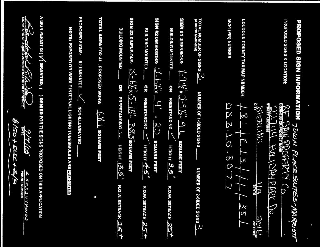
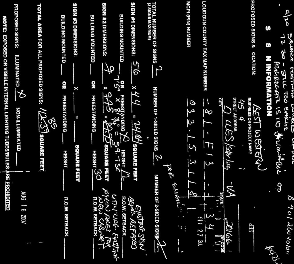
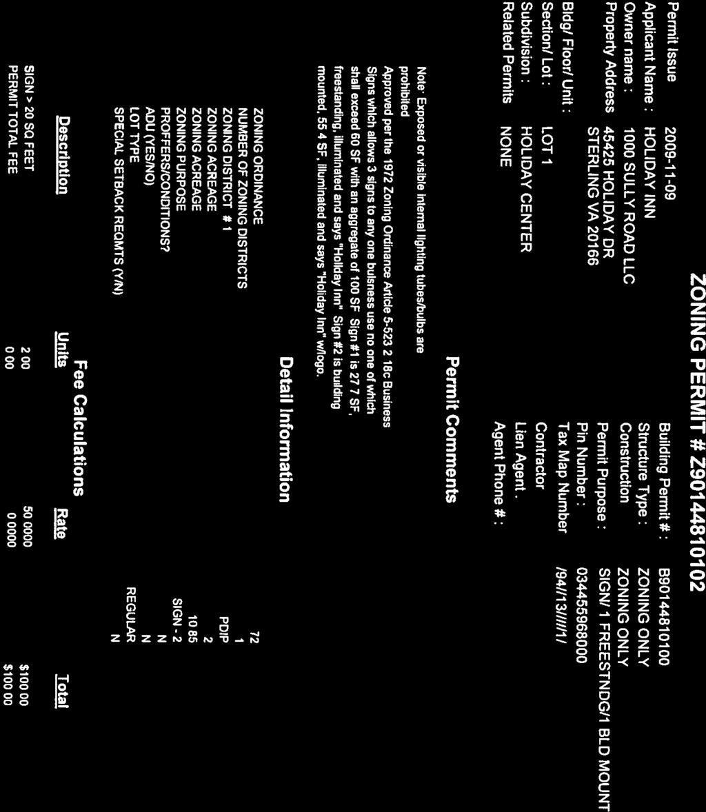
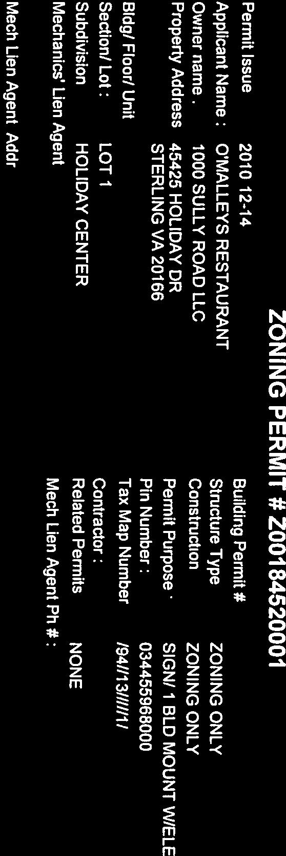
1 County of Loudoun Department of Planning MEMORANDUM DATE: May 30, 2014 TO: FROM: Ginny Rowen, Project Manager Land Use Review Pat Giglio, Planner III Community Planning SUBJECT: ZMOD , Dulles North Business Park Comprehensive Sign Plan, 2 nd Referral The applicant, 100 Sully Road, L.L.C., is requesting a Zoning Ordinance Modification (ZMOD) to permit a Comprehensive Sign Plan for the hospitality service uses located within Dulles North Business Park pursuant to the provisions of the 1972 Zoning Ordinance. The proposed sign plan is intended to provide a wayfinding system for visitors and patrons of the three hotels and conference training center located within the commercial/business center. The subject site is located within the Ashburn Community of the Suburban Policy Area in an area planned for Route 28 Core business uses. The site is also located within the Route 28 Highway Transportation Improvement District (Route 28 Tax District), and is zoned PD-IP (Planned Development Industrial Park). The Applicant has responded to Community Planning s first referral comments dated March 5, The proposal has remained virtually unchanged, though the applicant in response to referral comments has committed to signage illumination levels in conformance with the 1972 Zoning Ordinance and will provide landscaping at the base of the proposed monument signs. In general, staff finds the location and design of the proposed directional monument signs are in conformance with Plan policies. However, as noted in the first referral, the proposed rehabilitation of the existing 30 foot high Best Western pylon sign and construction of the proposed 27 foot high Holiday Inn pylon sign are not supported by Plan policies. The existing and proposed pylon signs are out of scale and proportion with the existing buildings and the overall design, architecture and landscape theme envisioned by the Plan for the Route 28 Core area, which is planned to develop as a premiere office and business corridor. Staff recommends the applicant eliminate the proposed pylon signs from the sign plan since they are not supported by Plan policies. Attachment 1a A-1
2 ZMOD , Dulles North Business Park Comprehensive Sign Plan Community Planning 2 nd Referral May 30, 2014 Page 2 Staff finds the request for the proposed directional monument signs are in conformance with the policies and design guidelines of the Revised General Plan and Retail Plan for the Route 28 Core area. However, Staff has identified outstanding issues with the proposed pylon signs, which are not in keeping with the design aesthetics envisioned for the Route 28 Core by the Plan. Staff recommends approval of the Zoning Modification request for the Dulles North Business Park Comprehensive Sign provided that the pylon signs are eliminated from the proposal. cc: Julie Pastor, FAICP, Director Cynthia L. Keegan, AICP, Program Manager, Community Planning (via ) A-2
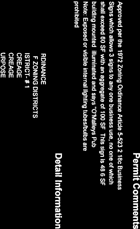
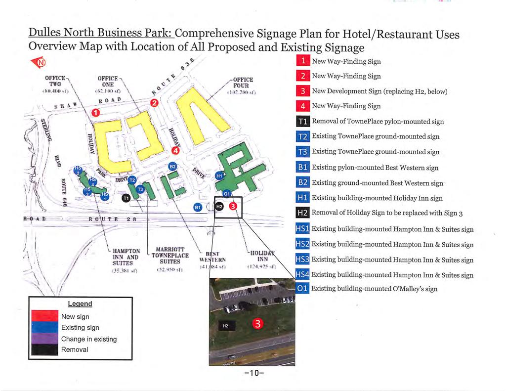
3 County of Loudoun Department of Planning MEMORANDUM DATE: March 5, 2013 TO: FROM: Ginny Rowen, Project Manager Land Use Review Pat Giglio, Planner III Community Planning SUBJECT: ZMOD , Dulles North Business Park Comprehensive Sign Plan EXECUTIVE SUMMARY 100 Sully Road, L.L.C., the applicant, is requesting a Zoning Ordinance Modification (ZMOD) to permit a Comprehensive Sign Plan for the hospitality service uses located within Dulles North Business Park pursuant to the provisions of the 1972 Zoning Ordinance. The proposed sign plan is intended to provide a wayfinding system for visitors and patrons of the three hotels and conference training center located within the commercial/business center. The acres subject site is located in the southwest quadrant of the intersection of Route 28 (Sully Road) and Sterling Boulevard within the Ashburn Community of the Suburban Policy Area. The site is located within the Route 28 Highway Transportation Improvement District (Route 28 Tax District), and is zoned PD-IP (Planned Development Industrial Park). The proposed Dulles North Business Park Comprehensive Sign Plan proposes the construction of three directional monument signs, the rehabilitation of the existing Best Western pylon sign and the construction of a 27 foot tall Holiday Inn pylon sign fronting on Route 28. Overall, staff finds the construction of the three proposed directional monument signs are in general conformance with Plan policies. However, the proposed pylon signs are out of scale and proportion with the existing buildings and do not contribute to the overall architectural and landscape theme of the corridor as envisioned in the Plan. Staff is not able to recommend approval of the Zoning Modification request at this time. Staff requests additional information regarding landscaping and lighting for the three proposed directional monument signs to ensure compliance with Plan A-3
4 ZMOD , Dulles North Business Park Comprehensive Sign Plan Community Planning 1 st Referral March 5, 2013 Page 2 policies. Staff recommends the applicant eliminate the proposed pylon signs from the sign plan since they are not supported by Plan policies. BACKGROUND The Dulles North Business Park, consists of six parcels containing approximately acres zoned PD-IP (Planned Development Industrial Park), located on the west side of Shaw Road (Route 647) south of the Sterling Boulevard and Route 28 interchange. The proposed Comprehensive Sign Plan is designed to improve way-finding to the hospitality service business uses within the commercial business center which include Holiday Inn Dulles and O Malley s Pub, the Executive Conference and Training Center, TownePlace Suites Dulles and the Best Western Dulles. These hospitality service business uses while visible from Route 28, as well as Sterling Boulevard are only accessible from two entrances on Shaw Road, now that Route 28 has been developed as a limited access highway. The Comprehensive Sign Plan proposes to modify Section c of the 1972 Zoning Ordinance with respect to: maximum aggregate sign area, maximum number of signs, maximum area of any one sign, and setback from public streets. The applicant has provided: (i) a detailed Comprehensive Sign Plan that includes the parameters for the size, number, design, materials, color, location, and illumination of signs; (ii) a sign plan depicting the location of the proposed signs on the site; and (iii) a sign matrix providing a comparison of the proposed plan to existing regulations. COMPLIANCE WITH THE COMPREHENSIVE PLAN The subject site is located within the Sterling Community of the Suburban Policy Area and is governed by the Route 28 Core policies outlined in Loudoun County s Revised General Plan (Revised General Plan, Chapter 6, Suburban Community Boundaries Map and Route 28 Corridor Plan Planned Land Use Map). The retail policies of the Countywide Retail Plan Amendment (Retail Plan) also apply. The subject site is also located within the Route 28 Highway Transportation Improvement District (Route 28 Tax District). COMPATIBLITY The subject site is designated as Route 28 Core which supports the development of high quality, high intensity office buildings containing four or more stories in the form of an Office Cluster or Mixed-Use Office Centers (Revised General Plan, Chapter 6, Route 28 Corridor Plan, Route 28 Core Policies, Policy 1 and Office Cluster Policies Policy 1). Office and flex use developments within the Route 28 Corridor should be designed with a park-like atmosphere, exhibiting a high curb appeal through the use of extensive landscaping and coordinated building architecture (Revised General Plan, Chapter 6, Route 28 Corridor Plan, Design, General Policy 8). Additionally, Plan policies state that within the Route 28 Core, hotels should include multi-story, large scale, mid-priced, upscale, and/or luxury full service hotels targeted to business and/or leisure travelers (Revised General Plan, Chapter 6, Route 28 Corridor Plan, Route 28 Core Policies, Policy 4 & 5). A-4
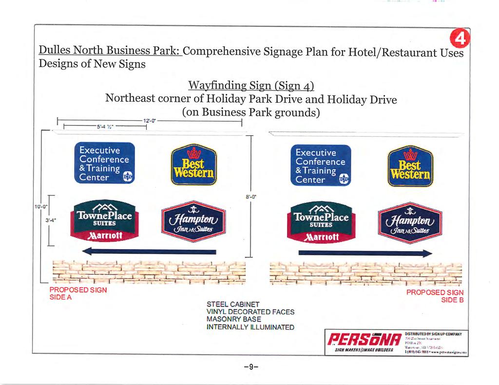
5 ZMOD , Dulles North Business Park Comprehensive Sign Plan Community Planning 1 st Referral March 5, 2013 Page 3 The following guidance for Office Clusters and Mixed-Use Office Centers within the Route 28 Core area offers suggestions for signage that may be appropriate within a campus setting like the The Dulles North Business Park. Signage standards include the following: 1. Visitors and residents should be able to locate and identify major attributes of a development through a unified signage concept; 2. Signage should contribute to the overall architectural and landscape theme; 3. Signage should be used to clearly identify public versus private/residential areas; and 4. Streetscape signage should be appropriately scaled for pedestrians (Revised General Plan, Chapter 6, Route 28 Corridor Plan, Office Cluster and Mixed- Use Office Center Design Standards, Signage Standards). The policies of the Retail Plan further explain that signs for commercial centers should be developed as an integral part of the overall center design and that a unified graphic design scheme is strongly encouraged (Retail Plan, Signs and Lighting Policy 1). The proposed Comprehensive Sign Plan program for the hospitality service business uses within the Dulles North Business Park includes three directional monument signs, removal of the existing Holiday Inn freestanding sign fronting Route 28 (Sully Road) and replacement with a larger 27 foot tall pylon sign, and the replacement of the blank north face of the existing Best Western pylon sign fronting Route 28 (Sully Road) with a matching logo sign to create a double-sided sign. The applicant has provided renderings to illustrate the proposed signage in addition to detailed guidelines and provisions. No changes to any of the existing building-mounted signs is proposed, though they have been included in the Plan for illustrative purposes. Staff has the following comments and recommendations regarding specific sign types. Directional Monument Signs The Comprehensive Sign Plan proposes three directional monument signs, two located at the entrances along Shaw Road and one internal to the development which serve as wayfinding system for visitors. The directional monument signs vary in size from 6 feet to 12 feet in length to 9 feet to 10 feet in height depending on their location and feature the names of the three hotels and the conference center. The directional monument signs rest on masonry stone bases and will be internally illuminated, though no information on the intensity of lighting has been provided. In general the size, scale, design, materials, color and composition of the directional monument signs complement the landscaping as well as the existing building-mounted signs and architecture of the buildings within Dulles North Business Park. The three proposed signs are consistent with other approved sign plans and existing monument signs in the Route 28 Core. The submitted application does not provide information on the intensity of lighting for the proposed internally illuminated signs. The applicant should commit to lighting A-5

6 ZMOD , Dulles North Business Park Comprehensive Sign Plan Community Planning 1 st Referral March 5, 2013 Page 4 which is in conformance with the policies of the Plan (see below) and standards within the Zoning Ordinance. View north of existing directional sign on Shaw Road. A site visit by staff revealed that the proposed directional monument signs will be located on existing sloping terrain so that more of the stone base of the sign may be visible than is depicted in the renderings included in the sign plan. Staff recommends the installation of landscaping around the base of the directional monument entrance sign to better blend them into the topography of the site and the surrounding landscape. The use of native plant species of low-lying shrubbery and/or flowering plants is encouraged. Analysis Overall, the three proposed directional monument signs appear uniform in size, scale, design, materials, color, composition and complement the architecture and landscape theme within the commercial/business center and are consistent with the Revised General Plan. However, Staff requests additional information regarding landscaping around the base of the signs. Staffs recommends a condition of approval to include landscaping around the signs as well as a commitment to long-term maintenance of the landscaping and signs. Additionally, Staff recommends information regarding the intensity of lighting and times of illumination be provided to A-6
.")
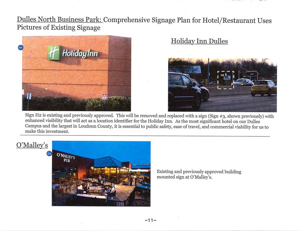
7 ZMOD , Dulles North Business Park Comprehensive Sign Plan Community Planning 1 st Referral March 5, 2013 Page 5 further evaluate light trespass and impacts on adjoining properties and streets (see below). Pylon Signs The Dulles North Business Park, is an existing commercial/business center which has evolved over the past 30 years, however, due to its prominent location with frontage on Route 28, Sterling Boulevard and Shaw Road, the proposed Comprehensive Sign Plan should emphasize a quality design that is consistent with the Route 28 Core and Retail Plan policies. Within the Route 28 Corridor the buildings are to be the predominant feature framing the roadways and signage is intended to complement the buildings. A nearby example is the Comprehensive Sign Plan approved for Spring Hill Suites (ZMOD ), that has buildingmounted signs which are proportionate to the scale and size of the multi-story building which has frontage on Route 28. Additionally it should be noted that the ground-mounted monument signs for the hotel are similar to those being proposed in the current application. View north of existing pylon sign from Route 28 (Sully Road). The Dulles North Business Park Comprehensive Sign Plan proposes to rehabilitate the existing pylon sign for the Best Western fronting Route 28 (Sully Road) by replacing the blank north face with a matching logo to create a doublesided sign. The existing pylon sign is approximately 30 feet in height and is internally illuminated. The existing pylon sign is similar in design to a billboard sign, current Plan policies do not support these types of signs as they do not contribute to the overall architectural and landscape theme of the corridor A-7
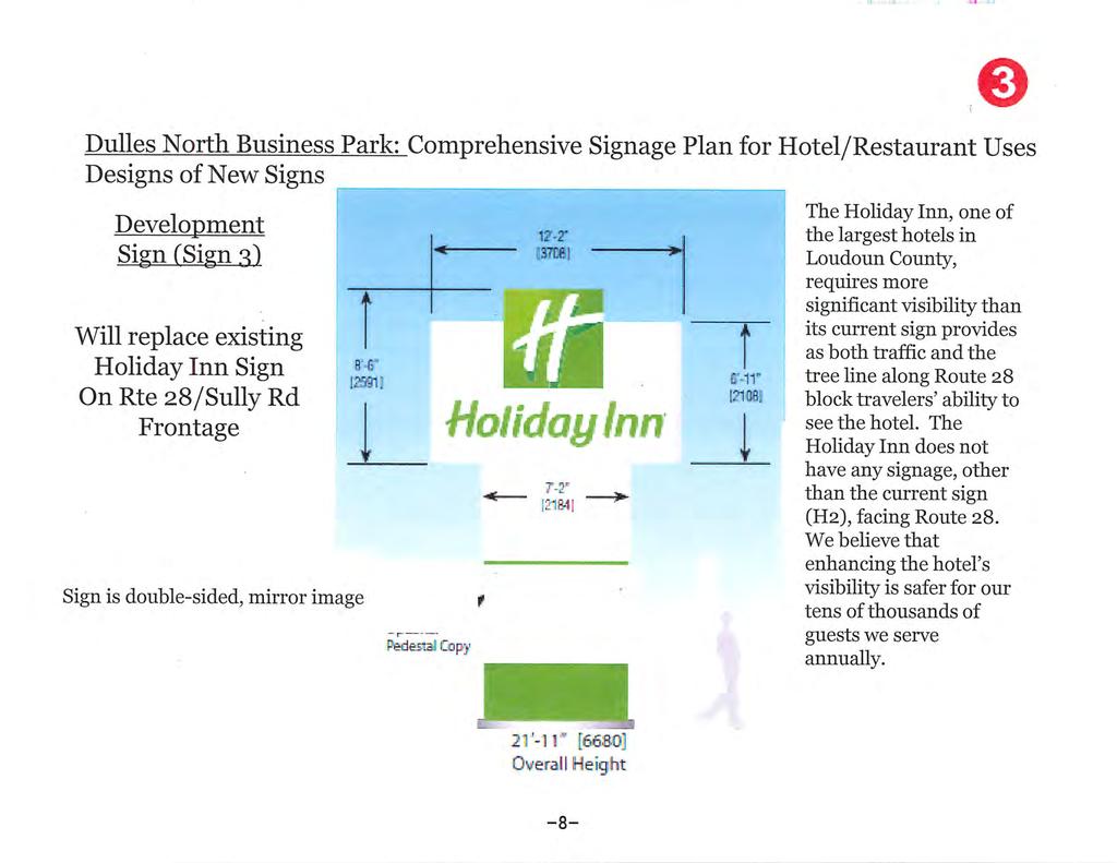
8 ZMOD , Dulles North Business Park Comprehensive Sign Plan Community Planning 1 st Referral March 5, 2013 Page 6 (Revised General Plan, Chapter 6, Route 28 Corridor Plan, Office Cluster and Mixed-Use Office Center Design Standards, Signage Standards). The Plan identifies the area adjacent to Route 28 for high quality, high intensity, multi-story office developments which reflect the areas position as a premier business corridor (Revised General Plan, Chapter 6, Route 28 Corridor Plan, Route 28 Core Policies, text). Rehabilitation of the sign would not be in conformance with Plan policies. The Sign Plan also proposes the removal of the existing 9 foot tall free-standing Holiday Inn sign fronting Route 28 (Sully Road) and replacement with a larger pylon sign. The proposed pylon sign is approximately 27 feet in height and 12 feet in length and will be internally illuminated. The proposed replacement Holiday Inn pylon sign is similar in height to the existing Best Western sign and is designed to provide visibility to motorist on Route 28 (Sully Road). Like the existing Best Western Sign, Plan policies do not support these types of pylon signs within the Route 28 Corridor because they are out of scale and proportion with the surrounding buildings and do not contribute to the overall architecture and landscape theme within the commercial/business center or the premiere business community character envisioned for the corridor. Plan policies do not support the rehabilitation of the existing Best Western pylon sign or the construction of the proposed 27 foot high Holiday Inn pylon sign on the subject site. Analysis Collectively the location, quality, and clarity of signs define the general perception of a business or commercial corridor and its surrounding community. The Plan identifies the area adjacent to Route 28 for high quality, high intensity, multi-story office developments which reflect a premier business corridor. The proposed rehabilitation of the existing Best Western pylon sign and the construction of the proposed 27 foot tall Holiday Inn pylon sign do not complement the architecture and landscape theme of the development or the corridor and are not supported by Plan policies for the Route 28 Corridor. Staff finds the proposed pylon signs are out of scale and proportion with the surrounding buildings and detract from the overall architecture and landscape theme of the existing commercial/business center and the County s objectives for the development of the Route 28 Corridor as a premiere business corridor. Staff recommends the applicant eliminate the proposed pylon signs from the sign plan since they are not supported by Plan policies. Lighting The Revised General Plan promotes the use of lighting for convenience and public safety without the nuisance associated with light pollution and intrusive light trespass that detracts from the beauty and view of the night sky (Revised General Plan, Chapter 5, Lighting and Night Sky Policy 1). The Retail Plan also A-8
9 ZMOD , Dulles North Business Park Comprehensive Sign Plan Community Planning 1 st Referral March 5, 2013 Page 7 specifies that all lighting should be designed to reduce glare and spillage of light onto adjoining properties and streets (Retail Plan, Signs and Lighting, Policy 2, pg. 21). The applicant as part of the current Comprehensive Sign Plan for the Dulles North Business Park is purposing to internally illuminate the three proposed directional monument signs and two pylon signs. However, the application lacks adequate information specifying the intensity and times of illumination to control light trespass and light pollution on adjoining properties and streets. In particular, times of illumination, intensity of lighting, and a statement of justification that the proposed lighting is the minimum necessary for the operation of the hospitality service uses should be provided by the applicant. The issue of intrusive light trespass and light pollution created by the proposed sign plan should also be addressed. Analysis Light levels and the hours of use have not been specified for any of the signs. Given the lack of information regarding lighting, the application does not offer sufficient assurances regarding protection of the night sky. Staff recommends that information regarding intensity of lighting and times of illumination be provided to further evaluate light trespass and impacts on adjoining properties and streets. RECOMMENDATIONS The proposed Dulles North Business Park Comprehensive Sign Plan proposes the construction of three directional monument signs, the rehabilitation of the existing Best Western pylon sign and the construction 27 foot high Holiday Inn pylon sign fronting on Route 28. Staff finds the construction of the proposed three directional monument signs complement the architecture and landscape theme within the commercial/business center as well as the Route 28 Corridor and are consistent with Plan policies. Additional information regarding landscaping and lighting for the proposed directional monument signs is necessary for Staff to complete the analysis of the proposed Comprehensive Sign Plan. However, Staff is not able to recommend approval of the Zoning Modification for the proposed directional monument signs at this time. Plan policies do not support the rehabilitation of the existing Best Western pylon sign or the construction of the proposed 27 foot high Holiday Inn pylon sign on the subject site. Staff finds the proposed pylon signs are out of scale and proportion with the surrounding buildings and detract from the overall architecture and landscape theme of the existing commercial/business center and the County s objectives for the development of the Route 28 Corridor as a premiere business corridor. Staff recommends the applicant eliminate the proposed pylon signs from the sign plan since they are not supported by Plan policies. A-9
10 ZMOD , Dulles North Business Park Comprehensive Sign Plan Community Planning 1 st Referral March 5, 2013 Page 8 Staff would be happy to meet with the applicant to discuss these issues. cc: Julie Pastor, AICP, Director, Planning Cindy Keegan, AICP, Program Manager, Community Planning A-10


11 Attachment 1b A-11
12 A-12
13 A-13
14 A-14
15 A-15

16 A-16
17 A-17
18 A-18
19 A-19
20 A-20

21 A-21


22 A-22


23 A-23


24 A-24

25 A-25
26 Attachment 2 A-26
27 A-27

28 A-28
29 A-29
30 A-30
31 A-31
32 Attachment 3 A-32
33 A-33

34 A-34
35 A-35

36 A-36
37 A-37


38 A-38
39 Attachment 4 A-39
40 A-40
41 A-41
42 A-42
43 A-43
44 A-44
45 A-45
46 A-46
47 A-47
48 A-48
49 A-49
50 A-50
51 A-51
52 A-52
DEVELOPMENT CONTROLS MEDICAL DISTRICT
 6.01. GENERAL DESIGN GUIDELINES A. Site Planning B. Architectural Design C. Medical Facility Signage & Lighting D. Exhibit 48. ARCHITECTURAL DESIGN CONCEPTS 6.02. MEDICAL FACILITY STANDARDS & GUIDELINES
PLANNING COMMISSION AGENDA REPORT NOVEMBER 15, 2012
 PLANNING COMMISSION AGENDA REPORT NOVEMBER 15, 2012 TO: FROM: Members of the Planning Commission Michael Klein, Associate Planner FILE NO.: 120000890 PROPOSAL: APPLICANT: Request for an Administrative
Request Conditional Use Permit (Automobile Repair Garage) Staff Planner Kevin Kemp
 Staff Planner Kevin Kemp") Request Conditional Use Permit (Automobile Repair Garage) Staff Planner Kevin Kemp Location 845 Lynnhaven Parkway GPIN 14963473030000 Election District Rose Hall Site Size 0.40 acre portion of a 6.35 acre
Request Conditional Use Permit (Automobile Repair Garage) Staff Planner Kevin Kemp Location 845 Lynnhaven Parkway GPIN 14963473030000 Election District Rose Hall Site Size 0.40 acre portion of a 6.35 acre
Resolution : Exhibit A. Downtown District Design Guidelines March 2003
 Resolution 03-011: Exhibit A Downtown District Design Guidelines March 2003 DOWNTOWN DISTRICT DESIGN GUIDELINES CITY OF SOUTHLAKE, TEXAS Adopted March 2003 1 DOWNTOWN DISTRICT DESIGN GUIDELINES Adopted
22.15 OUTDOOR ADVERTISING SIGNAGE POLICY
 22.15 OUTDOOR ADVERTISING SIGNAGE POLICY This policy applies to all land where a planning permit is required to construct or display a sign under the provisions of the Kingston Planning Scheme. 22.15-1
The Maryland-National Capital Park and Planning Commission Prince George's County Planning Department Development Review Division
 The Maryland-National Capital Park and Planning Commission Prince George's County Planning Department Development Review Division 301-952-3530 Note: Staff reports can be accessed at www.mncppc.org/pgco/planning/plan.htm.
WHEREAS, after consideration of the evidence presented at the public hearing on September 11, 2008, the Prince George's County Planning Board finds:
 File No.DSDS-648 R E S O L U T I O N WHEREAS, the Prince George's County Planning Board has reviewed DSDS-648 requesting a departure of 571.44 square feet from the maximum permitted sign area of building-mounted
4. INDUSTRIAL 53 CASTLE ROCK DESIGN
 4. INDUSTRIAL 53 CASTLE ROCK DESIGN CASTLE ROCK DESIGN 54 4. INDUSTRIAL Overview Well-designed and attractive industrial centers are the product of blending economic realities with both functional and
PLANNING COMMISSION STAFF REPORT Legislative Item
 PLANNING COMMISSION STAFF REPORT Legislative Item Manufacturing Districts Monument Sign Height Zoning Text Amendment PLNPCM2013-00197 Citywide August 28, 2013 Planning Division Department of Community
Urban Design 9Identity
 Urban Design 9Identity URBAN DESIGN IDENTITY Urban design is about connecting people to their places through the built environment, nature, and overall urban form. Done well, it creates a memorable space
12 January 12, 2011 Public Hearing APPLICANT: TAILWIND DEVELOPMENT GROUP,LLC PROPERTY OWNER: CITY OF VIRGINIA BEACH
 12 January 12, 2011 Public Hearing APPLICANT: TAILWIND DEVELOPMENT GROUP,LLC PROPERTY OWNER: CITY OF VIRGINIA BEACH STAFF PLANNER: Faith Christie REQUEST: Conditional Change of Zoning (from PD-H1 Planned
CHAPTER FIVE COMMUNITY DESIGN
 CHAPTER FIVE COMMUNITY DESIGN CHAPTER FIVE - COMMUNITY DESIGN Assumptions Frazier Park and Lebec have historically developed according to different patterns of spatial form. While both communities are
FINDINGS FOR APPROVAL SPEX and SPMI , Goose Creek Gardens and Pavilion
 FINDINGS FOR APPROVAL SPEX-2015-0028 and SPMI-2015-0011, Goose Creek Gardens and Pavilion 1. The proposed special exception use is consistent with the Comprehensive Plan. Specifically, the Revised General
Future Five. Design/ Development Guidelines. January 2008 Amended June 08 per City Council motion
 Future Five Design/ Development Guidelines January 2008 Amended June 08 per City Council motion 5-Points Design Guidelines Table of Contents I. Introduction 3 II. Area boundaries 4 III. Review Process
Narcoossee Roadway Corridor
 Community Meeting Narcoossee Roadway Corridor April 5, 2012 Meeting Agenda Purpose of Meeting Continuation of Study Update Process (Previous Meetings Oct. & Nov., 2011) Tonight s Objective Review Proposals
4.500 Preston Road Overlay District
 Section 4.500 Preston Road Overlay District 2004 Zoning Ordinance 4.500 Preston Road Overlay District (ZC 98-29; Ordinance No. 98-9-12) 4.501 Purpose To provide appropriate design standards for the use
CHAPTER SPECIAL PURPOSE AND OVERLAY ZONING DISTRICTS
 Special Purpose and Overlay Zoning Districts 106.28.010 CHAPTER 106.28 - SPECIAL PURPOSE AND OVERLAY ZONING DISTRICTS SPECIAL PURPOSE AND OVERLAY ZONING DISTRICTS Sections: 106.28.010 - Purpose 106.28.020
Planning Commission Staff Report June 5, 2008
 Owner/Applicant Taylor Village Sacramento Investments Partners, LP c/o Kim Whitney 1792 Tribute Road #270 Sacramento, CA 95815 Staff Recommendation Planning Commission Staff Report Project: File: Request:
CHAPTER 5 Public Realm Improvements
 5.1 OVERVIEW This chapter focuses on the public realm, that is, spaces within and directly adjacent to public rights-of-way (ROWs), including streets, Oso Creek, the rail corridor, and the freeway edge.
6 November 13, 2013 Public Hearing APPLICANT: CAH HOLDINGS, LLC
 6 November 13, 2013 Public Hearing APPLICANT:, LLC PROPERTY OWNER: LC REALTY, LLC STAFF PLANNER: Kevin Kemp REQUEST: Conditional Use Permit (Automated Car Wash) ADDRESS / DESCRIPTION: 3565 Holland Road
Chapter SAR, SENSITIVE AREA RESORT ZONE
 Moab Municipal Code Chapter 17.32 SAR, SENSITIVE AREA RESORT ZONE Page 1 of 8 Sections: 17.32.010 Objectives and characteristics. 17.32.020 Use regulations. Chapter 17.32 SAR, SENSITIVE AREA RESORT ZONE
APPENDIX C. Architectural and Environmental Design Standards. Environmentally sensitive areas should be protected.
 APPENDIX C Architectural and Environmental Design Standards Environmentally Sensitive Areas Goal A. Environmentally sensitive areas should be protected. Development, such as roads, houses, and other structures,
AWH REPORT OF THE PLANNING AND DEVELOPMENT DEPARTMENT FOR APPLICATION FOR REZONING ORDINANCE TO PLANNED UNIT DEVELOPMENT
 AWH REPORT OF THE PLANNING AND DEVELOPMENT DEPARTMENT FOR APPLICATION FOR REZONING ORDINANCE TO PLANNED UNIT DEVELOPMENT MAY 8, 2014 The Planning and Development Department hereby forwards to the Planning
Colerain Township report to. Hamilton County Regional Planning Commission. December 2, 2010, 1:00PM. t a f f r e p o r t
 Colerain Township report to Hamilton County Regional Planning Commission December 2, 2010, 1:00PM Preliminary Plan: Case No.: ZA2001-04, Forevergreen Prepared By: Amy Bancroft, Land Use Planner t a f f
FLORIN ROAD CORRIDOR Site Plan and Design Review Guidelines Checklist
 FLORIN ROAD CORRIDOR Site Plan and Design Review Guidelines Checklist Applicant s Name: Project Address: Phone: Email: Applicant shall fill out the design guidelines checklist for all guidelines applicable
Seneca Meadows. Block 4 Locate office, technology, and medical development adjacent to I Screen views of garage structures from I-270.
 Seneca Meadows Seneca Meadows has an industrial park in its southern end and a mixed-use employment area planned for the north end. The district benefits from extensive I-270 visibility, stream valley
VILLAGE OF SKOKIE Design Guidelines for Mixed-Use Districts NX Neighborhood Mixed-Use TX Transit Mixed-Use CX Core Mixed-Use
 VILLAGE OF SKOKIE Design Guidelines for Mixed-Use Districts NX Neighborhood Mixed-Use TX Transit Mixed-Use CX Core Mixed-Use TABLE OF CONTENTS CHAPTER 1 SITE DESIGN Purpose 1 CHAPTER 2 SITE DESIGN Streetscape
CHAPTER 13 DESIGN GUIDELINES
 CHAPTER 13 DESIGN GUIDELINES Section 1300.00 Section 1300.01 Design Guidelines Purpose The purposes of this section are to: A. The purpose of this Section is to establish procedures and standards to serve
DRAFT DESIGN GUIDELINES
 IHZ Booklet #7 May 6, 2010 DRAFT DESIGN GUIDELINES CANTERBURY 7 Overview During the recent planning process for the Plan of Conservation and Development community character was identified as an important
The Maryland-National Capital Park and Planning Commission Prince George's County Planning Department Development Review Division
 The Maryland-National Capital Park and Planning Commission Prince George's County Planning Department Development Review Division 301-952-3530 Note: Staff reports can be accessed at www.mncppc.org/pgco/planning/plan.htm.
City of Fairfax, Virginia City Council Work Session
 City of Fairfax, Virginia City Council Work Session Agenda Item # 12a City Council Meeting 5/8/2018 TO: FROM: SUBJECT: Honorable Mayor and Members of City Council Robert Sisson, City Manager Request of
COLERAIN TOWNSHIP ZONING COMMISSION Regular Meeting Tuesday, October 18, :00 p.m.
 COLERAIN TOWNSHIP ZONING COMMISSION Regular Meeting Tuesday, October 18, 2016-6:00 p.m. Colerain Township Government Complex 4200 Springdale Road - Cincinnati, OH 45251 1. Meeting called to order. Pledge
Welcome. Walk Around. Talk to Us. Write Down Your Comments
 Welcome This is an information meeting introducing the applications for proposed redevelopment of the Yorkdale Shopping Centre site at 3401 Dufferin Street and 1 Yorkdale Road over the next 20+ years,
Design Review Application *Please call prior to submittal meeting to determine applicable fees*
 CITY OF EAGLE 660 E. Civic Lane, Eagle, ID 83616 Phone#: (208) 939-0227 Fax: (208) 938-3854 Design Review Application *Please call prior to submittal meeting to determine applicable fees* FILE NO.: CROSS
D. Landscape Design. 1. Coverage Intent: To provide adequate landscaping materials that enhance the appearance of development projects.
 D. Landscape Design The standards and guidelines in this section give design guidance for the landscaping components of industrial and office projects. City regulations require that all landscaping be
Development and Engineering Services
 To: From: Regular Meeting Date: June 11, 2018 Development and Engineering Services Subject: Development Permit Application No. DP 2018-002 Proposed free-standing restaurant with a drive-thru and patio
PC RESOLUTION NO ARCHITECTURAL CONTROL (AC)
") PC RESOLUTION NO. 16-07-26- ARCHITECTURAL CONTROL (AC) 15-035 A RESOLUTION OF THE PLANNING COMMISSION OF THE CITY OF SAN JUAN CAPISTRANO, CALIFORNIA APPROVING ARCHITECTURAL CONTROL (AC) 15-035, INN AT
PC RESOLUTION NO. 16-07-26- ARCHITECTURAL CONTROL (AC) 15-035 A RESOLUTION OF THE PLANNING COMMISSION OF THE CITY OF SAN JUAN CAPISTRANO, CALIFORNIA APPROVING ARCHITECTURAL CONTROL (AC) 15-035, INN AT
City of San Juan Capistrano Agenda Report
 ITEM F1 City of San Juan Capistrano Agenda Report TO: FROM: DATE: SUBJECT: Planning Commission Development Services Department Submitted and Reviewed by Sergio Klotz, Al~ rector~ Prepared by Mathew Evans,
Location and Field Inspection: History: Master Plan Recommendation:
 R E S O L U T I O N WHEREAS, the Prince George s County Planning Board has reviewed Special Permit Application No. SP-130008, Sudsville Laundry, requesting a special permit to construct an addition and
CASE NUMBER: 16SN0701 APPLICANT: Hanky, LLC
 STAFF S ANALYSIS AND RECOMMENDATION Planning Commission (CPC) Public Hearing Date: MAY 17, 2016 CPC Time Remaining: 100 DAYS Applicant s Agent: DANIEL L. CASKIE (804-569-7060) Applicant s Contact: MICHAEL
SUBJECT: PREDEVELOPMENT PLAN REVIEW OF PROJECT LOCATED AT 2632 EAST WASHINGTON BOULEVARD ('ST. LUKE MEDICAL CENTER')
") TO: FROM: Honorable Mayor and City Council Planning & Community Development Department SUBJECT: PREDEVELOPMENT PLAN REVIEW OF PROJECT LOCATED AT 2632 EAST WASHINGTON BOULEVARD ('ST. LUKE MEDICAL CENTER')
TO: FROM: Honorable Mayor and City Council Planning & Community Development Department SUBJECT: PREDEVELOPMENT PLAN REVIEW OF PROJECT LOCATED AT 2632 EAST WASHINGTON BOULEVARD ('ST. LUKE MEDICAL CENTER')
DEVELOPMENT DESIGN GUIDELINES
 DEVELOPMENT DESIGN GUIDELINES Approved by Surrey City Council January 26, 2004 Campbell Heights Business Park - Development Design Guidelines TABLE OF CONTENTS 1.0 DEVELOPMENT CONCEPT... 1 2.0 DESIGN OBJECTIVES...
Section 1. Executive Summary
 Executive Summary (This page left blank intentionally) Executive Summary Background Economic growth in southern Leavenworth County over the past decade has been strong. As both the number of business and
Response: The public school use, including the SWM facility, is within the R-1 District.
 Loudoun County School Board Dulles North Elementary School (ES-31) CMPT 2017-0006 and SPMI 2017-0015 First Response to Referral Comments Zoning Administration Comments dated October 2, 2017 Comment 1:
A. Background Summary of Existing Challenges and Potential Possibilities. 1. Summary of Existing Assets and Potential Opportunities
 A. Background 1 A Main Street Master Plan Study was performed and completed in October of 2007. The study was initiated to review current land uses and development patterns along Main Street, from Parrish
SECTION 1000 HIGHWAY CORRIDOR OVERLAY DISTRICT REGULATIONS
 SECTION 1000 HIGHWAY CORRIDOR OVERLAY DISTRICT REGULATIONS 1001.00 INTENT AND PURPOSE... 1000-1 1002.00 CLASSIFICATIONS... 1000-1 1003.00 DEVELOPMENT STANDARDS TABLES Page 1003.01 Buffer Requirements...................................
EXECUTIVE SUMMARY DRAFT CHAPTER 1 INTRODUCTION EXECUTIVE SUMMARY
 CHAPTER 1 EXECUTIVE SUMMARY INTRODUCTION Through the joint efforts of the City of Tulsa planning staff and the Land Services division of Indian Nations Council of Governments (INCOG), the Berryhill Land
Small Area Plan. South Gateway
 Small Area Plan Adopted May 12, 2008 South Gateway Purpose. The South Gateway Small Area Plan defines the City s expectations for the future of the southern entrance to the City at Interstate 85 and Highway
Hockessin Community Redevelopment Plan
 Hockessin Community Redevelopment Plan 3.1 Introduction The Community Redevelopment Plan for the Village of Hockessin is the result of the people s vision for a distinct village center that serves as the
Corridor Identity. Section 9. Introduction. Corridor Guiding Principles
 Corridor Identity An attractive and healthy community is a critical element of a quality place, and the design of quality places is a balance between environmental, economic, and social considerations.
Policies and Code Intent Sections Related to Town Center
 Policies and Code Intent Sections Related to Town Center The Town Center Vision is scattered throughout the Comprehensive Plan, development code and the 1994 Town Center Plan. What follows are sections
REZONING APPLICATION MPD SUPPLEMENT
 REZONING APPLICATION MPD SUPPLEMENT For Staff Use Only: DATE/TIMESTAMP: ZA# RECEIVED BY: The intent of the Master Planned District (MPD) designation is to allow flexibility in the design and construction
CHAPTER 21 NC-PUD NEIGHBORHOOD COMMERCIAL PUD DISTRICT
 CHAPTER 21 NC-PUD NEIGHBORHOOD COMMERCIAL PUD DISTRICT Section 21.1. Title and Purpose. The Neighborhood Commercial Planned Unit Development District, designated the, is intended for commercial uses of
The Highway Overlay District applies to an area within the City of Papillion's zoning jurisdiction described as:
 ARTICLE XXVIII. HOD Highway Overlay District 205-164. Intent. The Highway Overlay District recognizes the strategic importance of the Highway 370 corridor as an entrance to Papillion from Interstate 80
REQUEST Current Zoning: O-15(CD) (office) Proposed Zoning: TOD-M(CD) (transit oriented development mixed-use, conditional)
 (office) Proposed Zoning: TOD-M(CD) (transit oriented development mixed-use, conditional)") Rezoning Petition 2016-117 Zoning Committee Recommendation January 4, 2017 REQUEST Current Zoning: O-15(CD) (office) Proposed Zoning: TOD-M(CD) (transit oriented development mixed-use, conditional) LOCATION
Rezoning Petition 2016-117 Zoning Committee Recommendation January 4, 2017 REQUEST Current Zoning: O-15(CD) (office) Proposed Zoning: TOD-M(CD) (transit oriented development mixed-use, conditional) LOCATION
PLAN RECOMMENDATIONS. WSISAP Goals LU-1: Land Use T-2: Transportation US-3: Utility Services CC-4: Community Character WSI-49. Plan Recommendations
 5 WSISAP Goals LU-1: Land Use T-2: Transportation US-3: Utility Services CC-4: Community Character PLAN RECOMMENDATIONS WSI-49 5 PLAN RECOMMENDATIONS The Washburn Switch Interchange Small Area Plan is
Planning Districts INTRODUCTION
 INTRODUCTION To facilitate detailed examination of development prospects for all areas of the community, Delano has been divided into 14 planning districts. The location of these planning districts is
CHAPTER 2: FUTURE LAND USE CONCEPTS
 CHAPTER 2: FUTURE LAND USE CONCEPTS INTRODUCTION The future land use concepts presented in this chapter are an expression of community support for a viable and vital US 50 Corridor. Land use recommendations
Town of Portola Valley General Plan. Nathhorst Triangle Area Plan
 Town of Portola Valley General Plan Amended December 10, 1997 Table of Contents Introduction... 1 Planning Area... 1 Objectives... 2 Principles... 2 Standards... 4 Description... 4 Community Commercial...
5.1.1 The streetscape along US Highway 64 (Brevard Road); and, The built environment within new residential developments; and,
; and, The built environment within new residential developments; and,") Article 5. Landscaping 5.1 Purpose The Town of Laurel Park s landscape standards are designed to create a beautiful, aesthetically pleasing built environment that will complement and enhance community
Article 5. Landscaping 5.1 Purpose The Town of Laurel Park s landscape standards are designed to create a beautiful, aesthetically pleasing built environment that will complement and enhance community
4.9 Mendocino Avenue Corridor Plan Design Guidelines
 4.9 Mendocino Avenue Corridor Plan Design Guidelines The Mendocino Avenue Corridor Plan addresses the area between College Avenue and Steele Lane. Mendocino Avenue is a busy arterial that runs parallel
BOARD OF SUPERVISORS PUBLIC HEARING STAFF REPORT. Stone Ridge East Commercial, LLC
 Date of Hearing: May 10, 2017 #6 BOARD OF SUPERVISORS PUBLIC HEARING STAFF REPORT SUBJECT: ELECTION DISTRICT: SPEX-2016-0058, Community Corner Dulles CRITICAL ACTION DATE: May 10, 2017 STAFF CONTACTS:
STAFF REPORT DEVELOPMENT COMMISSION ZONING MEETING CITY OF COLUMBUS, OHIO JANUARY 10, 2019
 STAFF REPORT DEVELOPMENT COMMISSION ZONING MEETING CITY OF COLUMBUS, OHIO JANUARY 10, 2019 5. APPLICATION: Z18-063 Location: 4053 WEST BROAD STREET (43228), being 6.42± acres located at the southeast corner
ARLINGTON COUNTY, VIRGINIA
 ARLINGTON COUNTY, VIRGINIA County Board Agenda Item Meeting October 15, 2005 DATE: September 28, 2005 SUBJECT: Request to Advertise the adoption of the 2005 Clarendon Sector Plan C. M. RECOMMENDATION:
ADOPTED AT NOVEMBER 15, 2012 PACC MEETING
 ADOPTED AT NOVEMBER 15, 2012 PACC MEETING STAFF MEMORANDUM TO PACC-TECH TO: PACC-Tech FROM: Elaine K. Echols, AICP, Missy Creasy, AICP, and Julia Monteith, AICP TOPIC: Review of Area B Recommendations
11 March 9, 2011 Public Hearing APPLICANT: BUDDHIST EDUCATION CENTER OF AMERICA DONG HUNG TEMPLE, INC. PROPERTY OWNER: MOY FAMILY, LLC
 11 March 9, 2011 Public Hearing APPLICANT: BUDDHIST EDUCATION CENTER OF AMERICA DONG HUNG TEMPLE, INC. PROPERTY OWNER: MOY FAMILY, LLC REQUEST: Conditional Use Permit for Religious use STAFF PLANNER: Karen
D E S I G N R E V I E W B OA R D
 Agenda Report City of Great Falls D E S I G N R E V I E W B OA R D February 28, 2011 C O N T R A C T F L O O R I N G N EW B U I L D I N G Case Number DRB2011-2 Applicant Steve L Heureux (LPW Architects)
PROPOSED DEVELOPMENT CONCEPTS
 MEMORANDUM To Planning and Zoning Commission From Sally Vecchio, Ass t Town Mgr, Community Development Date November 9, 2011 Re Revised Lot 61 Design Concept work session SUMMARY Bob Ballard and Rick Daugherty
CITY OF MERCER ISLAND DESIGN COMMISSION STAFF REPORT
 CITY OF MERCER ISLAND DESIGN COMMISSION STAFF REPORT Agenda Item: 2 March 9, 2011 Project: Description: Applicant: DSR11-004 The applicant is requesting approval to replace the existing exterior wood framed
Village of Glenview Appearance Commission
 Village of Glenview Appearance Commission STAFF REPORT June 6, 2012 TO: Chairman and Appearance Commissioners FROM: Planning & Economic Development Department CASE #: A2012-044 LOCATION: PROJECT NAME:
Rezoning Petition Pre-Hearing Staff Analysis September 17, 2018
 Rezoning Petition 2017-043 Pre-Hearing Staff Analysis September 17, 2018 REQUEST Current Zoning: R-3 (single family residential), R-17MF (multi-family residential), and CC (commercial center) Proposed
7 November 12, 2014 Public Hearing
 7 November 12, 2014 Public Hearing APPLICANTS & PROPERTY OWNERS: DAVID C. & JUDITH L. MARTIN STAFF PLANNER: Graham Owen REQUEST: Change of Zoning from AG-2 Agricultural to Conditional B-2 Community Business
2 nd & St Paul, LLC and BAH-PLA, LLC
 Community Planning and Development Planning Services 201 W. Colfax Ave., Dept. 205 Denver, CO 80202 p: 720.865.2915 f: 720.865.3052 www.denvergov.org/cpd TO: Denver City Council FROM: Theresa Lucero, Senior
VOLUME II DISTRICT DESIGN GUIDELINES BAILEYS CROSSROADS SEVEN CORNERS
 VOLUME II DISTRICT DESIGN GUIDELINES BAILEYS CROSSROADS SEVEN CORNERS SEPTEMBER 2018 ACKNOWLEDGEMENTS FAIRFAX COUNTY BOARD OF SUPERVISORS Sharon Bulova, Chairman Penelope A. Gross, Vice Chairman - Mason
Staff Report to the North Ogden City Planning Commission
 Staff Report to the North Ogden City Planning Commission SYNOPSIS / APPLICATION INFORMATION Application Request: Concept review on a legislative application to rezone land located at approximately 1750
Official Plan Review: Draft Built Form Policies
 PG.30.1 REPORT FOR ACTION Official Plan Review: Draft Built Form Policies Date: May 15, 2018 To: Planning and Growth Management Committee From: Chief Planner and Executive Director, City Planning Division
Mark-up of the effect of the proposed Bronte Village Growth Area OPA No.18 on the text of section 24, Bronte Village, of the Livable Oakville Plan
 Mark-up of the effect of the proposed Bronte Village Growth Area OPA No.18 on the text of section 24, Bronte Village, of the Livable Oakville Plan Notes: This document is provided for information purposes
INTRODUCTION BACKGROUND. Signage Goals
 V. SIGNAGE Introduction V-1 Sign Design V-2 Sign Content V-5 Facade-Mounted Signs V-6 Multi-Tenant Properties V-7 Externally Lit Signs V-9 Internally Lit Signs V-10 Temporary Signs V-11 Salem Signs V-12
STAFF REPORT. April 30, 2018 May 9, 2018
 PATRICK J. SULLIVAN DIRECTOR City of New Bedford Department of Planning, Housing & Community Development 608 Pleasant St, New Bedford, Massachusetts 02740 Telephone: (508) 979.1500 Facsimile: (508) 979.1575
Town of Cobourg Heritage Master Plan. Statutory Public Meeting
 Town of Cobourg Heritage Master Plan Statutory Public Meeting April 25 th 2016 Presentation Overview 1. Introduction 2. Project background and schedule overview 3. Review of strategic direction content
Appendix D North Road/N. Leroy Street Subarea Plan
 North Road/N. Leroy Street Subarea Plan INTRODUCTION The City of Fenton Master Plan was updated in 1996 and included a subarea plan for the North Leroy Street area of the City. It was recognized at that
STATEMENT OF JUSTIFICATION CLARKSBURG PREMIUM OUTLETS AT CABIN BRANCH NORTH DISTRICT, PHASE
 STATEMENT OF JUSTIFICATION CLARKSBURG PREMIUM OUTLETS AT CABIN BRANCH NORTH DISTRICT, PHASE 1 Southwest Corner of Clarksburg Road and Interstate-270 Clarksburg, Maryland Application for Site Plan #820140160
section five BEAUTIFICATION PLAN
 section five BEAUTIFICATION PLAN BEAUTIFICATION PLAN Section Five Beautification Plan The goal of the Beautification Plan is to improve the Route 8-Sunnyland Corridor in terms of aesthetics and to create
COMMUNITY DESIGN. GOAL: Create livable and attractive communities. Intent
 COMMUNITY DESIGN Intent An attractive, well-designed County will attract quality development, instill civic pride, improve the visual character of the community, and create a strong, positive image for
RESIDENTIAL DISTRICTS
 RESIDENTIAL DISTRICTS The residential district standards have been revised to reflect on-the-ground conditions, while continuing to respect the use patterns established within the neighborhoods. This will
5.1 Site Plan Guidelines
 5. Community Core Guidelines Development of the Community Core will take place by plan of subdivision and site plan approval. It will occur in a phased manner that will reflect the timing of residential
MIDTOWN MIXED-USE VILLAGE. TECHNICAL DATA SHEET COMPONENT C-1 FOR PUBLIC HEARING - PETITION NUMBER Project No RZ1.1. Issued.
 N MIDTOWN MIXED-USE VILLAGE TECHNICAL DATA SHEET COMPONENT C- FOR PUBLIC HEARING - PETITION NUMBER 04-00 Project No. 496 Issued Revised SCALE: " = 0' N 0 0 0 40 RZ. c GENERAL PROVISIONS: a. SITE LOCATION.
3.1 Aesthetics, Light, and Glare
 3.1 3.1.1 Introduction This section describes the existing aesthetics, light, and glare setting and potential effects from project implementation on visual resources and the site and its surroundings.
For any questions or additional information regarding this Plan, please contact The George Washington University at (202)
") This Comprehensive Sign Plan is filed on behalf of The George Washington University. The Plan was prepared by Requity Real Estate Group, LLC and STUDIO39 Landscape Architecture in consultation with Walsh,
This Comprehensive Sign Plan is filed on behalf of The George Washington University. The Plan was prepared by Requity Real Estate Group, LLC and STUDIO39 Landscape Architecture in consultation with Walsh,
14 October 10, 2012 Public Hearing APPLICANT: MPB, INC
 14 October 10, 2012 Public Hearing APPLICANT: MPB, INC PROPERTY OWNER: MUNDEN & ASSOCIATES, LP STAFF PLANNER: Karen Prochilo REQUEST: Conditional Change of Zoning (AG-1 & AG-2 to Conditional O-2) ADDRESS
THAT the attached Terms of Reference for the Thornhill Centre Street Study be approved.
 COMMITTEE OF THE WHOLE AUGUST 18, 2003 THORNHILL CENTRE STREET STUDY PLANNING FILE: 15.92 Recommendation The Commissioner of Planning recommends: THAT the attached Terms of Reference for the Thornhill
SECTION 5: ILLUSTRATIVE PLANS
 SECTION 5: ILLUSTRATIVE PLANS This section presents a series of plans that illustrate how select key opportunity sites as presented in the previous section might eventually be improved and redeveloped,
Table of Contents. Elm Avenue Improvement Plan City of Waco, Texas. Introduction 1. Existing Context 1 Figure 1 2.
 Table of Contents Introduction 1 Existing Context 1 Figure 1 2 Plan Guidelines 3 Future Urban Form 4 The West-End 4 Main Street 6 The East-End 7 Figure 2 9 Public Improvement Recommendations 7 General
Attachment 1 TOWN OF NEW TECUMSETH. Manual for the Preparation of an Urban Design Report
 Attachment 1 TOWN OF NEW TECUMSETH Manual for the Preparation of an Urban Design Report July 2010 TABLE OF CONTENTS Background, Policy Framework and the Preparation of Urban Design Reports 1. Introduction
KASPER. City of Georgetown, Texas PUD Planned Unit Development. December 30, 2015 Revised January 27, 2016
 KASPER City of Georgetown, Texas PUD Planned Unit Development December 30, 2015 Revised January 27, 2016 Applicant: Sentinel Land Company, LLC 4910 Campus Drive Newport Beach, CA Prepared by: SEC Planning
Urban Design Manual 2.0 DRIVE-THROUGH FACILITIES. Background. Urban Design Challenges
 222221 2.0 DRIVE-THROUGH FACILITIES Background In recent years, drive-through facilities have grown significantly in popularity with drive-through restaurants, in particular, being established on numerous
CENTERS AND CORRIDORS
 INITIAL DESIGN STANDARDS AND GUIDELINES for CENTERS AND CORRIDORS City of Spokane Planning Services Third Floor, City Hall 808 W. Spokane Falls Blvd. Spokane, WA 99201-3329 (509) 625-6300 www.spokaneplanning.org
Planning Commission April 4, 2013 BOCC Workshop Page 1
 Planning Commission April 4, 2013 BOCC Workshop Page 1 Planning Commission April 4, 2013 BOCC Workshop Page 2 Planning Commission April 4, 2013 BOCC Workshop Page 3 Planning Commission April 4, 2013 BOCC
AIRPORT BUSINESS PARK
 PIER MAC PETROLEUM INSTALLATION LTD. AIRPORT BUSINESS PARK DEVELOPMENT APPLICATIONS March 2003 4.1 Airport Business Park Development Permit Area 4.1.1 Justification/Design Concept The design concept envisioned
M i s s i o n B a y W a t e r f r o n t
 114 M i s s i o n B a y W a t e r f r o n t Character of the Area: The Mission Bay Waterfront extends from Pier 48 at China Basin Channel to 18th Street in the Central Basin. This area of the waterfront