st john's road epping design and development brief Draft report August 2012 Allies and Morrison Urban Practitioners Epping Forest District Council
|
|
|
- Emmeline Hampton
- 5 years ago
- Views:
Transcription
1 DRAFT st john's road epping design and development brief Draft report August 2012 Allies and Morrison Urban Practitioners Epping Forest District Council St John's Road Development and Design Brief, Epping Draft report August
2 2
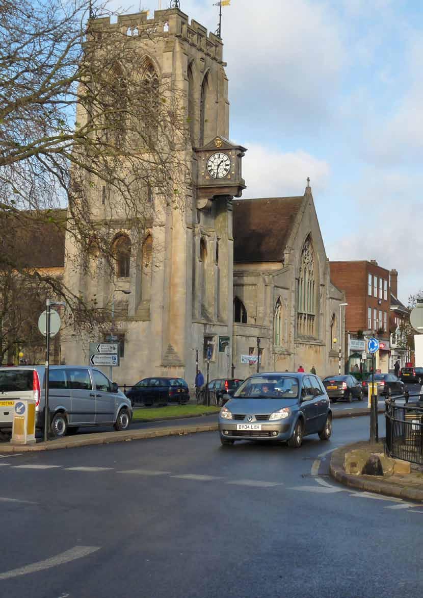
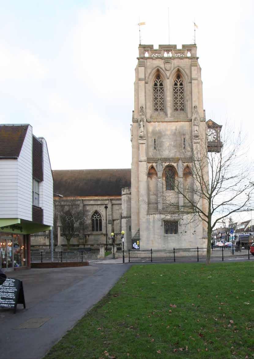
3 contents 1. introduction 5 2. site context 7 3. policy context public consultation development guidelines 25 Allies and Morrison Urban Practitioners Opposite page St John the Baptist Church on the junction of High Street and St John's Road St John's Road Development and Design Brief, Epping Draft report August
4 4
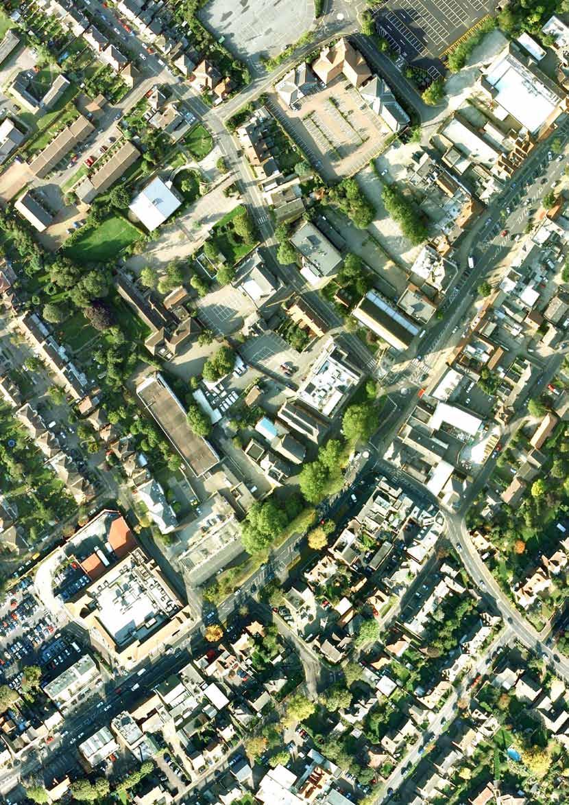
5 1. introduction Introduction The St John's Road Design and Development Brief has been prepared to guide the future shape of the St John's Road area following the relocation of the Junior School to new premises. Along with significant plans being considered for the Parish Church, this presents a major opportunity for the town centre. This development and design brief has been prepared by Allies and Morrison Urban Practitioners on behalf of Epping Forest District Council and Essex County Council. The process of preparing the document has also included commercial property advice and highway design advice along with considerable consultation with key stakeholders and the wider public. Purpose The purpose of this development and design brief is to provide the urban context for the St John s Road area and set guidelines for appropriate development. Once adopted by Epping Forest District Council, the development and design brief will also provide planning guidance for development management purposes. The brief will be taken as a material consideration in the determination of any planning applications for the development of the site. However, national and local planning policy may change and any applications will be determined in accordance with the adopted planning policies at the time a decision on the application is made. Opposite page Aerial photograph showing development brief area St John's Road Development and Design Brief, Epping Draft report August
6 6

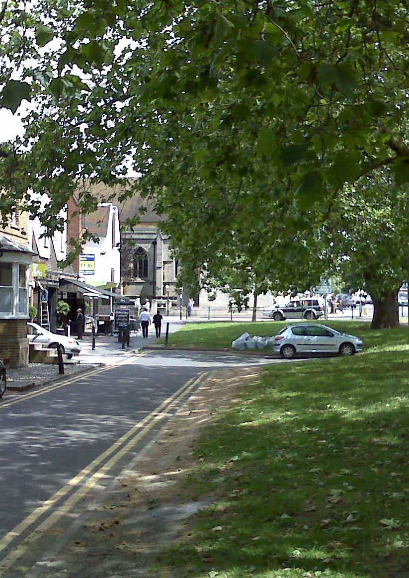
7 2. SITE CONTEXT Location The development brief area is located in Epping Town Centre on the north west side of the High Street. It straddles St John's Road and is bordered by the High Street, the backs of residential properties on Crows Road and Bodley Close and the rear of offices facing Bakers Lane. Epping has an historic town centre with an attractive linear High Street. The core of the shops and services is located to the north/east of the junction of the High Street with St John's Road - the Parish Church and The EFDC council offices essentially act as bookends to the centre. Commercial uses extend south/west of the Parish Church with a more secondary/specialist character and some large breaks in continuity. The development brief area is located close to the existing town centre car parks and is 650m from Epping tube station which provides access to London via the Central Line. St John's Road Conservation Area Site boundary Town centre high street Station Road B1393 Epping underground station Figure 1: Site location plan Opposite page Green area and mature trees on High Street St John's Road Development and Design Brief, Epping Draft report August

8 Key components of the site and land ownership The ownership of the site is split between a number of different public and private bodies. Essex County Council has the largest land holding with the Junior School and the Library sites providing the most significant opportunity for change. Epping Forest District Council and Epping Town Council both have land ownerships adjoining the school site, presenting the opportunity for larger coordinated development. The Parish Church of St John owns both the church site and also the church hall building to the north of the library and is likely to be a key owner in the area given that there are plans for new development associated with the church which may involve land disposal. 0.24ha 0.23ha 0.83ha 0.22ha 0.22ha Ownership plots Essex County Council Epping Forest District Council Epping Town Council St John the Baptist Church Figure 2: Land ownership 8
 Owned by the Town Council, this building is underutilised in its current form and")
 This vacated building and site provides the main development opportunity.")
 Also known locally as the Centrepoint building, this locally listed building is")


9 Epping Hall (0.24ha) Owned by the Town Council, this building is underutilised in its current form and could potentially form part of any redevelopment. Epping Junior School (0.83ha) This vacated building and site provides the main development opportunity. Epping Centre (0.22ha) Also known locally as the Centrepoint building, this locally listed building is currently vacant and can be considered as part of the redevelopment site of the former junior school. Council depot (0.22ha) These existing depot and storage uses could potentially be relocated if required. Library and Registry Office (0.23ha) The existing building has a poor frontage to St John's Road with a significant level change. The garages to the rear of the building are not in use. St John the Baptist The Church is planning to build a new hall on the site of the current vicarage, to be adjoined to the main church building. The existing church hall will likely be sold as part of this process. St John's Road Development and Design Brief, Epping Draft report August

10 Land use There is a high concentration of community uses within the site area as represented by the two churches, Epping Hall, Epping Library and the former Epping Junior School. However, it should now be borne in mind that the junior school was recently closed and the use relocated to new premises. The site is bordered to the north and west by suburban housing, with only very limited elements of housing within the site at present. Retail/services and cafés/restaurants are concentrated along High Street. The town centre presently has two food stores, the Marks & Spencer store in the centre of the High Street and the Tesco to the south west of the core town centre. There is one relatively large office development to the north of the site on the corner of Bakers Lane and Cottis Lane. Other offices and professional services are found in small numbers around the town centre. The existing leisure centre is located away from the town centre on Hemnall Street to the south. Housing Shops and services Bars/cafes/clubs/restaurants Offices Community/health/education Vacant Other Figure 3: Land use 10

11 Heights The building heights in Epping Town Centre are generally two to three storeys high, with the High Street in particular characterised by a variation in scale between plots. A number of the more significant buildings such as the Police Station have a bold scale to them which is substantially larger than some of the more domestic buildings in the town centre. Away from the High Street the areas of housing built during the twentieth century are much more consistent and homogenous in character and are almost exclusively two storey development. 1 storey 2 storeys 3 storeys Figure 4: Building heights 4+ storeys St John's Road Development and Design Brief, Epping Draft report August

12 Built heritage A substantial part of the site falls within the town centre conservation area, and there are a number of buildings which either have statutory listed status, locally listed status or are noted as having townscape merit for their contribution to the wider area. The key listed buildings are the imposing St John the Baptist Church (Grade II*) on the corner of the High Street and St John s Road along with the row of charming weather-boarded cottages on St John s Road (Grade II). The Centre Point building is a former schoolhouse and has a simple, solid charm whilst the former cookery school within the school campus is an attractive and more elaborate small building. Other buildings, including the Methodist Church, fronting the High Street make a significant contribution to the overall character of the area. Further information on the built heritage of the area can be found in the Epping Conservation Area Appraisal Cookery school building 5 2. Epping Centre / Centrepoint 3. Weather-boarded cottages 4. St John the Baptist Church 5. Methodist Church Listed building Locally listed Townscape importance Figure 5: Built heritage 12

13 Trees and green spaces The mature trees and green space on the High Street are a key characteristic of the approach to Epping town centre from the south. The mature plane trees are of a substantial scale and make a significant contribution to the area, signalling the gradual change from an urban high street towards the edge of the town and the countryside beyond. Within the study area there are some small pockets of green space and existing trees. The most substantial trees are along the south western boundary between the school site and the gardens of the houses on Crows Road. Figure 6: Trees and green spaces St John's Road Development and Design Brief, Epping Draft report August

14 Site issues There are a number of key issues relating to the development and design brief area as shown on Figure 7 (below). Commentary on these is provided on the following page, with each point numerically cross referenced to Figure Heritage building 3 Weak townscape building Prominent green space Main former school building BT telephone exchange Gradient across site Town centre frontage Significant levels of vehicular movement Lack of pedestrian connection Figure 7: Site issues 14
15 1. Heritage buildings - The brief area contains a number of key heritage buildings as shown previously on Figure 5. The retention and setting of these should be a key consideration of any development proposals. 2. Weak townscape buildings - These buildings fail to make a positive contribution to the townscape quality of Epping. 3. Green space on High Street - This green space and the mature trees within it form a key part of Epping's leafy character. However, it has potential to be more fully utilised as a public space for the town. 4. High Street frontage - The brief area includes some of Epping's core high street, meaning that there may be potential to expand the town's retail capacity with new development that has strong connections to existing shops. 5. BT exchange - The BT exchange is largely hidden from sight from the road. Whilst it is likely that this would be expensive to relocate, there may be potential to reduce the footprint of the existing building to create opportunity for new development. 10. Epping hall - Epping Hall is owned and operated by Epping Town Council. Whilst this is a relatively modern building, it is unusual in its configuration and not well suited to the needs of the local community. 11. Library - The library is owned and operated by Essex County Council and is also the location of the local Registry Office. Essex County Council is investigating ways to increase its role as a community hub, including utilising existing office space within the building which is currently vacant. The garages to the rear of the library are not in use. 12. Lack of pedestrian connection - The lack of buildings along this route offers opportunity to form a more direct connection to the Bakers Lane car park. 13. Vehicular movement - The High Street is heavily trafficked and the junctions with St John's Road and Station Road are particular locations for traffic congestion. 14. Gradient across site - There is significant change in level across the site, with the land sloping down away from St John's Road. 6. Main former school building - The former school building has limited heritage value and presents the major redevelopment opportunity. 7. Former cookery school building - This freestanding building is attractive and should be retained. 8. Centre Point - This attractive building has a strong presence on St John's Road and should be retained. 9. Existing church hall - The church hall is in a poor quality building which the parish church intend to replace with a new hall built as an extension to the main St John's Church building. St John's Road Development and Design Brief, Epping Draft report August
16 16

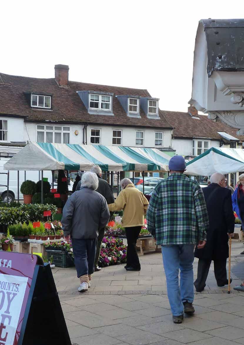
17 3. policy CONTEXT National Planning Policy Framework The national planning context is provided by the National Planning Policy Framework (NPPF) which was published in March The NPPF condensed the previous Planning Policy Statements and Planning Policy Guidance Notes into one document, with the intention of making the planning system less complex and more accessible. The NPPF sets out the Government's planning policies for England and how these are expected to be applied. It provides a framework for Local Authorities to produce their own distinctive local plans which reflect the needs of the their communities. The NPPF is published by the Department for Communities and Local Government and is available from: planningandbuilding/nppf Epping Forest District Council Local Policy Epping Forest District Council is currently updating its planning documents to create a new Local Plan as required by the NPPF. Planning policy for the local authority is currently provided by the Combined Polices of Epping Forest District Local Plan (1998) and Alterations (2006), available from: planning/forward_planning/local_plan_obtaining.asp The development brief area is also within Epping Conservation Area. Any development proposals will need to respect the character of the Conservation Area, with guidance provided by the Epping Conservation Area Character Appraisal and Management Plan, available from: planning/conservation/conservation_areas.asp National Planning Policy Framework Epping Conservation Area Character Appraisal and Management Plan November community, opportunity, prosperity National Planning Policy Framework Epping Conservation Area Character Appraisal and Management Plan Opposite page Epping's popular Monday market on High Street St John's Road Development and Design Brief, Epping Draft report August


18 4. public consultation Public and stakeholder consultation Consultation on the preparation of this brief commenced in early 2009 with stakeholder meetings and a stakeholder consultation event. Following the development of potential options for the site in consultation with key groups such as the Town Council and the Parish Church a major consultation process was undertaken. A summary of the key consultation outcomes is presented here. A detailed set of comments and data for the consultation is presented as a separate appendix. Public exhibition A public exhibition was held in March and April For the first month it was held in St John's Parish Church and for the second month it was held in Epping Library whilst a duplicate exhibition was displayed throughout the period in the Epping Forest District Council offices. The exhibition outlined the main issues facing the development brief area and included four options for how change could be realised. These options and the text from the exhibition are displayed on the facing page. The exhibition was supported by a questionnaire. This was also available on-line with an electronic version of the exhibition available for download. A total of 826 responses were received, of which 462 were submitted as paper questionnaires or letters and 354 were submitted on-line through the council website. Opening of the exhibition in St John the Baptist Church 18

19 1 // Retail-led option 2 // Leisure-led option 3 // Retail & leisure option 4 // Residential option A comprehensive approach to the site which could deliver significant new retail development including a food store. It also has the potential to integrate well with the High Street and to improve existing community facilities such as the library. An option which would deliver new leisure facilities to replace those on Hemnall Street as well as delivering a substantial area of new housing and some improvements to the community facilities and pedestrian network. A composite approach which includes the potential for a new food store but also includes a new leisure centre. It includes the same proposals to create new links and public space around the parish church and to improve the library as option 1. An approach which would be focused on delivering residential development with minimal retail/community facilities. This could be delivered as phases of development, allowing for the Epping Hall to remain in situ if desired New supermarket New shops New housing New telephone exchange New/retained community use New offices Key features The material contained in this plot has been reproduced from an Ordnance Survey map with the permission of the Controller of Her Majesty s Stationery. (c) Crown Copyright. Unauthorised reproduction infringes Crown Copyright and may lead to prosecution or civil proceedings. EFDC licence No Food store, with enclosed service yard to the north and decked parking at-grade with the store and below, taking advantage of the slope of the site 2. Retained former cookery school building providing opportunity for either commercial or community use, possibly as a new space for the Town Council 3. Centre Point building refurbished and opened up to create new arcade 4. Larger format retail with housing above 5. New high quality housing 6. Potential for future redevelopment of the telephone exchange site featuring new housing 7. New vehicle access from the High Street 8. New library building with commercial uses on the ground floor 9. Potential for future new office development 10. New link from the Baker s Lane car park, possibly including an element of parking 11. Potential for further new development, either commercial office space or residential 12. New commercial development suitable for cafes or boutique shopping and with residential development above fronting onto a new lane around the church 13. New church amenity building New leisure centre New shops New housing New telephone exchange New/retained community use Key features The material contained in this plot has been reproduced from an Ordnance Survey map with the permission of the Controller of Her Majesty s Stationery. (c) Crown Copyright. Unauthorised reproduction infringes Crown Copyright and may lead to prosecution or civil proceedings. EFDC licence No New sports and leisure centre based around a refurbishment of the existing Epping Hall 2. Retained former cookery school building providing opportunity for either commercial or community use, possibly as a new space for the Town Council 3. Centre Point building refurbished and retained for community use 4. New high quality housing 5. Potential for future redevelopment of the telephone exchange site featuring new housing 6. New minor vehicle access from the High Street 7. Existing library building remodelled to create an entrance on the southeastern side where it can be visible from the High Street 8. New commercial development suitable for cafes or boutique shopping and with residential development above fronting onto a new lane around the church 9. New church amenity building New supermarket New leisure centre New shops New housing New telephone exchange New/retained community use New offices Key features The material contained in this plot has been reproduced from an Ordnance Survey map with the permission of the Controller of Her Majesty s Stationery. (c) Crown Copyright. Unauthorised reproduction infringes Crown Copyright and may lead to prosecution or civil proceedings. EFDC licence No Food store, with enclosed service yard to the north and decked parking at grade with the store and below, taking advantage of the slope of the site 2. Retained former cookery school building providing opportunity for either commercial or community use, possibly as a new space for the Town Council 3. Centre Point building refurbished and opened up to create new arcade 4. New sports and leisure building with frontage onto the new square 5. Potential for future redevelopment of the telephone exchange site featuring new housing 6. New building creating frontage onto the High Street 7. New vehicle access from the High Street 8. New library building with commercial uses on the ground floor 9. Potential for future new office development 10. New link from the Baker s Lane car park, possibly including an element of parking 11. Potential for further new development, either commercial office space or residential 12. New commercial development suitable for cafes or boutique shopping and with residential development above fronting onto a new lane around the church 13. New church amenity building New housing New/retained community use Key features The material contained in this plot has been reproduced from an Ordnance Survey map with the permission of the Controller of Her Majesty s Stationery. (c) Crown Copyright. Unauthorised reproduction infringes Crown Copyright and may lead to prosecution or civil proceedings. EFDC licence No New high quality housing 2. Potential for a central space 3. Retention of the Centre Point building for community use 4. Establishment of a new pedestrian link into the site as a continuation of the existing lane Our evaluation of this option: Our evaluation of this option: Our evaluation of this option: Our evaluation of this option: We think this is a really strong option which could enhance the town centre retail offer and could help to improve facilities such as the library. It would create a good mix of uses as well as attractive new routes and spaces which would improve the setting of the church. This option is financially viable. This option would provide new leisure facilities and bring some improvements to other community facilities. However, it would not add significantly to retail capacity of the town centre and the leisure centre element of the project would require the District Council to contribute several million pounds to the project, making the option unviable. Option three represents the most comprehensive package for the town centre in terms of activity and mix of use. However, the leisure centre element of the project would require the District Council to contribute several million pounds to the project, making this option unviable. This option is financially viable. It is mainly high-quality new housing, and, although it is not expected to contribute significantly to the strength and vitality of the town centre, its impact on traffic is likely to be minimal. The site can be designed to respect the local historic character but it would not include the improvements around the Parish Church or the library. It would be expected to provide some limited community facilities. Display panel from the St John's Road Design and Development Brief exhibition St John's Road Development and Design Brief, Epping Draft report August
20 Questionnaire responses Question 1 The first question asked respondents whether they agreed with the core project principles which had been set out in the consultation material as follows: The development needs to be strongly integrated with the High Street and the rest of the town centre; The area should include a sustainable mix of uses and create high quality public streets and spaces; Any development should respect and complement the historic character and scale of the town centre with buildings of the highest quality; and The ideas for development should make the most of this once-in-a-generation opportunity for the town but should be practical, deliverable and affordable. The responses provide a very strong positive feedback on this question, with 477 people either supporting or strongly supporting the principles whilst 178 people disagreed or strongly disagreed with the principles. 91 people indicated a neutral response and a further 80 people did not complete the question. It is instructive to read the written comments which accompany the scores. These indicate that people have tended to rate the illustrative schemes in the exhibition rather than the core principles as the questionnaire asked. Many of the comments mention issues which do not relate to the principles given and so people may not have answered the question accurately. Question 2 Question two asked people to tick five things from a long list to identify what they would consider the best for Epping town centre. The graph on the facing page shows how people responded to the question. The most common responses were: Provision of improved sport and leisure facilities in the town centre was the stand-out issue with 535 of all respondents ticking this option; Protection of historic buildings and respect for historic scale were the next two most selected issues with 401 and 382 votes respectively; Provision of space for adult education received a high response of 315 votes; Protecting existing trees and new high quality public space were the next two most selected issues with 256 and 225 votes respectively; Smaller shops / boutiques received 203 votes; and New or improved library received 185 votes. Question 3 Question three provided people with space to make their own comments on the plans. Two key themes received by far the largest percentage of responses, these were the opposition to a new supermarket and the desire for a new or improved leisure centre. 26% of respondents stated their opposition to a new supermarket as part of question three, with traffic concerns and impact on the existing high street often included alongside. This was balanced by 3% of respondents stating that a new supermarket is needed, with Waitrose specifically mentioned. 20

21 Improved sports and leisure facilities Protection of historic buildings Respecting the historic scale of the area Space for adult education and training Protecting existing trees New high quality public space Smaller shops/boutiques New or improved library building New premises for the Citizens Advice Bureau Community buildings for hire New affordable housing New facilities for the Parish Church More town centre parking New houses Space for start-up businesses Larger non-food shops Town centre supermarket Cafes/restaurants New flats Better Pedestrian links to car parks New premises for the Town Council New office space Graph showing responses to the question 2 tick boxes St John's Road Development and Design Brief, Epping Draft report August
22 Youth workshop 15% of respondents stated that a new or improved leisure centre was needed, with 8% making specific reference to a swimming pool. Other responses which were received multiple times, but with less regularity than those above, include: That Centre Point should be converted into a community use and kept as a public building; That more community based facilities are needed, particularly youth orientated ones; The impact of any new development on traffic levels; That the character of Epping as a small historic market town should be protected; and That Epping already has enough cafés and restaurants. In addition to the exhibition a youth workshop was held in The Box on Epping High Street. This was held over two hours during the time that many young people use the facility after the school day. Young people were asked what they would like to see on the Development Brief site. Responses include: A football pitch with astroturf and the facilities required for a football academy; A bigger and better skate park; National restaurant chains (McDonalds, Burger King and KFC); National high street retail outlets (JD Sports, HMV, Vans, Primark, etc.); A larger youth centre; A college; Housing; A swimming pool; and A bowling alley/cinema. 22
23 Conclusions The public consultation identified a number of key themes: There are significant concerns about the provision of a new food store on the site, including concerns about scale and bulk, parking, traffic impact and impact on the High Street. Conversely, there would be a greater level of support for small shops or a department store. There is strong support for improved sport and leisure provision in the town centre, potentially as a replacement for the Hemnall Street leisure centre. Other leisure uses which have been suggested include a cinema. There is strong support for an approach which protects the historic character and scale of the area and which retains the green space and mature trees on the High Street. There is a desire expressed for improved community facilities in the town centre and particularly for the inclusion of facilities for adult education and an improved/redeveloped library. The proposals accommodate and facilitate the proposed developments being planned by the Parish Church; Clear guidance is given on the acceptable scale and massing of any new development, with particular reference to the historic character of the town centre; and The potential for housing development is noted, although it is clear that this should not be the predominant ground floor use on key frontages given the town centre location. In response to this and the rest of the consultation responses the brief takes the following approach: There is provision for leisure uses to form a key part of any development proposals, both in terms of sports and leisure use and also in terms of commercial leisure such as a cinema; The policies note that retail uses could be included on the basis that they are well connected with the High Street and form a complementary rather than competing offer; The potential for community uses including adult education is noted, and potential options identified for the library building to either be redeveloped or remodelled to enhance links with the town centre; St John's Road Development and Design Brief, Epping Draft report August
24 24
25 5. development guidelines Development objectives The St John s Road site represents the best current opportunity to accommodate growth in Epping town centre and would provide the first site of any notable scale for a generation. Opportunities such as this are needed if Epping is to maintain its place in the hierarchy of centres in the area and continue to support its local population. It is therefore important that any development proposals make the most of this opportunity and that a cohesive plan is developed for the site. The key objectives for the site are as follows: The development needs to be strongly integrated with the High Street and the rest of the town centre; The area should include a sustainable mix of uses and create high quality public streets and spaces; Any development should respect and complement the historic character and scale of the town centre with buildings of the highest quality; and The ideas for development should make the most of this once-in-a-generation opportunity for the town but should be practical, deliverable and affordable. Integration with the High Street Any development on this site will change the High Street and Epping Town Centre in some way. The aim of this design and development brief is to promote an approach to development which will complement the High Street, increase footfall in the town centre and improve the overall vitality and economic resilience of the town centre. To maximise the benefit of any change it is vital that a clear and attractive links are made between new development and the core town centre with a range of active uses. Strong connections will help to promote linked trips between any anchor use and the town centre and will also help to sustain a range of smaller units which respond to the character of Epping. Sustainable mix of uses This site represents a unique opportunity to broaden the appeal of Epping High Street, meeting the need for a wider range of uses which could include community and civic functions, leisure uses, retail, other workspace and housing. A broad mix is necessary to establish an area which will feel like a vibrant part of the town centre both during the day but also into the evening. It may also present the opportunity to provide some larger retail units which would better suit modern retail requirements and so broaden the offer within the town centre, supporting existing retailers. Opposite page St John the Baptist Church on the junction of High Street and St John's Road St John's Road Development and Design Brief, Epping Draft report August


26 High quality public realm Development in this site provides the opportunity to create new areas of public realm which include pedestrian spaces away from busy roads. This establishes a framework which will allow civic, community and commercial uses to spill out into public space in a way which is not possible in the High Street due to the dominance of cars. Historic scale and character Epping High Street is characterised by substantial two and three storey buildings whilst further away from the High Street the residential scale is predominantly two storey. This site area falls on the transition point between the town centre and the residential hinterland and so any development must mediate between the scales in a sensitive manner. Also of significance is the nature of the existing town centre development, which is broken into narrow plots with significant variation in scale, materials and detailing between buildings to give a pleasingly jumbled character rich in detail. Development on the site will be expected to reflect this historic character without resorting to pastiche design. Deliverable development The proposed development must be deliverable. However, as the core of the site area is owned by a combination of public sector bodies, it is also important that any development delivers best value for the wider town. In some cases this could take the form of a capital receipt whilst in other cases it could relate to using the assets to deliver community benefits. Cars parked on High Street Green space on Epping High Street Epping library 26
27 CONSERVATION The site area is located partly within the town centre conservation area and provides the setting for some significant listed buildings. It is therefore important that every effort is made to protect and enhance the existing character of the town centre, whilst also seeking to make improvements where possible. Response to the existing buildings: St John s Parish Church The Grade II* listed parish church is a strong building and one of Epping s major landmarks. As such it would be inappropriate for any new buildings in the vicinity to challenge it in terms of scale or massing. The development framework establishes the potential for a new route to the north of the church. This would remove the existing single storey shop (existing carpet shop) fronting the High Street and the garages behind to improve the setting of the building. The parish is also seeking to replace the 1960s church house to the north west of the church with a more appropriate building which would provide much needed ancillary spaces for the church. This relates well to the principle of the new public realm which this document proposes and will help to further integrate the church with the surrounding town St John s Road This terrace of charming weather-boarded cottages is Grade II listed and forms one of the defining aspects of the southern part of St John s Road. It is important in this context as it sets a very domestic scale and provides a counterpoint to the muscularity of the church building. Former cookery school building Whilst the bulk of the school buildings are not considered suitable for adaptation or re-use, the former cookery school building could be an interesting exception. It is a relatively small standalone structure which could be retained as part of a scheme, perhaps framed as the centre-piece of a new public space in the manner of a traditional market building. High Street grouping A number of buildings on the High Street including the former council office and the Methodist church play a role in defining the character of the area. Whilst the buildings themselves may not be sufficiently distinguished to warrant listing, the conservation area appraisal identifies them as having an attractive group value which is worth protecting. Centre Point building The former school building known as the Centre Point building has a strong presence, partly due to its striking double gable form, but also due to its position on the bend in St John s Road which ensures that it is visible from the High Street. As with the rest of the school campus this building is surplus to educational requirements. However, public consultation has highlighted that this building should ideally remain in public use. The building is locally listed and is also protected by conservation area designation. St John's Road Development and Design Brief, Epping Draft report August
28 PUBLIC REALM A project on this site has the potential to deliver new elements of public realm which both evoke the history of the town centre, but also establish new links to open up the town to further development opportunities. A new public space can be created at the heart of the main site to the south/west of St John s Road. This could act as the focal point for public, commercial or leisure uses and could be designed to create a new pedestrian-only space. A new link route is proposed which connects the heart of the development area with the High Street. This would be created through the removal of the existing carpet shop fronting the High Street and the redevelopment/remodelling of the library. This new lane would reflect the historic urban character of the High Street which has a series of similar small lanes leading to secondary areas away from the main street. A new space created to the north/west of the church would provide a small square with the library, church and commercial uses fronting onto it. This space would also deliver strong visual linkage across St John s Road to the main body of the site. This could achieve a vibrant and exciting town centre space which could play a number of roles. against the road which appears to be used by a smaller number of people. Changes to the junctions and the inclusion of a new access way may require the removal of the footpath which runs against the road. This project presents an opportunity to improve the shared surface route which passes in front of the buildings. Particular consideration should be given to the surface used and to the provision of street lighting which makes the area safer for pedestrians in the evening. Public spaces and streets which are created through any development should be clearly defined by buildings with active frontages. The character of the town centre, most strikingly demonstrated along the High Street is for buildings to follow a consistent building line, regardless of height and detailed design. New development should expect to follow a similar terrace pattern, establishing a strong street frontage, regardless of the use in the building. The predominant character of the area is expected to be urban, reflecting the town centre location and the potential for town centre land uses. However, opportunities to introduce areas of softer streetscape such as a pocket park and/or play area would be welcomed. The green space along the High Street is an important part of the character of the town centre and should be protected. The line of mature plan trees is particularly impressive and forms an important part of the character of this area. At present, there are two pedestrian routes running parallel to one another. Firstly, there is the main shared surface lane which runs close to the buildings and appears to be widely used by most people walking through the area. The second is the footpath 28
29 LAND USE The area covered by this brief is located within Epping s town centre boundary. This is one of the three principal town centres in the District, and as such is regarded as a suitable location for a range of uses. Epping Forest District Council s policies on town centres support the provision of uses that make the centres attractive and useful places to shop, work and visit throughout the day and evening. Whilst residential development might be included in this area, it is not expected to be the predominant ground floor use. The following potential uses may feature as part of an overall mix of uses in any proposals: Leisure This site provides an opportunity to accommodate a range of leisure facilities. This could include new sport and leisure facilities such as a replacement to the Hemnall Street site or a commercial leisure use such as a cinema. Careful consideration should be given to the scale and massing of any new leisure facility given the historic urban context. It will also be important to consider the external form of the building and particularly to ensure that it does not compromise the need to maintain active ground floor frontages in more significant streets and spaces. Retail Retail development could form part of a mix of uses within the site, provided that a clear and direct sense of connection with the High Street can be established. Any retail development should aim to complement rather than compete with the High Street to support the overall vitality of the town centre. Any larger format retail will be expected to present an active shop front to key routes to establish an attractive town centre character. Food and drink There is some opportunity to provide new restaurants and cafes as part of a mixed scheme. However, this should be considered within the context that Epping is already well served with food and drink establishments and so any new proposals should be limited to key locations which are able to take advantage of new public spaces. Community This site already contains a range of public and community uses including the library and two churches. It is envisaged that this kind of use will continue to form an important aspect of the site s character and that development could support the delivery of some new or improved community facilities. This could include facilitating the planned development at the parish church, improving or replacing the library and delivering new public uses in the Centre Point former school building. The provision of suitable space for Adult Education in the town centre was identified through the consultation process and should be explored as part of any proposals, potentially as a use for the Centre Point building. Employment New employment uses would relate well to the requirement to deliver a mix of uses in a town centre location. There is an expectation that employment use could be suitable for upper floor uses. However, in locations away from the principal frontages it may also be suitable for ground floor use. Residential New housing should be included in development plans as part of a mix of uses. To be in conformity with the District s current planning policy, this should generally be at upper levels. However, recognising that the depth of the site may limit commercial St John's Road Development and Design Brief, Epping Draft report August
30 HEIGHT, SCALE AND MASSING potential there may be scope for some elements of town house development in locations away from the High Street or St John s Road. Hotel A hotel use may be considered suitable for a town centre location, particularly as part of an overall mixed use scheme and could prove beneficial in maintaining a more vibrant character into the evening. There is potential for links with any leisure facilities and for overlap with any restaurants or cafes proposed but care would need to be taken to ensure that the scale and massing of the building and the likely servicing and parking do not have a significant negative impact on the area. The scale of development within the planning brief area should reflect the prevailing low rise character of the surrounding context. As has been previously noted this area forms the transition between the town centre which features a mix of substantial two and three storey buildings and the residential hinterland which is formed of more domestic two storey buildings. Other factors which should be considered in the scale of new development include the setting of the existing listed buildings on St John s Road and particularly the need to provide a sensitive setting for St John s Parish Church. The central area of Epping is characterised by buildings of a range of ages and styles. Whilst the buildings along the High Street adhere to a common building line they vary considerably in height. The overall effect is a pleasing mixture which has a strong rhythm formed by the individual plots. It is important that any new development in this area is designed to create a character which reflects this variation and fragmentation. Whilst this will work in a straightforward way for smaller scale uses such as residential development or small shops it will be important that any proposals for larger buildings also demonstrate how they respond to this character without resorting to pastiche. New buildings should respect the amenity of neighbouring residential properties in terms of light, privacy and outlook. This is particularly significant for the buildings on Crows Road and Bodley Close which back onto the site area and may experience a change in context with new development. It should be demonstrated that any development proposals would not have a significant detrimental impact to the amenity of any neighbouring properties. 30 Opposite page Former cookery school building within vacated Epping Primary School
31 SUSTAINABILITY Any new development will be expected to at least meet the national and local planning policy with regard to sustainable design and construction. However, as a town centre site there will be opportunities for more broad sustainability themes to be explored which can benefit the wider area. Development which supports the health and vitality of the town centre and focuses appropriate uses in the centre of Epping will help to reduce trips made to other centres and will assist in resisting development on inappropriate out of town sites. Similarly, centrally located shops, leisure uses and community uses will help to maximise use of sustainable modes of transport. Considering the design of buildings to include provision of shading to reduce internal solar gain and also to use pale roof surfaces to limit heat absorption; and Using tree planting to provide a significant element of shade to public spaces at peak times in the summer to reduce heat absorption into the paving and buildings. Walking and cycling should be given priority within the design of streets and spaces. This will particularly relate to elements such as the links to the High Street and the provision of good quality cycle parking in visible locations. A development of this scale is likely to provide the critical mass needed to make the provision of a Combined Heat and Power (CHP) possible, particularly if there is a large building such as a leisure centre which has a significant continuous requirement for heat and power. Buildings and spaces should also be designed with a view to limiting the impact of any global climate change. This can take a number of forms, including: Using SUDS (sustainable urban drainage systems) to reduce the impact of rapid water run-off from the paved areas and help to reduce flash flooding. This could include measures such as providing houses with water butts to store rain water, green roofs on buildings, water permeable hard surfaces and maximising the amount of land given to vegetation; St John's Road Development and Design Brief, Epping Draft report August
32 PLANTING AND LANDSCAPING Trees play an important role in the character of Epping, both in terms of its wider setting, but also in the character of the immediate area with the row of mature plane trees along the High Street. This makes a significant contribution to the character of the area and should be given due consideration and protection. Public spaces within any new development should be used as opportunities to establish new tree planting which reinforces the character of the area. As well as the benefits to the character and quality of the space this would bring, appropriate deciduous tree planting will also help by providing shade at warmer times of the year to mitigate against the impact of climate change to the reduce heat absorption in the urban area. Where new homes are considered, the inclusion of private gardens creates opportunities for further planting, both to the rear of properties but also to the front where it can add to the streetscape. Planting may also be considered for any larger areas of roofscape, using green roofs to enhance biodiversity, attenuate rainwater run-off and reduce the heat-sink effect of a large building. ACCESS There are two principle vehicular access opportunities into the larger site area to the west of St John's Road. These are from St John's Road itself, or from High Street through land currently used as the council depot. The access from the High Street would involve the creation of a new junction. Initial testing work undertaken to support this study suggests that this will be possible, but that care will be required to ensure that the junction and the visibility splays do not affect the existing mature trees. A new junction in this location and improvements to the other two mini roundabouts could be eased by the removal of the footpath against the road which is duplicated by the more popular shared surface way at the back edge of the green space. An access from St John s Road could be created within the space from the centre point building to the northern corner of the site and would most probably take the form of a T-junction. The access from the High Street has a number of advantages over the St John s Road access. Firstly, computer modelling demonstrates that it limits the additional traffic load on St John s Road, helping to maintain the quality of environment for pedestrians. Secondly, it delivers vehicles to the lower part of the site, away from the more visible frontages, into locations where parking could be most suitably accommodated. The natural downward slope of the ground away from St John s Road suggests that some element of decked parking might also be incorporated. The access from St John s Road would retain a useful role in providing service access to any commercial uses. 32
33 PARKING Pedestrian access to the site from the town centre is currently along St John s Road. Although this has a number of public and community uses along it, the distinct change in character from the High Street makes it feel remote from the rest of the town centre and there is a risk that any development is seen in isolation. Given that this site presents a major opportunity to deliver new growth for the town centre, a strong link is an important aspect of the approach. There is an opportunity to achieve this through the removal of the existing single storey shop unit to the north of the church on the High Street to open up access to the land behind the church to create a new route. This pedestrian connection has the potential to establish a mix of new small units with active street frontage and create a new clear connection between the library, either in a remodelled form or in a new building. Good practice guidelines for parking design and quantum are provided in the Essex County Council's 2009 document - Parking Standards. In applying the Essex-wide parking guidelines, consideration will be taken of the central location of the development and design brief area within Epping. The area is relatively well served by public transport and lower levels of parking could be accepted than would be the case in less central locations. It is expected that the level of car parking provided within any proposals will need to be rigorously justified as part of any planning application. Parking for residential development The parking requirement for any residential development will be considered on the basis that each dwelling will require at least one allocated space. More parking may be considered appropriate for larger dwellings, but there should not be an expectation that parking is required at suburban levels given the easy access to shops, services and public transport. Parking for leisure and retail uses Small scale leisure or retail facilities such as small individual shops would not be expected to provide new customer parking. However, any development which features a significant quantum of public uses would be expected to provide parking. Whilst this parking provision may be owned and managed privately, it would be expected to contribute to the overall provision of parking in the town centre. St John's Road Development and Design Brief, Epping Draft report August
34 KEY SITES - LAND OWNERSHIP AND PHASING The land ownership across the area covered by the brief is split between several owners. Whilst elements of the site can successfully be developed on a stand-alone basis, it is important that the relationship between the sites is understood and that a cohesive vision exists to coordinate any development. The implications for the individual sites can be summarised as follows: Main school site, owned by Essex County Council The main school site would be capable of development as a stand-alone site. However, the presence of the Centre Point building on St John s Road and the lack of any alternative access would make it difficult to realise a scheme which could be said to deliver a significant town centre development without being integrated with surrounding sites. The Centre Point building and the former cookery school building are two elements which should be considered for retention. Epping Hall site, owned by Epping Town Council The Epping Hall site would be difficult to redevelop successfully in isolation as the terraced land form created for the current development makes the back part of the site difficult to access from the road. It could be successfully developed as part of a joint scheme with the former school site and might be necessary if any large development was to be considered. Depot site, owned by Epping Forest District Council The depot site offers limited development potential as a stand-alone site, but would be important to any major scheme planned on the school site as it would provide a better access way for vehicles. Telecoms exchange building, owned by Telereal The existing telephone exchange is buried in the heart of the block and is not visible from the street. The site offers the potential for redevelopment in the event that a new road is delivered through the depot site. This would offer the potential for a new, smaller exchange building with a terrace of development fronting the road. This scheme could be delivered as a stand-alone project following the implementation of the new road. Epping Library, owned by Essex County Council The Epping library building also contains a number of other public uses including the registrar s office. Potential exists to either remodel or redevelop this building as part of the project to establish a new pedestrian link to the north of the parish church. The process to redevelop the building would be closely tied to the future of the old church hall building to the north/west. Church hall building, owned by the Parish Church The old church hall building to the north/west of the Library was originally built as a temporary structure to provide church premises whilst the main church was being constructed. The Parish has expressed a desire to sell this site for redevelopment to raise capital for the construction of a new facilities building attached to the church itself. The site of this building would be required to deliver any option which considered major redevelopment of the library to establish new open space. In the event that the decision is taken not to redevelop the library site in this way the church-owned land would be suitable for a small residential development. 34
35 Former church house site, owned by the Parish Church The site of the 1960s church house adjacent to the church has been identified as an opportunity to develop a new extension to the church building itself. This would provide meeting rooms, kitchen space and toilets which would enable the church to be used much more flexibly, supporting its use for worship, but also opening it up to a wider range of community uses. This project could be delivered as a stand-alone project, provided that the design takes due consideration of the existing and future context. As noted above, the sale of the old church hall site to deliver this development project is closely linked to the potential development of the library site. Existing carpet shop, Epping High Street The existing carpet shop facing onto the High Street is a small infill development between the larger neighbouring building and the church and does not feature on historic plans of the area. The site of the building has been identified as a suitable opportunity to create a link from the High Street to the Library and then on to the main body of the site across St John s Road. This would both create a new link but also go some way to improve the setting of the church. The new route would entail the removal of the carpet shop and the development of the area of car parking which currently sits behind the church and library to establish new frontage. A further link from this lane could also be created towards Cottis Lane and the main town centre car park. St John's Road Development and Design Brief, Epping Draft report August
36 36

37 St John's Road Development and Design Brief, Epping Draft report August
GREENFORD HALL & ADJOINING LAND
 GREENFORD HALL & ADJOINING LAND CONTENTS 1. Introduction 1. Introduction 2. Urban Context 2.1 The Site and Surroundings 2.2 Urban Context Map 2.3 Access and Movement 3. Planning Context 3.1 Planning History
YMCA Erdington (Phase 2), 300 Reservoir Road, Erdington, Birmingham, B23 6DB
, 300 Reservoir Road, Erdington, Birmingham, B23 6DB") Committee Date: 13/06/2013 Application Number: 2013/03011/PA Accepted: 30/04/2013 Application Type: Full Planning Target Date: 30/07/2013 Ward: Stockland Green YMCA Erdington (Phase 2), 300 Reservoir Road,
Committee Date: 13/06/2013 Application Number: 2013/03011/PA Accepted: 30/04/2013 Application Type: Full Planning Target Date: 30/07/2013 Ward: Stockland Green YMCA Erdington (Phase 2), 300 Reservoir Road,
Former North Works, Lickey Road, Longbridge, Birmingham
 Committee Date: 14/11/2013 Application Number: 2013/06431/PA Accepted: 27/08/2013 Application Type: Full Planning Target Date: 26/11/2013 Ward: Longbridge Former North Works, Lickey Road, Longbridge, Birmingham
Page 1 of 19 URBAN DESIGN FRAMEWORK FOR BOLTON STREET WATERFORD
 Page 1 of 19 URBAN DESIGN FRAMEWORK FOR BOLTON STREET WATERFORD 1.0 Introduction: The relocation of the City Council stores and depot from Bolton Street creates an exciting opportunity for development
16. Peckham Peckham Area Vision
 16. 16.1. Area Vision 16.1.1. is: A lively town centre providing a range of daytime and night time activities on Rye Lane including a Library, a Leisure Centre and many independent retailers which specialise
Land Adj. 63 Sunny Bank Road, Sutton Coldfield, Birmingham, B73 5RJ
 Committee Date: 11/07/2013 Application Number: 2013/03520/PA Accepted: 20/05/2013 Application Type: Full Planning Target Date: 15/07/2013 Ward: Sutton Vesey Land Adj. 63 Sunny Bank Road, Sutton Coldfield,
Colchester Northern Gateway Master Plan Vision Review Draft. July 2016
 Colchester Northern Gateway Master Plan Vision Review Draft July 2016 Contents Introduction 4 Context 8 Purpose of the Report 8 Strategic Position 9 Overview of the Process 11 2012 Master Plan Vision 12
Perth and Kinross Council Development Management Committee 20 February 2013 Report of Handling by Development Quality Manager
 Perth and Kinross Council Development Management Committee 20 February 2013 Report of Handling by Development Quality Manager 4(4)(iii) 13/81 Erection of sports hall, associated changing facilities, offices
Land at Cardigan Street / Belmont Row / Gopsal Street, Eastside, Birmingham, B4 7RJ
 Committee Date: 02/10/2014 Application Number: 2014/05637/PA Accepted: 07/08/2014 Application Type: Full Planning Target Date: 02/10/2014 Ward: Nechells Land at Cardigan Street / Belmont Row / Gopsal Street,
Land at Rampton Road. Cottenham
 Land at Rampton Road Cottenham Introduction TEP is preparing an outline planning application for 54 dwellings on 6.9 hectares of land adjacent to Rampton Road, Cottenham on behalf of the owners Cambridgeshire
Peckham Peckham Area Vision Map
 Area Vision Map PNAAP13 PNAAP8 Sumner Road Surrey Canal Walk Bird in Bush Park Key: NSP Site Allocations PNAAP Allocations Greenspace Low Line Cycle Network Primary Shopping Areas Square Surrey Canal Walk
BLETCHLEY PARK AREA - DEVELOPMENT FRAMEWORK
 ANNEX A To Item 9 REVISED TEXT: additions shown bold and underlined, deletions in (brackets and in italics). BLETCHLEY PARK AREA - DEVELOPMENT FRAMEWORK This framework sets out the key objectives and requirements
Chapter 5 Urban Design and Public Realm
 5.1 Introduction Public realm is all areas of the urban fabric to which the public have access. It is where physical interaction takes place between people. It therefore, includes buildings and their design,
Schedule of Planning Applications Committee Date: 23 May Reference: 06/17/0726/F Parish: Hemsby Officer: Mr J Beck Expiry Date:
 Schedule of Planning Applications Committee Date: 23 May 2018 Reference: 06/17/0726/F Parish: Hemsby Officer: Mr J Beck Expiry Date: 22-05-2018 Applicant: Proposal: Site: Mr Gillett Change of use to the
Paignton Neighbourhood Plan (Submission version 2017)
") Paignton Neighbourhood Plan (Submission version 2017) Introduction This brief statement covers the views of the TDA, only in relation to its role as adviser to the Council on delivery of town centre regeneration.
Paignton Neighbourhood Plan (Submission version 2017) Introduction This brief statement covers the views of the TDA, only in relation to its role as adviser to the Council on delivery of town centre regeneration.
NORTH CIRCULAR ROAD - REGENERATION IN ACTION
 NORTH CIRCULAR ROAD - REGENERATION IN ACTION Notting Hill Housing is a social enterprise which has been at the forefront of vibrant urban regeneration since 1963. Notting Hill has over 25,000 homes across
DEVELOPMENT MANAGEMENT REPORT
 ITEM A08-1 DEVELOPMENT MANAGEMENT REPORT TO: BY: DATE: DEVELOPMENT: SITE: WARD: APPLICATION: APPLICANT: Development Management Committee Development Manager Proposed live/work unit in connection with existing
[PLANNING RATIONALE] For Site Plan Control and Lifting of Holding Zone By-Law 101 Champagne Avenue. May 23, 2014
![[PLANNING RATIONALE] For Site Plan Control and Lifting of Holding Zone By-Law 101 Champagne Avenue. May 23, 2014](/thumbs/75/71599615.jpg "[PLANNING RATIONALE] For Site Plan Control and Lifting of Holding Zone By-Law 101 Champagne Avenue. May 23, 2014") [PLANNING RATIONALE] For Site Plan Control and Lifting of Holding Zone By-Law 101 Champagne Avenue May 23, 2014 Contents 1.0 Introduction... 2 2.0 Site Context... 2 2.1 Adjacent Uses... 2 Figure 1: Site
[PLANNING RATIONALE] For Site Plan Control and Lifting of Holding Zone By-Law 101 Champagne Avenue May 23, 2014 Contents 1.0 Introduction... 2 2.0 Site Context... 2 2.1 Adjacent Uses... 2 Figure 1: Site
St Michaels C of E Junior & Infant School, Nantmel Grove, Bartley Green, Birmingham, B32 3JS
 Committee Date: 06/03/2014 Application Number: 2013/08595/PA Accepted: 19/11/2013 Application Type: Full Planning Target Date: 14/01/2014 Ward: Bartley Green St Michaels C of E Junior & Infant School,
Huddersfield Urban Design Framework. 3. Framework
 3. Framework The illustrative plan has been used as the basis for developing an urban design framework and strategy in Part 3 of this report. This is based on a series of regulatory plans that code the
PUBLIC REALM STRATEGY
 CONSULTATION DRAFT PUBLIC REALM STRATEGY Trenchard Street & Frogmore Street City Design Group Place Directorate Public Realm Strategy Trenchard Street & Frogmore Street Contents 1. Introduction 2. Understanding
Housing Development at Balloonagh Tralee Co Kerry
 Design Statement Housing Development at Balloonagh Tralee Co Kerry Area of site 10,400m2 24 houses-12no 3 bed, 12no 2 bed and 4 single bed apartments total residential area of 2411m2 Open space provided
Statement of Community Involvement LAND OFF SOUTHDOWN ROAD HORNDEAN, HAMPSHIRE
 LAND OFF SOUTHDOWN ROAD HORNDEAN, HAMPSHIRE CONTENTS Page 1. Introduction 3 2. Pre-application Discussions 4 3. The Consultation Process 5 4. Consultation Feedback 7 5. Responses to Consultation Feedback
Camberwell Camberwell Area Vision Map
 Area Vision Map NSP23 Burgess Park Edmund Street NSP29 NSP30 NSP31 New Road Benhill Road NSP27 NSP33 Green Brunswick Park NSP22 station NSP24 Peckham Road NSP26 St Giles Church Lucas Gardens NSP28 NSP25
Description Details submitted pursuant to discharge of condition 5 (Design Code) attached to planning permission 13/01729/OUT.
 attached to planning permission 13/01729/OUT.") ITEM 9 Application Number: 18/00266/DISCON Description Details submitted pursuant to discharge of condition 5 (Design Code) attached to planning permission 13/01729/OUT. AT The Point, 602 Midsummer Boulevard,
ITEM 9 Application Number: 18/00266/DISCON Description Details submitted pursuant to discharge of condition 5 (Design Code) attached to planning permission 13/01729/OUT. AT The Point, 602 Midsummer Boulevard,
INTRODUCTION NORTH HEYBRIDGE GARDEN SUBURB
 INTRODUCTION This event is being hosted by the promoters of the proposed North Heybridge Garden Suburb who are working with Maldon District Council and other key stakeholders on the preparation of a comprehensive
Public Consultation. Land at Monks Farm, North Grove. Welcome
 Welcome Welcome to our public exhibition for development on Land at Monks Farm, orth Grove. Gallagher Estates and Gleeson Strategic Land are preparing an outline planning application for new homes, open
WELCOME TO THE NEW WILTON PARK
 WELCOME TO THE NEW WILTON PARK VISION HISTORY OF WILTON PARK TOWARDS A PLANNING APPLICATION Our objective is to create a truly outstanding environment at Wilton Park. At the heart of our proposals is a
Welcome to our exhibition
 Welcome to our exhibition The Homes & Communities Agency (HCA) welcomes you to this public exhibition explaining our proposals for the redevelopment of the former Lea Castle Hospital site. About the Homes
2.0 Strategic Context 4
 2.0 Strategic Context 4 2.1 The Area Action Plan is a non-statutory plan, which forms a corporate policy document, expressing particular issues and areas of concern while also providing a vision for the
MATURE SUBURBS RESIDENTIAL DEVELOPMENT GUIDELINES
 MATURE SUBURBS RESIDENTIAL DEVELOPMENT GUIDELINES DRAFT FEBRUARY 2005 BIRMINGHAM CITY COUNCIL 1 Introduction Mature Suburbs Residential Development Guidelines - Interim Supplementary Planning Advice -
8. Camberwell 8.1. Camberwell Area Vision
 8. 8.1. Area Vision 8.1.1. is: Centred on a medieval village centre which has become a thriving modern town centre surrounded by residential streets laid out in the Georgian era; Linked by rail to central
St Barnabas C of E Primary School, Spring Lane, Erdington, Birmingham, B24 9BY
 Committee Date: 12/06/2014 Application Number: 2014/02967/PA Accepted: 29/04/2014 Application Type: Full Planning Target Date: 24/06/2014 Ward: Erdington St Barnabas C of E Primary School, Spring Lane,
BLACKHEATH SQUASH CLUB Blackheath Sports Club, Rectory Field, Charlton Road, London, SE7 7EY. Planning, Design and Access Statement
 Planning, Design and Access Statement Revised: 28 th Jan 2016 Peter Pendleton & Associates Ltd Introduction Planning permission will be sought for a refurbishment of existing courts and extension to provide
REFERENCE: B/03745/12 Received: 02 October 2012 Accepted: 05 October 2012 WARD(S): Totteridge Expiry: 30 November 2012.
: Totteridge Expiry: 30 November 2012.") LOCATION: 15A Pyecombe Corner, London, N12 7AJ REFERENCE: B/03745/12 Received: 02 October 2012 Accepted: 05 October 2012 WARD(S): Totteridge Expiry: 30 November 2012 Final Revisions: APPLICANT: PROPOSAL:
LOCATION: 15A Pyecombe Corner, London, N12 7AJ REFERENCE: B/03745/12 Received: 02 October 2012 Accepted: 05 October 2012 WARD(S): Totteridge Expiry: 30 November 2012 Final Revisions: APPLICANT: PROPOSAL:
Stantonbury Neighbourhood Plan
 Stantonbury Neighbourhood Plan 2018-2031 Basic Conditions Statement October 2018 Intentionally blank 1.0 Basic Conditions Statement Introduction 1.1 This statement has been prepared by Stantonbury Parish
A. The sites in Table 16 below, as identified on the Policies Map, are allocated for retail-led development:
 SWDP 44: Worcester City Centre A. The sites in Table 16 below, as identified on the Policies Map, are allocated for retail-led development: Table 16: Sites Allocated for Retail-Led Development Policy Reference
Replacement Golf Course Facilities and Residential Development, Churston. Environmental Statement Non-Technical Summary
 Replacement Golf Course Facilities and Residential Development, Churston Environmental Statement Non-Technical Summary July 2011 Reproduced from the Ordnance Survey s map with the permission of the Controller
PLANNING STATEMENT. Market House Market Place Kingston upon Thames KT1 1JS
 PLANNING STATEMENT To support planning and listed building consent applications for change of use from Class A1 shop and Class A3 cafe to Class A3 restaurant at: Market House Market Place Kingston upon
6 Site Framework Strategies
 6 Site Framework Strategies 6.1 Introduction Section 6 identifies a number of specific areas which are considered to be key sites within the Plan area and which may have potential for development / redevelopment.
Newcourt Masterplan. November Exeter Local Development Framework
 Newcourt Masterplan November 2010 Exeter Local Development Framework Background The Exeter Core Strategy Proposed Submission sets out the vision, objectives and strategy for the development of Exeter up
5. Bankside and The Borough 5.1. Bankside and The Borough Area Vision
 5. 5.1. Area Vision 5.1.1. are: A globally significant central London business district which is home to international business headquarters; At the heart of the commercial and cultural life of the capital
Introduction. Welcome to this consultation regarding the draft redevelopment proposals for the former CeramTec factory on Sidmouth Road, Colyton.
 Introduction Welcome to this consultation regarding the draft redevelopment proposals for the former CeramTec factory on Sidmouth Road, Colyton. We are currently considering options for the mixed-use redevelopment
Longbridge Town Centre Phase 2 Planning Application
 Longbridge Town Centre Phase 2 Planning Application Non-Technical Summary of the Environmental Statement December 2013 Introduction A full application for Planning Permission has been submitted to Birmingham
Welcome to our public exhibition
 About our scheme Welcome to our public exhibition Taylor Wimpey East Anglia intends to submit a detailed planning application for a new residential development of 39 high-quality homes at the B&M Concrete
1. Creating a liveable, vibrant, safe and inclusive city centre for the benefit of people of all ages to live, work, learn and enjoy.
 City Centre Framework - Summary Bristol City Council has produced a draft City Centre Framework document. The Framework is a planning and transport document that outlines what the city centre could be
Neighbourhood Planning Local Green Spaces
 Neighbourhood Planning Local Green Spaces Introduction... 2 1. Why green space is important... 4 2. Neighbourhood plans and green space... 6 3. Evidence... 8 Statutory designations... 9 Green space audit...
Story Homes. Land at Thirsk Road, Kirklevington. An Introduction to Story Homes. Our Foundations. Commitment to Consultation.
 Story Homes An Introduction to Story Homes Founded by Fred Story in 1987, Story Homes has a long and successful reputation of building high quality and high specification homes. The family owned business
Exploring Abergavenny
 11 Majors Barn36 Ysguborwen Exploring Abergavenny 2 ysguborwen EXPLORING ABERGAVENNY For several years the Abergavenny and District Civic Society has been studying the streets, spaces and buildings of
10. East Dulwich East Dulwich Area Vision
 10. 10.1. Area Vision 10.1.1. is: A predominantly residential area characterised by mostly medium density housing, including many family homes. Many parts of have retained historic character and it includes
8.0 Design and Form of Development 43/
 42/ 8.0 Design and Form of Development 43/ Rothwells Farm, Golborne/ Development Statement Figure 7. Site Constraints Key 44/ Site Boundary 360 Bus Route/Stops Existing Trees Underground Water Pipe Sensitive
Workshop 3. City of Burlington Waterfront Hotel Planning Study. September 14, The Planning Partnership
 Workshop 3 City of Burlington Waterfront Hotel Planning Study September 14, 2017 The Planning Partnership The Waterfront Hotel Planning Study 01 The Brant & Lakeshore Planning Study will establish a Strategic
HARDWICK GREEN, King s Lynn. Welcome to our Exhibition. What are your views? Introduction to the site and proposals. About us
 HARDWICK GREE, King s Lynn Welcome to our Exhibition Welcome to our exhibition, which is being held to provide you with the opportunity to understand and comment upon our proposals for new residential
The Proposed Auckland Unitary Plan (notified 30 September 2013)
") 3 Business zones Introduction There are 10 business zones in the Unitary Plan: City Centre Metropolitan Centre Town Centre Local Centre Neighbourhood Centre Mixed Use General Business Business Park Light
3 Business zones Introduction There are 10 business zones in the Unitary Plan: City Centre Metropolitan Centre Town Centre Local Centre Neighbourhood Centre Mixed Use General Business Business Park Light
Plumpton Neighbourhood Development Plan Revised Pre Submission Document - Regulation 14 Consultation
 REPRESENTATIONS... Plumpton Parish Council Plumpton Neighbourhood Development Plan Revised Pre Submission Document - Regulation 14 Consultation Representations submitted on behalf of: Cala Homes (South
Place Brief. National Collections Facility (NCF site)
") Place Brief. National Collections Facility (NCF site) Contents 1.0 Purpose 2.0 Location and Proposal 3.0 Vision and Aim 4.0 Placemaking Principles 5.0 Conclusion Plan 1 Location Plan Plan 2 Placemaking
Place Brief. National Collections Facility (NCF site) Contents 1.0 Purpose 2.0 Location and Proposal 3.0 Vision and Aim 4.0 Placemaking Principles 5.0 Conclusion Plan 1 Location Plan Plan 2 Placemaking
Woodbrook - Shanganagh
 Section 4: Key Sites Framework Strategy Woodbrook - Shanganagh Local Area Plan 2017-2023 4. Site Framework Strategies The Master Plans shall have regard to the thematic objectives under the LAP Development
Chapter 2: OUTLINE PLANNING APPLICATION PROPOSALS. A New Garden Neighbourhood Matford Barton 17
 Chapter 2: OUTLINE PLANNING APPLICATION PROPOSALS A New Garden Neighbourhood Matford Barton 17 2.1. SUMMARY AND STATUS OF THE PROPOSALS 2.1.1. The parameter plans and associated wording in this chapter
Draft Masterplan Consultation Report Summer 2015 Spring (Updated following community review)
") Draft Masterplan Consultation Report Summer 2015 Spring 2016 (Updated following community review) CONTENTS FOREWORD FROM BRITISH LAND 04 CHAPTER 1 EXECUTIVE SUMMARY 07 CHAPTER 2 CONTEXT 15 CHAPTER 3 CONSULTATION
Draft Masterplan Consultation Report Summer 2015 Spring 2016 (Updated following community review) CONTENTS FOREWORD FROM BRITISH LAND 04 CHAPTER 1 EXECUTIVE SUMMARY 07 CHAPTER 2 CONTEXT 15 CHAPTER 3 CONSULTATION
TOPIC PAPER 2: Links to other sustainability tools
 TOPIC PAPER 2: INTRODUCTION 1.1 Landscape Character Assessment can inform a range of other sustainability tools and methodologies. Equally these other tools may assist in reaching decisions concerning
Policies and Code Intent Sections Related to Town Center
 Policies and Code Intent Sections Related to Town Center The Town Center Vision is scattered throughout the Comprehensive Plan, development code and the 1994 Town Center Plan. What follows are sections
Ward: West Wittering. Proposal Change of use from public highway pavement to residential garden use.
 Parish: West Wittering Ward: West Wittering WW/17/03295/FUL Proposal Change of use from public highway pavement to residential garden use. Site Izora 1 Watersedge Gardens West Wittering PO20 8RA Map Ref
WHITELEY TOWN COUNCIL NORTH WHITELEY DEVELOPMENT SEPTEMBER 2014
 WHITELEY TOWN COUNCIL NORTH WHITELEY DEVELOPMENT SEPTEMBER 2014 Dear Resident This Special Edition of the Whiteley Voice which has been prepared in conjunction with the North Whiteley Consortium is to
2. The application, which is a full plans application, is for a commercial development comprising B1, D1, D2 and A3 uses.
 Former Taff Vale Shopping Centre, Taff Street, Pontypridd, CF37 4TR PLANNING APPLICATION SUPPORTING STATEMENT May 2017 Ref.11431/1 INTRODUCTION AND APPLICATION CONTEXT 1. This planning application statement
WELCOME. Welcome to this public exhibition about the future of the Aylesham Shopping Centre.
 WELCOME Welcome to this public exhibition about the future of the Aylesham Shopping Centre. This exhibition has been organised by Tiger Developments Ltd and members of the project team are available today
Horwood Map of London, Westminster & Southwark First edition
 Barratt London is developing plans in tandem with Southwark Council and TfL to transform the southern end of Blackfriars Road. The residential-led, mixed-use scheme will deliver new private and affordable
PART AOTEA PRECINCT
 CONTENTS... PAGE AOTEA PRECINCT...4 14.5.1 INTRODUCTION...4 14.5.2 RESOURCE MANAGEMENT ISSUES...4 14.5.3 RESOURCE MANAGEMENT OBJECTIVES AND POLICIES... 4 14.5.4 RESOURCE MANAGEMENT STRATEGY...5 14.5.5
Site ref: AS06 Site Name or Address: Murreys Court, Agates Lane
 Site ref: AS06 Site Name or Address: Murreys Court, Agates Lane Proposed Land Use: Total Site Area (Ha): Housing 1.85 Ha Description: It is understood that the owner has no plans to dispose of the site
Proposed Amendment to the
 Proposed Amendment to the Carrigaline Electoral Area Local Area Plan Amendment No 1: Carrigaline (T-02, O-02 & U-02) August 2012 Proposed Amendment to the Carriagline Electoral Area Local Area Plan 2011
Committee Date: 19/03/2015 Application Number: 2014/06414/PA Accepted: 06/01/2015 Application Type: Full Planning Target Date: 03/03/2015
 Committee Date: 19/03/2015 Application Number: 2014/06414/PA Accepted: 06/01/2015 Application Type: Full Planning Target Date: 03/03/2015 Ward: Sparkbrook 41 White Road, Sparkbrook, Birmingham, B11 1EH
Vision for East Cowes
 Vision for East Cowes A better East Cowes for now and the future The East Cowes Regeneration project is a major regeneration scheme on the Isle of Wight. It will create a vibrant community with a long-term
Brookside Walk Children's Play Area, London, NW4
 LOCATION: Brookside Walk Children's Play Area, London, NW4 REFERENCE: H/05584/13 Received: 26 November 2013 Accepted: 11 December 2013 WARD(S): Hendon Expiry: 05 February 2014 Final Revisions: APPLICANT:
ROCHFORD LOCAL DEVELOPMENT FRAMEWORK: Sustainability Appraisal/ Strategic Environmental Assessment. Rochford Core Strategy Preferred Options Document
 ROCHFORD LOCAL DEVELOPMENT FRAMEWORK: Sustainability Appraisal/ Strategic Environmental Assessment Non Technical Summary Rochford Core Strategy Preferred Options Document October 2008 SUSTAINABILITY APPRAISAL
LETTER OF OBJECTION LAND TO THE SOUTH WEST OF FORGE GARAGE, HIGH STREET, PENSHURST, KENT, TN11 8BU
 Senior Planning Officer Andrew Byrne Sevenoaks District Council Community & Planning Services PO Box 183 Argyle Road Sevenoaks Kent TN13 1GN 04 November 2011 Your Ref: 11/02258/FUL For the attention of
Sustainability Statement. Whitby Business Park Area Action Plan
 Sustainability Statement Whitby Business Park Area Action Plan November 2014 Contents Page 1. Introduction 1 2. Scoping 3 3. Sustainability Appraisal of Options 6 4. Assessment of Draft Area Action Plan
RESIDENTIAL ACTIVITY PERFORMANCE STANDARDS
 Preferred Options Consultation Q&A Sheet RESIDENTIAL ACTIVITY PERFORMANCE STANDARDS What are the key goals for managing the design of residential buildings in the Second Generation Plan (2GP)? The key
3 Abbey View Mill Hill London NW7 4PB
 Location 3 Abbey View Mill Hill London NW7 4PB Reference: 15/03203/HSE Received: 26th May 2015 Accepted: 16th June 2015 Ward: Mill Hill Expiry 11th August 2015 Applicant: Proposal: Mr Richard Benson Alterations
141 GEORGE STREET PLANNING RATIONALE
 141 GEORGE STREET PLANNING RATIONALE MINOR ZONING BY-LAW AMENDMENT NOVEMBER 2, 2016 PLANNING RATIONALE 223 McLeod Street Ottawa, ON K2P 0Z8 613.730.5709 fotenn.com INTRODUCTION FOTENN Consultants is acting
Character Area 1: Town Core
 Character Area 1: Town Core Map S 354 Copyright Cotswold District Council 109 Character Area 1: Town Core Key Characteristics 355 356 357 358 359 360 361 362 363 364 365 366 367 368 369 370 Copyright Cotswold
Joint Core Strategy Rushden Sustainable Urban Extension
 Date Page 1 of 18 Report Originator Title Planning Manager Joint Core Strategy Rushden Sustainable Urban Extension 1. PURPOSE OF REPORT 1.1 To consider representations received on the emerging Joint Core
Appendix A: Retail Planning Assessment
 Rotherham Town Centre Masterplan Appendix A: Retail Planning Assessment 139 Appendix A Rotherham Town Centre Masterplan Retail Planning Background and Policy Context 1. Introduction 1.1 The Masterplan
4 RESIDENTIAL ZONE. 4.1 Background
 4 RESIDENTIAL ZONE 4.1 Background The residential areas within the City are characterised by mainly lowrise dwellings sited on individual allotments. Past architectural styles, settlement patterns and
CALA HO ME S WELCOME
 WELCOME Welcome to this public consultation event for our proposed residential development of 56 high quality homes on land to the north east of Station Road in Earls Colne. Thank you for taking the time
REFERENCE: B/00601/12 Received: 11 February 2012 Accepted: 21 February 2012 WARD(S): High Barnet Expiry: 17 April 2012
: High Barnet Expiry: 17 April 2012") LOCATION: 37 Kings Road, Barnet, Herts, EN5 4EG REFERENCE: B/00601/12 Received: 11 February 2012 Accepted: 21 February 2012 WARD(S): High Barnet Expiry: 17 April 2012 Final Revisions: APPLICANT: PROPOSAL:
LOCATION: 37 Kings Road, Barnet, Herts, EN5 4EG REFERENCE: B/00601/12 Received: 11 February 2012 Accepted: 21 February 2012 WARD(S): High Barnet Expiry: 17 April 2012 Final Revisions: APPLICANT: PROPOSAL:
Eastbourne Borough Council. Summary Proof of Evidence Of Barry John Cansfield BA (Hons), BTP, MRTPI on behalf of PRLP
, BTP, MRTPI on behalf of PRLP") Eastbourne Borough Council (Arndale Centre and surrounding Land at Terminus Road, Sutton Road and Ashford Road) (Compulsory Purchase Order 2015) Section 226 (1)(a) of the Town and Country Planning Act
Eastbourne Borough Council (Arndale Centre and surrounding Land at Terminus Road, Sutton Road and Ashford Road) (Compulsory Purchase Order 2015) Section 226 (1)(a) of the Town and Country Planning Act
Former Keighley College Buildings, North Street
 Introduction The Vision To create a high quality, mixed-use destination that will lead to the successful redevelopment of the site and contribute to the wider regeneration of the town centre The Opportunity
Mark-up of the effect of the proposed Bronte Village Growth Area OPA No.18 on the text of section 24, Bronte Village, of the Livable Oakville Plan
 Mark-up of the effect of the proposed Bronte Village Growth Area OPA No.18 on the text of section 24, Bronte Village, of the Livable Oakville Plan Notes: This document is provided for information purposes
FORMER CANADIAN FORCES BASE (CFB) ROCKCLIFFE SECONDARY PLAN. Official Plan Amendment XX to the Official Plan for the City of Ottawa
 ROCKCLIFFE SECONDARY PLAN. Official Plan Amendment XX to the Official Plan for the City of Ottawa") FORMER CANADIAN FORCES BASE (CFB) ROCKCLIFFE SECONDARY PLAN Official Plan Amendment XX to the Official Plan for the City of Ottawa 1 INDEX THE STATEMENT OF COMPONENTS PART A THE PREAMBLE PAGE Purpose...
FORMER CANADIAN FORCES BASE (CFB) ROCKCLIFFE SECONDARY PLAN Official Plan Amendment XX to the Official Plan for the City of Ottawa 1 INDEX THE STATEMENT OF COMPONENTS PART A THE PREAMBLE PAGE Purpose...
WELLINGTON HOSPITAL DESIGN GUIDE TABLE OF CONTENTS
 WELLINGTON HOSPITAL DESIGN GUIDE TABLE OF CONTENTS 1.0 Introduction Page 2 The Place of Wellington Hospital 2 The Future of the Hospital 2 2.0 The Intention of the Design Guide 3 3.0 Analysis 4 General
13 THORNHILL YONGE STREET STUDY IMPLEMENTATION CITY OF VAUGHAN OPA 669 AND TOWN OF MARKHAM OPA 154
 13 THORNHILL YONGE STREET STUDY IMPLEMENTATION CITY OF VAUGHAN OPA 669 AND TOWN OF MARKHAM OPA 154 The Planning and Economic Development Committee recommends the adoption of the recommendations contained
Welcome to the Oakridge Centre Open House
 Welcome to the Oakridge Centre Open House Why is the City hosting this event? This open house is to inform you of a rezoning application submitted to the City of Vancouver to amend the existing CD-1 (Comprehensive
Town of Cobourg Heritage Master Plan. Statutory Public Meeting
 Town of Cobourg Heritage Master Plan Statutory Public Meeting April 25 th 2016 Presentation Overview 1. Introduction 2. Project background and schedule overview 3. Review of strategic direction content
SOUTH CAMBRIDGESHIRE DISTRICT COUNCIL. Planning and New Communities Director
 SOUTH CAMBRIDGESHIRE DISTRICT COUNCIL REPORT TO: Planning Committee 3 October 2012 AUTHOR/S: Planning and New Communities Director S/1723/12/OL CAXTON AND ELSWORTH OUTLINE APPLICATION FOR ERECTION OF RESTAURANT/TAKEAWAY
Appendix B Figures L1 and L2 - Townscape Analysis
 The Derriford Transport Scheme WEBTag Townscape and Visual Impact Appraisal (WTVA) Appendix B Figures L1 and L2 - Townscape Analysis J:\29210 Plymouth City Modelling\Technical\Landscape\Reports\29210_De
WELCOME GYPSY LANE. Wider Site Location plan. Proposals for the development of LAND OFF FOXLYDIATE LANE WEBHEATH. Proposals for the development of
 WELCOME The developers are preparing an outline planning application for a residential led development and need the community s views in order to develop the proposals further WHAT IS PROPOSED? A high
4.1.3 LAND USE CATEGORIES
 4.1.3 LAND USE CATEGORIES a. City Center District The City Center District incorporates the existing character and mix of uses in downtown Belmont to encourage redevelopment and new development in keeping
intu Bromley Planning Summary Bringing more to Bromley February 2014
 intu Bromley Planning Summary February 2014 Bringing more to Bromley Contents Introduction 1 Description of the Proposals 2 Economic Benefits 4 Planning Policy 6 Cinema and Catering Assessment 7 Design
Key Principles. 290 Phasing Principles and Programme
 4 Phasing principles and programme 4c The aims of the phasing strategy are to satisfy planning policy requirements and create a sustainable, strong and healthy new community where, from the outset, people
TRANSFORMING TUDOR NURSERIES
 TRANSFORMING Welcome to today s exhibition which outlines our proposals to transform the part-dilapidated former Tudor Nurseries into a characterful development providing new homes, a retirement village,
Welcome. Walk Around. Talk to Us. Write Down Your Comments
 Welcome This is an information meeting introducing the applications for proposed redevelopment of the Yorkdale Shopping Centre site at 3401 Dufferin Street and 1 Yorkdale Road over the next 20+ years,