15. Built Up Area Boundary Definition
|
|
|
- Melvin Mosley
- 5 years ago
- Views:
Transcription

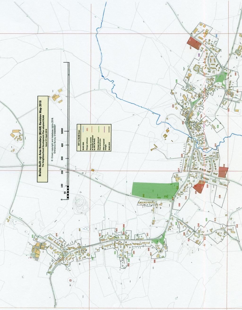
1 15. Built Up Area Boundary Definition The NDP group has been advised by SDC to create a new BUAB. The purpose of the boundary is to define areas of the village where it is felt that development, to meet our housing needs, is preferable. Whilst development can still take place outside the boundary, they are likely to be looked on less favourably than those inside the boundary. The group adopted the following process in setting up the new BUAB: - Use as a basis the 2000 boundary drawn up by SDC.
2 - Add in those houses built between 2011 and 2016 and those for which planning permission had been granted. Application House No. Type Included in New BUAB Park Farm/Crinkle Crankle 1 Full Planning - Outside BUAB Bio Life/Tommy's Turn 1 Built - Outside BUAB Miller's Way 8 Built YES Land off Sutton Lane 18 Out Planning YES Attens Byre 7 Out Planning YES Myrtle Cottage 1 Built YES Methodist Chapel 1 Built YES High Russett 1 Full Planning - Barn Sunnyside Nurseries 2 Built YES Sunnyside Nurseries 2 Built YES Old Farm House 1 Full Planning - Car Park Built Change of Use- Outside 7 Winderton 3 BUAB Vickerage Farm 1 Built - Outside BUAB Feldon House 1 Built change of use Brook House 1 Full Planning Friars Lane 1 Full Planning YES Gillets Lane 1 Full Planning YES Land Near Clock Tower 1 Full Planning YES Total 43 The following sites have been Allocated from the Call for Sites exercise, and on the advice of SDC have been included in the new BUAB. Development Site Name Score from Assess Tool No. of Affordable Houses Rank Compton Estates East
3 Righton Sutton Lane James 425e Compton Estates West Binns Manley Castle Hill Ln Pogmore Scarfe Chapel Clark Salt 538e Righton Cow Lane Righton Allotment Manley Castle Hill Ln S Scarfe Land 545/ Taylor Mid Henbrook Lane Manley High St Manley Centre N Taylor Mid + CA Taylor CA only Taylor whole field We then received some additional rules from SDC to help us define our new boundary: Defining the confines of a settlement The District Council has identified Built-Up Area Boundaries (BUABs) for selective settlements in successive Development Plans over the past twenty years. To provide the basis for doing this on a consistent basis, a set of guides was provided in the District Local Plan Review adopted in July 2006 (see Annexe 3 below). The BUABs for Stratford-upon-Avon and the eight Main Rural Centres have been carried forward into the Core Strategy using the same guides, and updated to reflect recent commitments and allocations. The revised versions are shown on the Policies Map that has been published to reflect the provisions of the Core Strategy. It is intended that BUABs will also be defined for each of the Local Service Villages. This will be done either though the Site Allocations Plan which the District Council is preparing or in a specific Neighbourhood Plan. The Site Allocations Plan will also consider any further amendments to the BUAB for Stratford-upon-Avon and the MRCs, as appropriate. It is acknowledged that Annexe 3 in the District Local Plan Review no longer has any formal status because the Plan as a whole was replaced by the Core Strategy when it
4 was adopted on 11 July However, for those settlements without a current BUAB, the District Council believes these guides remain appropriate until such time that revised/new BUABs have been identified. On that basis, it will continue to use them to assess whether a site lies within the confines of a Local Service Village when a development proposal is being considered. Note: Neighbourhood Plan Steering Groups are advised to use these guides when defining BUABs in their plans. Annexe 3 Guides for defining Built Up Area Boundaries Built-Up Area Boundaries have been defined for Stratford-upon-Avon and the eight Main Rural Centres identified in Policy STR.1. Much of the boundary between a settlement and the open countryside is clear-cut. However, subjective judgements have been necessary in respect of some areas of land on the periphery of settlements. It is important to achieve a high degree of consistency, whilst accepting that in some cases a particular local interpretation was justified. As a guide, the land uses mentioned below, where they are located on the periphery of a settlement, were treated in the following manner: 1. Included within the confines of a settlement: churchyards; community buildings and their immediate curtilage (ie. playing fields are excluded); areas of residential curtilage unless these areas are clearly paddocks more appropriately defined as non-urban. 2. Excluded from the confines of a settlement when on the edge of the built-up area: playing fields, including public, private and school playing fields; modern agricultural buildings; miscellaneous uses which may be located on the fringe of a settlement, eg. sewage treatment plants, electricity sub-stations, railway land, etc; allotments. Informal Planning Guidance Stratford-on-Avon District Council - Aug 2016 Map Creation and Revision Process Base map: SDC Local Plan, May 2000, Inset Map 2.2, page 238, scale 1:10,000. This map shows a broad, approximately 10 Meter wide, boundary which is often difficult to relate to features shown on a more accurate map. In places it appears not to relate to any identifiable features. Neighbourhood Planning Officer, Matthew Neal, provided the Brailes & Winderton Neighbourhood Development Plan Committee with a larger scale 1:6,000 digital copy of the same map in March This enabled an improved but still imprecise interpretation of the boundary. The map included changes he had made as an exercise to help show what a revised BUAB could potentially look like 1. These changes were interpreted by comparing both maps. The May 2000 boundary, as best could be interpreted, and without M Neal s changes, was drawn onto a larger scale map which had been adapted from one provided by SDC in February 2016 under Ordnance Survey license August :36:35 BST from Matthew Neal to Peter Jordan
5 The redrawn boundary was drawn to relate to features shown on the larger scale map where the May 2000 map suggested they related. Where no feature was apparent, or the May 2000 boundary clearly did not relate to a feature, the was drawn as closely as possible to match the center of the May 2000 boundary. All proposed changes to the May 2000 boundary, including those proposed in the 1:6,000 map by Matthew Neal, are listed in the table below. Accompanying map: Developing Map V11
6 001 South of allotments Allotment land in use. Do not extend leave as is 002 South of Gate Inn Garden land in use by Gate Inn. Do not reduce- leave as is 003 Empty plot by Myrtle Cottage Supersededsee 034 Field access, open green space, view to Castle Hill. to the road Ref. to South of Gilletts Lane Garden land. to red as ed to red 005 South of Pinders Knoll, Gilletts Lane, to exclude non land. to red as d to red 006 West of Chendawan garden boundary. to red as d to red 007 North of Brailes Hill House garden hedge. to red as ed to red 008 West of Brailes Hill House. Do not extend leave as is 009 Allandale, Henbrook Lane Planning Consent 08/01955/FUL Follow granted by PC 08/01955/FUL ed to outer red 010 Stoney Grove, Henbrook Land. to red as ed to red
7 011 North of Grove End Farm around Grove End Farm and driveway to Grove Cottage. BUAB updated around Grove End Farm only, confirmed by planning consent 17/02414/FUL Make correction to North of Grove End Farm driveway. Draw straight to west of Grove End Farm from Henbrook Farm house to western at Allendale given by PC 08/01955/FUL. Line should follow blue as marked on Plan 011 v2 New to plan 001v2 012 Henbrook Farm. Draw to align with fence, as per existing BUAB Plot South of Brook House Planning Consent 14/03461/FUL Include land granted planning ref 14/03461/FUL ed around planning consent. 014 Upper Grove End Farm Supersededsee 014 Planning Consent 12/00724/FUL. Include land granted planning ref 12/00724/FUL ed to planning consent. 014 Upper Grove End Farm Supersededsee 014 Connect new of BUAB with existing BUAB. Create new BUAB from where old BUAB crosses road to run SW edge of road to meet up with red of planning approval 12/00724/FUL. ed to highway boundary new plan 014 v2 used as guide
8 014 Upper Grove End Farm Follow hedge of garden at eastern edge In view of the granting of planning permission 17/01507/FUL, Richard Cheney and John Dudbridge were asked by the SG to review the of the BUAB at Upper Grove End Farm. Following a site visit RC and JD recommended to the SG that the of the BUAB should be redrawn as shown on Plan 014 v2. The reason being that in granting p p for 17/01507/FUL the planning officer quite clearly stated that the land surrounding the Upper Grove End Farm stables should not be viewed as creating a separate dwelling or land. Boundary drawn as per blue drawn on plan attached to 28/03/ Attens Byre Planning Consent 13/03160/OUT land granted planning ref 13/03160/OUT ed to red 016 Playground school boundary fence. to red as ed to red 017 The Swyre west of School Extension to garden refused permission ref 09/01557/FUL Do NOT extend, follow fence of neighbouring bungalows. d to red 018 Blakes Close and Millers Way boundary fence. ed to red 019 South east of Jeff s Close. Do not reduce as is
9 020 Track east of Blew Gates boundary fence. Do not reduce as is 021 East end of School Lane Supersededsee 021 Land is paddock land not used as Follow blue as marked on plan 021, two sites, A and B. d areas A & B to black on plan 0021c, two areas A & B 021 East end of School Lane Area B southern boundary further revised to align with central of three s on map as detailed on plan 021v2 022 Plumtree Farm House Follow red to red as ed to red 023 South of Home Farm House Land is paddock land not used as Do not reduce as is 024 West of Glebe Farm Land is in agricultural use. BUAB to follow edge of driveway to Glebe Farm. BUAB to follow edge of driveway to Glebe Farm. 025 Brook House garden Follow green to green as to green 026 The Willows Supersededsee 026 Aerial observation. Include whole site. Planning granted for tennis court (99/03166/FUL). Not done. Need detailed information. Planning consent not on.
10 026 The Willows Revised decision following site visit by R Cheney & J Dudbridge. Garden/domes tic land and tennis court associated with The Willows should be included in BUAB. 99/01366/FUL has no plans available of tennis court. Suggest BUAB to follow brook from existing of BUAB 2000 to SW end of tennis court as per plan 026, then in a straight to meet N boundary of site, follow boundary to meet existing BUAB 2000, marked blue. New extending to west end of tennis court using new plan 026 as guide. 027 Rear of Home Farm House etc. to green as ed to green 028 Churchyard extension Land is used for Parish Cemetery. to fence surrounding cemetery. ed to green 029 Woodlands to green as ed to green 030 South of Gilletts Lane Do not extend as is (Note004 changed) 031 North of Gilletts Lane Either As is
11 032 Brailes Hill Farm Supersededsee 032 below Both Include whole site. Planning granted for tennis court 90/00757FUL Not done. Need detailed information. Planning consent not on. 032 Brailes Hill Farm Revised decision following site visit by R Cheney & J Dudbridge. Include land used as 90/00757/FUL has no plans available of tennis court. BUAB to follow NE boundary of tennis court as on photo/ plan 032, marked blue New using map 032 as guide 033 Hornstone House to green as ed to green 034 Empty plot by Myrtle Cottage Supersededsee 048 See 003 See 003 See 003 See South of School Lane Supersededsee 035 below Do not reduce as is 035 South of School Lane Revised decision following site visits buildings Following representations from the neighbours of this site the Steering Group decided, at their meeting on 5/3/18, following site visits, that the of the BUAB at site 035 should follow the of the to Holly Cottage and then follow the south western edge of the old farm buildings to join School Lane, as shown on Plan 035. The Steering Group agreed, a) that the land on the south western side of this is clearly paddock land, b) the fence to the garden of Holly Cottage defines the boundary of the land associated with Holly Cottage and the old farm buildings form part of the built up area. to purple
12 036 Rear of Coppers Do not reduce as i s 037 Rear of Penstone House Do not reduce as is 038 Sutton Lane 18 houses Planning Consent granted for 18 houses, ref 13/03166/OUT ed to red 039 Attens Byre 7 houses Planning Consent granted for 7 houses, ref 13/03160/OUT ed to red Rectory Close P Jordan Land does not appear to be land or contain paraphernalia. Do not extend as is 041 Land to rear of Park Cottage, Old Park Cottage, Fairall Cottage. Land appears to be overgrown paddock and does not contain paraphanalia. Follow set by Breton House and Lambscote fence as per drawing 041 New along Breton House and Lambscote east boundary fence projected south to old BUAB.
13 042 Brailes House and land around. Land appears to be paddock or agricultural and does not contain paraphernalia. Revise of BUAB to exclude Brailes House and land around from Built Up Area as marked on Plan 042. Follow blue from Butchers Lane to rear of Hurdles. New as detailed on Plan Castle Hill Lane. gardens of this urban development. BUAB to follow blue as marked on Plan 043. New as detailed on Plan 043 except at garden/highway boundary along west edge of Castle Hill Lane and added along north garden/field boundary 044 Walnut Cottage, Six Bells Lane 05/02/18 this text changed re new planning consent original garden fence re consent 17/02889/LDE which does not extend Permitted Development Rights to the now approved garden area. Plan 044 Revised BUAB at north end of Line drawn as plan 044. New north boundary aligning with boundary between gardens of 5 & 6 Castle Hill. 045 Fisher Half Pound, Cow Lane. BUAB to exclude land that is overgrown paddock. Plan 045, revised BUAB at eastern side of site. Line drawn as plan 045.
14 046 Attens Byre. Include BUAB to include car parking area associated with Attens Byre. Plan 046, revised BUAB to follow hedge along southern road side. Line drawn as plan The Old Forge. Exclude BUAB to exclude land as it is overgrown paddock. Note this land is no longer a Brailes NDP Allocated Site, due to site size and ownership change. Plan 047, BUAB to follow fence at southern edge of garden associated with The Old Forge. Line drawn as plan Land Adjacent The Clock House And Stonecroft Barn Planning consent for 1 dwelling 17/02070/FUL to red 049 Allocated site Righton NDP allocated housing site Copy plan from R Cheney 31/03/18 around allocated site as plan 049v1 050 Allocated site Jeffries NDP allocated housing site Copy plan from R Cheney 31/03/18 around allocated site as plan 050v1 051 Allocated site Marquis of Northampton NDP allocated housing site Copy plan from R Cheney 31/03/18 around allocated site as plan 051v1
15
16 Dear all, As you know, we have fed back SDC s comments on the Regulation 14 pre-submission consultation following Cabinet in early April and you are currently taking the opportunity to review areas of the Plan. I am currently assisting Paul Harris with work on the Site Allocations Plan (SAP) SPD and part of this work has been to evaluate built-up-area boundaries for all LSV s listed in the Core Strategy. Paul had carried out some preliminary work on a number of village boundaries some months ago and one of the villages he had started to look at was Brailes I know we have provided comments previously on the settlement boundary through the original Reg.14 consultation, but I thought it would be useful to take a look at Paul s work and compare it with the settlement boundary currently being proposed through the NDP in order to see if there were any obvious differences between the two. When SDC carry out settlement boundary evaluations, we use the guides set out in Annexe 3 of the previous Local Plan, which I have previously passed through to you (see my of 1 st March). Our starting point for assessment of land parcels in and around the villages has been the BUAB as defined in the District Local Plan adopted in 2000, since this was the last time the village had a settlement boundary. Using this starting point, Annexe 3 guidance and google maps, I have assessed the NDP version of the settlement boundary and come up with a number of areas of difference. The differences are highlighted on the proposed BUAB SDC assessment map attached. SDC s reassessment of land parcels are in red and Brailes NDP boundary differences are in blue. As you will see, we consider a number of land parcels should be removed as they do not meet the criteria as set out in Annexe 3. We are also of the opinion that some of the minor changes proposed through the NDP map are not appropriate for the same reasons. The second map attached to this is SDC s version of what the Brailes settlement boundary would look like if we were producing a built-up-area boundary for the SAP having used the Annexe 3 criteria (you will see that I have not included the site allocations on this version, since these would not exist if there was not a NDP!). There is no obligation for the PC/NDP Group to make amendments based on these observations, but I thought this work may be of interest, particularly given the context of the Reg.14 consultation and the opportunity to consider other amendments to the Plan, should they be deemed appropriate.
17 I hope this is of interest/assistance. Please don t hesitate to contact me should you have any questions or would like to talk through the analysis. Kind regards, Matthew. Matthew Neal Policy Officer
18
Warwickshire County Council. Upper and Lower Brailes. Landscape Study
 Warwickshire County Council Upper and Lower Brailes Landscape Study Produced by WCC Landscape Architects March 2016 Landscape Assessment of Potential Development Sites within the parish of Brailes 1.0
Settlement Boundaries Methodology North Northumberland Coast Neighbourhood Plan (August 2016)
") Introduction This background paper sets out a methodology for the definition of settlement boundaries in the North Northumberland Coast Neighbourhood Plan. The neighbourhood plan is planning positively
Introduction This background paper sets out a methodology for the definition of settlement boundaries in the North Northumberland Coast Neighbourhood Plan. The neighbourhood plan is planning positively
INTRODUCTION CURRENT APPLICATION
 05/01805/FUL & 05/01807/LBC ERECTION OF A SINGLE DWELLING HOUSE WITH ANCILLARY ACCOMMODATION AT Flamingo Zoological Gardens, Olney Road, Weston Underwood FOR Mr A J Crowther (as amended by letter dated
Public Consultation. Land at Monks Farm, North Grove. Welcome
 Welcome Welcome to our public exhibition for development on Land at Monks Farm, orth Grove. Gallagher Estates and Gleeson Strategic Land are preparing an outline planning application for new homes, open
2014/0590 Reg Date 26/06/2014 Chobham
 2014/0590 Reg Date 26/06/2014 Chobham LOCATION: PROPOSAL: TYPE: APPLICANT: OFFICER: ASCOT PARK POLO CLUB, WESTCROFT PARK FARM, WINDLESHAM ROAD, CHOBHAM, WOKING, GU24 8SN Erection of a two storey detached
Welford-on-Avon. Neighbourhood Development Plan Welford-on-Avon Parish Council
 Welford-on-Avon Neighbourhood Development Plan 2011-2031 Welford-on-Avon Parish Council Parish Consultation: Summary Version December 2014 January 2015 Foreword This is the latest version of the Welford
Babergh and Mid Suffolk Joint Draft Local Plan Consultation, August 2017, Public Consultation
 Babergh and Mid Suffolk Joint Draft Local Plan Consultation, August 2017, Public Consultation Having reviewed the documents, the Society has made the following response: Housing Delivery Q 7. Do you agree
GUILDFORD BOROUGH GREEN BELT AND COUNTRYSIDE STUDY
 GUILDFORD BOROUGH GREEN BELT AND COUNTRYSIDE STUDY Volume II - Addendum On behalf of Guildford Borough Council PPG Ref : BNL.0287 April 2014 COPYRIGHT The conents of this document must not be copied or
Case Officer: Sarah Kay File No: CHE/14/00515/REM Tel. No: (01246) Plot No: 2/6132 Ctte Date: 15 th September 2014 ITEM 1
 Plot No: 2/6132 Ctte Date: 15 th September 2014 ITEM 1") Case Officer: Sarah Kay File No: CHE/14/00515/REM Tel. No: (01246) 345786 Plot No: 2/6132 Ctte Date: 15 th September 2014 ITEM 1 APPROVAL OF RESERVED MATTERS FROM APPLICATION CHE/12/00234/OUT (1) LAYOUT,
Case Officer: Sarah Kay File No: CHE/14/00515/REM Tel. No: (01246) 345786 Plot No: 2/6132 Ctte Date: 15 th September 2014 ITEM 1 APPROVAL OF RESERVED MATTERS FROM APPLICATION CHE/12/00234/OUT (1) LAYOUT,
Neighbourhood Plan Representation
 Date: 10 th November 2017 Neighbourhood Plan Representation Land to the east of Callow Hill Road, Alvechurch Introduction This representation has been prepared by RPS Planning and Development on behalf
CHANGE OF USE FROM PADDOCK TO RESIDENTIAL GARDEN LAND AT Yew Tree Cottage, Timpson Lane, Clifton Reynes FOR Iain Morrison
 08/01064/FUL CHANGE OF USE FROM PADDOCK TO RESIDENTIAL GARDEN LAND AT Yew Tree Cottage, Timpson Lane, Clifton Reynes FOR Iain Morrison INTRODUCTION Yew Tree Cottage is a detached dwelling at the northern
3(iv)(b) TCP/11/16(29)
(b) TCP/11/16(29)") 3(iv)(b) TCP/11/16(29) TCP/11/16(29) Planning Application 09/02229/AML Erection of a dwellinghouse, garage with upper floor accommodation and stables (Approval of Matters Specified by Conditions) at land
3(iv)(b) TCP/11/16(29) TCP/11/16(29) Planning Application 09/02229/AML Erection of a dwellinghouse, garage with upper floor accommodation and stables (Approval of Matters Specified by Conditions) at land
Plumpton Neighbourhood Development Plan Revised Pre Submission Document - Regulation 14 Consultation
 REPRESENTATIONS... Plumpton Parish Council Plumpton Neighbourhood Development Plan Revised Pre Submission Document - Regulation 14 Consultation Representations submitted on behalf of: Cala Homes (South
Kibworth Harcourt. Introduction. Introduction
 Introduction Introduction Welcome to this public exhibition on the proposals for the delivery of new homes on land at The Kibworths. The purpose of today s exhibition is to give you the opportunity to
SOUTH CAMBRIDGESHIRE DISTRICT COUNCIL. Planning and New Communities Director
 SOUTH CAMBRIDGESHIRE DISTRICT COUNCIL REPORT TO: Planning Committee 5 June 2013 AUTHOR/S: Planning and New Communities Director S/0747/13/FL HISTON Construction of Car Park at Histon Baptist Church, Station
Neighbourhood Planning Local Green Spaces
 Neighbourhood Planning Local Green Spaces Introduction... 2 1. Why green space is important... 4 2. Neighbourhood plans and green space... 6 3. Evidence... 8 Statutory designations... 9 Green space audit...
Site ref: AS06 Site Name or Address: Murreys Court, Agates Lane
 Site ref: AS06 Site Name or Address: Murreys Court, Agates Lane Proposed Land Use: Total Site Area (Ha): Housing 1.85 Ha Description: It is understood that the owner has no plans to dispose of the site
About 10% of the Borough's population lives in the seven rural parishes. Population figures from the 1991 census are given below:-
 8. THE DISTRICT VILLAGES 8.1 Population About 10% of the Borough's population lives in the seven rural parishes. Population figures from the 1991 census are given below:- Village No. of Persons Cottingham
Welford-on-Avon Neighbourhood Plan Consultation Event Sunday, 6 April Your name Your address
 Welford-on-Avon Neighbourhood Plan Consultation Event Sunday, 6 April 2014 Your name Your email address Please either: - complete this feedback form and put it in the box before leaving the Memorial Hall
Rudy Parish Neighbourhood Plan Steering Group Meeting 6/8/2018. Proposed Green Spaces (Continued from SG meeting of 2/7/18)
") Rudy Parish Neighbourhood Plan Steering Group Meeting 6/8/2018 Proposed Green Spaces (Continued from SG meeting of 2/7/18) NPPF: Green Space Designation The Local Green Space designation will not be appropriate
Rudy Parish Neighbourhood Plan Steering Group Meeting 6/8/2018 Proposed Green Spaces (Continued from SG meeting of 2/7/18) NPPF: Green Space Designation The Local Green Space designation will not be appropriate
DONCASTER METROPOLITAN BOROUGH COUNCIL. PLANNING COMMITTEE - 15th October Expiry Date:
 DONCASTER METROPOLITAN BOROUGH COUNCIL PLANNING COMMITTEE - 15th October 2013 Application 3 Application Number: 13/01158/FUL Application Expiry Date: 31st July 2013 Application Type: Full Application Proposal
SOUTH CAMBRIDGESHIRE DISTRICT COUNCIL. Director of Development Services
 SOUTH CAMBRIDGESHIRE DISTRICT COUNCIL REPORT TO: Development and Conservation Control Committee 5 th April 2006 AUTHOR/S: Director of Development Services S/2290/05/F Haslingfield House (Revised Design)
WILMCOTE NEIGHBOURHOOD PLAN
 WILMCOTE NEIGHBOURHOOD PLAN 1. Introduction. 1.1 David Holmes Planning Ltd has been instructed to advise Wilmcote Parish Council, who wish to prepare a Neighbourhood Plan. In particular we are asked to
SOUTH CAMBRIDGESHIRE DISTRICT COUNCIL. Planning and New Communities Director
 SOUTH CAMBRIDGESHIRE DISTRICT COUNCIL REPORT TO: Planning Committee 9 January 2013 AUTHOR/S: Planning and New Communities Director S/2270/12/FL FEN DRAYTON 850m long flood defence embankment ranging in
Mendip Local Plan Part II: Sites and Policies - Issues and Options Consultation MDC LPP2 consultation response.pdf
 From: Nicola Duke Sent: 15 February 2018 11:17 To: PlanningPolicy Subject: Mendip Local Plan Part II: Sites and Policies - Issues and Options Consultation Attachments: 180215
A payment of 1080 is due in this instance, for a meeting and follow up written response, and will be made by card over the phone.
 JPPC ref: AG/6002 18 th September 2014 Planning Services Vale of White Horse District Council Benson Lane Crowmarsh Gifford Wallingford OX10 8ED Dear Sir/Madam REQUEST FOR PRE-APPLICATION ADVICE RE: RESIDENTIAL
Ward: Southbourne. White Croft 14 Breach Avenue Southbourne West Sussex PO10 8NB
 Parish: Southbourne Ward: Southbourne Proposal Site SB/15/01827/FUL Erection of a detached chalet bungalow. White Croft 14 Breach Avenue Southbourne West Sussex PO10 8NB Map Ref (E) 477023 (N) 106593 Applicant
To secure a Green Belt around Cambridge whose boundaries are clearly defined and which will endure for the plan period and beyond.
 4. GREEN BELT OBJECTIVES GB/a GB/b GB/c GB/d To secure a Green Belt around Cambridge whose boundaries are clearly defined and which will endure for the plan period and beyond. To maintain the purposes
Draft Hailey Neighbourhood Plan
 Persimmon Homes (Wessex) Draft Hailey Neighbourhood Plan Representations to West Oxfordshire District Council s Regulation 16 Consultation December 2018 2 Copyright 2018 Persimmon Homes Ltd. All rights
LONGDEN VILLAGE DEVELOPMENT STATEMENT
 LONGDEN VILLAGE DEVELOPMENT STATEMENT 2017-2027 1 Longden Development Statement 2017-2027 15/01/18 1. Background 1.1 Longden Village Longden village is a very rural and traditional community first mentioned
LETTER OF OBJECTION LAND TO THE SOUTH WEST OF FORGE GARAGE, HIGH STREET, PENSHURST, KENT, TN11 8BU
 Senior Planning Officer Andrew Byrne Sevenoaks District Council Community & Planning Services PO Box 183 Argyle Road Sevenoaks Kent TN13 1GN 04 November 2011 Your Ref: 11/02258/FUL For the attention of
Blandford Forum Town Council, Blandford St Mary Parish Council and Bryanston Parish Council
 Blandford Forum Town Council, Blandford St Mary Parish Council and Bryanston Parish Council Blandford + Neighbourhood Plan 2 Pre-Submission Plan Consultation (November 2018) Representations submitted on
OKEFORD FITZPAINE NEIGHBOURHOOD PLAN
 OKEFORD FITZPAINE NEIGHBOURHOOD PLAN Dear Parishioner, The Neighbourhood Plan Project Team have prepared this leaflet to summarise the full Neighbourhood Plan document. It provides a summary of the Vision,
1. Listed Building and Conservation Area considerations 2. Protection of Known Archaeological Remains 3. Parking
 08/01222/FUL ERECTION OF SINGLE STOREY SIDE EXTENSION TO CHURCH TO PROVIDE FOR PARISH HALL (RESUBMISSION OF 08/00206/FUL) AT St Mary And St Giles Church, Church Street, Stony Stratford FOR Rev R Northing
1. Objectives of this consultation
 1. Objectives of this consultation Provide an update on the results of the December 2014 consultation Provide a summary of the Pre-Submission Plan which is now out for formal consultation To ask for your
WELCOME TO THE NEW WILTON PARK
 WELCOME TO THE NEW WILTON PARK VISION HISTORY OF WILTON PARK TOWARDS A PLANNING APPLICATION Our objective is to create a truly outstanding environment at Wilton Park. At the heart of our proposals is a
Copyright Nigel Deeley and licensed for reuse under this Creative Commons Licence
 1 Copyright Nigel Deeley and licensed for reuse under this Creative Commons Licence Prepared by the Neighbourhood Plan Steering Group on behalf of Garway Parish Council with assistance from 2 Table of
Brailes Parish outlined in red the Neighbourhood Development Plan Area
 1 Brailes Parish outlined in red the Neighbourhood Development Plan Area Published by Brailes Parish Council based on the work of the Neighbourhood Development Plan Steering Group published March 2017
Ebbsfleet Development Corporation
 Title of Paper Planning and Housing Delivery Report September 2018 Presented by Sub-Committee Mark Pullin, Chief Planning Officer Planning Committee Purpose of Paper and Executive Summary This paper provides
Agenda Update Sheet. Planning Committee A
 Agenda Update Sheet Planning Committee A Date: 22 nd June 2017 Agenda Section 5: Applications Part I Recommended for Approval ITEM: 1 DM/16/5502 Summary of Consultees Surrey County Council No objection
an Inspector appointed by the Secretary of State for Communities and Local Government
 Appeal Decision Site visit made on 23 January 2017 by Gareth Wildgoose BSc (Hons) MSc MRTPI an Inspector appointed by the Secretary of State for Communities and Local Government Decision date: 6 February
Cookham Parish Council s Response to The Draft Local Borough Plan
 Cookham Parish Council s Response to The Draft Local Borough Plan As Agreed at the Planning Committee Meeting on 10 th January 2017. Designation of Poundfield as a Local Green Space The Parish Council
SOUTH CAMBRIDGESHIRE DISTRICT COUNCIL. REPORT TO: Planning Committee 1 April 2015 Planning and New Communities Director
 SOUTH CAMBRIDGESHIRE DISTRICT COUNCIL REPORT TO: Planning Committee 1 April 2015 AUTHOR/S: Planning and New Communities Director Application Number: Parish(es): Proposal: Site address: Applicant(s): Recommendation:
CA//17/02777/FUL. Scale 1:1,250. Planning Services Canterbury City Council Military Road Canterbury Kent CT1 1YW
 O CA//17/02777/FUL Scale 1:1,250 Map Dated: 15/03/2018 Planning Services Canterbury City Council Military Road Canterbury Kent CT1 1YW AGENDA ITEM NO 16 PLANNING COMMITTEE APPLICATION NUMBER: SITE LOCATION:
PLANNING COMMITTEE REPORT
 PLANNING COMMITTEE REPORT TO: BY: Planning Committee South Development Manager DATE: 17 January 2017 DEVELOPMENT: SITE: WARD: APPLICATION: APPLICANT: Change of use of land to caravan site for stationing
Local Development Scheme
 Local Development Scheme 2012 2016 The Local Development Scheme (LDS) is a project plan that outlines how and when the Authority will update its planning policies and other associated documents. It ensures
Built Up Area Boundary (BUAB)
") Parish Boundary Built Up Area Boundary (BUAB) Potential Sites Map not to scale DWELLING SIZE POLICY Residential developments must provide a mix of dwelling sizes (market and affordable) that reflect the
Parish Boundary Built Up Area Boundary (BUAB) Potential Sites Map not to scale DWELLING SIZE POLICY Residential developments must provide a mix of dwelling sizes (market and affordable) that reflect the
Ward: West Wittering. Proposal Change of use from public highway pavement to residential garden use.
 Parish: West Wittering Ward: West Wittering WW/17/03295/FUL Proposal Change of use from public highway pavement to residential garden use. Site Izora 1 Watersedge Gardens West Wittering PO20 8RA Map Ref
Reserved Matters application for a site that straddles the boundary between CBC and BBC
 BBC APPLICATION 15/02682/MAR NUMBER CBC APPLICATION CB/15/04294/RM NUMBER LOCATION Wixams Land at former storage depot, Bedford Road, Wilstead Bedfordshire PROPOSAL Reserved Matters Application for Strategic
Ullswater Court 92 Holders Hill Road London NW4 1LN
 Location Ullswater Court 92 Holders Hill Road London NW4 1LN Reference: 17/5396/CON Received: 18th August 2017 Accepted: 18th August 2017 Ward: Finchley Church End Expiry 13th October 2017 Applicant: IBSA
Final Revisions: Provision of single storey modular classroom and associated works.
 LOCATION: St Catherines Catholic Primary School, Vale Drive, Barnet, Herts, EN5 2ED REFERENCE: B/01924/12 Received: 17 May 2012 Accepted: 28 May 2012 WARD(S): Underhill Expiry: 23 July 2012 Final Revisions:
Planning Application 13/00952/FULLS at Ampfield Hill, Romsey, Test Valley: Great Crested Newt Survey Following on From Ecological Assessment
 10 June 2014 Mr Allan Clark esq Ampfield Parish Council Blue Haze Ampfield Hill Ampfield Romsey SO51 9BD By email only Our Ref: P13/46 Dear Mr Clark Planning Application 13/00952/FULLS at Ampfield Hill,
The eight-week period for this application expires on 5 October 2006.
 06/01213/FUL CHANGE OF USE FROM AGRICULTURAL LAND TO PRIVATE CAR PARK AND NEW FENCING. AT Land To The South of Perceval Almhouses, Lower Weald, Calverton FOR Calverton Parochial Church Council INTRODUCTION
Balcombe Neighbourhood Plan. Habitats Regulations Assessment Screening Report
 Balcombe Neighbourhood Plan Habitats Regulations Assessment Screening Report Produced for Regulation 14 of the Neighbourhood Planning (General) Regulations 2012 17 th July 2015 1.0 Introduction 1.1 This
Perth and Kinross Council Development Management Committee 8 June Pre-Application Report by Development Quality Manager
 Perth and Kinross Council Development Management Committee 8 June 2016 5(3)(i) 16/259 Pre-Application Report by Development Quality Manager Residential development at St Martins Road, Land 120 metres West
New House Farm, Risbury, Nr Leominster, Herefordshire
 New House Farm, Risbury, Nr Leominster, Herefordshire A beautiful farmhouse and numerous extremely versatile outbuildings, in extensive gardens and paddocks with superb views. 7 Acres LOCATION Leominster
an Inspector appointed by the Secretary of State for Communities and Local Government
 Appeal Decision Hearing held on 27 May 2015 Site visit made on 27 May 2015 by L Gibbons BA (Hons) MRTPI an Inspector appointed by the Secretary of State for Communities and Local Government Decision date:
an Inspector appointed by the Secretary of State for Communities and Local Government Decision date: 13 February 2018
 Appeal Decision Site visit made on 23 January 2018 by Stephen Hawkins MA MRTPI an Inspector appointed by the Secretary of State for Communities and Local Government Decision date: 13 February 2018 Appeal
CAERNARFON DEPENDENCY CATCHMENT AREA
 CAERNARFON DEPENDENCY CATCHMENT AREA GWYNEDD UNITARY DEVELOPMENT PLAN - HOUSING Map not to scale Dependency Catchment Area Location 2 Caernarfon Topic Housing To the rear of Bro Eglwys, Bethel. Grid Ref.
Derry City and Strabane District Council Planning Committee Report
 Derry City and Strabane District Council Planning Committee Report COMMITTEE DATE: 29 th November 2017 APPLICATION No: APPLICATION TYPE: PROPOSAL: LOCATION: APPLICANT: AGENT: LA11/2016/0854/O Outline Shared
Appendix I: Addendum to Development Frameworks Evidence Paper
 Appendix I: Addendum to Development Frameworks Evidence Paper Ref. o. Table 3 Suggested village frameworks amendments from Proposed Submission with Council's assessment Key shaded rows indicate suggested
PART 1 EAST HAMPSHIRE DISTRICT COUNCIL SECTION 1 SCHEDULE OF APPLICATION RECOMMENDATIONS
 PART 1 EAST HAMPSHIRE DISTRICT COUNCIL PLANNING COMMITTEE REPORT OF THE HEAD OF PLANNING Applications to be determined by the Council as the Local Planning Authority SECTION 1 SCHEDULE OF APPLICATION RECOMMENDATIONS
Called-in by Cllr Richard Stay for the following reasons: DETERMINE. Application recommended for refusal
 Item No. 13 APPLICATION NUMBER CB/15/00275/OUT LOCATION Prebendal Farm, Grove Road, Slip End, Luton, LU1 4BZ PROPOSAL Outline Development: Redevelopment of land previously used as a farm yard to residential
Planning Appraisal. Land Adjacent to Norton House Hotel, Edinburgh. May 2017
 Planning Appraisal Land Adjacent to Norton House Hotel, Edinburgh May 2017 Clarendon Planning and Development Ltd Introduction Clarendon Planning and Development Ltd have been requested to provide a summary
Planning and Regulatory Committee 20 May Applicant Local Councillor Purpose of Report
 Planning and Regulatory Committee 20 May 2014 7. APPLICATION FOR PLANNING PERMISSION FOR THE CARRYING-OUT OF DEVELOPMENT PURSUANT TO PLANNING PERMISSION REFERENCE NUMBER 603451 DATED 28 FEBRUARY 2007 WITHOUT
The Neighbourhood Planning Process in Lavenham
 The Neighbourhood Planning Process in Lavenham 21 March 2016 Rachel Hogger MRTPI rachel@modicumplanning.uk Tel: 01353 969785/07802 731159 MODICUM PLANNING Neighbourhood planning support for communities
Developers and Council attack Southam Road - again
 Press Release 125 Developers and Council attack Southam Road - again Many residents of Hanwell Fields received a letter from the Cherwell District Council yesterday called NEIGHBOURHOOD NOTIFICATION. This
St Michaels C of E Junior & Infant School, Nantmel Grove, Bartley Green, Birmingham, B32 3JS
 Committee Date: 06/03/2014 Application Number: 2013/08595/PA Accepted: 19/11/2013 Application Type: Full Planning Target Date: 14/01/2014 Ward: Bartley Green St Michaels C of E Junior & Infant School,
HURSTPIERPOINT SAYERS COMMON PARISH COUNCIL
 HURSTPIERPOINT SAYERS COMMON PARISH OFFICE TRINITY ROAD HURSTPIERPOINT HASSOCKS WEST SUSSEX BN6 9UY TEL: 01273 833264 FAX: 01273 834976 E-MAIL: HURSTPIERPOINT.PC@BTINTERNET.COM WEB SITE: WWW.HURSTPIERPOINT-PC.ORG.UK
UTT/17/2075/FUL - (BERDEN) (Referred to Committee by Councillor Janice Loughlin. Reason: In the Public Interest)
 (Referred to Committee by Councillor Janice Loughlin. Reason: In the Public Interest)") UTT/17/2075/FUL - (BERDEN) (Referred to Committee by Councillor Janice Loughlin. Reason: In the Public Interest) PROPOSAL: LOCATION: APPLICANT: Amendments to the design of a scheme for a 49.99MW battery
UTT/17/2075/FUL - (BERDEN) (Referred to Committee by Councillor Janice Loughlin. Reason: In the Public Interest) PROPOSAL: LOCATION: APPLICANT: Amendments to the design of a scheme for a 49.99MW battery
Ashtead Neighbourhood Forum Site Assessment AS03 Lime Tree Lodge, Farm Lane. Site address: Lime Tree Lodge, Farm Lane. Proposed Land Use:
 Site ref: AS03 Site address: Lime Tree Lodge, Farm Lane Proposed Land Use: Total Site Area (Ha): Housing 1.25ha Description The site is located off Farm Lane at the junction with Park Lane. To the north
Derry City and Strabane District Council Planning Committee Report
 Derry City and Strabane District Council Planning Committee Report COMMITTEE DATE: 23 rd March 2016 APPLICATION No: APPLICATION TYPE: PROPOSAL: LOCATION: APPLICANT: LA11/2015/0395/F Residential Development
Land at Rampton Road. Cottenham
 Land at Rampton Road Cottenham Introduction TEP is preparing an outline planning application for 54 dwellings on 6.9 hectares of land adjacent to Rampton Road, Cottenham on behalf of the owners Cambridgeshire
Toddington Central Bedfordshire Stage 3 Green Belt Study December 2017
 Toddington Central Bedfordshire Stage 3 Green Belt Study December 2017 Site: ALP086 - Middle Lakes, Toddington Site size (ha): 2.83 Site: ALP086 - Middle Lakes, Toddington Site size (ha): 2.83 Site description
Great Easton Sustainable Housing Development Sites - Site Seven, Broadgate extension site SHLAA Ref HSG/03)
") Great Easton Sustainable Housing Development Sites - Site Seven, Broadgate extension site SHLAA Ref HSG/03) 1. Introduction The Great Easton Neighbourhood Plan Group are preparing a Neighbourhood Plan
Great Easton Sustainable Housing Development Sites - Site Seven, Broadgate extension site SHLAA Ref HSG/03) 1. Introduction The Great Easton Neighbourhood Plan Group are preparing a Neighbourhood Plan
Welcome. Land adjacent Sandy Lane WALTHAM CHASE THE PROPOSED SITE
 Land adjacent Sandy Lane WALTHAM CHASE Existing Linden Homes developments Welcome Welcome to Linden Homes Southern s ( Linden ) public exhibition about its proposals for a range of high-quality homes for
APP/G1630/W/15/
 Appeal Decision Site visit made on 20 October 2015 by William Fieldhouse BA (Hons) MA MRTPI an Inspector appointed by the Secretary of State for Communities and Local Government Decision date: 20 November
Noted - but CA designation is not a static process and change can take place albeit in a more controlled way.
 PLAISTOW CONSERVATION AREA APPENDIX 1 CHARACTER APPRAISAL AND MANAGEMENT PLAN RESULT OF PUBLIC CONSULTATION Draft # 1 12 November 2012. No. Name Comment Response Action 1 Peter Luttman- Johnston (i) Does
PENRHYN QUARRY BETHESDA GWYNEDD. Proposed Inert Recycling Facility DESIGN AND ACCESS STATEMENT
 PENRHYN QUARRY BETHESDA GWYNEDD Proposed Inert Recycling Facility DESIGN AND ACCESS STATEMENT September 2010 PENRHYN QUARRY, BETHESDA, GWYNEDD Proposed development of an Inert Waste Recycling Facility
Site Assessment Technical Document Appendix A: Glossary
 Central Bedfordshire Council www.centralbedfordshire.gov.uk Site Assessment Technical Document Appendix A: Glossary July 2017 1.1.11-1 - ii Appendix A: Glossary Term Agricultural Land Classification AONB
EAST OF ENGLAND OFFICE
 Mr Philip Isbell Direct Dial: 01223 582751 Mid Suffolk District Council 131 high Street Our ref: P00524468 Needham Market Ipswich Suffolk IP6 8DL 18 January 2017 Dear Mr Isbell T&CP (Development Management
DEVELOPMENT MANAGEMENT REPORT
 ITEM A08-1 DEVELOPMENT MANAGEMENT REPORT TO: BY: DATE: DEVELOPMENT: SITE: WARD: APPLICATION: APPLICANT: Development Management Committee Development Manager Proposed live/work unit in connection with existing
Tennis Court Rear Of 3-5 Corringway London NW11 7ED
 Location Tennis Court Rear Of 3-5 Corringway London NW11 7ED Reference: 18/4122/FUL Received: 3rd July 2018 Accepted: 3rd July 2018 Ward: Garden Suburb Expiry 28th August 2018 Applicant: Ms Sarah Robinson
WELCOME. Olney Road, Lavendon INTRODUCTION. The Site. The Application. The Need for Housing. A Sustainable Location LAVENDON TURVEY OLNEY ROAD
 0 WELCOME INTRODUCTION Gladman Developments Ltd have successfully invested in communities throughout the UK over the past 0 years, developing high quality and sustainable residential, commercial and industrial
Mr & Mrs Connolly per Pump House Designs Pump House Yard The Green SEDLESCOMBE, East Sussex. TN33 0QA
 AGENDA ITEM NO: 5 (c) Report to: PLANNING COMMITTEE Date: 03 June 2015 Report from: Head of Housing and Planning Services Application Address: Proposal: Application No: Recommendation: Ward: File No: Applicant:
Report Author/Case Officer: Joanne Horner Contact Details:
 APP 04 Application Number: 16/00140/FUL Other Two storey side extension to existing dwelling and formation of hard standing to provide parking for number 54 (Resubmission of withdrawn application 15/02852/FUL)
Test Valley Borough Council. Strategic Housing Land Availability Assessment (SHLAA)
") Test Valley Borough Council Strategic Land Assessment (SHLAA) Appendix 2 Southern Test Valley Sites Where a Change in Policy is Required for Residential Development Final Version as at 1 st April 2014
Test Valley Borough Council Strategic Land Assessment (SHLAA) Appendix 2 Southern Test Valley Sites Where a Change in Policy is Required for Residential Development Final Version as at 1 st April 2014
PLANNING COMMITTEE. 14 October 2014
 AGENDA ITEM NO 8 PLANNING COMMITTEE 14 October 2014 APPLICATION NUMBER : CA//14/01744/FUL PROPOSAL : Extension and conversion of roof space of an existing detached bungalow together with enhanced parking
Environmental and Landscape Mapping
 Environmental and Landscape Mapping In support of the Calveley Neighbourhood Plan November 2016 Project Name and Number: Calveley Neighbourhood Plan 16-025 Document Name and Revision: Environmental and
SOUTH CAMBRIDGESHIRE DISTRICT COUNCIL. Executive Director (Operational Services) Corporate Manager (Planning and New Communities)
 Corporate Manager (Planning and New Communities)") SOUTH CAMBRIDGESHIRE DISTRICT COUNCIL REPORT TO: Planning Committee 12 January 2011 AUTHOR/S: Executive Director (Operational Services) Corporate Manager (Planning and New Communities) Notes: S/1848/10
SOUTH CAMBRIDGESHIRE DISTRICT COUNCIL REPORT TO: Planning Committee 12 January 2011 AUTHOR/S: Executive Director (Operational Services) Corporate Manager (Planning and New Communities) Notes: S/1848/10
19 th October FAO Paul Lewis Planning Policy Branch Planning Division Welsh Assembly Government Cathays Park Cardiff CF10 3 NQ
 19 th October 2009 FAO Paul Lewis Planning Policy Branch Planning Division Welsh Assembly Government Cathays Park Cardiff CF10 3 NQ Dear Sir / Madam Technical Advice Note 6 Planning for Sustainable Rural
Ashtead Neighbourhood Forum Site Assessment AS07 Old Chalk Pit, Pleasure Pit Road. Site ref: AS07 Site address: Old Chalk Pit, Pleasure Pit Road
 Site ref: AS07 Site address: Old Chalk Pit, Pleasure Pit Road Proposed Land Use: Total Site Area (Ha): Housing 0.7ha Description: The site was formally an old chalk pit that has been partially filled and
Strategic Environmental Assessment of the Brailes & Winderton Neighbourhood Plan. SEA Screening Document April 2017
 Strategic Environmental Assessment of the Brailes & Winderton Neighbourhood Plan SEA Screening Document April 2017 Strategic Environmental Assessment of the Brailes & Winderton Neighbourhood Plan SEA Screening
ENVIRONMENTAL AND LANDSCAPE MAPPING
 APPENDIX IV : Environmental and Landscape Mapping ENVIRONMENTAL AND LANDSCAPE MAPPING Calveley Neighbourhood Plan November 2016 ENVIRONMENTAL AND LANDSCAPE MAPPING Calveley Neighbourhood Plan Calveley
Minutes of Neighbourhood Plan Steering Group Meeting December 11th 2014
 Minutes of Neighbourhood Plan Steering Group Meeting December 11th 2014 Present Lyn Goodfellow (Chairman), Peter Colton, Christina Brown, Keith Herring Barry Carter 1. Apologies Mary Buxton, Andy Bosley,
Design and Access Statement. Redevelopment of Marcris House, Coopersale Lane, Theydon Boise to provide 11 new apartments.
 Design and Access Statement for Redevelopment of Marcris House, Coopersale Lane, Theydon Boise to provide 11 new apartments Prepared by ISL Architecture For Chigwell Homes Ltd dated October 2015 1 Introduction
Newcourt Masterplan. November Exeter Local Development Framework
 Newcourt Masterplan November 2010 Exeter Local Development Framework Background The Exeter Core Strategy Proposed Submission sets out the vision, objectives and strategy for the development of Exeter up
07/00934/MKPCO OUTLINE PERMISSION FOR RESIDENTIAL DEVELOPMENT OF UP TO 1600 DWELLINGS (35.55 HECTARES), UP TO 3
, UP TO 3") 07/00934/MKPCO AND 07/00936/MKPCO OUTLINE PERMISSION FOR RESIDENTIAL DEVELOPMENT OF UP TO 1600 DWELLINGS (35.55 HECTARES), UP TO 3.14 HECTARES OF MIXED USES (CLASS A1, A2, A3, A4, A5, C3 AND D1 USES INCLUDING
07/00934/MKPCO AND 07/00936/MKPCO OUTLINE PERMISSION FOR RESIDENTIAL DEVELOPMENT OF UP TO 1600 DWELLINGS (35.55 HECTARES), UP TO 3.14 HECTARES OF MIXED USES (CLASS A1, A2, A3, A4, A5, C3 AND D1 USES INCLUDING
1 The development hereby permitted shall be carried out in accordance with the following approved plans:
 Location The Avenue Tennis Club The Avenue London N3 2LE Reference: 16/6509/FUL Received: 10th October 2016 Accepted: 10th October 2016 Ward: Finchley Church End Expiry 5th December 2016 Applicant: Mrs
Lower Hollow Copse. Questions and Answers on Proposals for Permanent Gypsy and Traveller Accommodation
 Lower Hollow Copse Questions and Answers on Proposals for Permanent Gypsy and Traveller Accommodation 0 Why does Mid Sussex District Council need to provide permanent gypsy and traveller accommodation?