WEST OAKLAND SPECIFIC PLAN & DRAFT ENVIRONMENTAL IMPACT REPORT
|
|
|
- Cameron Walton
- 5 years ago
- Views:
Transcription


1 WEST OAKLAND SPECIFIC PLAN & DRAFT ENVIRONMENTAL IMPACT REPORT Landmarks Preservation Advisory Board Public Hearing February 10,
2 Specific Plan Overview Plan Area is generally bounded by I-580 to the north, I-980 to the east, and I-880 to the south & west. Also includes the Oakland portion of the East Bay Bridge Shopping Center (above I-580), and the industrial area centered on 3rd Street (below I-880). ~1900 Acres / 6,340 parcels 2

3 Plan Area 3
4 Specific Plan Contents Establishing appropriate land use policies & regulations Attracting new desired businesses & industries Identifying preferred development concepts Retaining Industrial land and jobs Ensuring equitable economic development Improving area infrastructure Addressing Crime Combating blight Fostering the arts Preserving historic resources Fostering community health Enhancing transit Encouraging open space Enhancing residential neighborhoods Increasing residential development Attracting more retail establishments Supporting affordable housing Retaining educational resources Remediating contaminated sites Augmenting design guidelines 4
5 Specific Plan Purpose Provide comprehensive & multi-faceted Strategies for development of key parcels Attract development to longstanding under-utilized commercial and industrial areas Establish a land use and transportation framework for West Oakland district Encourage new Economic Development while preserving existing residential neighborhoods 5
6 Specific Plan Vision Industrial areas are preserved & contribute to economic vitality, supporting clean, low-impact industries that provide living wage jobs for local residents Housing continues to be affordable & reflects range of housing options Character of historic neighborhoods has been maintained New housing development is transit-oriented and transit served 6
7 Specific Plan Vision, cont. Transit connections between West Oakland BART station, residential neighborhoods &employment, cultural & commercial centers are improved Neighborhood commercial areas (7th Street, San Pablo Avenue) have been revitalized Environmental quality & community health have been improved West Oakland continues to be socially & culturally diverse with a strong sense of community 7
8 Historic Context Plan Area contains following historic resources: Local Register Properties- 1,421 Designated Historic Properties- 32 Area of Primary Importance Properties Area of Secondary Importance Properties Several Historic Districts: Oakland Point / Southern Pacific Railroad Industrial Landscape District / Oak Center District S-7 Preservation Combining Zone 8
9 Development Concepts Opportunity Sites Plan is intended to facilitate new growth and development that is most likely to occur on underutilized properties, sites available as a result of the relocated I-880 freeway, and additional sites expected to be vacated as their current uses relocate to the former Oakland Army Base. These sites are identified in the Plan as Opportunity Sites. 9

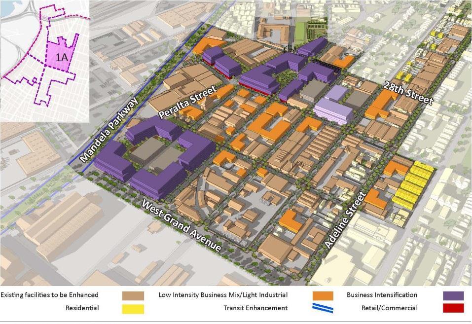
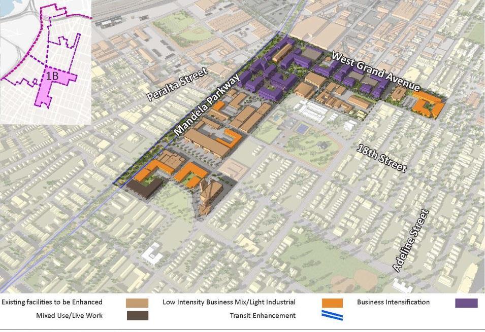
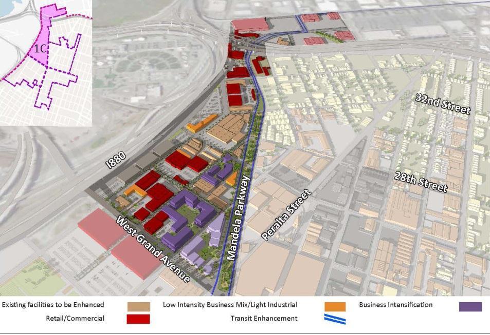
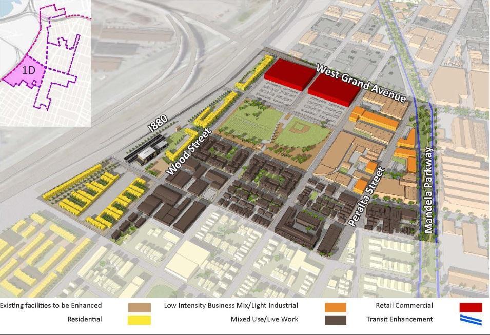
10 Development Concepts Opportunity Areas The Specific Plan groups similar Opportunity Sites concentrated in a compact location into larger geographic units termed Opportunity Areas. The WOSP recommends a land use vision and strategies for guiding future development of these Opportunity Areas in particular: Mandela / West Grand Opp. Area 7 th Street Opportunity Area 3 rd Street Opportunity Area San Pablo Avenue Opp. Area 10
11 Development Vision Mandela/ West Grand Area Opportunity Area Promote a mix of business activities & a range of jobs at varying skill / education levels Retain and expand commercial and industrial businesses Attract traditional light industrial /commercial uses Discourage heavy industrial near residential 11
12 12
13 Development Vision 7 th Street Opportunity Area Encourage Transit-Oriented Development surrounding West Oakland BART Station Revitalize 7 th Street with neighborhood-serving ground floor commercial uses Enliven 7 th Street as a celebration of West Oakland s cultural history of music, art and entertainment Minimize noise from overhead BART rails Address environmental remediation and encourage development of key, selected sites 13
14 14
15 Development Vision 3 rd Street Opportunity Area Promote a more vibrant business & employment center, focusing on manufacturing & light industrial uses that benefit from adjacency to Port Encourage commercial, dining & entertainment uses as infill enhancements in older warehouse buildings Continue to prohibit residential in this area 15
16 16
17 Development Vision San Pablo Ave Opportunity Area Encourage mixed use development of multi-family residential development over ground floor commercial activities Enhance streetscape and increase commercial uses to activate street Revitalize existing commercial center on south side of West Grand Avenue 17
18 18

19 Proposed General Plan & Zoning Amendments 19
20 Other Plan Elements Overlay Zones & Design Guidelines to refine existing Zoning requirements Transportation Enhancements to link West Oakland BART Station and existing/future West Oakland employment centers to MacArthur / 19 th /12 th St. BART Stations, Downtown, and Jack London Square Strategies for Retaining Existing West Oakland Assets - Historic Resources, Creative Economy/Cultural Arts 20
21 Other Plan Elements, cont. Strategies for Removing Barriers to Economic Development - Blight, Crime, Brownfields Transportation & Infrastructure Improvements Support for Urban Open Space Concepts - West Oakland Reforestation Plan, West Oakland Walk Recommendations for Broader Concerns - Affordable Housing, Equitable Development & Community Health Implementation Program 21
22 Draft Environmental Impact Report (DEIR) Aesthetics, Shadow & Wind Air Quality Biological Resources Cultural & Historic Resources Geology & Soils Greenhouse Gas Emissions/Climate Change Hydrology & Water Quality Land Use & Planning Noise Population, Housing & Employment Public Services & Recreation Transportation Utilities & Service Systems 22
23 Draft Environmental Impact Report, cont. Analyzes impacts of development recommended in the West Oakland Specific Plan Cultural & Historic Resources findings (Impact CR-1): Plan doesn t propose demolition of any Local Register properties Requires that any changes to Local Register properties adhere to Secretary of the Interior s Standards With compliance with City s Standard Conditions of Approval (SCAs), Plan will not cause an adverse change in significance of an historic resource 23
24 Draft Environmental Impact Report, cont. Impact CR-2: Development in accordance with Plan could cause a substantial adverse change in significance of archeological resource - impact reduced to less than significant with application of SCAs Impact CR-3: Cumulative development could cause substantial adverse change in historic or archeological resource - impact reduced to less than significant with application of SCAs 24
25 Draft Environmental Impact Report, cont. All impacts determined to be Less than Significant vis-a vis Cultural Resources Alternatives Evaluated in DEIR Alternative 1: No Project Alternative 2: Reduced Project Alternative 3: Commercial & Jobs Emphasis Alternative 4: Maximum Theoretical Build-out 25
26 Continued Application of Existing Historic Resource Regs Following Existing City Policies Still In Effect Policy 3.5 of Historic Preservation Element (requires City to make findings with regard to quality of existing resource & quality of proposed design before approving development) Policy 3.7 of Historic Preservation Element (requires that developer attempt to relocate rather than demolish historic resources) 26
27 Continued Application of Existing Historic Resource Regs Chapter of Planning Code (ensures character-defining elements of designated landmarks are not adversely affected when exterior alteration is proposed) Chapter of Planning Code (requires specific findings for demolition or removal of any Landmark, Heritage Property, or structure rated A or B) 27
28 NEXT STEPS Additional Opportunities for Comment on DEIR & Specific Plan: City Planning Commission hearing - February 24, 2014 Parks & Recreation Advisory Commission - March 12, 2014 DEIR Comment Period open until March 17, 2014 Final Plan & Final EIR - June/July
FINAL WEST OAKLAND SPECIFIC PLAN & FINAL ENVIRONMENTAL IMPACT REPORT
 1 FINAL WEST OAKLAND SPECIFIC PLAN & FINAL ENVIRONMENTAL IMPACT REPORT Landmarks Preservation Advisory Board Public Hearing June 9, 2014 2 Purpose of LPAB public hearing Provide cultural-resource related
WEST OAKLAND SPECIFIC PLAN Final Plan. 2. Vision & Goals. 2.1 Community-Based Goals and Objectives
 WEST OAKLAND SPECIFIC PLAN Final Plan 2. Vision & Goals 2.1 Community-Based Goals and Objectives June 2014 2: Vision & Goals The vision of the West Oakland Specific Plan is to see this remarkable community
WEST OAKLAND SPECIFIC PLAN PROJECT DESCRIPTION
 WEST OAKLAND SPECIFIC PLAN PROJECT DESCRIPTION INTRODUCTION The West Oakland Specific Plan will guide future development in West Oakland. The purpose of the proposed West Oakland Specific Plan is to provide
DALY CITY VISIONING PROCESS COMMUNITY WORKSHOP 3 MAY 8, 2008
 DALY CITY VISIONING PROCESS COMMUNITY WORKSHOP 3 MAY 8, 2008 PROCESS General Plan - a statement of the community s values, vision and aspirations for now and into the future... Timeframe LONG TERM - 2030
CENTRAL ESTUARY PLAN AVISION FOR OAKLAND S WATERFRONT
 Central Estuary Plan A VISION FOR OAKLAND S WATERFRONT Specific Plan and Environmental Assessment Presentation to the Parks and Recreation Advisory Commission December 9, 2009 This Afternoon s Presentation
A. WHAT IS A GENERAL PLAN?
 I. Introduction A. WHAT IS A GENERAL PLAN? A general plan is the planning guideline for the future of a city. It contains goals and policies which regulate urban development, the protection of the natural
City of Long Beach. creating vibrant and exciting places
 City of Long Beach creating vibrant and exciting places Land Use Element Urban Design Element Overview of the two draft General Plan elements Discuss areas of change Economic goals of the plans Case study
Atlanta BeltLine Subarea 3 Master Plan Update
 Atlanta BeltLine Subarea 3 Master Plan Update April 14, 2018 Workshop Meeting 1 22 miles, connecting 45 neighborhoods 22 MILES of transit 46 MILES of streetscapes and complete streets 33 MILES of urban
PUBLIC OPEN HOUSE HURONTARIO-MAIN CORRIDOR SECONDARY PLAN
 PUBLIC OPEN HOUSE HURONTARIO-MAIN CORRIDOR SECONDARY PLAN Tuesday, February 28, 2012 6pm 9pm 1 st Floor Atrium, City Hall 2 Wellington Street West, Brampton 1 POLICY FRAMEWORK The 2006 Provincial Growth
Table L-1 Summary Action Strategy. Action Item Timing Status Responsible Agency
 CHAPTER 4: CIRCULATION ELEMENT ISSUE #1: MAJOR THOROUFARES AND TRANSPORTATION ROUTES A balanced transportation system for Fontana is provided that meets the mobility needs of current and future residents
In surveys, Dallas residents say what they want to change most
 NEIGHBORHOODS ELEMENT In surveys, Dallas residents say what they want to change most in the city is its appearance they want it to look beautiful, with trees and pedestrian-friendly neighborhoods. The
CHAPTER 1. Ms. Guajardo s Class - Central Elementary CH 1 1
 INTRODUCTION CHAPTER 1 Ms. Guajardo s Class - Central Elementary CH 1 1 1.1 SETTING South Centre City is a linear corridor south of Downtown Escondido paralleling Centre City Parkway and South Escondido
DOWNTOWN GEORGETOWN PLANNING STUDY
 DOWNTOWN GEORGETOWN PLANNING STUDY Community Workshop #3 Thursday, May 4, 08 The Planning Partnership OVERVIEW OF STUDY, PROCESS & MILESTONES We are here PURPOSE OF THE STUDY To develop a clear vision
José Campos Manager of Planning and Design Review SPUR San José Symposium October 12, 2018
 1 Transbay: Freeways to New Ways José Campos Manager of Planning and Design Review SPUR San José Symposium October 12, 2018 2 Transbay freeway land pre-1989 3 1989 Loma Prieta Earthquake 4 TRANSBAY c.
DOMINION BOULEVARD CORRIDOR STUDY AND ECONOMIC DEVELOPMENT STRATEGIC PLAN A MODEL FOR CHESAPEAKE S FUTURE
 DOMINION BOULEVARD CORRIDOR STUDY AND ECONOMIC DEVELOPMENT STRATEGIC PLAN A MODEL FOR CHESAPEAKE S FUTURE Overview I. Draft Plan Process II. Draft Plan Overview a. Market Analysis b. Master Land Use Plan
City Center Specific Plan Amendments And Background Report City of Richmond. PLANNING COMMISION FINAL DRAFT January, 2001
 City Center Specific Plan Amendments And Background Report City of Richmond PLANNING COMMISION FINAL DRAFT January, 2001 TABLE OF CONTENTS Page LIST OF TABLES... LIST OF FIGURES... INDEX... OVERVIEW...
Community Advisory Group (CAG) Meeting #5
 Meeting #5") Community Advisory Group (CAG) Meeting #5 AGENDA 1. Process Update 2. Overview of Plan Options and Equity Assessment 3. Preliminary Recommendations 4. Community Engagement for Preliminary Draft Plan 5.
Community Advisory Group (CAG) Meeting #5 AGENDA 1. Process Update 2. Overview of Plan Options and Equity Assessment 3. Preliminary Recommendations 4. Community Engagement for Preliminary Draft Plan 5.
International Blvd. TOD Plan Public Workshop #1
 International Blvd. TOD Plan Public Workshop #1 Add photos or project images September 21 and 22, 2010 Workshop Purpose Introduce the public to the Project Review and discuss the existing conditions analysis
Stockton Waterfront Master Plan. Waterfront Master Plan
 Stockton Waterfront Master Plan Presentation Objectives Process update Planning observations Planning Goals Planning Principles Review of planning activities Summary and next steps Planning Activities
EXHIBIT A. Tax Increment Reinvestment Zone No. 1 (Town Center) First Amended Project Plan 1
 First Amended Project Plan 1") EXHIBIT A Tax Increment Reinvestment Zone No. 1 (Town Center) First Amended Project Plan 1 1 As amended by Resolution No. 2008-02-001(TR1R) of the Tax Increment Reinvestment Zone No.1, and approved to
EXHIBIT A Tax Increment Reinvestment Zone No. 1 (Town Center) First Amended Project Plan 1 1 As amended by Resolution No. 2008-02-001(TR1R) of the Tax Increment Reinvestment Zone No.1, and approved to
Town Center (part of the Comprehensive Plan)
") Town Center (part of the Comprehensive Plan) Mercer Island Town Center Looking North (2014) In 1994, a year-long process culminated in a set of design guidelines and code requirements for the Town Center
Town Center (part of the Comprehensive Plan) Mercer Island Town Center Looking North (2014) In 1994, a year-long process culminated in a set of design guidelines and code requirements for the Town Center
A BLUEPRINT FOR BROCKTON A CITY-WIDE COMPREHENSIVE PLAN
 A BLUEPRINT FOR BROCKTON A CITY-WIDE COMPREHENSIVE PLAN Public Meeting October 2016 1 Plan Summary and Discussion Public Meeting May 4 2017 City of Brockton Bill Carpenter, Mayor Department of Planning
9 North Downtown Master Plan & Saskatchewan Polytechnic
 9 North Downtown Master Plan & Saskatchewan Polytechnic Overview The area south of 33 rd Street (across from Kelsey-Woodlawn) will begin to see significant changes in the future. The North Downtown Master
Key Concepts of the General Plan
 Key Concepts of the General Plan General Plan Purpose Vision for City s future Standards for City Services Land Use Plan General Plan Purpose San Jose is creating its Blueprint for the Future to become
Summary Community Workshop #1 Fruitvale San Antonio Senior Center Monday, March 23, :00-9:00 p.m.
 Summary Community Workshop #1 Fruitvale San Antonio Senior Center Monday, March 23, 2009 7:00-9:00 p.m. Workshop Format and Process The City of Oakland is preparing a Specific Plan that will help define
1. Introduction. WEST OAKLAND SPECIFIC PLAN Final Plan
 WEST OAKLAND SPECIFIC PLAN Final Plan 1. Introduction 1.1 Context for the Plan 1.2 Specific Plans as a Local Planning Tool 1.3 Local Planning Process 1.4 Document Overview June 2014 1: Introduction The
GENERAL PLAN AND ENVIRONMENTAL IMPACT REPORT
 City of Menifee HEARING DRAFT GENERAL PLAN AND ENVIRONMENTAL IMPACT REPORT City Council November 2013 PURPOSE OF MEETING Overview of GP Process Overview of required and optional GP elements Receive direction
Introduction. Chapter 1. Purpose of the Comprehensive Plan Plan Organization Planning Process & Community Input 1-1
 Chapter 1 Introduction Lakewood 2025: Moving Forward Together Purpose of the Comprehensive Plan Plan Organization Planning Process & Community Input 1-1 Purpose of the Comprehensive Plan The Comprehensive
Streets, Connectivity & Built Environment Working Group August 2, 2017
 Streets, Connectivity & Built Environment Working Group August 2, 2017 DOWNTOWN OAKLAND SPECIFIC PLAN WELCOME Streets, Connectivity & Built Environment Working Group Social Equity Meeting August 2, 2017
NOTICE OF PREPARATION
 NOTICE OF PREPARATION DATE: April 6, 2017 TO: FROM: Responsible Agencies Trustee Agencies Local and Public Agencies Interested Parties Contact: Brent Cooper, AICP, Community Development Director 4381 Broadway
Existing Conditions Summary (Draft for Review)
") Existing Conditions Summary (Draft for Review) Prepared by March 16, 2015 Bird s-eye-view of Norwalk in 1899 (Cropped) Existing Conditions Summary (Draft for Review) March 16, 2015 Table of Contents 1.
Existing Conditions Summary (Draft for Review) Prepared by March 16, 2015 Bird s-eye-view of Norwalk in 1899 (Cropped) Existing Conditions Summary (Draft for Review) March 16, 2015 Table of Contents 1.
City Center Neighborhood Plan
 [1] City Center Neighborhood Plan As adopted by Ordinance No. 2014-09-049 and amended by Ordinance Nos. Formerly CBD Neighborhood as adopted by Ordinance No. 8868 and amended by Ordinance Nos. 8946, 9693,
The Trinity River Corridor, offering Dallas areas of natural
 IMPLEMENTATION PLAN FOR THE TRINITY RIVER CORRIDOR The Trinity River Corridor, offering Dallas areas of natural beauty and untapped potential, runs through the heart of the city. Proposed improvements
Visioning Statement and Guiding Principles
 Visioning Statement and Guiding Principles Planning for the Future The General Plan The General Plan represents Woodland's shared vision of the future and defines a path to lead the community toward its
Tonight s Agenda. Summary Presentation Open House. Group Discussion Next Steps: online community wide survey
 Community Open House February 22, 2018 Tonight s Agenda Summary Presentation Open House Station 1: Project Overview and Community Input Station 2: Draft Vision and Guiding Principles Station 3: Western,
1 October Dear Citizens of Charlotte and Mecklenburg County,
 1 October 2011 Dear Citizens of Charlotte and Mecklenburg County, As co-chairs of the Center City 2020 Vision Plan Steering Committee, we are proud to present the Center City 2020 Vision Plan, which sets
2. INTRODUCTION 2.1 AUTHORITY 2.2 PURPOSE AND INTENT 2.3 SITE LOCATION
 2. INTRODUCTION 2.1 AUTHORITY The City of Gardena initiated and prepared the Artesia Corridor Specific Plan pursuant to the provisions of California Government Code, Title 7, Division 1, Chapter 3, Article
Tyvola & Archdale Transit Station Area Plan. May 15, 2008
 Tyvola & Archdale Transit Station Area Plan First Public Meeting May 15, 2008 Presentation Outline 1. Purpose and Process 2. Station Area Overview 3. Plan Recommendations Vision Land Use Transportation
North Fair Oaks Community Plan Summary and Information
 North Fair Oaks Community Plan Summary and Information WHAT IS THE NORTH FAIR OAKS COMMUNITY PLAN? The North Fair Oaks Community Plan is part of the San Mateo County General Plan, and establishes policies
CITY OF PUYALLUP. Background. Development Services
 CITY OF PUYALLUP Development Services 333 South Meridian Puyallup WA 98371 To: City Council From: Katie Baker, AICP, Planning Division Re: South Hill Neighborhood Plan Adoption Date: (Meeting date: February
LEED-ND 101: Practical Strategies for Achieving Sustainability Goals. Travis Parker Lakewood Planning Director
 LEED-ND 101: Practical Strategies for Achieving Sustainability Goals Travis Parker Lakewood Planning Director Metro Vision Idea Exchange Oct 11, 2012 West Corridor Stations West Corridor Overview West
Jeff Brasel, Senior Planner, Community Planning and Development Analiese Hock, Senior Planner, Community Planning and Development
 To: From: Jeff Brasel, Senior Planner, Community Planning and Development Analiese Hock, Senior Planner, Community Planning and Development Ascendant Capital Partners Date: February 21, 2017 Re: Summary
India Basin/Hunters Point Shoreline Community Workshop May 21, 2008
 India Basin/Hunters Point Shoreline Community Workshop May 21, 2008 Workshop Agenda Welcome Process Overview Context & Existing Conditions Presentation of Draft Concepts Land Use and Open Space Priorities
PSRC REVIEW REPORT & CERTIFICATION RECOMMENDATION
 PSRC REVIEW REPORT & CERTIFICATION RECOMMENDATION KITSAP COUNTY COUNTYWIDE PLANNING POLICIES July 2, 2012 BACKGROUND A major emphasis of the Washington State Growth Management Act (GMA) is the need to
Table of Contents. Executive Summary... vii
 Table of Contents Executive Summary... vii Section I: Background...1 Introduction... 3 Study History... 3 Purpose and Role of the Plan... 6 Plan Organization... 7 The Estuary Shoreline... 11 Multiple Jurisdictions...
ITEM #8. Regional Smart Growth Program. Regional Smart Growth Program. Presentation Overview. Coast Highway Vision and Stategic Plan.
 Regional Smart Growth Program Economic Development Commission What is Smart Growth? Adopted as part of the Regional Comprehensive Plan (RCP) RCP provides vision for region based on Smart Growth and sustainability
East Central Area Plan
 East Central Area Plan Steering Committee Meeting March 8 th, 2018 CHUN Tears McFarlane House Vision Statement Development Opportunities Analysis Vision Elements 1. Equitable, Affordable and Inclusive
WELCOME and introduction
 1 WELCOME and introduction Mobility Hub Locations within Burlington STUDY OVERVIEW STUDY OBJECTIVES The City of Burlington is developing four Area Specific Plans, one for each of Burlington s Mobility
SUMMERSIDE / MT. CARMEL REINVESTMENT CORRIDOR COMMUNITY DEVELOPMENT STRATEGY
 SUMMERSIDE / MT. CARMEL REINVESTMENT CORRIDOR COMMUNITY DEVELOPMENT STRATEGY FEBRUARY 2013 I. Location of the Summerside/Mt. Carmel Reinvestment Corridor The Summerside/Mt. Carmel Reinvestment Corridor
Introduction and Overview
 Introduction and Overview Articulate local values and priorities Guide land use and development decisions Coordinate transportation, infrastructure, and City services with expected growth and available
CITY OF SEASIDE STAFF REPORT
 Item 12 CITY OF SEASIDE STAFF REPORT TO: FROM: BY: Honorable Mayor and City Council Ray Corpuz, City Manager Diana Ingersoll, Deputy City Manager, Resource Management Services Rick Medina, Senior Planner
WELCOME TO THE CHOUTEAU GREENWAY DESIGN, DEVELOPMENT AND CONSTRUCTION WORKING GROUP!
 WELCOME TO THE CHOUTEAU GREENWAY DESIGN, DEVELOPMENT AND CONSTRUCTION WORKING GROUP! Chouteau Greenway Steering Committee and Working Groups Overview Overview January 9, 2019 Chouteau Greenway will transform
TRANSIT-ORIENTED DEVELOPMENT POLICY DRAFT. City Planning and Development Department Kansas City, Missouri
 TRANSIT-ORIENTED DEVELOPMENT POLICY DRAFT City Planning and Development Department Kansas City, Missouri What is Transit Oriented Development (TOD)? Development that focuses land uses around a transit
CITY OF BELLINGHAM PLANNING DEPARTMENT STAFF REPORT
 1 1 1 1 1 1 1 1 0 1 0 1 0 1 0 CITY OF BELLINGHAM PLANNING DEPARTMENT STAFF REPORT Agenda Topic: For: Staff Contact: I. Project Summary Review of the Waterfront District subarea plan and associated documents,
Chelsea Creek Municipal Harbor Plan
 Chelsea Creek Municipal Harbor Plan Public Meeting #1 June 11th, 2018 1 Presentation outline I. Introduction: Why are we doing this plan? II. Evolution of Chelsea Creek III. State of Chelsea Creek IV.
Santa Monica Chamber of Commerce DSP Subcommittee s DSP EIR Scoping Comments and Preliminary Comments on the DSP Framework
 Santa Monica Chamber of Commerce DSP Subcommittee s DSP EIR Scoping Comments and Preliminary Comments on the DSP Framework The Chamber of Commerce s DSP Subcommittee s comments on the scope of the DSP
CHAPTER 3 VISION, GOALS, & PLANNING PRINCIPLES. City of Greensburg Comprehensive Plan. Introduction. Vision Statement. Growth Management Goals.
 CHAPTER 3 VISION, GOALS, & PLANNING PRINCIPLES Introduction The Greensburg Comprehensive Plan is intended as a working community document. A combination of long and short-term goals, this document is intended
NOTICE OF AVAILABILITY (NOA) OF A DRAFT ENVIRONMENTAL IMPACT REPORT AND NOTICE OF PUBLIC HEARING 2190 Shattuck Avenue Mixed-Use Project
 OF A DRAFT ENVIRONMENTAL IMPACT REPORT AND NOTICE OF PUBLIC HEARING 2190 Shattuck Avenue Mixed-Use Project") Planning and Development Department Land Use Planning Division NOTICE OF AVAILABILITY (NOA) OF A DRAFT ENVIRONMENTAL IMPACT REPORT AND NOTICE OF PUBLIC HEARING 2190 Shattuck Avenue Mixed-Use Project Notice
Planning and Development Department Land Use Planning Division NOTICE OF AVAILABILITY (NOA) OF A DRAFT ENVIRONMENTAL IMPACT REPORT AND NOTICE OF PUBLIC HEARING 2190 Shattuck Avenue Mixed-Use Project Notice
2019 Hillcrest Campus LRDP EIR Scoping Meeting
 2019 Hillcrest Campus LRDP EIR Scoping Meeting March 21, 2018 Agenda Scoping Meeting Purpose Hillcrest Campus Context What Is The Long Range Development Plan (LRDP)? Why A New Plan? Key LRDP Components
178 Carruthers Properties Inc.
 178 Carruthers Properties Inc. Planning Rationale for 178 Carruthers Avenue Site Plan Control Application June 2014 Table of Contents 1.0 Introduction 2.0 Overview of Subject Property 3.0 Current Zoning
Status Report: MD 355 Project
 Status Report: MD 355 Project OCTOBER 2006 M-NCPPC MONTGOMERY COUNTY PLANNING DEPARTMENT Summary of Community Comments, and break to the Results of the MD 355 Participation Session Brookside Gardens -
REZONING GUIDE. Zone Map Amendment (Rezoning) - Application. Rezoning Application Page 1 of 3. Return completed form to
 - Application. Rezoning Application Page 1 of 3. Return completed form to") Zone Map Amendment (Rezoning) - Application COMMUNITY PLANNING & DEVELOPMENT REZONING GUIDE Rezoning Application Page 1 of 3 PROPERTY OWNER INFORMATION* CHECK IF POINT OF CONTACT FOR APPLICATION Property
Zone Map Amendment (Rezoning) - Application COMMUNITY PLANNING & DEVELOPMENT REZONING GUIDE Rezoning Application Page 1 of 3 PROPERTY OWNER INFORMATION* CHECK IF POINT OF CONTACT FOR APPLICATION Property
Plano Tomorrow Vision and Policies
 Plano Tomorrow Vision and Policies PLANO TOMORROW PILLARS The Built Environment The Social Environment The Natural Environment The Economic Environment Land Use and Urban Design Transportation Housing
County Board Meeting October 20, Request to Advertise Draft Area Plan
 County Board Meeting October 20, 2018 Request to Advertise Draft Area Plan Park & Recreation Commission Meeting October 23, 2018 Outline Study Area & Process Milestones Area Plan Elements Key Policy Recommendations
Anatomy of A Vibrant Downtown. Anatomy of a Vibrant Downtown
 Anatomy of A Vibrant Downtown The goal of MAIN ST. REVITALIZATION PLANNING is to provide a framework that will help transform your downtown into a VIBRANT DOWNTOWN a place where people love to LIVE, WORK,
Appendix A: Notice of Preparation and Responses
 City of American Canyon Broadway District Specific Plan Draft EIR Appendix A: Notice of Preparation and Responses FirstCarbon Solutions \\10.200.1.5\adec\Publications\Client (PN JN)\3148\31480009\EIR\2
N Watt Avenue Corridor Plan. STOREFRONT WORKSHOP May 15-17, 2007
 N Watt Avenue Corridor Plan STOREFRONT WORKSHOP May 15-17, 2007 Workshop Overview May 15 12 & 2 pm General Overview/3D Modeling 4 pm Special Topic: Market Study 6 pm Special Topic: McClellan May 16 12
ELK GROVE GENERAL PLAN VISION
 2-1 CHAPTER 2: 2-2 CREATING OUR The Community Vision for Elk Grove, expressed through a Vision Statement and a series of Supporting Principles, is a declaration of the kind of community that Elk Grove
CITY OF TARPON SPRINGS DCA#11-1AR
 Agenda Item #3.H.2 05/09/11 TAMPA BAY REGIONAL PLANNING COUNCIL LOCAL GOVERNMENT COMPREHENSIVE PLAN ADOPTED AMENDMENT REPORT CITY OF TARPON SPRINGS DCA#11-1AR 1 ADOPTED WITH THE FOLLOWING CHANGES: Ordinance
CITY OF COLWICH COMPREHENSIVE PLAN LAND USE LAND USE 1
 LAND USE LAND USE 1 WHAT YOU WILL FIND IN THIS CHAPTER: Discussion of today s conditions and tomorrow s projections Discussion of challenges and opportunities Discussion of the environmental quality goals,
City of Toronto. Emery Village Transportation Master Plan
 City of Toronto Emery Village Transportation Master Plan May 2009 Emery Village Transportation Master Plan Toronto, ON May 2009 Consulting Inc. 100 York Blvd., Suite 300 Richmond Hill, ON L4B 1J8 Tel:
LAND USE OVERVIEW WHAT YOU WILL FIND IN THIS CHAPTER
 LAND USE WHAT YOU WILL FIND IN THIS CHAPTER Information about the City s expected population and employment growth. Description and capacity of existing and future land use designations. Policies that
FUTURE LAND USE ELEMENT
 FUTURE LAND USE ELEMENT GOAL I: To create and sustain a great place to live, play, and prosper Objective 1: The City of Ocala shall incorporate the principles and strategies of the Ocala 2035 Vision into
Planning Charlotte s Future. Planning Committee June 21, 2016
 Planning Charlotte s Future Planning Committee June 21, 2016 Charlotte s Vision Livable city Vibrant economy Thriving natural environment Diverse population Choices for housing, education, employment Safe
S A C R A M E N T O C O U N T Y JACKSON HIGHWAY & GRANT LINE EAST VISIONING STUDY
 JACKSON HIGHWAY & GRANT LINE EAST S A C R A M E N T O C O U N T Y P L A N N I N G D E P A R T M E N T SUMMARY AND WORKBOOK November 19, 2008 History of the Visioning Study Sacramento County has two growth
Urban Design Manual PLANNING AROUND RAPID TRANSIT STATIONS (PARTS) Introduction. Station Study Areas
 Introduction. Station Study Areas") 111111 PLANNING AROUND RAPID TRANSIT STATIONS (PARTS) Introduction The ION rapid transit system will link Waterloo, Kitchener and Cambridge through a central transit corridor (CTC). There are a number
111111 PLANNING AROUND RAPID TRANSIT STATIONS (PARTS) Introduction The ION rapid transit system will link Waterloo, Kitchener and Cambridge through a central transit corridor (CTC). There are a number
CITY OF SACRAMENTO GENERAL PLAN. UC Davis ESP 171 Urban and Regional Planning April 21, 2011
 CITY OF SACRAMENTO GENERAL PLAN UC Davis ESP 171 Urban and Regional Planning April 21, 2011 1 OUTLINE Background Growth and Change Placemaking Sustainability and Climate Change Economic Development 2 City
Official Plan Review: Draft Built Form Policies
 PG.30.1 REPORT FOR ACTION Official Plan Review: Draft Built Form Policies Date: May 15, 2018 To: Planning and Growth Management Committee From: Chief Planner and Executive Director, City Planning Division
SAN RAFAEL GENERAL PLAN 2040 INTRODUCTION AND OVERVIEW
 SAN RAFAEL GENERAL PLAN 2040 INTRODUCTION AND OVERVIEW Steering Committee Presentation February 14, 2018 Purpose of General Plan Guide land use and development decisions Coordinate transportation, infrastructure,
INDEPENDENCE BOULEVARD AREA PLAN. Economic Development Committee Overview May 25, 2010
 INDEPENDENCE BOULEVARD AREA PLAN Economic Development Committee Overview May 25, 2010 Presentation Outline Plan Purpose and Development Process Draft Plan Policies and Implementation Strategies Request
Chapter 1: Introduction
 Chapter 1: Introduction The Penn Avenue Community Works Corridor Vision and Implementation Framework presents an integrated communitybased vision and a coordinated, long-term implementation framework for
CITY OF UNION CITY MINUTES GENERAL PLAN ADVISORY COMMITTEE
 CITY OF UNION CITY MINUTES GENERAL PLAN ADVISORY COMMITTEE WEDNESDAY, MARCH 4, 2015, 6:30 P.M. IN THE CITY COUNCIL CONFERENCE ROOM OF CITY HALL 34009 ALVARADO-NILES BLVD., UNION CITY, CALIFORNIA Attachment
EXPO LINE COMMUNITY WORKSHOPS NOVEMBER 27 TH & DECEMBER 3 RD Los Angeles Department of City Planning
 EXPO LINE COMMUNITY WORKSHOPS NOVEMBER 27 TH & DECEMBER 3 RD 2012 Los Angeles Department of City Planning Agenda for Tonight Open House 6:00 to 6:15pm Presentation and Questions 6:15 to 6:50 Small Group
Historic Resources. San Mateo has a Historic Building Survey that identified roughly 200 historically significant
 Historic Resources City of San Mateo Planning Division Community Development Department 330 West 20 th Avenue www.cityofsanmateo.org San Mateo, CA 94403 planning @cityofsanmateo.org Updated: March 20,
Equitable Growth Through TOD Planning
 Equitable Growth Through TOD Planning Community Meeting # 2 November 2017 Goals Objectives Extend investment from downtown Connect neighborhoods physically and economically Enhance places based on local
Draft for Public Review. The Market and Octavia Neighborhood Plan
 Draft for Public Review The Market and Octavia Neighborhood Plan San Francisco Planning Department As Part of the Better Neighborhoods Program December 2002 IOverview Why Plan a Better Neighborhood Here
c h a p t e r one Introduction
 c h a p t e r one Introduction Cities are fantastically dynamic places, and this is strikingly true of their successful parts, which offer a fertile ground of the plans of thousands of peoples. Jane Jacobs
17.11 Establishment of Land Use Districts
 17.11 Establishment of Land Use Districts 17.11.010 Purpose. To promote the health, safety, and general welfare of City residents and those who come to South Salt Lake to work, exchange commerce and recreate.
SECTION ONE: INTRODUCTION. introduction
 introduction 1 INTRODUCTION Since it was first established in 1843 as a trading post for the Hudson s Bay Company, Victoria has evolved into a Provincial capital city that is recognized across Canada and
CITY OF VACAVILLE PLANNING COMMISSION Agenda Item No. G.1 STAFF REPORT February 21, 2012 BRIGHTON LANDING SPECIFIC PLAN & DEVELOPMENT PROJECT
 CITY OF VACAVILLE PLANNING COMMISSION Agenda Item No. G.1 STAFF REPORT February 21, 2012 Staff Contact: Fred Buderi (707) 449-5307 TITLE: PURPOSE: BRIGHTON LANDING SPECIFIC PLAN & DEVELOPMENT PROJECT INFORMATIONAL
Blueprint Denver A BLUEPRINT FOR AN INCLUSIVE CITY. Executive Summary
 Blueprint Denver A BLUEPRINT FOR AN INCLUSIVE CITY Executive Summary PUBLIC REVIEW DRAFT 2 1/7/2019 DENVERIGHT BLUEPRINTDENVER Blueprint Denver: A Blueprint for an Inclusive City An Equitable City Planning
Corridor Vision. 1Pursue Minnehaha-Hiawatha Community Works Project. Mission of Hennepin County Community Works Program
 1Pursue Minnehaha-Hiawatha Community Works Project Minnehaha-Hiawatha Community Works is a project within the Hennepin Community Works (HCW) program. The mission of the HCW program is to enhance how the
CITY CLERK. Parkland Acquisition Strategic Directions Report (All Wards)
") CITY CLERK Clause embodied in Report No. 10 of the, as adopted by the Council of the City of Toronto at its meeting held on November 6, 7 and 8, 2001. 10 Parkland Acquisition Strategic Directions Report
CITY CLERK Clause embodied in Report No. 10 of the, as adopted by the Council of the City of Toronto at its meeting held on November 6, 7 and 8, 2001. 10 Parkland Acquisition Strategic Directions Report
8implementation. strategies
 PROGRAM STRATEGIES 8implementation strategies T he implementation actions of this chapter are designed to support and carry out the land use, economic development, transportation, urban design, and program
Isabel Neighborhood Plan: Alternatives
 Isabel Neighborhood Plan: Alternatives Presented by: Lori Parks, Associate Planner February 2, 2015 Agenda 1. Background on BART to Livermore 2. Isabel Neighborhood Plan 3. Alternative Scenarios 4. General
Planning & Zoning Commission Staff Report
 Planning & Zoning Commission Staff Report Meeting Date: May 26, 2015 Drafted by: Katherine Harrison-Rogers CASE # Z2886 PROJECT NAME: APPLICANT/ REPRESENTATIVE: Shawna Runyan PROPERTY OWNER: 1840 (previously
The transportation system in a community is an
 7 TRANSPORTATION The transportation system in a community is an important factor contributing to the quality of life of the residents. Without a sound transportation system to bring both goods and patrons
City of Pasadena General Plan
 City of Pasadena General Plan DRAFT LAND USE ELEMENT January 22, 2015 City of Pasadena General Plan Draft Land Use Element Table of Contents Section 1: Land Use Element Goals and Policies Guiding Principles...
Prepared for the Citizens of Forsyth County by the City-County Planning Board
 Prepared for the Citizens of Forsyth County by the City-County Planning Board Bryce A. Stuart Municipal Building 100 East First Street, Winston-Salem, NC 27101 336.727.8000 www.cityofws.org/planning www.legacy2030.com
St. Kevin s Area Planning Collaborative
 Table of Contents page 2 EXECUTIVE SUMMARY 3 MISSION STATEMENT 4 NEIGHBORHOOD CONTEXT 6 STREET CHARACTER 7 SITE PARAMETERS 9 COMMUNITY CHARRETTE - VISIONING GROUP TABLE 1 11 GROUP TABLE 2 12 GROUP TABLE