Public Consultation Summary: Lakeview Place Making Workshop January 30, 2008.
|
|
|
- Jody Thomasina Stanley
- 5 years ago
- Views:
Transcription


1 Page 1 of 11 Public Consultation Summary: Lakeview Place Making Workshop January 30, Introduction: On January 30, 2008 the City of Mississauga, in conjunction with the consulting team of Brook McIlroy Inc. /PACE Architects, MSAi Architects and Poulos and Chung Transportation Engineers hosted a public Place Making Workshop for the. The evening s meeting was the fourth meeting hosted as part of the Port Credit and Lakeview District Policies Review, Public Engagement Process. 1.1 Who Came To the Place Making Workshop? What we ve heard from you... The Place Making Vote indicated a desire to focus on sites along Lakeshore Road This visioning process will still provide recommendations for the whole of the Lakeview community District Policies Review Public Engagement Process Lakeshore Road Corridor Inglis Site Industrial Lands Approximately 43 people attended the event including representatives of many active community groups. 1.2 What was presented? City Staff and Councilor Carmen Corbasson started the evening with an introduction of the project including an outline of the study process, goals and objectives. The presentation by Brook McIlroy Inc./Pace Architects included the following: Introduction of Place Making Review of Top Five Priorities Review of physical community structure Introduction of Three Place Making sites Inglis Site, Industrial Lands and Lakeshore Road Corridor Page 1 of 11
2 Page 2 of Place Making Workshop The purpose of the Place Making Workshop was to determine community preferences for shaping the future of the Lakeview community. Each table initiated discussion by describing their top two priorities for that area, with further topics of discussion outlined on a worksheet or model. The following is an outline of each workshop s objectives: 1. Lakeshore Road Corridor Common Elements (Built form, streetscape design, open spaces) and Character Areas (Cawthra Node segment, Industrial Lands segment and Arsenal Park segment). 2. Industrial Lands Scenario 1: Assuming Employment Lands remain, how can they be better incorporated with the surrounding community? Scenario 2: Assuming the site could be significantly redeveloped, how should new development be organized and what should it look like? 3. Inglis Site Developing key components regarding streetscape and street character, building base height and character, green space, architectural character and design, and sustainability opportunities. Groups were asked to make notes of their ideas on the worksheets or model provided and utilizes a series of precedent photographs to illustrate their preferred urban design elements. At the end of the place making workshop, each group presented their recommendations and discussion items. 2.1 Discussion Items Summary: Group 1 Industrial Lands Scenario 1: Assuming Employment Lands remain Don t like this area. Don t like manufacturing/industrial. Change this into a prestige environment Commercial - is better on environment. Clean up pollutants, industries. Add access points. Bike on these roads; north/south grid provides pathways and bikeways Add green connections. Better connection to water. Retain employment jobs. Waterfront trail is a priority - continuous east/west connection Focus on permitting clean uses, replace industries with prestige commercial. LEED initiatives should be encouraged, required. Transit opportunities to TTC should be enhanced. Scenario 2: Assuming the site could be significantly redeveloped Mixed use/live work environment Do not allow industrial uses. Page 2 of 11
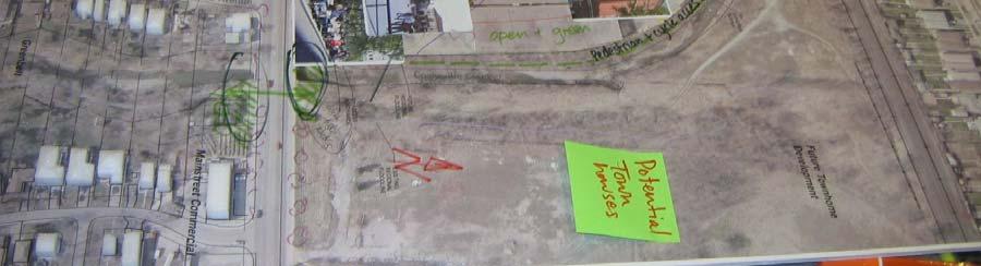
3 Page 3 of 11 Stepped heights. Mixed vertical applications. Mixed use all uses residential, commercial, office, cultural. Must be pedestrian oriented. Vibrant at night and during all seasons. Environment for everyone walking, biking. Provide rear parking cars park at a rear access, away from the water Focus on major access points e.g. Lakefront Promenade - add boulevards and bike paths Cars can t go down to the waterfront keep away from water. Disperse traffic/access points. Intensify to get transit hook up LRT to Toronto light rail; build transportation links. Group 2 Lakeshore Road Rear laneways/driveways could take pressure off traffic on Lakeshore Road. Curb cuts, exits/parking, needs to be rationalized. Reduce parking on main street. Improve realm for pedestrians pedestrian connections. Have a village look, streetscape. Mixed commercial/retail along Lakeshore Road First 2 storeys at the street, after 3 rd floor steps back. Friendly for bicycles, i.e. put in bicycle racks, be able to attach to buses, bike lanes? Lighting important. Safety needs to be designed for. Seating, benches need more opportunities. Opportunities for shade. Awnings on buildings. Dog friendly green spaces. Allow patios/retail restaurant cafes where appropriate. Opportunities in the industrial areas. Buildings need to be close to people to succeed as retail and commercial. Attract high end commercial. Access to lake both visual and physical. Intensification what about height? Higher buildings appropriate along rail road tracks? Place higher buildings away from low residential areas? Dedicated transit lanes. Group 3: Inglis Site This site was once the admiral manufacturing plant; now an industrial site Bike path exists to park south of Lakeshore. Passageway under rail line to north. There is a bicycle path that carries up along the creek and a passageway over/under the bridge to Atwater o Need to open the entrance of the bicycle path and provide day lighting Page 3 of 11
4 Page 4 of 11 o Make entrance to bike path more inviting many people don t know about it. High buildings at back of property near the tracks, that are well designed, and not taller than storeys. The three apartment buildings on Cawthra Road doesn t cause a problem [Note: this may be referencing the three apartment buildings along Caven Road and not Cawthra Road] Needs interesting facades good architecture. Provide additional access other than Lakeshore a side street connection to Cawthra Road to reduce traffic congestion. Townhouses development at front. Retail front okay but may be better to concentrate retail commercial at Cawthra Road. No more than 3 storeys on Lakeshore. Include central open space. Open green space along Cooksville Creek. Redirect water for an ice rink Region is relocating a pumping station o Site proposed is beside the creek o Like to have this located at the back of the site o Otherwise, needs well designed(?) facade No pumping station at Lakeshore. Push back so it can t be seen, or disguise it. High quality urban form along Lakeshore. o Keep larger forms at the back of the site o Build attractive townhouses o Create a central open space, a piazza Built form and uses: o Offices/employment to keep people in Lakeview. o Lakeview should have less industry because it cuts Lakeshore and neighbourhoods off from Lake. o Develop as a village traditional townhomes with more contemporary design above. o Parking behind buildings, instead of on street, office uses can share parking. o Technology park in Ottawa with green spaces. o Buildings should be transparent at the Creek, with windows and glass looking onto creek and public spaces. o Organize site and buildings to create views and access to creek, eg. Beaches in Toronto colour and variety. Streetscape and Open Space: o Tree-lined Lakeshore and open space along the Creek. o Creek as a pedestrian/bike corridor bridge over rail line it should be landscaped and naturalized and be publicly accessible. o Shuttles, express community bus to Go station. o Potential for Go train stop? Number of stops are restricted between Port Credit and Lakeview. o Transit to support density instead of density to support transit. o Local Lakeshore connection to regional line connection to Long Branch. Page 4 of 11
5 Page 5 of 11 o o o o o Buses every ½ hour, can walk faster. Create a plaza on the creek of in the centre of the site eg. Distillery District, Old Montreal. Improve entrance to the creek lighting, landscape, signage creek doesn t feel safe at night. Pumping station location needs to be carefully considered from an urban design perspective. Entrance to creek on south side welcoming sign. Group 4: Inglis Site Floodplain no development should be allowed. Lakeshore Road should be pedestrian friendly with lower building heights. Higher density and taller buildings in back. Low heights on edges. Lower density/buildings along the west side of the site gradual decrease in density. Towers adjacent to flood plain views, scale of space more appropriate. Bike path/ walk path along creek; have connections across the creek to the other neighbourhood. Front of Lakeshore should be mixed commercial/retail/office use. Buildings to have character and individuality. No cookie cutter buildings. Preserve green spaces. Area near GO Station to support higher density. Character of community is very important. Group 5 Industrial Lands Scenario 1: Assuming Employment Lands remain Group did not consider the existing condition as staying. Assumed whole site could be redeveloped. Scenario 2: Assuming the site could be significantly redeveloped Connecting Lakeshore to lake is a key element. More employment opportunities without industrial uses and allow mixed use commercial/residential. Rail station - use buffer for transit. Wide boulevard could contain LRT to Toronto, trendy rail station, lands, access to appropriate commercial/retail, park seating Connect Lakeshore to lake along Lakefront Promenade Key commercial entry point to be identified. Create hierarchy of entrance nodes. Pick up on existing street grid to the north. Secondary street storey buildings should be mixed uses. Heights need to retain charm of community. Lower portion of industrial area as entry point. Create vibrant store front, commercial centres, etc. Railway station with a bench and park Page 5 of 11
6 Page 6 of 11 Create a village square feel. Courtyards between buildings with semi-private spaces. Secondary circulation could happen away from street and be pedestrian oriented. Park transition zone at south end of site along existing parks. Group 6: Lakeshore Road 3 different pockets Cawthra Node, Industrial Lands and Arsenal Park each with a different character. 4 storeys high at the most throughout development. Sidewalk, setback and building relationship to the street frame quality of pedestrian space. First tier of buildings should be low, maximum 4 storeys in height. Lakeshore Road itself to be improved with streetscaping reflecting character of pocket. Industrial area boulevard wide enough to include mixed use development fronted by linear park that includes bike lanes and LRT line. Connect LRT to Long Branch station to the east. Industrial area should be mixed use including employment, residential and commercial. Distillery lands downtown Toronto are a good example. Parking allow for proper parking remove from main street to allow room for bike lanes - driveways parallel to Lakeshore can provide access to lots or structures and take traffic off of Lakeshore Road reduce congestion. Use Clarkson as example. Control access points, driveways and curb cuts. Promote shared entranceways on Lakeshore Road and/or encourage access points on side or back streets. Line up north south streets to better organize intersections. Train tracks on hydro lands, connect to this area; become part of LRT? Cawthra and Lakeshore Road node is good retail strip. Increase quality, variety and opportunities for shopping. Use wide colonnades and pedestrian spaces in front of buildings, stepback tall buildings up and away from street. Page 6 of 11
7 Page 7 of Illustrated Worksheets: Group 1 Lakeshore Road Group 2 Lakeshore Road Page 7 of 11
8 Page 8 of 11 Group 3 Industrial Lands Page 8 of 11
9 Page 9 of 11 Group 4 Industrial Lands Page 9 of 11


10 Page 10 of 11 Group 5 Inglis Site Group 6 Inglis Site Page 10 of 11

11 Page 11 of 11 What s next? Lakeview and Port Credit Open House Spring 2008 (Exact date and location to be determined) Page 11 of 11
Lakeview and Port Credit District Policies Review Public Engagement Process
 Lakeview and Port Credit District Policies Review Public Engagement Process Brook McIlroy Planning + Urban Design/PACE Architects MSAi Architects Poulos and Chung Transportation Engineers December 11,
Clairtrell Area Context Plan
 Clairtrell Area Context Plan March 2005 Urban Development Services City Planning Contents 1. Introduction... 4 2. Development Structure... 6 2.1 Streets... 7 2.1.1 Sheppard Avenue and Bayview Avenue...
PUBLIC MEETING April, 20161
 PUBLIC MEETING April, 20161 The Study Area Study Area Focus Area Corridor Neighbourhoods 2 Today s Presentation This material is aimed at providing viewers with enough background to be able to think about
LAKEVIEW LOCAL ADVISORY PANEL. THE COPORATION OF THE CITY OF MISSISSAUGA THURSDAY, NOVEMBER 18, 2010
 LAKEVIEW LOCAL ADVISORY PANEL THE COPORATION OF THE CITY OF MISSISSAUGA www.mississauga.ca/lakeviewportcreditreview THURSDAY, NOVEMBER 18, 2010 MISSISSAUGA SENIORS CENTRE LUCY TURNBALL ROOM (1389 Cawthra
RESEDA - WEST VAN NUYS COMMUNITY PLAN
 RESEDA - WEST VAN NUYS COMMUNITY PLAN Executive Summary As part of the initial outreach effort, the Department of City Planning hosted two workshops for the Reseda-West Van Nuys Community Plan Area during
Mark-up of the effect of the proposed Bronte Village Growth Area OPA No.18 on the text of section 24, Bronte Village, of the Livable Oakville Plan
 Mark-up of the effect of the proposed Bronte Village Growth Area OPA No.18 on the text of section 24, Bronte Village, of the Livable Oakville Plan Notes: This document is provided for information purposes
WELCOME and introduction
 1 WELCOME and introduction Mobility Hub Locations within Burlington STUDY OVERVIEW STUDY OBJECTIVES The City of Burlington is developing four Area Specific Plans, one for each of Burlington s Mobility
Derry Green Corporate Business Park
 Town of Milton Derry Green Corporate Business Park Urban Design Guidelines BMI/Pace - June 2010 Draft 3 Prepared by: Brook McIlroy Planning + Urban Design / Pace Architects Suite 300-51 Camden Street Toronto,
PUBLIC OPEN HOUSE HURONTARIO-MAIN CORRIDOR SECONDARY PLAN
 PUBLIC OPEN HOUSE HURONTARIO-MAIN CORRIDOR SECONDARY PLAN Tuesday, February 28, 2012 6pm 9pm 1 st Floor Atrium, City Hall 2 Wellington Street West, Brampton 1 POLICY FRAMEWORK The 2006 Provincial Growth
Yonge Eglinton Centre Urban Design Guidelines
 Yonge Eglinton Centre Urban Design Guidelines City Planning Urban Design January 2009 YONGE EGLINTON CENTRE INTRODUCTION.................................................... 1 GENERAL SITE PLAN OBJECTIVES......................................
Bank Street Secondary Plan
 1.1 Introduction The is a guide to the long term design and development of the portion of Bank Street between Riverside Drive and Ledbury Park, and provides direction on land use, built form, design, parking,
Shared Principles and Emerging Plan Directions
 Shared Principles and Emerging Plan Directions Introduction Since the Fairfield Neighbourhood planning process launched in June 2016, we have heard from many residents, businesses, groups and other people
appendix and street interface guidelines
 appendix five: building and street interface guidelines appendix 5 building and street interface guidelines BOULEVARDS Boulevards are generally characterized by higher levels of traffic movement at higher
PLAN ELEMENTS WORKSHOP. April 5, 2016
 PLAN ELEMENTS WORKSHOP April 5, 2016 needs more housing. But there is no one-size fits-all solution. Every neighborhood has its own character. In some places, density is not only appropriate it is badly
Queensborough Eastern Neighbourhood Node. Community Open House
 Queensborough Eastern Community Open House The Vision The Queensborough Eastern will become the heart of eastern Queensborough. Through a sensitive mix of viable commercial and residential areas, the neighbourhood
Hamilton Pier 7&8 Public Meeting and Workshop #1
 Hamilton Pier 7&8 Public Meeting and Workshop #1 May 12, 2015 May 01, 2015 Meeting Agenda 6:30 Doors Open 6:30-6:45 Review Boards 6:45-7:10 Introductions and Presentation Study Overview Policy Background
Aldershot GO Draft Mobility Hub Concepts. East Plains United Church September 13, :30 8:30 pm
 Aldershot GO Draft Mobility Hub Concepts East Plains United Church September 13, 2017 6:30 8:30 pm Today s Agenda 6:30pm: 6:35pm: 7:10pm: 8:10pm: 8:25pm: Opening Remarks Rosa Bustamante, Manager Mobility
ELMVALE ACRES SHOPPING CENTRE MASTER PLAN
 ELMVALE ACRES SHOPPING CENTRE MASTER PLAN Contents 1.0 INTRODUCTION... 2 2.0 LOCATION... 2 3.0 EXISTING CONTEXT... 2 4.0 VISION & GUIDING PRINCIPLES... 2 5.0 LAND USE AND BUILT FORM... 4 5.1 St. Laurent
5.1 Site Plan Guidelines
 5. Community Core Guidelines Development of the Community Core will take place by plan of subdivision and site plan approval. It will occur in a phased manner that will reflect the timing of residential
Arterial Mainstreets ottawa.ca
 Urban Design Guidelines for Development along Arterial Mainstreets ottawa.ca Ce document est disponible en français sur ottawa.ca. This document is available in French on ottawa.ca. Approved by City Council
Planning Board Briefing
 Planning Board Briefing Why Now? The Sector Plan Implementation Chapter States: Before Stage 1 begins, the following must occur: Approval of the Sectional Map Amendment. Approval of the Greater Lyttonsville
CITY OF VAUGHAN D R A F T YONGE STREET STUDY. June 2008 YOUNG + WRIGHT /IBI GROUP ARCHITECTS DILLON CONSULTING LTD.
 CITY OF VAUGHAN June 2008 YOUNG + WRIGHT /IBI GROUP ARCHITECTS GHK SUSTAINABILITY INTERNATIONAL + LIVABILITY (CANADA) LTD. = COMMUNITY VALUE DILLON CONSULTING LTD. Public Open House Tonight s Meeting WELCOME
lot flankage Y street 16m 6m landscape strip for large site 3m landscape strip for small medium site
 Commercial General Commercial Objectives Create developments compatible with adjacent land uses in scale, function and character Define a consistent and attractive street edge with quality landscaping,
New-Cast Mixed-use Development Proposal King Street West, Newcastle, Ontario
 URBAN DESIGN BRIEF New-Cast Mixed-use Development Proposal King Street West, Newcastle, Ontario TABLE OF CONTENTS: 1.0 Executive Summary 2.0 Creating Vibrant and Sustainable Urban Places: Excerpts from
HIGHLAND VILLAGE GREEN URBAN DESIGN PRINCIPLES/GUIDELINES
 URBAN DESIGN GUIDING PRINCIPLES/GUIDELINES CONTEXT/CHARACTER The City of Calgary s Municipal Development Plan (MDP), Transit-Oriented Development (TOD) Policy Guidelines and Main Street/Corridor policy
burlington mobility hubs study Downtown Burlington Mobility Hub
 burlington mobility hubs study Downtown Burlington Mobility Hub Draft Precinct Plan Workbook PIC #3, September 7, 2017 downtown mobility hub objectives City staff and their consultants are proposing an
THRIVE STABLE COMMUNITY V PROSPER VISION DESIGN TRUST ACTIVE DISTINCT SAFE FUTURE LANDUSE ENERGY FORM INFRASTRUCTURE STREETSCAPE URBAN MULTI-MODAL
 LE ATION PEDESTRIANS FUTURE C THRIVE SAFE PLAN INNOV IVERSE INSPIR VISION ENERGY CONSULTATION INNOVATION VIBRANT BUILDING F PROSPER DISTINCT SAFE NATURAL STREETSCAPE FORM INFRASTRUCTURE DIVERSE VIBRANT
PORT WHITBY COMMUNITY
 PORT WHITBY COMMUNITY SECONDARY PLAN UPDATE COMMUNITY IMPROVEMENT PLAN URBAN DESIGN GUIDELINES September 2015 DRAFT PROPOSED AMENDMENT NUMBER # to the Whitby Official Plan PURPOSE: The intent of this Amendment
Secondary Plan - Annexed Lands. Vision Workshop Summary March 14th 2011
 Secondary Plan - Annexed Lands Vision Workshop Summary March 14th 2011 i Table of Contents 1.0 Executive Summary 1 1.1 Priority Directions 1 1.2 A Vision for the Annexed Lands 2 2.0 Introduction 2 2.1
Agenda. 7 Wright Crescent Urban Design Study. Public Meeting and Urban Design Workshop. 1 INTRODUCTION AND BACKGROUND (City of Kingston)
") Urban Design Study Public Meeting and Urban Design Workshop October 02, 2013 Agenda 1 INTRODUCTION AND BACKGROUND (City of Kingston) 2 URBAN DESIGN STUDY PRESENTATION (Antonio Gomez-Palacio, DIALOG) 3
Urban Design Study Public Meeting and Urban Design Workshop October 02, 2013 Agenda 1 INTRODUCTION AND BACKGROUND (City of Kingston) 2 URBAN DESIGN STUDY PRESENTATION (Antonio Gomez-Palacio, DIALOG) 3
Complete Neighbourhood Guidelines Review Tool
 Complete Neighbourhood Guidelines Review Tool Prepared By: City of Regina Planning Department October 2014 Page 1 of 14 Community Development Review Checklist for Secondary Plans and Concept Plans The
Laird in Focus Community Information Session
 Laird in Focus Community Information Session Tuesday, December 5, 2017 St. Anslem Catholic School, 182 Bessborough Drive Session 1: 5:30 pm - Presentation and Question and Answer Period 6:15 pm - Breakout
Lakeview. March 18, N. Barry Lyon Consultants Ltd. UEM TMIG
 Lakeview March 18, 2014 N. Barry Lyon Consultants Ltd. UEM TMIG Mississauga s Waterfront A Coordinated Approach mississauga.ca/waterfront Mississauga s Waterfront - Projects Natural Heritage and Urban
Regency Developments. Urban Design Brief. Holyrood DC2 Rezoning
 Regency Developments Urban Design Brief Holyrood DC2 Rezoning Stantec Consulting Ltd. 7-31-2017 1. Overview Regency Developments intends to rezone the lands located at 8510 and 8511 93 Avenue, within the
DRAFT DRAFT DRAFT DRAFT
 # 19 EXPAND GREEN AND OPEN SPACES AND COMMUNITY FACILITIES IN TANDEM WITH NEW DEVELOPMENT The role of Eglinton will change in the coming years, along with the intensity of activity and land uses. As more
THE NEIGHBORHOOD TODAY
 THE NEIGHBORHOOD TODAY CORE AREA VISION How are we Good Urbanism A Site s DNA thinking about Elements of great Unique elements urban communities embedded in a place the site and design? ELEMENTS LIKE:
1.4 TRANSIT VISION 2040 FROM VISION TO ACTION THEME 1: PUTTING TRANSIT AT THE CENTRE OF COMMUNITIES. Fully integrate transit with community design
 TRANSIT VISION 2040 FROM VISION TO ACTION TRANSIT VISION 2040 defines a future in which public transit maximizes its contribution to quality of life with benefits that support a vibrant and equitable society,
GO Station Mobility Hubs: Draft Precinct Plans. Committee of the Whole July 12, 2018
 GO Station Mobility Hubs: Draft Precinct Plans Committee of the Whole July 12, 2018 Purpose of this Workshop Present Draft Precinct Plans for the 3 GO Station Mobility Hubs Continue the conversations that
This Review Is Divided Into Two Phases:
 Semiahmoo Town Centre Review The purpose of this review: To review the Semiahmoo Town Centre Concept Plan, originally approved in 1993, to ensure that this centre will continue to serve the needs of South
Status Report: MD 355 Project
 Status Report: MD 355 Project OCTOBER 2006 M-NCPPC MONTGOMERY COUNTY PLANNING DEPARTMENT Summary of Community Comments, and break to the Results of the MD 355 Participation Session Brookside Gardens -
Lower Merion Commercial Districts Issues and Characteristics Handbook November 2013
 Lower Merion Commercial Districts Issues and Characteristics Handbook November 2013 DRAFT TOWNSHIP-WIDE VISION: To maintain and enhance commercial areas to complement the surrounding high-quality residential
McCowan Precinct Plan Study Background & Deliverables
 1 DRAFT & WITHOUT PREJUDICE McCowan Precinct Plan Study Background & Deliverables In September, 2011, City Planning (Scarborough District) began a study of an area within the Scarborough Centre, identified
Lehigh Acres Land Development Regulations Community Planning Project
 Lehigh Acres Land Development Regulations Planning Effort Summary In July, 2010 Commissioner Frank Mann invited the Lehigh Acres community to start discussing how to achieve their recently adopted community
GUIDELINES WESTON LOCATION: URBAN DESIGN GUIDELINES
 Development in the Weston area will be consistent with the following urban design guidelines. The guidelines correspond to Site and Area Specific Policies 45, 46, 47, 48, 49, 51, 52 and 232 in Chapter
Urban Design Manual PLANNING AROUND RAPID TRANSIT STATIONS (PARTS) Introduction. Station Study Areas
 Introduction. Station Study Areas") 111111 PLANNING AROUND RAPID TRANSIT STATIONS (PARTS) Introduction The ION rapid transit system will link Waterloo, Kitchener and Cambridge through a central transit corridor (CTC). There are a number
111111 PLANNING AROUND RAPID TRANSIT STATIONS (PARTS) Introduction The ION rapid transit system will link Waterloo, Kitchener and Cambridge through a central transit corridor (CTC). There are a number
4.9 Mendocino Avenue Corridor Plan Design Guidelines
 4.9 Mendocino Avenue Corridor Plan Design Guidelines The Mendocino Avenue Corridor Plan addresses the area between College Avenue and Steele Lane. Mendocino Avenue is a busy arterial that runs parallel
(DC1) Direct Development Control Provision DC1 Area 4
 Direct Development Control Provision DC1 Area 4") . General Purpose (DC) Direct Development Control Provision DC Area 4 The purpose of this Provision is to provide for an area of commercial office employment and residential development in support of the
. General Purpose (DC) Direct Development Control Provision DC Area 4 The purpose of this Provision is to provide for an area of commercial office employment and residential development in support of the
GOLDEN MILE SECONDARY PLAN. Community Consultation Meeting #3 June 26, 2018
 GOLDEN MILE SECONDARY PLAN Community Consultation Meeting #3 June 26, 2018 Meeting Overview 1. Introduction 2. Principles + Vision 3. Street + Block Alternatives 4. Parks + Open Space Alternatives 5. Land
URBAN DESIGN BRIEF. 2136&2148 Trafalgar Road. Town of Oakville
 URBAN DESIGN BRIEF 2136&2148 Trafalgar Road Town of Oakville Prepared By: METROPOLITAN CONSULTING INC For 2500674 Ontario Inc November 2016 TABLE OF CONTENTS Page No. 1.0 Introduction/Description of Subject
Workshop 3. City of Burlington Waterfront Hotel Planning Study. September 14, The Planning Partnership
 Workshop 3 City of Burlington Waterfront Hotel Planning Study September 14, 2017 The Planning Partnership The Waterfront Hotel Planning Study 01 The Brant & Lakeshore Planning Study will establish a Strategic
SQUAMISH 2010 AND BEYOND COMMUNITY VISION
 Our plan has been imagined and created to be both pragmatic and visionary. At the core of the strategy is a consideration of the highway s role and its impact on the community. First and foremost in creating
New Street Proposed Redevelopment Architecture & Urban Design Brief
 2130 2136 New Street Proposed Redevelopment Architecture & Urban Design Brief Prepared By: Cynthia Zahoruk Architect Inc. 3077 New Street, Burlington, ON, L7N 1M6 TABLE OF CONTENTS Background and Objective
AGINCOURT SECONDARY PLAN
 1 AGINCOURT SECONDARY PLAN 1. AGINCOURT SECONDARY PLAN The following policies and principles apply to the area herein referred to as Agincourt, as outlined on Map 1-1. 1. GENERAL POLICIES 1.1 This Secondary
C I T Y O F T O R O N T O L A W R E N C E A V E N U E E A S T S T U D Y. Northwest Corner of Birchmount Road and Lawrence Avenue East
 C I T Y O F T O R O N T O A P P E N D I X A Northwest Corner of Birchmount Road and Lawrence Avenue East 92 DILLON CONSULTING LTD. - J.C. WILLIAMS GROUP LTD. APPENDIX B LAWRENCE AVENUE EAST STUDY SUMMARY
URBAN DESIGN BRIEF URBAN DESIGN BRIEF 721 FRANKLIN BLVD, CAMBRIDGE August 2018
 URBAN DESIGN BRIEF URBAN DESIGN BRIEF 721 FRANKLIN BLVD, CAMBRIDGE August 2018 DESIGN BRIEF CONTENTS PART A 1.0 INTRODUCTION 2.0 DESCRIPTION & ANALYSIS OF SITE CONTEXT 3.0 DESIGN CONSTRAINTS AND OPPORTUNITIES
Introduction. Intent of the Plan. Urban Design and Land Use Approach
 Introduction Intent of the Plan This is the Second Public Open House for the. The intent of the is to update current City policy in order to encourage future development that will ensure a diverse, lively,
To ensure human scale design, the towers step back from the facade of the building after four stories.
 41 40 SPRING GARDEN WEST A DESIGN BY PUBLIC ENGAGEMENT Chapter 3 Design SETBACK (SPRING GARDEN WEST LOOKING SOUTH) To ensure human scale design, the towers step back from the facade of the building after
CHAPTER 5: GUIDING PRINCIPLES
 CHAPTER 5: GUIDING PRINCIPLES The following 10 principles were developed based on public consultation, planning policy and the background analysis conducted during Phase 1. The Guiding Principles significantly
Cit of Kitchener Ur 6 an Design Manual PARTA. Desi n for _--::
 Cit of Kitchener Ur 6 an Design Manual Date PARTA Year ) Desi n for k Nodes Corridors _--:: Section Page 01 of 12 2 INTRODUCTION Purpose & Application Nodes and Corridors have been identified as key intensification
Pointe-Claire Community Destination
 Pointe-Claire Community Destination Lester John Vidal Sarah Gregoire-Caucci Gabriel Van Beverhoudt APRIL 2011 Table of Content 1. Executive Summary Problems & Solutions Current State Approach 2. Program
Burnside Gorge Neighbourhood Plan. Engagement Summary
 Burnside Gorge Neighbourhood Plan Engagement Summary Table of Contents Engagement Summary... 3 Phase One Engagement (April May 2015)... 4 Phase Two Engagement (January March 2016)... 4 Appendix One: Summary
11.5 Kipling Avenue Corridor Secondary Plan
 11.5 Kipling Avenue Corridor Secondary Plan ADOPTED BY VAUGHAN CITY COUNCIL NOT YET APPROVED BY THE ONTARIO MUNICIPAL BOARD 11.5.1 Development Principles and Objectives The following principles support
Town Center (part of the Comprehensive Plan)
") Town Center (part of the Comprehensive Plan) Mercer Island Town Center Looking North (2014) In 1994, a year-long process culminated in a set of design guidelines and code requirements for the Town Center
Town Center (part of the Comprehensive Plan) Mercer Island Town Center Looking North (2014) In 1994, a year-long process culminated in a set of design guidelines and code requirements for the Town Center
East Bayshore Road Neighbourhood
 East Bayshore Road Neighbourhood Northridge Property Management Urban Design Brief 3195 East Bayshore Road City of Owen Sound January 2016 East Bayshore Road Neighbourhood Northridge Property Management
DRAFT Northeast Quadrant of Kipling Avenue and Highway 7 DRAFT AUGUST 29, Goals Land Use. The goals of this Plan are to:
 AUGUST 29, 2017 12.15 Northeast Quadrant of Kipling Avenue and Highway 7 12.15.1 Goals 12.15.2 Land Use The goals of this Plan are to: 12.15.2.1 General Provisions: a) Ensure the development of a compact
Context Plan and Urban Design Guidelines for the lands west of Provost Drive
 Concord Park Place Context Plan and Urban Design Guidelines for the lands west of Provost Drive Amendment to the Bessarion-Leslie Context Plan October 2013 Concord Park Place Urban Design Guidelines The
Imagining Ward 3 Session #2. April 18, :00 pm 8:30 pm
 Imagining Ward 3 Session #2 April 18, 2016 7:00 pm 8:30 pm Project Team City of Mississauga Karen Crouse, Project Leader, Policy Planning Division Frank Marzo, Planner, Policy Planning Division Brook McIlroy
Welcome. Walk Around. Talk to Us. Write Down Your Comments
 Welcome This is an information meeting introducing the applications for proposed redevelopment of the Yorkdale Shopping Centre site at 3401 Dufferin Street and 1 Yorkdale Road over the next 20+ years,
DRAFT. 10% Common Open Space
 % OF CHARLOTTE IS CATEGORIZED AS A. LAND USES : Placeholder map displaying location of Place Type GOALS: Accommodate XX% of future growth. Provide a concentration of primarily commercial and civic activity
QUEEN-RIVER SECONDARY PLAN
 34 QUEEN-RIVER SECONDARY PLAN 34. QUEEN RIVER SECONDARY PLAN 1. INTRODUCTION The Queen-River area is approximately 6.4 hectares and is located at the eastern edge of the Downtown as shown on Map 34-1.
Metrogate Agincourt Redevelopment
 Toronto Urban Design Guidelines Metrogate Agincourt Redevelopment City Planning Urban Design September 2008 METROGATE AGINCOURT REDEVELOPMENT TABLE OF CONTENTS 1.0 INTRODUCTION......................................................
Complete Street and the EA Process. Queen Street Corridor- Brampton Golden Mile
 Complete Street and the EA Process. Queen Street Corridor- Brampton Golden Mile Contents A. Vision B. Overview of Existing Conditions C. Queen Street Complete Street Criteria D. A quick look at the Queen
4.0 Design Guidelines For The Village Centre. South fields Community Architectural Design Guidelines Town of Caledon
 4.0 Design Guidelines For The Village Centre 4.0 Design Guidelines for the Village Centre The Village Centre is the focal point of the entire South Fields Community and is designed as a traditional commercial
1071 King Street West Zoning Amendment Application - Preliminary Report
 STAFF REPORT ACTION REQUIRED 1071 King Street West Zoning Amendment Application - Preliminary Report Date: August 9, 2012 To: From: Wards: Reference Number: Toronto and East York Community Council Director,
1354 CARLING AVENUE FORMAL RESUBMISSION HOLLOWAY LODGING
 1354 CARLING AVENUE FORMAL RESUBMISSION HOLLOWAY LODGING DECEMBER, 2017 THE SITE 1354 CARLING AVENUE The subject property is at a key gateway to the Carlington Neighbourhood, and when combined with future
Edward R. Sajecki Commissioner of Planning and Building. SUBJECT: Draft Lakeview Local Area Plan (January 2014)
") Corporate Report Clerk s Files Originator s Files CD.03.LAK DATE: TO: FROM: Chair and Members of Planning and Development Committee Meeting Date: February 3, 2014 Edward R. Sajecki Commissioner of Planning
Corporate Report Clerk s Files Originator s Files CD.03.LAK DATE: TO: FROM: Chair and Members of Planning and Development Committee Meeting Date: February 3, 2014 Edward R. Sajecki Commissioner of Planning
Welcome. Community Consultation Meeting November 28, Review and discuss the Bathurst Quay Neighbourhood Plan Framework
 Welcome Community Consultation Meeting November 28, 2016 Why Are We Here Today? Review and discuss the Bathurst Quay Neighbourhood Plan Framework Review and discuss an Action Plan for Implementation Next
Wide asphalt driveway abutting school property. garage built with incompatible materials, too close to park. incompatible fencing materials
 Wide asphalt driveway abutting school property incompatible fencing materials garage built with incompatible materials, too close to park Lack of plantings as a buffer between private property and open
TOWN COUNCIL / PLANNING COMMISSION
 Workshop #3 TOWN COUNCIL / PLANNING COMMISSION January 20, 2011 Consultant Team In Attendance Tonight BMS Design Group Nevada City and San Francisco Michael Smiley, AICP, ASLA Partner-in-Charge Nancy L.
Executive Summary. NY 7 / NY 2 Corridor
 Executive Summary NY 7 / NY 2 Corridor Transportation and Land Use Study December 2005 Prepared for: Town of Colonie Capital District Transportation Committee Prepared by: Introduction: Land use decisions
4 Study Findings. Port Credit District. Port Credit District
 4 Study Findings Section 4 Study Findings: Port Credit contains the district vision statement, a summary of public input (including stakeholder input) and a series of recommendations for public policies
Urban Design Brief to 1557 Gordon Street & 34 Lowes Road West
 Urban Design Brief 1533 to 1557 Gordon Street & 34 Lowes Road West Reid s Heritage Homes Ltd. & 883928 Ontario Ltd. and RHH Property Management Ltd. City of Guelph Zoning By-law Amendment November 2017
Urban Design Brief. Watson Parkway North & Watson Road North Guelph, Ontario. Prepared by Coletara Development
 Urban Design Brief Watson Parkway North & Watson Road North Guelph, Ontario Prepared by Coletara Development December, 2013 Urban Design Brief, Coletara Development 1 Introduction This Urban Design Brief
Further input invited as Colchester Growth Strategy nears final phase
 IUE 3 / NOVEMBER 2015 Further input invited as Colchester Growth trategy nears final phase trathcona County is seeking public feedback as it enters the final phase of work on a Growth Management trategy
URBAN DESIGN BRIEF. Terms of Reference. Purpose. When is an Urban Design Brief Required
 Purpose An Urban Design Brief (UDB) is intended to describe and illustrate proposed designs for new development projects and demonstrate how the City s Urban Design Guidelines and other City policies have
VILLAGE OF SKOKIE Design Guidelines for Mixed-Use Districts NX Neighborhood Mixed-Use TX Transit Mixed-Use CX Core Mixed-Use
 VILLAGE OF SKOKIE Design Guidelines for Mixed-Use Districts NX Neighborhood Mixed-Use TX Transit Mixed-Use CX Core Mixed-Use TABLE OF CONTENTS CHAPTER 1 SITE DESIGN Purpose 1 CHAPTER 2 SITE DESIGN Streetscape
TALL BUILDING GUIDELINES
 TALL BUILDING GUIDELINES Urban Design Guidance for the Site Planning and Design of Tall Buildings in Milton May, 2018 A Place of Possibility Contents 1.0 INTRODUCTION 1 1.1 What is a Tall Building? 2
Urban Design Guidelines for Large-Format Retail
 Urban Design Guidelines for Large-Format Retail May 2006 Compte tenu de la nature de ce document, il n'est disponible qu'en anglais. La Ville pourra, sur demande, traduire ce document au complet ou en
*** DRAFT 2 FOR PUBLIC REVIEW ***
 6.7 The area is generally bounded by the Red Hill Valley Parkway to the west, Lake Avenue to the east, the Queen Elizabeth Way (QEW) to the north, and by the properties just south of Queenston Road to
Community Design Guidelines. Port Wallace DRAFT
 Community Design Guidelines Port Wallace DRAFT Energy 1 2 3 Nature Movement Connections Built Form DRAFT Layout Energy 1 Nature Community Design Guidelines GREAT COMMUNITIES PROTECT, CELEBRATE, AND CONSERVE
Highland Village Green Design Guidelines
 Highland Village Green Design Guidelines Publishing Information Title Highland Village Green Design Guidelins Author The City of Calgary Status DRAFT - Proposed document subject to changes Additional Copies
Phase I Redevelopment Plan. First Community Meeting
 Hoboken Terminal and Yard Phase I Redevelopment Plan First Community Meeting May 31, 2011 One Hudson Place Phase I Redevelopment Plan Redevelopment Plan First Community Meeting Agenda 1. Redevelopment
FUTURE LAND USE ELEMENT
 FUTURE LAND USE ELEMENT GOAL I: To create and sustain a great place to live, play, and prosper Objective 1: The City of Ocala shall incorporate the principles and strategies of the Ocala 2035 Vision into
Port Credit Local Advisory Panel October 20 th Meeting
 Port Credit Local Advisory Panel October 20 th Meeting Focus Of This Evening s Meeting: 1. Hurontario Main Street Higher Order Transit Study 2. Port Credit Mobility Hub & GO Station Parking Structure Study
Urban Design Guidelines for Development along Arterial Mainstreets May 2006
 Urban Design Guidelines for Development along Arterial Mainstreets May 2006 Compte tenu de la nature de ce document, il n'est disponible qu'en anglais. La Ville pourra, sur demande, traduire ce document
Uptown Rideau Street Secondary Plan [Amendment #166, January 12, 2016]
![Uptown Rideau Street Secondary Plan [Amendment #166, January 12, 2016]](/thumbs/76/73760497.jpg "Uptown Rideau Street Secondary Plan [Amendment #166, January 12, 2016]") [Amendment #166, January 12, 2016] The policies of this Secondary Plan are in effect, save and except for the property at 560 Rideau Street, for which there remains a site specific appeal to this Secondary
[Amendment #166, January 12, 2016] The policies of this Secondary Plan are in effect, save and except for the property at 560 Rideau Street, for which there remains a site specific appeal to this Secondary
ROBBINSDALE LRT STATION CDI DEVELOPMENT GUIDELINES
 August 2018 OVERVIEW The City of Robbinsdale has a prime-opportunity site in the middle of the 13 mile stretch of the Bottineau LRT corridor / Blue Line extension. Robbinsdale offers a prominent, vital,
The Humber Bay Shores. Urban Design Guidelines Update and Public Realm Plan. January, 2008
 The Humber Bay Shores Urban Design Guidelines Update and Public Realm Plan January, 2008 prepared by Brook McIlroy Planning and Urban Design / Pace Architects Content i EXECUTIVE SUMMARY KEY RECOMMENDATIONS
Trafalgar Road Corridor Planning Study Open House
 Trafalgar Road Corridor Planning Study Open House June 24, 2013 6:30-8:30 p.m. Oakville & Trafalgar Rooms Overview The Livable Oakville Plan identifies the lands along Trafalgar Road, between the QEW and
PUBLIC RIGHT-OF-WAY IN THIS CHAPTER PUBLIC REALM
 PUBLIC RIGHT-OF-WAY This section provides design guidelines for improvements in the public right-of-way. The public right-of-way refers to streets, sidewalks, non-vehicular thoroughfares, parks and greenways