Chisholm Community Form
|
|
|
- Molly Ellis
- 5 years ago
- Views:
Transcription

1 Chisholm Community Form 1.1
2 Community Goals 1.3 Information and Assessment Recommendations Implementation
3 Community Goals Neighborhoods Strengthen the sense of community in all neighborhoods. Provide clean, safe, attractive homes and neighborhoods. Achieve a balance of single-family homes, 2-4 family homes and multi-family apartments within the city for all groups and income levels. Note: Neighborhoods and Housing are covered in detail in Chapter 6. To continue to grow and develop community life by recognizing that every design and development decision will improve the economic, social and environmental vitality of the community in a sustainable manner. Downtown Strengthen the character and economic vitality of downtown by capitalizing on existing human and physical resources. Highway 169 Corridor Retain the mixed-use character of Highway 169 in Chisholm and to improve the corridor by addressing its scenic qualities and identifying potential new entries into the Ironworld/County Fair grounds area. Highway 73 Corridor Retain the mixed-use character of Highway 73 through the City of Chisholm and to improve the corridor by addressing character and business potentials along the route. Community Entries Develop a mixed-use plan which proposes a new community entry from Highway 169, providing a mix of housing types and creating a new focus for downtown at Longyear Lake. Relationship with Balkan Township Develop and enhance the existing working relationship between Balkan Township and the City of Chisholm regarding future land use decisions and recreational opportunities. Note: At the request of Balkan Township, no additional Township planning was conducted or discussed beyond potential industrial uses adjacent to the Highway 169 corridor. 1.3
4 1.4
5 Information and Assessment The urban form of Chisholm is similar to that of many traditional outstate communities. A downtown core is surrounded by supporting neighborhoods and a linking highway that used to pass through on Main Street now bypasses to the south of the city. The scale of downtown is primarily 2 story with the surrounding residential areas at 1 to 2 stories. Introduction The City of Chisholm is completely surrounded by either the City of Hibbing to the south, or Balkan Township to the east, north and west. For some time there has been a working relationship between Chisholm and Balkan Township on matters of annexation and cooperative development. This partnership has served both communities well and should be looked at as the model for further cooperation with the other Central Iron Range communities. During the last twenty years there have been fundamental additions and alterations to Chisholm s community form. They are as follows: The rerouting of the Hwy 169 corridor, which now bypasses the city. Aging residential neighborhoods. Ironworld and the County Fair as regional recreational attractions. Loss of downtown businesses. There are two major defining factors which will continue to influence the growth and development of the city into the future are: The desire to reserve mining lands for the future to the east and west of the city. The working relationship with Balkan Township, which surrounds the city and limits growth options. The major challenges for the City are: The need to stimulate investment to revitalize particular neighborhoods. Developing strategies to keep downtown vital. Guiding development to reinforce desired physical patterns. The following information first presents an overview of planning guidelines and considerations. Second is a narrative overview of the major planning issues as raised by the community during the planning process. Third are case example studies for these planning areas which present desired attributes and outline potential opportunities and strategies. Fourth is an implementation framework for further discussion and engagement by the community. 1.5
6
7
8
9
10
11
12
13
14 Sustainable Community Planning Sustainable Overview For Chisholm and the Central Iron Range, sustainability is an economic, environmental and social issue. For years the impact and effects of iron ore mining have demonstrated the frailties of an extraction based economy. In an effort to diversify its economic base and to retain the community s social characteristics, Chisholm has had to develop a variety of partnerships with its neighbors. These partnerships have served Chisholm reasonably well; to name a few, managed growth and annexation in cooperation with Balkan Township, joint economic development planning with the City of Hibbing, and leading discussions with surrounding communities regarding a larger Central Iron Range Initiative. In moving the Comprehensive Plan forward, there are two primary overlapping concepts to guide community decision-making and economic development. The first is that every design and development decision will improve the economic, social and environmental vitality of the community in a sustainable manner. The second is that each of the basic community building blocks (land use and built form, movement networks, parks/recreation/open space, and environmental context/natural systems) together represent an integrated approach to community development. Principles for Sustainable Development 1. Strengthen the existing regional connections by defining them as pedestrian and transportation oriented corridors. 2. Align new development with existing infrastructure such as utilities and roads. 3. Reclaim abandoned mining lands for new industrial or recreational uses. 4. Reuse, redevelop previously developed commercial/industrial buildings and sites. 5. Increase density of currently developed portions of the City with a focus on life-cycle housing. 6. Develop new land and infrastructure only when land use and new economic opportunities dictate. 1.6

 the ability to reuse abandoned mining lands, and 3.) a redefinition of the connections between downtown, Highway 169 and Ironworld.")


15 The is organized around the physical framework of the sub-region. The four components of this framework, briefly described below, reflect the nature, appropriateness and priorities of development in the City of Chisholm. Land Use and Built Form 1.) Future development in Chisholm will be guided by restrictions of future mining considerations, 2.) the ability to reuse abandoned mining lands, and 3.) a redefinition of the connections between downtown, Highway 169 and Ironworld. Strengthen the development connections along the Highway 169 corridor. Continue to develop an inter-connected network of green spaces. Continue to develop a clear identity for downtown and redevelopment strategies for the neighborhoods. Movement Networks Shifting the emphasis of the regional transportation system from providing maximum vehicular capacity to the overall quality of travel by all modes will address the City s desire to encourage movement into the city. Redevelop the Highway 169 corridor into an urbanized corridor within the city and a scenic corridor between Chisholm and Hibbing. Improve the Highway 73 corridor north to Balkan Township as a community entry point. Parks, Recreation and Open Space Development of an inter-connected network of green spaces, parks and natural corridors along with high quality public facilities will contribute to a coherent network of public place and stimulate private investment. Develop additional connections to the Mesabi Trail. Develop new trails between Chisholm and the City of Buhl. Provide additional trail connections within the City of Chisholm. Develop additional trail connections from the Mesabi Trail to the Highway 5/Side Lake Recreational Area. Environmental Context/Natural Systems Encourage future development efforts that work with natural systems to guide development patterns and redress imbalances that may currently exist between the natural and built environments. Make needed improvements to the health of Longyear Lake. Plan future development east of the city to maximize the recreational potential of the abandoned mining lands and pits. 1 3 City Building Components 2 1.7


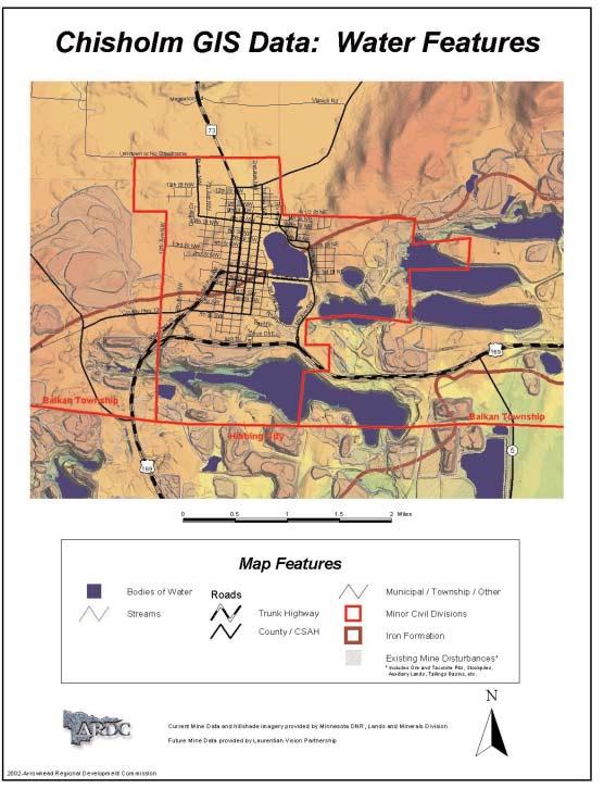
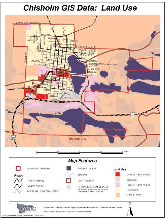
16 Planning Considerations Environmental Features The map indicates natural features. Planning Considerations: areas of active and abandoned mining lands restrictions of wet soils, retention of natural systems. Key: Coniferous Forest Deciduous Forest Mixed wood Forest Open Water Wetlands - Bogs Wetlands - Marsh/Fens Land Use/Land Cover The map indicates the existing uses on the land. Planning Considerations: areas of opportunity for new development; adjacent land uses, opportunities to connect open space systems, protection of natural systems and features. Key: Commercial Industrial Public/Parks/Open Residential Mining/Other 1.8


17 Future Mining Considerations The map indicates future mining potential as mapped by the Department of Natural Resources. Planning Considerations: That new development and community planning may not preclude long-term mining activities. Key: Current to 20 years years 50+ years Primary Auxiliary Land Composite of Existing Conditions When the previous information is applied in layers, patterns emerge which indicate areas of greater or lesser development constraints. This information is then combined with the Central Iron Range Initiative planning and the City Building Components to develop the Comprehensive Plan. Key: Bodies of Water Existing Mine Disturbances Better Development Suitability 1.9


18 Entry sequence east of Chisholm Entry sequence east of Chisholm Downtown Downtown is defined as the central business district bounded approximately one block either side of Lake Street. The historic character of downtown is the unique opportunity. While there have been many unsympathic remodels to the storefronts, this work is mainly cosmetic and has done limited structural damage. In addition, new paving, infrastructure improvements and streetscape initiatives have transformed the look and feel of Lake Street. The road to downtown vitality faces these several challenges: Securing a regional role. Attracting a diversified business base which builds upon recent improvements. A commitment that downtown is the commercial/retail center for the community. The future for downtown lie in its abilities to project itself as an historic mining town, to better connect with and integrate into its structure Ironworld and the related resources, and the creative use of mining lands at its borders. Highway 169 Corridor The Highway 169 corridor was relocated at the edge of town during the 1980 s creating a bypass around Chisholm. Over the years some business and industrial development has migrated out to the highway corridor but has not competed with the traditional downtown commercial area. This highway corridor has these two individual segments: South of Chisholm from the intersection of County Road 5 west to the intersection of Highway 73. South of the intersection of Highway 73 to Howard Street in Hibbing, (this section is covered as part of the Central Iron Range Initiative document.). There are now two significant tourist and public-use facilities on Highway 169 immediately South of an adjacent to be corridor. Ironworld is a regional mining history and interpretive complex, and recently the County Fair has relocated their site just to the east of the Ironworld facility. Highway 169 has now become the front door for Chisholm - its first image for the visitor. It is important to develop a safe and attractive roadway, that reflects the character of Chisholm and provides safe access to Ironworld and fairgrounds. A new entry into downtown would also enhance the character of Highway

19 Highway 73 Corridor The Highway 73 corridor is a major north and south route connecting to Balkan Township and regional recreational areas north of the City of Chisholm. Over the years commercial development has migrated to the highway corridor and has affected not only the viability of the traditional downtown commercial area but has created a second main street for the community. This highway corridor has these two individual segments: An urbanized section through the City of Chisholm, from Hwy 169 to Lake Street. A residential section through the neighborhoods to Balkan Township. The desire is to retain the mixed-use nature of the corridor and to develop a future general business and community entry at the north end as the transition into Balkan Township. Commercial development should be limited to convenience commercial which does not conflict with strengthening downtown commercial. New Development Opportunities During discussions and workshops, several issues have emerged regarding various physical improvements the City is contemplating. The following scenario is explored as a case study to demonstrate a larger opportunity. The items that were discussed include: Exploring redevelopment opportunities at the east end of downtown, near Longyear Lake. The disposition of vacant and under-utilized land between the school and Longyear Lake. Creating a Mesabi Trail connection into downtown. A desire to develop a general business district where the industrial park now exists. The desire to create a new entry into downtown from Highway 169. The need to develop a new and safer entry into the Ironworld and County Fair grounds site. New entry redevelopment potential When taken together they represent a major improvement opportunity for the City of Chisholm. 1.11

20 Downtown Example Characteristics Historic nature Updated streetscape Wide sidewalks Mix of businesses Assets An identifiable urba core defined by building type and pedestrian amenities A comfortable community scale and historic character Center of civic activities Downtown view and links to Longyear Lake Challenges Keeping downtown a vital center for the community Clearly defining the downtown role in the city and sub-region Recruiting businesses which will reinforce the mixed-use character Desired Downtown Attributes Image and Character Revitalized historic downtown anchored at each end by Memorial Park and Longyear Lake. Revitalization of Longyear Lake as recreational opportunity and community focal point, creating a major downtown amenity. Renewal and expansion of Memorial Park for festivals and tournaments. Access and Connections Compact and walkable downtown. Designated, all-season pedestrian routes from the neighborhoods, linking neighborhood amenities (parks, schools, open space) into downtown. Dedicated bike lanes from Memorial Park through downtown to Longyear Lake and the Mesabi Trail. Develop community gateways. Land Use and Development Focus on revitalization of existing commercial storefronts. Senior housing adjacent to downtown supports social/cultural interaction and supports downtown business. Encourage mixed-use development. Public Infrastructure Downtown remains the center for public services. Improved sidewalks and streets adjacent to downtown. 1.12


21 Recommendations/Guidelines Boulevard development north to Balkan Township Redevelop interface between Longyear Lake and downtown Historic downtown West gateway Infill development Boulevard development south to Chisholm High School Boulevard development out to Hwy 169 Opportunities/Strategies Image and Character Remodel commercial storefronts back to historic character. Strengthen east and west gateways into downtown. Extend downtown development to embrace Longyear Lake. Access and Connections Provide stronger connections to the parks. Explore the opportunity for bicycle routes from downtown to parks and the Mesabi Trail. Land Use and Development Adaptive re-use of existing vacant/underutilized buildings. Evaluate existing housing stock in terms of reinvestment and redevelopment. Develop strategies for adaptive re-use of existing commercial buildings. Look for infill housing opportunities adjacent to downtown. Public Infrastructure Develop a 5 year capital improvement program for sidewalk repair and replacement on designated streets into the neighborhoods. Remove treatment plant from Longyear Lake. 1.13

22 Highway 169 Example Western gateway Eastern gateway Ironworld County Fair grounds Business Existing Light Industrial Characteristics No community impression Limited highway oriented development. Views of man-made and natural landscapes. Assets This corridor presents the first impression of the community s image. Plenty of room for improvement. Challenges Improving the visual image of the corridor. Developing the highway corridor in a way which better integrates the public attractions of Ironworld and County Fair grounds with the City of Chisholm. Desired Highway 169 Corridor Attributes Image and Character East and west community gateways that announce an enhanced highway corridor section. An interesting and inviting entry into the city and the Ironworld/ County Fair complex. Additional landscape elements that build upon the geological context. Access and Connections Create a new entry point that establishes links to downtown and neighborhoods from Ironworld and fairgrounds. Improved trail connections to the Mesabi Trail. Land Use and Development Potential for new mixed-use neighborhood which connects downtown to Ironworld and fairgrounds. Relocated highway-oriented industrial uses further east on Hwy 169. Public Infrastructure Development of an urban highway section (curb and gutter, pedestrian lighting, sidewalks). Develop low-impact storm water run-off. 1.14


23 Ironman site urbanized highway section new mixed-use community entry and connection to Ironworld and fairgrounds Bruce Headframe Opportunities/Strategies Image and Character Designate two areas as the gateway into the community, possibly Bruce Headframe site and elaborate on the Ironman site. Develop a long-term plan and implementation strategy for new community entry and relocated entry into Ironworld/Fairground site. Access and Connections Longyear Lake trail as hub of a larger system. Develop improved links to Mesabi Trail and Longyear Lake. Link to Balkan Township. Land Use and Development Relocate existing industrial uses, rezone for mixed-use development. Develop plan for highway-oriented industrial uses in conjunction with Balkan Township. Public Infrastructure Establish timeline and funding sources for corridor improvements. An urbanized Highway 169 corridor section with curb and gutter, sidewalks and lighting. 1.15

24 Highway 73 Example Corridor Elements North entry from Balkan Township Residential district Downtown segment Mixed-use commercial South community entry Characteristics Residential feel in the northern section. Commercial orientation south of Lake Street. Assets A major through-way and link to Balkan Township. A significant community entry from the south. Challenges Development of the corridor through the residential neighborhood. Desired Highway 73 Corridor Attributes Image and Character A walkable corridor with an attractive public realm. Safe corridor crossing (calm traffic, well lighted). Access and Connections Enhance a network of movement systems. Provide non-motorized routes. Established links to parks and trails. Create a community gateway at the each end of the corridor. Land Use and Development Develop neighborhood convenience commercial at the corridors north end, next to Balkan Township. Define and create integral green spaces. Public Infrastructure Develop an urban roadway section (curb and gutter, pedestrian lighting, sidewalks). 1.16


25 Create a northern gateway into the community Create an enhanced community corridor Create a bicycle/pedestrian corridor from parks to Longyear Lake Opportunities/Strategies Image and Character Designate this area as the northern gateway into the community. Look for demonstration project opportunities. Access and Connections Designate a hierarchy for streets and movement patterns. Connect this area to the existing community. Explore the opportunity for bicycle and pedestrian routes to the Mesabi Trail. Land Use and Development Develop land uses which support the intended image and character. Develop around natural features. Public Infrastructure Develop low-impact storm water run-off. Create a southern gateway into the community 1.17

26 New Development Example Opportunities Downtown redevelopment properties Vacant and underutilized land School site Lake and trail access Desire to develop as general business area New entry into downtown Potential new access to Ironworld and County Fair grounds Characteristics Light industrial image. Vacant and underutilized land. Assets Opportunity to accomplish several discussed goals which together can have significant community impact. Many sites are currently available. Challenges Significant grade separation into the Ironworld/County Fair site. Relocation of existing businesses. Desired New Development Attributes Image and Character Provide a new image entry into Chisholm Provide a walkable corridor (good sidewalks, routes to other businesses) Develop safe highway crossing (calm traffic, well lit) Create an attractive public realm (urban forest, lighting) Access and Connections Provide a direct connection from downtown to Ironworld and County Fair grounds Improved links to Longyear Lake, parks and Mesabi Trail Land Use and Development Re-use of underutilized urban land Urban housing pattern (sidewalks, alleys, etc.) Internal green spaces Public Infrastructure Reuse of existing infrastructure 1.18
27 Boulevard connection into downtown Park Commercial development Longyear Lake Ironworld/ Fairgrounds Highway 169 New housing Extended Mesabi Trail and Lakewalk The New Development could address several related issues being discussed in the community. Combine the new City entry with a new Ironworld/County Fairgrounds entry, develop the new entry with a park and related businesses, connect the town entry to the lake, provide a new entry into downtown, and re-develop adjacent underutilized properties for housing, and new commercial development at the end of downtown, next to the lake. Opportunities/Strategies Image and Character Develop a new entry for Chisholm and Ironworld/County Fair Develop a town center with a park and highway oriented businesses Access and Connections Create a new entry into downtown. Develop the lake walk and connect to a Mesabi Trail connection Land Use and Development Redevelop adjacent underutilized sites for housing Develop around natural features Public Infrastructure Maximize use of existing infrastructure 1.19
28 Downtown Goal: To strengthen the character and economic vitality of downtown by capitalizing on existing human and physical resources. Actions 1. Create a shared vision for downtown among all major stakeholders, including business owners and the city. 2. Keep downtown the center of social and cultural activities. 3. Maintain and enhance the character and human scale of downtown streets and historic architecture. 4. Enhance economic viability and public interest in the downtown district through strategic reinvestment. 5. Coordinate city programs, agency capabilities and private initiative to facilitate and support downtown redevelopment. Highway 169 Corridor Goal: To retain the mixed-use character of Highway 169 in Chisholm and to improve the corridor by addressing its scenic qualities and identifying potential new entries into the Ironworld/County Fair grounds area. Actions 1. Enhance the human scale of the corridor with landscaping, lighting and improved crossings for pedestrian and bicycles 2. As necessary, modify existing zoning regulations, spot zoning and other city ordinances to maintain the integrity of the corridor and prevent incompatible uses. 3. Seek redevelopment opportunities to relocate conflicting land uses. 1.20
29 Highway 73 Corridor Goal: To retain the mixed-use character of Highway 73 through the City of Chisholm and to improve the corridor by addressing character and business potentials along the route. Actions 1. Enhance the human scale of the corridor with landscaping, lighting and improved crossings for pedestrian and bicycles. 2. As necessary, modify existing zoning regulations, spot zoning and other city ordinances to maintain the integrity of the corridor and prevent incompatible uses. 3. Seek redevelopment opportunities to relocate conflicting land uses. New Development by the Lake Goal: To develop a mixed-use plan which proposes a new community entry from Highway 169, providing a mix of housing types and creating a new focus for downtown at Longyear Lake. Actions 1. Develop a community based approach to future land use planning. 2. As necessary, modify existing zoning regulations, spot zoning and other city ordinances to maintain the integrity of the corridor and prevent incompatible uses. 3. Seek redevelopment opportunities to relocate conflicting land uses, possibly east along the Highway 169 corridor. 1.21
30 Relationship with Balkan Township Goal: To develop and enhance the existing working relationship between Balkan Township and the City of Chisholm regarding future land use decisions and recreational opportunities. Actions 1. Pursue joint development decisions which are mutually beneficial to both parties. 2. Explore opportunities to expand recreational connections. 1.22


31 Conceptual Community Development Downtown and the surrounding neighborhoods remain the urbanized core, with the Highway 169 corridor redeveloped to connect Ironworld and its dynamic landscape with the City fabric Cultural Resources A comprehensive and inter-connected cultural resource platform in Chisholm supports the larger social/cultural objectives of the Central Iron Range Initiative. Neighborhoods/housing Create a Master Plan for neighborhoods and housing. Strengthen neighborhood identity, preserve existing neighborhoods, ensure availability of affordable housing options. Future mining potential Future housing New commercial development Future housing Chisholm to Buhl Area recreation and residential Economic Development The following projects represent an agreed upon development direction for the Central Iron Range Initiative within the City of Chisholm. Corridor Development Highway 169 Development; Redevelopment of this corridor which enhances Chisholm s presence between the two city entries Hibbing - Chisholm Corridor; Development; A scenic corridor with selected development opportunities. Highway 73 Development; Improvements to this corridor which support additional commercial development and improved community entry. Parks/Open Space Develop a mixed-use open space / recreation corridor between Chisholm and Buhl, develop improved trail connections to the Mesabi Trail, develop trail connections to County Road 5/Side Lake and interconnect trails/parks throughout Chisholm. Land Use Strengthen land use definitions and consistent application to support the Comprehensive Plan objectives. Redeveloped highway section Expanded trail and open space system Chisholm to Buhl Area Recreational and Residential Development; At the edge of water filled abandoned mining pits, the building sites will offer spectacular vistas and access to recreation and fishing. Infrastructure Development Central Range Utility District - Sewer and Water; Address wastewater treatment infrastructure needs and initiatives that surrounding communities cannot solve independently. Industrial Development Highway 169 Development; Highway related industrial development east of Chisholm. 1.23
32 1.24
33 Implementation General Recommendations 1. The city should convene a round table, coordinating municipal departments, non-profits and private concerns to focus on downtown issues and programs. The round table would provide a forum to strengthen communication and foster partnerships between the public and private sectors operating in downtown with the purpose of enhancing the district s appeal to businesses, shoppers, tourists and residents. Those in leadership roles should meet on a regular basis, perhaps quarterly, to share information, air concerns and, when appropriate, pool resources for cooperative efforts. Downtown Convene discussion round tables Schedule downtown events Establish downtown districts Promote historic nature 2. Use downtown events as a springboard for revitalization. Major downtown events have been successful in attracting large numbers of people and have the potential to enhance perceptions of the community both locally and regionally. Along with public relations benefits, festivals bring economic advantages and enjoyment. The downtown needs more frequent programmed events to ensure that existing businesses and institutions benefit from the visitation they bring. 3. Establish districts within the downtown area which have distinct identities and complement each other. The downtown across the nation have demonstrated that segmenting downtown into a series of smaller components has enhanced revitalization efforts. The smaller areas allow for more specific targeting of resources and programs, and make results more visible. 4. Protect, promote and capitalize on the appeal of the the downtown historic architecture. The the downtown historic architecture has been cited as one of the area s strengths and attractions and should be incorporated into redevelopment initiatives. 1.25
34 Recommendations for Physical Improvements Create a downtown signage program. Support gateway improvements. Plant and maintain trees throughout downtown. Establish a Business Improvement District. Identify opportunities to support mixed-use redevelopment. Establish a comprehensive Facade Improvement program for downtown. 5. Create a downtown signage program. Informational signage is recommended to help visitors find their way to the area s various facilities and attractions, and to promote fuller use of the area by promoting services and destinations. Such a system should be integrated into the urban context using kiosks, map systems, etc. 6. Support gateway improvements. The appearance of major roads leading into the downtown is a source of major concern, as it is widely perceived as a deterrent to downtown visitation. 7. Plant and maintain trees throughout downtown. Streets lined with trees bring a more intimate scale to urban areas, creating a warmer and more comfortable sense of place for pedestrians. Trees also help to enclose and define streets that have parking lots and few buildings, again enhancing the experience of walking. 8. Establish a Business Improvement District. A downtown BID provides the resources and mechanisms to help manage the public environment, attract and retain businesses and assist with marketing, sanitation and other centralized services. A well-supported BID results in a better managed and programmed downtown, and would have a positive impact on the overall perceptions of the community. 9. Identify opportunities to support mixed-use redevelopment. This strategy might include renovation of vacant or underutilized upper floors of downtown buildings to create affordable housing and increase the residential base of downtown. 10. Establish a comprehensive facade improvement program for downtown. A typical program provides matching monies or grants for restoration/renovation of facades with ground floor commercial uses. These programs are available to property owners and leaseholders. 1.26
35 General Recommendations 1. Begin discussions with Minnesota Department of Transportation and the County regarding issues of traffic management and community image. 2. Establish a community-based Task Force. This Task Force should be led by the Planning Commission and include representatives of MnDOT, th County, the City, retail business owners, land owners and residents. This should be an anticipatory process, not reactive. The goal of the Task Force is to develop a set of guiding principles for the corridor. This should include guidelines for lot development, traffic management, landscape, pedestrian amenities and connections to the existing open space systems. The process should also outline other requirements for development. Highway 169 Corridor Begin discussions with Minnesota Department of Transportation and the County. Establish a community-based Task Force. Develop a master plan for land use in the corridor. 3. Develop a master plan for land use in the corridor. With guiding principles and guidelines in hand, a master plan and development schedule should be assembled. 4. Engage a public artist and landscape architect to develop conceptual designs for the community gateways. General Recommendations 1. Establish a community-based Task Force. This Task Force should be led by the Planning Commission and include representatives of MnDOT, the County, the City, retail business owners, land owners and residents. This should be an anticipatory process, not reactive. The goal of the Task Force is to develop a set of guiding principles for the corridor. This should include guidelines for lot development, traffic management, landscape, pedestrian amenities and connections to the existing open space systems. The process should also outline other requirements for development. Highway 73 Corridor Begin discussions with Minnesota Department of Transportation and the County. Establish a community-based Task Force. Develop a master plan for land use in the corridor. 1.27
36 2. Develop a master plan for land use in the corridor. With guiding principles and guidelines in hand, a master plan and development schedule should be assembled. 3. Engage a public artist and landscape architect to develop conceptual designs for the community gateways. New Development/ Community Entry Establish a community-based Task Force. Develop a Master Plan. General Recommendations 1. Establish a community-based Task Force. This Task Force should be led by the Planning Commission and include representatives of the City, retail business owners, land owners and residents. This should be an anticipatory process, not reactive. The goal of the Task Force is to develop a set of guiding principles for the development area. This should include guidelines for lot development, traffic management, scale, building materials, open space requirements and connections to existing open space systems, and other requirements for development. Issues regarding establishing a western growth and development boundary for the City of Hibbing should also be discussed. 2. Develop a Master Plan for the site. With guiding principles and guidelines in hand, a master plan and development schedule should be assembled. 3. Engage a public artist and landscape architect to develop conceptual designs for this community gateway. 1.28
Iron Range. Central Iron Range Initiative Concept Plan
 Central Iron Range Initiative Concept Plan Iron Range Acknowledgements This plan was produced by: The citizens of the Central Iron Range who shaped this agenda for the region s future by participating
Table of Contents. Elm Avenue Improvement Plan City of Waco, Texas. Introduction 1. Existing Context 1 Figure 1 2.
 Table of Contents Introduction 1 Existing Context 1 Figure 1 2 Plan Guidelines 3 Future Urban Form 4 The West-End 4 Main Street 6 The East-End 7 Figure 2 9 Public Improvement Recommendations 7 General
Hibbing. Land Use. Hibbing Comprehensive Plan 8.1. Land Use
 Hibbing 8.1 Introduction 8.3 Information and Assessment 8.5-8.14 Recommendations 8.15-8.17 Implementation 8.18-8.19 8.2 Introduction Although land use was not identified as a discrete goal during the community
Planning Districts INTRODUCTION
 INTRODUCTION To facilitate detailed examination of development prospects for all areas of the community, Delano has been divided into 14 planning districts. The location of these planning districts is
CHAPTER 3 VISION, GOALS, & PLANNING PRINCIPLES. City of Greensburg Comprehensive Plan. Introduction. Vision Statement. Growth Management Goals.
 CHAPTER 3 VISION, GOALS, & PLANNING PRINCIPLES Introduction The Greensburg Comprehensive Plan is intended as a working community document. A combination of long and short-term goals, this document is intended
Hockessin Community Redevelopment Plan
 Hockessin Community Redevelopment Plan 3.1 Introduction The Community Redevelopment Plan for the Village of Hockessin is the result of the people s vision for a distinct village center that serves as the
Robbinsdale LRT Station. CDI Development Guidelines. August Overview
 Robbinsdale LRT Station August 2018 Overview The City of Robbinsdale may have the coolest opportunity site along the 13 mile stretch of the Bottineau LRT corridor / Blue Line extension. Located a block
Town Center (part of the Comprehensive Plan)
") Town Center (part of the Comprehensive Plan) Mercer Island Town Center Looking North (2014) In 1994, a year-long process culminated in a set of design guidelines and code requirements for the Town Center
Town Center (part of the Comprehensive Plan) Mercer Island Town Center Looking North (2014) In 1994, a year-long process culminated in a set of design guidelines and code requirements for the Town Center
Ivywild On The Creek PRELIMINARY CREEK DISTRICT MASTER PLAN
 Ivywild On The Creek PRELIMINARY CREEK DISTRICT MASTER PLAN Introduction: Rejuvenating an extraordinary Creekside neighborhood THE CREEKSIDE DISTRICT The Ivywild On The Creek Neighborhood District Master
The Five Components of the McLoughlin Area Plan
 The Five Components of the McLoughlin Area Plan This documents contains the complete language of the five components of the McLoughlin Area Plan: The Vision Statement The Values The Guiding Principles
6. DOWNTOWN. The Downtown Element focuses on supporting and expanding the vitality and enhancement of Downtown Chico as the City s central core.
 VISION In 2030, Downtown Chico is the heart of the community and the center of cultural activity. Engaging and active at the street level, it is a multi-story, mixed-use hub, with specialty retail, restaurants,
CHAPTER 7: VISION AND ACTION STATEMENTS. Noble 2025 Vision Statement
 CHAPTER 7: VISION AND ACTION STATEMENTS This chapter presents the vision, policy and action statements that transform the comprehensive planning study, an analysis of Noble s past, future trends and community
2040 LUP is a part of the Comprehensive Plan and carries the same legal authority. Economic Challenges
 1.1. Guiding Anchorage s Growth Where will new residents settle over the next two decades? Where will people work, shop, and play? Will there be enough room to grow? How will Anchorage look? Will growth
A BLUEPRINT FOR BROCKTON A CITY-WIDE COMPREHENSIVE PLAN
 A BLUEPRINT FOR BROCKTON A CITY-WIDE COMPREHENSIVE PLAN Public Meeting October 2016 1 Plan Summary and Discussion Public Meeting May 4 2017 City of Brockton Bill Carpenter, Mayor Department of Planning
Status Update (2006 vs. Now) Citizen s Advisory Committee February Plan for Prosperity
 Citizen s Advisory Committee February Plan for Prosperity") Status Update (2006 vs. Now) Citizen s Advisory Committee February 2018 Plan for Prosperity 2000 2017 2000 2017 Gardnerville Population 6,000 5,760 5746 5,500 5,000 5,067 5,550 5,165 5,394 5,412 5,250
Status Update (2006 vs. Now) Citizen s Advisory Committee February 2018 Plan for Prosperity 2000 2017 2000 2017 Gardnerville Population 6,000 5,760 5746 5,500 5,000 5,067 5,550 5,165 5,394 5,412 5,250
CHAPTER 12 IMPLEMENTATION
 CHAPTER 12 IMPLEMENTATION The 2010 Town of Denton Comprehensive Plan is intended to capture a vision of the future of Denton. As such, it provides a basis for a wide variety of public and private actions
V. Vision and Guiding Principles
 V. Vision and Guiding Principles The Master Plan for the Powers Ferry Corridor seeks a foundation in the desires of the community. At times, various elements of the community offered opposing viewpoints,
Silverdale Regional Center
 Silverdale Regional Center Vision for Silverdale Regional Center The Silverdale Regional Center Plan (Plan) will guide the evolution of the Silverdale Regional Center from a collection of strip malls and
Implementation Guide Comprehensive Plan City of Allen
 Implementation Guide 2030 Comprehensive Plan City of Allen DRAFT 2015 Implementation Guide Allen 2030 Comprehensive Plan INTRODUCTION The Comprehensive Plan serves as a guide for the growth and development
4- PA - LD - LIVELY DOWNTOWN. LD - Background
 4- PA - LD - LIVELY DOWNTOWN LD - Background The downtown has been the service centre for the community since the city s inception and the area continues to supply people with their personal services,
38 Queen s University Campus Master Plan Part 1
 38 Queen s University Campus Master Plan Part 1 46 The Campus at the City Scale Chapter 4 The Campus at the City Scale 39 Queen s is an urban University centrally located in Kingston. Decisions made by
SAN RAFAEL GENERAL PLAN 2040 INTRODUCTION AND OVERVIEW
 SAN RAFAEL GENERAL PLAN 2040 INTRODUCTION AND OVERVIEW Steering Committee Presentation February 14, 2018 Purpose of General Plan Guide land use and development decisions Coordinate transportation, infrastructure,
Corridors. Re-vitalize our Corridors and Gateways
 Corridors Re-vitalize our Corridors and Gateways Artist s rendering from the 287 Strategic Plan, 2015 Corridors are the major throughways of Loveland but they also provide important commercial, community
SECTION II SECTION II STATEMENT OF GOALS, OBJECTIVES, PRINCIPLES, ASSUMPTIONS, POLICIES AND STANDARDS
 STATEMENT OF GOALS, OBJECTIVES, PRINCIPLES, ASSUMPTIONS, POLICIES AND STANDARDS 1 2 STATEMENT OF GOALS, OBJECTIVES, PRINCIPLES, ASSUMPTIONS, POLICIES AND STANDARDS INTRODUCTION The New Jersey Municipal
ROBBINSDALE LRT STATION CDI DEVELOPMENT GUIDELINES
 August 2018 OVERVIEW The City of Robbinsdale has a prime-opportunity site in the middle of the 13 mile stretch of the Bottineau LRT corridor / Blue Line extension. Robbinsdale offers a prominent, vital,
The transportation system in a community is an
 7 TRANSPORTATION The transportation system in a community is an important factor contributing to the quality of life of the residents. Without a sound transportation system to bring both goods and patrons
Chapter 1: Introduction
 Chapter 1: Introduction The Penn Avenue Community Works Corridor Vision and Implementation Framework presents an integrated communitybased vision and a coordinated, long-term implementation framework for
Introduction. Since the completion of the last Comprehensive Plan in1960, the City has experienced significant economic and development challenges:
 This document is the Comprehensive Plan for the City of Chisholm, Minnesota. The plan outlines basic guiding principles that have been embraced by the City of Chisholm to shape its future. This plan has
EXISTING COMPREHENSIVE PLAN
 EXISTING COMPREHENSIVE PLAN Town Center Land Use Element: V. LAND USE POLICIES Town Center Mercer Island's business district vision as described in "Your Mercer Island Citizen-Designed Downtown" was an
About Momentum Midland
 About Momentum Midland Achieving a community s full potential in terms of economic development and quality of life is critically important to its long term sustainability. Core to achieving this is a vibrant
Comprehensive Plan. Faribault, Minnesota. Hoisington Koegler Group Inc. Claybaugh Preservation Architecture Inc. Howard R. Green Company Bonz/REA
 Comprehensive Plan Faribault, Minnesota Adopted by the Faribault City Council July 8, 2003 prepared for: prepared by: Hoisington Koegler Group Inc. Claybaugh Preservation Architecture Inc. Howard R. Green
Chapter 2: Vision, Goals and Strategies
 Chapter 2: Vision, Goals and Lake Elmo Today & Tomorrow Comprehensive Plan 2040 2 VISION, GOALS & STRATEGIES - DRAFT 4-6-2018 INTRODUCTION Comprehensive Plan Purpose Perhapse the most important objective
Preliminary Plan Framework: Vision and Goals
 Preliminary Plan Framework: Vision and Goals Draft: May 2015 Introduction Since the Town of Milliken s comprehensive plan was last updated in 2010, the community was heavily impacted by the 2013 flood,
implementation10 Village of Greendale Comprehensive Plan: Greendale, Wisconsin. Revisiting a Greenbelt Community
 implementation10 Village of Greendale Comprehensive Plan: 2010 - Village of Greendale Comprehensive Plan: 2010 - Implementation The recommendations of this Plan must be implemented by the Village of Greendale,
3. VISION AND GOALS. Vision Statement. Goals, Objectives and Policies
 Vision Statement Queen Creek s interconnected network of parks, trails, open spaces and recreation opportunities provide safe and diverse activities and programs that sustain its unique, small town, equestrian
CHAPTER 7: Transportation, Mobility and Circulation
 AGLE AREA COMMUNITY Plan CHAPTER 7 CHAPTER 7: Transportation, Mobility and Circulation Transportation, Mobility and Circulation The purpose of the Transportation, Mobility and Circulation Chapter is to
ARLINGTON COUNTY, VIRGINIA
 ARLINGTON COUNTY, VIRGINIA County Board Agenda Item Meeting October 15, 2005 DATE: September 28, 2005 SUBJECT: Request to Advertise the adoption of the 2005 Clarendon Sector Plan C. M. RECOMMENDATION:
The University District envisions, in its neighborhood
 Envisioning the University District Link Light Rail in Seattle s neighborhoods CIY OF SEALE CONCEP-LEVEL SAION AREA PLANNING RECOMMENDAION RESOLUION # 30165 EXHIBI L Vision 08.2000 he University District
Village of Fair Haven Goals & Objectives
 Village of Fair Haven Goals & Objectives 1 Natural Environmental Quality & Aesthetics Embrace policies and programs that preserve and enhance the Village s natural resources, environment, water quality,
EXHIBIT A. Tax Increment Reinvestment Zone No. 1 (Town Center) First Amended Project Plan 1
 First Amended Project Plan 1") EXHIBIT A Tax Increment Reinvestment Zone No. 1 (Town Center) First Amended Project Plan 1 1 As amended by Resolution No. 2008-02-001(TR1R) of the Tax Increment Reinvestment Zone No.1, and approved to
EXHIBIT A Tax Increment Reinvestment Zone No. 1 (Town Center) First Amended Project Plan 1 1 As amended by Resolution No. 2008-02-001(TR1R) of the Tax Increment Reinvestment Zone No.1, and approved to
Civic Center District
 Civic Center District The Civic Center district is the civic and social heart of Warrenville, containing such public buildings as the City Hall, Warrenville Public Library, Police Station, Park District
Policies and Code Intent Sections Related to Town Center
 Policies and Code Intent Sections Related to Town Center The Town Center Vision is scattered throughout the Comprehensive Plan, development code and the 1994 Town Center Plan. What follows are sections
St. Louis Park Wooddale LRT Station Site development guidelines
 St. Louis Park Wooddale LRT Station Site development guidelines November 2013 OVERVIEW St. Louis Park s convenient location as a neighbor to Minneapolis means you re only minutes away from some of the
Visioning Statement and Guiding Principles
 Visioning Statement and Guiding Principles Planning for the Future The General Plan The General Plan represents Woodland's shared vision of the future and defines a path to lead the community toward its
CITY OF COLWICH COMPREHENSIVE PLAN LAND USE LAND USE 1
 LAND USE LAND USE 1 WHAT YOU WILL FIND IN THIS CHAPTER: Discussion of today s conditions and tomorrow s projections Discussion of challenges and opportunities Discussion of the environmental quality goals,
Bourne Downtown Site Planning
 Prepared for: The Town of Bourne, MA In Cooperation with: Bourne Financial Development Corporation Prepared by:, Inc. June 24, 2009 Table of Contents Introduction and Summary... 1 Site Existing Conditions...
2.0 Strategic Context 4
 2.0 Strategic Context 4 2.1 The Area Action Plan is a non-statutory plan, which forms a corporate policy document, expressing particular issues and areas of concern while also providing a vision for the
BROOKHILL NEIGHBORHOOD MODEL ZONING MAP AMENDMENT PREFACE TO APPLICATION
 BROOKHILL NEIGHBORHOOD MODEL ZONING MAP AMENDMENT PREFACE TO APPLICATION June 15, 2015 Revised: August 1, 2016 I. VISION Brookhill is a proposed community based upon the principles of Albemarle County
Living in Albemarle County s Urban Places
 Living in Albemarle County s Urban Places ALBEMARLE COUNTY, VIRGINIA A Closer Look at Albemarle s Approach to Managing Growth and Creating Quality Urban Environments www.albemarle.org Page 2 Living in
ELK GROVE GENERAL PLAN VISION
 2-1 CHAPTER 2: 2-2 CREATING OUR The Community Vision for Elk Grove, expressed through a Vision Statement and a series of Supporting Principles, is a declaration of the kind of community that Elk Grove
7Page 91 CLEMMONS COMMUNITY COMPASS 7 COMMUNITY CHARACTER
 7 Community Character The beauty of Clemmons won t necessarily be a reflection of our past, but our future. This quote from Comprehensive Plan Steering Committee member Wayne Dodson captures the essence
hermitage town center
 hermitage town center A Community Vision prepared by Strada for The City of Hermitage and The Mercer County Regional Planning Commission January 2007 table of contents introduction 3 design principles
8implementation. strategies
 PROGRAM STRATEGIES 8implementation strategies T he implementation actions of this chapter are designed to support and carry out the land use, economic development, transportation, urban design, and program
BROOKLYN PARK / 85TH AVE LRT STATION CDI DEVELOPMENT GUIDELINES DRAFT
 August 2018 Page intentionally left blank The Brooklyn Park Library adjacent to the 85th Ave LRT Station Area. OVERVIEW The Blue Line LRT Extension / Bottineau corridor offers a unique opportunity to leverage
3 Vision and Goals. Vision and Goals. Blueprint for Bloomsburg. Vision. Town of Bloomsburg Comprehensive Plan,
 Vision and Goals 3 Vision and Goals Citizens of the Town of Bloomsburg clearly value their natural and cultural heritage, the walkable, mixed use pattern of downtown, the access to education, and the community
JANUARY 19, 2011 CENTRAL AVENUE-METRO BLUE LINE TRANSIT-ORIENTED DEVELOPMENT IMPLEMENTATION PROJECT COMMUNITY FORUM
 CENTRAL AVENUE-METRO BLUE LINE TRANSIT-ORIENTED DEVELOPMENT IMPLEMENTATION PROJECT COMMUNITY FORUM JANUARY 19, 2011 THE MARYLAND-NATIONAL CAPITAL PARK AND PLANNING COMMISSION PRINCE GEORGE S COUNTY PLANNING
LAND USE ELEMENT. Purpose. General Goals & Policies
 LAND USE ELEMENT Purpose This Land Use Element contains the goals and policies necessary to support the City s responsibility for managing land resources and guiding development through implementing regulations,
ARTICLE 6: Special and Planned Development Districts
 ARTICLE 6: Special and Planned Development Districts 6-10 Traditional Neighborhood Development (TND) District 6-10.10 Purpose and Intent The Traditional Neighborhood Development (TND) District provides
Comprehensive Plan ADOPTED APRIL 2014
 Comprehensive Plan ADOPTED APRIL 2014 8 8. Outstanding Recreational & Cultural Opportunities We are proud of our community s parks and recreation system. Our community will ensure that the legacy of our
PLAN ELEMENTS WORKSHOP. April 5, 2016
 PLAN ELEMENTS WORKSHOP April 5, 2016 needs more housing. But there is no one-size fits-all solution. Every neighborhood has its own character. In some places, density is not only appropriate it is badly
North Fair Oaks Community Plan Summary and Information
 North Fair Oaks Community Plan Summary and Information WHAT IS THE NORTH FAIR OAKS COMMUNITY PLAN? The North Fair Oaks Community Plan is part of the San Mateo County General Plan, and establishes policies
CHAPTER 6: Community Design and Appearance
 AGLE AREA COMMUNITY Plan CHAPTER 6 CHAPTER 6: Community Design and Appearance Community Design and Appearance How a community is designed and what a community looks like are attributes fundamental to the
Municipal Development Plan 2013
 UNIQUELY STONY PLAIN: Municipal Development Plan 2013 Quick Reference Guide What is a Municipal Development Plan (MDP)? The Town s highest-level planning document Sets the long-term vision and key themes
Table L-1 Summary Action Strategy. Action Item Timing Status Responsible Agency
 CHAPTER 4: CIRCULATION ELEMENT ISSUE #1: MAJOR THOROUFARES AND TRANSPORTATION ROUTES A balanced transportation system for Fontana is provided that meets the mobility needs of current and future residents
Keyport. Vision for Keyport
 Keyport Vision for Keyport Keyport is a rural, historic waterfront village bounded and limited in size by its natural borders of water and the Naval Undersea Warfare Center. The community consists primarily
Draft Memorandum #1: Goals and Vision for Revitalization
 Keizer Revitalization Plan Draft Memorandum #1: Goals and Vision for Revitalization Submitted to: City of Keizer April 12, 2018 (revised) Prepared By: Angelo Planning Group and Otak, Inc. Project No. 17482.A
Urban Planning and Land Use
 Urban Planning and Land Use 701 North 7 th Street, Room 423 Phone: (913) 573-5750 Kansas City, Kansas 66101 Fax: (913) 573-5796 Email: planninginfo@wycokck.org www.wycokck.org/planning To: From: City Planning
Midtown Greenway Land Use and Development Plan Executive Summary
 Midtown Greenway Land Use and Development Plan Executive Summary Introduction The Midtown Greenway Land Use and Development Plan sets policy direction for land use and development in the Midtown Greenway
City of Farmington. Downtown Plan. Amendment to the 1998 Master Plan Adopted October 11, 2004
 City of Farmington Amendment to the 1998 Master Plan Adopted October 11, 2004 Introduction Planning Background 1 Scope and Components of the Plan Amendment 2 Concept Introduction 3 Plan Concepts 3 Conceptual
Plano Tomorrow Vision and Policies
 Plano Tomorrow Vision and Policies PLANO TOMORROW PILLARS The Built Environment The Social Environment The Natural Environment The Economic Environment Land Use and Urban Design Transportation Housing
WELCOME and introduction
 1 WELCOME and introduction Mobility Hub Locations within Burlington STUDY OVERVIEW STUDY OBJECTIVES The City of Burlington is developing four Area Specific Plans, one for each of Burlington s Mobility
CITYWIDE PLANNING DIVISION
 2014-2019 CITYWIDE PLANNING DIVISION a five-year work program for long-range planning November 2016 TODAY S PRESENTATION 1. Overview 2. Planning Priorities 3. Topics/Focus Areas 5. Essential Practices
This page intentionally blank.
 This page intentionally blank. Parks, Recreation, and Open Space Chapter Relationship to Vision Vision Parks, Recreation and Open Space Chapter Concepts County Government. County government that is accountable
In surveys, Dallas residents say what they want to change most
 NEIGHBORHOODS ELEMENT In surveys, Dallas residents say what they want to change most in the city is its appearance they want it to look beautiful, with trees and pedestrian-friendly neighborhoods. The
Corridor Vision. 1Pursue Minnehaha-Hiawatha Community Works Project. Mission of Hennepin County Community Works Program
 1Pursue Minnehaha-Hiawatha Community Works Project Minnehaha-Hiawatha Community Works is a project within the Hennepin Community Works (HCW) program. The mission of the HCW program is to enhance how the
THEMES, VISION, + PRINCIPLES
 CHAPTER 2: THEMES, VISION, + PRINCIPLES This page intentionally left blank. 20 VISION DRAFT AUGUST 2018 2 2 THEMES, VISION, + GUIDING PRINCIPLES The Key Themes, Vision, and Guiding Principles presented
Elliot Park 4. Neighborhood Master Plan. The Master Plan
 Elliot Park 4 Neighborhood Master Plan August 2002 Why Master Plan? Construction cranes signal new growth downtown as the backdrop to this smaller scale, quiet neighborhood. Do nothing or plan for the
3. STRATEGY FOR NEIGHBORHOOD SUSTAINABILITY
 3. STRATEGY FOR NEIGHBORHOOD SUSTAINABILITY This neighborhood plan focuses on assuring that Government Hill retains a high degree of sustainability, in that it conserves built resources that are part of
4.1.3 LAND USE CATEGORIES
 4.1.3 LAND USE CATEGORIES a. City Center District The City Center District incorporates the existing character and mix of uses in downtown Belmont to encourage redevelopment and new development in keeping
Hopkins. Development Guidelines May Overview. Sponsored by: Blake Road Corridor Collaborative City of Hopkins
 Hopkins Blake Road LRT Station Area Development Guidelines May 2015 Sponsored by: Blake Road Corridor Collaborative City of Hopkins Overview Hopkins is a dynamic community of over 17,000 residents located
NEIGHBORHOOD 3: UNIVERSITY EDGE
 NEIGHBORHOOD 3: UNIVERSITY EDGE Aerial View of North Indiana Avenue EXISTING CHARACTER The University Edge neighborhood represents the primary town/gown interface between the campus and the city of Bloomington,
Dyersville Downtown Plan. Open House October 24, 2017
 Dyersville Downtown Plan Open House October 24, 2017 What is a Comprehensive Plan? - Vision - Guidance for decisions - Basis for regulations What is a Downtown Plan? - Understand priorities - Identify
Chapter 3. Community Vision and Goals
 Chapter 3. Community Vision and Goals 3.1 Public Involvement Charlevoix s master plan was prepared in a way that maximized public participation. Dating back to 2004, the Planning Commission and staff held
Urban Design Manual PLANNING AROUND RAPID TRANSIT STATIONS (PARTS) Introduction. Station Study Areas
 Introduction. Station Study Areas") 111111 PLANNING AROUND RAPID TRANSIT STATIONS (PARTS) Introduction The ION rapid transit system will link Waterloo, Kitchener and Cambridge through a central transit corridor (CTC). There are a number
111111 PLANNING AROUND RAPID TRANSIT STATIONS (PARTS) Introduction The ION rapid transit system will link Waterloo, Kitchener and Cambridge through a central transit corridor (CTC). There are a number
WATERFORD Plan of Preservation, Conservation and Development Supplement Part 1 - Policy Element
 WATERFORD 2012 Plan of Preservation, Conservation and Development 2015 Supplement Part 1 - Policy Element Effective June 11, 2015 2015 Plan Update GOAL To respond to the evolving land use needs and continually
SUBCHAPTER 4-B GUIDELINES FOR THE B-3 COMMERCIAL CHARACTER AREA
 1 SUBCHAPTER 4-B GUIDELINES FOR THE B-3 COMMERCIAL CHARACTER AREA Downtown Bozeman should be the location of buildings of greatest height and intensity in the community. The following guidelines apply
Making Transit Oriented Development Work For Boonton, NJ
 Making Transit Oriented Development Work For Boonton, NJ Bloustein School of Planning and Public Policy Studio Dan Burton Loannie Dao Webster Slater Brandon Williams Ian Watson Maria Laham Nicola Mammes
Study Area. Capitol Way. Greening America s Capitals 11/13/2014. A Greening America s Capitals Project
 Olympia, WA: Greening Capitol Way Supporting Communities move towards sustainability is a priority for the federal government. A Greening America s Capitals Project Office of Sustainable Communities U.S.
LUNDY S LANE COMMUNITY IMPROVEMENT PLAN STUDY
 PUBLIC INFORMATION MEETING #2 October 12, 2016 LUNDY S LANE COMMUNITY IMPROVEMENT PLAN STUDY AGENDA 5:00 to 5:30pm: Open House 5:30 to 6:15pm: Presentation 6:15 to 7:00pm: Individual paced workshop with
OVERVIEW OF PLANS FOR THE JEFFERSON COUNTY COUNTRYSIDE FARM In the Context of Quality Place Characteristics
 OVERVIEW OF PLANS FOR THE JEFFERSON COUNTY COUNTRYSIDE FARM In the Context of Quality Place Characteristics By Steve Grabow, Professor and Community Development Educator University of Wisconsin-Extension,
COMMUNITY DESIGN. GOAL: Create livable and attractive communities. Intent
 COMMUNITY DESIGN Intent An attractive, well-designed County will attract quality development, instill civic pride, improve the visual character of the community, and create a strong, positive image for
DALY CITY VISIONING PROCESS COMMUNITY WORKSHOP 3 MAY 8, 2008
 DALY CITY VISIONING PROCESS COMMUNITY WORKSHOP 3 MAY 8, 2008 PROCESS General Plan - a statement of the community s values, vision and aspirations for now and into the future... Timeframe LONG TERM - 2030
FRUITVALE TRANSIT VILLAGE (Phase 2) Residential Project
 Residential Project") FRUITVALE TRANSIT VILLAGE (Phase 2) Residential Project DEVELOPER: SIGNATURE PROPERTIES ARCHITECT: HKIT ARCHITECTS April 23, 2010 TABLE OF CONTENTS 3 Vision 4 Description of Site 5 Guiding Concepts 6
FRUITVALE TRANSIT VILLAGE (Phase 2) Residential Project DEVELOPER: SIGNATURE PROPERTIES ARCHITECT: HKIT ARCHITECTS April 23, 2010 TABLE OF CONTENTS 3 Vision 4 Description of Site 5 Guiding Concepts 6
Streets, Connectivity & Built Environment Working Group August 2, 2017
 Streets, Connectivity & Built Environment Working Group August 2, 2017 DOWNTOWN OAKLAND SPECIFIC PLAN WELCOME Streets, Connectivity & Built Environment Working Group Social Equity Meeting August 2, 2017
The Vision. Photo provided by The Minervini Group. 46 Vision, Objectives & Strategies
 Vision, Objectives & Strategies The is the public framework and guide for future development of the Grand Traverse Commons. The establishes public polices for infrastructure, the preservation of natural
NEIGHBORHOOD DESIGN ELEMENT
 NEIGHBORHOOD DESIGN ELEMENT INTRODUCTION The following recommendations constitute an urban design oriented "neighborhood analysis" of Plantation. It is an optional Comprehensive Plan Element. The five
C. Westerly Creek Village & The Montview Corridor
 C. Westerly Creek Village & The VISION Community Vision When the goals of the city are achieved Westerly Creek Village, a distinctive community defined by Montview Boulevard and Westerly Creek, is a strong
Complete Neighbourhood Guidelines Review Tool
 Complete Neighbourhood Guidelines Review Tool Prepared By: City of Regina Planning Department October 2014 Page 1 of 14 Community Development Review Checklist for Secondary Plans and Concept Plans The
A. WHAT IS A GENERAL PLAN?
 I. Introduction A. WHAT IS A GENERAL PLAN? A general plan is the planning guideline for the future of a city. It contains goals and policies which regulate urban development, the protection of the natural
Town of Oakville Streetscape Strategy
 Town of Oakville Streetscape Strategy Endorsed by PDC on February 10, 2014 (PD-011-14) Town of Oakville Streetscape Strategy [endorsed by PDC February 10, 2014] 0 Town of Oakville Streetscape Strategy