(A) Purpose: To reduce the visual clutter and aesthetic blight of the Forestbrook--South Myrtle Beach area.
|
|
|
- April Lane
- 5 years ago
- Views:
Transcription
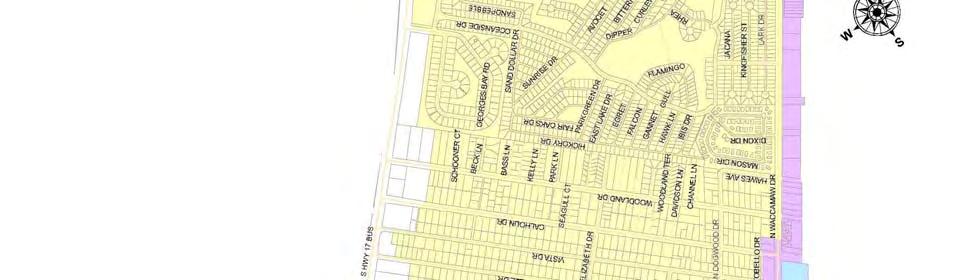
1 723.1 Forestbrook--South Myrtle Beach Area Signage Overlay Zone (A) Purpose: To reduce the visual clutter and aesthetic blight of the Forestbrook--South Myrtle Beach area. (B) Application: The overlay zone shall apply to the area described below and as shown on Attachment 1 following Section Beginning at the intersection of Highway 501 and Forestbrook Road thence heading east to the intersection of Highway 501 and George Bishop Parkway thence south along George Bishop Parkway to a point where George Bishop Parkway and the northern boundary of the Myrtle Beach International Airport (MBIA) property, extended west across Intracoastal Waterway, intersect. From such point, southeast to the intersection of Highway 15 thence northeast to the intersection of Highway 556 (17th Avenue South) thence southeast to the intersection of Ocean Boulevard. Thence south along Ocean Boulevard to 23rd Avenue South thence southeast to the Atlantic Ocean. Thence south along the beach to 17th Avenue North extended. Thence northwest to the intersection of Highway 17 Business thence south to the intersection of Platt Boulevard. Thence northwest to the intersection of Double Eagle Drive thence southwest to Auburn Drive thence west along Bent Grass Drive to the intersection of Highway 17 by-pass. Thence north to a point where the Temperance Drive extended crosses Highway 17 by-pass. Thence northwest to Highway 707. Thence northeast along Highway 707 and Macklen Road to Fairwood Terrace. Thence southwest to Penny Drive. Thence northwest along Ranchette Circle to Hague Drive. Thence north to the Intracoastal Waterway thence west along the Intracoastal Waterway to a point where the southeastern boundary of the Socastee Creek intersects with the Intracoastal Waterway. Thence north along the southeastern boundary of the Socastee Creek to McCormick Road. Thence west to Forestbrook Road thence north to the point of beginning. (C) Applicable supplemental sign regulations: (1) New billboard or off-premise advertising signage shall be limited to those locations where sign permits from both SCDOT and the County are obtained. Locations other than those where both permits are obtained shall not be permitted for billboard or off-premise advertising signage. (2) Existing billboard or off-premise advertising signage may remain and shall comply with the signage standards established in this Ordinance.
2
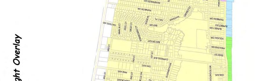
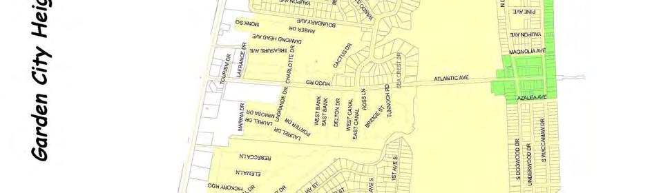
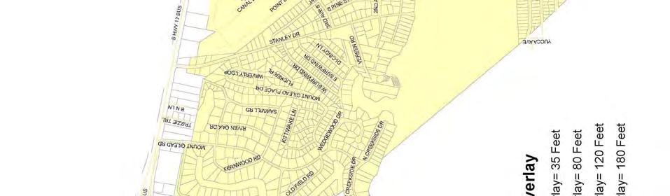
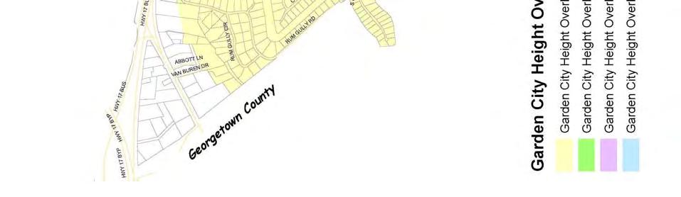
3 723.2 Garden City Height Overlay Zone (A) Purpose The Garden City Height Overlay is established to impose a height restriction on all new construction in the area to prevent over development and development that is incompatible with the character of the area. (B) Application The Garden City Height Overlay shall begin at the southeastern city limit line of Surfside Beach and shall terminate at the Horry County/Georgetown County Line. The exact boundaries of the overlay are shown in Map#2 titled Garden City Height Overlay. (C) Applicable Height Restrictions The height of all new construction within the Garden City Height Overlay shall not exceed thirty-five (35 ) feet, except those areas designated on the attached map, or unless rezoned as a Planned Development District (PDD). A height of up to one hundred eighty (180 ) feet may be approved in a PDD.
4
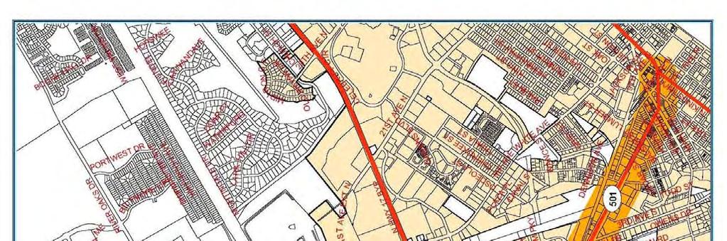
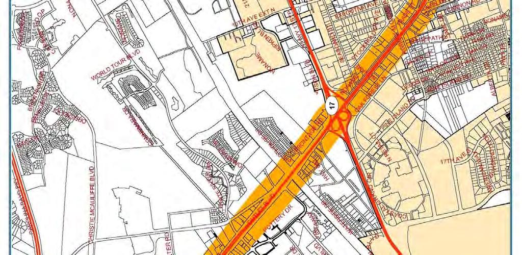
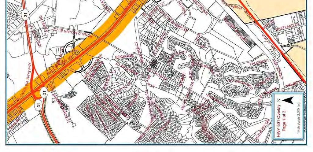
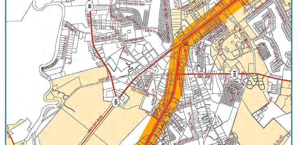
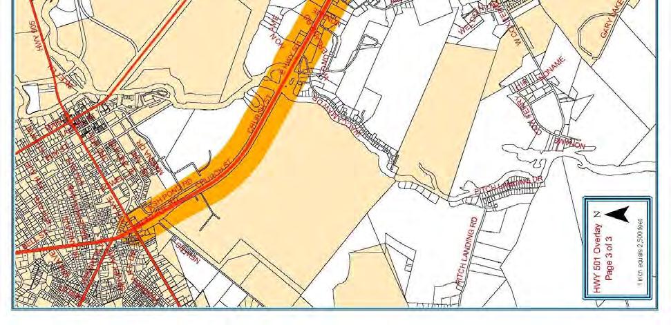
5 723.3 HIGHWAY 501 OVERLAY ZONE (A) Purpose. The Highway 501 Overlay Zone is established to provide standards relative to accessibility, appearance, and safety in the development of commercial, industrial, multi-family residential and office projects that utilize Highway 501 as their primary means of access. The overlay is established to provide unified development that promotes a sense of place and provides opportunities to develop projects engineered to be compatible with the carrying capacity of Highway 501. The following standards provide the minimum requirements that must be met in order to receive Planning Department/Commission authorization to develop or redevelop property with the Highway 501 Overlay Zone as established by Section of the zoning ordinance. (B) Applicability. The Highway 501 Overlay Zone shall begin at the eastern base of the Highway 501 bypass bridge at the Grainger Steam Plant and terminate at the intersection of Canal Street and Highway 501 in the City of Myrtle Beach. The overlay shall extend 500 feet to the north and south of the right-ofway line of Highway 501 as shown in Attachment 1,2 and 3 Highway 501 Overlay. Corridor and overlay are used interchangeably throughout these regulations. Developments partially located within this area, when visible, shall comply with the regulations. Renovated or newly constructed commercial, industrial, multi-family residential, or office developments that are located partially or completely within the boundaries indicated above shall comply with the regulations established below. Construction or renovation not visible from the corridor and singlefamily development are exempt from these regulations. Renovation, for the purpose of the Highway 501 Overlay Zone, is defined as work that modifies or expands a structure or business where the improvements are greater than or equal to 40 percent of the assessed value of the property or the value of the property as determined by an independent appraisal. Water, sewer, or electrical expenditures shall be included in the costs of improvements for any expansion or new construction. General maintenance and repair of any water, sewer, or electrical expenditures incurred in updating an existing structure where no new expansion will occur are exempt from the standards established below. If an existing business is damaged/destroyed due to an act of nature (flood, hurricane, tornado, etc.), or catastrophic event and is reconstructed within 12 months of such damage or destruction, the standards contained herein shall not apply. This exemption shall not relieve the property owner of having to meet applicable building or zoning regulations that may be in place at the time of reconstruction.
6
7
8
9 (C) (D) (E) Required Reviews. Proposed developments or renovations, meeting the above definition shall be reviewed by the Code Enforcement and the Planning and Zoning Departments before issuance of building permits. Development plans shall provide information relative to the site layout including building elevations, landscaping, signage, and utility location. Submitted plans shall comply with the Horry County Plan submittal requirements and contain enough detail to illustrate that the requirements of this ordinance have been meet. Modification of design standards. The Board of Zoning Appeals may approve modification of the design requirements of the overlay zone. Requests for modification of the design standards shall be considered at the time development plans are submitted for review and shall comply with all submittal requirements established in the zoning ordinance. Development & Design Requirements Development of specific uses within the Highway 501 corridor shall be consistent with the underlying zoning district. In addition to the requirements of the applicable underlying zoning district, the following supplemental development regulations shall apply: (1) Buildings: a. Roof mounted mechanical equipment visible from the corridor shall be enclosed or screened to ensure that such features are not visible. Enclosures and screens shall be compatible to the architectural style of the proposed building; b. No portion of a building visible from the traffic lanes of the corridor shall be treated with unadorned concrete masonry units or corrugated and/or sheet metal. Materials suitable for treating visible facades may include, but are not limited to, brick, glass, siding (vinyl or wood), split block, stone, or stucco; c. Shingles, metal standing seam, tile or other roofing materials with similar appropriate texture and appearance shall be utilized on roofs visible from the corridor. Flat roofs are not discouraged where they are appropriate to the design theme of the structure; d. Blank or uninterrupted building facades visible from the corridor shall be designed in a manner that reduces the building mass by breaking the façade into smaller segments. Design techniques that include repetitive features or similar architectural elements may be utilized to accomplish this. (2) Structure Heights: a. Structure heights shall not exceed the underlying zoning districts permitted height, except copulas, spires or other ornamental features may be permitted to
10 increase such height by no more than thirty (30) feet above the allowed roof height as defined in the zoning ordinance. Such increase may be permitted provided there is not conflict with other applicable ordinances (i.e. Airport Height Restrictions). (3) Landscaping and Buffer Requirements To promote a continuous and unified theme, improve the appearance of structures, and provide protection to adjacent properties from the negative impacts of more intense development the following standards shall apply. Acceptable plant species, maintenance standards, and sizes to meet the above requirements are listed in Section 527. a. Foundation Landscaping. Landscaping shall be provided around the foundation of structures visible from any public right-of-way, according to the formula and standards below: 1. Calculation of required landscaping: PR = L or W/ 3.0 Where: PR = number of plants required L or W = building length or width, in feet, visible from any public right-of-way 2. Required plant materials shall be located in a planting area adjacent to the building foundation. If the proposed building is to be accessed by vehicles through service doors and such doors are visible from a public right-of-way, the plant materials required for that length or width shall be exempted from these provisions. 3. For each canopy or understory tree that is provided to meet the foundation landscaping requirements the total number of required plants may be reduced by two (2). b. Perimeter landscaping. A landscape buffer of no less than 25 feet along the corridor and equal to the side and rear setbacks of the underlying zoning district shall be provided around the perimeter of any parcel that directly abuts the corridor. Such buffer shall be improved in accordance with the standards below. When required on-site parking has been located within the buffer, as permitted by these regulations, the remaining buffer area shall be improved with the following standards provided the optional (two) 2foot high berm has not been installed. When non-similarly zoned properties abut, a two (2) foot high berm shall be installed along the sides or rear property lines within the perimeter buffer. Such berm shall be improved in accordance with the standards indicated in Paragraph 3, below. If required on-site parking has been located within the buffer, then the required berm shall be located within the remaining 10 feet of the buffer area.
11 1. The perimeter buffer shall be improved in the following manner: (a) Planted with materials capable of survival in the environment in which they are installed with minimal maintenance; (b) Complement the structure, through color and foliage cover, for which they are planted around; (c) Include the following mixture of plant materials per 100 feet of corridor frontage: 1. Three (3) canopy trees, equally spaced; 2. Three (3) understory trees that flower or have foliage that changes color seasonally equally spaced; shrubs; and 4. Eight (8) evergreens (may be tree or shrub variety) 2. Provide visual direction, through plant heights, to entrances or other access features on the site; 3. Planted in a manner that will not impede traffic safety by blocking or otherwise obscuring traffic signals, signs, or other devices. 4. When a natural, undisturbed buffer is retained along the corridor, sides and rear of a renovated or newly developed property, a waiver of the required perimeter landscaping may be granted. Granting such waiver shall be determined by the Zoning Administrator or designee upon review of a site plan identifying the vegetation retained in the buffers. In no instance shall a waiver be granted if the plants retained in the buffers are not equal, in number not plant type, to those required above. When plants retained do not meet the required numbers of Paragraph (c) above, the Zoning Administrator or designee may give credit for what is retained and require that the buffer along the corridor, sides and rear of the property be supplemented by additional plant materials. Natural, undisturbed buffers meeting the following standards may qualify for the perimeter-landscaping waiver: A 25-foot buffer is retained along the corridor; and Buffers equal to side and rear setbacks are retained; and The plant materials retained shall, at a minimum, consist of trees three (3) inches dbh (diameter at breast height) or greater along the corridor and other vegetation not less than three (3) feet in height or with caliper greater than two (2) inches dbh along the sides and rear of the property. 5. Berm construction requirements When a berm is utilized to provide separation between non-similarly zoned properties or for the purpose of modifying other standards elsewhere required by these regulations it shall adhere to the following:
12 (a) Have side slopes no greater than 2:1; and (b) Be vegetated with the plant materials indicated above, (applies when berm is used between non-similarly zoned properties); and (c) Non-vegetated areas on the berm shall be covered with a groundcover, mulch, or grass suitable to stabilize the side slopes of the berm (used when modifying parking lot location) that will result in the berm obtaining a finished height of no less than three (3) feet. 6. Drainage and utility encroachment into the perimeter buffer Ditches, swales, stormwater conveyance facilities, stormwater retention ponds, sanitary sewer conveyance facilities, and associated easements may encroach up to 50% into the buffer area or a required screening berm. When a drainage or utility encroachment requires more than a 50% reduction, a request for increased encroachment may be submitted to the Board of Zoning Appeals for consideration. Such request shall be submitted when the development site plan is submitted for review. (6) Access management. To ensure that development of the within the corridor does not impact the carrying capacity or future improvement of Highway 501 the following access management strategies shall be employed.
13 a. Parcel Access 1. Parcels having 200 or more feet of corridor frontage shall be permitted one access point to the corridor. Additional access points may be permitted provided their location is no closer than 300 feet to any other access point and their design adheres to the SCDOT Access and Roadside Management Standards. 2. Points of access to parcels with less than 200 feet of corridor frontage shall be subject to SCDOT approval. A copy of the encroachment permit shall be provided at the time plans are submitted for review. 3. Parcels located at an intersection of Highway 501 and another improved public roadway shall obtain access from the adjacent public roadway. Direct access to the corridor may be permitted when the parcel has 300 or more feet of corridor frontage, the access is no closer than 300 feet to another access, and the access is approved by SCDOT. 4. When applicable, access to a parcel shall be aligned directly with existing median crossovers. Accesses that do not align directly shall be located a minimum of 100 feet (edge to edge) from the nearest crossover. 5. Parcels accessing frontage roads, currently or in the future, shall be permitted one access point per 200 feet of frontage. Additional access points may be permitted if justified by a traffic study. b. Consolidation of access points. Reductions of access points to the corridor are encouraged due to the increases in operational efficiency that result. When any of the following strategies are used, participating businesses shall be entitled to the variations listed below. 1. Shared or joint access. Use of shared or joint access between two or more properties shall allow required parking for the adjacent uses to be reduced up to 25%. 2. Cross-access easements. Use of cross-access easements between properties resulting in access to parcels being restricted to existing median crossovers shall be entitled the following: (a) Required parking for adjacent uses shall be reduced up to 25%; and (b) Frontage landscaping and buffer requirements shall be reduced up to 30%. 3. Extension of frontage roads (applies to properties west of Forestbrook Road only). When the construction of or transfer of property for the construction of frontage roads, consistent with the SCDOT and GSATS frontage road plan, occurs the following shall apply: (a) Required parking for adjacent uses shall be reduced up to 25%; (b) Frontage landscaping and buffer requirements shall be reduced up to 30%; and
14 (c) Individual parcels accessing the frontage road shall be allowed one access point for each 200 feet of frontage. Additional accesses may be permitted if justified by a traffic study. c. Parking lot access. Parking lots that directly access the corridor or a frontage roadway shall: 1. Be designed to ensure that entering vehicles maintain a travel speed of 15 mph to assist in reducing interference with through street traffic movements. 2. Provide an entrance drive throat length of no less than 100 feet to reduce conflicts between entering and exiting vehicles. Developments that generate less than 500 ADTs shall be exempt from this standard. 3. Set back required landscaping or optional berming to ensure that a site triangle, conforming to SCDOT standards, exists. (7) Parking. To reduce the visual mass and enhance the appearance of parking areas from the corridor, the following standards shall be met. Display lots used in connection with businesses engaged in the sale, lease or rental of merchandise are exempt from the standards provided; however; that the landscaping and buffer requirements of are met. Parking lots for proposed structures shall be distributed around the front or sides of the structure and outside the perimeter buffer as required in subsection 3.b of these regulations. Parking may be located behind the proposed structure if desired. Parking may be located within the perimeter buffer when the standards below, are met. a. Parking areas shall be screened from the corridor. Screening may be accomplished in any of the following ways: 1. Retention of the natural vegetation within the perimeter buffer provided such vegetation is consistent with the requirements of Article 527 or 2. Placement of landscaping in the perimeter buffer that is consistent with the material requirements of (3).b.1 above; or 3. Placement of a berm no less than two (2) feet in height and planted with a stabilizing ground cover resulting in a total height of three (3) feet. 4. Parking spaces may encroach into the buffer area provided: (a) Parking is no closer than ten (10) feet from the property line; and (b) Required landscaping displaced by the parking area is redistributed throughout the site; and (c) Remaining buffer area between the parking spaces and the property line must be improved with landscaping consistent with the requirements of (3).b.1 above or a two-foot high berm improved as required in (3).b.5 above. 5. Parking areas shall be designed so that no one parking module contains more than 150 spaces. Parking within modules shall be grouped so that 9 x 15 parking
15 islands are provided for every 20 parking spaces in a continuous row or for a maximum of 40 spaces per bay between parking islands. Parking islands shall be surrounded by curbing to prevent vehicular intrusion and improved with at least one (1) 2-½ inch caliper canopy tree to reduce parking lot heat and glare. The remaining area of the parking island shall be planted with vegetation that complements the structure or a suitable groundcover. ( (a) Acceptable plant species, maintenance standards, and sizes to meet the above requirements are listed in Table 1 (located at the end of this Article). (b) Parking areas containing more than 150 spaces, in addition to the meeting the requirements of Subsection 4 above shall also provide a 10-foot landscaped island between each parking module. Landscaping placed within such islands shall be sufficient to provide visual relief from the mass of the parking area. (See Figure 4 located at the end of this Article) (c) Parking areas shall be lit to provide safety for the patrons utilizing the lot. Lighting shall be no greater than 35 feet in height and shall be directed to ensure no spillover lighting occurs on adjacent properties or public rights-ofway. 5. Parking space reductions. The number of required parking spaces, may be reduced under the following conditions: (a) The reduction is no greater than 15 percent of the total parking required for the proposed use; and (b) The perimeter buffer is increased to 35feet and the required landscaping is increased at a rate of 25 percent of that required in (3).b.1 above; or (c) Parking islands are provided for every 15 parking spaces in a continuous row or for a maximum of 30 spaces per bay between parking islands. Such islands shall be improved as specified in Subsection 4, above.
16
17 (8) Signage a. On-site signage requirements. To reduce sign clutter in the corridor, the following standards shall apply to onsite signage: 1. Signage Allowed by Property Type and Corridor Frontage Type of Property (1) Freestanding single parcel Freestanding single parcel Freestanding Single parcel Commercial Center (6) Out-parcel that is part of a commercial center (5) Length of Corridor Frontage Number of Signs (2) Type of Sign Height (3) Sign Area Computation (4) Less than 200 feet 1 Monument 8 feet 1 sq. ft. for each linear ft. of frontage feet 1 Freestanding 35 feet More than 400 feet Freestanding 50 feet 2 sq. ft. for each or portion thereof up to 799 feet "primary" 1 - Freestanding "secondary" 25 feet linear ft. of frontage Over 800 feet 1 additional Freestanding 25 feet "secondary" More than 400 feet Freestanding 50 feet 2 sq. ft. for each or portion thereof "primary" linear ft. of frontage up to 799 feet 1 - Freestanding 25 feet "secondary" Over 800 feet 1 additional Freestanding 25 feet "secondary" Less than 400 feet 1 Monument 8 feet 1 sq. ft. for each linear ft. of frontage Notes: 1. When a site's primary or secondary access is from a roadway other than the corridor, one (1) identification sign, 25 feet in height, for every 400 feet of roadway frontage shall be permitted. 2. In no instance shall a site have more than three (3) freestanding signs. 3. Sign height shall be measured from finished grade. 4. Maximum sign area per site shall be no greater than 750 sq.ft. Out-parcels of a commercial center, as defined below, shall not be counted as part of the commercial center maximum sign area. 5. Out-parcels located on the corner of property within a commercial center shall be permitted two 8-foot high monument-style signs, one on each roadway frontage. 6. Signage on parcels improved with commercial centers, as defined below, shall be calculated based on the total roadway frontage that such parcel has inclusive of any out-parcels that may be part of the commercial center. Signage for out-parcels that are part of a commercial center shall be calculated as shown in the above table. A Commercial Center is defined as a development where more than two (2) businesses are located in a single structure and where there may be additional detached structures on the property that are on out-parcels, leased or owned fee-simple. 2. On-site signage design requirements. To enhance the appearance of on-site signage in the corridor the following standards shall apply to on-site signage. (a) Freestanding and monument-style signage shall be architecturally designed to reflect the character of the structure for which they are advertising.
18 (b) Animated signs or signs with flashing lights are prohibited in the corridor, except that time and temperature boards, electronic message centers, tri-vision boards, and light emitting diode (LED) displays may be allowed. (c) Internal illumination of freestanding signs shall be required. Monument-style signage may be externally lit provided the illumination source is shielded from the corridor. When internal illumination of freestanding signage is not possible, the Zoning Administrator may permit external illumination. b. Off-premise advertising signage. The following requirements shall pertain to the placement of off-premise advertising signage in the corridor. RESERVED
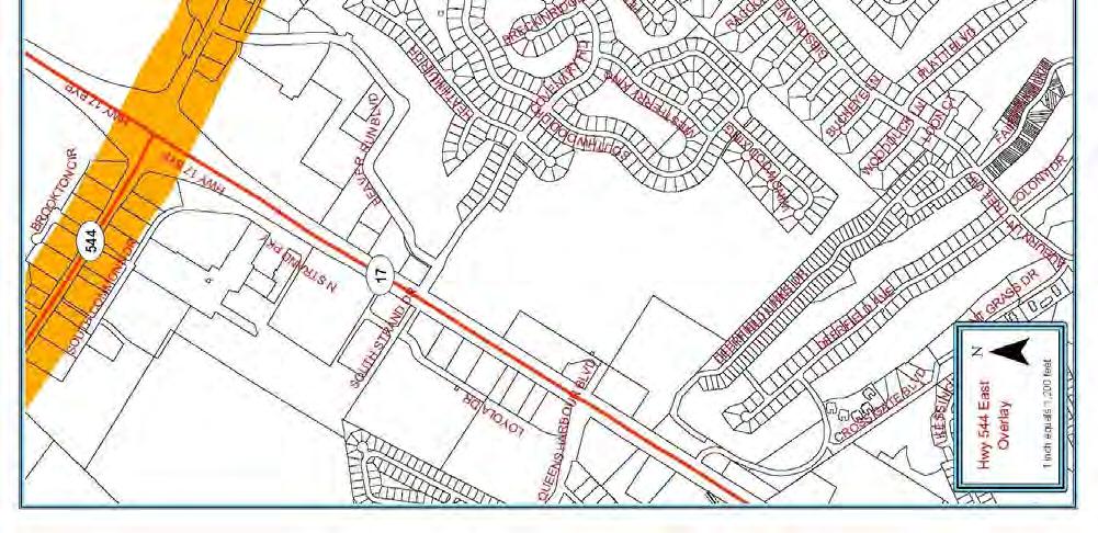
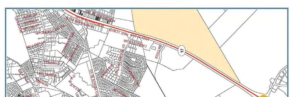
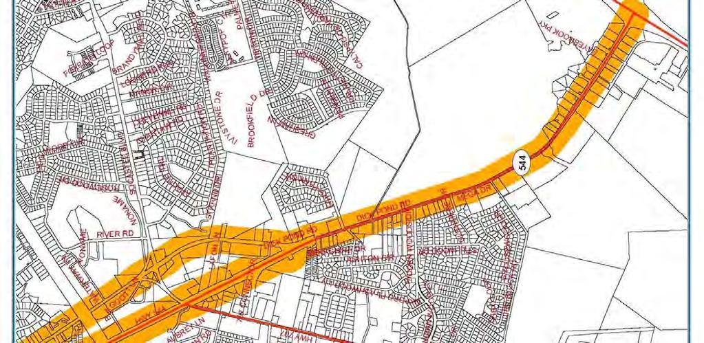
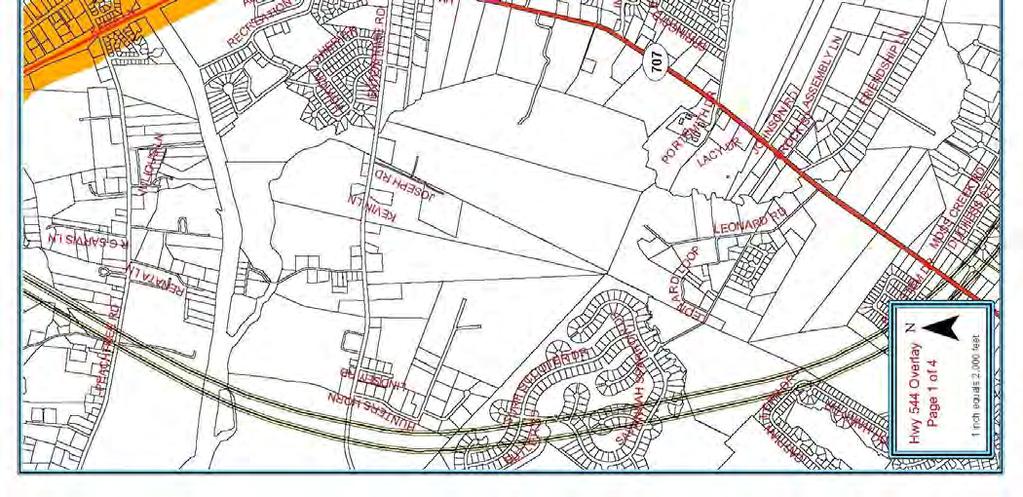
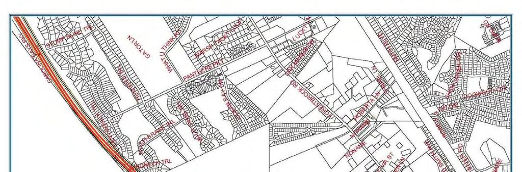
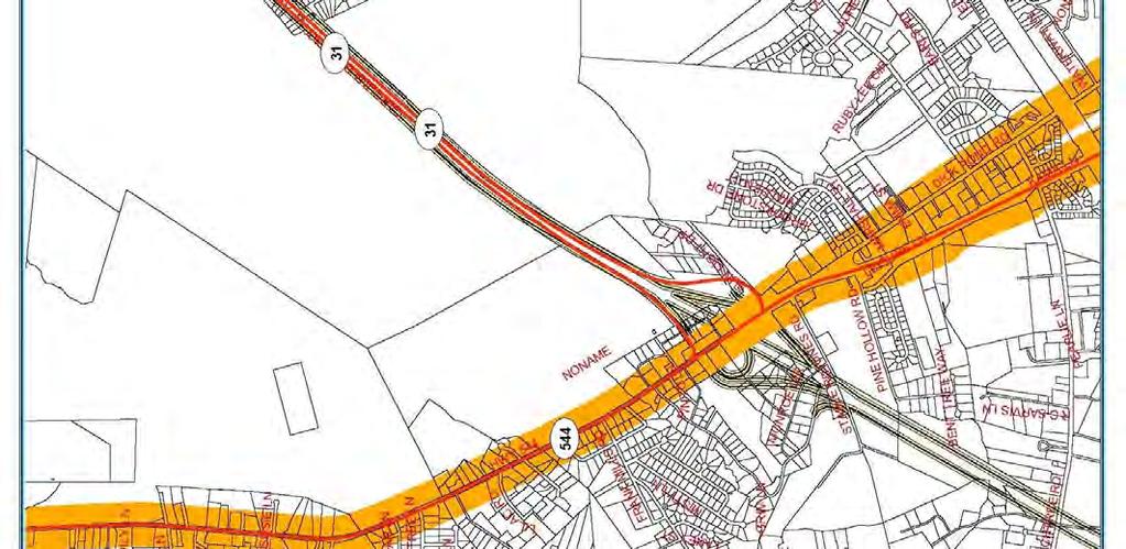
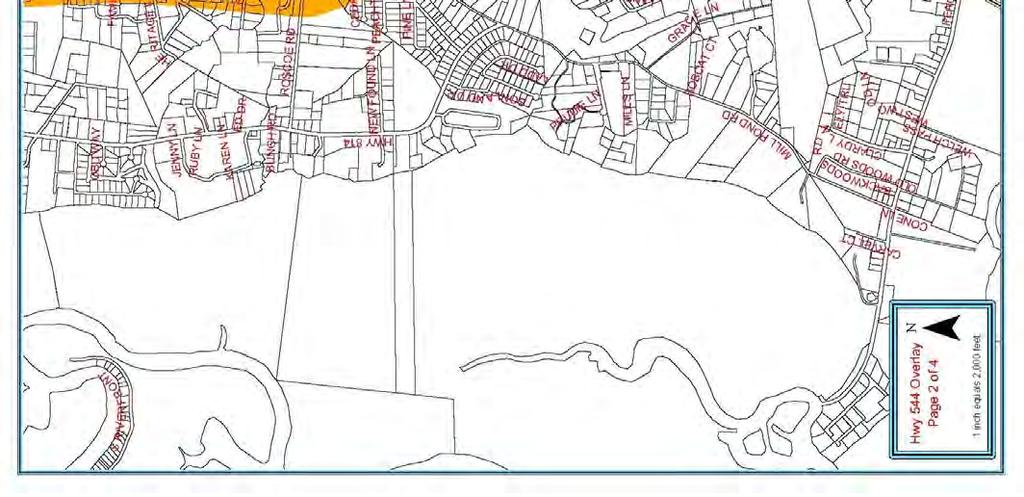
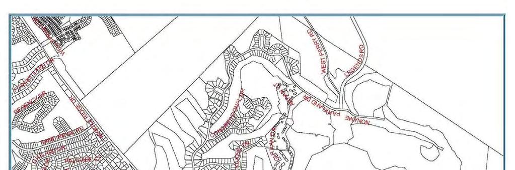
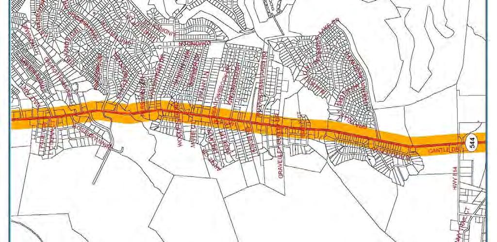
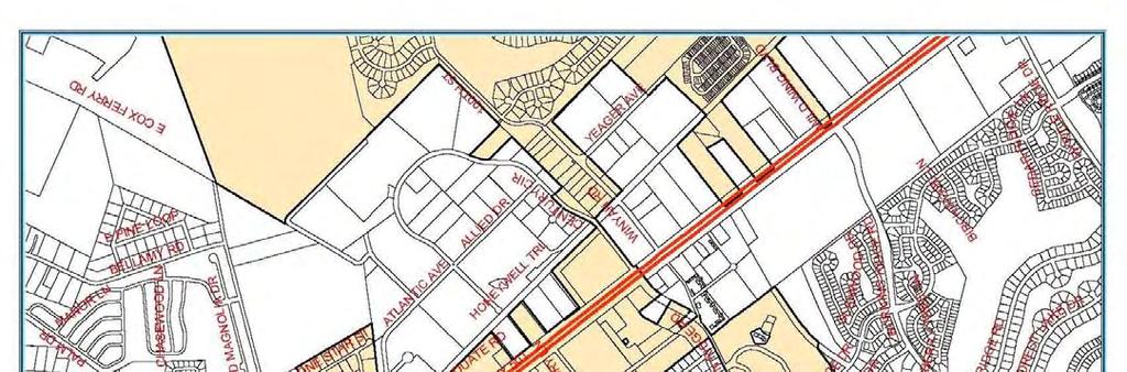
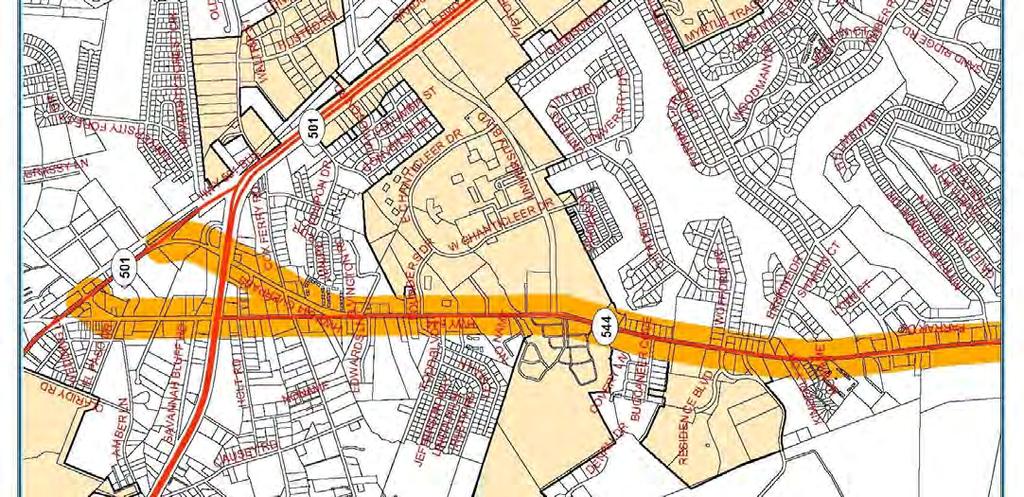
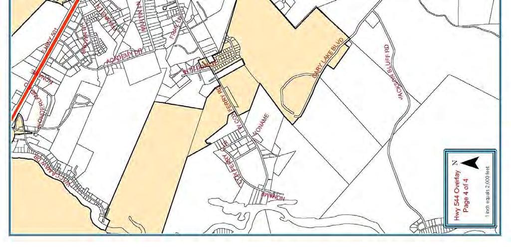
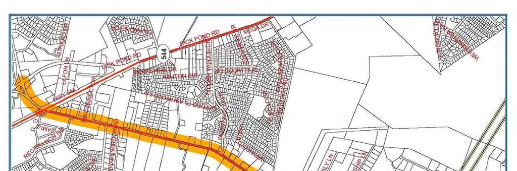
19 723.4 Highway 544 Overlay Zone (A) (B) Purpose. The Highway 544 Overlay Zone is established to provide standards relative to accessibility, appearance, and safety in the development of commercial, industrial, multi-family residential, and office projects that utilize Highway 544 as their primary means of access. Furthermore, the overlay is established to provide unified development that promotes a sense of place and provides opportunities to develop projects engineered to be compatible with the carrying capacity of Highway 544 as a major transportation corridor. When any existing county ordinance is amended, the more restrictive provisions of such revised ordinance shall apply even if these overlay zone standards are more relaxed. Applicability. The Highway 544 Overlay Zone shall be divided into two segments. The first section shall be called the East Highway 544 Overlay and shall begin at the intersection of Highway 17 Bypass and Highway 544 and terminate at the intersection of Highway 17 Business and Highway 544 near Surfside Beach, SC. The second section will be called the West Highway 544 Overlay and shall begin at the intersection of Highway 17 Bypass and Highway 544 and will run north to the intersection of old Highway 544 and Highway 501 Bypass and end at the stoplight as well as run north and terminate at the beginning of the Highway 544 bridge over Highway 501 Bypass near Conway, SC. The Overlay segments shall generally extend 300 feet to either side of the right-of-way lines of Highway 544 except where Highway 544 has been relocated from its former alignment that followed Dick Pond Road. In such instance, the boundaries of the Overlay shall include the properties that are located between these roadways and shall extend 300 feet to the east and west of the right-of-way lines of those roadways. Furthermore, at the northern terminus of the Overlay, the boundaries shall include the rightsof-way of the old Highway 544 which splits to the left from Highway 544 Bypass just south of Highway 501 Bypass and which runs north and ends at the intersection of old Highway 544 and Highway 501 Bypass at the stoplight. The northern terminus also includes the section of Highway 544 Bypass which splits to the right from the old Highway 544 intersection just south of Highway 501 Bypass and thus runs north over the bridge over Highway 501 Bypass and ends at the intersection of Highway 501 Business which is north of Highway 501 Bypass. See map in attached maps for Hwy 544 East and West Pages 1 thru 4. Renovated or newly constructed commercial, industrial, multi-family residential, or office developments that are located partially or completely within the boundaries indicated above shall comply with the regulations established below. Construction or renovation not visible from the corridor and singlefamily development are exempt from these regulations.
20 Renovation is defined as: Work that modifies or expands a structure or business where the improvements are equal to or greater than 40% of the properties assessed value or the value of the property as determined by an independent appraisal. Water, sewer, or electrical expenditures shall be included in the costs of improvements for any expansion or new construction. General maintenance and repair of any water, sewer, or electrical expenditures incurred in updating an existing structure where no new expansion will occur are exempt from the standards established below. If an existing business is damaged or destroyed due to an act of nature (flood, hurricane, tornado, etc.), or catastrophic event and is reconstructed within 12 months of such damage or destruction, the standards contained herein shall not apply. This exemption, however, shall not relieve the property owner of having to meet applicable building or zoning regulations that may be in place at the time of reconstruction. Corridor and overlay are used interchangeably throughout these regulations. When referenced, it shall mean the area generally 300 feet to the east and west of the Highway 544 right-of-way lines between the established beginning and ending points indicated above. Developments partially located within this area, when visible, shall comply with the regulations. Where appropriate, specific standards applicable to either the East or West segments of the Overlay will be duly noted. When no specific segment has been identified within the standards, such standard shall apply to the entire Overlay. (C) (D) Required Reviews. Proposed developments or renovations, meeting the above definition shall be reviewed by the Code Enforcement and the Planning and Zoning Departments before issuance of building permits. Development plans shall provide information relative to the site layout including building elevations, landscaping, signage, and utility location. Submitted plans shall comply with the Horry County Commercial Plan submittal requirements and contain enough detail to illustrate that the requirements of this ordinance have been meet. Modification of design standards. The Board of Zoning Appeals may approve modification of the design requirements of the overlay zone. Requests for modification of the design standards shall be considered at the time development plans are submitted for review and shall comply with all submittal requirements established in the zoning ordinance.
21
22
23
24
25
26 (E) Development and design requirements. Development of specific uses in the Highway 544 Overlay Zone shall be consistent with the underlying zoning district. In addition to the requirements of the applicable underlying zoning district the following supplemental development regulations shall apply. (1) Buildings a. Roof mounted mechanical equipment visible from the corridor shall be enclosed or screened to ensure that such features are not visible. Enclosures and screens shall be compatible to the architectural style of the proposed building; b. No portion of a building visible from the traffic lanes of the corridor shall be treated with unadorned concrete masonry units or corrugated and/or sheet metal. Materials suitable for treating visible facades may include, but are not limited to, brick, glass, siding (vinyl or wood), split block, stone, or stucco; c. Shingles, metal standing seam, tile or other roofing materials with similar appropriate texture and appearance shall be utilized on roofs visible from the corridor. Flat roofs are not discouraged where they are appropriate to the design theme of the structure; d. Blank or uninterrupted building facades visible from the corridor shall be designed in a manner that reduces the building mass by breaking the façade into smaller segments. Design techniques that include repetitive features or similar architectural elements may be utilized to accomplish this. (See Figure 1 located at the end of Article 11) (2) Structure Heights a. Structures within the East Highway 544 section located to the south of the Highway 544 right-of-way shall not exceed 35 feet in height as defined in Article 17 (Definitions) of the zoning ordinance. The structures east of Southwood Drive and going all the way to Highway 17 Business shall maintain the general appearance of a typical two story residential type construction with a pitched roof, or have alternate designs approved by the Board of Zoning Appeals; and b. Structures within the East Highway 544 section located to the north of the Highway 544 right-of-way as well as the entire West Highway 544 section shall not exceed 50 feet, except that copulas, spires, or other ornamental features are permitted to increase such building heights to 75 feet as defined in Article 17 (Definitions) of the zoning ordinance. However, new proposed structure located within 100 feet of an existing residential structure for which a certificate of occupancy has been issued, shall have a maximum height of 35 feet of living space. The roof, copulas, spires, or other ornamental features are permitted to increase building height to 50 feet, but the height of the living space can be no higher that 35 feet. (3) Landscaping and buffer requirements
27 To promote a continuous and unified theme, improve the appearance of structures and provide protection to adjacent properties from the negative impacts of more intense development, the following standards shall apply. Acceptable plant species, maintenance standards, and sizes to meet the above requirements are listed in Section 527. a. Foundation Landscaping. Landscaping shall be provided around the foundation of structures visible from any public right-of-way, according to the formula and standards below: 1. Calculation of required landscaping: PR = L or W/ 3.0 Where: PR = number of plants required L or W = building length or width, in feet, visible from any public right-of-way 2. Required plant materials shall be located in a planting area adjacent to the building foundation. If the proposed building is to be accessed by vehicles through service doors and such doors are visible from a public right-of-way, the plant materials required for that length or width shall be exempted from these provisions. 3. For each canopy or understory tree that is provided to meet the foundation landscaping requirements the total number of required plants may be reduced by two. b. Perimeter landscaping. A landscape buffer shall be provided around the perimeter of any parcel that directly abuts the corridor. The buffer shall be equal to the width of the setback required for the underlying zoning district except that the front buffer may be reduced to 25 feet or 10% of a parcel s depth, whichever is less. No landscape buffer will be required on any part of a parcel that abuts wetlands. Additional landscaping requirements will not be required between parcels with the same zoning designation. Such buffer shall be improved in accordance with the standards below. 1. When any non-residential zoned properties being developed abut a residential zoned property, one of the following four options shall be installed along the sides or rear property lines which abuts that residential property within the perimeter buffer of the newly developed site: A 4-foot high berm can be installed; or A 2-foot high berm can be installed along with 3 feet of plantings; or Plant landscape material in a staggered planting scheme at a 5 foot height at the time of planting with no berm included; or A 6-foot wood fence.
28 2. No fence, berm, or landscape material shall be designed or located in a manner that obstructs the vision of vehicular traffic at street and/or driveway intersections. Any plantings installed above are required within five years to achieve summer season opacity factor of at least 80%. Opacity is hereby defined as: The state of being impervious or impenetrable to the passage of light or allowing visual access to objects located behind natural or man-made features. The Zoning Administrator or designee shall inspect any suspected violations of the opacity standards specified herein at least three areas within required buffer area. Each area to be inspected will be an 8-foot length of the required vegetation screening from the ground to the average top height of the vegetation. An inspection estimate indicating 20% or less of light penetration or complete visual penetration will satisfy the 80% opacity factor. Any inspection estimate higher than 20% of light penetration or complete visual penetration will be considered to fail the 80% opacity factor. Any inspections that result in a failure will be reported to the property owner. Failure of that property owner to correct the situation within 45 days will constitute a violation of the zoning ordinance and be subject to the fines and penalties specified therein. 3. When a new residential development is created adjacent to or abutting to an existing non-residential zoned property within the 300-foot corridor, it is the responsibility of that new residential development to create one of the four options of berms and/or vegetation planting listed above. 4. The perimeter buffer shall be improved in the following manner: (a) Be planted with materials capable of survival in the environment in which they are installed with minimal maintenance; and (b) Complement the structure, through color and foliage cover, for which they are planted around; and (c) Include the following mixture of plant materials per 100 feet of buffer length: 3 canopy trees or palmetto trees, equally spaced; 3 understory trees that flower or have foliage that changes color seasonally, equally spaced 20 shrubs; and 8 evergreens (may be tree or shrub variety) 5. Provide visual direction, through plant heights, to entrances or other features to the site; and 6. Be planted in a manner that will not impede traffic safety by blocking or otherwise obstructing traffic signals, signs, or other devices.
29 7. When a natural, undisturbed buffer is retained along the corridor, sides and rear of a renovated or newly developed property a waiver of the required perimeter landscaping may be granted. Granting such waiver shall be determined by the Zoning Administrator or designee upon review of a site plan identifying the vegetation retained in the buffers. In no instance, shall a waiver be granted if the plants retained in the buffers are not equal, in number not plant type, to those required above. When plants retained do not meet the required numbers above, the Zoning Administrator or designee may give credit for what is retained and require that the buffer along the corridor, sides and rear of the property be supplemented by additional plant materials. Natural, undisturbed buffers meeting the following standards may qualify for the perimeter-landscaping waiver: A 25-foot buffer is retained along the corridor; and A 20-foot buffer is retained along the sides and rear of the parcel; and The plant materials retained shall, at a minimum, consist of trees 3 inches dbh (diameter at breast height) or greater along the corridor and other vegetation not less than 3 feet in height or with caliper greater than 2 inches dbh along the sides and rear of the property. 8. Berm construction requirements. When a berm is utilized to provide separation between non-similarly zoned properties or to modify standards required elsewhere by these regulations, it shall adhere to the following: (a) Have side slopes no greater than 2:1; Any alternative designs shall be noted on all plans; and (b) Be vegetated with the plant materials indicated above. (c) Non-vegetated areas on the berm shall be covered with a groundcover, mulch, or grass suitable to stabilize the side slopes of the berm (used when modifying parking lot location) 9. Drainage and utility encroachment into the perimeter buffer. Ditches, swales, stormwater conveyance facilities, stormwater retention ponds, sanitary sewer conveyance facilities, and associated easements may encroach up to 10% into the buffer area or a required screening berm. When a drainage or utility encroachment requires more than the 10% reduction allotted, a request for increased encroachment may be submitted to the Planning Commission for consideration. Such request shall be submitted when the development site plan is submitted for review.
30 (4) Leasing, rental, or sale facilities. Businesses engaged in the leasing, rental, or sale of merchandise that have frontage along the corridor shall adhere to the landscaping and buffer requirements indicated in subsection E, above, and item 1, below. Display lots associated with such businesses are exempt from the parking area requirement. Each business shall be permitted one display pad, no larger then 200 square feet, for merchandise sold at such establishment. An additional display pad shall be permitted for each 200 feet of corridor frontage. The display pad shall be located behind the required perimeter buffer and may be elevated a maximum of 18 inches above finished grade. (5) Shipping/receiving areas and utility location a. Proposed structures, visible from the corridor, requiring shipping docks for the receipt or shipping of merchandise shall locate such docks in the rear of the structure or within a service courtyard shared by different businesses. Shared courtyards may be accessed from the front of the structure provided the entrance to such area is designed to blend into the architectural style of the structure and no docks are visible from the corridor or adjacent parking areas. b. Utility services shall be located underground when possible. If underground utility location is not possible, above grade utilities shall be located behind structures in a utility "alley" easement approved by the applicable utility authority. (6) Salvage yards, automobile repair facilities and mini-warehouses. Businesses engaged in salvage operations, repair of automobiles or storage of possessions in individually enclosed units/garages that have frontage along the corridor shall adhere to the standards provided in subsection (3).b.4, above, and the following: a. Storage areas for salvaged materials or vehicles waiting for repair shall be screened from the corridor by a six foot high opaque enclosure or equal to the height of the stored material not to be higher than 20 feet which shall be located to the rear or side of the primary structure on the site; and b. A 10-foot wide landscaped buffer shall be provided around the base of the enclosure to soften its appearance. Landscaping utilized shall be consistent with that required in subsection (3)b.4, above. (7) Access management To ensure that development within the corridor does not impact the carrying capacity or future improvement of Highway 544, the following access management strategies shall be employed.
31 a. Parcel Access 1. Every property owner will be allowed access to Highway 544 from their property. Shared driveways are encouraged. Additional access points may be permitted provided their location and design adheres to the SCDOT Access and Roadside Management Standards. A copy of the encroachment permit shall be provided at the time plans are submitted for review. 2. Parcels located at an intersection of Highway 544 and another improved public roadway shall obtain access from the adjacent public roadway. Direct access to the corridor may be permitted when the parcel has 200 or more feet of corridor frontage, the access is no closer than 200 feet to another access, and the access is approved by SCDOT. 3. When applicable, access to a parcel shall be aligned directly with existing median crossovers. Accesses that do not align directly shall be located a minimum of 100 feet (edge to edge) from the nearest crossover. b. Consolidation of access points Reduction of access points to the corridor are encouraged due to the increases in operational efficiency that result. When any of the following strategies are used, participating businesses shall be entitled to the variations listed below. 1. Shared or joint access. Use of shared or joint access between two or more properties shall allow required parking for the adjacent uses to be reduced up to 25%. 2. Cross-access easements. Use of cross-access easements between properties resulting in access to parcels being restricted to existing median crossovers shall be entitled to reduce required parking up to 25%. c. Parking lot access Parking lots that directly access the corridor or a frontage roadway shall: 2. Be designed to ensure that entering vehicles maintain a travel speed of 15 mph to assist in reducing interference with through street traffic movements. 3. Provide an entrance drive throat length of no less than 100 feet to reduce conflicts between entering and exiting vehicles. Developments that generate less than 500 ADTs shall be exempt from this standard. 4. Place required landscaping or optional earthen berms outside required site triangles. (8) Parking areas To reduce the visual mass and enhance the appearance of parking areas from the corridor, a front buffer of twenty-five (25) feet or ten percent of a parcel's depth,
32 whichever is less, and side and rear buffers equal to the side and rear setbacks of the underlying zoning district shall be installed and improved with landscape materials specified in (3)b.4, above. Display lots used in connection with businesses engaged in the sale, lease or rental of merchandise are exempt from the following standards; however; shall be required to comply with the landscaping and buffer requirements of (3)b.4, above. a. Parking lots shall be distributed around the front or sides of proposed structures and outside the perimeter buffer. Parking may be located behind the proposed structure if desired. b. Parking areas shall be screened from the corridor. Screening may be accomplished in any of the following ways: 1. Through retention of the natural vegetation within the perimeter buffer provided such vegetation is consistent with the requirements of (3)b-7 above; or 2. Through the placement of landscaping in the perimeter buffer that is consistent with the material requirements of (3).b.4; or 3. Through the placement of a berm no less than two feet in height and planted with a stabilizing ground cover or plant material resulting in a total height of 4-feet. c. Parking areas shall be designed so that no one parking module contains more than 150 spaces. Parking within modules shall be grouped so that 9 x 14 parking islands are provided for every 20 parking spaces in a continuous row or for a maximum of 40 spaces per bay between parking islands. Parking islands shall be surrounded by curbing to prevent vehicular intrusion and improved with at least one 2-½ inch caliper canopy tree to reduce parking lot heat and glare. The remaining area of the parking island shall be planted with vegetation that complements the structure or a suitable groundcover. d. Parking areas containing more than 150 spaces, in addition to the meeting the requirements above, shall also provide a 10-foot landscaped island between each parking module. Landscaping placed within such islands shall be sufficient to provide visual relief from the mass of the parking area. e. Parking areas shall be lit to provide safety for the patrons utilizing the lot and shall have their height restricted as follows: 9. Parking lot lighting in both the East Highway 544 and West Highway 544 sections shall have lighting no greater than 25 feet in height; and 10. New businesses, which can justify to the Zoning Administrator or their designee, their need to install parking lot lighting higher than 25 feet, may be exempt from this restriction; and 11. Lighting required for special events will be exempt from this ordinance; and 12. All lighting shall be directed to ensure no spillover lighting occurs on adjacent properties or public rights-of-way and shall not cause illumination in excess of one (1) foot candle across any residential lot line in any residential district.
33 f. Parking space reductions. The number of required parking spaces, as determined by the zoning ordinance, may be reduced under the following conditions: 1. The reduction is no greater than fifteen (15) percent of the total parking required for the proposed use; and 2. The perimeter buffer is increased to thirty-five (35) feet and the required landscaping is increased at a rate of twenty-five (25) percent of that required in (3).b.4; or 3. Parking islands are provided for every 15 parking spaces in a continuous row or for a maximum of 30 spaces per bay between parking islands. Such islands shall be improved as specified above.
34 (9) Signage a. On-site signage requirements. To reduce "overload" and sign clutter in the corridor, the following standards shall apply to on-site signage. For developments within the East and West Highway 544 sections the following shall apply: 1. Properties with 400 feet of corridor frontage shall be permitted one 35-foot tall freestanding primary identification sign. For each additional 400 feet of corridor frontage, an additional identification sign, 25 feet in height, shall be permitted. In no instance shall a site have more than three on-site freestanding signs. 2. Out-parcels that are a part of a major commercial development which have less than 400 feet of corridor frontage shall be permitted one 8-foot high monumentstyle sign from finished grade. For corner out-parcels, two monument-style signs shall be permitted one per frontage. 3. Individual parcels with between 200 and 400 feet of corridor frontage shall be permitted one freestanding sign, 25 feet in height. Individual parcels with less than 200 feet of corridor frontage shall be limited to one 8-foot high monumentstyle sign from finished grade. 4. When a site s primary or secondary access is from a roadway other than the corridor, one identification sign, 25 feet in height, for every 400 feet of roadway frontage shall be permitted. Notwithstanding item a above, the total number of on-site freestanding signs shall not exceed three. 5. Freestanding and monument-style sign area (advertising area) shall be determined by the amount of frontage the parcel has on the corridor. For parcels with less than 400 feet of frontage, the sign area shall equal ½ a square foot or portions thereof rounded up to the nearest one square foot of sign area for every one-foot of roadway frontage. For parcels with greater than 400 feet of frontage, the sign area may equal to ½ a square foot for the first 400 feet of frontage plus an additional 1 square foot of sign area for each additional 1 foot of frontage beyond the initial 400 feet. In no case shall total sign area on a site, excluding outparcels, exceed 750 sq.ft. For any site, which has more than one sign as addressed in a above, the total combined sign area for all of the signs shall not exceed 750 sq. ft. For small odd shaped parcels or lots with unique situations, a minimum of 50 square feet of sign area will be allowed. The sign area for the East Highway 544 section located to the south of the Highway 544 right-of-way shall have a maximum of 200 square feet. The maximum sign area allowed for any 8-foot sign will be 100 square feet. The sign area or advertising area computation standard is established in the Zoning Ordinance. 6. Freestanding and monument-style signage shall be architecturally designed to reflect the character of the structure for which they are advertising. 7. Animated signs or signs with flashing lights are prohibited in the corridor, except that time temperature boards, and light emitting diode (LED) displays shall be allowed. 8. Internal illumination of freestanding sign shall required. Monument style-signage may be externally lit provided the illumination source is shielded from the
35 corridor. When internal illumination of freestanding signs is not possible, the Zoning Administrator may permit external illumination. Signage Allowed by Property Type and Corridor Frontage Type of Property (1) Length of Corridor Frontage Number of Signs (2) Type of Sign Height (3) Sign Area Computation(4) Freestanding single parcel Less than 200 feet 1 Monument 8 feet Freestanding single parcel feet 1 Freestanding 25 feet 1/2 sq. ft. for each linear ft. of frontage Freestanding Single parcel Commercial Center (6) Out-parcel that is part of a commercial center (5) More than 400 feet or portion thereof up to 799 feet Each additional 400 feet of frontage More than 400 feet or portion thereof up to 799 feet Each additional 400 feet of frontage Freestanding "primary" Freestanding "secondary" Freestanding "primary" Freestanding "secondary" 35 feet 25 feet 35 feet 25 feet 1/2 sq. ft. for each linear ft. of frontage up to 400 feet plus 1 sq. ft. for each linear ft. of frontage over 400 feet. 1/2 sq. ft. for each linear ft. of frontage up to 400 feet plus 1 sq. ft. for each linear ft. of frontage over 400 feet. Less than 400 feet 1 Monument 8 feet 1/2 sq. ft. for each linear ft. of frontage Notes: 1. When a site's primary or secondary access is from a roadway other than the corridor, one identification sign, 25 feet in height, for every 400 feet of roadway frontage shall be permitted. 2. In no instance shall a site have more than three (3) freestanding signs. 3. Sign height shall be measured from finished grade. 4. Maximum sign area per site shall be no greater than 750 sq.ft. Out-parcels of a commercial center, as defined below, shall not be counted as part of the commercial center maximum sign area. 5. Out-parcels located on the corner of property within a commercial center shall be permitted two 8-foot high monument-style signs, one on each roadway frontage. 6. Signage on parcels improved with commercial centers, as defined below, shall be calculated based on the total roadway frontage that such parcel has inclusive of any out-parcels that may be part of the commercial center. Signage for out-parcels that are part of a commercial center shall be calculated as shown in the above table. A Commercial Center is defined as a development where more than two (2) businesses are located in a single structure and where there may be additional detached structures on the property that are on out-parcels, leased or owned fee-simple. b. Off-premise advertising signage. The following requirements shall pertain to the placement of off-premise advertising signage in the corridor. RESERVED
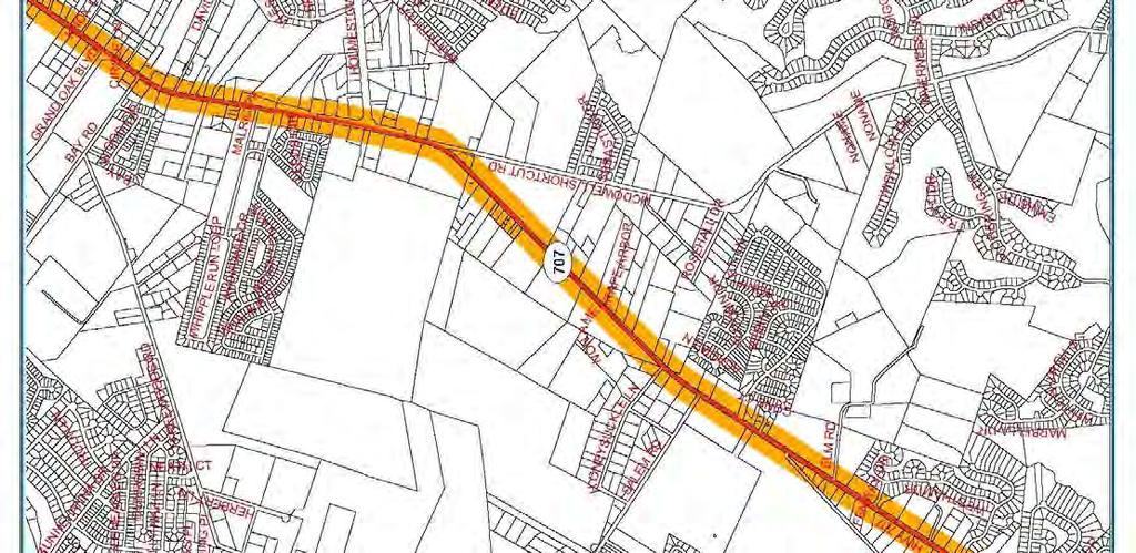
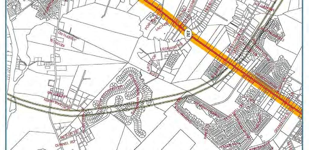
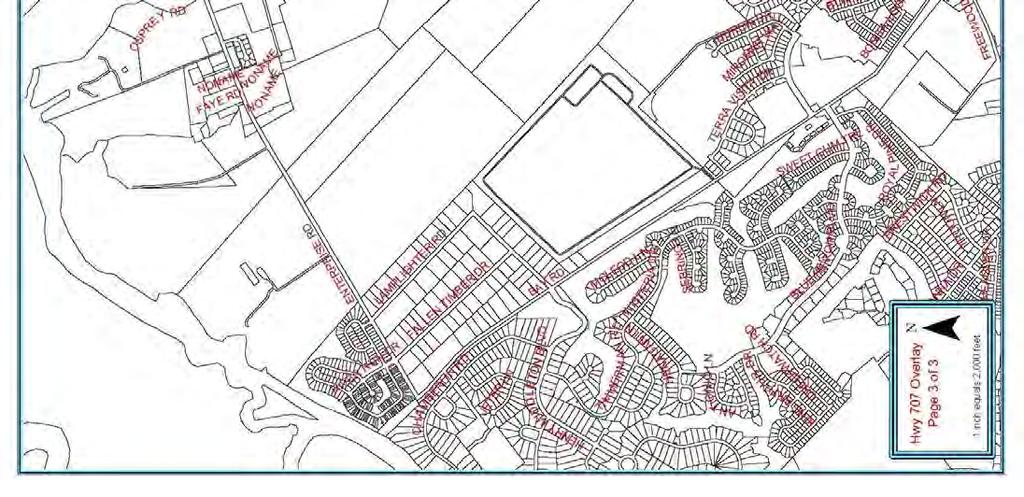
36 723.5 Highway 707 Overlay Zone (A) Purpose. The Highway 707 Overlay Zone is established to provide standards relative to accessibility, appearance, and safety in the development of commercial, industrial, multi-family residential, and office projects that utilize Highway 707 as their primary means of access. Furthermore, the overlay is established to provide unified development that promotes a sense of place and provides opportunities to develop projects engineered to be compatible with the carrying capacity of Highway 707 as a major urban corridor. When any existing county ordinance is amended, the more restrictive provisions of such revised ordinance shall apply even if these overlay zone standards are more relaxed. (B) Applicability. The Highway 707 Corridor Overlay Zone shall begin at the stoplight at the intersection of Highway 707 and Dick Pond Road or the old alignment of Highway 544 and travel south to the Georgetown County line. The existing Socastee Overlay Zone is located on the northern section of Highway 707 between Highway 17 Bypass and ends at the stoplight at the intersection of Highway 707 and Dick Pond Road or the old alignment of Highway 544 and should not be confused with this Highway 707 Overlay Zone. The Overlay shall extend two hundred (200) feet to either side of the right-of-way lines of Highway 707. Attachment 1 Highway 707 Overlay Zone provides the location of the boundaries of this overlay. Renovated or newly constructed commercial, industrial, multi-family residential, or office developments that are located partially or completely within the boundaries indicated above shall comply with the regulations established below. Construction or renovation not visible from the corridor and singlefamily development are exempt from these regulations. Construction or renovation of any buildings located beyond the 200-foot overlay boundary is exempt from these regulations. Any building that has any portion within the 200-foot overlay boundary shall comply with these regulations. Renovation is defined as: Work that modifies or expands a structure or business where the improvements are equal to or greater than forty percent (40%) of the properties assessed value or the value of the property as determined by an independent appraisal. Water, sewer, and electrical expenditures shall be included in the costs of improvements for any expansion or new construction. General maintenance and repair of any water, sewer, or electrical expenditures incurred in updating an existing structure where no new expansion will occur are exempt from the standards established below. If an existing business is damaged or destroyed due to an act of nature (flood, hurricane, tornado, etc.), or catastrophic event and is reconstructed within twelve (12) months of such damage or destruction, the standards contained herein shall not apply. This exemption, however, shall not relieve the property owner of having to meet applicable building or zoning regulations that may be in place at the time of reconstruction. Corridor and overlay are used interchangeably throughout these regulations. When referenced, it shall mean the area generally two hundred (200) feet to the east and west of the Highway 707 right-of-way lines between the established beginning and ending points indicated above. Developments partially located within this area, when visible, shall comply with the regulations.
37
38
39
40 (C) Required Reviews. Proposed developments or renovations, meeting the above definition shall be reviewed by the Building/Codes, Planning, and Zoning Departments before issuance of building permits. Development plans shall provide information relative to the site layout including building elevations, landscaping, signage, and utility location. Submitted plans shall comply with the Horry County Commercial Plan submittal requirements and contain enough detail to illustrate that the requirements of this ordinance have been meet. (D) Modification of design standards. The Board of Zoning Appeals may approve modification of the design requirements of the overlay zone. Requests for modification of the design standards shall be considered at the time development plans are submitted for review and shall comply with all submittal requirements established in Article 15 (Board of Zoning Appeals) of the zoning ordinance. (E) Development and design requirements. Development of specific uses in the Highway 707 Overlay Zone shall be consistent with the underlying zoning district. In addition to the requirements of the applicable underlying zoning district the following supplemental development regulations shall apply. (1) Buildings a. Roof mounted mechanical equipment visible from the corridor shall be enclosed or screened to ensure that such features are not visible. Enclosures and screens shall be compatible to the architectural style of the proposed building; b. No portion of a building visible from the traffic lanes of the corridor shall be treated with unadorned concrete masonry units or corrugated and/or sheet metal. Materials suitable for treating visible facades may include, but are not limited to, brick, glass, siding (vinyl or wood), split block, stone, or stucco; c. Shingles, metal standing seam, tile or other roofing materials with similar appropriate texture and appearance shall be utilized on roofs visible from the corridor. Flat roofs are not discouraged where they are appropriate to the design theme of the structure; d. Blank or uninterrupted building facades visible from the corridor shall be designed in a manner that reduces the building mass by breaking the façade into smaller segments. Design techniques that include repetitive features or similar architectural elements may be utilized to accomplish this. (2) Structure Heights Structures within the Highway 707 Overlay shall not exceed thirty-five (35) feet in height. The roof, copulas, spires, or other ornamental features are permitted to increase building height to fifty (50) feet, but the height of the living space can be no higher that thirty-five (35) feet. The height of steeples, bell towers, or spires of churches, synagogues, temples, or other places of worship may be increased up to seventy-five (75) feet in height. (3) Landscaping and buffer requirements
41 To promote a continuous and unified theme, improve the appearance of structures and provide protection to adjacent properties from the negative impacts of more intense development, the following standards shall apply. Acceptable plant species, maintenance standards, and sizes to meet the above requirements are listed in Section 527. a. Foundation Landscaping. Landscaping shall be provided around the foundation of structures visible from any public right-of-way, according to the formula and standards below: 1. Calculation of required landscaping: PR = L or W/ 3.0 Where: PR = number of plants required L or W = building length or width, in feet, visible from any public right-of-way 2. Required plant materials shall be located in a planting area adjacent to the building foundation. If the proposed building is to be accessed by vehicles through service doors and such doors are visible from a public right-of-way, the plant materials required for that length or width shall be exempted from these provisions. 3. For each canopy or understory tree that is provided to meet the foundation landscaping requirements the total number of required plants may be reduced by two. b. Perimeter landscaping. A landscape buffer shall be provided around the perimeter of any parcel that directly abuts the corridor. The buffer shall be twenty-five (25) feet along the corridor and be equal to the side and rear setbacks required for the underlying zoning district elsewhere on the site. No landscape buffer will be required on any part of a parcel that abuts wetlands. Additional landscaping requirements will not be required between parcels with the same zoning designation. Such buffer shall be improved in accordance with the standards below. 1. When any non-residential zoned properties being developed abut a residential zoned property, one of the following four options shall be installed along the sides or rear property lines which abuts that residential property within the perimeter buffer of the newly developed site: A 4-foot high berm can be installed; or 2-foot high berm can be installed along with three (3) feet of plantings; or Plant landscape material in a staggered planting scheme at a 5-foot height at the time of planting with no berm included; or A 6-foot wood fence.
42 No fence, berm, or landscape material shall be designed or located in a manner that obstructs the vision of vehicular traffic at street and/or driveway intersections. Any plantings installed above are required within five years to achieve summer season opacity factor of at least eighty percent (80%). Opacity is hereby defined as: The state of being impervious or impenetrable to the passage of light or allowing visual access to objects located behind natural or manmade features. The Zoning Administrator or designee shall inspect any suspected violations of the opacity standards specified herein at least three areas within required buffer area. Each area to be inspected will be an 8-foot length of the required vegetation screening from the ground to the average top height of the vegetation. An inspection estimate indicating twenty percent (20%) or less of light penetration or complete visual penetration will satisfy the eighty percent (80%) opacity factor. Any inspection estimate higher than twenty percent (20%) of light penetration or complete visual penetration will be considered to fail the eighty percent (80%) opacity factor. Any inspections that result in a failure will be reported to the property owner. Failure of that property owner to correct the situation within forty-five (45) days will constitute a violation of the zoning ordinance and be subject to the fines and penalties specified therein. When a new residential development is created adjacent to or abutting to an existing non-residential zoned property within the 200-foot corridor, it is the responsibility of that new residential development to create one of the four options of berms and/or vegetation planting listed above. When a berm is installed, it shall be improved in accordance with the standards indicated in (3) b.6, below. 2. The perimeter buffer shall be improved in the following manner: (a) Be planted with materials capable of survival in the environment in which they are installed with minimal maintenance; and (b) Complement the structure, through color and foliage cover, for which they are planted around; and (c) Include the following mixture of plant materials per one hundred (100) feet of buffer length: Three (3) canopy trees or palmetto trees, equally spaced; Three (3) understory trees that flower or have foliage that changes color seasonally, equally spaced Twenty (20) shrubs; and Eight (8) evergreens (may be tree or shrub variety)
43 3. Provide visual direction, through plant heights, to entrances or other access features to the site; and 4. Be planted in a manner that will not impede traffic safety by blocking or otherwise obstructing traffic signals, signs, or other devices. 5. When a natural, undisturbed buffer is retained along the corridor, sides and rear of a renovated or newly developed property a waiver of the required perimeter landscaping may be granted. The Zoning Administrator or designee upon review of a site plan identifying the vegetation retained in the buffers shall determine the granting of such waiver. When plants retained do not meet the required numbers of 2.(c), above, the Zoning Administrator or designee may give credit for what is retained and require that the buffer along the corridor, sides and rear of the property be supplemented by additional plant materials. Natural, undisturbed buffers meeting the following standards may qualify for the perimeter-landscaping waiver: A 25-foot buffer is retained along the corridor; and A 20-foot buffer is retained along the sides and rear of the parcel; and The plant materials retained shall, at a minimum, consist of trees 3 inches dbh (diameter at breast height) or greater along the corridor and other vegetation not less than three (3) feet in height or with caliper greater than 2 inches dbh along the sides and rear of the property. 6. Berm construction requirements. When a berm is utilized to provide separation between non-similarly zoned properties or to modify standards required elsewhere by these regulations, it shall adhere to the following: (a) Have side slopes no greater than 2:1; and (b) Be vegetated with the plant materials indicated in 2.c, above, (applies when berm is used between non-similarly zoned properties); and (c) Non-vegetated areas on the berm shall be covered with a groundcover, mulch, or grass suitable to stabilize the side slopes of the berm (used when modifying parking lot location) that will result in the berm obtaining a finished height of no less than three (3) feet. (d) Breaks in the berm may be permitted every six (6) to eight (8) feet where situations exist to allow for necessary site drainage. 7. Drainage and utility encroachment into the perimeter buffer Ditches, swales, stormwater conveyance facilities, stormwater retention ponds, sanitary sewer conveyance facilities, and associated easements may encroach up to 10% into the buffer area or a required screening berm. When a drainage or utility encroachment requires more than the ten percent (10%) reduction allotted, a request for increased encroachment may be submitted to the Board of Zoning Appeals for
44 consideration. Such request shall be submitted when the development site plan is submitted for review. (4) Leasing, rental, or sale facilities a. Businesses engaged in the leasing, rental, or sale of merchandise that have frontage along the corridor shall adhere to the landscaping and buffer requirements indicated above, and provisions below. Display lots associated with such businesses are exempt from the parking area requirements. b. Each business shall be permitted one display pad, no larger then two hundred (200) square feet, for merchandise sold at such establishment. An additional display pad shall be permitted for each two hundred (200) feet of corridor frontage. The display pad shall be located behind the required perimeter buffer and may be elevated a maximum of eighteen (18) inches above finished grade. c. Merchandise shall not be permitted to be temporary or permanently placed or parked within the front buffer. (5) Shipping/receiving areas and utility location a. Proposed structures, visible from the corridor, requiring shipping docks for the receipt or shipping of merchandise shall locate such docks in the rear of the structure or within a service courtyard shared by different businesses. Shared courtyards may be accessed from the front of the structure provided the entrance to such area is designed to blend into the architectural style of the structure and no docks are visible from the corridor or adjacent parking areas. b. Utility services shall be located underground when possible. If underground utility location is not possible, above grade utilities shall be located behind structures in a utility "alley" easement approved by the applicable utility authority. (6) Salvage yards, automobile repair facilities, and mini-warehouses Businesses engaged in salvage operations, repair of automobiles, or storage of possessions in individually enclosed units/garages that have frontage along the corridor shall adhere to the landscaping and buffer standards provided in (3)b. above, and the following: a. Storage areas for salvaged materials or vehicles waiting for repair shall be screened from the corridor by a six foot high opaque enclosure or equal to the height of the stored material not to be higher than twenty (20) feet which shall be located to the rear or side of the primary structure on the site; and b. A 10-foot wide landscaped buffer shall be provided around the base of the enclosure to soften its appearance. Landscaping utilized shall be consistent with that required in (3)b.2, above.
45 c. A 6-foot solid or opaque fence will be required around any storage of recreational vehicles and mini-storage units. (7) Access management To ensure that development within the corridor does not impact the carrying capacity or future improvement of Highway 707, the following access management strategies shall be employed. a. Parcel Access 1. Every property owner will be allowed access to Highway 707 from their property. Shared driveways are encouraged. Additional access points may be permitted provided their location and design adheres to the SCDOT Access and Roadside Management Standards. A copy of the encroachment permit shall be provided at the time plans are submitted for review. 2. Parcels located at an intersection of Highway 707 and another improved public roadway shall obtain access from the adjacent public roadway. Direct access to the corridor may be permitted when the parcel has two hundred (200) or more feet of corridor frontage, the access is no closer than two hundred (200) feet to another access, and the access is approved by SCDOT. 3. When applicable, access to a parcel shall be aligned directly with existing median crossovers. Accesses that do not align directly shall be located a minimum of one hundred (100) feet (edge to edge) from the nearest crossover. b. Consolidation of access points Reduction of access points to the corridor are encouraged due to the increases in operational efficiency that result. When any of the following strategies are used, participating businesses shall be entitled to the variations listed below. 1. Shared or joint access. Use of shared or joint access between two or more properties shall allow required parking for the adjacent uses to be reduced up to twenty-five percent (25%). 2. Cross-access easements. Use of cross-access easements between properties resulting in access to parcels being restricted to existing median crossovers shall be entitled the following: (a) Required parking for adjacent uses shall be reduced up to twenty-five percent (25%). c. Parking lot access. Parking lots that directly access the corridor or a frontage roadway shall: 1. Be designed to ensure that entering vehicles maintain a travel speed of 15 mph to assist in reducing interference with through street traffic movements.
46 2. Setback required landscaping or optional berming to ensure that a sight triangle, conforming to SCDOT standards, exists. (8) Parking areas To reduce the visual mass and enhance the appearance of parking areas from the corridor, a perimeter buffer of twenty-five (25) feet along the corridor and equal to side and rear setbacks of the underlying zoning district shall be installed and improved with landscape materials specified in (3)b above. Display lots used in connection with businesses engaged in the sale, lease or rental of merchandise are exempt from the following standards; however; shall be required to comply with the landscaping and buffer requirements of (3)b above. a. Parking lots shall be distributed around the front or sides of proposed structures and outside the perimeter buffer as required in (3)b above unless the requirements of item #c, below, are met. Parking may be located behind the proposed structure if desired. b. Parking areas shall be screened from the corridor. Screening may be accomplished in any of the following ways: 1. Through retention of the natural vegetation within the perimeter buffer provided such vegetation is consistent with the requirements of (3)b.5 above; or 2. Through the placement of landscaping in the perimeter buffer that is consistent with the material requirements of(3)b.2; or 3. Through the placement of a berm no less than two feet in height and planted with a stabilizing ground cover or plant materials resulting in a total height of 3-feet. c. Parking spaces may encroach into the buffer area provided such parking is no closer than ten (10) feet from the property line and the landscape materials not installed as a result of moving the parking into the buffer area are redistributed throughout the site. The remaining buffer area between the parking spaces and the property line shall be improved with landscaping consistent with the requirements of (3)b.2 or a two-foot high berm that is improved as required in (3)b.6. d. Parking areas shall be designed so that no one parking module contains more than 150 spaces. Parking within modules shall be grouped so that 9 x 15 parking islands are provided for every twenty (20) parking spaces in a continuous row or for a maximum of forty (40) spaces per bay between parking islands. Parking islands shall be surrounded by curbing to prevent vehicular intrusion and improved with at least one 2-½ inch caliper canopy tree to reduce parking lot heat and glare. The remaining area of the parking island shall be planted with vegetation that complements the structure or a suitable groundcover. e. Parking areas containing more than one hundred fifty (150) spaces, in addition to the meeting the requirements, above, shall also provide a 10-foot landscaped island
47 between each parking module. Landscaping placed within such islands shall be sufficient to provide visual relief from the mass of the parking area. f. Parking areas shall be lit to provide safety for the patrons utilizing the lot and shall have their height restricted as follows: 1. Parking lot lighting in both the Highway 707 Overlay Zone shall have lighting no greater than twenty-five (25) feet in height; and 2. New businesses, which can justify to the Zoning Administrator or their designee, their need to install parking lot lighting higher than twenty-five (25) feet, may be exempt from this restriction; and 3. Lighting required for special events will be exempt from this ordinance; and 4. All lighting shall be directed to ensure no spillover lighting occurs on adjacent properties or public rights-of-way and shall not cause illumination in excess of one (1) foot candle across any residential lot line in any residential district. g. Parking space reductions. The number of required parking spaces may be reduced under the following conditions: 1. The reduction is no greater than fifteen (15) percent of the total parking required for the proposed use; and 2. The perimeter buffer is increased to thirty-five (35) feet and the required landscaping is increased at a rate of twenty-five (25) percent of that required in (3)b.2; or 3. Parking islands are provided for every fifteen (15) parking spaces in a continuous row or for a maximum of thirty (30) spaces per bay between parking islands. Such islands shall be improved as specified, above. (9) Signage. a. On-site signage requirements. To reduce "overload" and sign clutter in the corridor, the following standards shall apply to on-site signage. 1. Properties with 400 feet of corridor frontage shall be permitted one 35-foot tall freestanding primary identification sign. For each additional 400 feet of corridor frontage, an additional identification sign, 25 feet in height, shall be permitted. In no instance shall a site have more than three on-site freestanding signs. 2. Individual parcels with between 200 and 400 feet of corridor frontage shall be permitted one freestanding sign, 25 feet in height. Individual parcels with less than 200 feet of corridor frontage shall be limited to one 8-foot high monument-style sign from finished grade. 3. When a site s primary or secondary access is from a roadway other than the corridor, one identification sign, 25 feet in height, for every 400 feet of roadway frontage shall be permitted.
48 4. Freestanding and monument-style sign area (advertising area) shall be determined by the amount of frontage the parcel has on the corridor. The sign area shall equal 1 square foot or portions thereof rounded up to the nearest one square foot of sign area for every one-foot of roadway frontage. In no case shall total sign area on a site exceed 400 square feet. For any site that has more than one sign as addressed in a above, the total combined sign area for all of the signs shall not exceed 400 square feet. For small odd shaped parcels or lots with unique situations, a minimum of 50 square feet of sign area will be allowed. 5. Freestanding and monument-style signage shall be architecturally designed to reflect the character of the structure for which they are advertising. 6. Animated signs or signs with flashing lights are prohibited in the corridor, except that time temperature boards, and light emitting diode (LED) displays shall be allowed. 7. Internal illumination of freestanding sign shall be required. Monument style-signage may be externally lit provided the illumination source is shielded from the corridor. When internal illumination of freestanding signs is not possible, the Zoning Administrator may permit external illumination.
49 8. Signage Allowed by Property Type and Corridor Frontage Type of Property 1 Freestanding single parcel Freestanding single parcel More than 400 feet or portion thereof up to Freestanding Single 799 feet parcel Each additional 400 feet of frontage More than 400 feet or portion thereof up to Commercial Center feet Each additional 400 Out-parcel that is part of a commercial center 5 Length of Corridor Number Type of Sign Height 3 Sign Area Frontage of Signs 2 Computation 4 Less than 200 feet 1 Monument 8 feet feet 1 Freestanding 25 feet Freestanding "primary" 1 (max. 2) 1 - Freestanding "secondary" Freestanding "primary" 35 feet 25 feet 35 feet 1 (max. 2) 1 - Freestanding 25 feet feet of frontage "secondary" Less than 400 feet 1 Monument 8 feet 1 sq. ft. for every 1 linear foot of frontage not to exceed 400 sq. ft. Notes: 1. When a site's primary or secondary access is from a roadway other than the corridor, one identification sign, 25 feet in height, for every 400 feet of roadway frontage shall be permitted. 2. In no instance shall a site have more than three (3) freestanding signs. 3. Sign height shall be measured from finished grade. 4. Maximum sign area per site shall be no greater than 750 sq.ft. Out-parcels of a commercial center, as defined below, shall not be counted as part of the commercial center maximum sign area. 5. Out-parcels located on the corner of property within a commercial center shall be permitted two 8-foot high monument-style signs, one on each roadway frontage. 6. Signage on parcels improved with commercial centers, as defined below, shall be calculated based on the total roadway frontage that such parcel has inclusive of any out-parcels that may be part of the commercial center. Signage for out-parcels that are part of a commercial center shall be calculated as shown in the above table. A Commercial Center is defined as a development where more than two (2) businesses are located in a single structure and where there may be additional detached structures on the property that are on out-parcels, leased or owned fee-simple. b. Off-premise advertising signage No new or additional off-premise signs will be allowed or permitted in the defined area of the corridor overlay zone.
50 723.6 Holmestown Road Overlay Zone (A) Purpose. The Holmestown Road Overlay Zone is established to provide standards relative to accessibility, appearance and safety in the development of commercial, industrial, multi-family residential and office projects that utilize Holmestown Road as their primary means of access. Furthermore, the overlay is established to provide unified development that promotes a sense of place and provides opportunities to develop projects engineered to be compatible with the carrying capacity of Holmestown, a major urban corridor. In the event that, any existing county ordinance is amended, the more restrictive provisions of such revised ordinance shall apply even if these overlay zone standards are more relaxed. (B) Applicability. The Holmestown Road Corridor Overlay Zone shall begin at the stoplight at the intersection of Highway 707 and Holmestown Road (SC #1240) and travel east until Holmestown Road ends at the stoplight and the intersection of Highway 17 Bypass and Holmestown Road. The Overlay shall extend 200 feet to either side of the right-of-way lines of Holmestown Road as shown in Attachment 1 Holmestown Road Overlay. Renovated or newly constructed commercial, industrial, multi-family residential, or office developments that are located partially or completely within the boundaries indicated above shall comply with the regulations established below. Construction or renovation not visible from the corridor and singlefamily development are exempt from these regulations. Renovation is defined as: Work that modifies or expands a structure or business where the improvements are equal to or greater than 40% of the properties assessed value or the value of the property as determined by an independent appraisal. Water, sewer, or electrical expenditures shall be included in the costs of improvements for any expansion or new construction. General maintenance and repair of any water, sewer, or electrical expenditures incurred in updating an existing structure where no new expansion will occur are exempt from the standards established below. If an existing business is damaged or destroyed due to an act of nature (flood, hurricane, tornado, etc.), or catastrophic event and is reconstructed within 12 months of such damage or destruction, the standards contained herein shall not apply. This exemption, however, shall not relieve the property owner of having to meet applicable building or zoning regulations that may be in place at the time of reconstruction. Corridor and overlay are used interchangeably throughout these regulations. When referenced, it shall mean the area generally 200 feet to the north and south of the Holmestown Road right-of-way lines between the established beginning and ending points indicated above. Developments partially located within this area, when visible, shall comply with the regulations.
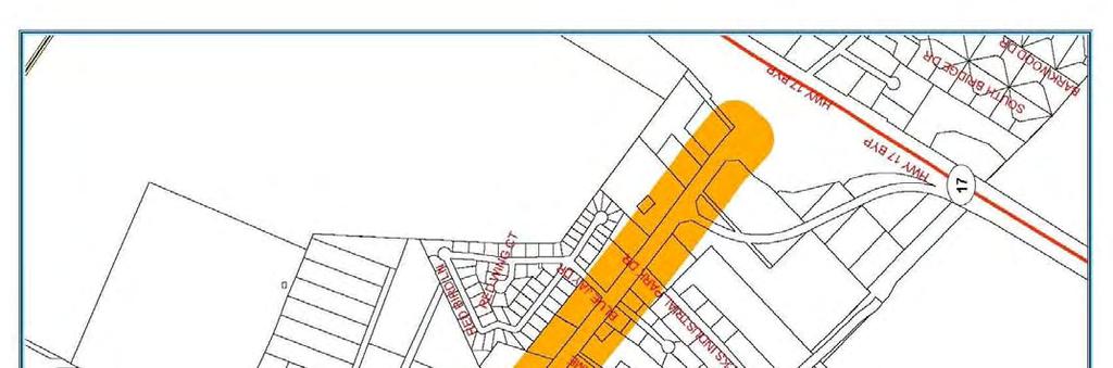
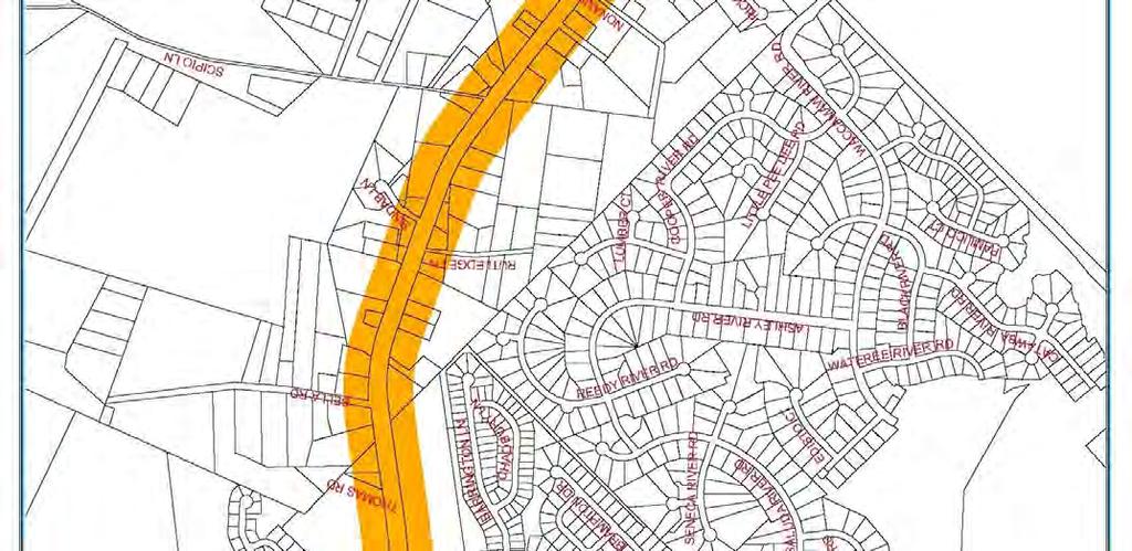
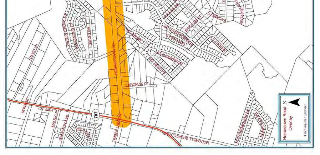
51
52 (C) Required Reviews. Proposed developments or renovations, meeting the above definition shall be reviewed by the Code Enforcement and Planning, and Zoning Departments before issuance of building permits. Development plans shall provide information relative to the site layout including building elevations, landscaping, signage, and utility location. Submitted plans shall comply with the Horry County Commercial Plan submittal requirements and contain enough detail to illustrate that the requirements of this ordinance have been meet. (D) Modification of design standards. The Board of Zoning Appeals may approve modification of the design requirements of the overlay zone. Requests for modification of the design standards shall be considered at the time development plans are submitted for review and shall comply with all submittal requirements established in the zoning ordinance. (E) Development and design requirements. Development of specific uses in the Holmestown Road Overlay Zone shall be consistent with the underlying zoning district. In addition to the requirements of the applicable underlying zoning district the following supplemental development regulations shall apply. (1) Buildings a. Roof mounted mechanical equipment visible from the corridor shall be enclosed or screened to ensure that such features are not visible. Enclosures and screens shall be compatible to the architectural style of the proposed building; b. No portion of a building visible from the corridor shall be treated with unadorned concrete masonry units or corrugated and/or sheet metal. Materials suitable for treating visible facades may include, but are not limited to, brick, glass, siding (vinyl or wood), split block, stone, or stucco; c. Shingles, metal standing seam, tile or other roofing materials with similar appropriate texture and appearance shall be utilized on roofs visible from the corridor. Flat roofs can be used when they are appropriate to the design theme of the structure; d. Blank or uninterrupted building facades visible from the corridor shall be designed in a manner that reduces the building mass by breaking the façade into smaller segments. Design techniques that include repetitive features or similar architectural elements may be utilized to accomplish this. (2) Structure Heights Structures within the Holmestown Road Overlay Zone shall not exceed thirty-five (35) feet in height as defined in the zoning ordinance. The roof, copulas, spires, or other ornamental features are permitted to increase building height to fifty (50) feet, but the height of the living space can be no higher that thirty-five (35) feet. The height of steeples, bell towers, or spires of churches, synagogues, temples, or other places of worship may be increased up to seventy-five (75) feet in height.
53 (3) Landscaping and buffer requirements To promote a continuous and unified theme, improve the appearance of structures and provide protection to adjacent properties from the negative impacts of more intense development, the following standards shall apply. Acceptable plant species, maintenance standards, and sizes to meet the above requirements are listed in Section 527. a. Foundation Landscaping. Landscaping shall be provided around the foundation of structures visible from any public right-of-way, according to the formula and standards below: 1. Calculation of required landscaping: PR = L or W/ 3.0 Where: PR = number of plants required L or W = building length or width, in feet, visible from any public right-of-way 2. Required plant materials shall be located in a planting area adjacent to the building foundation. If the proposed building is to be accessed by vehicles through service doors and such doors are visible from a public right-of-way, the plant materials required for that length or width shall be exempted from these provisions. 3. For each canopy or understory tree that is provided to meet the foundation landscaping requirements the total number of required plants may be reduced by two (2). b. Perimeter landscaping. A landscape buffer shall be provided around the perimeter of any parcel that directly abuts the corridor. The buffer shall be 25 feet along the corridor and be equal to the side and rear setbacks required for the underlying zoning district elsewhere on the site. No landscape buffer will be required on any part of a parcel that abuts wetlands. Additional landscaping requirements will not be required between parcels with the same zoning designation. Such buffer shall be improved in accordance with the standards below. 1. When any non-residential zoned properties being developed abut a residential zoned property, one of the following four options shall be installed along the sides or rear property lines which abuts that residential property: A 4-foot high berm can be installed; or A 2-foot high berm can be installed along with 3 feet of plantings; or Plant landscape material in a staggered planting scheme at a 5 foot height at the time of planting with no berm included; or A 6-foot wood fence.
54 No fence, berm, or landscape material shall be designed or located where it obstructs the vision of vehicular traffic at street and/or driveway intersections. Any plantings installed for the above purposes are required to achieve summer season opacity factor of at least 80% within five years. Opacity is hereby defined as the state of being impervious or impenetrable to the passage of light or allowing visual access to objects located behind natural or man-made features. The Zoning Administrator or designee shall inspect any suspected violations of the opacity standards specified herein at least three (3) areas within required buffer area. Each area to be inspected will be an eight (8)foot length of the required vegetation screening from the ground to the average top height of the vegetation. An inspection estimate indicating 20% or less of light penetration or complete visual penetration will satisfy the 80% opacity factor. Any inspection estimate higher than 20% of light penetration or complete visual penetration will be considered to fail the 80% opacity factor. Any inspections that result in a failure will be reported to the property owner. Failure of that property owner to correct the situation within 45 days will constitute a violation of the zoning ordinance and be subject to the fines and penalties specified therein. When a new residential development is created adjacent to or abutting to an existing non-residential zoned property within the 300-foot corridor, it is the responsibility of that new residential development to create one of the four options of berms and/or vegetation planting listed above. 2. The perimeter buffer shall be improved in the following manner: (a) Be planted with materials capable of survival in the environment in which they are installed with minimal maintenance; (b) Complement the structure, through color and foliage cover, for which they are planted around; (c) Include the following mixture of plant materials per 100 feet of buffer length: 3 canopy trees or palmetto trees, equally spaced; 3 understory trees that flower or have foliage that changes color seasonally, equally spaced 20 shrubs; and 8 evergreens (may be tree or shrub variety) 3. Provide visual direction, through plant heights, to entrances or other access features to the site; 4. Be planted in a manner that does not impede traffic safety by blocking or obstructing traffic signals, signs, or other devices.
55 5. When a natural, undisturbed buffer is retained along the corridor, sides and rear of a renovated or newly developed property, a waiver of the required perimeter landscaping may be granted. Granting such waiver shall be determined by the Zoning Administrator or designee upon review of a site plan identifying the vegetation retained in the buffers. In no instance, shall a waiver be granted if the plants retained in the buffers are not equal, in number not plant type, to those required in item # 3, above. When plants retained do not meet the required numbers of item # 3, above, the Zoning Administrator or designee may give credit for what is retained and require that the buffer along the corridor, sides and rear of the property be supplemented by additional plant materials. Natural, undisturbed buffers meeting the following standards may qualify for the perimeter-landscaping waiver: A 25-foot buffer is retained along the corridor; A 20-foot buffer is retained along the sides and rear of the parcel; The plant materials retained shall, at a minimum, consist of trees three (3) inches dbh (diameter at breast height) or greater along the corridor and other vegetation not less than three (3) feet in height or with caliper greater than two (2) inches dbh along the sides and rear of the property. c. Berm construction requirements. When a berm is utilized to provide separation between non-similarly zoned properties or to modify standards required elsewhere by these regulations, it shall adhere to the following: 1. Have side slopes no greater than a 2:1ratio; 2. Be vegetated with the plant materials indicated in (3)b.2 above, above, (applies when berm is used between non-similarly zoned properties); 3. Non-vegetated areas on the berm shall be covered with a groundcover, mulch, or grass suitable to stabilize the side slopes of the berm (used when modifying parking lot location) that will result in the berm obtaining a finished height of no less than three (3)feet. 4. Breaks in the berm may be permitted every six (6) to eight (8) feet where situations exist to allow for necessary site drainage. d. Drainage and utility encroachment into the perimeter buffer Ditches, swales, stormwater conveyance facilities, stormwater retention ponds, sanitary sewer conveyance facilities, and associated easements may encroach up to ten (10) percent into the buffer area or a required screening berm. When a drainage or utility encroachment requires more than the ten (10) percent reduction allotted, a request for increased encroachment may be submitted to the Board of Zoning Appeals for consideration. Such request shall be submitted when the development site plan is submitted for review.
56 (4) Leasing, rental, or sale facilities Businesses engaged in the leasing, rental, or sale of merchandise that have frontage along the corridor shall adhere to the landscaping and buffer requirements indicated in (3)b, above, and provisions below. Display lots associated with such businesses are exempt from the parking area requirements, above. a. Each business shall be permitted one display pad, no larger then 200 square feet, for merchandise sold at such establishment. An additional display pad shall be permitted for each 200 feet of corridor frontage. The display pad shall be located behind the required perimeter buffer and may be elevated a maximum of 18 inches above finished grade. b. Merchandise shall not be permitted to be temporary or permanently placed or parked within the front buffer. (5) Shipping/receiving areas and utility location a. Proposed structures, visible from the corridor, requiring shipping docks for the receipt or shipping of merchandise shall locate such docks in the rear of the structure or within a shared service courtyard. Shared courtyards may be accessed from the front of the structure provided the entrance to such area is designed to blend into the architectural style of the structure and no docks are visible from the corridor or adjacent parking areas. b. Utility services shall be located underground when possible. If underground utility location is not possible, above grade utilities shall be located behind structures in a utility easement approved by the applicable utility authority (6) Salvage yards, automobile repair facilities, and mini-warehouses Businesses engaged in salvage operations, repair of automobiles, or storage of possessions in individually enclosed units/garages that have frontage along the corridor shall adhere to the landscaping and buffer standards provided above, and the following: a. Storage areas for salvaged materials or vehicles waiting for repair shall be screened from the corridor by a six (6) foot high opaque enclosure or equal to the height of the stored material not to be higher than 20 feet which shall be located to the rear or side of the primary structure on the site; and b. A ten (10) foot wide landscaped buffer shall be provided around the base of the enclosure to soften its appearance. Landscaping utilized shall be consistent with that required in (3)b.2, above. c. A six (6) foot solid or opaque fence will be required around any storage of recreational vehicles and mini-storage units. (7) Access management
57 To ensure that development within the corridor does not impact the carrying capacity or future improvement of Holmestown Road, the following access management strategies shall be employed. a. Parcel Access 1. Every property owner will be allowed access to Holmestown Road from their property. Shared driveways are encouraged. Additional access points may be permitted provided their location and design adheres to the SCDOT Access and Roadside Management Standards. A copy of the encroachment permit shall be provided at the time plans are submitted for review. 2. Parcels located at an intersection of Holmestown Road and another improved public roadway shall obtain access from the adjacent public roadway. Direct access to the corridor may be permitted when the parcel has 200 or more feet of corridor frontage, the access is no closer than 200 feet to another access, and the access is approved by SCDOT. 3. When applicable, access to a parcel shall be aligned directly with existing median crossovers. Accesses that do not align directly shall be located a minimum of 100 feet (edge to edge) from the nearest crossover. b. Consolidation of access points Reduction of access points to the corridor are encouraged due to the increases in operational efficiency that result from limited access. When any of the following strategies are used, participating businesses shall be entitled to the incentives listed below. 1. Shared or joint access. Use of shared or joint access between two or more properties shall allow required parking for the adjacent uses to be reduced up to 25%. 2. Cross-access easements. Use of cross-access easements between properties resulting in access to parcels being restricted to existing median crossovers may reduce their parking up to 25 %. c. Parking lot access Parking lots that directly access the corridor or a frontage roadway shall: 1. Be designed to ensure that entering vehicles maintain a travel speed of 15 mph. The accesses should be design in order to reduce interference with through street traffic movements. 2. Provide an entrance drive throat length of no less than 100 feet to reduce conflicts between entering and exiting vehicles. Developments that generate less than 500 ADTs shall be exempt from this standard.
58 3. Place required landscaping or optional earthen berms outside required site triangles. (8) Parking areas To enhance the appearance of parking areas from the corridor, a perimeter buffer of twenty-five (25) feet along the corridor and equal to side and rear setbacks of the underlying zoning district shall be installed and improved with landscape materials specified in (3)b above. Display lots used in connection with businesses engaged in the sale, lease, or rental of merchandise are exempt from the following standards. However, display lots shall be required to comply with the landscaping and buffer requirements of (3)b above. a. Parking lots shall be distributed around the front or sides of proposed structures and outside the perimeter buffer as required in (3)b.2 above unless the requirements of item # c, below, are met. Parking may be located behind the proposed structure if desired. b. Parking areas shall be screened from the corridor. Screening may be accomplished in any of the following ways: 1. Through retention of the natural vegetation within the perimeter buffer provided such vegetation is consistent with the requirements of (3)b.5 above; or 2. Through the placement of landscaping in the perimeter buffer that is consistent with the material requirements of (3)b.2 above; or 3. Through the placement of a berm no less than two (2) feet in height and planted with a stabilizing ground cover or plant materials resulting in a total height of three (3) feet. c. Parking spaces may encroach into the buffer area provided such parking is no closer than ten (10) feet from the property line. If parking is located in the buffer, the landscape materials not installed as a result of moving the parking into the buffer shall be redistributed throughout the site. The remaining buffer area between the parking spaces and the property line shall be improved with landscaping consistent with the requirements of (3)b.2 above or a two (2) foot high berm that is improved as required. d. Parking areas shall be designed so that no one parking module contains more than 150 spaces. Parking within modules shall be grouped so that 9 x 15 parking islands are provided for every 20 parking spaces in a continuous row or for a maximum of 40 spaces per bay between parking islands. Parking islands shall be surrounded by curbing to prevent vehicular intrusion and improved with at least one 2-½ inch caliper canopy tree to reduce parking lot heat and glare. The remaining area of the parking island shall be planted with vegetation that complements the structure or a suitable groundcover.
59 e. Parking areas containing more than 150 spaces must meet the requirements of paragraph 4, above and shall also provide a 10-foot landscaped island between each parking module. Landscaping placed within such islands shall be sufficient to provide visual relief from the mass of the parking area. f. Parking areas shall be lit to provide safety for the patrons utilizing the lot and shall have their height restricted as follows: 1. Parking lot lighting in the Holmestown Road Overlay Zone shall have lighting no greater than 25 feet in height; 2. New businesses, which can justify to the Zoning Administrator or their designee, their need to install parking lot lighting higher than 25 feet, may be exempt from this restriction; 3. Lighting required for special events will be exempt from this ordinance; and 4. All lighting shall be directed to ensure no spillover lighting occurs on adjacent properties or public rights-of-way and shall not cause illumination in excess of one (1) foot candle across any residential lot line in any residential district. g. Parking Space Reductions The number of parking spaces required of the Horry County Zoning Ordinance, may be reduced under the following conditions: 1. The reduction is no greater than fifteen (15) percent of the total parking required for the proposed use; 2. The perimeter buffer is increased to thirty-five (35) feet and the required landscaping is increased at a rate of twenty-five (25) percent of that required in (3)b.2 above; 3. Parking islands are provided for every 15 parking spaces in a continuous row or for a maximum of 30 spaces per bay between parking islands. Such islands shall be improved as specified above. (9) Signage a. On-site signage requirements 1. Properties with 400 feet of corridor frontage shall be permitted one 35-foot tall freestanding primary identification sign. For each additional 400 feet of corridor frontage, an additional identification sign, 25 feet in height, shall be permitted. In no instance shall a site have more than three on-site freestanding signs. 2. Individual parcels with between 200 and 400 feet of corridor frontage shall be permitted one freestanding sign, 25 feet in height. Individual parcels with less than 200 feet of corridor frontage shall be limited to one 8-foot high monumentstyle sign from finished grade.
60 3. When a site s primary or secondary access is from a roadway other than the corridor, one identification sign, 25 feet in height, for every 400 feet of roadway frontage shall be permitted. Notwithstanding item a above, the total number of on-site freestanding signs shall not exceed three. 4. Freestanding and monument-style sign area (advertising area) shall be determined by the amount of frontage the parcel has on the corridor. The sign area shall equal one (1) square foot or portions thereof rounded up to the nearest one square foot of sign area for every one (1) foot of roadway frontage. In no case shall total sign area on a site exceed 400 square feet. For any site that has more than one sign as addressed in a above, the total combined sign area for all of the signs shall not exceed 400 square feet. For small odd shaped parcels or lots with unique situations, a minimum of fifty (50) square feet of sign area will be allowed. 5. Freestanding and monument-style signage shall be architecturally designed to reflect the character of the structure for which they are advertising. 6. Animated signs or signs with flashing lights are prohibited in the corridor, except that time temperature boards, and light emitting diode (LED) displays shall be allowed. 7. Internal illumination of freestanding sign shall be required. Monument stylesignage may be externally lit provided the illumination source is shielded from the corridor. When internal illumination of freestanding signs is not possible, the Zoning Administrator may permit external illumination. 8. Signage Allowed by Property Type and Corridor Frontage Type of Property 1 Freestanding single parcel Freestanding single parcel Freestanding Single parcel Commercial Center 6 Out-parcel that is part of a commercial center 5 Length of Corridor Number Type of Sign Height 3 Sign Area Frontage of Signs 2 Computation 4 Less than 200 feet 1 Monument 8 feet feet 1 Freestanding 25 feet More than 400 feet or portion thereof up to 799 feet Each additional 400 feet of frontage More than 400 feet or portion thereof up to 799 feet Each additional 400 feet of frontage Freestanding "primary" 1 (max. 2) 1 - Freestanding "secondary" Freestanding "primary" 1 (max. 2) 1 - Freestanding "secondary" 35 feet 25 feet 35 feet 25 feet Less than 400 feet 1 Monument 8 feet 1 sq. ft. for every 1 linear foot of frontage not to exceed 400 sq. ft.
61 Notes: 1. When a site's primary or secondary access is from a roadway other than the corridor, one identification sign, 25 feet in height, for every 400 feet of roadway frontage shall be permitted. 2. In no instance shall a site have more than three (3) freestanding signs. 3. Sign height shall be measured from finished grade. 4. Maximum sign area per site shall be no greater than 750 sq.ft. Out-parcels of a commercial center, as defined below, shall not be counted as part of the commercial center maximum sign area. 5. Out-parcels located on the corner of property within a commercial center shall be permitted two 8-foot high monument-style signs, one on each roadway frontage. 6. Signage on parcels improved with commercial centers, as defined below, shall be calculated based on the total roadway frontage that such parcel has inclusive of any out-parcels that may be part of the commercial center. Signage for out-parcels that are part of a commercial center shall be calculated as shown in the above table. A Commercial Center is defined as a development where more than two (2) businesses are located in a single structure and where there may be additional detached structures on the property that are on out-parcels, leased or owned fee-simple. (F) Off-premise advertising signage No new or additional off-premise signs will be allowed or permitted in the defined area of the corridor overlay zone.
62 723.7 Little River Overlay Zone (A) Purpose. (1) The Overlay Zone is established to provide standards relative to accessibility, appearance and safety in the development of commercial, industrial, multi-family residential and office projects. Furthermore, the overlay established to provide unified development that promotes a sense of place and provides opportunities to develop projects to be compatible with the carrying capacity of an urban corridor. (2) When any existing County ordinance is amended, the more restrictive provisions of such revised ordinance shall apply even if these Overlay Zone standards are less restrictive. (3) The following standards provide the minimum requirement that must be met in order to receive Planning Department/Commission authorization to develop or redevelop property with the Overlay Zone as established by the Zoning Ordinance. (4) The standards established herein address only site plan or design-related issues encountered in the development or redevelopment of property within the Overlay Zone. Specific zoning-related standards are established in the Zoning Ordinance and must also be met prior to beginning development or redevelopment activities in the Overlay Zone. (B) Applicability. (1) The boundaries of the Overlay Zone are established herein. The standards that follow shall be applicable to any substantially modified or newly constructed commercial, industrial, multi-family residential or office developments that is located partially or completely within the boundaries established within the Boundaries section of this ordinance. Construction or renovation that is interior to the structure is exempt from these regulations. (2) General maintenance and repair of any water, sewer, or electrical expenditures incurred in updating an existing structure where no new expansion will occur are exempt from the standards established below. (3) Any building that is partially located within the 250 feet, shall comply with these regulations. If an existing business is damaged or destroyed due to an act of nature (flood, hurricane, tornado, etc.), or catastrophic event and the building permit is acquired within twelve (12) months and is reconstructed within 24 months of such damage or destruction, the standards contained herein shall not apply. This exemption, however, shall not relieve the property owner of having to meet applicable building or zoning regulations that may be in place at the time of reconstruction. (C) Boundaries. (1) Corridor and overlay are used interchangeably throughout these regulations. When referenced, it shall mean the area generally 250 feet to the east and west of the Highway 17 right-of-way lines between the established beginning and ending points specified in this section of the Zoning Ordinance. (2) The Overlay zone shall begin at the North and South Carolina State Line and travel south to the overpass of HWY 90 at the Intersection HWY 9 and HWY 17. (3) Attachment 1 provides the location of the boundaries of this overlay. (next page) (D) Definitions.
63 (1) New Development means the construction of a building upon a vacant parcel; construction of a building upon a parcel whereon a building existed as of the effective date of this Ordinance and such building was razed; or the construction, alteration, modification of a building which involves the complete demolition of said building. (2) Substantial Modification means any improvement, expansion, renovation, alteration, construction or modification of a building or accessory structure existing as of the effective date of this Ordinance in which said improvement, expansion, renovation, alteration, construction or modification: a. Results in greater than a twenty-five percent (25%) increase in the total square footage of the existing building and accessory structure footprint; b. Results in an improvement, renovation, alteration, construction or modification where the cost of the proposed improvements is greater than twenty-five percent (25%) of the assessed value of the existing improvements. For purposes of this paragraph, assessed value shall be as determined by the Horry County Property Appraiser and costs of the proposed improvements shall be approved by the Building Official; or c. Results in greater than a one hundred percent (100%) increase in the number of existing paved parking spaces, as required and in compliance with this Ordinance, due to a change in the use of the subject property when compared to the existing number of paved parking spaces for the prior use of the subject property.
64 Map 1: Little River Overlay Boundary Area: 250 East and West of US 17 from SC 9 to the State line.
65 (E) Required Review No new construction or substantial modification of an existing structure, meeting the above definition, shall be permitted within the Overlay Zone corridor until such plans have been reviewed and approved by the Planning Department or Planning Commission. (F) Modification of Design Standards (1) The Planning Commission may approve design modifications on a case by case basis when parcels do not have direct frontage on the corridor, are not visible from the corridor, or when new and innovative design techniques are utilized in the development of the property. Requests to modify the design requirements shall be given consideration at the time development plans are submitted for review in accordance with the procedures established in the Land Development Regulation. Aggrieved individuals may appeal the Planning Commission's decision as provided for in Article 1, Section 11 of the Land Development Regulations. (2) In no instance, shall a design modification result in a development not being compliant with similar provisions established within the Zoning Ordinance. Modification of Zoning Ordinance provisions shall be addressed by the Board of Zoning Appeals and shall follow the procedures established in the Zoning Ordinance. (G) Development & Design Requirements In addition to the requirements of the applicable underlying zoning district, the following supplemental development regulations shall apply: (1) Buildings All buildings and structures subject to this Overlay shall be a required to submit a site plan that shall include a list of the materials, building dimensions, architectural elevations of all building sides, location of service areas and mechanical equipment, screening devices, site furnishings, exterior lighting fixtures, all signage and any other information as determined necessary to ensure consistency with the intent of this Overlay Ordinance. Architectural design of all commercial, retail and office buildings should comply with the following additional performance guidelines: a. Façade 1. No portion of a building shall be treated with smooth-faced concrete block, tilt-up concrete panels or prefabricated steel panels, unless the visible finish is comprised of a suitable finish material. Materials suitable for treating visible facades may include, but are not limited to, brick, glass, synthetic clapboard siding (vinyl, metal or wood), split-face decorative block, stone, hardiplank siding or cementitious siding, or stucco; 2. Except as provided in this section, the rear and side facades shall be of materials and design characteristics consistent with that of the front; use of inferior or lesser quality materials for side or rear facades shall be prohibited.


66 3. Blank or uninterrupted building facades visible from the corridor shall be designed in a manner that reduces the building mass by breaking the facade into smaller segments. Design techniques that include repetitive features or similar architectural elements may be utilized to accomplish this. 4. No wall that faces a street or connecting walkway shall have a blank, uninterrupted length exceeding one hundred (100) linear feet without including at least two (2) of the following: pilasters, columns, canopies/porticos, arcades, colonnades, change in texture or masonry pattern, windows, trellis with vines, or an equivalent element that subdivides the wall into human scale proportions. Such walls shall also incorporate wall plane projections or recesses having a depth of at least two (2) feet in offset and extending at least twenty (20) feet in length. Figure 3: Portico Figure 5: Trellis 5. Building walls facing the front yard or street side yard shall have window(s) and door(s). Such facades shall have display windows a minimum of six (6) feet in height along no less than sixty percent (60%) of their horizontal length. Side or rear walls that face walkways may include false windows and door openings defined by frames, sills and lintels, or similarly proportioned modulations of the wall, only when actual doors and windows are not feasible because of the nature of the use of the building.

67 Figure 6: Building façade with incorporated architectural features 6. Within planned shopping centers and multi-tenant buildings, distinct architectural entry identity for individual tenants' entrances shall be provided for suites exceeding 10,000 square feet of leasable area. 7. Building design shall include minimum one (1) foot deep cornices, extending along the entire front of buildings and the sides of buildings at least ten feet. Figure 8: Cornices 8. Building design shall include a minimum two (2) foot high contrasting base, extending along the entire front of buildings and down the sides of buildings at least ten (10) feet.

68 b. Building Roof. 1. Shingles, metal standing seam, tile or other roofing materials with similar appropriate texture and appearance shall be utilized on roofs visible from the corridor. 2. Roof mounted mechanical equipment visible from the corridor shall be enclosed or screened to ensure that such features are not visible. Enclosures and screens shall be compatible to the architectural style of the proposed building; 3. Buildings of less than 5,000 square feet of gross floor area shall be designed with gabled or pitched roofs, with a minimum pitch of 6 in 12. (2) Structures with Special Design Standards a. Gas stations and commercial convenience stores shall utilize either gable or hip roof structures. The canopies over the gas pumps shall be attached to the main building and integrated into the architectural roof design. The canopy portion of the structure shall only be subject to a 10 foot setback from any property line. The canopy is not allowed to encroach upon any required buffer area. The principle structure/building shall still be subject to all setback requirements as set forth within the zoning ordinance. Bays, regardless of amount, shall not face the Corridor. Figure 11: Gas station with pitched roof and canopy
69 b. Each business shall be permitted one (1) display pad, no larger then two hundred (200) square feet, for merchandise sold at such establishment. An additional display pad shall be permitted for each two hundred (200) feet of corridor frontage. The display pad shall be located behind the required perimeter buffer and may be elevated a maximum of eighteen (18) inches above finished grade unless required for infrastructure purposes. 1. Merchandise shall not be permitted to be temporary or permanently placed or parked within the front buffer. 2. Outdoor freestanding propane stations must be opaquely screened from public view with landscaping or a solid fence of wood, stone or brick material. Fences exceeding six (6) feet in height shall have plantings on any side facing the main corridor or residentially zoned property. c. Non-Residential Uses With Structures Exceeding Twenty Five Thousand (25,000) Square Feet of Building Area or an Improved Surface Area Exceeding Fifty Thousand (50,000) Square Feet 1. Such buildings must be separated from lands designated, zoned or used for a residential purpose by at least fifty (50) feet, which distance shall be measured by the shortest distance between the building occupied by the use and nearest property line of the residential use. 2. All shopping centers, complexes of buildings designed as a group, retail uses or uses exceeding twenty-five thousand (25,000) gross square feet shall provide a covered pedestrian arcade at least eight (8) feet in width extending for the length of the main entrance façade. d. Outparcel/Auxiliary Uses 1. When a development includes an outparcel site, the architecture of the outparcel buildings shall complement the architectural design of the non-outparcel buildings in types of colors, roof treatments and architectural details. 2. Outparcels shall conform to the master architectural, signage, lighting and landscaping plan prepared by the developer of the primary lot. 3. Sidewalks and pedestrian connections shall be installed between outparcels and the primary lot, and between each outparcel, to enhance internal circulation and create a streetscape experience for customers

70 Figure 14: Out-parceled development with shared access and internal circulation (3) Landscaping and Buffer requirements. To promote a continuous and unified theme, improve the appearance of structures, and provide protection to adjacent properties from the negative impacts of more intense development, the following standards shall apply. Additional landscaping, buffering, and tree preservation requirements may be required per Section 527 of the Zoning Ordinance. a. Existing mature trees, particularly historic and protected trees, within the buffer area shall be retained. Removal of specimen trees is strictly prohibited in the buffer areas of the overlay Selective clearing shall be permitted upon submission of a tree protection plan and if approved by the Zoning Administrator. See Table 3 Protected and Specimen Trees in Section of the Zoning Ordinance. b. Foundation Landscaping: Landscaping shall be equally distributed around the foundation of all structure perimeters visible from any public right-of-way, according to the formula and standards below: PR = L or W/3.0 Where: PR = number of plants required L or W = building length or width, in feet, visible from any public right-ofway 1. Required plant materials shall be located in a planting area adjacent to the building foundation. If the proposed building is to be accessed by vehicles through service doors and such doors are visible from a public right-of-way, the plant materials required for that length or width shall be exempted from these provisions.
71 2. For each canopy or understory tree that is provided to meet the foundation landscaping requirements the total number of required foundation plants may be reduced by five plants. c. Perimeter landscaping 1. A landscaped buffer shall be provided around all perimeters for parcels that abut the corridor. The buffer width shall be equal to that of the setback required for the underlying zoning district except that the Type D (Streetscape) width may be reduced to (10) feet. In addition, Type C (Spatial) buffer widths may be reduced to five feet. Landscaping within the buffer shall be provided in accordance with design standards described in Table 3: Buffer Design Guidelines and is dependent on the type of commercial or residential use on the property. These buffer provisions affect no setback dimensions. 2. When any commercial property being developed abuts a single family residential property, a Type A buffer described in Table 3: Buffer Design Guidelines below shall be utilized to mitigate the transition from all levels of commercial development to residential development. 3. No fence, berm, or landscape material shall be designed or located in a manner that obstructs the vision of vehicular traffic at street and/or driveway intersections. When a new residential development is created adjacent to or abutting to an existing nonresidential zoned property within the corridor, it is the responsibility of that new residential development to meet the buffer requirements and improvement standards listed in the Table 1 below. 4. Permitted uses within the required buffer include driveway access, transit oriented uses including bus stops and shelters, pedestrian and bike paths, lighting fixtures, signs, benches and other streetscape furniture. 5. Permitted uses in the setback, outside of the buffer, are those uses permitted in the underlying zone including but not limited to: lawns, parking areas, driveways and stormwater management structures. e. Irrigation All required planting areas shall be mechanically irrigated. This shall include all tree islands and all areas of required frontage landscaping between the parking lot and public streets. Required planting areas associated with parking lots containing less than thirty-(30) parking spaces are not required to be irrigated. However, an exterior water source (such as a hose bib) shall be located within 100 feet of all required planting areas. If the project area is required to be irrigated, include the following statement on the Site and Landscaping Plan, All planting areas shall be mechanically irrigated. and/or, provide an irrigation plan.
72 e. Maintenance Maintenance shall consist of mowing, removal of litter and dead plant materials, necessary pruning, and maintenance of screens in Conformance with the surrounding area. Natural watercourses within a buffer shall be maintained as free flowing and free of debris. Stream channels shall be maintained so as to act alter floodplain areas. It shall be unlawful to deviate from an approved landscape plan unless otherwise permitted by the Zoning Administrator or designee. Failure to comply with the above maintenance requirement shall constitute a violation of the zoning ordinance and be subject to the fines and penalties specified therein f. Berm construction requirements When a berm is utilized to provide separation between non-similarly zoned properties or for the purpose of modifying other standards elsewhere required by these regulations, it shall adhere to the following: 1. Have side slopes no greater than 2:1. Any alternative designs shall be noted on all plans; and 2. Be vegetated with the plant materials indicated in subsection above, (applies when berm is used between non-similarly zoned properties); and 3. Non-vegetated areas on the berm shall be covered with a groundcover, mulch, or grass suitable to stabilize the side slopes of the berm (used when modifying parking lot location); and 4. Breaks in the berm may be allowed every six to eight feet or however is needed for drainage. 5. All plants used for landscaping shall be indigenous to this climate and shall be properly maintained in a healthy, controlled manner by the property owner. Any required planting material that dies or is allowed to lapse into a state of unhealthiness shall be replaced by the property owner during the species' growing season. g. Drainage and utility encroachment into the perimeter buffer Ditches, swales, stormwater conveyance facilities, stormwater retention ponds, sanitary sewer conveyance facilities, and associated easements may encroach up to ten percent into the buffer area or a required screening berm. When a drainage or utility encroachment requires more than the ten percent reduction allotted, a request for increased encroachment may be submitted to the Planning Commission for consideration. Such request shall be submitted when the development site plan is submitted for review. h. Alternate designs allowed The Zoning Administrator may, at its discretion, approve an alternate buffer design incorporating visually appealing fencing or earthen berms. The Planning and Zoning Department may, at its discretion, approve alternate species not included on the approved plant list if the property owner submits a letter from a registered landscape architect, horticulturist, botanist, or plant nursery operator stating that the growing conditions in the County favor the healthy growth and maintenance of that species. The Planning and Zoning Department may also require landscaping to be installed in
73 locations left empty from the parking layout, such as corner islands associated with angled parking layouts, etc., at its discretion. Land Use Classification TABLE 1: PERIMETER BUFFER Class 1 C B * B A C B B B B C B * Class 2 B C * B A C B B B B C B * Class 3 A B * * C C C C C C C C C * Class 3 B B B B B B B B B B B B B B Class 4 A A C C C B B B B B B B C Class 5 A A C C C B B B B B A B A Class 6 A C C B A C C B C C B C C Class 7 A C C C B C C B C C B C C Class 8 A C C B B C C C C C B C C Class 9 A C C C B C C C C C B C C Class 10 A B C C C C C C C C B C C Class 11 A C C B B C C C C C C C C Class 12 A C C B B C C C C C B C C Class 13 * * * * * * * * * * * * * * No buffer required between uses Notes: 1) To use Table 1 to determine perimeter buffers between uses: 2) Locate land use class (See Table 2) of subject property in the Land Use Classification column. 3) Identify the land use classification for adjacent parcel 4) Required buffer type and width is provided at the intersection of the subject row and adjacent property column. The letter indicates buffer type. For buffer type descriptions and design standards see Table 3 Buffer Design Guidelines. Buffer width is equal to the width of the setback unless otherwise specified. Figure 27: Type A Opaque Buffer Option (1) with single row of plantings
74 TABLE 2: LAND USE CLASSIFICATIONS Use Class Use Single Family Residential Multi Family Residential Agriculture, Farming, and Forestry Communication s, Public Facilities, and Transportation Use Types Accessory living quarters, Accessory residential uses, GRn district uses (subject to GRn standards), Manufactured housing, Modular housing, Single-family detached homes Boarding house, Continuing Care Retirement Community (CRCC), Duplex, Fraternity & sorority houses, GRn district uses (subject to GRn standards) Group homes, except fraternities & sororities, Halfway houses, Multi-family/condominium, Multiple single-family homes, Single-family Townhouses A - Non-Commercial - Accessory farm uses including outside farm equipment/vehicle storage, Agriculture/horticulture (noncommercial), Animal facilities (raising & care) non-commercial, Crop production (field), Crop production (fruit & nut), Farm Buildings, Farms, Forest management, Greenhouses/nurseries for the raising, care, selling, transporting and storage of plants, Horses, Horticulture farms, B Commercial - Agricultural product processing, Animal facilities (raising & care) commercial, Animal, production (swine, poultry, & fowl) greater than 10,000 lbs, Animal production (swine, poultry, & fowl) less than 10,000 lbs, Aqua farms, fisheries/hatcheries & associated uses for packaging and shipping, Depots & stockyards for the holding of produce, animals or farm products awaiting sale or shipment, Horse farms w/boarding facilities (commercial), Livestock/agriculture auction facilities, Produce sold from vehicle, Produce stands/shelter, Tree farms Accessory uses, Airports & related services 1, Boat construction, repair/refinishing, Bus depots, Bus/taxicab services, Casino cruse boats, Commercial fishing & shipping facilities, Commercial marinas, Commercial parking lots/decks, Communication tower (freestanding), Communication tower (roof-mounted/stealth), Dry dock storage, Fuel dealers/plants, Marine navigation construction businesses/ facilities, Motion picture production & allied services, Motor freight transportation & warehousing, Petroleum and petroleum product facilities/ businesses, Piers, Private docks/boathouses, Public buildings/facilities, Radio/TV broadcasting stations, Railroad depots (passengers & freight), Seafood preparation/ packaging facilities, Structures w/ multiple marine-commercial businesses, Transportation terminal facilities, Truck terminals, Utility substations/ sub-installations (public/ private) w/combination office and maintenance/storage facilities, Water towers, Water transportation services, except casino boats 1 Airports and related facilities require 30 ft. Class B buffers on all sides excluding parcel frontage where 20ft. Class D streetscape buffer is required. 2 Adult Entertainment facilities adjacent to all uses require a Type A (Opaque) buffer equal to the width of the setback on all perimeters, except perimeters that abut U.S. Highway 17. In such cases where parcel fronts U.S highway 17, a Type D (Streetscape) buffer is required along the frontage.
75 5 Industrial 6 Amusement 7 Retail 8 Medical, Personal, and Professional Services Apparel & other finished product manufacturers, Asphalt plant, Assembly plants, Bottling plants, Chemical and allied product manufacturers, Concrete/batch plants, Fabricated metal products; except machinery & transportation equipment, Food/beverage manufacturing and processing, Furniture & fixture manufacturers, Heavy manufacturing, Industrial & commercial machinery manufacturers, Landfill, Leather & leather product manufacturers, Light manufacturing, Lumber & lumber product manufacturers, Manufacturing of precision instruments, Mining, Paper & allied product manufacturers, Petroleum & petroleum products; except concrete batch plants, Printing, publishing & allied industries, Rubber and rubber product manufacturers, Salvage yard, Scientific labs, Scrap metal processors, Stone, clay, & glass manufacturers; except concrete batch plants, Tobacco product manufacturers, Textile mills and textile manufacturers, Transportation and transportation equip., Manufacturers, Warehouses Accessory uses, Adult Entertainment 2, Amusement parks, Auditoriums, Billiards halls, Bowling alley, Commercial marinas & piers, Commercial ponds & lakes for fishing or recreational uses, Commercial pools, Drive-in theater, Driving ranges, Game rooms, General retail uses customarily associated with uses in district, Golf course, Indoor aquariums, Indoor shooting/paintball ranges, Miniature golf, Museums & galleries, Outdoor aquariums, Parks, Recreational fishing, Skating rinks, Sports facilities, Theaters (indoor), Theaters/auditoriums with animal entertainment & outside grazing, Video game arcades, Water parks & water-related shows, Waterslides ABC and liquor stores, Antique store, Apparel/accessory stores, Appliance store, Art supply store, Auto parts/accessory stores (no salvage), Automatic merchandising machine operators, Bait & tackle shops, Bakeries (baked and sold on-site), Bicycle repair/sales store, Blue print/copy store, Boat stores (no outside display), Book, magazine, newspaper store, Camera/Photographic supply store, Catalog & mail order houses, Clothing store, Combination business & residential unit, Convenience store, Convenience store w/ gas, Convenience store w/o gas, Department stores, Direct selling businesses, Drug and proprietary stores, Eating & drinking places, Farmer's markets, Feed and grain stores or suppliers with storage, Fitness centers and health spas, Florist, Food stores, Furniture/finishing, & equipment stores Animal grooming facilities, Barber/beauty shop, Bldg cleaning/maintenance svc, Blood banks and donor center, Carpet/upholstery cleaning svc, Commercial art/photography svc, Community residential treatment centers, Counseling facilities that distribute prescription medication on site, Dialysis center, Dressmakers, seamstresses, & tailors, Emergency medical centers (freestanding), Employment/ temporary agencies, Equipment leasing, Funeral home, cemeteries, crematories & mortuaries, Furniture refinishing, General and specialized doctors offices and,
76 Transient Accommodation s Sales and Service Institutional and Religious Finance, Insurance, Office and Real Estate Nature, Outdoor and Wildlife clinics; except drug and alcohol treatment centers, Home health care services, Hospitals, except psychiatric, Kennels, pet motels, & dog training centers Accessory living quarters, Bed & breakfast, Boarding home, Campground, Camps/institutions (eleemosynary/religious), Convention centers with lodging, Hotels, motel, & tourist home, Recreation vehicle parks, Retreats, Spiritual centers, Timeshares Auto body repair, painting, or upholstering, Auto rental facilities, Auto repair garages with salvage, Auto repair garages without salvage, Auto sales, Auto storage (licensed vehicles), Auto, aircraft, boat, motorcycle, recreation vehicle, trailer, truck, construction & farm equipment sales/service (no salvage operations), Boat sales, Car wash, Farm equipment repair and sales new/used) including welding facilities for repair, Heavy equipment sales/ service (new/used)/rental, Manufactured housing sales (new/used), Recreation vehicle sales/svc, Repair shops for household, personal, and professional goods, Service stations Churches/synagogues/temples subject to the provisions of Article 12, Clubs/lodges/union hall/social centers, Day cares/kindergartens, Education institutes/dorms, Family cemeteries, Libraries, Private education facilities, Public & semi-public cemeteries, subject to provisions of Article 12, Public education facilities, Schools (performing arts), Schools (technical/vocational) Advertising agency, Applied research facilities/offices, Banks/savings & loans/ branch offices, Contractors offices with equipment storage, Electric, gas & sanitary service offices, Financial office, Insurance agency, Legal services such as lawyers offices & legal aid offices, Office parks, Offices (administrative, business, general purpose, professional/ business), Personal loan agency, Real estate sales/leasing offices, Research/development businesses, centers, and facilities, Tax preparation offices, Travel agencies Accessory uses, Boat dock/ramps, Federal, State, Municipal park/ preserves, Forest/game management areas, Game/wildlife refuges or preserves, Harbors, Hunting preserves, Nature preserves, Nature/hiking trails, On-site signage per Art.10, Private/semiprivate fishing/hunting clubs with 1 residence per 20 ac (noncommercial)
77 Figure 28: Type A Opaque Buffer Option (2) with double row of plantings Figure 29: Type A Opaque Buffer Option (3) with berm feature
78 Buffer Type Type A Description Opaque TABLE: 3 BUFFER DESIGN GUIDELINES Performance Standards Option (1) This buffer functions as an opaque screen from the ground to a minimum height of eight feet. Plantings of evergreen canopy trees shall be a minimum of two-inch caliper and eight feet in height at the time of planting and shall obtain a height at maturity of between (40) and (80) feet. This should include a minimum of one canopy tree for every (40) linear feet of buffer and two understory trees per every (20) linear feet. Evergreen shrubs a minimum of (18) inches in height, planted at intervals no greater than six feet on center shall be used to fill spaces in between trees. One hundred (100) percent of the vegetation required in the opaque screen shall be evergreen species, no more than which (25) percent may be pine species. Option (2) This buffer/screen functions as an opaque screen from the ground to a minimum height of eight feet. Screen shall consist of two rows of evergreen trees, a minimum of six feet in height and an with average height of eight feet, planted at average intervals no greater than (10) feet on center. Evergreen shrubs a minimum of (18) inches in height, planted at intervals no greater than six feet on center shall be used to fill spaces in between. Ground cover or mulches shall be utilized to fill the remaining spaces in between supplemental plantings. Option (3) Earthen berms may be substituted for no more than (50) percent of the required minimum screen height of eight feet. If berm option is utilized, One row of evergreen trees, a minimum of six feet in height and an with average height of eight feet, planted at average intervals no greater than (10) feet on center, are required. Evergreen shrubs a minimum of (18) inches in height, planted at intervals no greater than six feet on center shall be used to fill spaces in between. Ground cover or mulches shall be utilized so that the ground will be covered within three years. Proposed species should be only those that naturally grow in high, well drained situations. The Remainder of the berm shall be planted with supplemental vegetation to limit erosion and to ensure that the intent of the screening requirements is met. See berm construction requirements in Section A (8). A combination of fencing and vegetative materials may be used to satisfy the opaque buffer requirements upon approval of the Zoning Administrator. Type B Type C Semi- Opaque Spatial This buffer functions as a semi-opaque screen at a minimum height of five feet with openings no greater than (10) feet. Plantings of deciduous and evergreen understory trees shall be a minimum of (2.5) inch caliper and eight feet in height at the time of planting and shall obtain a height at maturity of between (20) and (40) feet. Canopy trees shall be spaced no wider than (40) feet at the time of planting and understory trees should be spaced no wider than (20) feet. Evergreen plants/shrubs utilized to fill gaps between trees shall be a minimum of (18) inches in height, planted at intervals no greater than six feet on center. At least (50) percent of the required trees and (100) percent the required shrubs shall be evergreen species. Berms may be used for no more than (50) percent of the minimum buffer height of five feet. This buffer provides a sense of separation between properties without screening the view from one to the other. These buffers are generally oriented towards aesthetic enhancement of site perimeters and separation of multiple uses on the same site. Spatial
79 Type D Parking Buffer Streetscape Parking Lot buffers should include a combination of trees and shrubs that provide visual obstruction from the ground to a height of at least (20) feet. This should include a minimum of two understory trees for every (40) linear ft. of buffer area shall be spaced no wider than twenty (20) feet at the time of planting. One canopy tree may be substituted for two understory trees and should be spaced no wider than (40) feet at the time of planting. Plantings of deciduous and evergreen trees shall be a minimum of (2.5) inch caliper and eight feet in height at the time of planting and shall obtain a height at maturity of between (20) and (40) feet. Screening plants/shrubs utilized to fill gaps between trees shall be evergreen and a minimum of (18) inches tall at the time of installation. At least (50) percent of the required trees and (100) percent the required shrubs shall be evergreen species. This buffer is intended to soften the transition from the street side to the remainder of the property as well as provide a sense of separation between the street and property use. Streetscape buffers are required for all uses adjacent referenced street corridors. All uses that require site plan approval shall preserve, maintain or install a vegetated/planted buffer that abuts the perimeter of the property. This should include a minimum of one canopy tree for every (40) linear feet of buffer area or two understory trees for every (40) linear feet of buffer area. Plantings of deciduous and evergreen trees shall be a minimum (2.5 inch) caliper and (10) feet in height at the time of planting and shall obtain a height at maturity of at least (20) feet. Canopy Large trees shall be spaced no wider than (40) feet at the time of planting. At least (25) percent of the required trees shall be evergreen species. Streetscape trees should be chosen from Streetside and Walkways group in the Tree Selection Guide in Table 4. Streetscape buffers are required for all properties having primary frontage along US Highway 17. Additional parking facility screening may be required if parking is located along the frontage. Parking areas shall be buffered from all corridors. Buffering may be accomplished through the retention of vegetation in the required buffer area or through the placement of a berm not less than two feet in height and planted with a stabilizing ground cover, or placement of plants or shrubs that are a minimum of (18) inches at the time of planting and no greater than six feet apart. Notes: 1. Mixed used developments require Type C (Spatial) buffers to separate uses within the same development. If not already governed by the terms of a PDD, a (25) ft. Type C (Spatial) perimeter buffer is required on all sides excluding parcel frontage where a ten ft. Type D (Streetscape) buffer is required. a) In addition to the buffer design standards provided Table 3:Buffer Design Guidelines, all perimeter buffers shall be improved in the following manner: b) Be planted with materials capable of survival in the environment in which they are installed with minimal maintenance; and c) Complement the structure, through color and foliage cover, for which they are planted around; and d) Acceptable plant species, maintenance standards and sizes to meet the above requirements are listed in Table 4:Landscape Tree Selection guide and Table 5:Plant Selection Guide. e) Provide visual direction, through plant heights, to entrances or other access features to the site; and f) Be planted in a manner that will not impede traffic safety by blocking or otherwise obstructing traffic signals, signs, or other devices.
80 g) When a natural, undisturbed buffer is retained along the corridor, sides and rear of a renovated or newly developed property, a waiver of the required perimeter landscaping may be granted. Granting such waiver shall be determined by the Zoning Administrator or designee upon review of a site plan identifying the vegetation retained in the buffers. In no instance, shall a waiver be granted if the plants retained in the buffers are not equal, in number not plant type, to those required by buffer design guidelines. Figure 30: Type B Semi-Opaque Buffer Figure 32: Example of parking buffer with berm feature
81 Figure 31: Type D
82 Common Name TABLE 4: LANDSCAPE TREE SELECTION GUIDE Recommended Use Canopy Trees (40' - 80') Growth Rate Deciduous or Evergreen Ash, White Lawn and shade Fast Deciduous Ash, Green Lawn and shade Fast Deciduous Bald cypress Streetside and walkways Medium Deciduous Birch, River Lawn and shade Fast Deciduous Black gum Lawn and shade Slow Deciduous Cedar, Deodar Lawn and shade Fast Evergreen Cypress, Leyland Lawn and shade Fast Evergreen Elm, Chinese (Lacebark) Ginkgo Honeylocust, 'Skyline' Linden, American Magnolia, Southern Lawn and shade Fast Deciduous Streetside and walkways Streetside and walkways Streetside and walkways Lawn and shade Lawn and shade Slow Fast Deciduous Deciduous Medium Deciduous Medium Evergreen Maple, Red Lawn and shade Fast Deciduous Oak, Chestnut Oak, Laurel (Darlington) Streetside and walkways Streetside and walkways Medium Deciduous Fast Deciduous/ Evergreen Oak, Live Lawn and shade Medium Evergreen Oak, Pin Lawn and shade Streetside and walkways Fast Deciduous Oak, Sawtooth Lawn and shade Medium Deciduous Remarks Grown best in moist, well-drained soils Disease resistant, upright form, non-fruiting (Marshall Seedless) Suitable in poorly-drained sites, adapts to drought Interesting peeling bark, lower branches droop Pyramid shaped, oval leaves turn orange to bright scarlet in fall Pyramidal form requires large planting area Fast growing, makes excellent screen, useful as Christmas tree Fast-growing and hardy, handsome ornamental with showy bark May require 20 years to attain mature form, male preferred Thornless and fruitless variety, subject to borers Drought tolerant, large shade tree Maintain high organic content in soil, needs large growing space Protect thin bark on young plants from injury, hardy plant Drought resistant Handsome shade tree, semievergreen Broad, spreading canopy, tolerant of soil compaction Hardy, easily transplanted, holds brown leaves through winter Excellent nut producer for urban wildlife
83 Canopy Trees (40' - 80') cont d Common Name Oak, Scarlet Recommended Use Streetside and walkways Growth Rate Fast Deciduous or Evergreen Deciduous Oak, Water Lawn and shade Medium Deciduous Oak, White Lawn and shade Slow Deciduous Oak, Willow Palmetto, Cabbage Streetside and walkways Streetside and walkways Fast Medium Deciduous Evergreen Pecan Lawn and shade Slow Deciduous Pine, Loblolly Lawn and shade Fast Evergreen Pine, Longleaf Lawn and shade Fast Evergreen Planetree, London Streetside and walkways Red cedar, Eastern Lawn and shade Sweetgum Sycamore Tulip Poplar (Yellow Poplar) Zelkova, Japanese Streetside and walkways Streetside and walkways Fast Deciduous Medium Evergreen Medium Fast Deciduous Deciduous Lawn and shade Fast Deciduous Streetside and walkways Medium Deciduous Remarks Excellent multi-purpose tree, red fall color Sensitive to root disturbance, transplants easily Majestic, long-lived specimen, handsome light grey bark Excellent multi-purpose tree, balanced shape Recommended for coastal areas to lower Midlands, tropical look Broad, open crown filters sunlight, brittle wood Tolerates poor soil, use in mass as a buffer Ice/snow accumulates on needles, suitable for dry sandy soils Hardy, tolerant of city conditions, creamy colored peeling bark Makes excellent buffer, tolerant of poor rocky soils Seed-balls may be nuisance, easily killed by spreading fill dirt around trunk and roots Creamy white bark, leaf raking considered a nuisance Protect thin bark from injury, wood rots quickly, moist sites best Short trunk, spreading branches, disease resistant
84 Common Name Recommended Use Understory Tree (20-40 ) Growth Rate Deciduous or Evergreen Cherry, Weeping Lawn and shade Medium Deciduous Cherry, Yoshino Lawn and shade Fast Deciduous Crabapple, Flowering Crape myrtle Dogwood, Flowering Dogwood, Kousa Golden Raintree Holly, American Holly, Foster 'Hume #2' Holly, Foster 'Savannah' Holly, Foster 'Foster #2' Lawn and shade Medium Deciduous Streetside and walkways Streetside and walkways Lawn and shade Fast Medium Deciduous Deciduous Lawn and shade Medium Deciduous Streetside and walkways Streetside and walkways Medium Slow Deciduous Evergreen Remarks Graceful and airy, pink flowers Prolific flowering, most effective in front of evergreens Apples in late summer can be messy, white, pink, or red flowers Multitrunked with white, pink, purple, or red flowers Protect from bark damage, large white blooms, red berries White blooms in early summer, resistant to disease Showy, yellow flowers, requires well-drained soil Berries on female plants, spiny dark green leaves Lawn and shade Medium Evergreen Few spines on leaves Lawn and shade Medium Evergreen Excellent fruiting Lawn and shade Medium Evergreen Strongly upright form Loquat Lawn and shade Fast Evergreen Magnolia, Saucer Lawn and shade Medium Deciduous Maple, Japanese Lawn and shade Slow Deciduous Plum, Pissard Lawn and shade Medium Deciduous Redbud, Eastern Streetside and walkways Lawn and shade Medium Deciduous Interesting espaliered plant, fragrant flowers in winter White to pink or purple flowers before leaves appear in spring Grows best in part shade, color may be green to purple Best growth in full sun, reddish purple foliage, light pink flowers Drought resistant, small purple flowers
85 Sourwood Lawn and shade Slow Deciduous Sweetbay Lawn and shade Medium Evergreen White flowers in midsummer, scarlet fall color Fragrant white flowers, thick green leaves Wax myrtle Lawn and shade Medium Evergreen Evergreen, combines well with junipers Yaupon Lawn and shade Medium Evergreen Many red berries, hardy Notes: 1. Where existing utility lines interfere with part of the buffer, the large tree requirement may be substituted by the use of all small trees (4 trees per 1000 square feet). Plant List for Little River Overlay The following list shall be used for plant materials selections whereby: 1. Different plant types are planted in appropriate locations. 2. The use of nonlisted or harmful plants is prohibited. TABLE 5: PLANT SELECTION LIST Shrubs 6'--12'--Evergreen Botanical Name Common Name Spacing Azalea indica Southern azalea 3. 5 Bambusa glaucenscens Hedge bamboo 3 Callistemon citrinus Bottlebrush 4 Camellia japonica Camellia 3. 5 Camellia sasanqua Sasanqua camellia 3. 5 Camellia sinensis Tea 3. 5 Cleyera japonica Cleyera 4 Elaeagnus pungens Elaeagnus 5 Feijoa sellowiana Pineapple guava 5 Ilex aquifolium English holly 5 Ilex cornuta Chinese holly 5 Ilex crenata Japanese holly 3. 5 Ilex latifolia Lusterleaf holly 5 Ilex vomitoria Yaupon holly 5 Illicium anisatum Anise tree 4 Juniperus chinensis "Hetzi" Hetzi juniper 5 Juniperus chinensis "Torulosa" Hollywood juniper 5
86 Laurus nobilis Bay 5 Leucothoe populifolia Florida leucothoe 4 Ligustrum japonicum Wax leaf Ligustrum 4 Ligustrum lucidum Glossy privet 5 Ligustrum sinensis variegatum Variegated privet 4 Loropetalum chinense Loropetalum 4 Michelia figo Bananashrub 5 Myrica cerifera Wax myrtle 5 Shrubs 6'--12' Evergreen cont d Botanical Name Common Name Spacing Nerium oleander Oleander 5 Osmanthus x fortunei Fortune tea olive 5 Osmanthus fragrans Fragrant tea olive 5 Osmanthus heterophyllus Holly leaf olive 4 Pittosporum tobira Pittosporum 3. 5 Podocarpus macrophyllus maki Podocarpus 3 Prunus laurocerasus English laurel 5 Pyracantha Koidzuii Pyracantha 5 Viburnum japonicum Japanese viburnum 5 Viburnum odoratissimum Sweet viburnum 4 Viburnum rhytidophyllum Leatherleaf viburnum 4 Viburnum tinus Laurestinus viburnum 5 Shrubs 6'--12'--Deciduous Botanical Name Common Name Spacing Azalea species Deciduous native azaleas 4 Buddleja davidii Butterfly shrub 3 Calycanthus praecox Wintersweet 5 Cotoneaster salicifolius Willowleaf cotoneaster 5 Cytisus scoparium Scotch broom 5 Deutzia scabra Pride of Rochester 4 Forsythia x intermedia Forsythia 5 Hamamelis virginiana Witchhazel 5
87 Hibiscus syriacus Rose of Sharon 4 Hydrangea paniculata Peegee hydrangea 4 Ilex decidua Possumhaw 5 Ilex verticillata Winterberry 5 Spiraea prunifolia "dena" Bridalwreath spiraea 3 Spiraea x vanhouttei Vanhoutte spiraea 5 Viburnum sp. Dedicuous viburnums 5 Vitex agnus-castus Vitex 5 Weigelia florida Weigelia 5 Shrubs 4'--6'--Evergreen Botanical Name Common Name Spacing Abelia grandiflora Abelia 3 Aucuba japonica Aucuba 3 Azalea hybrida Hybrid azaleas 3 Berberis julianae Wintergreen barberry 3 Buxus microphylla japonica Japanese boxwood 3 Fatsia japonica Fatsia 3 Gardenia jasminoides Gardenia 3 Ilex cornuta "Burfordi nana" Dwarf burford holly 3 Ilex crenata "convexa" Convexa holly 3 Jasminum floridum Florida jasmine 3. 5 Juniperus chinensis "Pfitzeriana" Pfitzer juniper 4 Mahonia bealei Leatherleaf mahonia 3 Mahonia pinnata Cluster mahonia 3 Nandina domestica Nandina 3 Prunus laurocerasus "Schipkaensis" Schipka laurel 3 Pyracantha coccinea Firethorn 4 Pryacantha koidzumii "Lowdense" Dwarf pyracantha 3 Raphiolepis umbellata Yedoo hawthorn 3 Raphiolepis x majestic beauty Majestic hawthorn 5 Viburnum suspensum Sondankwa viburnum 3
 Leasing, rental, or sale facilities.")

88 Shrubs 4'--6'--Deciduous Botanical Name Common Name Spacing Berberis thunbergii Barberry 3 Callicorpa americana Beautyberry 4 Chaenomeles speciosa Quince 3 Fortaderia sellowana Pampas grass 5 Hydrangea macrophylla Bigleaf hydrangea 3 Hydrangea quercifolia Oakleaf hydrangea 4 Kerria japonica Kerria 4 Miscanthus sinensis "gracillimus" Maidengrass 3 (4) Leasing, rental, or sale facilities. Businesses engaged in the leasing, rental, or sale of merchandise that have frontage along the corridor shall adhere to the landscaping and buffer requirements, and display lots associated with such businesses are exempt from the parking area requirements. (5) Salvage yards, automobile repair facilities, and mini-warehouses Businesses engaged in salvage operations, repair of automobiles or storage of possessions in individually enclosed units/garages that have frontage along the Corridor shall adhere to the following: a. Storage areas for salvaged materials or vehicles waiting for repair shall be screened from the corridor by a six (6) foot high opaque enclosure or equal to the height of the stored material not to be higher than twenty (20) feet which shall be located to the rear of the primary structure on the site. b. A eight (8) foot wide landscaped buffer shall be provided around the base of the enclosure to "soften" its appearance. Landscaping utilized shall be consistent with that required in above. c. A six (6) foot solid or opaque fence will be required around any storage of recreational vehicles and mini-storage units. d. Fencing shall consist of wood, stone, or brick materials. Chain link, plastic or concrete materials are prohibited. Walls or fences exceeding six (6) feet in height shall have plantings on any side facing the main corridor or residentially zoned property.

89 (6) Shipping/receiving areas, utility locations and dumpsters: a. Proposed structures, requiring shipping docks for the receipt or shipping of merchandise shall locate such docks in the rear of the structure or within a service courtyard shared by different businesses. Shared courtyards may be accessed from the front of the structure provided the entrance to such area is designed to blend into the architectural style of the structure and no docks are visible from the corridor or adjacent parking areas. b. Loading and unloading of commercial vehicles or of any other vehicles used for commercial purposes is only permitted between the hours of 6:00 a.m. and 11:00 p.m. when property assigned a residential zoning classification or used for residential purposes is within one hundred (100) feet of the loading area. Within such areas, such activities are prohibited at all other times. c. Utility services shall be located underground when possible. Exceptions to the requirements of underground utilities are: 1. Major electric transmission lines responsible for transporting power through the area rather than to the area; 2. Provision of three-phase power; and 3. Where the Zoning Administrator determines that public safety is at substantial risk if underground utilities are employed. If underground utility location is not possible, above grade utilities shall be located behind structures in a utility "alley" easement approved by the applicable utility authority. d. Element such as HVAC units, telephone boxes, or electrical transformers shall be placed as close to the building as feasible and screened with landscaping. e. Dumpsters, which may be seen from adjacent properties or public parking lots, shall be screened from view on all four sides. 1. Dumpsters shall be placed in the rear yard. 2. Screening shall consist of three solid walls of brick, stucco or split-face block construction, at least six feet in height. The wall shall include a continuous cap feature and a closing gate. The gate shall be a 100 percent solid metal or wooden gate. 3. In addition the area shall be treated with a 24 high-planted shrubs that shall reach a 36 height within one (1) year. Figure 17: Opaque dumpster screen with plantings and wooden door
90 (7) Accessory structures/uses a. Accessory structures shall be compatible in Style, Color, and Materials with Main Structure(s) b. The requirements of the underlying zoning district shall govern the distance separation requirements from the principal structure and other accessory structures. c. Structures shall be limited in size to 25% of the primary structure or 1000sf whichever is less. (8) Lighting A lighting plan will be required with submittal of all commercial development plans within the overlay. Emergency lighting for public safety and hazard warning, holiday decorations, residential lighting, and pubic streetlights are exempted from the provisions of this ordinance. a. Orientation and Shielding. All light fixtures, except streetlights shall be located, aimed or shielded as to minimize stray light trespassing across property boundaries. No illumination in excess of one-foot candle across any residentially zoned lot line. The orientation of all lighting shall be downward. b. Height. Luminary heights shall not exceed eighteen (18) feet except in areas where the total number of parking spaces exceed 100 spaces; in Figure 16: Lighting shielding such instances the luminaries shall be no higher than twenty-five (25) feet provided that they are limited to the central areas of the parking lot and lower fixtures not exceeding eighteen (18) feet in height are utilized along the primary vehicular/pedestrian corridors. If a luminary is within fifty- (50) feet of a residentially zoned parcel, the height of the luminary shall be no greater than twelve (12) feet. c. Type. Each outdoor luminary shall be a recessed or a full cutoff luminary, and the use of decorative luminaries with full cutoff optics is desired. A full cutoff luminary is an outdoor light fixture shielded in such a manner that all light emitted by the fixture, either directly from the lamp or indirectly from the fixture is projected below the horizontal plane. d. Prohibited Lighting. The following lighting fixtures are prohibited: searchlights, laser source lights, or any similar high-intensity light, except in emergencies by police and fire personnel. e. Canopy Lighting. Outdoor lighting installed on canopies or drive-thru facilities are permitted an average foot candle reading of twenty (20) foot candles under any area that is illuminated. Lighting shall use diffusers and be shielded. f. Building Lighting Property owners and managers are encouraged to safely illuminate building entry/exit locations; however, such areas shall only be illuminated using shielded lighting or off-building lighting that does not generate glare or otherwise
91 allow the light to be viewed directly from off the property. Building walls may be illuminated. No building illumination shall cause the site to exceed maximum site lighting limitations. (9) Outdoors Display and Storage a. Commercial outdoor display areas, sales areas, tents, play areas, and commercial play devices are prohibited, except where a special event is held and a permit is issued. This Subsection does not apply to Auto/boat sales. Chain link security fence enclosures may only be utilized within industrial areas if there is no reasonable alternative and only when screened by landscape material to create a six (6) foot tall opaque screen. If permitted, chain link fences, including posts and rails, shall be black, brown or green and vinyl coated. b. Ancillary Outdoor Storage: The following requirements for ancillary outdoor storage in non-residential districts located within the Overlay. All uses with ancillary outdoor storage and display of any goods, materials, merchandise, equipment, parts, junk or vehicles (overnight parking) shall not be permitted unless in conformance with the following regulations: 1. All proposed areas used for ancillary outdoor storage and the associated method of screening shall be indicated on an approved site plan along with scaled elevation drawings indicating the type of screening and materials proposed to be used. 2. Outdoor storage shall be accomplished by the construction of a minimum 8 masonry wall. No portion of the screening device shall be used for advertising and display of signage. 3. Outdoor storage shall observe the same setback requirements as that of the principal building. 4. Outdoor storage areas cannot be located forward of the principal building and when possible shall be located to the side of the building not facing a public street. 5. Outdoor storage areas shall comply with the most restrictive screening requirements set forth within the Horry County Zoning Ordinance. 6. Materials stored outdoors, excluding vehicles, trailers, or mobile machinery or equipment shall be stacked no higher than one foot below the top of required screening device. 7. The outdoor storage and display of living plant material (i.e. garden center) and its associated materials may have this provision waived by using a combination wrought iron and masonry screen. 8. Any merchandise typically associated with a retail garden center such as mulch, lawn equipment, propane items, barbeque grills, paving stones, landscaping timbers, bird baths, garden chemicals, etc. may be stored within this area provided that these items are not prominently displayed or featured from the public right of-way through the wrought iron portion of the screen. This may be accomplished by placing living plant materials such that these plants serve as a semi-opaque screen for the non-living plant material. 9. The following activities are excluded from the requirements: (a) General construction activities (b) Operations with primary outside storage.
92 (10) Access management To ensure that development within the overlay does not impact the carrying capacity or future improvement of the corridor, the following access management strategies shall be employed. a. Consolidation of access points. Reduction of access points to the corridor are encouraged due to the increases in operational efficiency that result. When any of the following strategies are used, participating businesses shall be entitled to the variations listed below. Figure 18: Shared access example b. Number of Driveways per Parcel 1. Any parcel or lot having frontage along an arterial and in existence prior to the adoption of the ordinance, shall be permitted one (1) direct access to that arterial, unless an access plan is submitted to, and approved by the Planning Department for more than one (1) access. 2. At the time of plan submission and approval, if two (2) or more parcels in existence prior to the adoption of this ordinance, are placed under one (1) ownership, control and/or maintenance, such assembly shall be permitted one (1) direct access to the arterial, unless an access plan is submitted to, and approved by, the county for more than one (1) access. 3. Direct access to arterial roads shall be provided by one (1) or more of the following means for lots or parcels not permitted direct access to the arterial: (a) Access to the site may be provided by an existing or planned public street; and/or (b) Access to the site may be provided via the internal circulation of a shopping center, an office complex, or similar group of buildings having access in accordance with an approved access plan; and no additional direct access shall be provided to the site from a public street intended to carry through traffic over and above those entrances which may exist to provide access to the shopping center, office complex or similar group of buildings. Access through side or rear setbacks is encouraged, provided that the access is internal and generally perpendicular to the setback; and/or (c) Access to the site may be provided by a service drive and/or shared access, which provides controlled access to the site.
93 4. Parcels located at an intersection of the corridor and another improved public roadway shall obtain access from the adjacent public roadway. Direct access to the corridor may be permitted when the parcel has 200 or more feet of corridor frontage, the access is no closer than 200 feet to another access, and the access is approved by SCDOT. The use of Shared Access to serve adjacent parcels abutting the Corridor are required for new lots where there is less than 200 of frontage on the Corridor or less than 200 to another access. 5. Shared or joint access. Use of shared or joint access between two or more properties is encouraged even for parcels that may meet the spacing and frontage requirement. Where a parcel uses such access the parking requirements for those adjacent uses may be reduced up to 10% for each business. To receive this reduction the property owner(s) shall file a written agreement at the Registry of Deeds. The parties may revoke the agreement only if parking is provided in accordance with this Zoning Ordinance, and the Planning Commission, or its designee approves a revised plan. 6. When applicable, access to a parcel shall be aligned directly with existing median crossovers. 7. Accesses that do not align directly shall be located a minimum of 100 feet (edge to edge) from the nearest crossover. 8. One (1) additional access along a continuous site frontage if there is a demonstrated need based on trip generation and road traffic data. 9. One (1) pair of one-way driveways may be used per two hundred fifty (250 ) feet of frontage. Only one pair of one-way drives may be used per street frontage. c. Nonconforming Driveways 1. Driveways that do not conform to the regulations in this Ordinance, and were constructed before the adoption of this Ordinance, shall be considered legal nonconforming driveways. Existing driveways granted a temporary permit are legal nonconforming driveways until such time as the temporary permit expires. 2. Loss of legal nonconforming status results when a nonconforming driveway ceases to be used for its intended purpose, as shown on an approved site plan for a period of six (6) months or more. Any reuse of the driveway may only take place after the driveway conforms to all aspects of this Ordinance. 3. Legal nonconforming driveways may remain in use until such time as the use of the driveway or property is changed or expanded in such a way that impact the use of the driveway. At this time, the driveway must be made to conform to all aspects of this Ordinance. 4. Nothing in this Ordinance shall prohibit the repair, improvement, or modification of lawful nonconforming driveways. d. Driveway Location and Design 1. Driveways across from median openings shall be consolidated wherever feasible to coordinate access at the median opening. 2. Driveways with more than one entry and one exit lane shall incorporate channelization features to separate the entry and exit sides of the driveway. Double yellow lines may be considered instead of medians, where truck off tracking is a problem.
94 3. Driveways shall be designed with adequate on-site storage for entering and exiting vehicles to reduce unsafe conflicts with through traffic or on-site traffic and to avoid congestion at the entrance. e. Transit accommodations shall be provided for sites containing structures of 80,000 gross square feet or greater, at the discretion of the Planning Commission. f. Waiver Standards. The applicant may apply for a waiver of the standard driveway designs, under the following conditions: 1. When driveway volumes are expected to meet or exceed one thousand (1,000) vehicles per day. 2. When expected turning ingress or egress movements meet or exceed fifty (50) per hour during a typical peak traffic period as determined by a traffic study or generally accepted Institute of Transportation Engineers Trip Generation Manual. 3. When in the judgment of the Horry County Engineering the site specific conditions require alternative design treatments to provide for safe and efficient driveway operation. 4. When an applicant seeks a waiver for an innovative method for access design or operation. The Waiver should be granted only where practical difficulties require and innovative design or dimensional change. g. Change in Use Properties with access connections that do not meet the requirements of the Little River Overlay District shall be brought into compliance when modifications to the roadway are made or when there is a significant change in use of the property, including land, structures or facilities, resulting in an increase in the trip generation of the property exceeding 25 % percent (either peak hour or daily) and exceeding 100 vehicles per day, as determined by one of the following methods: 1. An estimation based on the latest edition of Trip Generation by the Institute of Transportation Engineers for typical land uses, or 2. Traffic counts made at similar traffic generators located in the area, or 3. Actual traffic monitoring conducted during the peak hour of the adjacent roadway traffic for the property. 4. If the principal activity on a parcel with access connections that do not meet the regulations herein is discontinued or out of service for a period of one year or more, then that parcel must comply with all applicable access requirements of this overlay district. h. Parking lot access. Parking lots that directly access the corridor or a frontage roadway shall 1. Be designed to ensure that entering vehicles maintain a travel speed of 15 mph to assist in reducing interference with through street traffic movements. 2. Setback required landscaping or optional berming to ensure that a sight triangle, conforming to SCDOT standards, exists.
95 (11) Parking Areas To reduce the visual mass and enhance the appearance of parking areas from the corridor, the following standards shall be met: a. To soften the transition between active commercial areas and the street, all parking facilities shall be buffered from the corridor. Such screening shall be provided for utilizing the area provided for in the perimeter buffer and setback areas. b. Parking areas shall be designed so that no one parking module contains more than (100) spaces. Parking within modules shall be grouped so that a nine (9) foot wide by fourteen (14) foot long parking island is provided for every (10) parking spaces in a continuous row or for a maximum of (20) spaces per bay between parking islands. Parking islands shall be surrounded by curbing to prevent vehicular intrusion and improved with at least one two and one-half (2 ½) inch caliper canopy tree to reduce parking lot heat and glare. The remaining area of the parking island shall be planted with vegetation that complements the structure or a suitable groundcover. Acceptable plant species, maintenance standards, and sizes to meet the above requirements are listed in Table 4. c. Parking areas containing more than (100) spaces, shall provide a ten-foot landscaped island between each parking module. d. Required parking spaces may be increased by up to 10%provided all excess spaces shall consist of alternative pervious paving material including but not limited to brick Figure 15: Parking modules example pavers, grass pavers, porous asphalt and porous concrete. e. Shared parking agreements may be utilized where circumstances permit the reduction of the required parking ratio. f. Vehicle access and flow should be designed to have minimal impact on pedestrian circulation (i.e. sidewalks) and there must be continuity across the mouth of all curb cuts. g. Parking of any vehicle for anyone other than persons engaging in commerce at the business located on the property is prohibited. Overnight parking of commercial motor vehicles, tractor trailers, boats, vessels, recreational vehicles, campers, motor homes or similar means of conveyance or places of abode is prohibited, except in conjunction with a special event where a permit has been issued by the County.
96 (12) Sign Regulations a. Definitions The following words, terms and phrases, when used in this division, shall have the meanings ascribed to them in this section, except where the context clearly indicates a different meaning. 1. Anchor Tenant means a retail store(s) in a shopping center that is/are in excess of fifteen thousand (15,000) square feet of gross floor area and possess at least one hundred (100) feet of building frontage. 2. Architectural feature means any construction attending to, but not an integral part of the sign, such as, by way of example not limitation, landscape, building, or structural forms that enhance the site in general; it also includes, graphic stripes and other architectural painting techniques applied to a structure that serves a functional purpose, or when the stripes or other painting techniques are applied to a building provided such treatment does not include lettering, logos or pictures. 3. Background structure means the parts of a sign, exclusive of the copy area, such as beams, buttresses, poles, cables, and stringers, which support the sign face. 4. Building frontage means the horizontal length of a wall of a building where such wall faces a street. The measurement of such length is along a line parallel to the street. Where a building is arranged to include establishments with exterior public entrances but no wall space facing a street, the horizontal dimension of one wall of each such establishment, which faces a mall, or other private way may be considered to be building frontage. 5. Building Signs means any sign attached to any part of a building, including but not limited to, awning, wall or projecting signage. 6. Changing sign (manual) means a portion of a sign with letters, characters, or graphics that are not permanently affixed to the structure, framing, or background allowing the letters, characters or graphics to be modified from time to time manually, such as a bulletin board. 7. Discontinued Signs means a sign which no longer identifies or advertises a bona fide business, lessor, service, owner, product or activity and/or for which no legal owner can be found within a specified period of time. 8. Free Standing Signs means a sign supported from the ground and not attached to any building. 9. Gasoline Station Signs means signs for buildings and premises in which the primary source of revenue is the retail dispensing of motor fuels. The foregoing information must be verified to the county by the applicant prior to the issuance of sign permits. 10. Gross Floor Area means the sum of the fully enclosed covered floor area and the unenclosed covered floor area of a building at all floor levels. 11. Ground Sign means a sign supported by uprights or braces which is placed on, near or at ground level, and which is not attached to any building. The definitions of ground sign and pole sign are mutually exclusive. 12. Multi-tenant parcel means a parcel of property, or parcels of contiguous property, existing as a unified or coordinated project, with a multi-tenant structure. 13. Multi-tenant structure means a building used, designed or constructed for occupation by more than one (1) tenant.
97 14. Multi-tenant sign means a sign, which pertains to the uses of a parcel of property, or parcels of contiguous property, where two (2) or more separate establishments exist on the parcel of property. 15. Parapet means the extension of a false front or wall above a roofline. 16. Permanently Attached Window Sign means a window sign that is displayed longer than thirty days. 17. Pole Sign or pylon sign means a sign supported by at least one (1) upright pole, pylon, or post, which is secured to the ground, and the bottom of the sign- face exceeds two (2) feet above the finished grade level. The definitions of pole sign and ground sign are mutually exclusive. 18. Projecting Sign means a sign mounted on a building wall or fascia in such a manner that one or more copy areas are not parallel to the building wall. 19. Stick-in sign means a sign, which is capable of being manually inserted into the ground by a single individual, and which is capable of being viewed from the public right-of-way. 20. T-Frame Sign means a portable sign utilizing an inverted "T" style of framing to support the sign. b. Permitted Signs. 1. Freestanding Signs: Freestanding signs are permitted within the commercial corridor with the following provisions: (a) Types of Signs- Free standing Signs shall be limited to Multi-Tenant Ground Signs and Single Tenant Ground Signs. (b) Maximum number of freestanding signs shall be limited as follows. i. Basic Allowance - One (1) double faced or single faced sign shall be allowed per parcel. ii. Additional Allowance- Developments with five hundred (500) feet of frontage or more on a major arterial road with more than one ingress/egress serving more than one (1) building shall permit one (1) additional sign, which shall not exceed one hundred (100) square feet in total copy area. The minimum separation for all signs on a parcel shall be at least two hundred (200) linear feet. If a building is located on a corner lot with two (2) street facing sides, one (1) sign may be located on each side served by an entryway. (c) Location- Sign(s) shall be located no closer than 10 feet from right-of-way, side or rear property lines. (d) Height- Sign(s) shall be a maximum of twelve (12) feet high and be measured from the finished grade level to the top of the sign face. Multi tenant Parcels with over 300 feet of frontage shall be allowed to increase the height of the sign up to a height of twenty-five (25) feet (e) The maximum clearance of the bottom of the sign face of any ground sign shall be two (2) feet from the finished grade level. (f) The maximum size of the background structure of a sign shall not exceed one hundred ten (110) percent of the total square footage of copy area. For example, fifty- (50) square foot of copy area can have fifty-five (55) square feet of background structure area.
98 (g) Copy area.- The maximum allowable copy area of any single stand-alone tenant ground sign shall be determined by Table The maximum allowable copy area for any single tenant within a multi tenant parcel shall be determined by Table 2.2.1, with the total maximum allowable copy area for a multi- tenant ground sign not to exceed one hundred (100) square feet. The minimum allowable copy area for each individual tenant actually permitted on a multi- tenant ground sign shall be twelve (12) square feet and a maximum of 64 square feet. Both single tenant and multi- tenant signs must contain the street address number (the address will not count towards the copy area) of the business or shopping center and: i. Be displayed in a contrasting color on any business identification sign; and ii. The minimum height of the address must be six (6) inches and the maximum height of the address must be twelve (12) inches. (h) Support Base - The ground sign base shall be encased or provide external support and meet the following standards: i. Ground signs shall be of a monument design in an enclosed base possessing a minimum width of two- thirds (2/3) the width of the sign. ii. If any support, upright, bracing or framework is utilized or proposed to support a ground sign, said support, upright, bracing or framework shall be either: 1. Encased in an ornamental shell of stone, brick, stucco, ornamental metal or similar and/or compatible materials with the architecture of the building or other site features; or 2. Be constructed of an external support structure extending between grade and the base of the copy area that shall not exceed two (2) supports. iii. Base shall not be intended or designed to include messages and shall not include colors, trademarks, or any other decorative design features that are primarily intended to attract attention, rather than be unobtrusive or compatible with the architecture of the building or other site features. iv. A minimum depth of thirty-six (36) inches of landscaping shall be incorporated around the base to include low growing shrubs and ground cover and/or flowering annual to promote color. The landscaping requirements may also be credited to the required landscaping. Table Maximum Copy Size Requirements for stand alone Single Tenant Signs and Individual Tenant Copy within a Multi Tenant Sign Building Size (Gross Floor Area) Maximum Copy area Under 75,000 square feet 32 square feet 75, ,000 square feet 48 square feet Over 250,000 square feet 64 square feet
99 Figure 19: Ground/monument sign with multiple tenants Figure 20: Ground/monument sign with single tenant
100 2. Building Signs. Building Signs shall be limited to wall, canopy, awning, marquee, and projecting signs. (a) Building signs shall only advertise one (1) person, firm, company, corporation or major enterprise occupying the premises. (b) The sign shall be clearly integrated with the architecture of the building and shall be consistent in design and materials with the architecture of the proposed building. (c) Single Tenant Development i. Maximum number of signs - One (1) building signs are permitted per tenant frontage. ii. Maximum Size 1.0 square feet for every linear foot of building frontage. 0.5 additional square feet for every linear foot of building frontage for buildings located beyond one hundred (100) feet from the right-of-way. The size of an individual sign shall not exceed one hundred fifty (150) square feet. (d) Multi Tenant Development i. Maximum number of signs - One (1) building signs are permitted per tenant frontage. Only buildings that have direct access to a building frontage may have an external wall sign. ii. Maximum Size 2.0 square feet for every linear foot of store frontage. The size of an individual sign shall not exceed one hundred fifty (150) square feet. (e) Placement -The building signs permitted may be placed on the wall, awnings, or be a projecting sign. i. Wall signs shall display only one (1) surface and shall not be mounted more than six (6) inches from any wall. ii. The maximum size of sign letters and logos, including any sign backgrounds, shall be twenty-four (24) inches in height for single tenants. iii. The maximum height of letters and logos for anchor tenants in a retail center shall not exceed twenty (20) percent of the building height. iv. The length of the sign may occupy up to fifty (50) percent of the linear feet of the storefront the business occupies. (f) Projecting signs should be in compliance with the following standards: Projecting Signs shall be limited to occupants that have a minimum of twenty (20) feet of occupied building frontage provided that: i. All projecting signs shall not exceed fourteen (14) feet in height and shall have a minimum clearance of eight (8) feet from the ground to the bottom of the sign. A projecting sign may be a minimum of six (6) feet from the ground when it is
101 located above a landscaped area or other area that does not permit pedestrian traffic beneath said sign; ii. The projecting sign shall be placed on the building so that said signs are intended to be viewed by the pedestrians on the abutting street or pedestrian way; iii. The projecting sign shall not extend more than four (4) feet from the wall of the building on which it is erected and shall not extend above the roofline or the parapet of the wall of the building on which it is erected; and the maximum allowable copy area for projecting signs shall be four (4) square feet. Figure 21: Building façade with front parapet
102 Figure 22: Multiple building façade signage 3. Signage, Temporary and Other (a) Window Signs- Total area of all window signs shall not exceed twenty (20) percent of the total glass area of the window in which they are placed. Window signs shall not count against total allowable copy area if they are not permanently attached. (b) Changeable Copy (manual) Signage - Freestanding signs may have up to 25% of the permitted copy area as changeable copy. (c) Flags, other Flags include any fabric or other flexible material attached to or designed to be flown from a flagpole or similar device. Standards for flags are as follows: i. Only two such flags shall be permitted. ii. The flags shall not be flown higher than a 35-foot pole, measured from grade. iii. Only one flag per pole up to six feet by ten (10) feet, or two flags per pole up to four feet by six feet, may be flown. iv. The flag shall extend no closer than ten feet from the edge of any adjacent public right-of-way. (d) Grand Opening/New Management/Going Out of Business Sign. One on-site temporary sign announcing the opening of a newly licensed business, that does not exceed 16 square feet in copy area and that is not displayed for longer than 30 days after the issuance of a Certificate of Compliance by the Zoning Administrator or designee. (e) Residential Subdivision Signs - Twenty-five (25) square feet maximum, maximum 8 feet high, monument style, permitted in buffer if part of Figure 23:
103 entrance feature, landscaped at base. A subdivision sign may be placed on each side of an entrance, with each sign counting separately towards the bulk requirements. (f) For Sale/For Lease Signs: i. Individual Residential Lots - six (6) square feet maximum, three (3) feet high, located outside the buffer. ii. Temporary Nonresidential Lease or Sale Signs - Sixteen (16) square feet maximum, six (6) feet high, one (1) per lot for a maximum of one (1) year, located outside the buffer. (g) Directional Signs - Four (4) square feet maximum, eight (8) feet high, one (1) per entrance and one (1) per drive-through window, located outside the buffer. (h) Temporary signs, no more than twelve (12) square feet, announcing a campaign drive or an event of a civic, philanthropic, educational or religious organization; provided that the sponsoring organization shall ensure proper and prompt removal of such sign within 5 days after the drive or event. (i) Contractors sign One (1) sign per job site, no more than twelve (12) square feet in area, located on the property on which the work is being done. All contractors on a job site shall place their signs on the same contractor sign. c. Illumination Freestanding and building signs shall be permitted to be illuminated in compliance with the following: 1. Internally illuminated signs shall meet the following standards: (a) The sign shall be constructed with either: an opaque background and translucent letters and symbols; or, a translucent darker colored background with a lighter contrasting color for the letters and symbols. (b) The darker background color shall have a luminous transmittance, which does not exceed fifteen (15) percent. The lighter lettering or symbols shall have a luminous transmittance, which does not exceed thirty -five (35) percent. (c) No internal lighting shall include exposed incandescent or fluorescent bulbs. 2. Externally illuminated signs shall meet the following standards: (a). The lighting of signs must be from the top of the sign and directed downward; (b). The lighting of signs that have a height of eight (8) feet or less may be illuminated from the top of the sign or from the ground. (c). Indirect light sources must be shielded from the view of persons viewing the sign and be further shielded and directed so that the light shines only on the sign and that illumination beyond the copy area is minimized. d. Exempted Signs. Subject to the following provisions, properties within the Commercial Corridor upon which are located signs which were legally in existence and lawfully conforming with the Ordinance prior to the effective date of this Ordinance and which, after adoption of this Ordinance, do not conform with this Division are exempted:
104 1. Termination By Damage or Destruction. Any exempted sign damaged or destroyed, by any means, to the extent of fifty percent (50%) or more of its replacement cost at the time of such damage or destruction, shall not be restored and shall be removed. 2. Termination By Redevelopment. Whenever a parcel or building undergoes New Development or Substantial Modification, the exemption provided for herein shall terminate. 3. Maintenance of Exempted Signs. No exempted sign shall be expanded, moved, modified or altered in any manner that would increase the degree of its nonconformity with this Division. Ordinary maintenance of the exempted sign shall be continued in order to ensure such signs are maintained in a structurally sound condition, with a neat appearance and in a generally good state of repair. 4. Ordinary maintenance may include replacements of supports with different materials or design than the previous supports provided the replaced supports are not enlarged. Nothing in this Division shall prevent the strengthening or restoring to a safe condition of any portion of an exempted sign declared unsafe by a code enforcement officer or building inspector provided that any such improvement does not exceed fifty percent (50%) of the replacement cost of the sign. For purposes of this subsection, the replacement of individual tenant name panels on a multi-tenant center sign shall not constitute an alteration or modification. e. Maintenance 1. Maintenance- All signs shall be maintained in good condition and working order, and be free of graffiti, peeling paint, faded colors, and/or broken and damaged materials. 2. Signs on Closed Business - The owner of any sign or any business which is a discontinued sign for a period of ninety (90) or more consecutive days shall remove the signage, not including the background structure, by painting over the copy area, or replacing the copy area with a blank insert. f. Prohibited Signs The following signs shall be prohibited in the Commercial Corridor: Figure 24: Prohibited signage examples 1. No sign, permanent or temporary, shall be erected or placed so that it interferes with a clear sight triangle distance design standards. 2. Portable signs 3. A-frame, T-framed signs 4. Signs on trailer frames with or without mounted wheels Figure 25: T-Sign example
105 5. Vehicle signs or signs on or attached to vehicles which have a total copy area in excess of ten square feet, when the vehicle is not regularly used in the conduct of the business and (a) is visible from a street right-of-way within one hundred feet of the vehicle, and (b) is parked for more than two consecutive hours within one hundred feet of any street right-of-way. A vehicle shall not be considered regularly used in the conduct of the business if the vehicle is used primarily for advertising, or for the purpose of advertising. 6. Flashing, moving, animated coursing, blinker, racer-type, intermittent, rotating, moving or revolving signs, whirligig devices, inflatable signs and tethered balloons, pennants, ribbons, streamers, spinners, and other similar types of attention-getting devices except for: (a). Changeable copy signs when in compliance with the applicable regulations of this chapter. (b). Time temperature and tide boards 7. Signage used on bus transit shelters within the right of way. 8. Bench signs 9. Roof sign 10. Changing Sign (automatic) 11. Traffic sign replica 12. Pole Signs 13. Pylon Signs 14. Stick-in signs 15. Banner Signs (a). Banner Signs shall be prohibited except as temporary commercial signs used to advertise a grand opening or change of business or except as banners attached to light standards used to promote noncommercial artistic purposes or the activities of nonprofit or governmental agencies. (b). One (1) commercial banner sign not to exceed 24 square feet shall be issued per Figure 26: Pole sign example business for a period not to exceed thirty (30) days. Banners shall be temporarily affixed to a building wall. 16. Neon or Gaseous-type Signs. Exposed neon tubing or similar gaseous type signs shall be strictly prohibited. g. Off-premise advertising signage. No new or additional off-premise signs will be allowed or permitted in the defined area of this corridor Overlay Zone.
106 723.8 Little River Height Overlay Zone The purpose of the Little River Overlay Zone is established to impose height restrictions on all new construction in the area to prevent over development and development that is incompatible with the area. (A) Application: The Little River Area Overlay Zone shall begin at the intersection of Golf Avenue, Highway 90 and Highway 17 and Kingsport Road and terminate at the North Carolina State Line. Furthermore, the overlay shall extend 500 feet to the north, northwest of the right-of-way line of Highway 17 and shall extend to the Atlantic Ocean on the east and include the North Myrtle Beach Marina. (B) Applicable Height Restrictions: The height of all new construction within the Little River Height Overlay shall not exceed sixty (60 ) feet, unless the property is rezoned to a Planned Development District (PDD). A height of up to one hundred twenty (120 ) feet may be approved in a PDD.
107
108 723.9 Socastee Boulevard Overlay Zone (A) Purpose. The purpose of the Socastee Boulevard Overlay Zone is to protect existing and adjacent land uses from the possible adverse effects of new development. This overlay zone, unless otherwise specified, shall not relax any existing county ordinances. When any existing county ordinance is amended, the more restrictive provisions of such revised ordinance shall apply even if these overlay zone standards are more relaxed. (B) Application. The Socastee Boulevard Overlay Zone shall apply to renovated or newly constructed structures located 200 feet to either side of the Socastee Boulevard right-of-way lines as shown in Attachment 1*. Properties within this overlay are also subject to the preservation of protected and specimen trees, as defined in Section 527 of the zoning ordinance. Renovation, for the purposes of the Socastee Boulevard Overlay Zone, is defined as any work that modifies or expands a structure where the proposed improvements are equal to or greater than 25 percent of the properties assessed value. Improvement costs shall not include site preparation such as demolition or grading. General maintenance and repair totaling less than 25 percent of the property's assessed value is not required to meet these standards. (C) Development Review. Proposed developments or renovations, defined above, shall be reviewed by the Code Enforcement and Planning and Zoning Departments before issuance of building permits. Development plans shall provide information relative to the site layout including building elevations, landscaping, signage and utility location. Submitted plans shall comply with the commercial plan submittal requirements and contain enough detail to illustrate that the requirements of this ordinance have been meet. (D) Modification of design standards. The Board of Zoning Appeals may approve modification of the design requirements of the overlay zone upon parcels that do not have direct frontage on the corridor or are not visible from the corridor. Requests for modification of the design standards shall be considered at the time development plans are submitted for review and shall comply with all submittal requirements established by the zoning ordinance.
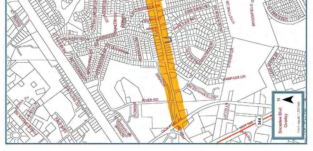
109
110 (E) Development and design requirements. Development of specific uses in the Socastee Boulevard Overlay Zone shall be consistent with the underlying zoning district. In addition to the requirements of the applicable underlying zoning district the following supplemental development regulations shall apply: (1) Building: a. 100 percent of the building facade that directly faces Socastee Boulevard shall be treated with brick, glass, siding (vinyl or wood), stone, or stucco (concrete masonry units shall not be used); b. 50 percent of the facade, facing any public right-of-way other than Socastee Boulevard shall be treated with one of the following: brick, glass, siding (vinyl or wood), stone, or stucco (unadorned concrete masonry units shall not be used); c. Blank or uninterrupted building facades visible from the corridor are discouraged. To create visual interest and attractive structures, design techniques should be employed to reduce building mass by breaking the facade into smaller segments using repetitive design features or similar architectural elements; d. Structure heights shall not exceed 36 feet, except copulas, spires, or other ornamental features are permitted to increase building heights to 50 feet; and e. Roof mounted mechanical equipment visible from the corridor shall be enclosed or screened to ensure that such features are not visible. Enclosures and screens shall be compatible to the architectural style of the proposed building. (2) Landscaping Acceptable plant species, maintenance standards, and sizes to meet the above requirements are listed in Section 527. a. Foundation Landscaping. Landscaping shall be provided around the foundation of any structure visible from any public right-of-way, according to the formula and standards enumerated below: 1. Calculation of required landscaping: PR = L/2.5 Where: PR = number of plants required L = building length or width (in feet) visible any public right-of-way 2. For each canopy or understory tree that is provided to meet the landscaping requirements the total number of required plants may be reduced by two. b. Perimeter landscaping. A 25-foot wide landscape buffer shall be provided between Socastee Boulevard and any renovated or newly constructed structure. Where non-similarly zoned properties abut each other, a four-foot high by ten-
111 foot wide planted berm, with side slopes no greater than 1:1, shall be installed. The buffer area and berm shall adhere to the following: 1. Planted with indigenous materials capable of survival in the environment in which they are installed with minimal maintenance; 2. Complement the structure, through color and foliage cover, for which they are planted around; 3. Include the following mixture of plant materials per 100 feet of corridor frontage: Six (6) - Canopy Trees Nine (9) - Understory Trees of which three shall be of a species that flowers or has leaves that change color seasonally Shrubs 20 - Evergreens or Conifers 4. When a natural undisturbed buffer is retained along Socastee Boulevard, the Zoning Administrator or designee may grant a modification to the side and rear buffers. Modification shall only be granted upon review and approval of a site plan showing the vegetation retained in the front buffer. In no instance, shall a waiver be granted if the plants retained in the buffer are not equal, in number, not plant type to those required above. When plants retained do not meet the required numbers above, the Zoning Administrator or designee may give credit for what is retained and require that the buffer along Socastee Boulevard only be supplemented by additional plant materials. Natural, undisturbed buffers meeting the following standards may qualify for the perimeter-landscaping waiver: 25-foot buffer is retained along Socastee Boulevard; A 20-foot buffer is retained along the sides and rear of the parcel; The plant materials retained consist of trees three (3) inches dbh (diameter at breast height) or greater along Socastee Boulevard and other vegetation along the sides and rear of the property be at least three (3) feet in height, or have stems greater than two(2) inches dbh. 5. Provide visual direction, through plant heights, to entrances or other access features to the site; and 6. Planted in a manner that will not impede traffic safety by blocking or otherwise obscuring traffic signals, signs or other devices. c. Tree preservation. The following standards shall apply to properties located within the corridor. 1. Protected or specimen trees, as identified in Section 527 of the zoning ordinance, shall not be removed from any property within the corridor unless the provisions of the Landscape, Buffer, and Tree Preservation standards (Section 527) of the zoning ordinance have been met; and
112 2. No fewer than an average of 15 protected specimen or eight (8) pine trees and, if necessary, other trees to obtain 160 dbh of trees per acre shall be retained on a site being prepared for new construction or renovation. If a site undergoing renovation cannot meet this requirement, all trees upon such site regardless of type and size shall be left undisturbed. Preserved trees may be removed upon approval of a sitelandscaping plan reviewed by the Zoning Administrator or their designee provided such plan meets the requirements of these regulations and those of the landscaping, buffer, and tree preservation requirements of Section 527 of the zoning ordinance. Protected or specimen trees used to meet this requirement shall consist of those identified in Section 527. d. Reductions in frontage landscaping. Landscaping requirements of the 25-foot frontage buffer may be reduced subject to the following: 1. The buffer width is increased to 40 feet. In such instance, the required plant materials shall be decreased by 30 percent; however, the number of pear tree species shall remain at three (3) per 100 feet of frontage on Socastee Boulevard; and 2. A three (3)-foot high by ten (10)-foot wide berm is constructed. In such instance, the required plant material may be reduced by 50 percent; however, the number of pear tree species shall remain at three (3) per 100 feet of corridor frontage. Areas not planted shall be covered with a groundcover, mulch, or grass suitable to stabilize the side slopes of the berm. Side slopes shall not exceed 1:1. (3) Auto, boat, mobile home and recreation-related sales and/or rental facilities. Businesses engaged in the sale and/or rental of autos, boats, mobile homes, or recreation-related vehicles that have frontage along Socastee Boulevard shall adhere the standards provided in subsection 4., above, and the following: a. Sales lots shall be screened by a three (3) foot high by ten (10) foot wide berm and planted with landscaping materials consistent with those indicated in subsection (2).b.3, above; b. Merchandise display pads shall be limited to 500 square feet for every 500 feet of frontage on Socastee Boulevard and may be placed within the required berm. Display pads shall be accessed from the rear of the berm to reduce conflicts with corridor traffic. c. Merchandise display pad area may be increased, to a maximum of 1,000 square feet for every 500 feet of corridor frontage, provided the required berm landscaping materials are increased by 25 percent. (4) Salvage yards, automobile repair facilities and mini-warehouses. Businesses engaged in salvage operations, repair of automobiles or storage of possessions in individually enclosed units/garages that have frontage along Socastee Boulevard shall adhere to the standards provided, above, and the following:
113 a. Storage areas for salvaged materials or vehicles waiting for repair shall be screened from the corridor by a six (6) foot high opaque enclosure which shall be located to the rear or side of the primary structure on the site; and b. A ten (10) foot landscaped buffer shall be provided around the base of the enclosure to soften its appearance. Landscaping utilized shall be consistent with that required in subsection (2).b.3, above. (5) Shipping/receiving areas and utility location. The following standards shall apply to Shipping/receiving and utility locations for businesses within the overlay zone: a. Facilities that utilize shipping docks for the receipt or shipping of merchandise shall have such facilities located in the rear of the structure or within a service courtyard shared by different business. Shared courtyards may be accessed from the front of the structure provided the entrance to such area is designed to blend into the architectural style of the structure and no dock facilities are visible from adjacent parking areas. b. Utility services shall be located underground when possible. If underground utility location is not possible, above grade utilities shall be located behind structures in a utility easement approved by the applicable utility authority. c. Utility substations visible from Socastee Boulevard shall be screened from view by a six (6) foot high opaque enclosure. A ten (10) foot landscaped buffer shall be planted around the base of the enclosure to further soften the appearance of the enclosed area. Landscaping utilized shall be consistent with that required in subsection (2).b.3, above. (6) Access Management When renovated or newly constructed structures have frontage along Socastee Boulevard and another paved public roadway, the primary access to the proposed structure shall be from the adjacent paved public roadway and not Socastee Boulevard. Access to the proposed structure from Socastee Boulevard shall be rightin/right-out only. (7) Parking. The following standards shall apply to parking areas for businesses within the overlay zone: a. Parking areas greater than ten (10) spaces shall set aside a minimum ten (10) percent of the interior parking area for landscaping. Planting areas shall be a minimum of 100 square feet and arranged to provide guidance for pedestrians toward building entrances. Planting areas shall include one (1) canopy tree no less than two and one-half (2 1/2) inches caliper at planting and any other plant materials complementing the design of the structure. Acceptable plant species, maintenance standards and sizes to meet the above requirements are listed in Table 1; and
114 b. Parking lot lighting shall be no greater than 20 feet in height and be shielded to ensure that no spillover occurs onto adjacent properties or rights-of-way. c. The use of rear parking lots and joint accesses are encouraged within the overlay zone. When properties are developed or redeveloped and incorporate rear parking lots and/or joint accesses, the following modification of the underlying zoning district standards shall apply: 1. When only joint access between parcels is provided the required parking for the individual use may be reduced by 25 percent. 2. When both rear parking lots and joint access between parcels are provided the following shall apply: (a) The modification allowed in subsection 12.(a); and (b) The minimum required lot area may be reduced by 25 percent; and (c) The side yard setbacks between adjacent structures may be reduced to zero provided applicable building requirements are met. Rear parking, in this case, is defined as a parking area where 75 percent or more of the required parking is located behind the rear building line. (8) On-site signage requirements. To reduce sign clutter resulting from intense development in the overlay zone the following standards shall apply to on-site signage: a. Freestanding signs shall be limited to 20 feet in height; b. Sign area shall be equal to one (1) square foot for every two (2) linear feet of frontage along Socastee Boulevard or a maximum of 200 square feet; c. Signs shall be designed to reflect the architectural character of the structure for which they are advertising and utilize a color scheme that complements the structure. Sign color should not create a visual distraction to the traveling public; d. Animated signs or signs with flashing lights are prohibited in the overlay zone, except time and temperature boards shall be allowed; e. External illumination shall be limited to 150 watts for each 40 square feet of sign area per sign side. Use of internally lit signage is strongly recommended. When used, sign illumination may be increased to 200 watts for each 40 square feet of sign area. f. For multi-tenant commercial developments, one (1) freestanding sign shall be permitted providing identification for the entire project. This sign may include the names of the individual businesses provided sign area does not exceed 200 square feet; g. One (1) wall sign per business shall be allowed in multi-tenant commercial developments. Sign area shall be equal to the width of the tenant space at a maximum of 100 square feet.
115 Temporary Vending Overlay Zones (A) Purpose. The Temporary Vending Overlay Zones are established to provide limits on the number of temporary vending permits that may be issued in conjunction with festivals, fairs, or special events occurring within the County. Issuance of temporary vending permits within the zones established below shall follow the standards established in this ordinance. (B) Applicability. The Temporary Vending Overlay Zones (TVOZ) are defined as: (1) Southern Strand Temporary Vending Overlay (SSTVO). The SSTVO is defined as the area bounded on the north by South Carolina Highway 544, on the east by the Atlantic Ocean, on the south by the Horry-Georgetown County Line, and the west by the Intracoastal Waterway. The SSTVO is shown in Attachment 1*. (2) Northern Strand Temporary Vending Overlay (NSTVO). The NSTVO is defined as the area lying east of western right-of-way line of US Highway 17 from the South Carolina-North Carolina state line to where such highway crosses the Intracoastal Waterway. The NSTVO is bounded by the Atlantic Ocean on the east, South Carolina Highway 544 on the south and the Intracoastal Waterway on the west. The NSTVO is shown in Attachment 2 *. (3) Western Strand Temporary Vending Overlay (WSTVO). The WSTVO is defined as the area of the Horry County not previously defined within either the SSTVO or NSTVO above. The WSTVO is shown in Attachment 3*. (C) Permitting Restrictions 1. Permits for temporary vending in the NSTVO and WSTVO as established above shall be limited to no more than 250 permits per festival, fair or special event. 2. Permits for temporary vending in the SSTVO) as established above shall be limited to no more than 150 permits for the Spring Bike Rally or other similar events and no more than 70 permits for the Fall Bike Rally or similar events.
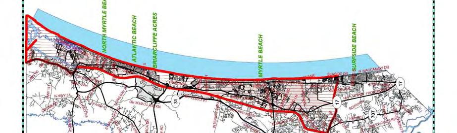
116
117
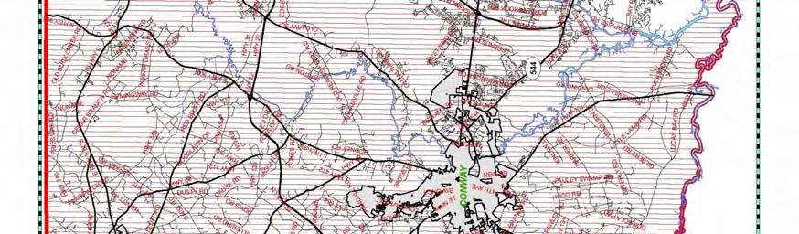
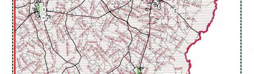
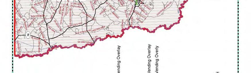
118
4.500 Preston Road Overlay District
 Section 4.500 Preston Road Overlay District 2004 Zoning Ordinance 4.500 Preston Road Overlay District (ZC 98-29; Ordinance No. 98-9-12) 4.501 Purpose To provide appropriate design standards for the use
Zoning Ordinance Section 1.100
 4.800 (ZC 98-45; Ordinance No. 98-9-13) 4.801 Purpose To provide appropriate design standards for the development of properties within the State Highway 121 corridor. These standards recognize the significance
ARTICLE 9: Landscaping
 ARTICLE 9: Landscaping 9-10 Legislative Intent The purpose of this Article is to regulate the planting and preservation of landscape materials; to facilitate the creation of an attractive and healthy environment;
Landscaping Standards
 CHAPTER 29 ARTICLE 403 29.403 Landscaping Standards Purpose: The purpose of this section is to protect and promote the public health, safety and general welfare by requiring landscaping in relation to
5.1.1 The streetscape along US Highway 64 (Brevard Road); and, The built environment within new residential developments; and,
; and, The built environment within new residential developments; and,") Article 5. Landscaping 5.1 Purpose The Town of Laurel Park s landscape standards are designed to create a beautiful, aesthetically pleasing built environment that will complement and enhance community
Article 5. Landscaping 5.1 Purpose The Town of Laurel Park s landscape standards are designed to create a beautiful, aesthetically pleasing built environment that will complement and enhance community
The purpose of the requirements in this Article is to provide for landscaping and screening of parking and other outdoor areas that will:
 XIII. LANDSCAPING & SCREENING A. Purpose The purpose of the requirements in this Article is to provide for landscaping and screening of parking and other outdoor areas that will: 1. Protect residential
CHAPTER 26 LANDSCAPING (Chapter added in its entirety 05-08)
") CHAPTER 26 LANDSCAPING (Chapter added in its entirety 05-08) 26.01 DESCRIPTION AND PURPOSE. Landscaping is an important element of the use, development and preservation of land, and a significant factor
CHAPTER 26 LANDSCAPING (Chapter added in its entirety 05-08) 26.01 DESCRIPTION AND PURPOSE. Landscaping is an important element of the use, development and preservation of land, and a significant factor
BUFFERS, TREE PROTECTION AND LANDSCAPING. Sec Purpose and Intent.
 ARTICLE 20 BUFFERS, TREE PROTECTION AND LANDSCAPING Sec. 20.1. Purpose and Intent. Trees improve air and water quality, reduce soil erosion, reduce noise and glare, provide habitat for desirable wildlife,
LANDSCAPE ORDINANCE PASADENA PLANNING DEPARTMENT (713) FAX (713)
 FAX (713)") LANDSCAPE ORDINANCE PASADENA PLANNING DEPARTMENT (713) 475-5543 FAX (713) 477-1072 ARTICLE X. LANDSCAPING OF NONRESIDENTIAL SITES* Sec. 9-195. Applicability. (a) This article shall apply to the following:
LANDSCAPE ORDINANCE PASADENA PLANNING DEPARTMENT (713) 475-5543 FAX (713) 477-1072 ARTICLE X. LANDSCAPING OF NONRESIDENTIAL SITES* Sec. 9-195. Applicability. (a) This article shall apply to the following:
CHESAPEAKE LANDSCAPE ORDINANCE
 CHESAPEAKE LANDSCAPE ORDINANCE CONSERVATION PRESERVATION CZO 19-600 Effective October 16, 2008 BUFFER YARD C PARKING LOT REFORESTATION YEAR 1 REFORESTATION YEAR 4 BUFFER YARD F CBPA REFORESTATION Page
CHAPTER 8 LANDSCAPE REGULATIONS
 CHAPTER 8 LANDSCAPE REGULATIONS Section 8.01 Intent. Landscaping is an essential element of the site design process, and is an important feature in promoting the public health, safety, comfort, general
Request Conditional Use Permit (Automobile Repair Garage) Staff Planner Kevin Kemp
 Staff Planner Kevin Kemp") Request Conditional Use Permit (Automobile Repair Garage) Staff Planner Kevin Kemp Location 845 Lynnhaven Parkway GPIN 14963473030000 Election District Rose Hall Site Size 0.40 acre portion of a 6.35 acre
Request Conditional Use Permit (Automobile Repair Garage) Staff Planner Kevin Kemp Location 845 Lynnhaven Parkway GPIN 14963473030000 Election District Rose Hall Site Size 0.40 acre portion of a 6.35 acre
DEVELOPMENT CONTROLS MEDICAL DISTRICT
 6.01. GENERAL DESIGN GUIDELINES A. Site Planning B. Architectural Design C. Medical Facility Signage & Lighting D. Exhibit 48. ARCHITECTURAL DESIGN CONCEPTS 6.02. MEDICAL FACILITY STANDARDS & GUIDELINES
g) "Minor repair" means repairs dealing primarily with nonstructural portions of the fence, as well as appearance.
 Minor repair means repairs dealing primarily with nonstructural portions of the fence, as well as appearance.") 6.2.4 FENCES, WALLS AND SCREENS: To protect the use and enjoyment of residential property by providing for the passage of air and light; to protect public welfare and safety by providing for the safe movement
6.2.4 FENCES, WALLS AND SCREENS: To protect the use and enjoyment of residential property by providing for the passage of air and light; to protect public welfare and safety by providing for the safe movement
Article 10: Landscaping and Buffering
 10.01: Purpose Article 10: Landscaping 10.01: Purpose The purpose of this article is to: A) Promote and protect the interest of the public convenience, comfort, prosperity, or general welfare in accordance
GENERAL LANDSCAPE PROVISIONS. The following landscape provisions shall be adhered to by all land uses unless otherwise noted:
 CHAPTER 1.18 Sections: 1.18.005 Purpose. 1.18.010 Landscaping, Buffering, and Fencing Improvements Required. 1.18.015 General Landscape Provisions. 1.18.020 Landscaping Plan. 1.18.025 Single-Family Dwellings
City of Aurora Planning Department DESIGN STANDARDS FOR MOTOR VEHICLE FUEL DISPENSING STATION. August 3, 1998
 City of Aurora Planning Department DESIGN STANDARDS FOR MOTOR VEHICLE FUEL DISPENSING STATION August 3, 1998 1. GENERAL PURPOSE AND APPLICABILITY The following design standards for motor vehicle fuel dispensing
Ephrata Municipal Code, Chapter 19.07, Landscaping Regulations DRAFT January 28, 2013 Page 1
 Chapter 19.07 LANDSCAPING REGULATIONS Sections: 19.07.010 Purpose. 19.07.020 Landscape plan approval. 19.07.030 Failure to complete required landscaping Inspection. 19.07.040 General landscape requirements
V-5 TREE PROTECTION AND LANDSCAPING REQUIREMENTS
 V-5 TREE PROTECTION AND LANDSCAPING REQUIREMENTS V-5.1 General A. Intent: It is the intent of this section to establish protective regulations for trees within the City of Milton, in order to better control
PART I-D BUFFERS AND LANDSCAPING REQUIREMENTS
 District Regulations Of General Applicability ARTICLE IX PART I-D BUFFERS AND LANDSCAPING REQUIREMENTS 9-107 BUFFERS AND LANDSCAPING 9-107 A. General Landscaping and Maintenance Requirements. Except for
(c) Certification of buffer plans. The MPC staff shall certify approved buffer plans to the zoning administrator for the issuance of permits.
 Certification of buffer plans. The MPC staff shall certify approved buffer plans to the zoning administrator for the issuance of permits.") Sec. 8-3066. Visual buffers and screening. (a) Generally. Buffers shall be provided as set forth herein to effectively protect all property from the adverse effects of adjacent land use activity of a more
Sec. 8-3066. Visual buffers and screening. (a) Generally. Buffers shall be provided as set forth herein to effectively protect all property from the adverse effects of adjacent land use activity of a more
Chapter 19.5 LANDSCAPING REQUIREMENTS
 Chapter 19.5 LANDSCAPING REQUIREMENTS Sec. 19.5-1. Intent The intent of the landscaping requirements stated herein are as follows: To aid in stabilizing the environment's ecological balance by contribution
DEPARTMENT OF PLANNING JEFFERSON PARISH, LOUISIANA
 DEPARTMENT OF PLANNING JEFFERSON PARISH, LOUISIANA DESIGN REVIEW REPORT : CPZ-3-1 : (S) Cynthia Lee-Sheng AT LARGE: A Chris Roberts B Elton M. Lagasse ADVERTISING DATES: 06/03/1 06/10/1 06/17/1 PAB PUBLIC
ARTICLE RRCO RED ROCK CORRIDOR OVERLAY DISTRICT
 ARTICLE 11.10 RRCO RED ROCK CORRIDOR OVERLAY DISTRICT (adopted 11/22/2011 MC16-116-11) SECTIONS: 11.10.01 Intent 11.10.02 Boundaries of District 11.10.03 Development Standards 11.10.04 Variance 11.10.01
ARTICLE 9: LANDSCAPING AND FENCING REQUIREMENTS
 ARTICLE 9: LANDSCAPING AND FENCING REQUIREMENTS Section 9.01 Intent The intent of the landscaping requirements are to improve the appearance of lot areas and soften paved areas and buildings; to provide
Improve the appearance of off-street parking areas, vehicular use areas, and property abutting public and private roads;
 Bedford Township, MI (Monroe Co.) 2012 http://library.municode.com/index.aspx?clientid=02123 400.1907 - Landscaping and screening. Se 1907. 1. Intent. Landscaping, greenbelts, and screening are necessary
CHAPTER ADDITIONAL REQUIREMENTS IN THE NC, NEIGHBORHOOD COMMERCIAL ZONE
 CITY OF MOSES LAKE MUNICIPAL CODE CHAPTER 18.31 ADDITIONAL REQUIREMENTS IN THE NC, NEIGHBORHOOD COMMERCIAL ZONE Sections: 18.31.010 Purpose 18.31.020 Minimum Lot Area 18.31.030 Setbacks 18.31.040 Maximum
Sec Development Standards in the Environmental Overlay (EO) District
 District") Sec. 4-12 Development Standards in the Environmental Overlay (EO) District a. Applicability. The Environmental Overlay District applies to areas identified on the official Zoning Map. Environmental Overlay
Sec. 4-12 Development Standards in the Environmental Overlay (EO) District a. Applicability. The Environmental Overlay District applies to areas identified on the official Zoning Map. Environmental Overlay
ARTICLE XII BUFFER REQUIREMENTS
 ARTICLE XII 1200. Intent. It is the intent of this section to establish standards to provide for buffer amenities and screening throughout unincorporated Georgetown County. The purpose of these standards
Sec Intent and purpose.
 1 of 5 10/12/2012 10:33 AM Hastings, Michigan, Code of Ordinances >> PART II - CODE OF ORDINANCES >> Chapter 90 - ZONING >> ARTICLE XII. - LANDSCAPING >> ARTICLE XII. - LANDSCAPING Sec. 90-1006. - Intent
Chapter PEDESTRIAN COMMERCIAL (PC) ZONING DISTRICT
 ZONING DISTRICT") Chapter 11-17 PEDESTRIAN COMMERCIAL (PC) ZONING DISTRICT Sections: 11-17-01 GENERAL PURPOSE 11-17-02 PERMITTED BUILDING TYPES 11-17-03 USES PERMITTED WITH DESIGN REVIEW 11-17-04 USES PERMITTED BY CONDITIONAL
Chapter 11-17 PEDESTRIAN COMMERCIAL (PC) ZONING DISTRICT Sections: 11-17-01 GENERAL PURPOSE 11-17-02 PERMITTED BUILDING TYPES 11-17-03 USES PERMITTED WITH DESIGN REVIEW 11-17-04 USES PERMITTED BY CONDITIONAL
SECTION RESIDENTIAL LANDSCAPING, STREETSCAPING, AND AMENITY STANDARDS
 SECTION 3.5400 RESIDENTIAL LANDSCAPING, STREETSCAPING, AND AMENITY STANDARDS 3.5401 RESIDENTIAL LANDSCAPE STANDARDS a) These standards shall apply to any single family detached and duplex residential zoning
CHAPTER SPECIAL PURPOSE AND OVERLAY ZONING DISTRICTS
 Special Purpose and Overlay Zoning Districts 106.28.010 CHAPTER 106.28 - SPECIAL PURPOSE AND OVERLAY ZONING DISTRICTS SPECIAL PURPOSE AND OVERLAY ZONING DISTRICTS Sections: 106.28.010 - Purpose 106.28.020
SECTION 1000 HIGHWAY CORRIDOR OVERLAY DISTRICT REGULATIONS
 SECTION 1000 HIGHWAY CORRIDOR OVERLAY DISTRICT REGULATIONS 1001.00 INTENT AND PURPOSE... 1000-1 1002.00 CLASSIFICATIONS... 1000-1 1003.00 DEVELOPMENT STANDARDS TABLES Page 1003.01 Buffer Requirements...................................
ARTICLE 3 LANDSCAPING AND SCREENING REQUIREMENTS
 ARTICLE 3 CHAPTER 4 LANDSCAPING AND SCREENING REQUIREMENTS SEC 3.401 SEC 3.402 (D) (E) PURPOSE: The purpose of this Chapter is to establish minimum standards for the design, installation, and maintenance
ORDINANCE Underline: Additions to Ordinance Strike-through: Deleted Text from Existing Ordinance
 AN ORDINANCE OF INDIAN RIVER COUNTY, FLORIDA CONCERNING AMENDMENTS TO LAND DEVELOPMENT REGULATIONS (LDRS); PROVIDING FINDINGS; PROVIDING FOR AMENDMENTS TO CHAPTER, 901, DEFINITIONS; CHAPTER 911, ZONING;
180 ZONING 180. ARTICLE XLII STREETSCAPE ENHANCEMENT OVERLAY ( SEO ) DISTRICT [Added Ord. No. 1086]
![180 ZONING 180. ARTICLE XLII STREETSCAPE ENHANCEMENT OVERLAY ( SEO ) DISTRICT [Added Ord. No. 1086]](/thumbs/75/72360049.jpg "180 ZONING 180. ARTICLE XLII STREETSCAPE ENHANCEMENT OVERLAY ( SEO ) DISTRICT [Added Ord. No. 1086]") 180 ZONING 180 ARTICLE XLII STREETSCAPE ENHANCEMENT OVERLAY ( SEO ) DISTRICT [Added 4-6-2016 Ord. No. 1086] 180.145. SEO DISTRICT 180.145.1. Intent. The SEO DISTRICT Regulations are intended to address
180 ZONING 180 ARTICLE XLII STREETSCAPE ENHANCEMENT OVERLAY ( SEO ) DISTRICT [Added 4-6-2016 Ord. No. 1086] 180.145. SEO DISTRICT 180.145.1. Intent. The SEO DISTRICT Regulations are intended to address
Bylaw A Bylaw to amend Bylaw 12800, as amended, The Edmonton Zoning Bylaw Amendment No. 2239
 Bylaw 17672 A Bylaw to amend Bylaw 12800, as amended, The Edmonton Zoning Bylaw Amendment No. 2239 WHEREAS City Council at its meeting of February 22, 2001, gave third reading to Bylaw 12800, as amended;
ARTICLE IX SPECIAL PERMIT USES
 ARTICLE IX SPECIAL PERMIT USES All special permit uses cited in Article IX and Attachment A of this Ordinance or any other Section of this Ordinance shall be subject to Site Plan Review. The procedures
ARTICLE 5 LANDSCAPE IMPROVEMENTS
 ARTICLE 5 LANDSCAPE IMPROVEMENTS 5-1 Purpose and Applicability 5-2 Landscape Plans and Installation 5-3 Landscaping Standards 5-4 Landscape Maintenance ARTICLE 5-1 PURPOSE AND APPLICABILITY 5-1-1 Purpose
Section 511: 11 th Street Overlay District 1. Intent: 11 th Street is the primary entrance route into the city from the south, providing direct
 Section 511: 11 th Street Overlay District 1. Intent: 11 th Street is the primary entrance route into the city from the south, providing direct access from US Highway 12. As such, the community has identified
Request Change in Nonconformity. Staff Recommendation Approval. Staff Planner Jonathan Sanders
 Applicant & Owner Public Hearing April 11, 2018 City Council Election District Beach Agenda Item 5 Request Change in Nonconformity Staff Recommendation Approval Staff Planner Jonathan Sanders Location
ARTICLE XIX SCREENING, LANDSCAPING AND TREES
 ARTICLE XIX SCREENING, LANDSCAPING AND TREES Part I. Landscaping and Screening Section 304 Purpose. The purpose of this Part is to establish minimum landscaping and screening requirements that provide
5.1 Commercial and Industrial Development. (Effective April 1, 2006)
") 5.1 Commercial and Industrial Development. (Effective April 1, 2006) A. Applicability: The requirements of this section (5.10) shall apply to all uses within the LB Local Business; HB Highway Business;
5.1 Commercial and Industrial Development. (Effective April 1, 2006) A. Applicability: The requirements of this section (5.10) shall apply to all uses within the LB Local Business; HB Highway Business;
The Highway Overlay District applies to an area within the City of Papillion's zoning jurisdiction described as:
 ARTICLE XXVIII. HOD Highway Overlay District 205-164. Intent. The Highway Overlay District recognizes the strategic importance of the Highway 370 corridor as an entrance to Papillion from Interstate 80
Parks & Recreation Tree Board - Tree Ordinance Angola, Indiana
 Parks & Recreation Tree Board - Tree Ordinance Angola, Indiana 97.01 PURPOSE. (A) Promote and enhance the beauty of the city through tree preservation and landscaping. (B) Safeguard the ecological environment
Sec Landscaping standards. (a) Purpose and applicability. (1) Purpose. Recognizing that trees and landscaping contribute to the public
 Purpose and applicability. (1) Purpose. Recognizing that trees and landscaping contribute to the public") Sec. 26-176. Landscaping standards. (a) Purpose and applicability. (1) Purpose. Recognizing that trees and landscaping contribute to the public health, safety, and welfare, Richland County has set standards
Sec. 26-176. Landscaping standards. (a) Purpose and applicability. (1) Purpose. Recognizing that trees and landscaping contribute to the public health, safety, and welfare, Richland County has set standards
CHAPTER 530 SITE PLAN REVIEW
 ARTICLE I. GENERAL PROVISIONS CHAPTER 530 SITE PLAN REVIEW Community Planning and Economic Development Development Services Division 250 South 4 th Street, Room 300 Minneapolis MN 55415-1316 612-673-3000
ZONING ORDINANCE FOR THE ZONED UNINCORPORATED AREAS ARTICLE 1300 OF PUTNAM COUNTY, WEST VIRGINIA Page 119 ARTICLE 1300 LANDSCAPING AND SCREENING
 OF PUTNAM COUNTY, WEST VIRGINIA Page 119 ARTICLE 1300 LSCAPING SCREENING 1300.01 STATEMENT OF LEGISLATIVE INTENT 1300.02 GENERAL PROVISIONS 1300.03 REQUIREMENTS 1300.04 SUBMISSION APPROVAL 1300.05 SCREENING
ARTICLE 12. LANDSCAPING REQUIREMENTS.
 ARTICLE 12. LANDSCAPING REQUIREMENTS. 12.1 GENERAL REQUIREMENTS 12.2 LANDSCAPE PLAN REQUIRED 12.3 LANDSCAPE DESIGN STANDARDS 12.4 REQUIRED PARKING LOT LANDSCAPE 12.5 REQUIRED BUFFER YARD 12.6 ADDITIONAL
The Town Board of the Town of Vienna, County of Dane, State of Wisconsin, does ordain and adopt as follows.
 ORDINANCE DRIVEWAYS AND CULVERTS NO. 6-5-06 ORDINANCE CONCERNING DRIVEWAY AND CULVERT REQUIREMENTS 1-1-1 Driveway Permits; Culvert Requirements 1-1-2 Driveway and Culvert Location, Design and Construction
D. Landscape Design. 1. Coverage Intent: To provide adequate landscaping materials that enhance the appearance of development projects.
 D. Landscape Design The standards and guidelines in this section give design guidance for the landscaping components of industrial and office projects. City regulations require that all landscaping be
Request Conditional Use Permit (Automobile Service Station) Staff Recommendation Approval. Staff Planner Bill Landfair
 Staff Recommendation Approval. Staff Planner Bill Landfair") Applicant Property Owner RTR Real Estate Associates, Tidewater Investments, LLC, Bruce Ranomski Public Hearing December 12, 2018 City Council Election District Centerville Agenda Item 7 Request Conditional
Applicant Property Owner RTR Real Estate Associates, Tidewater Investments, LLC, Bruce Ranomski Public Hearing December 12, 2018 City Council Election District Centerville Agenda Item 7 Request Conditional
ARTICLE 21A LANDSCAPING AND SCREENING
 ARTICLE 21A LANDSCAPING AND SCREENING SECTION 21A.01 INTENT AND SCOPE OF REQUIREMENTS Landscaping, greenbelts, and screening are necessary for the continued protection and enhancement of all land uses.
BOULEVARD AND PARKWAY STANDARDS
 88-323 BOULEVARD AND PARKWAY STANDARDS 88-323-01 PURPOSE Considerable public and private investment exists and is expected to occur adjacent to boulevards and parkways within the city. The following standards
Design Guidelines for Residential Subdivisions
 Design Guidelines for Residential Subdivisions Development Services 972-466-3225 cityofcarrollton.com This page intentionally left blank. Table of Contents Purpose... 1 Design Objectives... 1 Design Guidelines
ARTICLE VI. LANDSCAPING, BUFFERING, AND OPEN SPACE REQUIREMENTS.
 ARTICLE VI. LANDSCAPING, BUFFERING, AND OPEN SPACE REQUIREMENTS. 6-1. Landscaping Standards. (A) Landscaping. In order to maintain and enhance the existing tree coverage in Norwood, to promote careful
Narcoossee Roadway Corridor
 Community Meeting Narcoossee Roadway Corridor April 5, 2012 Meeting Agenda Purpose of Meeting Continuation of Study Update Process (Previous Meetings Oct. & Nov., 2011) Tonight s Objective Review Proposals
MIDTOWN MIXED-USE VILLAGE. TECHNICAL DATA SHEET COMPONENT C-1 FOR PUBLIC HEARING - PETITION NUMBER Project No RZ1.1. Issued.
 N MIDTOWN MIXED-USE VILLAGE TECHNICAL DATA SHEET COMPONENT C- FOR PUBLIC HEARING - PETITION NUMBER 04-00 Project No. 496 Issued Revised SCALE: " = 0' N 0 0 0 40 RZ. c GENERAL PROVISIONS: a. SITE LOCATION.
The Brown Road Innovation Zoning District shall be specified for the areas as designated on the Charter Township of Orion Zoning Map.
 Section 34.00 Preamble The purpose of the Brown Road Innovation Zoning District shall be to encourage the development of property in accordance with the Charter Township of Orion Master Plan in a manner
Chapter Landscaping and Screening
 Chapter 17-11 Landscaping and Screening 17-11-0050 Guide to the Chicago Landscape Ordinance...11-1 17-11-0100 Parkway Trees...11-1 17-11-0200 Vehicular Use Areas...11-2 17-11-0300 Trash Storage Area Screening...11-9
CASE NUMBER: 16SN0701 APPLICANT: Hanky, LLC
 STAFF S ANALYSIS AND RECOMMENDATION Planning Commission (CPC) Public Hearing Date: MAY 17, 2016 CPC Time Remaining: 100 DAYS Applicant s Agent: DANIEL L. CASKIE (804-569-7060) Applicant s Contact: MICHAEL
CITY OF ZEELAND PLANNING COMMISSION
 APPLICATION FOR SITE PLAN REVIEW AND SPECIAL LAND USE Date City Official App. Filing Fee Rec'd ($350) NOTE TO APPLICANT: Please submit this application for Site Plan Review along with twenty (20) copies
Landscaping Regulations for City of Billings & Yellowstone County Jurisdictional Area
 Landscaping Regulations for City of Billings & Yellowstone County Jurisdictional Area Sec. 27-1101. Purpose. The purpose of this section is to provide landscaping and performance standards which: A. Enhance
Rootstown Township Zoning Resolution 8/26/99. CHAPTER 430 Landscaping And Screening Requirements
 430.01 Purpose. 430.02 Landscaping along the street frontage. 430.03 Screening and landscaping of parking lots 430.04 Screening and buffering when lot abuts a residential district. 430.05 Screening of
Design Review Application *Please call prior to submittal meeting to determine applicable fees*
 CITY OF EAGLE 660 E. Civic Lane, Eagle, ID 83616 Phone#: (208) 939-0227 Fax: (208) 938-3854 Design Review Application *Please call prior to submittal meeting to determine applicable fees* FILE NO.: CROSS
U.S. Highway 377 North Overlay District. 1. General Purpose and Description
 U.S. Highway 377 North Overlay District 1. General Purpose and Description The purpose of the U.S. Highway 377 North Overlay District is to implement the recommendations within the U.S. Highway 377 North
AWH REPORT OF THE PLANNING AND DEVELOPMENT DEPARTMENT FOR APPLICATION FOR REZONING ORDINANCE TO PLANNED UNIT DEVELOPMENT
 AWH REPORT OF THE PLANNING AND DEVELOPMENT DEPARTMENT FOR APPLICATION FOR REZONING ORDINANCE TO PLANNED UNIT DEVELOPMENT MAY 8, 2014 The Planning and Development Department hereby forwards to the Planning
Appendix D North Road/N. Leroy Street Subarea Plan
 North Road/N. Leroy Street Subarea Plan INTRODUCTION The City of Fenton Master Plan was updated in 1996 and included a subarea plan for the North Leroy Street area of the City. It was recognized at that
Table 34-1 (amended )
") Section 34.00 Preamble The purpose of the Brown Road Innovation Zoning District shall be to encourage the development of property in accordance with the Charter Township of Orion Master Plan in a manner
Section 34.00 Preamble The purpose of the Brown Road Innovation Zoning District shall be to encourage the development of property in accordance with the Charter Township of Orion Master Plan in a manner
M E M O R A N D U M. Consider a recommendation of a site plan for Sherwin Williams, a proposed approximately 4,500 square-foot paint store.
 M E M O R A N D U M Meeting Date: February 10, 2014 Item No. E- 8 To: From: Subject: Planning and Zoning Commission Cassie Harashe, Planner I Consider a recommendation of a Site Plan for Sherwin Williams,
VILLAGE OF CHANNAHON COMMERCIAL DESIGN GUIDELINES. Village of Channahon S. Navajo Drive Channahon, IL (815)
") VILLAGE OF CHANNAHON COMMERCIAL DESIGN GUIDELINES Village of Channahon 24555 S. Navajo Drive Channahon, IL 60410 (815) 467-6644 www.channahon.org Adopted March 6, 2006 VILLAGE OF CHANNAHON COMMERCIAL DESIGN
VILLAGE OF CHANNAHON COMMERCIAL DESIGN GUIDELINES Village of Channahon 24555 S. Navajo Drive Channahon, IL 60410 (815) 467-6644 www.channahon.org Adopted March 6, 2006 VILLAGE OF CHANNAHON COMMERCIAL DESIGN
ARTICLE XIII USE PROVISIONS. Section Mall of Georgia Overlay District Requirements:
 ARTICLE XIII USE PROVISIONS Section 1315. Mall of Georgia Overlay District Requirements: Section 1315.1 Findings and Purposes: The Mall of Georgia Overlay District is intended to enhance the viability
Chapter RM MULTI FAMILY BUILDING ZONES
 Chapter 19.17 RM MULTI FAMILY BUILDING ZONES 19.17.010 Established 19.17.020 Primary Permitted Uses 19.17.030 Accessory Permitted Uses 19.17.040 Secondary Permitted Uses 19.17.050 Conditional Property
A. Reducing noise pollution, air pollution, and visual pollution;
 A well designed landscape, when made an integral part of a development plan, provides aesthetic appeal and makes an important contribution to the health, safety, and general welfare of the community by:
6 November 13, 2013 Public Hearing APPLICANT: CAH HOLDINGS, LLC
 6 November 13, 2013 Public Hearing APPLICANT:, LLC PROPERTY OWNER: LC REALTY, LLC STAFF PLANNER: Kevin Kemp REQUEST: Conditional Use Permit (Automated Car Wash) ADDRESS / DESCRIPTION: 3565 Holland Road
Request Modification of Conditions (Automobile Service Station) Staff Recommendation Approval. Staff Planner Jimmy McNamara
 Staff Recommendation Approval. Staff Planner Jimmy McNamara") Applicant Larae Tucker Property Owner Doswell Ventures, LLC Public Hearing May 10, 2017 City Council Election District Princess Anne Agenda Item 3 Request Modification of Conditions (Automobile Service
Applicant Larae Tucker Property Owner Doswell Ventures, LLC Public Hearing May 10, 2017 City Council Election District Princess Anne Agenda Item 3 Request Modification of Conditions (Automobile Service
City of Bonner Springs, Kansas
 City of Bonner Springs, Kansas Site Plan Requirements, Outdoor Lighting Standards & Landscape Regulations March 29, 2017 City of Bonner Springs Planning Division SECTION 10. SITE PLANS: ZONING ORDINANCE
Chapter 1123: Landscaping and Buffering
 Chapter 1123: Landscaping and Buffering 1123.01 Purpose The preservation of existing trees and vegetation, as well as the planting of new trees and vegetation, can significantly add to the quality of the
ARTICLE II. LANDSCAPING
 ARTICLE II. LANDSCAPING Sec. 35-31. Landscaping required for all site development. (a) Residential Developments: (1) All residential lots shall provide a minimum of one (1) boulevard tree (planted between
Landscape area requirement compliance and landscape plans
 ARTICLE 6 LANDSCAPING 6-1. Statement of Intent The purpose of this Article is to promote the public health, safety and welfare by providing for the preservation, installation and maintenance of trees and
Location and Field Inspection: History: Master Plan Recommendation:
 R E S O L U T I O N WHEREAS, the Prince George s County Planning Board has reviewed Special Permit Application No. SP-130008, Sudsville Laundry, requesting a special permit to construct an addition and
Landscape and fencing requirements of this Chapter shall apply to all new landscaped areas.
 Chapter 19.06. Landscaping and Fencing. Sections: 19.06.01. Purpose. 19.06.02. Required Landscaping Improvements. 19.06.03. General Provisions. 19.06.04. Landscaping Plan. 19.06.05. Completion of Landscape
Required Internal Landscaping Percentage of Ground Cover in Living Materials Percentage of Tree Size
 CHAPTER 12-24 LANDSCAPE STANDARDS 12-24-101 Purpose 12-24-102 Landscaping Required 12-24-103 Parking Lot Screening 12-24-104 Parking Lot Trees 12-24-105 12-24-106 Landscaped Setbacks Buffers 12-24-107
TOWN OF CARY. PARCEL INFORMATION Parcel # Realid # Area acres
 TOWN OF CARY Lochmere PUD Amendment -Greensview Tract 00-REZ-31 FINAL CONDITIONS APPLICANT(S) OWNER(S) OWNER(S) Preston Creative School, LLC c/o Mr. Jim Fauver 110 Preston Grande Way Morrisville, NC 27560
Application for Site Plan Review
 Application for Site Plan Review City of Pontiac Office of Land Use and Strategic Planning 47450 Woodward Ave, Pontiac, MI 48342 T: 248.758.2800 F: 248.758.2827 Property/Project Address: Sidwell Number:
Development Services Staff Report for Design Review Committee
 Development Services Staff Report for Design Review Committee To: Design Review Committee From: DS Staff: Erika Akin Subject: Proposed Addition to J s Car Wash File: DSRFY2016-1 Date: January 19, 2016
DEPARTMENT OF PLANNING JEFFERSON PARISH, LOUISIANA
 DEPARTMENT OF PLANNING JEFFERSON PARISH, LOUISIANA DESIGN REVIEW REPORT DOCKET NO: : : : Paul D. Johnston AT LARGE: A: Christopher L. Roberts B: Cynthia Lee-Sheng ADVERTISING DATES: PAB PUBLIC HEARING:
C-I-10. The effect of establishing a comprehensive site review as follows will: B. Reduce the cluttered aspects of current development by:
 C-I-10 PART C SECTION I ARTICLE 10 GENERAL REGULATIONS PROJECT SITE REVIEW I. Purpose The effect of establishing a comprehensive site review as follows will: A. Protect streetscapes from projects that
SITE PLAN REVIEW APPLICATION AND CHECKLIST
 SITE PLAN REVIEW APPLICATION AND CHECKLIST PROJECT SUMMARY: Project Name: City/ETA Location: City ETA (Application fee & number of copies needed are based on location) Property Location (Legal Description
AIRPORT BUSINESS PARK
 PIER MAC PETROLEUM INSTALLATION LTD. AIRPORT BUSINESS PARK DEVELOPMENT APPLICATIONS March 2003 4.1 Airport Business Park Development Permit Area 4.1.1 Justification/Design Concept The design concept envisioned
2 January 13, 2010 Public Hearing APPLICANT: AUTOBELL CAR WASH, INC
 REQUEST: Conditional Use Permit (car wash) 2 January 13, 2010 Public Hearing APPLICANT: AUTOBELL CAR WASH, INC PROPERTY OWNER: MESSER 1060 INDEPENDENCE BOULEVARD STAFF PLANNER: Carolyn A.K. Smith ADDRESS
These landscaping standards are organized into nine main sub-sections. They include:
 Section 23-6-3(B): Purpose and Intent g. Exterior Lighting 3. LANDSCAPING 368 Exterior lighting for loading areas shall comply with the standards in Section 23-6-8, Exterior Lighting. (A) SECTION ORGANIZATION
ORDINANCE NO /2008
 ORDINANCE NO. 2008-3-18 2007/2008 AN ORDINANCE AMENDING CHAPTER 7.01 (ZONING CODE) OF THE TOWN OF SHEBOYGAN MUNICIPAL CODE TO CREATE ARCHITECTURAL, EXTERIOR LIGHTING, AND LANDSCAPING STANDARDS WHEREAS,
Architectural and Appearance Design Manual. Town of Lexington, SC 1
 Town of Lexington, SC 1 Introduction Purpose In order to preserve and enhance the rural, cultural, economic and historic character of the Town of Lexington, by providing detailed review of the design,
CHAPTER 11 HC HIGHWAY COMMERCIAL DISTRICT
 CHAPTER 11 HC HIGHWAY COMMERCIAL DISTRICT SECTION 11.01 DESCRIPTION AND PURPOSE This District is intended primarily for uses emphasizing highway related service, such as service stations, restaurants,
Landscaping, buffering and screening shall be provided to:
 ARTICLE 14 Landscaping, Buffering and Screening 14.01 PURPOSE Landscaping, buffering and screening shall be provided to: A. Encourage the creation of an attractive appearance, provide interest and lessen
R E S O L U T I O N. Single-Family Residence/ Church. 2,488 sq. ft. 2,488 sq. ft. Area Parking Required: Church
 R E S O L U T I O N WHEREAS, the Prince George s County Planning Board is charged with the approval of Detailed Site Plans pursuant to Part 3, Division 9 of the Zoning Ordinance of the Prince George s
This article shall be known and may be referred to as the "Landscaping Ordinance of the City of Baytown" or simply as the "Landscaping Ordinance.
 ARTICLE XIV. LANDSCAPING* *Note: See the editor's note to ch. 18. Sec. 18-1201. General regulations. (a) Title. This article shall be known and may be referred to as the "Landscaping Ordinance of the City
CHAPTER 3. Design Standards for Business, Commercial, Industrial, Recreational and Institutional Uses
 CHAPTER 3 Design Standards for Business, Commercial, Section Number Title Ordinance Number Date of Ordinance 16-3-1 Applicability 2006-11 2008-04 07-01-08 16-3-2 Uniform Standards for Architectural Design