770 Don Mills Road and 805 Don Mills Road - Official Plan Amendment and Zoning By-law Amendment Application Preliminary Report
|
|
|
- Amos Jefferson
- 5 years ago
- Views:
Transcription

1 REPORT FOR ACTION 770 Don Mills Road and 805 Don Mills Road - Official Plan Amendment and Zoning By-law Amendment Application Preliminary Report Date: To: From: Wards: June 22, 2018 North York Community Council Director, Community Planning, North York District Ward 26- Don Valley West Planning Application Number: NNY 26 OZ SUMMARY This report provides preliminary information and an early opportunity to raise issues for follow-up with regard to the application. It seeks Community Council's direction on the community consultation process and indicates the expected timing for a Final Report to City Council. The application has been circulated to all appropriate agencies and City divisions for comment and a staff review of the application is underway. This application consists of two development sites, located at the southeast and southwest corners of Don Mills Road and Eglinton Avenue East, which are both proposed to be developed with mixed-use buildings. Each CreateTO development site would consist of a total of three residential towers above a total of two six-storey base buildings, with heights ranging from 22 to 52-storeys. The overall development proposes a total of 156,502 square metres of gross floor area across the two sites including: 150,684 square metres of residential gross floor area and 5,818 square metres of non-residential gross floor area, of which 2,315 square metres of gross floor area is proposed for community uses. A total of 2,377 residential units are proposed across the two sites. The development proposal also seeks to introduce two new public streets, as well as redesigning the north end of Ferrand Drive to align with Gervais Drive on the north side of Eglinton Avenue East in an effort to regularize the intersection and improve functionality. One on-site park is proposed for each site totalling 4,540 square metres along with a combined 5,185 square metres of Privately-Owned Publicly Accessible Space (POPS) across both sites. The applicant requested pre-application consultation meetings with City staff to present development concepts, receive feedback from staff on development concepts and on emerging principles and objectives of the Don Mills Crossing Study and assist in defining the requirements for complete application submission. Page 1 of 50
2 The City staff review of the Official Plan and Zoning By-law Amendment application is currently underway. The application has been circulated to all appropriate agencies and City divisions for comment. A Community Consultation Meeting is anticipated to be held in the fourth quarter of A Final Report will be submitted for Council's consideration following community consultation, the resolution of outstanding issues related to this application, and the holding of a statutory Public Meeting under the Planning Act. The Final Report is anticipated to be before Council in the second quarter of City Planning staff have identified the preliminary issues to be resolved with the proposal as described in this Report. These issues and all additional matters that arise through the development review process will need to be addressed prior to submission of the Final Report to Council. RECOMMENDATIONS The City Planning Division recommends that: 1. Staff be directed to schedule a community consultation meeting for the lands at 770 Don Mills Road and 805 Don Mills Road together with the Ward Councillor. 2. Notice for the community consultation meeting be given to landowners and residents within 120 metres of the site. 3. Notice for the statutory public meeting under the Planning Act be given according to the regulations of the Planning Act. FINANCIAL IMPACT The recommendations in this report have no financial impact. DECISION HISTORY Eglinton Crosstown LRT and Eglinton Connects Planning Study The Eglinton Crosstown LRT is currently under construction along the Eglinton Avenue corridor between Weston Road and the Kennedy TTC station and will have both underground and at-grade sections. The Eglinton LRT is generally located above ground through this section of Eglinton Avenue East, however, as the LRT approaches the intersection of Eglinton Avenue East and Don Mills Road, it travels below grade for approximately 490 metres. Both the LRT and the Science Centre Station will be underground at the intersection of Don Mills Road and Eglinton Avenue East. The main station entrance is to be located on the southwest corner and a secondary entrance is to be located at the northeast corner along with a bus terminal. City staff undertook the Eglinton Connects Planning Study of the Eglinton LRT corridor which developed a vision for Eglinton Avenue to guide future development. City Council Page 2 of 50
3 considered the Final Directions Report for the Eglinton Connects Planning Study in May 2014 and identified six Focus Areas at stations along the corridor that could accommodate additional population and employment growth for further study and master planning. The intersection of Don Mills Road and Eglinton Avenue East was identified as one of the six Focus Areas. Three City-owned properties abutting the intersection of Don Mills Road and Eglinton Avenue East are located within the Focus Area at the northeast corner, and the two subject properties at the southeast and southwest corners. The Celestica property at the northwest corner of the intersection was not included in the Focus Area other than the frontage of the site along Eglinton Avenue which was identified as a 'greenway' in the Eglinton Connects study. However, as part of the Don Mills Crossing Study, the entirety of the Celestica lands have been included within the study area. The Final Directions Report and Council's decision on the Eglinton Connects Study can be found here: The Phase 1 (Part 1 and Part 2) Implementation Report and Council decision on the Eglinton Connects Study can be found here: A Proposals Report for the Don Mills Crossing Study with a draft Secondary Plan was recommended for approval with amendments at Planning and Growth Management Committee (PGMC) on June 7, It is scheduled to be heard at City Council on June 26, The report recommends that the draft Secondary Plan be used as a basis for staff to undertake additional stakeholder and public consultation. In addition, it is recommended that the draft Secondary Plan be used to review development applications in the draft Secondary Plan Area. PGMC also requested that City Planning meet with Ontario Science Centre officials to discuss the future plans for their lands and City Planning meet with senior School Board staff to discuss their future plans for schools within the Study Area. The Secondary Plan and Final Report on the Don Mills Crossing Study will be considered by Planning and Growth Management Committee in the first quarter of The Don Mills Crossing Proposals Report and PGMC's recommendations can be found here: ISSUE BACKGROUND Application Description This application consists of two development sites, with one located at the southeast corner and the other at the southwest corner of Don Mills Road and Eglinton Avenue East, that are both proposed to be developed with mixed-use buildings (see Attachment 2). Each development site would consist of a total of 3 residential towers above a total of two six-storey base buildings, with heights ranging from 22 to 52-storeys. The overall development proposes a total of 156,502 square metres of gross floor area across the two sites including: 150,684 square metres of residential gross floor area and 5,818 Page 3 of 50
4 square metres of non-residential gross floor area, of which 2,315 square metres of gross floor area is proposed for community uses. A total of 2,377 residential units are proposed across the two sites. 770 Don Mills Road (southwest corner) The site at 770 Don Mills Road (the southwest corner of Don Mills Road and Eglinton Avenue East) is proposed to be developed with two buildings with one at the northern end of the site and the other at the southern end of the site. These buildings would be divided by an east-west linear Privately-Owned Publically Accessible Space (POPS). The site would be comprised of a total of 3 residential towers above two six-storey mixed-use base buildings (see Attachment 5A: Site Plan). Building A is proposed to be located along the Eglinton Avenue East frontage, to the west of the new stand-alone Eglinton Crosstown Light Rail Transit (LRT) Science Centre Station. The building would be comprised of a 43-storey (130.5 metre) easterly tower and a 52-storey (157.9 metre) westerly tower connected by a 6-storey mixed-use base building. The tower portions of the buildings are proposed to have maximum floor plates of 750 square metres and a separation distance of 32 metres. Building A is proposed to provide active uses at grade along both Eglinton Avenue East and the proposed linear POPS to activate the public realm. At the ground and second levels, community space is proposed along the Eglinton Avenue East frontage, and commercial space is proposed within the northeast corner of the building fronting onto both Don Mills Road and Eglinton Avenue East. Townhouse-style units are proposed to front the linear POPS (see Attachment 6A: Ground Floor Plan). Building B is proposed to be located south of Building A with a height of 28-storeys (85.5 metres) above a base building of 6 storeys. The tower floor plate is proposed to be a maximum of 750 square metres and the tower separation distance from the 43- storey east tower of Building A to the 28-storey tower of Building B is 28 metres. The ground and second floors of Building B are proposed to contain commercial space along the Don Mills Road frontage. Townhouse-style units are proposed on the first and second floors, fronting Public Street A and along the linear POPs between Building A and Building B (see Attachment 6A: Ground Floor Plan). The linear POPS with an area of approximately 4,795 square metres, is proposed to run in an east-west direction mid-way through the site from Don Mills Road to proposed Public Street A. The POPS is proposed to provide pedestrian access to Building A and B residential lobbies, retail space, and townhouse units. A 3,270 square metre public park is proposed at the western edge of the site, west of proposed Public Street A, and adjacent to the Don Valley ravine system. Residential lobbies are proposed along the west end and southeast end of Building A and the central part of Building B. Proposed Public Street A is a new street that is to serve both the proposed Wynford Green community at the northwest corner of the Don Mills Road and Eglinton Avenue East intersection and the subject site at 770 Don Mills Road. For the subject site, proposed Public Street A would travel south from Eglinton Avenue East beginning with a right-of-way (ROW) width of 21.6 metres and along the western boundary of the site, and then along the southern boundary of the site and connecting to Don Mills Road with Page 4 of 50
5 a ROW width of 18.6 metres. Vehicular access to the site is proposed from a driveway from the south end of Building B off of Public Street A. The driveway would also provide access to an internalized drop-off/pick-up area, secondary lobby entrance, and delivery area within the first parking level. Parking would be within a shared three level underground garage. Access to loading would be from a separate vehicular entrance west of the main vehicular access driveway. A total of 92,106 square metres of gross floor area is proposed for the site at 770 Don Mills Road, of which, 89,191 square metres is proposed to be residential gross floor area, with the remaining 2,915 square metres proposed to be non-residential gross floor area. A total of 1,407 dwelling units are proposed with 698 below grade parking spaces and 1,431 bicycle parking spaces. An overall density of 4.15 times the lot area is proposed for this site. 805 Don Mills Road (southeast corner) The site at 805 Don Mills Road (the southeast corner of Don Mills Road and Eglinton Avenue East) is proposed to be developed with two buildings at the western and eastern ends of the site. The buildings will be divided by a public park and a linear POPS. The two buildings would be comprised of three residential towers above two sixstorey mixed-use podium buildings (see Attachment 5B: Site Plan). Building C is proposed to be located at the corner along the Eglinton Avenue East frontage and will also have frontage onto Don Mills Road and proposed Public Street C. Building C is proposed to consist of a 28-storey western tower (85.5 metres) and 34- storey eastern tower (103.5 metres) connected by a 3- to 6-storey podium with retail space along Eglinton Avenue East. The applicant proposes retail uses at grade and the second floor, and townhouse style units along proposed Public Street C (see Attachment 6B: Ground Floor Plan). The podium is proposed to have a height of 6- storeys along Eglinton Avenue East. The tower elements are proposed with a maximum floor plate of 750 square metres and a separation distance of 29 metres. Building D is proposed to be located on the east portion of the site with frontage along Eglinton Avenue East, Ferrand Drive and proposed Public Street C. The building is proposed to be 22-storeys in height (67.5 metres) with a 6-storey podium. The tower floor plate is proposed to be a maximum of 750 square metres and separated from the east tower of Building C by 42 metres. Community space is proposed at grade along Eglinton Avenue East and within the second storey on the north side of the building (see Attachment 6B: Ground Floor Plan). A public park with an area of 1,270 square metres is proposed in the middle of this development site, between Buildings C and D. An adjoining POPS is proposed to the north of the park parallel to Eglinton Avenue East. Proposed underneath the POPS area is parking and a drive aisle connecting the underground parking garages of Buildings C and D. The area of the POPS is proposed to be approximately 390 square metres. Residential lobbies are proposed at the east and west ends of Building C and the west end of Building D. Page 5 of 50
6 Public Street C is proposed with a ROW width of 16.5 metres in an east-west direction connecting Don Mills Road to Ferrand Drive along the southern boundary of the development site. Vehicular access to each building would be from their own individual driveways off of proposed Public Street C. Buildings C and D would share a consolidated three level underground parking garage. Loading and servicing for these buildings would be internal to the site from the driveway access points at the south end of the site. A total of 64,396 square metres of gross floor area is proposed for the lands at 805 Don Mills Road, of which, 61,493 square metres is proposed to be residential gross floor area with the remaining 2,903 square metres proposed as non-residential gross floor area. A total of 970 dwelling units are proposed at this site, with 540 below grade parking spaces and 981 bicycle parking spaces. A total density of 4.48 times the lot area is proposed for this site. Additional project statistics can be found in Attachments 1A and 1B: Application Data Sheet. Building Elevations can be found in Attachments 7 and 8, and Building Renderings can be found in Attachment 9. Site and Surrounding Area The proposal is comprised of two properties located at the southwest (770 Don Mills Road) and southeast (805 Don Mills Road) corners of Don Mills Road and Eglinton Avenue East. The development area of the two properties combined is approximately 9 acres (3.6 hectares). 770 Don Mills Road The development parcel located at 770 Don Mills Road has a site area of approximately 2.22 hectares (5.49 acres), and is irregular in shape with a portion of the site extending westward towards the Don Valley. The site has a frontage of approximately 275 metres along Eglinton Avenue East and 119 metres along Don Mills Road. The lands at 770 Don Mills Road are also the location of the new main entrance to the Science Centre Station on the Eglinton Crosstown LRT line, which is currently under construction. The site is currently occupied by a surface parking lot and a small open space area. The subject development site is the northern 2.22 hectare (5.49 acre) portion of 770 Don Mills Road. The southern 5.8 hectare (14.35 acre) portion of 770 Don Mills Road includes the Ontario Science Centre and associated parking lot areas. The entire property municipally known as 770 Don Mills Road includes a frontage of approximately 615 metres along Don Mills Road from Eglinton Avenue East to north of Gateway Boulevard. In August 2010, City Council authorized the transfer of the northern portion of the lands to Build Toronto (now CreateTO). Land uses and development in the vicinity of the lands at 770 Don Mills Road are as follows: North: Existing to the north of the subject site is a hectare (60.35 acre) property that contains two large industrial/office buildings (Celestica) with a current gross floor Page 6 of 50
7 area of approximately 113,000 square metres (1,216,000 square feet). The Celestica site is the subject of a development proposal (Wynford Green) for a new master planned, mixed-use, and transit supportive community, for which a settlement was recommended for approval by PGMC on June 7 th, 2018 and will be considered by City Council on June 26 th, The portion of the Wynford Green community immediately north of the subject site includes a 9-storey office building and three residential towers with heights of 39, 40 and 48-storeys. East: To the east of the site is Don Mills Road and further east is the other parcel subject to this application at 805 Don Mills Road. Additionally, there is an existing 18- storey residential building, 24-storey office building (Foresters) and residential towers of 28 and 30 storeys under construction at 1185 Eglinton Avenue East. South: Immediately south of the subject site is a surface parking lot and the Ontario Science Centre. West: To the west of the site are the Don Valley Ravine and Trail, and E.T. Seaton Park. 805 Don Mills Road The lands at 805 Don Mills Road have an area of approximately 1.43 hectares (3.55 acres) and are irregular in shape. The site has approximately 235 metres of frontage along Eglinton Avenue East and approximately 75 metres of frontage along Don Mills Road. The site is currently used as a surface parking lot by the Ontario Science Centre. In May 2010, City Council authorized the transfer of the lands to Build Toronto (now CreateTO). Land uses and development in the vicinity of the lands at 805 Don Mills Road are as follows: North: To the north of the site is the future location of a Toronto Transit Commission bus terminal and secondary access to the future Eglinton LRT station. East: To the east of the subject site is a low density neighbourhood comprised of twostorey semi-detached dwellings and townhomes. South: Immediately south of the subject site is a place of worship, a site with residential towers of 28 and 30 storeys under construction at 1185 Eglinton Avenue East, and an existing 18-storey condo building. Further south is the Flemingdon Park community comprised of low-rise, mid-rise and high-rise residential buildings. West: To the west of the site is the adjacent development site at 770 Don Mills Road. Section 2 of the Planning Act The Planning Act governs land use planning in Ontario and sets out the means by which a municipality must implement land use planning decisions. In particular, section 2 of the Planning Act requires that municipalities, when carrying out their responsibility under this Act, shall have regard for matters of provincial interest including: Page 7 of 50
8 (a) the protection of ecological systems, including natural areas, features and functions; (f) the adequate provision and efficient use of communication, transportation, sewage and water services and waste management systems; (h) the orderly development of safe and healthy communities; (i) the adequate provision and distribution of educational, health, social, cultural and recreational facilities; (j) the adequate provision of a full range of housing, including affordable housing; (k) the adequate provision of employment opportunities; (o) the protection of public health and safety; (p) the appropriate location of growth and development; (q) the promotion of development that is designed to be sustainable, to support public transit and to be oriented to pedestrians; (r) the promotion of built form that is well-designed, encourages a sense of place, and provides for public spaces that are of high quality, safe, accessible, attractive and vibrant; and (s) the mitigation of greenhouse gas emissions and adaptation to a changing climate. These matters, which all approval authorities shall have regard for in carrying out their responsibilities under the Planning Act, are particularly relevant to this proposal. The Ontario Planning Act (Planning Act, R.S.O. 1990, c. P.13) can be found at: Provincial Policy Statement The Provincial Policy Statement (2014) ("PPS") provides policy direction on land use planning and development to promote strong communities, a strong economy, and a clean and healthy environment. It includes policies on key issues that affect communities, such as: The efficient and wise use and management of land and infrastructure over the long term in order to minimize impacts on air, water and other resources; Protection of the natural and built environment; Building strong, sustainable and resilient communities that enhance health and social well-being by ensuring opportunities exist locally for employment; Residential development promoting a mix of housing; recreation, parks and open space; transportation choices that increase the use of active transportation and transit; and Encouraging a sense of place in communities, by promoting well-designed built form and by conserving features that help define local character. The PPS recognizes that local context and character is important. Policies are outcomeoriented, and some policies provide flexibility in their implementation provided that provincial interests are upheld. City Council s planning decisions are required, by the Planning Act, to be consistent with the PPS. The PPS identifies Official Plans as the most important vehicle for implementing the PPS, and states that comprehensive, integrated and long-term planning is best achieved through Official Plans. Page 8 of 50
9 The PPS provides direction for managing and directing land use to achieve efficient and resilient development and land patterns in Section 1.1. Policies within this section promote an appropriate range and mix of residential, employment, institutional, recreation, park and open space and other uses to meet long term needs. Section of the PPS provides provincial policy direction regarding settlement areas. The PPS recognizes that Ontario s settlement areas vary significantly in terms of size, and that development pressures and land use change will vary across Ontario. It recognizes that the vitality of settlement areas is critical to the long-term economic prosperity of communities. To facilitate this, the PPS states that planning authorities shall identify appropriate locations and promote opportunities for intensification where this can be accommodated, considering existing building stock, availability of existing and planned infrastructure, and public service facilities required to accommodate projected needs. Appropriate development standards should be promoted which facilitate intensification, redevelopment and compact form, while avoiding or mitigating risk to public health and safety. Housing policies are contained in Section 1.4 of the PPS, with the objective of providing an appropriate range and mix of housing types and densities required to meet the projected requirements of current and future residents. In particular: planning authorities are to direct the development of new housing towards locations where appropriate infrastructure and public service facilities are or will be available; promote densities for new housing which efficiently use land, resources, infrastructure and public service facilities, and support the use of active transportation and transit in areas where it exists or is to be development; and establish development standards for residential intensification, redevelopment and new residential development which minimize the cost of housing and facilitate compact form, while maintaining appropriate levels of public health and safety. Section 1.5 of the PPS promotes healthy, active communities by: planning public streets, spaces and facilities to be safe, meet the needs of pedestrians, foster social interaction and facilitate active transportation and community connectivity; and planning and providing for a full range and equitable distribution of publicly-accessible built and natural settings for recreation, including facilities, parkland, public spaces, open space areas, trails and linkages. Section of the PPS speaks to making efficient use of existing and planned infrastructure, including through the use of transportation demand management strategies. As part of a multimodal transportation system, connectivity within and among transportation systems and modes should be maintained and where possible improved. A land use pattern, density and mix of uses should be promoted that minimize the length and number of vehicle trips and support current and future use of transit and active transportation. PPS Policy related to the wise use and management of resources speak to natural features and areas being protected for the long term. Policy speaks to the diversity and connectivity of natural features in an area, and the long-term ecological function and biodiversity of natural heritage systems, should be maintained, restored or, where possible, improved, recognizing linkages between and among the natural heritage Page 9 of 50
10 features and areas. Furthermore, the PPS also states that development or site alteration shall not be permitted on adjacent lands to natural heritage features and areas unless the ecological function of the adjacent lands will not be negatively impacted. In order to protect public health and safety and prevent property damage, development and site alteration shall generally be directed to areas outside of flooding hazards, erosion hazards and other hazardous lands and sites. The City of Toronto uses the PPS to guide its official plan and to inform decisions on other planning and development matters. The PPS is issued under Section 3 of the Planning Act and all decisions of Council affecting land use planning matters "shall be consistent with" the Provincial Policy Statement. The Provincial Policy Statement (2014) is available at: In the submission forms for development approval, the applicant has indicated that the application is consistent with the PPS. Staff will be evaluating the Zoning By-law amendment application against the PPS (2014) noted above as part of the City's development approval process. Growth Plan for the Greater Golden Horseshoe, 2017 The Growth Plan for the Greater Golden Horseshoe (2017) ("Growth Plan") provides a strategic framework for managing growth in the Greater Golden Horseshoe (GGH) region including: Setting minimum density targets within settlement areas and related policies directing municipalities to make more efficient use of land, resources and infrastructure to reduce sprawl, cultivate a culture of conservation and promote compact built form and better-designed communities with high quality built form and an attractive and vibrant public realm established through site design and urban design standards; Directing municipalities to engage in an integrated approach to infrastructure planning and investment optimization as part of the land use planning process; Building complete communities with a diverse range of housing options, public service facilities, recreation and green space that better connect transit to where people live and work; Retaining viable employment lands and encouraging municipalities to develop employment strategies to attract and retain jobs; Minimizing the negative impacts of climate change by undertaking stormwater management planning that assesses the impacts of extreme weather events and incorporates green infrastructure; and Recognizing the importance of watershed planning for the protection of the quality and quantity of water and hydrologic features and areas. The vision and objectives of the Growth Plan contained in Section 1.2 support the development of the GGH as a place with exceptional quality of life, offering a variety of choices for living, and supported by modern and resilient infrastructure and an Page 10 of 50
11 integrated transportation network. To realize this vision, the Growth Plan's guiding principles focus on achieving complete communities, the efficient use of land and infrastructure, and the integration of land use planning with planning for investments in public infrastructure and services. While the Growth Plan prioritizes intensification to optimize land, infrastructure, and public transit, it also provides for different approaches to managing growth that recognize the diversity of communities within the Greater Golden Horseshoe. The Growth Plan states that policies represent minimum standards, and decision-makers are encouraged to go beyond minimum standards, unless doing so would conflict with other policies within the PPS or any other provincial plan. Chapter 2 of the Growth Plan articulates policies on where and how growth should occur. This growth is directed to key areas and prioritizes intensification, with a focus on strategic growth areas, including urban growth centres and major transit station areas, as well as brownfield sites and greyfields. The Growth Plan also emphasizes the importance of planning for complete communities, which support quality of life and human health by encouraging the use of active transportation, providing high-quality public spaces, adequate parkland, and opportunities for recreation. Furthermore, they provide a balance of jobs and housing, reduce the need for long-distance commuting, and support transit ridership and active transportation, and minimize land consumption through compact built form. Thus, the Growth Plan underscores its purpose as not simply to accommodate growth, but to achieve greater societal, economic and environmental benefits for communities in the GGH. The connection between infrastructure and growth is discussed in Chapter 3 of the Growth Plan. The Growth Plan requires municipalities to undertake an integrated approach to infrastructure planning, land use planning, infrastructure investment, transit planning, and public service facilities planning and investment. Section of the Growth Plan articulates polices relating to infrastructure corridors, and maintains that existing and planned corridors are protected to meet current and projected needs in accordance with the transportation and infrastructure corridor protection policies in the PPS. Like other provincial plans, the Growth Plan for the Greater Golden Horseshoe (2017) builds upon the policy foundation provided by the Provincial Policy Statement (2014) and provides more specific land use planning policies to address issues facing the GGH region. The policies of the Growth Plan take precedence over the policies of the PPS to the extent of any conflict, except where the relevant legislation provides otherwise. All decisions by Council affecting land use planning matters are required by the Planning Act, to conform, or not conflict, as the case may be, with the Growth Plan. The Growth Plan is available at: In the submission forms for development approval, the applicant has indicated that the application is consistent with the Growth Plan. Staff will be evaluating this Zoning Bylaw amendment application against the Growth Plan (2017) noted above as part of the City's development approval process. Page 11 of 50
12 Toronto Official Plan Section 4 - Land Use Designations The City of Toronto Official Plan is a long-term vision for how the City should grow and is the most important vehicle for implementing the PPS and Growth Plan. The subject land at 805 Don Mills Road is designated as Mixed Use Areas and the subject land at 770 Don Mills Road is designated both as Institutional Areas and Parks and Open Space Areas - Natural Areas along its western edge, on Map 20 of the Official Plan (see Attachment 3: Official Plan Land Use Map). Section 4.3 indicates that Parks and Open Space Areas are the parks and open spaces, valleys, watercourses and ravines, portions of the waterfront, golf courses and cemeteries that comprise a green open space network. They are comprised of Natural Areas, Parks and Other Open Space Areas. Development is generally prohibited within Parks and Open Space Areas except for recreational and cultural facilities, conservation projects, cemetery facilities, public transit and essential public works and utilities where supported by appropriate assessment. Natural Areas will be maintained primarily in a natural state. Section 4.5 indicates that Mixed Use Areas are made up of a broad range of commercial, residential, and institutional uses, in single use or mixed use buildings, as well as parks and open spaces and utilities. Policy 2 provides development criteria for Mixed Use Areas to ensure, among other matters that development will: Create a balance of high quality commercial, residential, institutional and open spaces uses that reduces automobile dependency and meets the needs of the local community; Provide for new jobs and homes for Toronto's growing population on underutilized lands, creating and sustaining well-paid, stable, safe and fulfilling employment opportunities; Locate and mass new buildings to provide a transition between areas of different development intensity and scale, as necessary to achieve the objectives of the Plan, through means such as providing appropriate setbacks and/or stepping down of heights, particularly towards lower scale Neighbourhoods; Locate and mass new buildings so as to adequately limit shadow impacts on adjacent Neighbourhoods, particularly during the spring and fall equinoxes; Locate and mass new buildings to frame the edges of streets and parks with good proportion and maintain sunlight and comfortable wind conditions for pedestrians on adjacent streets, parks and open spaces; Provide an attractive, comfortable and safe pedestrian environment; Have access to schools, parks, community centres, libraries and childcare; Take advantage of nearby transit service; Provide good site access and circulation and an adequate supply of parking for residents and visitors; Locate and screen service areas, ramps and garbage storage to minimize the impact on adjacent streets and residences; and Provide indoor and outdoor recreation space for building residents in every significant multi-unit residential development. Page 12 of 50
13 Section 4.8 indicates that Institutional Areas are made up of major educational, health and government uses with their ancillary uses, cultural, parks and recreational, religious, commercial and institutional residence facilities, including the full range of housing associated with a health institution, as well as utility uses. Major health and educational institutions are important employers and service providers and will continue to grow to serve the needs of an increasing city and regional population. Section Healthy Neighbourhoods The subject site at 805 Don Mills Road is located in a Mixed Use Areas designation. Policy requires that developments in Mixed Use Areas that are adjacent or close to Neighbourhoods will: be compatible with those Neighbourhoods; provide a gradual transition of scale and density, as necessary to achieve the objectives of the Plan through the stepping down of buildings towards and setbacks from those Neighbourhoods; maintain adequate light and privacy for residents in those Neighbourhoods; and attenuate resulting traffic and parking impacts on adjacent neighbourhood streets so as not to significantly diminish the residential amenity of those Neighbourhoods. Policy indicates that intensification of land adjacent to neighbourhoods will be carefully controlled so that neighbourhoods are protected from negative impact. Where significant intensification of land adjacent to a Neighbourhood or Apartment Neighbourhood is proposed, Council will determine, at the earliest point in the process whether or not a Secondary Plan, area specific zoning by-law or area specific policy will be created in consultation with the local community. Section The Green Space System The subject site at 770 Don Mills Road is located adjacent to a Green Space System on the Urban Structure Map 2 of the Official Plan. The Green Space System is comprised of lands within the Parks and Open Space Areas land use designations which are large, have significant natural heritage or recreational value and which are connected. They should be protected, improved and added to whenever feasible. Policy requires that actions be taken to improve, preserve and enhance the Green Space System by: a) improving public access and enjoyment of lands under public ownership; b) maintaining and increasing public access to privately owned lands, where appropriate; c) restoring, creating and protecting a variety of landscapes; and d) establishing co-operative partnerships in the stewardship of lands and water. Policy further states that public agencies and Torontonians will be encouraged to support the protection, enhancement and restoration of links within and between elements of the Green Space System. Policy further states that the Green Space System will be expanded by linking additional parks and open spaces by: acquiring such linkages where feasible; and acquiring lands, or easements over lands, associated with private development which can be connected to the Green Space System for the extension of recreational trails or which have important natural heritage value. Page 13 of 50
14 Transportation The integration of transportation and land use is critical to achieving the overall aim of increasing accessibility throughout the City. The policies of the Plan reflect the importance of mutually supportive transportation and land use policies that combine mechanisms of mobility and proximity to maximize accessibility. Transportation Section of the Official Plan speaks to the City's transportation network being maintained and developed to support the growth management objectives of the Plan by protecting and developing the network right-of-ways as shown on Map 3 of the Official Plan. At this location, both Eglinton Avenue East and Don Mills Road are major streets as identified on Map 3 of the Official Plan with the Eglinton Avenue East right-of-way width identified as 45 metres and over and the Don Mills Road right-of-way identified as 33 metres. Policies also require that: streets are not closed to public use and stay within the public realm where they provide present and future access for vehicles, pedestrians and bicycles, space for utilities and services, building address, view corridors and sight lines. These are policies to ensure that new streets will be provided in consideration of surrounding land uses and will contribute to the development of a connected network which provides direct and clearly understood travel routes for all transportation modes and users throughout the City and acts as a fundamental organizing element of the City's physical structure. Also, both Eglinton Avenue East and Don Mills Road are identified on Map 4 of the Official Plan as transit corridors and on Map 5 of the Official Plan as transit priority segments. Policy j) speaks to implementing transit services in exclusive rights-ofway in the corridors identified on Map 4 as priorities are established, funding becomes available and the Environmental Assessment review processes are completed. Also, policy l) speaks to increased transit priority throughout the City by giving buses and streetcars priority at signalized intersections and by introducing other priority measures on selected bus and streetcar routes, including those identified on Map 5, such as: reserved or dedicated lanes for buses and streetcars; and limiting or removing on-street parking during part or all of the day. The Eglinton Avenue corridor has been planned to accommodate the Eglinton Crosstown LRT which is to extend from Weston Road to the Kennedy TTC Subway Station and is currently under construction. The Don Mills Road corridor from Steeles Avenue to Eastern Avenue is being considered for rapid transit expansion as a longer term project that Metrolinx identified in their regional transit plan. A joint study between the Toronto Transit Commission, Metrolinx and the City is underway to advance the planning and environmental assessment for the Relief Line North. Details can be found here: The subject sites are located within a mobility hub area within The Big Move, Metrolinx's regional transportation plan. Mobility hubs are places of connectivity between regional and rapid transit services, where different modes of transportation come together seamlessly. They have or are planned to have, an attractive, intensive concentration of employment, living, shopping and enjoyment around a major transit station. There are two types of mobility hubs identified in The Big Move with this location identified as a Gateway Hub. Gateway Hubs are major transit station areas that are located at the Page 14 of 50
15 interchange of two or more current or planned regional rapid transit lines with anticipated high levels of ridership. Don Mills Road and Eglinton Avenue East is identified as a gateway hub in the Greater Toronto & Hamilton Area (GTHA) and is currently served by local TTC bus services. This hub is planned to integrate Regional Rail, Rapid Transit and local bus services. The Metrolinx Mobility Hub Guidelines provide guidance for the design of development projects. The guidelines generally require that developments provide matters such as: seamless integration of transportation modes at the rapid transit station; safe and efficient movement of people with high levels of pedestrian priority; a vibrant, mixed-use environment with higher land use intensity; and an attractive public realm. Transportation Policies within Section 2.4 of the Official Plan encourage active forms of transportation by integrating and giving full consideration to pedestrian and cycling infrastructure in the design of all streets, neighbourhoods, major destinations, transit facilities and mobility hubs throughout the City. Transportation studies will identify the demands and impacts of new development, and identify transportation improvements, a Travel Demand Management (TDM) strategy and/or other mitigating measures to accommodate travel generated by the development. The City will show leadership within the region in the implementation of TDM measures to reduce auto dependence and rush-hour congestion in the road and transit networks through matters such as: actively pursuing measures which will increase the proportion of trips made by walking, cycling, and transit; increasing the average automobile occupancy rate; reducing the demand for vehicular travel; and supporting the workplace TDM efforts of Smart Commute Toronto and the region-wide Metrolinx Smart Commute program, as well as TDM programs supported by School Boards. Policy indicates that for sites in areas well serviced by transit, such as locations around rapid transit stations and along major transit routes, consideration will be given to the establishment of: minimum density requirements and maximum density limits, minimum and maximum parking requirements, redevelopment of surface commuter parking lots on City owned land, and rates for on-street parking and in City-owned parking facilities structured to discourage long-term commuter parking and to achieve a higher turnover by short-term users. In support of the TDM and environmental policies of the Plan, Policy indicates that the City may: support the conversion of required parking spaces to designated publicly accessible car-share spaces; encourage new developments to include publicly accessible bike share facilities; encourage parking providers to designate preferred parking spaces for exclusive use of carpool and low-emission vehicles; encourage parking providers to install plug in stations for electric vehicles; and provide on-street, reserved parking spaces for car share vehicles in selected locations. Additionally, policies, programs and infrastructure will be introduced to create a safe, comfortable and bicycle friendly environment that encourages people of all ages to cycle for everyday transportation; and an urban environment and infrastructure will be created that encourages and supports pedestrian movement throughout the City, for all ages and abilities. Page 15 of 50
16 The "Complete Streets" policies of the Official Plan contain overall objectives to: create a well-functioning street network that is planned and designed to provide safe access and efficient operation for all street activities and functions; provide safe and comfortable pedestrian, cycling and transit facilities; and balance the competing demands placed upon the use of street rights-of-way, including as settings for community and civic life. These objectives are to be applied when streets are constructed, reconstructed or otherwise improved. Section The Public Realm The Plan recognizes the importance of good design in the creation of a great city. The policies contained in this section emphasize the need for new development to improve the public realm (streets, sidewalks and open spaces) for pedestrians. The public realm policies speak to matters such as: City streets being significant public open spaces which connect people and places and support the development of sustainable, economically vibrant and complete communities; sidewalks and boulevards being designed to provide safe, attractive, interesting and comfortable spaces for pedestrians; design measures which promote pedestrian safety and security applied to streetscapes, parks, other public and private open spaces, and all new and renovated buildings; the design of new streets and that they should be public; the design of new city blocks and development lots to: promote street-oriented development with buildings fronting onto street and park edges, and provide adequate room for parking and servicing needs; and design and locate new parks and open spaces to connect and extend, wherever possible, to existing parks, natural areas, and other open spaces. Section Built Form The Official Plan built form policies in Section require that new development will: be located and organized to fit with its existing and/or planned context; frame and support adjacent streets, parks and open spaces to improve the safety, pedestrian interest and casual views to these spaces. locate and organize vehicle parking, vehicular access, service areas and utilities to minimize their impact on the property and on surrounding properties and to improve the safety and attractiveness of adjacent streets, parks and open spaces; be massed and exterior facades will be designed to fit harmoniously into its existing and/or planned context, and will limit its impact on neighbouring streets, parks and open spaces; be massed to define the edges of streets, parks and open spaces at good proportion with taller buildings located to ensure adequate access to sky view for the proposed and future uses of these areas; provide amenity for adjacent streets and open spaces to make these areas attractive, interesting, comfortable and functional for pedestrians; and provide indoor and outdoor amenity space for residents of every significant new multi-unit residential development. Page 16 of 50
17 Due to the larger civic responsibility and obligations associated with tall buildings, the built form policies of Section provide additional direction on how they fit into the existing and planned context and how they are designed. Policy 2 requires that tall building proposals address key urban design considerations that include: demonstrating how the proposal will contribute to and reinforce the overall City structure; taking into account the relationship of the site to topography and other tall buildings; and providing high quality, comfortable and usable publicly accessible open space areas. Section Housing The Plan provides direction on housing. Strong communities are the foundation of a healthy city and the Plan recognizes that opportunities for adequate and affordable housing are essential to supporting quality of life, economic competitiveness and social cohesion. Policy 1 encourages the provision of a full range of housing in terms of form, tenure, and affordability to meet the current and future needs of residents. Section 3.3 Building New Neighbourhoods New neighbourhoods usually need new infrastructure, streets, parks and local services to support new development and connect it with the surrounding fabric of the City. They must also function as communities, not just housing. New neighbourhoods will have a comprehensive planning framework reflecting the Plan's city-wide goals as well as the local context. New neighbourhoods should have: a community focal point, a fine grain of interconnected streets and pedestrian routes, a mix of uses and a range of building types, and high quality parks. They will also be integrated into the surrounding fabric of the City by: having good access to transit and good connections to surrounding streets and open spaces; uses and building scales that are compatible with surrounding development; community services and parks that fit within the wider system; and a housing mix that contributes to a full range of housing. Section The Natural Environment The City's significant natural heritage features and function are shown on Map 9 of the Official Plan. The natural heritage system is made up of areas where protecting, restoring and enhancing the natural features and function should have high priority in our city-building decisions. The Plan has policies in this section for the protection of natural heritage features. The western edge of the property at 770 Don Mills Road falls within and abuts the natural heritage system. In particular, policy requires that development be set back by at least 10 metres or more if warranted by the severity of existing or potential natural hazards from: the topof-bank of valleys, ravines and bluffs; and other locations where slope instability, erosions, flooding, or other physical conditions present a significant risk to life or property. Policy also states that land below the top-of-bank, or other hazard lands, may not be used to calculate permissible density in the zoning by-law or used to satisfy parkland dedication requirements. Policy indicates that development is generally not permitted in the natural heritage system. Where the underlying land use designation provides for development in or near the natural heritage system, development will: recognize natural heritage values and potential impacts on the natural ecosystem as much as is reasonable in the context of other objectives for the area; and minimize adverse impacts and when possible, restore and enhance the natural heritage Page 17 of 50
18 system. Policy indicates that all proposed development in or near the natural heritage system will be evaluated to assess the development's impacts on the natural heritage system and identify measures to mitigate negative impacts on and/or improve the natural heritage system. Section 37 Section 37 of the Planning Act enables the City to pass a zoning by-law to grant a height and/or a density increase for a proposal that is greater than the zoning by-law would otherwise permit in return for community benefits. Section 37 may be used for development with more than 10,000 square metres of gross floor area where the zoning by-law amendment increases the permitted density by at least 1,500 square metres and/or significantly increases the permitted height. All other relevant Official Plan policies will be considered in the evaluation of this development proposal. This application will be reviewed against the official plan policies described above as well as the policies of the Toronto Official Plan as a whole. The Toronto Official Plan can be found here: Don Mills Crossing Study Launched in June 2016, the Don Mills Crossing Study is one of the outcomes of City Council's May 2014 adoption of Eglinton Connects and its June 2016 settlement of an Ontario Municipal Board appeal for the Celestica lands. Both Council decisions require the development of a comprehensive planning framework concurrent with new development occurring in the area. Don Mills Crossing is a three phase study. In January 2017, Planning and Growth Management Committee adopted the Profile Report completed at the conclusion of Phase 1. In November 2017, Committee adopted the Don Mills Crossing Public Realm Plan Report which marked the conclusion of Phase 2 and was the framework upon which the draft Secondary Plan was prepared. Phase 3 focussed on policy development and further community engagement. This phase also involved continued coordination with staff in various City divisions and outside agencies to advance both the draft Secondary Plan and the review of development applications submitted for lands within the boundaries of the Study Area. The draft Don Mills Crossing Secondary Plan is a comprehensive planning framework that capitalizes on the significant public investment in new transit infrastructure by directing development to appropriate locations and securing the public realm amenities and facilities necessary to meet the existing and future needs of residents and workers. It advances a vision of a distinct and complete community that celebrates the natural heritage of the Don River Valley system and builds on the area's tradition of cultural and technological innovation. A full range of mobility options are provided for, with an emphasis on transit, travel demand management and the integration of pedestrian and cycling infrastructure into the public realm. New connections will provide opportunities to Page 18 of 50
19 make it more convenient to access jobs, services and daily activities in the community and beyond. While providing for intensification within the boundaries of the draft Secondary Plan Area, a key theme of the draft policies is improved connectivity with enhanced public realm treatments beyond the boundary to ensure that future growth does not occur in isolation and is integrated with the surrounding area. By connecting the natural, cultural, institutional and employment destinations found in the broader area around the Secondary Plan Area to the community at Don Mills and Eglinton, the existing residents and workers can experience the benefit generated by public investment in new transit infrastructure. A Proposals Report for the Don Mills Crossing Study with a draft Secondary Plan was considered and recommended for approval with amendments by Planning and Growth Management Committee on June 7, It is scheduled to be heard at City Council on June 26, The report recommends that the draft Secondary Plan be used as a basis for staff to undertake additional stakeholder and public consultation. In addition, it is recommended that the draft Secondary Plan be used to review development applications in the draft Secondary Plan Area. Following consultation through the summer and fall of 2018, staff proposes to bring forward the recommended Secondary Plan to a statutory meeting at Planning and Growth Management Committee in the first quarter of The website for Don Mills Crossing can be found here: initiatives/don-mills-crossing/ Planning and Growth Management Committee's decision on the Proposals Report can be found here: City-Wide Tall Building Design Guidelines In May 2013, Toronto City Council adopted the updated City-wide Tall Building Design Guidelines and directed City Planning staff to use these Guidelines in the evaluation of all new and current tall building development applications. The guidelines establish a unified set of performance measures for the evaluation of tall building proposals to ensure that they fit within their context and minimize their local impacts. The city-wide Guidelines are available at: Growing Up: Planning for Children in New Vertical Communities Guidelines The City-wide Growing Up: Planning for Children in New Vertical Communities draft guidelines were adopted by City Council in July The objectives of the guidelines are rooted in the Official Plan vision to create an attractive, safe and healthy city where children are valued and residents have access to housing, support services and recreational activities. The draft guidelines implement Official Plan policies that highlight the importance of integrated community facilities and amenities, the need for a comfortable and safe public realm and the creation of a range of housing options in Page 19 of 50
20 communities. The Guidelines and Council's decision can be found here: Zoning By-laws The in-force Zoning By-law applying to the lands at 770 Don Mills Road is Zoning Bylaw No. 7625, as amended, of the former City of North York. The lands are zoned Semi- Public Open Space Zone (O3) (see Attachment 4A: Zoning By-law 7625). The O3 zone permits public uses, including any station, yard, building, park or parkway, operated or used by the City of North York (now City of Toronto), the Province of Ontario, and a variety of other governmental bodies, agencies, and utilities. The O3 zone requires that no building be located closer to any lot line than a distance equal to the height of the structure. The new City-wide Zoning By-law No , as amended, does not apply to the majority of the lands at 770 Don Mills Road. The western-most portion of the site is zoned Open Space Natural (ON) Zone (see Attachment 4B: Zoning By-law ). This zone provides for the conservation of lands such as ravines and waterways that are part of the natural system. The lands at 805 Don Mills Road are currently unzoned as part of Zoning By-law No. 7625, as amended, of the former City of North York, as they form part of the Eglinton Avenue East right-of-way. The new City-wide Zoning By-law No , as amended, does not apply to the lands at 805 Don Mills Road. Additional Applications The development proposal for the subject sites is subject to Site Plan Control. Site Plan Control applications have not been submitted to date. The proposal will also require approval of a Plan of Subdivision, which will be submitted at a later date, in order to create the development blocks, public roads and parkland conveyances. COMMENTS Reasons for the Application The proposal requires an amendment to the Official Plan in order to redesignate the subject lands at 770 Don Mills Road from Institutional Areas to Mixed Use Areas in order to permit the mixed-use development on that site. The proposal also requires amendments to both the former City of North York Zoning By-law 7625, as amended, as well as to City of Toronto Zoning By-law , as amended. The zoning amendments are required for both of the subject properties in order to permit the proposed mix of uses as well as the various components of this new development which are not provided for by the current zoning. The zoning by-law amendment would establish appropriate development standards such as, but not limited to: building heights, density, setbacks, landscaping, vehicle and bike parking requirements. Page 20 of 50
21 Complete Application Submission The following reports/studies have been submitted with the application: Sun and Shadow Study, Planning and Urban Design Rationale, including Community Services and Facilities Report, Public Consultation Strategy, Toronto Green Standards Checklist, Stage 1 Archaeological Assessment, Arborist Report, Tree Inventory and Preservation Plan, Pedestrian Level Wind Assessment, Preliminary Geotechnical Study, Functional Servicing Report, Natural Heritage Impact Study, and Traffic Impact Study. A Notification of Incomplete Application was issued on April 17, The following information and material has not been provided: Hydro-Geological Report, Noise Impact Study, Contaminated Site Assessment, Vibration Study, and Energy Strategy. The reports and studies that have been submitted with the application are available at the Application Information Centre (AIC) Community Consultation The applicant has submitted a Public Consultation Strategy Report as part of the complete application submission requirements. The applicant's Public Consultation Strategy Report proposes that City staff will serve as the main contact person with respect to the Official Plan and Zoning By-law amendment application, while the Local Councillor will serve as a resource for residents and local stakeholders. Throughout the process, the applicant has indicated that they will be available to respond to questions and inquiries from stakeholders and attend public meetings. All comments received from City staff will be forwarded to the applicant. The applicant has advised that they will monitor, review and log all comments, will seek overarching patterns and emerging themes, and will factor such themes in the evolution and refinement of the proposal, and ensure, through subsequent submissions, that comments have been considered. Page 21 of 50
22 Community consultation helps to inform Council in respect of the exercise of its authority to make a decision with regard to the planning application. This report seeks Community Council's direction on the community consultation process. Also, as directed by Planning and Growth Management Committee, Planning staff will consult with Ontario Science Centre and School Board officials. ISSUES TO BE RESOLVED On a preliminary basis, the following issues have been identified. Other issues may be identified through the community consultation process and the processing of this application. Provincial Policies and Plans Consistency The applicant's proposal will be evaluated against the PPS (2014) and the Growth Plan (2017) to establish the applications consistency with the PPS (2014) and conformity with the Growth Plan (2017). Official Plan Consistency Section 4 of the PPS outlines methods in which the PPS should be implemented and interpreted. Policy 4.7 states that a municipality's official plan is the most important vehicle for implementation of the Provincial Policy Statement and that comprehensive, integrated and long-term planning is best achieved through official plans. Furthermore, the PPS directs municipalities to provide clear, reasonable and attainable policies to protect provincial interests and direct development to suitable areas. The City of Toronto Official Plan is a long-term vision for how the City should grow and the most important vehicle for implementing the PPS and Growth Plan. A key principle of the Official Plan is its emphasis on the strategic need to enhance the amenity and liveability of the City's growth areas. The Official Plan identifies a land use structure of areas where intensification is appropriate and directs growth to certain areas of the City. The development application will be reviewed against the policies of the Official Plan described in this report as well as the policies of the Official Plan as a whole. Land Use The proposal seeks to redesignate the lands at 770 Don Mills Road from Institutional Areas to Mixed Use Areas in order to permit the mixed-use development on that site. Staff will review the appropriateness of the redesignation. The current proposal for both sites is made up of a total of six residential towers along with their associated base building elements with 156,502 square metres of gross floor area, of which approximately 96% is made up of residential gross floor area. Staff will be seeking additional non-residential gross floor area with this proposal to ensure that there is a suitable mix of uses to create a vibrant, transit-oriented complete community. Page 22 of 50
23 Don Mills Crossing Secondary Plan Ongoing review and consultation for the Don Mills Crossing Secondary Plan will occur through the summer and fall of Staff propose bringing forward the recommended Secondary Plan to a statutory meeting at Planning and Growth Management Committee in the first quarter of The subject application will be reviewed against the draft Don Mills Crossing Secondary Plan policies, including but not limited to: built form, land use, public realm, natural environment, mobility, housing, and community services and facilities. Public Realm The public realm includes all public and private spaces to which the public has access. It is a network that includes streets, sidewalks and pedestrian connections, public parks, open spaces and natural areas. POPS also form part of the public realm. The applicant proposes to introduce two new public streets as part of this development application, Street A and Street C, as well as the future realignment of Ferrand Drive. The Official Plan contains policies which speak to the introduction of new public streets as part of larger development applications and that they should be public. This section of the Official Plan also speaks to the design of new city blocks, parks, and open spaces. The applicant has identified that the future streets are proposed as part of the application to establish and extend the public realm through the sites. It is anticipated that the streets will help to ensure that the proposed development will be integrated into the existing urban fabric and will provide increased accessibility through the sites, while extending the network of streets and sidewalks to allow for additional connections from Don Mills Road to Eglinton Avenue to the west and east (via Ferrand Drive). Staff will review the proposed location, alignment and design of the new public streets and the future road alignment against the Official Plan Policies, the Eglinton Connects and Don Mills Crossing Studies as well as any other technical design standards. A draft Plan of Subdivision application will be required for this development proposal. In addition to the proposed new public streets, the proposal includes two new public parks, two POPS, pedestrian pathways and linkages through the development sites and to the surrounding neighbourhoods, and connections to Don Mills Road and Eglinton Avenue East. Staff will review the proposed public realm elements and also ensure that appropriate connections are secured to the Don Valley Ravine and Trail, E.T. Seaton Park and to the Eglinton Crosstown LRT station entrances. Built Form Staff will review the proposal against the Official Plan built form policies and for consistency with the Tall Buildings Guidelines including: the appropriateness of the proposed scale and massing in terms of overall heights proposed, built form arrangements on the site, tower size, separation distances, setbacks from lot lines, as well as compatibility and relationship with the surrounding context. In addition, the Page 23 of 50
24 appropriateness of the proposed height and density will be evaluated in terms of the surrounding context and impacts on adjacent properties and land uses. The architecture and design of the buildings at this prominent location should foster design excellence and innovation while contributing to the skyline and their surrounding context. The proposal will also be reviewed to ensure that it is appropriately integrated with the future LRT station, including the possibility of future development atop the LRT station. Ravine Protection The western end of the subject site at 770 Don Mills Road is located within a TRCA Regulated Area. It has yet to be determined whether a permit will be required from the TRCA prior to any development taking place. This same area falls within the City of Toronto Ravine and Natural Feature Protection By-law area and Urban Forestry staff are reviewing this planning application for conformity with the by-law. The proposal includes buildings which are shown to be setback 10 metres from the top of bank of the ravine feature and it is to be determined if the applicant has sufficiently demonstrated that the proposed 10 metre setback adequately addresses the Official Plan and Provincial Policy Statement with respect to the protection of environmentally significant areas. City of Toronto Urban Forestry and the TRCA have been circulated on this application for comment. Natural Heritage Protection The western end of the subject site at 770 Don Mills Road is also located within a Natural Heritage Area as identified on Map 9 of the Official Plan. As part of the application review process, staff will identify if the environmental features on site will be protected, or if a comprehensive ecological restoration plan, which secures improvements to the natural heritage system in the area, both on and off site, will be required as part of both the City s and the TRCA s permit processes. Tree Preservation The application is subject to the provisions of the City of Toronto Municipal Code, Chapter 813 Articles II (Street Trees by-law) and III (Private Tree by-law). An Arborist Report and Tree Protection Plan have been submitted as part of the amendment application and are currently being reviewed by City Divisions. The applicant's arborist report indicates that there are 90 trees at 770 Don Mills Road that are in conflict with the proposed development or are in poor health and will be removed. Of these, 72 trees are subject to the City of Toronto Private Tree By-law and require a permit for removal. There are three trees that are to be preserved. No trees are proposed for removal at 805 Don Mills Road. Community Services Assessment Community Services and Facilities (CS&F) are an essential part of vibrant, strong and complete communities. CS&F are the lands, buildings and structures for the provision of Page 24 of 50
25 programs and services provided or subsidized by the City or other public agencies, boards and commissions, such as recreation, libraries, childcare, schools, public health, human services, cultural services and employment services. The timely provision of community services and facilities is as important to the livability of the City's neighbourhoods as "hard" services like sewer, water, roads and transit. The Official Plan establishes and recognizes that the provision of and investment in community services and facilities supports healthy, safe, liveable, and accessible communities. Providing for a full range of community services and facilities in areas experiencing major or incremental growth, is a responsibility shared by the City, public agencies and the development community. Staff are reviewing the CS&F Study that was submitted with the application. The applicant proposes to provide 2,315 square metres of community use space across the subject lands. The viability, use and operator of the space has not yet been determined. The applicant has identified that the space will be designed in a flexible manner in order to accommodate a use that will best benefit the community. Staff will review the appropriateness of the size and location of the community space, potential users, as well as identify if any CS & F study deficiencies need to be addressed. Parkland The Official Plan contains policies to ensure that Toronto's system of parks and open spaces are maintained, enhanced and expanded. Map 8B of the Toronto Official Plan shows local parkland provisions across the City. The lands which are the subject of this application are in the second and third quintile of current provision of parkland. The site is in a parkland acquisition priority area, as per Chapter 415, Article III, of the Toronto Municipal Code. The application proposes two parkland dedications. A dedication of 3,270 square metres parkland dedication is proposed at the western edge of the site at 770 Don Mills Road abutting the Don Valley ravine system. A dedication of 1,270 square metres is proposed at the centre of the site at 805 Don Mills Road. Staff will review the size, location and configuration of the proposed parkland dedications as part of the development review. Housing The Official Plan provides direction to provide a full range of housing in terms of form, tenure and affordability. The provision of a full range of housing across the City and within neighbourhoods is important to achieving the diversity required to meet current and future needs of residents, and to provide economic competitiveness and social cohesion. Staff will work with the applicant to provide family sized units, ensure for a mix of bedroom types, and pursue opportunities for affordable housing within the development. Page 25 of 50
26 Infrastructure/Servicing Capacity to Support Application City staff are currently reviewing Servicing and Stormwater Management Reports submitted as part of the development application. The review will evaluate the effects of the development on the City s municipal servicing infrastructure and watercourses. It will also identify and provide the rationale for any new infrastructure and upgrades to existing infrastructure necessary to provide adequate servicing for the proposed development. A Traffic Impact Study has also been submitted by the applicant and is currently under review. Staff will assess the Traffic Impact Study to evaluate the impacts of the development on the transportation system, and will also suggest any transportation improvements that are necessary to accommodate the travel demands generated by the development. Wind Study As part of the application review, staff will review the pedestrian level wind assessment to ensure that the site conditions are suitable and appropriate. Should the wind assessment identify site issues, necessary mitigation measures will need to be provided and secured as part of the Site Plan Control application. Toronto Green Standard The Toronto Green Standard (TGS) is a tool to implement the broader environmental policies of the Official Plan. Several of the natural environment policies of the Official Plan encourage green development, and are geared towards reducing the negative impacts of development through practices such as improved stormwater management, water and energy efficiency, and waste reduction and recycling. These policies also promote development that enhances the natural environment and supports green industry. The TGS Checklist has been submitted by the applicant and is currently under review by City staff for compliance with the Toronto Green Standard performance measures. Archaeological Assessment An archaeological resource assessment identifies and evaluates the possible or known presence of archaeological resources. An archaeological assessment has been submitted and is currently being reviewed by staff. Section 37 Community Benefits The application in its current form will be subject to Section 37 contributions under the Planning Act. Should the application be recommended for approval, staff in consultation with the Ward Councillor, will identify and secure public benefits pursuant to Section 37 of the Planning Act including appropriate community services, facilities and amenities which address local priorities. Page 26 of 50
27 Plan of Subdivision A plan of subdivision application is required to create the proposed new public streets and proposed new public parks. The subdivision application will assist in the review of the proposed design and configuration of the public streets, including their right-of-way design, width and grading in relation to the proposed development and surrounding context. Other Matters Additional issues may be identified through the review of the application, agency comments and the community consultation process. Conclusion The proposal is being reviewed against the policies of the PPS (2014), the Growth Plan (2017), the Toronto Official Plan and the draft Don Mills Crossing Secondary Plan. A community meeting is anticipated to be held in the fourth quarter of Provided that the applicant submits all required information and addresses any issues raised without delay, a Statutory Public Meeting is targeted for the second quarter of CONTACT John Andreevski, Senior Planner North York District Tel: Fax: John.Andreevski@toronto.ca SIGNATURE Joe Nanos, Director Community Planning, North York District ATTACHMENTS City of Toronto Data/Drawings Attachment 1A: Application Data Sheet 770 Don Mills Road Attachment 1B: Application Data Sheet 805 Don Mills Road Attachment 2: Location Map Attachment 3: Official Plan Land Use Map Attachment 4A: Existing Zoning By-law Map (former North York Zoning By-law 7625) Attachment 4B: Zoning By-law Map (City of Toronto Zoning By-law ) Applicant Submitted Drawings Attachment 5A: Site Plan 770 Don Mills Road Attachment 5B: Site Plan 805 Don Mills Road Page 27 of 50
28 Attachment 6A: Ground Floor Plan 770 Don Mills Road Attachment 6B: Ground Floor Plan 805 Don Mills Road Attachment 7A: South Elevation 770 Don Mills Road Attachment 7B: North Elevation 770 Don Mills Road Attachment 7C: East Elevation 770 Don Mills Road Attachment 7D: West Elevation 770 Don Mills Road Attachment 8A: South Elevation 805 Don Mills Road Attachment 8B: North Elevation 805 Don Mills Road Attachment 8C: East Elevation 805 Don Mills Road Attachment 8D: West Elevation 805 Don Mills Road Attachment 9A: 3D View from Southwest Don Mills Road Attachment 9B: 3D View from Southeast Don Mills Road Page 28 of 50
29 Attachment 1A: Application Data Sheet 770 Don Mills Road Municipal Address: 770 DON MILLS RD Date Received: March 19, 2018 Application Number: NNY 26 OZ Application Type: OPA / Rezoning, OPA & Rezoning Project Description: Construct a mixed use development at the southwest corner of Don Mills Road and Eglinton Avenue East. The project is comprised of the following: 92,106 m2 of residential gross floor area; 2,915 m2 of non-residential gross floor area; 3,270 m2 of new public parkland; 4,795 m2 of privately-owned public spaces and other public spaces; and a new public street. Applicant Agent Architect Owner Build Toronto Montgomery Sisam City of Toronto (CreateTO) Architects Inc. 200 King Street, W., 197 Spadina Ave., Suite 200, M5H 3T4 M5T2C8 EXISTING PLANNING CONTROLS Official Plan Designation: Institutional Site Specific Provision: N Areas Zoning: O3 Heritage Designation: N Height Limit (m): PROJECT INFORMATION N/A Site Plan Control Area: Site Area (sq m): 22,209 Frontage (m): 275 Depth (m): 119 Y Building Data Ground Floor Area (sq m): Residential GFA (sq m): Non-Residential GFA (sq m): Total GFA (sq m): Height - Storeys: Height - Metres: Existing Retained Proposed 5,625 89,191 2,915 92,106 28,43, 52 86, 131, 158 Total 5,625 89,191 2,915 92,106 28, , 131,158 Lot Coverage Ratio (%): 25.3 Floor Space Index: 4.15 Page 29 of 50
30 Floor Area Breakdown Above Grade (sq m) Below Grade (sq m) Residential GFA: Retail GFA: Office GFA: Industrial GFA: Institutional/Other GFA: 89,191 2,915 Residential Units by Tenure Existing Retained Proposed Total Rental: Freehold: Condominium: 1,407 1,407 Other: Total Units: 1,407 1,407 Total Residential Units by Size Rooms Bachelor 1 Bedroom 2 Bedroom 3+ Bedroom Retained: Proposed: Total Units: Parking and Loading Parking Spaces: 698 Bicycle Parking Spaces: 1,431 Loading Docks: 4 CONTACT: John Andreevski, Senior Planner John.Andreevski@toronto.ca Page 30 of 50
31 Attachment 1B: Application Data Sheet 805 Don Mills Road Municipal Address: 805 DON MILLS RD Date Received: March 19, 2018 Application Number: NNY 26 OZ Application Type: OPA / Rezoning, OPA & Rezoning Project Description: Construct a mixed use development at the southeast corner of Don Mills Road and Eglinton Avenue East. The project is comprised of the following: 64,396 m2 of residential gross floor area; 2,903 m2 of non-residential gross floor area; 1,270 m2 of new public parkland, 390 m2 of privately-owned public spaces and other public spaces; and a new public street. Applicant Agent Architect Owner Build Toronto Montgomery Sisam City of Toronto (CreateTO) Architects Inc. 200 King Street, W., 197 Spadina Ave., Suite 200, M5H 3T4 M5T2C8 EXISTING PLANNING CONTROLS Official Plan Designation: Mixed Use Areas Site Specific Provision: N Zoning: N/A Heritage Designation: N Height Limit (m): N/A Site Plan Control Area: Y PROJECT INFORMATION Site Area (sq m): 14,371 Frontage (m): 235 Depth (m): 75 Building Data Existing Retained Proposed Total Ground Floor Area (sq m): 5,220 5,220 Residential GFA (sq m): 61,493 61,493 Non-Residential GFA (sq m): 2,903 2,903 Total GFA (sq m): 64,396 64,396 Height - Storeys: 22, 28, 34 22, Height - Metres: 68, 86, , 86, 104 Lot Coverage Ratio (%): 36.3 Floor Space Index: 4.48 Page 31 of 50
32 Floor Area Breakdown Above Grade (sq m) Below Grade (sq m) Residential GFA: Retail GFA: Office GFA: Industrial GFA: Institutional/Other GFA: 61,493 2,903 Residential Units by Tenure Existing Retained Proposed Total Rental: Freehold: Condominium: Other: Total Units: Total Residential Units by Size Rooms Bachelor 1 Bedroom 2 Bedroom 3+ Bedroom Retained: Proposed: Total Units: Parking and Loading Parking Spaces: 540 Bicycle Parking Spaces: 981 Loading Docks: 5 CONTACT: John Andreevski, Senior Planner John.Andreevski@toronto.ca Page 32 of 50
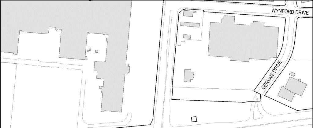
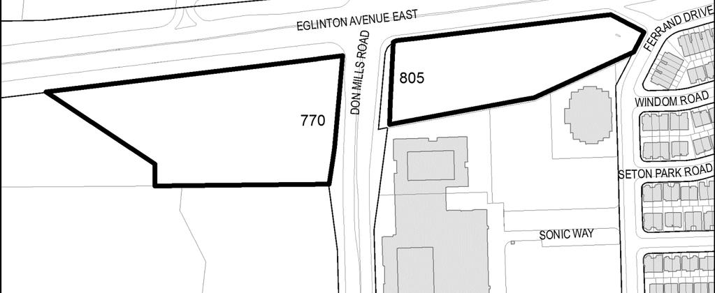
33 Attachment 2: Location Map Page 33 of 50


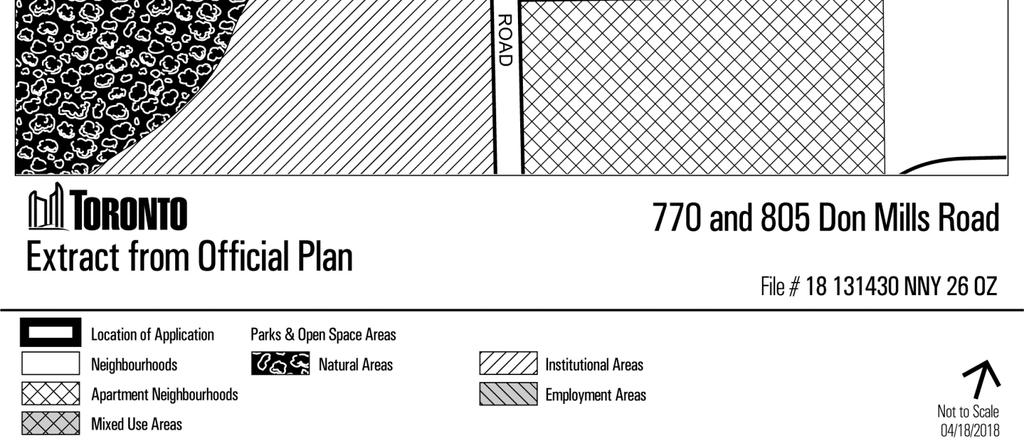
34 Attachment 3: Official Plan Land Use Map Page 34 of 50
35 Attachment 4A: Existing Zoning By-law Map (former North York Zoning By-law 7625) Page 35 of 50

 Page 36 of")
36 Attachment 4B: Zoning By-law Map (City of Toronto Zoning By-law ) Page 36 of 50
37 Attachment 5A: Site Plan 770 Don Mills Road Page 37 of 50
38 Attachment 5B: Site Plan 805 Don Mills Road Page 38 of 50
39 Attachment 6A: Ground Floor Plan 770 Don Mills Road Page 39 of 50
40 Attachment 6B: Ground Floor Plan 805 Don Mills Road Page 40 of 50
41 Attachment 7A: South Elevation 770 Don Mills Road Page 41 of 50
42 Attachment 7B: North Elevation 770 Don Mills Road Page 42 of 50
43 Attachment 7C: East Elevation 770 Don Mills Road Page 43 of 50
44 Attachment 7D: West Elevation 770 Don Mills Road Page 44 of 50
45 Attachment 8A: South Elevation 805 Don Mills Road Page 45 of 50
46 Attachment 8B: North Elevation 805 Don Mills Road Page 46 of 50
47 Attachment 8C: East Elevation 805 Don Mills Road Page 47 of 50
48 Attachment 8D: West Elevation 805 Don Mills Road Page 48 of 50


49 Attachment 9A: 3D View from Southwest Don Mills Road Page 49 of 50


50 Attachment 9B: 3D View from Southeast Don Mills Road Page 50 of 50
Official Plan Review: Draft Built Form Policies
 PG.30.1 REPORT FOR ACTION Official Plan Review: Draft Built Form Policies Date: May 15, 2018 To: Planning and Growth Management Committee From: Chief Planner and Executive Director, City Planning Division
Bloor St. W. Rezoning - Preliminary Report
 STAFF REPORT ACTION REQUIRED 1638-1644 Bloor St. W. Rezoning - Preliminary Report Date: April 1, 2008 To: From: Wards: Reference Number: Toronto and East York Community Council Acting Director, Community
and Richmond Street West - Official Plan Amendment Application - Preliminary Report
 STAFF REPORT ACTION REQUIRED 822-838 and 860-862 Richmond Street West - Official Plan Amendment Application - Preliminary Report Date: August 14, 2017 To: From: Wards: Reference Number: Toronto and East
30 and 44 Zorra Street - Zoning By-law Amendment Application - Preliminary Report
 STAFF REPORT ACTION REQUIRED 30 and 44 Zorra Street - Zoning By-law Amendment Application - Preliminary Report Date: March 14, 2016 To: From: Wards: Reference Number: Etobicoke York Community Council Director,
1071 King Street West Zoning Amendment Application - Preliminary Report
 STAFF REPORT ACTION REQUIRED 1071 King Street West Zoning Amendment Application - Preliminary Report Date: August 9, 2012 To: From: Wards: Reference Number: Toronto and East York Community Council Director,
Eglinton Avenue East & 50 Thermos Road - Official Plan Amendment Application Preliminary Report
 STAFF REPORT ACTION REQUIRED 1966 2050 Eglinton Avenue East & 50 Thermos Road - Official Plan Amendment Application Preliminary Report Date: March 15, 2016 To: From: Wards: Reference Number: Scarborough
599 Kennedy Road - Official Plan Amendment and Zoning Amendment Application - Preliminary Report
 STAFF REPORT ACTION REQUIRED 599 Kennedy Road - Official Plan Amendment and Zoning Amendment Application - Preliminary Report Date: March 7, 2017 To: From: Wards: Reference Number: Scarborough Community
4780 Eglinton Avenue West - Zoning By-law Amendment and Draft Plan of Subdivision Applications - Preliminary Report
 STAFF REPORT ACTION REQUIRED 4780 Eglinton Avenue West - Zoning By-law Amendment and Draft Plan of Subdivision Applications - Preliminary Report Date: May 29, 2014 To: From: Wards: Reference Number: Etobicoke
10 Park Lawn Rd - Zoning Amendment Application- Preliminary Report
 STAFF REPORT ACTION REQUIRED 10 Park Lawn Rd - Zoning Amendment Application- Preliminary Report Date: March 9, 2012 To: From: Wards: Reference Number: Etobicoke York Community Council Director, Community
5959 Yonge Street Rezoning Application - Preliminary Report
 STAFF REPORT ACTION REQUIRED 5959 Yonge Street Rezoning Application - Preliminary Report Date: February 23, 2011 To: From: Wards: Reference Number: North York Community Council Director, Community Planning,
844 Don Mills Road & 1150 Eglinton Avenue East - Official Plan Amendment Application - Preliminary Report
 STAFF REPORT ACTION REQUIRED 844 Don Mills Road & 1150 Eglinton Avenue East - Official Plan Amendment Application - Preliminary Report Date: July 10, 2014 To: From: Wards: Reference Number: Planning and
The West Vaughan Employment Area Secondary Plan Policies
 Part 2: The West Vaughan Employment Area Secondary Plan Policies 2.1 General Policies It is the policy of Council: 2.1.1. That the West Vaughan Employment Area (the WVEA), identified on Schedule 1, will
Welcome. Walk Around. Talk to Us. Write Down Your Comments
 Welcome This is an information meeting introducing the applications for proposed redevelopment of the Yorkdale Shopping Centre site at 3401 Dufferin Street and 1 Yorkdale Road over the next 20+ years,
Planning and Growth Management Committee. Chief Planner and Executive Director, City Planning Division. Pg12013 (File No NNY 34 OZ)
") 865 York Mills Road Official Plan Amendment Application Preliminary Report STAFF REPORT ACTION REQUIRED Date: February 28, 2012 To: From: Wards: Reference Number: Planning and Growth Management Committee
865 York Mills Road Official Plan Amendment Application Preliminary Report STAFF REPORT ACTION REQUIRED Date: February 28, 2012 To: From: Wards: Reference Number: Planning and Growth Management Committee
808 Mount Pleasant Road Zoning Amendment Application Request for Interim Direction Report
 STAFF REPORT ACTION REQUIRED 808 Mount Pleasant Road Zoning Amendment Application Request for Interim Direction Report Date: June 15, 2018 To: From: Wards: Reference Number: Toronto and East York Community
CONTENTS 8.0 LAND USE 8.1 GENERAL LAND USE 8.2 RESIDENTIAL 8.3 MIXED USE 8.4 COMMERCIAL 8.5 EMPLOYMENT LANDS
 8-2 Land Use 8.0 LAND USE CONTENTS 8.1 GENERAL LAND USE 8.1.1 Uses provided for in all Land Use Designations 8.1.2 Uses prohibited in Hazardous Lands, Hazardous Sites and Special Policy Areas 8.1.3 Uses
QUEEN-RIVER SECONDARY PLAN
 34 QUEEN-RIVER SECONDARY PLAN 34. QUEEN RIVER SECONDARY PLAN 1. INTRODUCTION The Queen-River area is approximately 6.4 hectares and is located at the eastern edge of the Downtown as shown on Map 34-1.
393, 395, 397, 399, 401 and 403 Spring Garden Avenue Official Plan and Zoning By-law Amendment Application Preliminary Report
 STAFF REPORT ACTION REQUIRED 393, 395, 397, 399, 401 and 403 Spring Garden Avenue Official Plan and Zoning By-law Amendment Application Preliminary Report Date: March 29, 2010 To: From: Wards: Reference
646 Kingston Road - Official Plan Amendment and Zoning Amendment Applications - Preliminary Report
 STAFF REPORT ACTION REQUIRED 646 Kingston Road - Official Plan Amendment and Zoning Amendment Applications - Preliminary Report Date: December 8, 2014 To: From: Wards: Reference Number: Toronto and East
Queen Street West - Zoning Amendment Application - Preliminary Report
 STAFF REPORT ACTION REQUIRED 944-952 Queen Street West - Zoning Amendment Application - Preliminary Report Date: February 6, 2013 To: From: Wards: Reference Number: Toronto and East York Community Council
YONGE STEELES CORRIDOR SECONDARY PLAN. Young + Wright / IBI Group Architects Dillon Consulting Ltd. GHK International (Canada) Ltd.
 Ltd.") PART A: PREAMBLE 1.0 PURPOSE The purpose of this Secondary Plan is to provide a development framework for intensification of the Yonge/ Steeles corridor including the north side of Steeles Avenue West
PART A: PREAMBLE 1.0 PURPOSE The purpose of this Secondary Plan is to provide a development framework for intensification of the Yonge/ Steeles corridor including the north side of Steeles Avenue West
1296 Kennedy Road - Zoning Amendment Application - Preliminary Report
 STAFF REPORT ACTION REQUIRED 1296 Kennedy Road - Zoning Amendment Application - Preliminary Report Date: January 15, 2016 To: From: Wards: Reference Number: Scarborough Community Council Acting Director,
DRAFT Northeast Quadrant of Kipling Avenue and Highway 7 DRAFT AUGUST 29, Goals Land Use. The goals of this Plan are to:
 AUGUST 29, 2017 12.15 Northeast Quadrant of Kipling Avenue and Highway 7 12.15.1 Goals 12.15.2 Land Use The goals of this Plan are to: 12.15.2.1 General Provisions: a) Ensure the development of a compact
2494 Danforth Avenue - Official Plan Amendment and Zoning Amendment Application - Preliminary Report
 STAFF REPORT ACTION REQUIRED 2494 Danforth Avenue - Official Plan Amendment and Zoning Amendment Application - Preliminary Report Date: March 15, 2018 To: From: Wards: Reference Number: Toronto and East
2370 Finch Avenue West - Official Plan and Zoning Bylaw Amendment Application Request for Interim Directions Report
 REPORT FOR ACTION 2370 Finch Avenue West - Official Plan and Zoning Bylaw Amendment Application Request for Interim Directions Report Date: June 14, 2018 To: Etobicoke York Community Council From: Director,
280 Manse Road - Official Plan Amendment, Zoning Amendment, Draft Plan of Subdivision Applications - Preliminary Report
 STAFF REPORT ACTION REQUIRED 280 Manse Road - Official Plan Amendment, Zoning Amendment, Draft Plan of Subdivision Applications - Preliminary Report Date: March 11, 2014 To: From: Wards: Reference Number:
4155 Yonge Street Official Plan Amendment and Rezoning Application Preliminary Report
 STAFF REPORT ACTION REQUIRED 4155 Yonge Street Official Plan Amendment and Rezoning Application Preliminary Report Date: May 5, 2011 To: From: Wards: Reference Number: North York Community Council Director,
2161 Yonge Street - Zoning Amendment Application - Preliminary Report
 STAFF REPORT ACTION REQUIRED 2161 Yonge Street - Zoning Amendment Application - Preliminary Report Date: September 29, 2017 To: From: Wards: Reference Number: Toronto and East York Community Council Director,
7437, 7439 and 7441 Kingston Road - Zoning By-law Amendment and Site Plan Control Applications - Preliminary Report
 STAFF REPORT ACTION REQUIRED 7437, 7439 and 7441 Kingston Road - Zoning By-law Amendment and Site Plan Control Applications - Preliminary Report Date: August 13, 2015 To: From: Wards: Reference Number:
PUBLIC OPEN HOUSE HURONTARIO-MAIN CORRIDOR SECONDARY PLAN
 PUBLIC OPEN HOUSE HURONTARIO-MAIN CORRIDOR SECONDARY PLAN Tuesday, February 28, 2012 6pm 9pm 1 st Floor Atrium, City Hall 2 Wellington Street West, Brampton 1 POLICY FRAMEWORK The 2006 Provincial Growth
Don Mills Crossing Study and Celestica Lands Development Application Community Meeting, Open House, and Breakout Discussions
 Consultation Summary Don Mills Crossing Study and Celestica Lands Development Application Community Meeting, Open House, and Breakout Discussions This report is not intended to provide a verbatim transcript
523, 525 and 525A Adelaide Street West - Zoning Amendment Application - Preliminary Report
 STAFF REPORT ACTION REQUIRED 523, 525 and 525A Adelaide Street West - Zoning Amendment Application - Preliminary Report Date: May 12, 2012 To: From: Wards: Reference Number: Toronto and East York Community
1350 Ellesmere Road and 1560 Brimley Road Zoning Amendment Application - Preliminary Report
 STAFF REPORT ACTION REQUIRED 1350 Ellesmere Road and 1560 Brimley Road Zoning Amendment Application - Preliminary Report Date: December 6, 2017 To: From: Wards: Reference Number: Scarborough Community
THE CITY OF VAUGHAN BY-LAW BY-LAW NUMBER A By-law to adopt Amendment Number 1 to the Official Plan of the Vaughan Planning Area.
 THE CITY OF VAUGHAN BY-LAW BY-LAW NUMBER 015-2014 A By-law to adopt Amendment Number 1 to the Official Plan of the Vaughan Planning Area. NOW THEREFORE the Council of the Corporation of the City of Vaughan
1-17 Anndale Drive, Bales Avenue and Glendora Avenue Zoning Amendment Application Preliminary Report
 STAFF REPORT ACTION REQUIRED 1-17 Anndale Drive, 31-35 Bales Avenue and 22-70 Glendora Avenue Zoning Amendment Application Preliminary Report Date: August 20, 2007 To: From: Wards: Reference Number: North
2450 Victoria Park Avenue Official Plan Amendment Application Preliminary Report
 STAFF REPORT ACTION REQUIRED 2450 Victoria Park Avenue Official Plan Amendment Application Preliminary Report Date: December 19, 2012 To: From: Wards: Reference Number: Planning and Growth Management Committee
Director, Community Planning, Etobicoke York District
 STAFF REPORT ACTION REQUIRED Baby Point Gates Planning Study 227-430 Jane Street, 665-685 Annette Street, 494 Armadale Avenue, 143 Evans Avenue and 502 504 Willard Avenue Status Report Date: August 11,
STAFF REPORT. December 20, North York Community Council. Director, Community Planning, North York District
 STAFF REPORT December 20, 2005 To: From: Subject: North York Community Council Director, Community Planning, North York District Preliminary Report Application to Amend the Official Plan and Zoning By-law
From: Director, Community Planning, Etobicoke York District
 STAFF REPORT ACTION REQUIRED 4208, 4210 and 4214 Dundas Street West - Official Plan Amendment and Zoning By-law Amendment Application - Preliminary Report Date: July 22, 2014 To: Etobicoke York Community
150 Eighth Street Zoning By-law Amendment Application Preliminary Report
 REPORT FOR ACTION 150 Eighth Street Zoning By-law Amendment Application Preliminary Report Date: March 27, 2019 To: Etobicoke York Community Council From: Director, Community Planning, Etobicoke York District
8 Oak Street - Official Plan and Zoning By-law Amendment Application - Preliminary Report
 STAFF REPORT ACTION REQUIRED 8 Oak Street - Official Plan and Zoning By-law Amendment Application - Preliminary Report Date: March 17, 2014 To: From: Wards: Reference Number: Planning and Growth Management
4800 Yonge Street - Official Plan Amendment, Zoning Amendment and Site Plan Applications - Request for Direction Report
 STAFF REPORT ACTION REQUIRED 4800 Yonge Street - Official Plan Amendment, Zoning Amendment and Site Plan Applications - Request for Direction Report Date: April 16, 2018 To: From: Wards: Reference Number:
Clairtrell Area Context Plan
 Clairtrell Area Context Plan March 2005 Urban Development Services City Planning Contents 1. Introduction... 4 2. Development Structure... 6 2.1 Streets... 7 2.1.1 Sheppard Avenue and Bayview Avenue...
PORT WHITBY COMMUNITY
 PORT WHITBY COMMUNITY SECONDARY PLAN UPDATE COMMUNITY IMPROVEMENT PLAN URBAN DESIGN GUIDELINES September 2015 DRAFT PROPOSED AMENDMENT NUMBER # to the Whitby Official Plan PURPOSE: The intent of this Amendment
333 College Street and 303 Augusta Avenue - Official Plan Amendment, Zoning Amendment Applications - Preliminary Report
 STAFF REPORT ACTION REQUIRED 333 College Street and 303 Augusta Avenue - Official Plan Amendment, Zoning Amendment Applications - Preliminary Report Date: March 12, 2015 To: From: Wards: Reference Number:
ELMVALE ACRES SHOPPING CENTRE MASTER PLAN
 ELMVALE ACRES SHOPPING CENTRE MASTER PLAN Contents 1.0 INTRODUCTION... 2 2.0 LOCATION... 2 3.0 EXISTING CONTEXT... 2 4.0 VISION & GUIDING PRINCIPLES... 2 5.0 LAND USE AND BUILT FORM... 4 5.1 St. Laurent
13 THORNHILL YONGE STREET STUDY IMPLEMENTATION CITY OF VAUGHAN OPA 669 AND TOWN OF MARKHAM OPA 154
 13 THORNHILL YONGE STREET STUDY IMPLEMENTATION CITY OF VAUGHAN OPA 669 AND TOWN OF MARKHAM OPA 154 The Planning and Economic Development Committee recommends the adoption of the recommendations contained
1151 Queen Street East - Zoning Amendment Application - Preliminary Report
 STAFF REPORT ACTION REQUIRED 1151 Queen Street East - Zoning Amendment Application - Preliminary Report Date: June 12, 2018 To: From: Wards: Reference Number: Toronto and East York Community Council Acting
Welcome to the Oakridge Centre Open House
 Welcome to the Oakridge Centre Open House Why is the City hosting this event? This open house is to inform you of a rezoning application submitted to the City of Vancouver to amend the existing CD-1 (Comprehensive
Main Street - Zoning Amendment Application - Preliminary Report
 STAFF REPORT ACTION REQUIRED 286-294 Main Street - Zoning Amendment Application - Preliminary Report Date: September 29, 2017 To: From: Wards: Reference Number: Toronto and East York Community Council
4569 Kingston Road Zoning Amendment Application - Preliminary Report
 STAFF REPORT ACTION REQUIRED 4569 Kingston Road Zoning Amendment Application - Preliminary Report Date: August 4, 2016 To: From: Wards: Reference Number: Scarborough Community Council Acting Director,
Urban Design Manual PLANNING AROUND RAPID TRANSIT STATIONS (PARTS) Introduction. Station Study Areas
 Introduction. Station Study Areas") 111111 PLANNING AROUND RAPID TRANSIT STATIONS (PARTS) Introduction The ION rapid transit system will link Waterloo, Kitchener and Cambridge through a central transit corridor (CTC). There are a number
111111 PLANNING AROUND RAPID TRANSIT STATIONS (PARTS) Introduction The ION rapid transit system will link Waterloo, Kitchener and Cambridge through a central transit corridor (CTC). There are a number
1141 Bloor Street West, 980 Dufferin Street, and 90 Croatia Street Combined Official Plan and Zoning Amendment Application - Preliminary Report
 STAFF REPORT ACTION REQUIRED 1141 Bloor Street West, 980 Dufferin Street, and 90 Croatia Street Combined Official Plan and Zoning Amendment Application - Preliminary Report Date: January 30, 2018 To: From:
St. Lawrence Neighbourhood Focused Area - Official Plan Amendment Status Report
 STAFF REPORT ACTION REQUIRED St. Lawrence Neighbourhood Focused Area - Official Plan Amendment Status Report Date: May 21, 2015 To: From: Wards: Reference Number: Toronto and East York Community Council
URBAN DESIGN BRIEF URBAN DESIGN BRIEF 721 FRANKLIN BLVD, CAMBRIDGE August 2018
 URBAN DESIGN BRIEF URBAN DESIGN BRIEF 721 FRANKLIN BLVD, CAMBRIDGE August 2018 DESIGN BRIEF CONTENTS PART A 1.0 INTRODUCTION 2.0 DESCRIPTION & ANALYSIS OF SITE CONTEXT 3.0 DESIGN CONSTRAINTS AND OPPORTUNITIES
Trafalgar Road Corridor Planning Study Open House
 Trafalgar Road Corridor Planning Study Open House June 24, 2013 6:30-8:30 p.m. Oakville & Trafalgar Rooms Overview The Livable Oakville Plan identifies the lands along Trafalgar Road, between the QEW and
*** DRAFT 2 FOR PUBLIC REVIEW ***
 6.7 The area is generally bounded by the Red Hill Valley Parkway to the west, Lake Avenue to the east, the Queen Elizabeth Way (QEW) to the north, and by the properties just south of Queenston Road to
Official Plan Review
 Official Plan Review Summary Report - The Built Environment August 2014 Part 1: Introduction Planning for a healthy, prosperous and sustainable community is an important goal for our municipality. From
70 and 80 Wicksteed Avenue, 202, 204 and 206. Parkhurst Boulevard and 99 Vanderhoof Avenue
 STAFF REPORT ACTION REQUIRED 70 and 80 Wicksteed Avenue, 202, 204 and 206 Zoning By-law Amendment Application Preliminary Report Date: December 13, 2011 To: From: Wards: Reference Number: North York Community
CREATE A VIBRANT MIXED-USE COMMUNITY
 CREATE A VIBRANT MIXED-USE COMMUNITY Land Use Public Realm Plan Built Form Heritage Tell us what you think! Place a sticky note here or leave us a comment form LAND USE The land use framework of this Secondary
178 Carruthers Properties Inc.
 178 Carruthers Properties Inc. Planning Rationale for 178 Carruthers Avenue Site Plan Control Application June 2014 Table of Contents 1.0 Introduction 2.0 Overview of Subject Property 3.0 Current Zoning
DRAFT DRAFT DRAFT DRAFT
 # 19 EXPAND GREEN AND OPEN SPACES AND COMMUNITY FACILITIES IN TANDEM WITH NEW DEVELOPMENT The role of Eglinton will change in the coming years, along with the intensity of activity and land uses. As more
2901 Bayview Avenue and 630 Sheppard Avenue East - Official Plan Amendment and Zoning Amendment Application - Preliminary Report
 STAFF REPORT ACTION REQUIRED 2901 Bayview Avenue and 630 Sheppard Avenue East - Official Plan Amendment and Zoning Amendment Application - Preliminary Report Date: September 27, 2017 To: From: Wards: Reference
240 and 242 Finch Avenue West Zoning By-law Amendment Application Preliminary Report
 REPORT FOR ACTION 240 and 242 Finch Avenue West Zoning By-law Amendment Application Preliminary Report Date: March 1, 2019 To: North York Community Council From: Director, Community Planning, North York
FORMER CANADIAN FORCES BASE (CFB) ROCKCLIFFE SECONDARY PLAN. Official Plan Amendment XX to the Official Plan for the City of Ottawa
 ROCKCLIFFE SECONDARY PLAN. Official Plan Amendment XX to the Official Plan for the City of Ottawa") FORMER CANADIAN FORCES BASE (CFB) ROCKCLIFFE SECONDARY PLAN Official Plan Amendment XX to the Official Plan for the City of Ottawa 1 INDEX THE STATEMENT OF COMPONENTS PART A THE PREAMBLE PAGE Purpose...
FORMER CANADIAN FORCES BASE (CFB) ROCKCLIFFE SECONDARY PLAN Official Plan Amendment XX to the Official Plan for the City of Ottawa 1 INDEX THE STATEMENT OF COMPONENTS PART A THE PREAMBLE PAGE Purpose...
Bayview Avenue Official Plan Amendment, Zoning Amendment and Site Plan Control Applications Request for Direction Report
 STAFF REPORT ACTION REQUIRED 2425 2427 Bayview Avenue Official Plan Amendment, Zoning Amendment and Site Plan Control Applications Request for Direction Report Date: May 28, 2015 To: From: Wards: Reference
URBAN DESIGN BRIEF. 2136&2148 Trafalgar Road. Town of Oakville
 URBAN DESIGN BRIEF 2136&2148 Trafalgar Road Town of Oakville Prepared By: METROPOLITAN CONSULTING INC For 2500674 Ontario Inc November 2016 TABLE OF CONTENTS Page No. 1.0 Introduction/Description of Subject
Yonge Street Zoning Amendment Application - Preliminary Report
 STAFF REPORT ACTION REQUIRED 341-355 Yonge Street Zoning Amendment Application - Preliminary Report Date: March 24, 2011 To: From: Wards: Reference Number: Toronto and East York Community Council Director,
TABLE OF CONTENTS 1.0 INTRODUCTION... 3
 TABLE OF CONTENTS 1.0 INTRODUCTION... 3 1.1. BACKGROUND... 3 1.2. THE PROPOSAL... 5 2.0 EXISTING POLICY FRAMEWORK... 5 2.1. PROVINCIAL POLICY STATEMENT (PPS)... 5 2.2. CITY OF LONDON OFFICIAL PLAN (OP)...
Uptown Rideau Street Secondary Plan [Amendment #166, January 12, 2016]
![Uptown Rideau Street Secondary Plan [Amendment #166, January 12, 2016]](/thumbs/76/73760497.jpg "Uptown Rideau Street Secondary Plan [Amendment #166, January 12, 2016]") [Amendment #166, January 12, 2016] The policies of this Secondary Plan are in effect, save and except for the property at 560 Rideau Street, for which there remains a site specific appeal to this Secondary
[Amendment #166, January 12, 2016] The policies of this Secondary Plan are in effect, save and except for the property at 560 Rideau Street, for which there remains a site specific appeal to this Secondary
CONTENTS 2.0 A FRAMEWORK FOR SUSTAINABLE GROWTH 2.1 MANAGING SUSTAINABLE GROWTH THE VISION TO GOALS AND OBJECTIVES 2.3 MARKHAM STRUCTURE
 2 A Framework for Sustainable Growth 2.0 A FRAMEWORK FOR SUSTAINABLE GROWTH CONTENTS 2.1 MANAGING SUSTAINABLE GROWTH THE VISION TO 2031 2.2 GOALS AND OBJECTIVES 2.2.1 Protecting the Natural Environment
SCARBOROUGH SUBWAY EXTENSION. Scarborough Subway Extension. Final Terms of Reference
 Scarborough Subway Extension Final Terms of Reference 1 1.0 Introduction and Background 1.1 Introduction Toronto City Council recently confirmed support for an extension of the Bloor-Danforth Subway from
1 Eglinton Avenue East Zoning Amendment Application Final Report
 STAFF REPORT ACTION REQUIRED 1 Eglinton Avenue East Zoning Amendment Application Final Report Date: September 29, 2017 To: From: Wards: Reference Number: Toronto and East York Community Council Director,
2655 Lawrence Ave East - Rezoning Application - Preliminary Report
 STAFF REPORT ACTION REQUIRED 2655 Lawrence Ave East - Rezoning Application - Preliminary Report Date: June 17, 2008 To: From: Wards: Reference Number: Scarborough Community Council Director, Community
1.3 TRANSIT VISION 2040 FROM VISION TO ACTION THEME 1: PUTTING TRANSIT AT THE CENTRE OF COMMUNITIES. Fully integrate transit with community planning
 TRANSIT VISION 2040 FROM VISION TO ACTION TRANSIT VISION 2040 defines a future in which public transit maximizes its contribution to quality of life with benefits that support a vibrant and equitable society,
251 Manitoba Street- Official Plan Amendment and Zoning By-law Amendment Application- Preliminary Report
 STAFF REPORT ACTION REQUIRED 251 Manitoba Street- Official Plan Amendment and Zoning By-law Amendment Application- Preliminary Report Date: February 5, 2014 To: From: Wards: Reference Number: Etobicoke
60-64 Queen Street East and Church Street - Zoning Amendment Application - Preliminary Report
 STAFF REPORT ACTION REQUIRED 60-64 Queen Street East and 131-135 Church Street - Zoning Amendment Application - Preliminary Report Date: March 15, 2018 To: From: Wards: Reference Number: Toronto and East
350, 370, and 390 Queens Quay West Official Plan Amendment and Zoning Amendment Applications - Preliminary Report
 STAFF REPORT ACTION REQUIRED 350, 370, and 390 Queens Quay West Official Plan Amendment and Zoning Amendment Applications - Preliminary Report Date: April 22, 2016 To: From: Wards: Reference Number: Toronto
[PLANNING RATIONALE] For Site Plan Control and Lifting of Holding Zone By-Law 101 Champagne Avenue. May 23, 2014
![[PLANNING RATIONALE] For Site Plan Control and Lifting of Holding Zone By-Law 101 Champagne Avenue. May 23, 2014](/thumbs/75/71599615.jpg "[PLANNING RATIONALE] For Site Plan Control and Lifting of Holding Zone By-Law 101 Champagne Avenue. May 23, 2014") [PLANNING RATIONALE] For Site Plan Control and Lifting of Holding Zone By-Law 101 Champagne Avenue May 23, 2014 Contents 1.0 Introduction... 2 2.0 Site Context... 2 2.1 Adjacent Uses... 2 Figure 1: Site
[PLANNING RATIONALE] For Site Plan Control and Lifting of Holding Zone By-Law 101 Champagne Avenue May 23, 2014 Contents 1.0 Introduction... 2 2.0 Site Context... 2 2.1 Adjacent Uses... 2 Figure 1: Site
2.0 A FRAMEWORK FOR SUSTAINABLE GROWTH CONTENTS
 2-2 A Framework for Sustainable Growth 2.0 A FRAMEWORK FOR SUSTAINABLE GROWTH CONTENTS 2.1 MANAGING SUSTAINABLE GROWTH THE VISION TO 2031 2.2 GOALS AND OBJECTIVES 2.2.1 Protecting the Natural Environment
Director, Community Planning, North York District
 STAFF REPORT ACTION REQUIRED 36 and 37 Jane Osler Boulevard and 42 and 44 Cartwright Avenue Zoning By-law Amendment and Draft Plan of Subdivision Approval Applications - Preliminary Report Date: May 22,
71 75 Curlew Drive - Zoning Amendment Application - Preliminary Report
 STAFF REPORT ACTION REQUIRED 71 75 Curlew Drive - Zoning Amendment Application - Preliminary Report Date: May 19, 2017 To: From: Wards: Reference Number: North York Community Council Director, Community
Figure 1- Site Plan Concept
 Figure 1- Site Plan Concept Parking will be provided underground on three levels at rate of 1.0 space/ unit; this rate includes all visitors parking. MMM Group has prepared a parking assessment (April,
Director, Community Planning, North York District
 STAFF REPORT ACTION REQUIRED 5925 5997 Yonge Street, 11 25 Wedgewood Drive, 1 8 Doverwood Court, and 42 54 Cummer Avenue Official Plan Amendment Application Request for Direction Report Date: April 21,
Bank Street Secondary Plan
 1.1 Introduction The is a guide to the long term design and development of the portion of Bank Street between Riverside Drive and Ledbury Park, and provides direction on land use, built form, design, parking,
City of Toronto Official Plan Indicators
 City of Toronto Official Plan Indicators Attachment 1 2017 Gladki Planning Associates in association with Hemson Consulting & Studio Jaywall City of Toronto Official Plan Indicators 1 Introduction What
and services The protection and conservation of environmentally significant and sensitive natural heritage features and functions.
 6. Land Use 6.0 Preamble A healthy and livable city is one in which people can enjoy a vibrant economy and a sustainable healthy environment in safe, caring and diverse neighbourhoods. In order to ensure
WELCOME and introduction
 1 WELCOME and introduction Mobility Hub Locations within Burlington STUDY OVERVIEW STUDY OBJECTIVES The City of Burlington is developing four Area Specific Plans, one for each of Burlington s Mobility
112 College Street Zoning Amendment Application Preliminary Report
 ~TORONTO REPORT FOR ACTION 112 College Street Zoning Amendment Application Preliminary Report Date: January 25, 2019 To: Toronto and East York Community Council From: Director, Community Planning, Toronto
Land Use Amendment in Southwood (Ward 11) at and Elbow Drive SW, LOC
 at and Elbow Drive SW, LOC") 2018 November 15 Page 1 of 10 EXECUTIVE SUMMARY This land use amendment application was submitted by Rick Balbi Architect on 2017 August 31 on behalf of Sable Developments Ltd, and with authorization from
2018 November 15 Page 1 of 10 EXECUTIVE SUMMARY This land use amendment application was submitted by Rick Balbi Architect on 2017 August 31 on behalf of Sable Developments Ltd, and with authorization from
AGINCOURT SECONDARY PLAN
 1 AGINCOURT SECONDARY PLAN 1. AGINCOURT SECONDARY PLAN The following policies and principles apply to the area herein referred to as Agincourt, as outlined on Map 1-1. 1. GENERAL POLICIES 1.1 This Secondary
This report presents the draft Don Mills Crossing Secondary Plan for public consultation.
 PG30.6 REPORT FOR ACTION Don Mills Crossing - Proposals Report Date: May 17, 2018 To: Planning and Growth Management Committee From: Chief Planner and Executive Director, City Planning Division Wards:
Stanley Greene District Downsview (80 Carl Hall Road) Zoning By-law Amendment and Draft Plan of Subdivision Applications Request for Direction Report
 Zoning By-law Amendment and Draft Plan of Subdivision Applications Request for Direction Report") STAFF REPORT ACTION REQUIRED Stanley Greene District Downsview (80 Carl Hall Road) Zoning By-law Amendment and Draft Plan of Subdivision Applications Request for Direction Report Date: December 16, 2011
STAFF REPORT ACTION REQUIRED Stanley Greene District Downsview (80 Carl Hall Road) Zoning By-law Amendment and Draft Plan of Subdivision Applications Request for Direction Report Date: December 16, 2011
Director, Community Planning, North York District
 STAFF REPORT ACTION REQUIRED 35 Carl Hall Rd, 0 Keele St E/S, 0 Allen Road W/S, 0 Dufferin St W/S, 1035 Sheppard Ave W, 64 Murray Rd, 0 Wilson Ave S/S, 0 Wilson Ave N/S, 160 Transit Rd, 0 Plewes Rd N/S,
Wellington Street West - Zoning Amendment Application - Preliminary Report
 STAFF REPORT ACTION REQUIRED 485-489 Wellington Street West - Zoning Amendment Application - Preliminary Report Date: September 26, 2016 To: From: Wards: Reference Number: Toronto and East York Community
1 Introduction. Chapter. In this chapter:
 Chapter 1 Introduction In this chapter: 1.1 A Snapshot of the Region 1.2 Towards a Sustainable Region 1.3 The Provincial Context 1.4 Purpose and Organization The Regional Municipality of York Official
Mark-up of the effect of the proposed Bronte Village Growth Area OPA No.18 on the text of section 24, Bronte Village, of the Livable Oakville Plan
 Mark-up of the effect of the proposed Bronte Village Growth Area OPA No.18 on the text of section 24, Bronte Village, of the Livable Oakville Plan Notes: This document is provided for information purposes
Sustainable Growth. Sustainable Growth
 2 Sustainable Growth Sustainable Growth SUSTAINABLE GROWTH 2.1 COMMUNITY VISION... 2-5 2.2 THE CITY SYSTEM... 2-7 2.2.1 AREAS... 2-7 2.2.2 CITY-WIDE SYSTEMS... 2-8 2.2.3 PROVINCIAL PLAN BOUNDARIES AND
4121 Lawrence Avenue East Rezoning Application Preliminary Report
 STAFF REPORT ACTION REQUIRED 4121 Lawrence Avenue East Rezoning Application Preliminary Report Date: October 11, 2011 To: From: Wards: Reference Number: Scarborough Community Council Director, Community
1.0 Purpose of a Secondary Plan for the Masonville Transit Village
 Report to Planning and Environment Committee To: Chair and Members Planning & Environment Committee From: John M. Fleming Managing Director, Planning and City Planner Subject: Masonville Transit Village