SITE PLAN REVIEW COMMITTEE MEETING AGENDA & STAFF REPORT. DATE: Monday, January 9, :00 10:00 p.m. PLACE:
|
|
|
- Gary Phillips
- 5 years ago
- Views:
Transcription
1 SITE PLAN REVIEW COMMITTEE MEETING AGENDA & STAFF REPORT DATE: Monday, January 9, 2017 TIME: 7:00 10:00 p.m. PLACE: 2100 Clarendon Boulevard Courthouse Plaza Room 109/110 (Cherry & Dogwood) Arlington, VA SPRC STAFF COORDINATOR: Samia Byrd, Item Wilson Boulevard (SP #445) 7:00pm 8:25pm (RPC# , -009, -010, -011, -012, -013, -014, -016, -017, -018, -021, and -022) Planning Commission and County Board meetings scheduled for February Samia Byrd (CPHD Staff) Item 2. WRAP Implementation 8:35pm-10:00pm The Site Plan Review Committee (SPRC) is comprised of Planning Commission members, representatives from other relevant commissions and several appointed citizens. The SPRC reviews all site plans and major site plan amendments requests, which are submitted to the County Board and the Planning Commission for consideration. The major responsibilities of the SPRC are the following: 1. Review site plan or major site plan amendment requests in detail. 2. Advise the Planning Commission by recommending the appropriate action in regard to a specific plan and any conditions, which it might determine to be necessary or appropriate. 3. Provide a forum by which interested citizens, civic associations and neighborhood conservation committees can review and comment on a particular plan, or the effects that the proposed project might have on the neighborhood. In order to save copying costs, staff has selectively chosen the reduced drawings to be included in this package. The complete full size drawings are available for review in the Arlington County Zoning Office, 10 th Floor, Courthouse Plaza, 2100 Clarendon Boulevard and also in the Central Library s Virginia Room, 1015 N. Quincy St., (703) For more information on the Arlington County Planning Commission, go to their web site For more information on the Site Plan public review process, go to the Arlington County Planning Division s web site on Development Proposals/Site Plans plansmain.aspx To view the current Site Plan Review Committee schedule, go to the web site
2 Page 2 Agenda: Meeting #1, November 14, ) Introduction (SPRC Chair) a) SPRC Overview, Scope and Agenda I T E M 1 2) Informational Presentations a) Context and Background (Staff) i) Site Plan Summary ii) WRAP Summary iii) WRAP Implementation Elements of Joint Redevelopment (1) Ground Lease (2) Development Agreement (3) Other b) Site Plan Proposal (Applicant) 3) SPRC Questions, Answers & Discussion 4) Wrap Up & Summary (SPRC, SPRC Chair) Agenda: Meeting #2, December 5, ) Meeting Agenda & Outline (SPRC Chair) 6) SPRC Review and Discussion a) Heights i) Building Form ii) Massing b) Land Use i) Uses ii) Densities iii) Retail 7) Wrap Up & Summary (SPRC Members & SPRC Chair) Agenda: Meeting #3, December 12, ) Meeting Agenda & Outline (SPRC Chair) 9) SPRC Review and Discussion a) Transportation i) Circulation (1) New Street
3 Page 3 (2) New Pedestrian Path (3) Street Cross Sections ii) Access iii) Loading iv) Parking b) Open Space & Recreation i) Rosslyn Highlands Park ii) Landscape Plan c) Urban Design i) Architecture ii) Public Realm iii) Streetscape iv) Urban Design Principles (1) Buildable Areas/Architecture/Grade Transitions (2) Service/Parking/Streetscape (3) Open Space/Recreation 10) Summary & Wrap Up (SPRC Members & SPRC Chair) Agenda: Meeting #4, January 9, ) Applicant Response to Comments & Questions 12) SPRC Review and Discussion a) Environment i) Sustainability b) Implementation i) Shared/Joint Use ii) Phasing 13) Summary & WRAP Up (SPRC Members & SPRC Chair) Site Location: 118,311 square foot site (2.72 acres) located in the West Rosslyn plan area on a portion of the super block generally bounded by 18 th Street North to the north, North Oak Street to the east, Wilson Boulevard to the south and North Quinn Street to the west. Applicant Information Developer West Rosslyn Development Company, LLC 2400 N Street, NW, #600 Washington, DC Attorney Bean, Kinney & Korman, PC 2300 Wilson Boulevard, 7th Flr. Arlington, VA Matthew G. Roberts Architect (East Building) Hickok Cole Architects st Street, NW Washington, DC Devon Perkins
4 John Kusturiss (202) Architect (West Building) Studios Architecture 1625 M Street., NW Washington, DC Brian Pilot (202) bpilot@studios.com LEED Consultant Sustainable Building Partners 2701 Prosperity Avenue, Suite 100 Fairfax, VA Mike Babcock (703) Mike.babcock@sustainbldgs.com (703) mroberts@beankinney.com Engineer Bowman Consulting 2121 Eisenhower Avenue, #302 Alexandria, VA John Lutostanski (703) jlutostanski@bowmanconsulting.com 1555 Wilson Boulevard (SP #445) Page 4 (202) dperkins@hickokcole.com Landscape Architect Lee and Associates 638 Eye Street, NW Washington, DC Rhonda Dahlkemper (202) RDahlkemper@leeandsassociates.com BACKGROUND: The Applicant, West Rosslyn Development Company, LLC (Penzance) has submitted a site plan application to redevelop the site of an existing commercial office building at 1555 Wilson Boulevard, and Fire Station No. 10 and Rosslyn Highlands Park located at 1559 Wilson Boulevard. The development proposal includes both land owned by the Applicant (1555 Wilson Boulevard) and land owned by Arlington County (1559 Wilson Boulevard). Under ground lease to the Applicant and specific terms of a Development Agreement (the Agreement ) with the County, the Applicant would incorporate into its development of the subject site, construction of a new fire station and public park among other things. The proposed site plan is submitted pursuant to a public-private partnership between the County and the Applicant in fulfillment of commitment to joint redevelopment of the subject properties. The intent of the joint redevelopment is to leverage private development as a means to offset the costs to the County of constructing a new Fire Station 10 and a redeveloped Rosslyn Highlands Park. Following is a chronological summary of events and County Board actions leading to the submission of the proposed site plan and other related development applications (rezoning and General Land Use Plan [GLUP] amendment). January 2013 Arlington County Board and Penzance Properties, LLC execute a Letter of Intent (LOI) regarding a purchase and sale agreement, and a ground lease or other such agreement for a potential public-private partnership to consolidate, subdivide, and redevelop the properties at 1555 and 1559 Wilson Boulevard with a mixed use project comprised of commercial, residential, retail and civic uses, and a public park. June of 2014 Arlington County Board initiates the West Rosslyn Area Planning Study (WRAPS) process to consider potential development scenarios for the western area of the Rosslyn Metro Station. July 21, 2015 Western Rosslyn Area Plan (WRAP) adopted by the Arlington County Board setting forth the vision and a framework for implementation of a public-private partnership that would afford the opportunity to rebuild three civic uses a fire station,
5 Page 5 school and park clustered together around new private residential, retail, and office development (WRAP, pg. 2). July 21, 2016 West Rosslyn Area Development Ground Lessee, LLC, an affiliate of Penzance enters into a ground lease with the County Board on its property at 1559 Wilson Boulevard to facilitate and outline the terms of the coordinated redevelopment of 1555 Wilson Boulevard and the County s property. November 5, 2016 The County Board and West Rosslyn Development Company, LLC enter into a Development Agreement to establish the terms and conditions for the design and construction of certain public and civic improvements for the benefit of the County on the 1555 and 1559 Wilson Boulevard properties. Future actions required by the County Board with respect to the Development Agreement include: Reciprocal Easements Agreement (REA) Firehouse Lease Agreement Use Permit for Rosslyn Highlands Park Use Permit for Fire Station 10 Use Permit for Wilson School These actions and associated applications are not subject to the proposed site plan request. Site Plan Application Summary: The Applicant proposes to rezone the properties located at 1555 and 1559 Wilson Boulevard from C-2, C-3, S3-A and RA6-15 to C-O to permit construction of two new multifamily residential buildings with ground floor retail and Fire Station 10. The buildings would be bisected by a new street running, north south through the site and frame the new Rosslyn Highlands Park. Additional information regarding the development is below. East Building 561 dwelling units 18,500 sq. ft. retail Fire Station stories (270 ft.) West Building 331 dwelling units 6,700 sq. ft. retail 23 stories (240 ft.) Below Grade Parking (1,050 Spaces) 714 residential use spaces 44 retail use spaces 24 fire station spaces 100 school use spaces

6 Page flexible use spaces 1 The following provides additional information about the site and location. Site: The 2.72-acre site is located in West Rosslyn in the middle of the block generally bounded by 18 th Street North to the north, N. Quinn Street to the west, Wilson Boulevard to the south and N. Oak Street to the east. Adjacent and surrounding land uses are as follows: To the north: To the east: To the south: To the west: Across 18 th Street North, 1530 Key Boulevard, 13-story residential building identified as the, Atrium Condominiums (SP #181); Zoned RA4.8 and designated as High-Medium Residential on the GLUP Wilson Boulevard (SP #222), 12-story commercial office building; Grocery Store (Safeway); Zoned C-O Mixed Use district and designated High Office Apartment Hotel on the GLUP. 1550, 1560 and 1600 Wilson Boulevard, six, 12 and 14-story commercial office buildings (SP #219 and SP #83); Zoned C-O Mixed Use district and designated High Office Apartment Hotel on the GLUP. Woodmont-Wilson Elementary School site; Zoned S3-A and designated Public on the GLUP. 1 The 168 flexible use spaces may be allocated for use to support condo sales, apartment rentals, retail or public parking by the Applicant based on market demands that may change over the life of the site plan.
7 Page 7 Zoning: C-2, Service Commercial-Community Business District, C-3, General Commercial District, RA6-15, Multiple Dwelling District and S3-A Special District. The site s proposed zoning is C-O Mixed Use District. General Land Use Plan Designation: High Office Apartment Hotel (up to 3.8 FAR office commercial, up to 4.8 FAR residential, and up to 3.8 FAR hotel), and Public Western Rosslyn Coordinated Redevelopment District (Note 2). A portion of the County parcel at 1559 Wilson Boulevard would be amended and designated as High Office Apartment Hotel in association with the proposed site plan. Neighborhood: North Rosslyn Civic Association; Adjacent to the Colonial Village and Radnor Fort Myer Heights Civic Associations. Existing Development: The site is currently developed with a commercial office building and parking, Fire Station 10 which includes an engine company and medic unit, and Rosslyn Highlands Park with both active and passive uses including a full-size basketball court and playground. Development Potential: Below is the development potential for the subject site based on the proposed zoning. Site Plan Area: 118,311 sf C-O By-Right C-O Site Plan C-O Site Plan Western Rosslyn Coordinated Redevelopment District TYPICAL USE One family detached; Religious Institutions (churches, mosques, synagogues, and temples); All other minor utilities; Office; Retail, Personal Services; Agriculture Uses. Office, hotel, multiple family dwelling and commercial development Office, hotel, multiple family dwelling and commercial development DENSITY ALLOWED/ MAXIMUM DEVELOPMENT 6,000 sf per Lot One-Family Dwellings: 19 Dwellings.60 FAR all other uses: 70,986 sf GFA 3.8 FAR Office, Commercial: 449,581 sf GFA 4.8 FAR Multiple Family: 567,892 sf GFA 3.8 FAR Hotel: 449,581 sf GFA 10.0 FAR Commercial, Office, Residential, Hotel: 1,183,110 sf GFA Proposed Development: The following table sets forth the preliminary statistical summary for the subject site plan. Site Area (Pre-Dedication) Site Area Allocations Retail Residential Proposed 118,311 sf ( Ac) 2,544 sf ( Ac) 115,767 sf ( Ac)
8 Page 8 Proposed Site Area (Post-Dedication) 2 117,188 sf ( Ac) Density 3 East Building 769,210 sf Residential GFA 750,710 sf Retail GFA 18,500 sf Fire Station GFA 18,637 sf West Building 413,757 sf Residential GFA 407,057 sf Retail GFA 6,700 sf Total Residential GFA 1,157,767 sf Total Retail GFA 25,200 sf Total GFA 1,182,967 sf Total Density 10.0 FAR C-O WRAP Max. Permitted GFA 1,183,110 sf C-O WRAP Max. Permitted Density 10.0 FAR Height Average Site Elevation ft East Building Main Roof Elevation ft Main Roof Height ft Penthouse Roof Elevation ft Penthouse Roof Height ft Penthouse Height 23 ft Stories 27 West Building Main Roof Elevation ft Main Roof Height ft Penthouse Roof Elevation ft Penthouse Roof Height ft Penthouse Height 23 ft Stories 23 C-O Max. Permitted Height Multiple Family ft C-O Max Permitted Height (East of New Street) ft C-O Max Permitted Height (West of New Street) ft Parking Total Parking Spaces 1,050 Residential Spaces 714 Residential Compact Spaces (%) 143 (20%) Retail Spaces 44 Flexible Use Spaces 168 Fire Station Spaces 7 24 School Use Spaces Residential Ratio.80 Space/Unit 2 The Applicant proposes dedicating approximately 1,123 sf of right of way to the County. After such dedication the site plan site area would decrease to 117,188 sf. The pre-dedicated site area is used for density purposes. 3 Gross floor area associated with Fire Station use (18,500 sf) is proposed for exclusion and is not included in total building GFA. In addition, requested exclusions for Below Grade Mechanical and Storage (7,958 sf), Vertical Shafts (4,511 sf), East Building Retail Mezzanine (1,798 sf), West Building Elevator and Lobby APS (277 sf), Trash and Recycling (2,660 sf) and service corridors (4,082 sf) proposed to be excluded is also not included in the GFA totals. 4 Includes mechanical penthouse and parapet walls. 5 Excludes mechanical penthouses and parapet walls. 6 See preceding footnote. 7 See preceding footnote. 8 See preceding footnote.
9 Page 9 Retail Ratio Required C-O Office, Retail, Commercial Parking Ratio Site Plan Standard Office, Retail, Commercial Parking Ratio Required C-O Multiple Family Dwelling Parking Ratio Site Plan Standard Residential Parking Ratio LEED East Building LEED BD+C v 4 West Building LEED BD+C v 4 Proposed 1 Space per 572 sf of GFA 1 Sp per 530 SF (48 Spaces) 1 Sp per 580 SF (44 Spaces) 1 Sp per Unit (892 Spaces) 1 Sp per Units (892 Spaces) Silver Level (59 Points) Silver Level (59 Points) Density and Uses: The subject site is proposed to be rezoned from a mix of commercial, multiple family and special zoning districts to a unified C-O mixed use district to implement the WRAP. The proposed zoning district would be consistent with the site s current and proposed GLUP designation of High Office Apartment Hotel, Western Rosslyn Coordinated Redevelopment District (Note 2). The proposed uses of multiple family residential and retail are permitted uses in the C-O zoning district. The proposed fire station and park uses would be permitted in the C-O zoning district by County Board approval of a use permit. The proposed density at 10.0 FAR and heights at 270 feet and 240 feet may be considered by the County Board in the C-O Zoning District for sites within the Western Rosslyn Coordinated Redevelopment District and designated High Office-Apartment-Hotel on the GLUP, where it finds that the development project is consistent with the Guiding Principles and other policy guidance for the Western Rosslyn Coordinated Redevelopment District, and offers certain features, design elements, services, or amenities identified in the WRAP. The proposed density and uses are consistent with the WRAP. The Applicant proposes that approximately 1,123 square feet of existing area located north of the site would be dedicated to the County as Right-of-Way along 18 th Street North. After the dedication, the site plan site area for density purposes would be reduced from 118,311 square feet to 117,188 square feet. In addition, the Applicant proposes under separate actions, to provide a public use and access easement of approximately 21,949 square feet for the new Rosslyn Highlands Park, 8,295 square feet public access easement for the new street, and approximately 18,652 square feet in sidewalk and utility easements. Site and Design: The square-shaped site which is mid-block between N. Quinn Street to the west and N. Oak Street to the east is proposed to be bisected by the extension of a new, northsouth street, N. Pierce Street. Two multifamily residential buildings would be situated, one east (East Building) and the other west (West Building) on the new street. Fire Station 10 would anchor the southeast corner of the site and the new Rosslyn Highlands Park would anchor the northwest corner of the site.

10 Page 10 Both buildings would front with retail on Wilson Boulevard. The West Building would also front onto the new Rosslyn Highlands Park with proposed residential amenity space, an elevator and lobby to access below grade parking spaces dedicated to a future school use, and a residential bike parking room. Parking for both buildings would be provided in four (4) levels below grade in a single garage, underneath the new Rosslyn Highlands Park. Loading and access to parking for the West Building is proposed to be located on the new N. Pierce Street. Loading access for the East Building is proposed north of the site from 18 th Street North along with a dedicated access drive to Fire Station 10. Parking access to the East Building is proposed on the new N. Pierce Street. The proposed site layout and the location of parking and loading along with the garage are consistent with the WRAP.


11 Page 11 Building Architecture: The 27-story East Building is proposed as two towers, north and south, on a single podium of retail and including the two-story fire station at the base. Above the podium, the building carves away to a Z-like shape. Outdoor amenity space is proposed on level three of the building as well as Level 27, which would include a pool. The structure is comprised of gray brick varying in color from light, to medium, to dark, buff limestone and light gray metal panel. Fire Station 10 is proposed as dark burgundy brick. At the building s northwest corner, adjacent to the park, the Applicant proposes a change in materials as a means of articulating a vertical element in this location as recommended in the WRAP. The West Building is proposed at 23 stories to compliment the East Building with a grey textured brick base and a gray colored concrete wall panel. In the shape of a rectangle, the building proposes a change in materials, and balconies as an architectural element. Outdoor amenity space is proposed at Levels 2 and 23 of the building, and including a pool. Penthouses for both buildings would be constructed of metal panels. West Building Perspectives East Building Perspectives LEED: The Applicant proposes that both buildings would be certified Silver under the U.S. Green Building Council s LEED rating system. Transportation: The project is located in western Rosslyn in the middle of the superblock bound by Wilson Boulevard to the south, N. Quinn Street to the west, 18th Street North to the north and N. Oak Street to the east. In addition to the existing streets that border the site (Wilson Boulevard and 18 th Street South), the project proposes adding a new segment of N. Pierce Street connecting Wilson Boulevard and 18 th Street North. The new street will help to break up the superblock and improve pedestrian and vehicular circulation in the area. The proposed plan for the development of the site is consistent with the transportation recommendations identified in the WRAP. Streets and Sidewalks: The Master Transportation Plan classifies Wilson Boulevard along the site frontage as a Type A Primarily Retail Oriented Mixed-Use arterial street. North Quinn Street is classified as a Type B Primarily Urban Mixed-Use arterial street, whereas it classifies 18 th Street North, N. Pierce Street and N. Oak Street all as Urban Center Local non-arterial streets.
12 Page 12 Wilson Boulevard Wilson Boulevard operates in tandem with Clarendon Boulevard as a oneway pair system with Wilson Boulevard operating in the westbound direction and Clarendon Boulevard operating in the eastbound direction. This section of Wilson Boulevard has recently been restriped to support a protected bike lane that is 6-feet wide with a 2-foot buffer. The bike lane is further buffered from moving traffic with a 7-foot parking lane between bikes and moving vehicles. Two, 11-foot westbound vehicle travel lanes and an 8-foot parking lane is proposed on the south side of the site. Overall the street will be 45-feet from curb to curb including the separated bike lanes. This proposal is consistent with the WRAP. The project proposes widening the sidewalk along the site frontage to a minimum of 18 feet from back of curb to the face of the building. This would provide a 6-foot zone for street trees and street furniture along the street edge buffering a 12-foot clear sidewalk. 18 th Street North The proposed 18 th Street North segment is also consistent with the WRAP. Overall the 36-foot wide street includes an 11-foot travel lane in each direction along with 7-feet of on-street parking. The sidewalk along 18 th Street North is proposed to be a minimum of 14- feet wide. This streetscape includes a 6-foot street tree and furniture zone and a 12-foot clear sidewalk. In addition to the streetscape and sidewalk improvements proposed as part of the project along 18 th Street North, the County and Arlington Public Schools (APS) will regrade the street between N. Quinn Street and the proposed new segment of N. Pierce Street. The regrading will remove the existing hump in the road and introduce a more gradual slope for the street. The regrading of this segment of road has been studied for several years and was ultimately recommended to be completed as a WRAP implementation element as part of the WRAPS process. The work will be completed concurrent with the construction of the proposed Wilson School redevelopment and during the reconstruction, that segment of the road will remain closed until the new school opens. North Pierce Street The new segment of N. Pierce Street is proposed to be 55-feet wide from building to building. This provides the wider of the two street section options proposed in the WRAP. The street is proposed to be 29-feet wide from curb to curb including an 11-foot wide travel lane in each direction, along with a 7-foot wide parking lane on the east side of the street. The sidewalks on either side of the street are 12-feet wide (west side) and 13-feet wide (east side). On both sides of the street, 8-feet of clear sidewalk is provided. This segment of N. Pierce Street will be entirely above the parking garage for the buildings and as a result, public use and access will be provided through an easement rather than fee dedication. North-South Pedestrian Path Along the western edge of the project, the West Building is set back from the property line by a minimum of 20-feet to provide for a new pedestrian connection extending between Wilson Boulevard and 18 th Street North. The proposed pedestrian connection will be on portions of this site plan site and the adjacent Wilson School site. The final design for the path will be completed as part of the school project. The path will need to be constructed in phases with the final configuration of the path being constructed as part of the new Rosslyn Highland Park build-out.


13 Page 13 Fire Station Access Along the eastern property line of the project, a 16-foot wide access drive to Fire Station 10 is proposed. The access drive extends approximately three-quarters of the way through the site to the back of the fire station. This will allow fire trucks to enter off of 18 th Street North and pull into the fire station through rear doors for each of the bays in the fire station. When exiting the site, vehicles will come out of the fire station onto Wilson Boulevard. This will remove the need for vehicles to back into Fire Station 10 from Wilson Boulevard as they currently must. Public Transit: The property is located approximately a quarter mile west of Rosslyn Metro Center. Rosslyn Metro Center is served by the Orange, Blue and Silver Metrorail lines and is also a regional bus transfer center. Along Wilson and Clarendon Boulevards, both ART and WMATA operate high frequency bus service. Bicycle Access: The site has convenient access to the County s bike trail system. On-street bicycle lanes are signed and marked adjacent to the site along Wilson and Clarendon Boulevards and extend between Rosslyn and Clarendon. Along the site s frontage, the existing on-street bike facilities have been restriped to protected bike lanes. The County is in the process of extending these protected bike lanes along Wilson Boulevard to the west of the site. Along N. Quinn Street, on-street bike lanes are also striped. The Custis Memorial Parkway Trail (I-66) and the Mount Vernon Trail are located approximately one-quarter of a mile to the north toward Lee Highway (via N. Scott Street). Consistent with site plan development standards and the Arlington Bicycle Transportation Plan, the Applicant would also provide secure bicycle storage facilities for residents, visitors and guests to the site. Parking and Loading Access: The location for parking and loading in the project is generally consistent with the locations shown on the Transportation Plan Map in the WRAP (below). Parking and loading for the west building are both proposed off the new segment of N. Pierce Street. Three loading/trash bays are proposed to support the west building. The ground floor of the West Building also includes one of the two garage access ramps for the parking garage.


14 Page 14 The second garage access ramp is proposed in the East Building off N. Pierce Street, as well. With two access points to the garage, vehicles parked in different parts of the garage can use the ramp that will best work for them. Having two access points would also allow parking in the garage to be cordoned off for different users, retail visitors versus residents for instance. The loading and trash bays to support the two residential towers of the East Building are located off 18 th Street North. In total there are six bays proposed, three per tower comprised each of two for loading and one for trash. As a result, approximately two-thirds of the East Building s frontage along 18 th Street North is dedicated to trash and loading. DISCUSSION Adopted Plans and Policies: Arlington County Zoning Ordinance Section 7.13 C-O Mixed Use District and Section 9.5, Western Rosslyn Coordinated Redevelopment District; General Land Use Plan High Office Apartment Hotel Designation, Note 2; and Western Rosslyn Area Plan (WRAP) Adopted July 21, Below is the Concept Plan from the WRAP. The subject site is located in the Mixed Use Development Area of the Concept Plan outlined in purple. With respect to the subject site, a site plan was contemplated that would implement several Big Ideas as part of the Concept Plan: Joint development of the County and Applicant-owned parcels; Mixed-use development that compliments the area and incorporates public elements, including a fire station and a public park; Minimize conflicts between emergency vehicle operations and other traffic through the area; Provide a sufficient amount of development to support the County s goals to offset the cost of public improvements, such as a new fire station and public park improvements; and

15 Page 15 Provide improvements to the street network to enhance circulation and mitigate impacts of the new development. Proposed Site Plan Area The WRAP identifies seven elements as components of the Concept Plan to further guide future redevelopment. Below is a summary of these elements as they relate to the subject site plan application. 1. Heights Plan Element: The Plan provides for building heights compatible with the surrounding context with the tallest buildings situated along the eastern portion of the Mixed Use Development Area. The recommendations regarding heights are considered integral to achieving the goals of the Plan for open space and joint private redevelopment to include the new fire station. 2. Land Use Plan Element: The WRAP provides for the Mixed Use Development Area as a high density mix of uses which could include residential, office, hotel and retail, a new fire station and a public park. It further identifies that a north-south street would create new street frontages for buildings. Ground floor retail is intended to be located on the buildings Wilson Boulevard frontage and where they front on the southern portion of the new street. It is anticipated that density planned in the Mixed Use Development Area would facilitate construction of the new fire station and park through a public-private partnership. For the entire Mixed Use Development Area, the Plan contemplates densities up to 10.0 FAR and inclusion in a new GLUP Special District, the Western Rosslyn Coordinated Redevelopment District. The Plan further contemplates changing the GLUP designation for the site to High Office Apartment Hotel while leaving the County properties as Public with the exception of the County land area that would be incorporated into the private redevelopment proposal. 3. Transportation Element: A new north-south street through the Mixed Use Development Area is indicated as being the primary transportation improvement in the WRAP. The Plan shows two potential cross sections for the new street. In addition, it is envisioned that there would be a landscaped pedestrian walkway immediately west of the mixed used buildings to
16 Page 16 provide direct pedestrian access between Wilson Boulevard and 18 th Street North to Rosslyn Highlands Park. Finally, the Plan espouses that there would be coordination of parking, loading and pick-up and drop-off between the new school and private development to minimize conflicts between pedestrians and emergency vehicles associated with the fire station. 4. Open Space Element: WRAP provides that Rosslyn Highlands Park would be re-built and expanded including reconfiguring and shifting it from its current location to the southwest corner of the intersection of 18 th Street North (inclusive of sidewalks) and the new northsouth street. This open space is anticipated to be realized as part of the private redevelopment proposal. As the garage for the mixed use buildings was contemplated in the Plan for location beneath the new Rosslyn Highlands Park, it is recommended that during the site plan review process, the design of the garage be further examined for adequate soil depth to allow the planting of large shade trees in the park. It is also recommended that the level to which the elevations would need to be raised for the park above the adjacent sidewalk be minimized. 5. Urban Design Element: This area of the Plan recommends guidelines on buildable areas, architecture, grade transitions, service, parking and streetscape, and open space and recreation in addition to the Concept Plan. The guidelines are intended to be used in the review of development proposals as a means to promote quality design and a public realm that is safe and attractive. Additional details on the urban design guidelines relative to the proposal can be found as an appendix to this report (Attachment A). 6. Environment Element: The Plan recommends that the negative impacts of new development would be minimized with the inclusion of best practices for building and site design, reducing energy consumption, and creating sustainable urban places. 7. Implementation Element: In implementing the Concept Plan, the WRAP recommends that in order to maximize flexibility and use, publicly accessible areas would be designed and operated so as to be shared. It is noted that the timeframe for development and design considerations will impact the surrounding area. Finally, it is recommended that there be creativity and the timing and phasing be carefully considered so as to address and mitigate impacts on the area relative to site design, safety and traffic. Modification of Use Regulations: Section A of the Zoning Ordinance provides that, the County Board may, in appropriate cases, modify the uses permitted and regulations in harmony with the general purpose and intent of the district taking into consideration several specified factors. Under this provision, the Applicant requests the following modifications: Density and Height: The Applicant requests a modification of use regulation for density at 10.0 FAR and heights at 270 feet for the East Building and 240 feet for the West Building, as permitted under Zoning Ordinance provision 9.5.A., B., and C. Per the Zoning Ordinance provision, in granting additional density and height, the County Board must find that the development project is consistent with the guiding Principles and other policy guidance for the Western Rosslyn Coordinated Redevelopment District, offers certain features, design elements,
17 Page 17 services or amenities identified in the WRAP, and meets the other special exception criteria of the Zoning Ordinance. Further, the Applicant requests to exclude from density calculations gross floor area associated with the following spaces: Fire Station (18,500 sf) Below Grade Mechanical and Storage (7,958 sf) Vertical Shafts (4,511 sf) East Building Retail Mezzanine (1,798 sf) West Building Elevator and Lobby APS (277 sf) Trash and Recycling (2,660 sf) Service Corridors (4,082 sf) Parking: The Applicant requests a modification of use regulation to permit parking for the residential use at.8 space per dwelling unit (714 spaces). The site plan standard for residential parking use is one space per unit (892 spaces). The Applicant further requests a compact parking percentage for the residential use of 20%; the maximum permitted is 15%. In addition, there are areas of the garage that do not meet the minimum requirements for drive aisle width and so, a modification is requested for their reduction as shown on the plans. Issues: In addition to the previously noted preliminary issues identified by Staff for review and evaluation, as of the conclusion of the SPRC meeting of December 12, 2016, the following were noted by members for additional review and follow up (shown as underlined): Land Use and Zoning Requested density exclusions that are not associated with either the fire station or the parking spaces provided for APS use are inconsistent with the Zoning Administrator s advice of April 11, 2016, Density Exclusions from Gross Floor Area (GFA) Site Plan Projects. Specifically, a requested exclusion for a retail mezzanine and requested exclusion for service corridors. The Applicant has provided additional justification for the requested density exclusions specifically related to the retail mezzanine in the East Building and the service and trash corridors that are not associated with either the fire station or the school parking. The proposed justification remains under evaluation by staff. The SPRC asked that additional information be provided on the treatment of retail mezzanines as gross floor area for further consideration. Mezzanines are addressed in Section D.8 of the Zoning Ordinance, Clarendon Revitalization District, C-3 provision for Site Plans as follows: (g) Mezzanine space may be approved by the County Board when it finds that:
18 Page 18 (1) Mezzanine is incidental to a retail or restaurant use with which it is associated and will contribute to the marketability and viability of the retail or restaurant use; and (2) The mezzanine will not adversely affect transparency or fenestration as called for in the Clarendon Sector Plan or reduce the open space between the floor and the ceiling of the ground-floor space to less than 12 feet. (h) Mezzanines may be considered incidental if the square footage of mezzanine is no more than 2/3 of the square footage of the ground-floor retail and/or restaurant use to which it is incidental. Provision (h) above is also applicable in the Columbia Pike Form Based Code district of the Zoning Ordinance. Below is a summary of how mezzanines for retail use have been considered by the County Board within the last 10 years: November 2015 the County Board approved approximately 66,475 square feet of retail gross floor area in the Ballston Quarter residential project, SP #193. This area was inclusive of potential gross floor area for use as a mezzanine in the future. November 2015 the County Board approved 754 square feet of additional gross floor area for a mezzanine for the grocery store at Metropolitan Park 4&5. The purpose of the mezzanine space was to serve as café seating. This gross floor area was treated as an addition to the total project s retail by reducing the amount of retail gross floor area remaining for the future un-built, unapproved phases for the Metropolitan Park development. May 2014 the County Board approved a site plan amendment to permit approximately 708 square feet of gross floor area for a retail mezzanine to be excluded from density at Founders Square (SP #413). The area was proposed within first floor clear height for additional restaurant seating at 4000 Wilson Boulevard, currently the Views. There were no changes to the retail footprint or bulk, mass or building height. November 2011 the County Board approved approximately 6,500 square feet of gross floor area for SP #409, 1716 Wilson Boulevard for a retail mezzanine in the first floor clear height space. This gross floor area was approved as an exclusion from density calculations. It was considered as incidental to the space with no contribution to the bulk, mass or height of the building as the floor to ceiling heights were between 20 and 28 feet, greater than the site plan standard of 17 feet. January 2008 the County Board approved the addition of approximately 665 square feet of gross floor area for a second floor retail mezzanine for additional eating space at Whole Foods on Clarendon Boulevard (SP #339). There was sufficient unapproved/unused density on the block to permit the retail mezzanine without a request for either an exclusion or bonus of gross floor area.
19 Page 19 January 2008 the County Board approved a site plan at 2201 Pershing Drive (SP #406) with an exclusion from density. Similar mezzanine spaces have been approved throughout the County, at a time when mezzanine floor area was not treated as gross floor area for retail uses that did not increase in footprint or add mass to existing structures. For example, La Tasca in Clarendon and Samuel Beckett's Irish Gastro Pub in Shirlington have mezzanine spaces. In other cases, such as 1900 Wilson (SP #411) retail mezzanine space was approved by the Zoning Administrator as there was additional gross floor area remaining in the project for retail use. With respect to service corridors, the County Board approved approximately 1,375 square feet of retail service corridors and 1,120 square feet of pedestrian access corridors between the Ballston Common Mall and the Ballston Parking garage to be excluded from density. This was consistent with previous approvals for the site plan where similar spaces were excluded with the Applicant s commitment to make the spaces available through public use and access easement from 6:00 am to 12:00 am or one hour past when Metro closes, whichever is later. During the WRAPS process, it was contemplated and discussed that the mixed used development may include office use on the western portion of the site. The proposed site plan provides for two residential buildings with ground floor retail and a fire station. The west residential building specifically proposed at 413,810 square feet would be comprised of 407,047 square feet or residential (351 dwelling units) and 6,753 square feet of ground floor retail. Concern was expressed at the November 14 th SPRC meeting regarding the impact of providing two residential buildings in this location on the school, park, etc. There was a request for an update on the Future Office Market Study and also staff thinking from a market perspective on the proposal. The Applicant has indicated that the use mix proposed was not finalized until after the WRAPS process was completed. At the conception of the process, the then prospective Applicant was considering a use mix consisting of office, hotel, residential, and retail. After the WRAPS process, and an extensive market study, the Applicant determined that the office use was not feasible given the location of the building, the financial markets, and state of office vacancy in Rosslyn. With the Applicant as Developer of a temporary fire station on the Wilson School site and consistent with the approved license agreement, ground lease and development agreement with the County, it is critical that the mixed use development proceed with construction prior to March Providing for residential development on the western portion of the site allows for this commitment to be fulfilled. Further, although during the WRAPS the opportunity to provide office use was discussed, the recommendations of the WRAP were not specifically predicated on office use being provided in this location. It is during the site plan review process that the proposed use mix would be considered and discussed further in terms of consistency with adopted plans and policies. Staff finds that the proposed use of residential is appropriate in this location and is consistent with the proposed zoning district of C-O and GLUP designation of High Office Apartment Hotel as well as the WRAP. The proposed residential use would be integrated into a community that is currently predominantly office uses immediately
20 Page 20 surrounding the site and would provide for a means of better activating Western Rosslyn as an extension of Rosslyn to create a vibrant community that is hours. As is consistent with the current practice, the Arlington Public Schools student generation estimate will be included in the staff report to the Planning Commission and the County Board. Arlington Economic Development staff will provide an update on the state of the Future Office Market Study at a future date and time to be determined as a follow up to this request. SPRC asked for clarification on proposed and permitted rooftop activities and penthouse uses. At the SPRC meeting on December 12, 2016, the Applicant provided information on proposed rooftop uses to include a pool and outdoor terraces for both the East and West buildings. The Zoning Ordinance does not speak to rooftop uses in the proposed Zoning District. The proposed outdoor terraces and pool would be consistent with rooftop uses within other site plan projects approved by the County Board. The proposed uses are neither enclosed nor proposed above the main roof height. SPRC asked to confirm the distance between buildings at 1555 Wilson and 1525 Wilson; Clarify impact of the proposed East Building 20 ft from the property line on future redevelopment to the east as anticipated in the Rosslyn Sector Plan. With respect to the current proposal, the Applicant would need to meet applicable Building Code requirements based on existing conditions. The same would be required of any future redevelopment on the site of 1525 Wilson Boulevard. Transportation SPRC members requested an explanation be provided at the December 12 meeting regarding bike parking for the East Building and how it will be accessed. The Applicant summarized proposed bike parking in the East Building and its proposed locations. It was recommended that the Applicant further consider proposed access routes to bike parking that would provide a more direct route for cyclists that would not go through the residential building lobby. SPRC members asked that at the meeting on December 12, there be an explanation of internalizing parking for the East Building. At the SPRC meeting on December 12, this was further clarified as a request on the Applicant s thinking, although consistent with the WRAP, regarding providing access to loading for the East building on 18 th Street as opposed to N. Pierce Street. At the December 12 th SPRC meeting, the Applicant explained their loading and access for the East Building on 18 th Street as opposed to N. Pierce Street.
21 Page 21 Potential to alleviate or eliminate the amount of loading on 18 th Street for the East Building this was raised as an aesthetic issue as opposed to a traffic concern. The amount of frontage on 18 th Street allocated to loading access and curb cuts should be further considered. The Applicant should work with Staff to consider how loading bays might be consolidated and fenestration that can be provided to mitigate the impacts to the pedestrian and public realm of loading access on 18 th Street. SPRC raised concerns regarding the loading and parking for the East Building immediately adjacent to the ingress for the Fire Station. Particularly, any impacts it might have Fire Department approval for the loading dock next to the dedicated drive aisle; impact to truck turning movements with loading on 18 th Street. It was requested that details be provided for the fire access drive at a future meeting as well as auto turn movements for the loading bay and details regarding their depth. The Applicant will provide auto truck turn movements and additional exhibits for review at the January 9, 2016 SPRC meeting. The location, design, and access for the new Fire Station has been closely coordinated over a period of months between the Applicant and the Arlington County Fire Department with the Department of Environmental Services Design and Construction. There are no issues with the proposed location of the Fire Access drive in relationship to the proposed loading dock. The proposed fire station location, design and access schematic design has been approved as part of the Ground Lease between the Applicant and the County. Explanation regarding how operations and circulation around the entirety of the block will be phased, coordinated and impacted during the construction of 18 th Street needed for the December 12 SPRC meeting. In its presentation to the SPRC on December 12, the Applicant included and discussed proposed phasing and circulation during construction of 18 th Street. This information is provided as page at the below link. In addition, there will be an additional opportunity to discuss access and circulation during construction of the various elements of the WRAP on January 9. Materials proposed for new N. Pierce Street should be further considered as something other than asphalt. At the SPRC meeting on December 12, additional comments were made regarding the design of N. Pierce Street and using paving materials other than asphalt. Paving materials for N. Pierce Street would be consistent with current County Standards for site plan projects. The proposed N. Pierce Street is not envisioned by the WRAP as a festival street. The Street was envisioned to create new frontages for the proposed buildings and as the main transportation element of the WRAP, to provide a north-south connection through the site that would expand vehicular and pedestrian circulation, support parking and loading functions, and
22 Page 22 strengthen the viability of new retail. It is shown on the MTP as a non-arterial Urban Center Local Street. Urban Design and Building Architecture Treatment and design of loading and parking access curb cuts, number of bays and doors, etc. should be further evaluated to minimize impacts on the pedestrian experience. Staff continues to review with the Applicant the design of loading on 18 th Street. Fenestration and materials for loading and garage doors. At the December 12 SPRC meeting, members commented on the materials and fenestration proposed for the loading and garage doors and the need to give them additional consideration. Specifically, with respect to the East Building, it was requested that additional views of the loading dock doors on 18 th Street be provided at the pedestrian scale and noted that the visual impact of the loading and garage doors be improved. Additional views of the loading from 18 th Street will be provided by the Applicant at the January 9 SPRC meeting for further review and consideration. Treatment of the buildings at the ground plane as they meet the street (facing the proposed new school) and also the new Rosslyn Highlands Park should be further evaluated. The ground floor design of the West Building and how it is integrated with the park design, in particular materials. Upon provision of the schematic design for the new Rosslyn Highlands Park, the Applicant has indicated they will better be able to address comments related to the West Building elevations. Further this would be a topic for SPRC discussion on Open Space at the December 5, 2016 SPRC meeting. Staff will work with the Applicant to further evaluate the West Building ground floor plan design and its integration with the park. Impact of the height and mass of the proposed buildings on the new street and the park with respect to air and light. Shadow studies were requested to be provided by the SPRC. Attached to this SPRC report are shadow studies provided during the WRAPS and updated studies specific to the proposed site plan buildings prepared by the Applicant. The mass of the West Building and in particular its relationship (bulk and scale) to the adjacent school. The Applicant continues to review the massing in this location. East Building balconies and the dimensions of the stepbacks. Additional information will be provided by the Applicant at the January 9 SPRC meeting.
23 Page 23 West Building balcony dimensions and the distance the balconies project from the building face and their distance above the ground. Additional information will be provided by the Applicant at the January 9 SPRC meeting. Landscape and Open Space Coordination in the design of Rosslyn Highlands Park must be consistent with the Schematic Design to be completed by December 5, Coordination between the County and the Applicant/Developer will continue to be pursued and facilitated through the review process and beyond consistent with the Development Agreement approved by the County Board on November 5, There was concern expressed at the first SPRC meeting that there be coordination among all entities in the implementation of the WRAP and that a consolidated timeline be provided. Attached to this SPRC Report is a consolidated WRAP implementation timeline for the various proposals under consideration. WRAP Implementation and Phasing is a topic for discussion at the December 12, 2016 SPRC meeting. An additional meeting will allow for discussion of WRAP implementation for the various elements and applications under consideration on January 9, A report and agenda follows beginning on page 34. Rosslyn Highlands Park Design o Entrances to the school, retail and outdoor café seating in relation to the open park. o Process for the design and approval of the park and including changes between the approved concept plan and the schematic design plan. o Amount of hardscape and the location of park elements in relation to the proposed buildings. o Nearby outdoor locations available for use by dog owners. o Design of the walkway between Wilson School and West Building. o Proposed park lighting. o ADA Plan of the park showing accessible routes. o Access to the park from 18 th Street North. o Location of garage vents. The Rosslyn Highlands Park + Coordinated Open Spaces Plan was developed based on a robust community planning process and adopted by the County Board in September It is the Master Plan that sets forth the conceptual design and design guidelines for each of the open spaces to be provided per the WRAP. The 4.1 plan for the 1555 Wilson Boulevard site plan will incorporate the County s schematic design for the Rosslyn Highlands Park based on the conceptual design for this space in the RHP+. Taking the conceptual plan in the RHP+ to a schematic design level is part of the design development process established between Penzance and the County as detailed within the Development Agreement. The main
24 Page 24 components and elements of the park design are consistent with the approved RHP+ Plan. The design details above such as the location of garage vents, ADA accessible routes, park lighting, accommodations for dogs, points of access in relationship to adjacent buildings, walkway design, hardscape and other features that were raised by SPRC are being reviewed and as part of the schematic design development process and detailed further with the design development of the park. Additional information will be provided as part of agenda Item #2 including the current Schematic Design plan. Tree pit dimensions and the intended use of continuous soil panels. Continuous soil panels to be provided. Additional information will be provided at the meeting on January 9. Accommodations for pets in the project. Additional information will be provided at the meeting on January 9. Construction and Phasing Coordination of construction phasing, staging and timing of various project elements and improvements must be consistent with the approved Ground Lease and Development Agreement. WRAP Implementation and Phasing is a topic for discussion at the January 9, 2017 SPRC meeting. An additional meeting will allow for discussion of WRAP implementation for the various elements and applications under consideration on January 9, A report and agenda follows beginning on page 34.
25 Page 25 SPRC Neighborhood Members for this Site Plan: Terri Prell North Rosslyn Civic Association Stan Karson Radnor Fort Myer Heights Civic Association Felicia Harrison Atrium Condominiums Paul Rothenburg Rosslyn BID Interested Parties: Stuart Stein Katherine Elmer Planning Commissioner Chairing This Item: Erik Gutshall Planning Commission Chair Staff Members: Samia Byrd CPHD Planning Robert Gibson DES Planning


26 Page 26 Attachment A: WRAP Private Development Matrix Principles Height/Building Form Taller buildings should be concentrated along the eastern portion of the study area; lowered, varied heights to be compatible with scale of adjacent development. Building design and in particular at the lower level should foster pedestrian comfort, add visual interest and architectural variety. Building heights and massing should allow for achievement of open space, recreational, public facility goals. Proposed 270 East Building 240 West Building 15 stepback on East Building along 18 th Street. Uses/Density/Affordable Housing Create memorable urban place accommodating mix of private and public uses, enable learning, leisure and fitness activities, provide new fire station, and support retail activation along Wilson Boulevard. Leverage private projects in order to achieve a sustainable urban development that includes public facilities. Mixed use proposes residential multifamily buildings with ground floor retail and fire station at 10.0 FAR. Fire Station 10 proposed in southeast corner of East Building fronting on Wilson Boulevard. Rosslyn Highlands Park proposed on northwest corner of site. Retail proposed on Wilson Boulevard and southern portion of new street.


27 Page 27 Principles Circulation/Access/Loading/Parking Minimize fire/emergency response time when siting new fire station. Increase pedestrian and bicycle access to and through the site. Minimize curb cuts vehicle and pedestrian/bicycle conflicts. Incorporate into site design wayfinding for parking, Metro, bus stops, bike share stations. Expand street grid to ensure adequate circulation for fire/emergency response. Vehicular circulation designed to minimize conflicts between neighborhood traffic, emergency responders, school bus and private vehicle drop off and pick up, parking/loading functions and pedestrians. Shared, underground parking for all uses with coordinated ingress/egress with adjacent uses in WRAPS area. Vehicle parking access, loading and service areas located on secondary streets and/or alleys. Open Space & Recreation Strategically locate and design open space to maximize size of contiguous areas and ensure flexibility of uses, activities, visibility and safety. Proposed Parking and Loading Access for East Building on 18 th Street and New Street; For the West Building, located on the New street. New street with proposed streetscape provides for pedestrian connection north south through the block between Wilson and 18 th. New pedestrian pathway will be incorporated west of the West Building with the Rosslyn Highlands Park design. Access, ingress and egress for fire station configured to coordinate with access to residential and retail use in East Building. Proposed street cross section for New Street proposes WRAP option at 55 between buildings. Underground parking garage proposes accommodations of retail, residential, fire station, and school uses. Rosslyn Highlands Park proposed in location shown on Map 3.7. Subject to a Development Agreement with the County, the Applicant will construct improvements to Rosslyn Highlands Park. Concept Plan approved separately for the Park. Design to be incorporated in site plan through coordination with the County Department of Parks and Recreation. Separate use permit will be considered by the County Board for the Park that will cover operation, programming and maintenance.
28 Page 28 Principles Architecture/Historic Preservation Design public buildings to be architecturally notable. Design buildings to be inspiring; Construct buildings with high quality materials that complement surrounding mix of buildings. Public Realm/Streetscape/Urban Design Frame Wilson Boulevard through either a building face or in an effort to ensure an active and vibrant pedestrian experience. Locate parks, plazas and other green spaces for visibility, easy access and maximum use. Design 18 th Street to support neighborhood circulation with enhanced sidewalks and landscaping. Locate public facilities strategically and prominently to create a civic presence to promote community confidence and use. Link public areas and main building entrances with a network of safe, connected, tree lined and well lit streetscape to facilitate easy pedestrian circulation. Create smaller walkable blocks by introducing new streets, alleys, and/or pedestrian walkways. Establish urban design scheme that complements surrounding area contemplated in the Rosslyn Sector Plan. Sustainability/Environment Maximize tree canopy and pervious surfaces to minimize adverse impacts of development including Stormwater runoff and heat island effect. Design and construct green buildings that minimize energy use, potable water use and waste generation; provide healthy indoor air quality. Optimize energy integration considering energy efficient design and technology including district energy and renewable energy sources. Proposed Fire Station 10 proposes a different façade treatment than the residential buildings. Proposed mixed use buildings designed with varying materials to be compatible with adjacent and surrounding properties. Buildings meet the street along Wilson Boulevard with retail and fire station. Location of park and public facilities established by WRAP as well as streetscape and landscape design. Location of entrances for public areas and main building entrances proposed based on WRAP siting of those uses. New north south street and northsouth pedestrian path proposed to break up the super block. BMPs proposed/coordinated to manage Stormwater runoff and heat island effect including green roofs. LEED Gold proposed for both residential buildings with consideration for pursuing credits under the Community Energy Plan.

29 Page 29 Principles Shared/Joint Use Promote shared/joint use of facilities where feasible to make efficient use of land and infrastructure. Other Develop site design that can be phased so fire/emergency response to Rosslyn/Courthouse is uninterrupted. Consider proposals that would include real property exchange if they increase the ability to maximize goals of the WRAPS Charge. Maximize transit usage by residents, workers, visitors, students and staff. Ensure underground facilities do not inhibit viability of above ground tree canopy and vegetation. Provide design solutions that best integrate wireless communications throughout buildings and other areas for emergency purposes. Analyze internal and neighborhood effects of site lighting and emphasize design solutions that mitigate unnecessary light pollution analyze impacts of site area lighting on surrounding properties. Proposed Coordinated redevelopment and development agreement to include County Parcel and privately owned parcel facilitates mixed use and civic use development as well as open space. Development Agreement, Lease Agreement and Ground Lease contemplate schedule for coordinated redevelopment and phasing. WRAPS goals maximized in proposed site plan through terms of a ground lease and development agreement between the County and Applicant. Underground parking garage designed to permit soil depth for tree plantings. Applicant proposes In Building Wireless First Responder Network for the buildings.
30 Page 30 Urban Design Guidelines Buildable Areas/Architecture/Grade Transitions Site buildings and provide street and sidewalk elements consistent with proposed street cross sections. Building facades meet build to line for two thirds the length of the block face; Façade height along street edges at least three stories. Building façade composed of changes in plane and materials to create shadow lines and architectural design to visually reduce mass and scale. Roofs designed to be distinctive. Materials vary in texture, pattern, color and details. Grade transitions along sidewalk designed to maximize active pedestrian scale frontages between 3 and 6 feet above sidewalk, minimizing blank walls. Mechanical penthouses and roof equipment designed as natural extension of the buildings with materials compatible with balance of the building. Tower massing should step back from 18 th Street by 15 feet between the third and sixth story where shown on Heights Plan Map. Explore additional building stepbacks or sculpting of upper stories of northern tower, consistent with Neighborhood Transition Guidelines of the Rosslyn Sector Plan. Facades adjacent to Rosslyn Highlands Park: o Roof parapets extend above adjacent roof level to obscure views of any mechanical equipment. o Facades maximize fenestration on each floor, incorporate continuous architectural expression between second and third floor, and include continuous cornice just below roof line. o Residential units fronting on park should have usable balconies either projecting outside the build to line or recessed within building mass. o Special feature such as tower element, architectural embellishment, etc., incorporated into the building façade at the corner of the new north south street and 18 th Street. Service/Parking/Streetscape Loading and parking access on secondary streets avoiding Wilson Blvd.; Minimize curb cuts along frontages and address impacts on pedestrian experience during Site Plan Review process. Building service or parking access points located away from intersections and toward center of block. Screen loading bays that directly face the street with doors that close; Design service bay doors to be attractive part of building composition. Short term drop offs occur in garage or designated parking areas determined through Site Plan Review process. Sidewalk design continuous and level across driveways. Open Space/Recreation Develop Rosslyn Highlands Park primarily at grade along the street frontage. New development includes public park to have tree soil depth of at least 5 ft, a 600 1,000 cubic foot volume per tree and utilize alternative techniques to support planting of large shade trees.

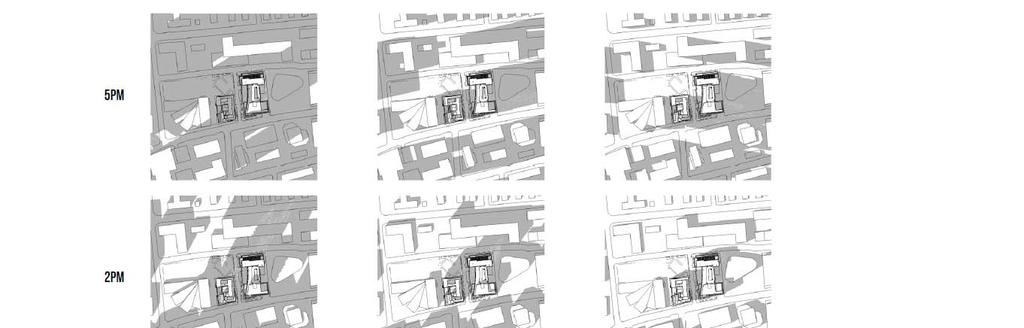
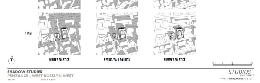
31 Page 31 Attachment B: Shadow Studies The below shadow studies were completed and presented to the County Board in June 2015 as part of the hearing item during the Request to Advertise adoption of the WRAP. They are based on the maximum height and massing considered for the WRAP concept plans.


32 Page 32 The next series of shadow studies dated October 12, 2016 was developed by the Applicant and are based on the proposed site plan buildings under consideration.
33 Page 33
34 Attachment C: Consolidated WRAP Implementation Schedule 1555 Wilson Boulevard (SP #445) Page 34
35 WRAP Implementation Page 35 Meeting Agenda 1. Welcome & Introductions (SPRC Chair) Item 2 WRAP Implementation 2. Project Coordination a) Overview WRAP Consolidated Construction Schedule i. Phasing ii. Phasing Contingencies iii. Central Emergency/Staff Contact b) Open Space Design & Construction i. Queen's Court Playground ii. Rosslyn Highlands Park c) Central emergency/staff contact Urban Design - Streetscape, circulation, and access i. 18th Street ii. N. Pierce St. iii. Pedestrian Access iv. Parking v. Loading/Drop-off/Pickup vi. Fire Station 3. Public Hearing Schedule a) Wilson School Use Permit b) Queens Court Site Plan c) 1555 Wilson Boulevard Site Plan d) Rosslyn Highlands Park Use Permit e) Fire Station 10 Use Permit f) Queens Court Playground Use Permit Site Location: The WRAP established the Western Rosslyn Coordinated Redevelopment District, an area comprised of publicly and privately owned properties generally bounded by N. Quinn Street to the west, Key Boulevard and 18 th Street to the north, 1555 Wilson Boulevard property to the East and Wilson Boulevard to the south. Applicant Information: Developer 1555 Wilson Boulevard West Rosslyn Development Company, LLC 2400 N Street, NW, #600 Washington, DC John Kusturiss (202) JKusturiss@pzre.com Developer Queens Court Residences Arlington Partnership for Affordable Housing (APAH)/Queens Court Development Corporation 2704 N. Pershing Drive Arlington, VA Carmen Romaro (703) cromero@apah.com Wilson School Arlington Public Schools, Design and Construction Services 2770 S. Taylor Street Arlington, VA Jeffrey Chambers (703) jeffrey.chambers@apsva.us
 228-3572 mrivero@arlingtonva.us Fire Station 10 Arlington County Facilities Design and Construction 1400 N. Uhle Street, Ste.")
36 WRAP Implementation Page 36 Rosslyn Highlands Park + Coordinated Open Spaces Arlington County Department of Parks and Recreation 2100 Clarendon Boulevard, Ste. 400 Arlington, VA Marco Rivero (703) mrivero@arlingtonva.us Fire Station 10 Arlington County Facilities Design and Construction 1400 N. Uhle Street, Ste. 403 Arlington, VA Michelle Cogdon (703) mcogdon@arlingtonva.us BACKGROUND: The Western Rosslyn Area Plan (WRAP) adopted by the County Board in July 2015 envisions redevelopment of the Western Area of Rosslyn with affordable housing, a new Rosslyn Highlands Park and other publicly accessible open space, high density mixed use development, development of a new Fire Station 10, and a new public secondary school. In addition to these private developments, public facilities and community amenities, other key elements to facilitate redevelopment in Western Rosslyn include the construction of a new North-South street (N. Pierce Street) and the reconstruction and regrading of 18 th Street North. Applications have simultaneously been filed with the Arlington County Zoning Office for review and approval by the County Board for each of the key development components of the WRAP. Public hearings are anticipated for each of the applications in February If approved, implementation of the WRAP as envisioned would occur through the development, permitting and construction of each of the projects beginning in 2017 and concluding in The applications under consideration as well as other proposed improvements is summarized below.
37 WRAP Implementation Page 37 Private Development Site Plans: There are two (2) site plans currently under review by the Site Plan Review Committee (SPRC) for development under the WRAP: 1555 Wilson Boulevard (SP #445) Pursuant to a Ground Lease and Development Agreement between Penzance and the County, a site plan application has been submitted for the Mixed Use Development Area of the WRAP to develop on both County owned land and Developer owned land. Consistent with the WRAP, the site plan proposes a GLUP amendment of a portion of the site from Public to High Office Apartment Hotel, and site rezoning from C-2, C-3, RA6-15 and S3-A to C-O. The proposed GLUP amendment and rezoning will permit construction of 892 residential dwelling units in two multifamily buildings and approximately 25,200 square feet of retail. The Applicant will construct the County s new Fire Station 10 within one of the two proposed residential buildings as provided in the Development Agreement. Four levels of below grade parking with access to 1,050 spaces is proposed to serve the retail and residential uses. Further, pursuant to the Development Agreement and Ground Lease, 24 parking spaces will be provided in the below grade garage for the Fire Station use and 100 parking spaces will be provided for use by Arlington Public Schools (APS). Finally, pursuant to the Development Agreement, the Applicant will construct the new Rosslyn Highlands Park on top of the below grade garage as per the County s design specifications. A future Reciprocal Easements Agreement (REA) will be established between Penzance and the County for the park, below grade garage, new street, and the APS parking spaces. Queens Court Residences (SP #444) Consistent with the WRAP, Arlington Partnership for Affordable Housing (APAH) has submitted a site plan application for the Housing Development Area of the Plan. The request includes a GLUP amendment from Low Medium Residential to High Medium Residential and rezoning the site from RA6-15 to RA4.8 to permit construction of a 12-story, 249-unit multifamily residential building. All units would be Committed Affordable (CAF) dwelling units. The Applicant further intends to apply to the County for an Arlington Housing Investment Fund (AHIF) loan in FY 2018 and the following spring (March 2018), the Virginia Housing Development Authority (VHDA) for Low Income Housing Tax Credits (LIHTC) to support the proposed project. As part of the proposal, the Applicant would dedicate approximately 9,000 square feet of site area for use as a public park pursuant to the County s Rosslyn Highland Park + Coordinated Open Spaces Plan to be designed and constructed by the County. In addition, the APAH site plan would be coordinated with the County and APS on the design and construction of 18 th Street North, the site s southern boundary on which the building fronts. Public Facilities: The following public facilities are proposed pursuant to the WRAP and require the review and approval of a use permit by the County Board: Wilson School A use permit application has been filed by Arlington Public Schools (APS) with the Arlington County Zoning Office for a new secondary school west of the residential mixed use buildings proposed by Penzance and due south of the APAH residential building. The concept and schematic designs for the new school have been the subject of extensive public review by the Arlington County School Board s Building Level Planning Committee (BLPC) and Arlington County s Public Facilities Review Committee (PFRC). The design has been incorporated into the use permit application for an estimated 775 seats and athletic field, and to
38 WRAP Implementation Page 38 accommodate the H-B Woodlawn Secondary Program, Stratford Program, ESOL/HILT and Asperger s Program currently located at the H-B Woodlawn/Stratford site on Vacation Lane. In addition, a Memorandum of Agreement (MOA) between the County and APS will provide for the cost sharing, construction and use of the athletic field and a second story terrace, as well as internal use of the building. Construction of the new school is anticipated to be completed for opening by September Fire Station 10 An approximately 18,637 square foot fire station is proposed on the ground through second floors for a portion of the eastern most multifamily residential building to be developed by Penzance. The fire station design and specifications are pursuant to the Development Agreement between Penzance and the County. The construction of the fire station will be completed by Penzance as part of its site plan for the building upon approval by the County Board. A use permit is required for a government facility in the proposed C-O zoning district of the Penzance site plan. A use permit for the new fire station will be reviewed by the County Board concurrent with the site plan. A future Fire Station Lease will be executed between Penzance and the County Board for the new fire station as well as a Reciprocal Easement Agreement. Temporary Fire Station 10 With the redevelopment of County owned land on which exists the current Fire Station 10 and Rosslyn Highlands Park, as part of the Penzance site plan, it is necessary to provide for the relocation of Fire Station 10. Further in order to provide for an accelerated construction schedule that would allow for the delivery of the new public facilities and open spaces sooner than later and reduce overall costs, the two residential buildings proposed by Penzance would be constructed in a single phase. As such, in July 2016, a License Agreement was approved between the Arlington County Board and School Board to allow a temporary fire station to be permitted on the Wilson School site for a limited period of time while the permanent new facility is under construction. At its meeting in September 2016, the County Board accepted the County Manager s recommendation to put a temporary fire station on the Wilson School site after extensive public engagement and examination of two dozen potential sites. The Temporary Fire Station is proposed to be located at the northwest corner of the Wilson School site at the intersection of 18 th Street North and N. Quinn Street. In order to mitigate impacts on the proposed construction schedule for Wilson School as a result of the siting of the temporary fire station at this location, as part of the License Agreement, the County would provide the costs for a fenced recreational field on-site, temporary covered walkways, transportation to off-site recreational facility, and incremental construction costs associated with the delayed construction of the parking garage and recreational field. The proposed use is supported by the existing site Zoning and Land Use Plan designation. The fire station would be a temporary structure comprised of two bays as well as a building for living and office space. The proposed site layout is shown below.
, APAH s Queens Court site, and APS Wilson School site.")
39 WRAP Implementation Page 39 Open Space: Adopted by the County Board in September 2016, the Rosslyn Highlands Park + Coordinated Open Spaces Plan (RHP+) depicts the general location, approximate size and overarching design features of the various park program elements located within Rosslyn Highlands Park (County/Penzance development), APAH s Queens Court site, and APS Wilson School site. Major elements include a multi-purpose court, children s playground, lighted athletic field, rooftop terrace, planted green areas and integrated seating. The park will be implemented in three phases, in partnership with the three property stakeholders: Penzance, APAH and APS. The Rosslyn Highlands Park+ Coordinated Open Spaces Plan is the master plan that is to be used to guide the design and build-out of all of the public open spaces associated with the WRAP. RHP+ was developed through a distributed and iterative planning process that broadly engaged the community. The project underwent three major phases prior to County Board review and adoption including: (1) Data Collection and Assessment, (2) Community Visioning and Concept Development, and (3) Commission Review and Concept Refinement. During this process, the communities engaged responded with various priorities including but not limited to: accommodating extensive tree canopy and open space, places for active and passive recreation, demand for a multi-purpose court facility, providing for a tot-lot and school age playground, accessibility and pedestrian safety elements, and prioritizing community drop-in use. Rosslyn Highlands Park The main Rosslyn Highlands Park site is located north of the Penzance west residential building area and will consist of approximately 22,000 sq. ft. of open space providing various passive and active recreational opportunities. Features include but are not limited to:
40 WRAP Implementation Page 40 A lighted, multi-purpose court designed for multiple activities and oriented in a direction that optimizes sunlight opportunities. Sloped green lawns surrounding the court creating critical planting space and depth for larger trees, landscaping and passive amenities, such as picnic, seating, and a play hill. Planted/permeable field boundary at the east end of the Wilson School athletic field which would provide tree canopy, while serving as a buffer for active field sports activities. Activated path (located between County/Penzance site and APS site) which will include recreational elements integrated along the pathway between the future Wilson School and the Penzance west residential building. The design development and construction of these spaces have been specified within a Development Agreement between the County and Penzance (approved by the County Board in November 2016). Per the Development Agreement, the County delivered a schematic design to the Developer in December 2016 which is currently being reviewed. The schematic design provides further design detail to the approved RHP+ concept design, and will be incorporated within the Penzance site plan. An informational open house presenting these details to the community will be planned 1 st Quarter of Furthermore, the County submitted a use permit to allow a public park use associated with the site plan project. The Parks and Recreation Commission (PRC) will review the use permit prior to County Board consideration. The use permit will be considered by the County Board concurrently with the site plan, providing opportunities for public comment. Per the Development Agreement, Penzance will construct the park, and the County will maintain it after construction.
41 WRAP Implementation Page 41 Proposed location of Rosslyn Highlands Park (north of Penzance west residential building). 1 2 Proposed location of (1) Wilson School athletic field and (2) Level Two Terrace Wilson School Site RHP+ identified two (2) outdoor spaces at the Wilson School site which will be available for community use when school is not in session. They include: (1) the rectangular, lighted athletic field and (2) the Level Two Terrace. The use permit for the Wilson School project provides more details related to the design and implementation of these spaces. Furthermore, APS and the County will enter in to, two (2) Memorandums of Agreement (MOA(s)) for: (1) Operations and Cost Sharing, and (2) Construction of these facilities. The use of indoor community facilities related to the school site will also be detailed as part of the Operations and Cost Sharing MOA. These documents will be considered by the County Board as part of the overall Wilson School use permit. Queens Court Playground Specifically pertaining to the APAH Queens Court site, the RHP+ Coordinated Open Spaces Plan envisions the construction of a playground (both for 2-5 and 5-12year old children). The approximately 9,000 square foot space will include custom play structures with design considerations including color, shape, modular ability, and safety to ensure the space relates well to the rest of the plan. Swings, see-saws, slides, and climbing structures may be integrated and should allow for year-round use. Furthermore, to deal with the possible differences in grade, a terraced seating feature is proposed, and the space is designed to be oriented at a slight northeast angle for ideal sun exposure.


42 WRAP Implementation Page 42 Proposed location of the tot-lot and school age playground on the APAH Queens Court site. Among the features provided in the RHP+ for the park space: There should be a mix of large and medium-small trees surrounding the perimeter of the playground space (mainly on the south, east, and west sides of the playground). Pedestrian circulation: clear pedestrian access should be provided to and from the main entrance of this park (located north of 18th Street North). The RHP+ shows pathways and entrances to the various RHP park spaces. Wayfinding/signs, plantings/trees, and other design elements should be incorporated to allow clear access and visibility to this space. In order to allow a public park use on the APAH Queens Court site, use permit consideration by the County Board is required which will provide opportunities for public comment (similar to Rosslyn Highlands Park at the County/Penzance site). The County will be contracting out a design firm to take the approved RHP+ concept design to a schematic design and ultimately a detailed design for design development and construction. Unlike the Rosslyn Highlands Park use permit at the County/Penzance site, the public park use permit associated with the APAH Queens Court site will be filed and considered by the County Board after site plan consideration. After APAH reconstructs the Queens Court site, the County will construct and maintain the park improvements. The details of this arrangement will be captured in a separate MOA to be considered by the County Board.
ARLINGTON COUNTY, VIRGINIA
 ARLINGTON COUNTY, VIRGINIA County Board Agenda Item Meeting of April 23, 2019 DATE: April 12, 2019 SUBJECT: SP #413 SITE PLAN AMENDMENT to permit a fixed bar in a private outdoor café space with associated
SITE PLAN REVIEW COMMITTEE MEETING AGENDA Clarendon Boulevard Conference Room 311 Arlington, VA 22201
 SITE PLAN REVIEW COMMITTEE MEETING AGENDA DATE: Thursday, July 13, 2017 TIME: 7:00 8:30 p.m. PLACE: 2100 Clarendon Boulevard Conference Room 311 Arlington, VA 22201 SPRC STAFF COORDINATOR: TBD Item 1.
TO: FROM: SUBJECT: Background
 TO: FROM: SUBJECT: Long Range Planning Committee and Zoning Committee of the Planning Commission Kellie Brown and Margaret Rhodes, Planning Division, CPHD DATE: June 8, 2017 Courthouse Square Implementation
SITE PLAN REVIEW COMMITTEE MEETING AGENDA. Courthouse Plaza 2100 Clarendon Boulevard Cherry and Dogwood Rooms (C&D) Arlington, VA 22201
 Arlington, VA 22201") Page 1 SITE PLAN REVIEW COMMITTEE MEETING AGENDA DATE: Monday, May 15, 2017 TIME: 8:00 10:00 p.m. PLACE: Courthouse Plaza 2100 Clarendon Boulevard Cherry and Dogwood Rooms (C&D) Arlington, VA 22201 SPRC
Page 1 SITE PLAN REVIEW COMMITTEE MEETING AGENDA DATE: Monday, May 15, 2017 TIME: 8:00 10:00 p.m. PLACE: Courthouse Plaza 2100 Clarendon Boulevard Cherry and Dogwood Rooms (C&D) Arlington, VA 22201 SPRC
ARLINGTON COUNTY, VIRGINIA
 ARLINGTON COUNTY, VIRGINIA County Board Agenda Item Meeting of September 19, 2015 DATE: September 11, 2015 SUBJECTS: Outdoor Café at Citizen Burger Bar A. SP# 418 Site Plan Amendment to modify an approved
ARLINGTON COUNTY, VIRGINIA
 ARLINGTON COUNTY, VIRGINIA County Board Agenda Item Meeting of March 10, 2012 DATE: February 29, 2012 SUBJECT: SP #197 SITE PLAN AMENDMENT to add a new condition #25 to allow a new use for a Yoga and Pilates
ARLINGTON COUNTY, VIRGINIA
 ARLINGTON COUNTY, VIRGINIA County Board Agenda Item Meeting October 15, 2005 DATE: September 28, 2005 SUBJECT: Request to Advertise the adoption of the 2005 Clarendon Sector Plan C. M. RECOMMENDATION:
ARLINGTON COUNTY, VIRGINIA
 ARLINGTON COUNTY, VIRGINIA County Board Agenda Item Meeting of October 23, 2004 DATE: October 6, 2004 SUBJECT: SP #106-3 Site Plan Amendment for changes to façade, plaza deck, landscaping, number of units,
ARLINGTON COUNTY, VIRGINIA
 ARLINGTON COUNTY, VIRGINIA County Board Agenda Item Meeting of July 21, 2012 DATE: July 12, 2012 SUBJECT: SP #416 SITE PLAN AMENDMENT to modify condition #6 to eliminate requirement to provide a pedestrian
ARLINGTON COUNTY, VIRGINIA. County Board Agenda Item Meeting of February 23, 2019
 ARLINGTON COUNTY, VIRGINIA County Board Agenda Item Meeting of February 23, 2019 DATE: February 15, 2019 SUBJECT: Amendment to the Master Transportation Plan (MTP) Map to add a new section of North Kansas
SP #94, AREP Rosslyn City Center
 SP #94, AREP Rosslyn City Center 1700 & 1810 N. Moore Street Department of Community Planning, Housing, and Development County Board July 15, 2017 1 19 th Street N. Wilson Boulevard Location Rosslyn City
ARLINGTON COUNTY, VIRGINIA. County Board Agenda Item Meeting of June 16, 2018
 ARLINGTON COUNTY, VIRGINIA County Board Agenda Item Meeting of June 16, 2018 DATE: June 7, 2018 SUBJECT: Z-2604-18-1 Rezoning from R-6 and R-5 Single Family Residential Districts to S-3A Special District
S I T E P L A N R E V I E W C O M M I T T E E M E E T I N G A G E N D A Clarendon Boulevard Conference Room 311 Arlington, VA 22201
 S I T E P L A N R E V I E W C O M M I T T E E M E E T I N G A G E N D A DATE: Monday, October 2, 2017 TIME: 7:00 8:25 p.m. PLACE: 2100 Clarendon Boulevard Conference Room 311 Arlington, VA 22201 SPRC STAFF
PLANNING IN ARLINGTON. Briefing to Katie Cristol
 1 PLANNING IN ARLINGTON Briefing to Katie Cristol Overview 2 Comprehensive Plan - Background Administration of the Comprehensive Plan Review of the Comprehensive Plan Implementation of the Comprehensive
S I T E P L A N R E V I E W C O M M I T T E E M E E T I N G A G E N D A
 S I T E P L A N R E V I E W C O M M I T T E E M E E T I N G A G E N D A DATE: Monday, March 11, 2019 TIME: 7:00 8:25 p.m. PLACE: 2100 Clarendon Boulevard Lobby Rooms C&D (Cherry & Dogwood) Arlington, VA
(DC1) Direct Development Control Provision DC1 Area 4
 Direct Development Control Provision DC1 Area 4") . General Purpose (DC) Direct Development Control Provision DC Area 4 The purpose of this Provision is to provide for an area of commercial office employment and residential development in support of the
. General Purpose (DC) Direct Development Control Provision DC Area 4 The purpose of this Provision is to provide for an area of commercial office employment and residential development in support of the
SITE PLAN REVIEW COMMITTEE MEETING AGENDA
 Page 1 SITE PLAN REVIEW COMMITTEE MEETING AGENDA DATE: Tuesday, November 13, 2018 TIME: 7:00-8:30 p.m. PLACE: Bozman Government Center, 2100 Clarendon Blvd., Room 311 Arlington, VA 22201 SPRC STAFF COORDINATOR:
SITE PLAN REVIEW COMMITTEE MEETING AGENDA. Matt Ladd
 SITE PLAN REVIEW COMMITTEE MEETING AGENDA DATE: Thursday, April 26, 2018 TIME: 7:00 8:30 p.m. PLACE: Ellen Bozman Government Center/Courthouse Plaza 2100 Clarendon Boulevard Lobby Rooms C&D (Cherry and
Courthouse Square Implementation Comment/Response Matrix
 Courthouse Square Implementation /Response Matrix 1 Are open space symbols binding? GLUP No, open space symbols are not binding, as the GLUP is a policy instrument illustrating the County s future vision
ARLINGTON COUNTY, VIRGINIA. County Board Agenda Item Meeting of February 25, 2017
 ARLINGTON COUNTY, VIRGINIA County Board Agenda Item Meeting of February 25, 2017 DATE: February 17, 2017 SUBJECT: U-3468-16-1 USE PERMIT for an approximately 180,000 square foot new school () occupied
Bloor St. W. Rezoning - Preliminary Report
 STAFF REPORT ACTION REQUIRED 1638-1644 Bloor St. W. Rezoning - Preliminary Report Date: April 1, 2008 To: From: Wards: Reference Number: Toronto and East York Community Council Acting Director, Community
ATTACHMENT. To the west, north, and east of the block, primarily singlefamily detached residential patterns, with some townhouses, predominate.
 COMMENT / REVISION MATRIX (as of ) for Washington and Kirkwood Special GLUP Study "Plus" and Concept Plan 1 2 Resolve inconsistency between American Legion site area noted in Map 1 1.36 AC 1.29 AC and
SITE PLAN REVIEW COMMITTEE MEETING AGENDA
 Page 1 SITE PLAN REVIEW COMMITTEE MEETING AGENDA DATE: Monday, January 7, 2019 TIME: 7:00-8:30 p.m. PLACE: Washington-Lee High School Commons, 1301 North Stafford Street Arlington, VA 22201 SPRC STAFF
ARLINGTON COUNTY, VIRGINIA
 ARLINGTON COUNTY, VIRGINIA County Board Agenda Item Meeting of October 17, 2015 DATE: October 6, 2015 SUBJECT: SP #1 SITE PLAN AMENDMENT REVIEW to modify Zoning Ordinance sign requirements and facade modifications
Rosslyn Sector Plan Implementation
 DEPARTMENT OF COMMUNITY PLANNING, HOUSING AND DEVELOPMENT Planning Division #1 Courthouse Plaza, 2100 Clarendon Boulevard, Suite 700 Arlington, VA 22201 TEL 703.228.3525 FAX 703.228.3543 www.arlingtonva.us
CRYSTAL CITY BLOCK PLAN # CCBP- G 1 DRAFT
 CRYSTAL CITY BLOCK PLAN # CCBP- G 1 DRAFT BLOCK G (Metro Market Square block) Long Range Planning Committee Meeting January 29, 2018 1 1. Introduction 2 1. LRPC Meeting Purpose Review of proposed Crystal
S I T E P L A N R E V I E W C O M M I T T E E M E E T I N G A G E N D A
 S I T E P L A N R E V I E W C O M M I T T E E M E E T I N G A G E N D A DATE: Monday, October 30, 2017 TIME: 7:00 8:30 p.m. PLACE: 2100 Clarendon Boulevard Lobby Rooms C&D (Cherry & Dogwood) Arlington,
Public Workshop. November 8, 2014 Key Elementary School
 Public Workshop November 8, 2014 Key Elementary School Agenda: I. Opening Remarks II. Overview of Study III. Review of Concept Plans IV. Q&A V. Break VI. Table Exercises VII. Wrap Up VIII. Adjournment
ARLINGTON COUNTY, VIRGINIA
 ARLINGTON COUNTY, VIRGINIA County Board Agenda Item Meeting of December 16, 2017 DATE: December 7, 2017 SUBJECT: SP#105-8 SITE PLAN AMENDMENT to remove a retail kiosk and add outdoor café seating in ;
Appendix I ARLINGTON COUNTY SECTOR PLANS SUMMARY RECOMMENDATIONS RELATED TO PUBLIC SPACES
 Appendix I ARLINGTON COUNTY SECTOR PLANS SUMMARY RECOMMENDATIONS RELATED TO PUBLIC SPACES The County has developed Sector Plans for various planning areas within Arlington County s Metro corridors. Following
599 Kennedy Road - Official Plan Amendment and Zoning Amendment Application - Preliminary Report
 STAFF REPORT ACTION REQUIRED 599 Kennedy Road - Official Plan Amendment and Zoning Amendment Application - Preliminary Report Date: March 7, 2017 To: From: Wards: Reference Number: Scarborough Community
ARLINGTON COUNTY PLANNING COMMISSION SITE PLAN REVIEW COMMITTEE SITE PLAN CHAIR GUIDE
 ARLINGTON COUNTY PLANNING COMMISSION SITE PLAN REVIEW COMMITTEE SITE PLAN CHAIR GUIDE Excerpts from the SPRC Operating Guide, 1/31/04 Revised March 17,2010 1. Site Plan Chair Responsibilities 1 1, The
SITE PLAN REVIEW COMMITTEE MEETING AGENDA. Matt Ladd
 SITE PLAN REVIEW COMMITTEE MEETING AGENDA DATE: Thursday, April 26, 2018 TIME: 7:00 8:30 p.m. PLACE: Ellen Bozman Government Center/Courthouse Plaza 2100 Clarendon Boulevard Lobby Rooms C&D (Cherry and
SPRC PRESENTATION #3 JUNE 22, 2015
 TABLE OF CONTENTS: PROJECT REVIEW: 1. PHASE DIAGRAM 2. SITE PLAN; PHASE ONE + TWO 3. CONCEPTUAL 4040 MASSING 4. ACCESS EASEMENT; PHASE 2 CONSTRUCTION 5. ACCESS EASTMENT; FUTURE DEVELOPMENT RESPONSES TO
ARLINGTON COUNTY, VIRGINIA. County Board Agenda Item Meeting of June 13, 2015
 ARLINGTON COUNTY, VIRGINIA County Board Agenda Item Meeting of June 13, 2015 DATE: June 10, 2015 SUBJECT: Request to Authorize Advertisement of Public Hearings by the Planning Commission and the County
MONTGOMERY COUNTY PLANNING DEPARTMENT
 MONTGOMERY COUNTY PLANNING DEPARTMENT THE MARYLAND-NATIONAL CAPITAL PARK AND PLANNING COMMISSION MCPB Item No.: Date: 5-03-18 Pike and Rose, Phase I: Site Plan Amendment No. 82012002D Rhoda Hersson-Ringskog,
13 THORNHILL YONGE STREET STUDY IMPLEMENTATION CITY OF VAUGHAN OPA 669 AND TOWN OF MARKHAM OPA 154
 13 THORNHILL YONGE STREET STUDY IMPLEMENTATION CITY OF VAUGHAN OPA 669 AND TOWN OF MARKHAM OPA 154 The Planning and Economic Development Committee recommends the adoption of the recommendations contained
Clairtrell Area Context Plan
 Clairtrell Area Context Plan March 2005 Urban Development Services City Planning Contents 1. Introduction... 4 2. Development Structure... 6 2.1 Streets... 7 2.1.1 Sheppard Avenue and Bayview Avenue...
DEPARTMENT OF COMMUNITY PLANNING, HOUSING AND DEVELOPMENT Planning Division. Arlington County Planning Commission
 DEPARTMENT OF COMMUNITY PLANNING, HOUSING AND DEVELOPMENT Planning Division 2100 Clarendon Boulevard, Suite 700 Arlington, VA 22201 TEL 703.228.3525 FAX 703.228.3543 www.arlingtonva.us DRAFT TO: FROM:
SPRC PRESENTATION MAY 13, 2015
 TABLE OF CONTENTS: 1. EXISTING SITE CONTEXT MAP 2. PHASING DIAGRAM 3. SITE PLAN (PHASE ONE) 4. SITE PLAN (PHASE ONE + CONCEPTUAL PHASE TWO) 5. TRAFFIC MAP 6. SITE PLAN ACCESSIBILITY (PHASE ONE) 7. STREET
SITE PLAN AREA. Met Park 6 Site Area (122,368 sf) Met Park 4/5 The Bartlett. Met Park 3 The Acadia. Met Park 2 The Millennium.
 Met Park 4/5 The Bartlett. Met Park 3 The Acadia. Met Park 2 The Millennium.") SITE PLAN AREA Met Park 4/5 The Bartlett Met Park 3 The Acadia Met Park 2 The Millennium Met Park 6 Site Area (122,368 sf) Met Park 1 The Gramercy Met Park 7 and 8 2 SUBJECT SITE Existing Use: Pentagon
SITE PLAN AREA Met Park 4/5 The Bartlett Met Park 3 The Acadia Met Park 2 The Millennium Met Park 6 Site Area (122,368 sf) Met Park 1 The Gramercy Met Park 7 and 8 2 SUBJECT SITE Existing Use: Pentagon
Residential Commons at Barry s Corner. Boston civic design commission February 5, 2013
 Residential Commons at Barry s Corner Boston civic design commission February 5, 2013 TABLE OF CONTENTS project summary 3 PROJECT site 4 PLANNING APPROACh 6 Parcel Diagams 6 Design Principles 8 Street
S I T E P L A N R E V I E W C O M M I T T E E M E E T I N G A G E N D A & S T A F F R E P O R T
 S I T E P L A N R E V I E W C O M M I T T E E M E E T I N G A G E N D A & S T A F F R E P O R T DATE: Thursday, January 21, 2016 TIME: 7:00 10:00 p.m. PLACE: Courthouse Plaza; Cherry/Dogwood Conference
2.7 ac park. TOTAL 5,403 DU 1,297,900 sf 1,105,450 sf 3.87 ac 5,563 DU 1,121,200 sf 1,105,450 sf 3.87 ac
 PLAN AMENDMENT 2013-I-B1: SEVEN CORNERS SPECIAL STUDY Summary of Pre-staffing Comments Planner: Bernard Suchicital bsuchi@fairfaxcounty.gov (703) 324-1254 Background On October 29, 2013, the Board of Supervisors
ARLINGTON COUNTY, VIRGINIA
 ARLINGTON COUNTY, VIRGINIA County Board Agenda Item Meeting of April 12, 2014 DATE: April 2, 2014 SUBJECT: to the Arlington County Zoning Ordinance, Article 11.1 "CP-FBC" Columbia Pike Form Based Code
WEST LOOP DESIGN GUIDELINES CHECKLIST
 WEST LOOP DESIGN GUIDELINES CHECKLIST Section 1.0 General Strategies 1.1 DESIGN EXCELLENCE: ENCOURAGE HIGH QUALITY AND INNOVATIVE DESIGN OF NEW BUILDINGS WITHIN THE WEST LOOP WITHOUT BEING PRESCRIPTIVE
Gold Line Bus Rapid Transit Transit Oriented Development (BRTOD) Helmo Station Area Plan
 Helmo Station Area Plan") Appendix F Gold Line Bus Rapid Transit Transit Oriented Development (BRTOD) Helmo Station Area Plan Introduction and Purpose of the Plan The Gold Line Bus Rapid Transit facility is an eleven-mile dedicated
Appendix F Gold Line Bus Rapid Transit Transit Oriented Development (BRTOD) Helmo Station Area Plan Introduction and Purpose of the Plan The Gold Line Bus Rapid Transit facility is an eleven-mile dedicated
SITE PLAN REVIEW COMMITTEE MEETING AGENDA Crystal Drive, 11 th Floor Arlington, VA 22202
 Page 1 SITE PLAN REVIEW COMMITTEE MEETING AGENDA DATE: Thursday, October 26, 2017 TIME: 7:00 9:00 p.m. PLACE: 2011 Crystal Drive, 11 th Floor Arlington, VA 22202 SPRC STAFF COORDINATOR: Matt Ladd, 703-228-3525
SITE PLAN REVIEW COMMITTEE MEETING AGENDA
 SITE PLAN REVIEW COMMITTEE MEETING AGENDA DATE: Monday June 8, 2015 TIME: 7:00 10 p.m. PLACE: 2100 Clarendon Boulevard Courthouse Plaza, 1st Floor, Cherry and Dogwood Rooms Arlington, VA 22202 SPRC STAFF
From: Sent: To: Subject: Zoning: Landscaping:
 From: Bernard H. Berne [mailto:bhberne@yahoo.com] Sent: Tuesday, May 15, 2012 1:18 AM To: CountyBoard Subject: May 19, 2012 County Board Meeting: Goodyear Site Plan (SP #72-650 N. Glebe Road) and amendment
S I T E P L A N R E V I E W C O M M I T T E E M E E T I N G A G E N D A
 S I T E P L A N R E V I E W C O M M I T T E E M E E T I N G A G E N D A DATE: Monday, July 23, 2018 TIME: 7:00 9:00 p.m. PLACE: Ellen M. Bozman Government Center Conference Rooms C/D (Lobby Level) 2100
SITE PLAN REVIEW COMMITTEE MEETING AGENDA. NRECA Conference Center 4301 Wilson Blvd. Arlington, VA 22201
 SITE PLAN REVIEW COMMITTEE MEETING AGENDA DATE: Monday, May 14, 2018 TIME: 7:00 10:00 p.m. PLACE: NRECA Conference Center 4301 Wilson Blvd. SPRC STAFF LIAISON: Matthew Ladd, 703-228-3525 Item 1. Virginia
40 Years of Smart Growth Arlington County s Experience with Transit Oriented Development in the Rosslyn-Ballston Metro Corridor
 40 Years of Smart Growth Arlington County s Experience with Transit Oriented Development in the Rosslyn-Ballston Metro Corridor A presentation by the Arlington County Department of Community Planning,
ARLINGTON COUNTY, VIRGINIA
 ARLINGTON COUNTY, VIRGINIA County Board Agenda Item Meeting of March 20, 2007 SUPPLEMENTAL REPORT #2 Additional and Revised Information DATE: March 20, 2007 SUBJECT: Request to Advertise Public Hearings
Policies and Code Intent Sections Related to Town Center
 Policies and Code Intent Sections Related to Town Center The Town Center Vision is scattered throughout the Comprehensive Plan, development code and the 1994 Town Center Plan. What follows are sections
523, 525 and 525A Adelaide Street West - Zoning Amendment Application - Preliminary Report
 STAFF REPORT ACTION REQUIRED 523, 525 and 525A Adelaide Street West - Zoning Amendment Application - Preliminary Report Date: May 12, 2012 To: From: Wards: Reference Number: Toronto and East York Community
SITE PLAN REVIEW COMMITTEE MEETING SUMMARY
 DEPARTMENT OF COMMUNITY PLANNING, HOUSING AND DEVELOPMENT Planning Division/Site Plan Review Committee 2100 Clarendon Boulevard, Suite 700, Arlington, VA 22201 TEL 703-228-3525 FAX 703-228-3543 www.arlingtonva.us
Regency Developments. Urban Design Brief. Holyrood DC2 Rezoning
 Regency Developments Urban Design Brief Holyrood DC2 Rezoning Stantec Consulting Ltd. 7-31-2017 1. Overview Regency Developments intends to rezone the lands located at 8510 and 8511 93 Avenue, within the
Courthouse Square Planning & Urban Design Study. Courthouse Square Working Group #13 October 15, 2014
 Courthouse Square Planning & Urban Design Study Courthouse Square Working Group #13 October 15, 2014 1 Courthouse Square Process Working Group Community Courthouse Square Advisory Groups & Civic Associations
Arlington County Long Range Planning Committee Meeting
 Arlington County Long Range Planning Committee Meeting Preliminary FY2015 Planning Division Work Program A presentation by the Arlington County Department of Community Planning, Housing and Development,
Review of Opportunity Area C Draft Comprehensive Plan and Draft BOS Follow-On Motions. Special Working Group Meeting March 4, 2015
 Review of Opportunity Area C Draft Comprehensive Plan and Draft BOS Follow-On Motions Special Working Group Meeting March 4, 2015 The slides that follow identify where the draft Comprehensive Plan has
July 23, 2014 Wilson School. Working Group Meeting #3 Preliminary Site Analysis School Siting Considerations Guiding Principles
 July 23, 2014 Wilson School Working Group Meeting #3 Preliminary Site Analysis School Siting Considerations Guiding Principles Agenda Follow-Up from Meeting #2: WG & community feedback Presentations /
REQUEST Current Zoning: O-15(CD) (office) Proposed Zoning: TOD-M(CD) (transit oriented development mixed-use, conditional)
 (office) Proposed Zoning: TOD-M(CD) (transit oriented development mixed-use, conditional)") Rezoning Petition 2016-117 Zoning Committee Recommendation January 4, 2017 REQUEST Current Zoning: O-15(CD) (office) Proposed Zoning: TOD-M(CD) (transit oriented development mixed-use, conditional) LOCATION
Rezoning Petition 2016-117 Zoning Committee Recommendation January 4, 2017 REQUEST Current Zoning: O-15(CD) (office) Proposed Zoning: TOD-M(CD) (transit oriented development mixed-use, conditional) LOCATION
Pentagon Centre (SP#297) Phase I Site Plan Amendments SPRC #3
 Phase I Site Plan Amendments SPRC #3") Pentagon Centre (SP#297) Phase I Site Plan Amendments SPRC #3 CPHD April 23, 2015 Meeting Agenda Overview of approved Phase I Site Plan Review of relevant design guidelines Presentation of current proposal
Pentagon Centre (SP#297) Phase I Site Plan Amendments SPRC #3 CPHD April 23, 2015 Meeting Agenda Overview of approved Phase I Site Plan Review of relevant design guidelines Presentation of current proposal
WRAPS Site Studies. Cooper, Robertson & Partners. December 8, Page 1
 WRAPS Page 1 Realigned N. Pierce Street & Extension Base 1 FOR PRESENTATION TOTAL GSF OFFICE 346,000 RESIDENTIAL 795,000 POTENTIAL RETAIL 40,000 TOTAL 1,181,000 795 DU Open Space (Development Parcels)
ARLINGTON COUNTY, VIRGINIA
 ARLINGTON COUNTY, VIRGINIA County Board Agenda Item Meeting of May 10, 2014 DATE: May 1, 2014 SUBJECT: SP #105 SITE PLAN AMENDMENT to modify several site plan conditions for Phase 3 of the Metropolitan
WHEREAS, after consideration of the evidence presented at the public hearing on January 14, 2010, the Prince George's County Planning Board finds:
 R E S O L U T I O N WHEREAS, the Prince George s County Planning Board has reviewed DDS-600 requesting a departure for the location of two loading spaces without driveway access along Toledo Terrace in
Staff Report to the North Ogden City Planning Commission
 Staff Report to the North Ogden City Planning Commission SYNOPSIS / APPLICATION INFORMATION Application Request: Concept review on a legislative application to rezone land located at approximately 1750
MIDTOWN MIXED-USE VILLAGE. TECHNICAL DATA SHEET COMPONENT C-1 FOR PUBLIC HEARING - PETITION NUMBER Project No RZ1.1. Issued.
 N MIDTOWN MIXED-USE VILLAGE TECHNICAL DATA SHEET COMPONENT C- FOR PUBLIC HEARING - PETITION NUMBER 04-00 Project No. 496 Issued Revised SCALE: " = 0' N 0 0 0 40 RZ. c GENERAL PROVISIONS: a. SITE LOCATION.
646 Kingston Road - Official Plan Amendment and Zoning Amendment Applications - Preliminary Report
 STAFF REPORT ACTION REQUIRED 646 Kingston Road - Official Plan Amendment and Zoning Amendment Applications - Preliminary Report Date: December 8, 2014 To: From: Wards: Reference Number: Toronto and East
A. INTRODUCTION B. PROJECT LOCATION
 Chapter 1: Project Description A. INTRODUCTION The Lower Manhattan Development Corporation (LMDC), a subsidiary of the New York State Urban Development Corporation, doing business as the Empire State Development
4.1.3 LAND USE CATEGORIES
 4.1.3 LAND USE CATEGORIES a. City Center District The City Center District incorporates the existing character and mix of uses in downtown Belmont to encourage redevelopment and new development in keeping
40 Years of Smart Growth Arlington County s Experience with Transit Oriented Development in the Rosslyn-Ballston Metro Corridor
 40 Years of Smart Growth Arlington County s Experience with Transit Oriented Development in the Rosslyn-Ballston Metro Corridor A presentation by the Arlington County Department of Community Planning,
30 and 44 Zorra Street - Zoning By-law Amendment Application - Preliminary Report
 STAFF REPORT ACTION REQUIRED 30 and 44 Zorra Street - Zoning By-law Amendment Application - Preliminary Report Date: March 14, 2016 To: From: Wards: Reference Number: Etobicoke York Community Council Director,
Queen Street West - Zoning Amendment Application - Preliminary Report
 STAFF REPORT ACTION REQUIRED 944-952 Queen Street West - Zoning Amendment Application - Preliminary Report Date: February 6, 2013 To: From: Wards: Reference Number: Toronto and East York Community Council
ELMVALE ACRES SHOPPING CENTRE MASTER PLAN
 ELMVALE ACRES SHOPPING CENTRE MASTER PLAN Contents 1.0 INTRODUCTION... 2 2.0 LOCATION... 2 3.0 EXISTING CONTEXT... 2 4.0 VISION & GUIDING PRINCIPLES... 2 5.0 LAND USE AND BUILT FORM... 4 5.1 St. Laurent
Highland Village Green Design Guidelines
 Highland Village Green Design Guidelines Publishing Information Title Highland Village Green Design Guidelins Author The City of Calgary Status DRAFT - Proposed document subject to changes Additional Copies
Chapter PEDESTRIAN COMMERCIAL (PC) ZONING DISTRICT
 ZONING DISTRICT") Chapter 11-17 PEDESTRIAN COMMERCIAL (PC) ZONING DISTRICT Sections: 11-17-01 GENERAL PURPOSE 11-17-02 PERMITTED BUILDING TYPES 11-17-03 USES PERMITTED WITH DESIGN REVIEW 11-17-04 USES PERMITTED BY CONDITIONAL
Chapter 11-17 PEDESTRIAN COMMERCIAL (PC) ZONING DISTRICT Sections: 11-17-01 GENERAL PURPOSE 11-17-02 PERMITTED BUILDING TYPES 11-17-03 USES PERMITTED WITH DESIGN REVIEW 11-17-04 USES PERMITTED BY CONDITIONAL
Yonge Eglinton Centre Urban Design Guidelines
 Yonge Eglinton Centre Urban Design Guidelines City Planning Urban Design January 2009 YONGE EGLINTON CENTRE INTRODUCTION.................................................... 1 GENERAL SITE PLAN OBJECTIVES......................................
The Village of Shirlington
 The Village of Shirlington Suburban Smart Growth Without Rail Transit July 2018 Agenda History (1940 to present) Attributes and Outcomes Lessons Learned Setting the Stage Arlington County Arlington is
CRYSTAL CITY BLOCK PLAN # CCBP- G 1
 CRYSTAL CITY BLOCK PLAN # CCBP- G 1 BLOCK G (Metro Market Square block) Long Range Planning Committee Meeting #3 April 2, 2018 1 1. Tonight s Agenda 1. Introductory Remarks (Jane Siegel) 2. Follow-up from
S I T E P L A N R E V I E W C O M M I T T E E M E E T I N G A G E N D A. The Bartlett th Street South Arlington, Virginia 22202
 S I T E P L A N R E V I E W C O M M I T T E E M E E T I N G A G E N D A DATE: Thursday, May 24, 2018 TIME: 7:00 8:30 p.m. PLACE: The Bartlett 520 12th Street South Arlington, Virginia 22202 SPRC STAFF
1296 Kennedy Road - Zoning Amendment Application - Preliminary Report
 STAFF REPORT ACTION REQUIRED 1296 Kennedy Road - Zoning Amendment Application - Preliminary Report Date: January 15, 2016 To: From: Wards: Reference Number: Scarborough Community Council Acting Director,
PINE CURVE REZONING. Property does not meet criteria for open space preservation and is not a candidate for a park
 PINE CURVE REZONING BACKGROUND Purchased as two parcels in 2001 and 2002 Annexed and Zoned Greater Downtown District Historic Center September 25, 2002 and October 7, 2002 WHAT THE PROJECT IS AND IS NOT
ARLINGTON COUNTY, VIRGINIA. County Board Agenda Item Meeting of January 28, 2017 SUPPLEMENTAL REPORT-2
 ARLINGTON COUNTY, VIRGINIA County Board Agenda Item Meeting of January 28, 2017 SUPPLEMENTAL REPORT-2 DATE: January 27, 2017 SUBJECT: The Virginia Department of Transportation s Transform I-66 Inside the
S I T E P L A N R E V I E W C O M M I T T E E M E E T I N G A G E N D A. Aurora Hills Community Center 735 S. 18 th Street Arlington, VA 22202
 S I T E P L A N R E V I E W C O M M I T T E E M E E T I N G A G E N D A DATE: Monday, March 16, 2015 TIME: 7:00 9:00 p.m. PLACE: Aurora Hills Community Center 735 S. 18 th Street Arlington, VA 22202 SPRC
1071 King Street West Zoning Amendment Application - Preliminary Report
 STAFF REPORT ACTION REQUIRED 1071 King Street West Zoning Amendment Application - Preliminary Report Date: August 9, 2012 To: From: Wards: Reference Number: Toronto and East York Community Council Director,
DRAFT. October Wheaton. Design Guidelines
 October 2011 DRAFT Wheaton Design Guidelines 2 Draft - Design Guidelines - Wheaton Sector Plan Contents 04 Section 1: Introduction 06 Section 2: Context 08 Section 3: Design Guidelines 09 Goal 1: Create
SITE PLAN REVIEW COMMITTEE MEETING AGENDA & STAFF REPORT. DATE: Monday, October 12, :00 10:00 p.m. PLACE:
 SITE PLAN REVIEW COMMITTEE MEETING AGENDA & STAFF REPORT DATE: Monday, October 12, 2015 TIME: 7:00 10:00 p.m. PLACE: NRECA 4301 Wilson Boulevard Room CC1 Arlington, VA 22203 SPRC STAFF COORDINATOR: Samia
3.0 URBAN DESIGN. December 6, OVERVIEW
 Urban Design 3.0 URBAN DESIGN December 6, 2007 3.1 OVERVIEW The highly urban character of Easton Place is defined by the overall design of the community. The following sections provide an overview of the
- INVITATION - COURTESY INFORMATIONAL MEETING
 - INVITATION - COURTESY INFORMATIONAL MEETING Hosted by the Property Owner and Project Developer CAMELLIA COURT DEVELOPMENT WEDNESDAY, JANUARY 25, 2017, 7:00 9:00 P.M. BLOY CENTER 1441 S. BENITO AVE, ALHAMBRA,
DEPARTMENT OF COMMUNITY PLANNING, HOUSING AND DEVELOPMENT Planning Division/Site Plan Review Committee
 DEPARTMENT OF COMMUNITY PLANNING, HOUSING AND DEVELOPMENT Planning Division/Site Plan Review Committee 2100 Clarendon Boulevard, Suite 700, Arlington, VA 22201 TELL 703-228-3525 FAX 703-228-3543 www.arlingtonva.us
CITY OF MERCER ISLAND DESIGN COMMISSION STAFF REPORT
 CITY OF MERCER ISLAND DESIGN COMMISSION STAFF REPORT Agenda Item: 2 March 9, 2011 Project: Description: Applicant: DSR11-004 The applicant is requesting approval to replace the existing exterior wood framed
ROSSLYN GATEWAY URBAN DESIGN MANUAL JULY 15, 2011 REVISED JANUARY 30, KOHN PEDERSEN FOX ASSOCIATES PC. All rights reserved.
 ROSSLYN GATEWAY URBAN DESIGN MANUAL JULY 15, 2011 REVISED JANUARY 30, 2012 OVERVIEW Rosslyn Gateway is mixed-use development located at the Virginia landing of the Francis Scott Key Bridge in Rosslyn,
SITE PLAN REVIEW COMMITTEE MEETING AGENDA Clarendon Boulevard Conference Rooms C & D Arlington, VA 22201
 SITE PLAN REVIEW COMMITTEE MEETING AGENDA DATE: Thursday, February 2, 2017 TIME: 7:30 10:00 p.m. PLACE: 2100 Clarendon Boulevard Conference Rooms C & D Arlington, VA 22201 SPRC STAFF COORDINATOR: Samia
The subject site plan amendment proposes the following revisions to the approved site plan:
 PROPOSED AMENDMENT The subject site plan amendment proposes the following revisions to the approved site plan: 1. The building footprint was modified to accommodate the revised architectural design. 2.
ARTICLE 6: Special and Planned Development Districts
 ARTICLE 6: Special and Planned Development Districts 6-10 Traditional Neighborhood Development (TND) District 6-10.10 Purpose and Intent The Traditional Neighborhood Development (TND) District provides
HIGHLAND VILLAGE GREEN URBAN DESIGN PRINCIPLES/GUIDELINES
 URBAN DESIGN GUIDING PRINCIPLES/GUIDELINES CONTEXT/CHARACTER The City of Calgary s Municipal Development Plan (MDP), Transit-Oriented Development (TOD) Policy Guidelines and Main Street/Corridor policy
2900 Steeles Avenue East at Don Mills Road in the Town of Markham
 STAFF REPORT INFORMATION ONLY 2900 Steeles Avenue East at Don Mills Road in the Town of Markham Date: January 23, 2008 To: From: Wards: Reference Number: North York Community Council Director, Community
PINE CURVE REZONING. BACKGROUND Purchased as two parcels in 2001 and 2002
 BACKGROUND Purchased as two parcels in 2001 and 2002 WHAT THE PROJECT IS AND IS NOT A Rezoning establishes the land use standards for Annexed and Zoned Greater Downtown District Historic Center September