Southwest Ecodistrict CREATING A MORE SUSTAINABLE FUTURE ULI/GSA Symposium: Planning the Future of Federal Triangle South March 27 th, 2013
|
|
|
- Amice Heath
- 5 years ago
- Views:
Transcription

1 Southwest Ecodistrict CREATING A MORE SUSTAINABLE FUTURE ULI/GSA Symposium: Planning the Future of Federal Triangle South March 27 th, 2013


2 Study Area The National Mall DOE FAA FAA Cotton Annex DOE DOE NPS Education GSA USPS HUD SW Freeway NPS 2

3 Overview 3

4 Momentum GSA Federal Triangle South Request for Information ` Central Utility Plant Operations Study City Maryland Avenue Transportation Study Long Bridge Capacity Study Private Property Owners The Wharf L Enfant Plaza Business Improvement District 4

5 Goals Transform the 10th Street and Maryland Avenue corridors into a highly sustainable, well-connected mixed-use community. Create an environmental showcase of high performance buildings and landscapes. 5

6 How to Achieve a Highly Sustainable Mixed-use Community 6


7 The Neighborhood Development Framework Land Use Mix Active Street Frontage Independence Ave 10 th St 7 th St 4 th St Independence Ave 10 th St 7 th St 4 th St Federal + Cultural Mixed Use I-395 Civic Retail Node Retail Frontage Active Building 7


8 The Neighborhood Development Framework Open Space Cultural Facilities Public space Exist. & Planned View Corridor Enhanced Green Spine Civic Anchor Museum/Memorial Sites Zone for Future Facility Enhanced Links 8
 Proposed Streets")
 Metro (Potential Access) Metro (Existing Entrance) Capital")
9 The Neighborhood Development Framework Street Grid Transit and Transportation Independence Ave 10 th St 7 th St 4 th St Independence Ave 10 th St 7 th St 4 th St I-395 Existing Streets Existing Streets (below grade) Proposed Streets Proposed Ramp Existing Intersection Proposed Intersection Metro Orange Metro Blue Metro Yellow Metro Green Future Streetcar VRE Bus Bike Transit Node Metro (Exist Elevator) Metro (Potential Access) Metro (Existing Entrance) Capital Bikeshare 9


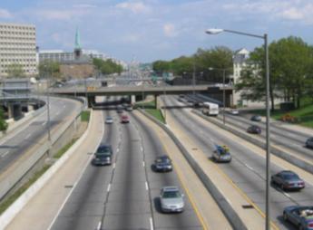
10 The Neighborhood Development Framework Street Function and Character Independence Ave 10 th St 7 th St 4 th St Civic Street Monumental Street Local City Street Local Neighborhood Street Regional Freeway I

11 Block Scale Energy Systems The Environmental Framework

12 The Environmental Framework District Scale Energy Systems 10 th St 7 th St 4 th St C St D St I-395 Energy Potential Federal/ Mixed Use Microgrid Potential Private Microgrid Central Utility Plant Existing System Potential Expansion Sewer Mining Heat 12
 could hold enough stormwater to provide")

13 The Environmental Framework District Scale Water Systems Large tanks (under 10 th Street) could hold enough stormwater to provide 71% of the total water used in the ecodistrict. C St D St 10 th St 7 th St 4 th St I th Street Cross Section with below ground tanks 13


14 The Environmental Framework Green Street Infrastructure Building Scale Strategies Green Roofs Edible Rooftops Green Walls Rain Gardens C St D St 10 th St 7 th St 4 th St Block /District Strategies Native Vegetation Healthy Soils Shade Trees Pervious Areas I-395 Green Corridor Enhanced Tree Canopy 14
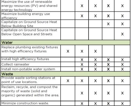

15 The Environmental Framework Energy, Water, and Waste at the Building Scale 15

16 Path to Sustainability - Today 16
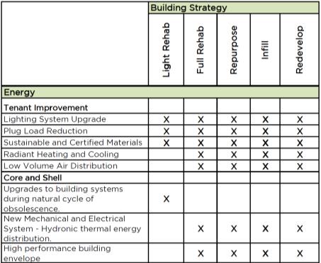
17 Path to Sustainability - Rehab Light Rehab Full Rehab Central Utility Plant Park Space 17
18 Path to Sustainability - Repurpose Repurpose Central Utility Plant Park Space 18

19 Path to Sustainability - Infill Infill Central Utility Plant Park Space 19
20 Path to Sustainability - Redevelop Redevelopment Solar Canopy Central Utility Plant Park Space 20
21 Path to Sustainability - Composite Light Rehab Full Rehab Repurpose Infill Redevelopment Solar Canopy Central Utility Plant Park Space 21
 Maryland Avenue/ L Enfant Intermodal Station and Park (VRE + Reservation 113) Southwest")
22 The Focus Areas Focus Areas: Guiding Successful Revitalization 10 th Street/Banneker Park Independence Quarter (Forrestal Complex) Maryland Avenue/ L Enfant Intermodal Station and Park (VRE + Reservation 113) Southwest Freeway 22

23 Focus Area - 10 th Street + Banneker Park Banneker USPS DOE Independence Ave Smithsonian Castle National Mall 23

24 Focus Area - 10 th Street + Banneker Park Banneker USPS Independence Ave Smithsonian Castle National Mall 24
 25")
25 Focus Area - 10 th Street, SW (looking towards the castle) 25 25
 26 26")
26 10 th Street, SW (looking towards the castle) 26 26


27 Focus Area - Independence Quarter National 27 Mall 27

28 Focus Area - Independence Quarter National Mall 51


29 Focus Area - Maryland Avenue GSA Maryland Ave Maryland Ave Wilbur Wright 52

30 Focus Area - Maryland Avenue GSA Maryland Ave Maryland Ave Wilbur Wright 53


31 Maryland Avenue Intermodal Station CSX/VRE/Virginia Ave Conceptual Study (ZGF) 31 31
 workers; Provides for 100,000 sf of new commercial services; Provides 1.")
32 Neighborhood Results Retains/improves 7.9M sf of federal office space; accommodates up to 19,000 additional workers; Creates 1.0M sf of offices for 5,000-6,000 private/federal) workers; Provides for 100,000 sf of new commercial services; Provides 1.8M sf residential/ hotel for 1,500 residents, and 240,000 visitors per year; Establishes 1.2M sf of museum space for 4-5 new cultural sites; Creates 14.3 acres of new/improved parks and plazas, 5 memorial sites; Reconnects street grid and creates 17 new intersections for easy accessibility; EXPANDS rail corridor and L Enfant Station to INCREASE regional commuter transit capacity. 32

33 Environmental Results Reduces the area s greenhouse gas emissions by 51%; Allows for the capture and reuse of ALL the rainwater in the Ecodistrict throughout the year; Reduces the potable water use by 70%; Increases the amount of waste diverted from the land from 35% to 80%; Transforms the federally-owned central utility plant into a HIGHLY EFFICIENT and FINANCIALLY SUCCESSFUL energy model. 33


34 Next Steps Economic Analysis Stormwater Infrastructure Study Interim 10 th Street Streetscape / Banneker Connection 34

35 More Information Visit 35
SW Ecodistrict A VISION PLAN FOR A MORE SUSTAINABLE FUTURE June 25, 2013
 Urban Land Institute The Past, Present and Future of Sustainable Urbanism in Southwest DC SW Ecodistrict A VISION PLAN FOR A MORE SUSTAINABLE FUTURE June 25, 2013 Study Area The National Mall DOE FAA FAA
Learning Objectives. Introduction. Design at an Ecodistrict Scale can Change Washington, DC s Landscape
 Learning Objectives Design at an Ecodistrict Scale can Change Washington, DC s Landscape Presenters Elizabeth Miller, ASLA, National Capital Planning Commission Diane Sullivan, National Capital Planning
EcoDistricts PERFORMANCE-BASED URBAN DESIGN APA WEBINAR JULY 10, 2015 / 1:00 2:30 PM EASTERN
 EcoDistricts PERFORMANCE-BASED URBAN DESIGN APA WEBINAR JULY 10, 2015 / 1:00 2:30 PM EASTERN EcoDistricts Performance-Based Urban Design A FOUNDATION FOR THE ECODISTRICT CONCEPT Urban Design and Historic
OF SOUTHWEST ECODISTIRCT
 SOUTHWEST ECODISTRICT WASHINGTON D.C., USA JULY, 2017 SNAPSHOT PROJECT TYPE: Urban Revitalization SITE SIZE: 110 acres ECONOMY: - Reduce federal operating expenses and federal lease expenses - Generate
THE NEIGHBORHOOD TODAY
 THE NEIGHBORHOOD TODAY CORE AREA VISION How are we Good Urbanism A Site s DNA thinking about Elements of great Unique elements urban communities embedded in a place the site and design? ELEMENTS LIKE:
Rock Spring Master Plan Community Meeting #8: Preliminary Recommendations
 Rock Spring Master Plan Community Meeting #8: Preliminary Recommendations July 18, 2016 Ι Walter Johnson High School Andrea Gilles, andrea.gilles@montgomeryplanning.org Ι www.montgomeryplanning.org/community/rockspring/
Marcel C. Acosta, AICP Executive Director National Capital Planning Commission th Street, NW North Lobby, Suite 500 Washington, D.C.
 Founded 1923 Chair Nancy J. MacWood Vice-Chair Monte Edwards Secretary Meg Maguire Treasurer Carol F. Aten Trustees Judy Chesser Dorothy Douglas Bobbie Faul-Zeitler Alma Gates Stephen Hansen Erik Hein
Courthouse Square Planning & Urban Design Study. Courthouse Square Working Group #13 October 15, 2014
 Courthouse Square Planning & Urban Design Study Courthouse Square Working Group #13 October 15, 2014 1 Courthouse Square Process Working Group Community Courthouse Square Advisory Groups & Civic Associations
LEED-ND 101: Practical Strategies for Achieving Sustainability Goals. Travis Parker Lakewood Planning Director
 LEED-ND 101: Practical Strategies for Achieving Sustainability Goals Travis Parker Lakewood Planning Director Metro Vision Idea Exchange Oct 11, 2012 West Corridor Stations West Corridor Overview West
Transportation. Strategies for Action
 Transportation A major priority for the Overlake Neighborhood is to develop a multimodal transportation system. To achieve this system, a balance has to be found among travel, circulation and access needs;
FUTURE LAND USE ELEMENT
 FUTURE LAND USE ELEMENT GOAL I: To create and sustain a great place to live, play, and prosper Objective 1: The City of Ocala shall incorporate the principles and strategies of the Ocala 2035 Vision into
DRAFT ROOSEVELT ROAD. District Recommendations. Figure 5.23 The Roosevelt Road Corridor
 CHAPTER 5 Figure 5.23 The Road Corridor Road will develop as a mixed-use corridor, emphasizing regional retail, west of the river and mixed-use development east of the river. KEY RECOMMENDATIONS 1. High
Northwest Rail Corridor and US 36 BRT Development Oriented Transit Analysis 4.4 STATION AREA FINDINGS
 4.4 STATION AREA FINDINGS Each station is different, and each one requires a separate set of recommendations based on the vision for the site. This section outlines an initial TOD strategy and recommendations
Sub Area 2: Downtown Overland Park
 Downtown 132 2.12 encompasses over 600 acres and extends between 71st Street and 87 th Street including Downtown Overland Park. The area is home to several individual historic sites and structures, including
BROOKLYN PARK / 85TH AVE LRT STATION CDI DEVELOPMENT GUIDELINES DRAFT
 August 2018 Page intentionally left blank The Brooklyn Park Library adjacent to the 85th Ave LRT Station Area. OVERVIEW The Blue Line LRT Extension / Bottineau corridor offers a unique opportunity to leverage
Multimodal Station Planning Working Session Rebuilding a Better I-84 in Hartford. August 10, 2017
 Multimodal Station Planning Working Session Rebuilding a Better I-84 in Hartford August 10, 2017 Station Urban Design Principles + Guidelines Station Urban Design Principles + Guidelines The station should
Planning for TOD Implementation at a Corridor Scale
 Planning for TOD Implementation at a Corridor Scale Catherine Cox Blair, Reconnecting America Presentation to DRCOG and the Sustainable Communities Initiative May 14, 2012 What is Reconnecting America?
Study Area. Capitol Way. Greening America s Capitals 11/13/2014. A Greening America s Capitals Project
 Olympia, WA: Greening Capitol Way Supporting Communities move towards sustainability is a priority for the federal government. A Greening America s Capitals Project Office of Sustainable Communities U.S.
THE 355/270 CORRIDOR:
 THE 355/270 CORRIDOR: Strategic Ideas for Sustaining a Livable Work Place Project Summary ACCESS LIFE DESIGN HEALTH WORK Montgomery County Planning Department The Maryland-National Capital Park and Planning
the west loop HOME TO 5,000 NEW DOGS
 the west loop the west loop HOME TO 5,000 NEW DOGS the west loop HOME TO 5,000 NEW DOGS AND 20,000 NEW RESIDENTS outline: the west loop now the vision how do we get there? opportunity LEVERAGE TRANSIT
An Opportunity for a More Comprehensive Approach to Sustainable Design
 By Johanna Brickman EcoDistricts An Opportunity for a More Comprehensive Approach to Sustainable Design I: Introduction Even as the concept of sustainable design spreads, and tools like the USGBC s LEED
Historic Preservation Preserve, restore or adaptively re-use historic structures and landscapes.
 Checklist for New Construction Developers of building projects in the Loring Park Neighborhood are encouraged to pursue the standards that are identified below. For large projects requiring special allowances,
Seneca Meadows. Block 4 Locate office, technology, and medical development adjacent to I Screen views of garage structures from I-270.
 Seneca Meadows Seneca Meadows has an industrial park in its southern end and a mixed-use employment area planned for the north end. The district benefits from extensive I-270 visibility, stream valley
Planning for TOD Implementation at a Corridor Scale
 Planning for TOD Implementation at a Corridor Scale Bill Sadler, Reconnecting America Presentation to Gold Line Corridor Working Group July 2, 2013 What is Reconnecting America? Reconnecting America is
Northwest commuter rail station US 36 BRT. Westminster Station
 Northwest commuter rail station Westminster Station US 36 BRT Westminster Center US 36 & Church Ranch Broomfield Flatiron/96 th St. US 36 & McCaslin Table Mesa Boulder Junction 13-month effort that will
ROBBINSDALE LRT STATION CDI DEVELOPMENT GUIDELINES
 August 2018 OVERVIEW The City of Robbinsdale has a prime-opportunity site in the middle of the 13 mile stretch of the Bottineau LRT corridor / Blue Line extension. Robbinsdale offers a prominent, vital,
Partnerships in Transportation Transit-oriented Development The Return on Investment
 Partnerships in Transportation Transit-oriented Development The Return on Investment David M. Taylor, CNU Senior Vice President National Director, Sustainable Transportation Solutions Transit and Development
Robbinsdale LRT Station. CDI Development Guidelines. August Overview
 Robbinsdale LRT Station August 2018 Overview The City of Robbinsdale may have the coolest opportunity site along the 13 mile stretch of the Bottineau LRT corridor / Blue Line extension. Located a block
PIKE PINE RENAISSANCE: ACT ONE. October 19, 2017
 PIKE PINE RENAISSANCE: ACT ONE October 19, 2017 WATERFRONT SEATTLE PROGRAM PROJECT INTRODUCTION Pike and Pine streets, between First and Melrose avenues Pedestrian and streetscape improvements Budget:
City of Ennis. Downtown Master Plan Catalyst Projects
 City of Ennis Downtown Master Plan Catalyst Projects Revised Framework Plan REVISED Project Types and Descriptions Project Types A. Visitor Attracting Projects: Projects in this category are intended to
DRAFT. 10% Common Open Space
 % OF CHARLOTTE IS CATEGORIZED AS A. LAND USES : Placeholder map displaying location of Place Type GOALS: Accommodate XX% of future growth. Provide a concentration of primarily commercial and civic activity
Silverdale Regional Center
 Silverdale Regional Center Vision for Silverdale Regional Center The Silverdale Regional Center Plan (Plan) will guide the evolution of the Silverdale Regional Center from a collection of strip malls and
b r a n c h av e n u e tr a n s it co r r i d o r r e vita lization pl a n a m o d el fo r s u b u r ban retro fit
 b r a n c h av e n u e tr a n s it co r r i d o r r e vita lization pl a n a m o d el fo r s u b u r ban retro fit P R I N C E G EO RG E S CO U NT Y, M D ADO PTED 0 p R O J E C T C AT E G O R Y : U R B
Stakeholders Advisory Working Groups (SAWGs) Smart Growth and TOD Land Use (#11) SAWG Meeting
 Smart Growth and TOD Land Use (#11) SAWG Meeting") Presentation - Part II Tappan Zee Bridge/I-287 Corridor Project July 21, 2010 Slide 1. David Kooris (Regional Plan Association) welcomed members of the Land Use Stakeholders Advisory Working Groups (SAWGs)
Presentation - Part II Tappan Zee Bridge/I-287 Corridor Project July 21, 2010 Slide 1. David Kooris (Regional Plan Association) welcomed members of the Land Use Stakeholders Advisory Working Groups (SAWGs)
West Broadway Transit Study Initial Screening of Alternatives Memo
 West Broadway Transit Study Initial Screening of Alternatives Memo 5/22/2015 Prepared by the SRF Consulting Group Team for Table of Contents Purpose... 1 Methodology... 1 Screening... 5 Screening Criteria...
Workshop #3 June 13, 2016
 Downtown Ocoee Master Plan Workshop #3 June 13, 2016 Our Team Our Team and Tonight s Goal Quick Recap: Why a Downtown Plan? How are we developing the plan? How can you still be involved? What s left to
Status Report: MD 355 Project
 Status Report: MD 355 Project OCTOBER 2006 M-NCPPC MONTGOMERY COUNTY PLANNING DEPARTMENT Summary of Community Comments, and break to the Results of the MD 355 Participation Session Brookside Gardens -
Prince George s County Economic Development Corporation David Iannucci President & CEO
 Prince George s County Economic Development Corporation David Iannucci President & CEO WBC REGIONAL ECONOMIC DEVELOPMENT FORUM THE FUTURE OF PRINCE GEORGE S COUNTY Wednesday, March 6, 2019 Why Prince George
Public Meeting: July 11, 2016
 Public Meeting: July 11, 2016 MONTGOMERY COUNTY PLANNING DEPARTMENT Maryland-National Capital Park and Planning Commission Tonight s Agenda Preliminary Recommendations Background and Context 2009 Twinbrook
Preliminary Recommendations Tk Takoma/Langley Crossroads Sector Plan
 Preliminary Recommendations Tk Takoma/Langley Crossroads Sector Plan Vision is to achieve a Transit Oriented, pedestrian friendly Community that Celebrates and builds upon the cultural Diversity of the
It is about sustainable development. A sustainable education and research center for our city.
 It is about sustainable development A sustainable education and research center for our city. It is about sustainable development It is about building community A new vision Located in the heart of Downtown
Courthouse Square Planning & Urban Design Study. Clarendon / Courthouse Civic Association October 21, 2014
 Courthouse Square Planning & Urban Design Study Clarendon / Courthouse Civic Association October 21, 2014 1 Courthouse Square Process Working Group Community Courthouse Square Advisory Groups & Civic Associations
U T D N o r t h C a m p u s T O D and D o w n t o w n D e n t o n T O D
 U n i v e r s i t y o f T e x a s a t D a l l a s C i t y o f R i c h a r d s o n U T D N o r t h C a m p u s T O D and D o w n t o w n D e n t o n T O D Rick Leisner, AICP Assistant Director of Development
SPRINGHILL LAKE TRANSIT VILLAGE
 Greenbelt Metro Area Sector Plan - Subarea Design Policies and Guidelines - Springhill Lake Transit Village 113 SPRINGHILL LAKE TRANSIT VILLAGE Residential Neighborhood and Village Center CONCEPT Springhill
The transportation system in a community is an
 7 TRANSPORTATION The transportation system in a community is an important factor contributing to the quality of life of the residents. Without a sound transportation system to bring both goods and patrons
City of Fort Lauderdale UPTOWN URBAN VILLAGE. Public Workshop December 7, 2016
 Public Workshop December 7, 2016 Workshop Agenda Introductions Project Presentation o o o History Project Scope/Timeline Character of Study Area o o o o Land Use Public Realm/Pedestrian Mobility Multimodal
Courthouse Square Planning & Urban Design Study
 Courthouse Square Planning & Urban Design Study Pedestrian Advisory Committee November 12, 2014 Kris Krider, AICP, Planning Supervisor Center for Urban Design and Research Department of Community Planning,
Rosslyn Plaza PDSP (SP #422) SPRC Staff Presentation
 SPRC Staff Presentation") Rosslyn Plaza PDSP (SP #422) SPRC Staff Presentation ote Guiding Principles included in this document are taken from the latest working draft of the Guiding Principles dated. The illustrations included
Rosslyn Plaza PDSP (SP #422) SPRC Staff Presentation ote Guiding Principles included in this document are taken from the latest working draft of the Guiding Principles dated. The illustrations included
RIVERSIDE, Newton MA June 9, 2011
 June 9, 2011 TONIGHT S AGENDA: 1.Project Update (5 min.) 2.Master Plan Update (10 min.) 3.Environmental Update (5 min.) 4.Traffic Plan Update (25 min.) Questions PROJECT STATUS UPDATE Responding / Clarifying
EXISTING PLANS Harriet Festing Center for Neighborhood Technology Midlothian Community Meeting March 12, 2015
 EXISTING PLANS Harriet Festing Center for Neighborhood Technology Midlothian Community Meeting March 12, 2015 BENEFITS Bring economic, community + environmental benefits Enhance property values Use
Corridors. Re-vitalize our Corridors and Gateways
 Corridors Re-vitalize our Corridors and Gateways Artist s rendering from the 287 Strategic Plan, 2015 Corridors are the major throughways of Loveland but they also provide important commercial, community
NEIGHBORHOOD DESIGN ELEMENT
 NEIGHBORHOOD DESIGN ELEMENT INTRODUCTION The following recommendations constitute an urban design oriented "neighborhood analysis" of Plantation. It is an optional Comprehensive Plan Element. The five
Promoting Economic Development Through Upfront SEPA Review: Lessons from South Downtown Tacoma
 Promoting Economic Development Through Upfront SEPA Review: Lessons from South Downtown Tacoma 1 This session will focus on the City of Tacoma s South Downtown Subarea Plan and associated Non-Project SEPA
Equitable Growth Through TOD Planning
 Equitable Growth Through TOD Planning Community Meeting # 2 November 2017 Goals Objectives Extend investment from downtown Connect neighborhoods physically and economically Enhance places based on local
REVIEW AND EVALUATION OF REGIONAL LAND USE
 REVIEW AND EVALUATION OF REGIONAL LAND USE AND TRANSPORTATION SCENARIOS #220831 Environmental Justice Task Force October 7, 2014 VISION 2050 Process Development of Guiding Vision for Land Use and Transportation
EcoVerde MADISON TO DOWNTOWN TO BEACH. Legend Highway Major Connection Major Street Local Street Proposed Access. Response to Tropicana Field RFP
 EcoVerde TO BEACH 275 16th Street North 16th Street South 13th Street North 13th Street South 11th Street North 11th Street South 1st Avenue North Central Avenue 1st Avenue South TO DOWNTOWN 2nd Avenue
Ivywild On The Creek PRELIMINARY CREEK DISTRICT MASTER PLAN
 Ivywild On The Creek PRELIMINARY CREEK DISTRICT MASTER PLAN Introduction: Rejuvenating an extraordinary Creekside neighborhood THE CREEKSIDE DISTRICT The Ivywild On The Creek Neighborhood District Master
Urban Design Manual PLANNING AROUND RAPID TRANSIT STATIONS (PARTS) Introduction. Station Study Areas
 Introduction. Station Study Areas") 111111 PLANNING AROUND RAPID TRANSIT STATIONS (PARTS) Introduction The ION rapid transit system will link Waterloo, Kitchener and Cambridge through a central transit corridor (CTC). There are a number
111111 PLANNING AROUND RAPID TRANSIT STATIONS (PARTS) Introduction The ION rapid transit system will link Waterloo, Kitchener and Cambridge through a central transit corridor (CTC). There are a number
Draft Bergamot Area Plan
 ATTACHMENT 1 Draft Bergamot Area Plan Taskforce on the Environment April 15, 2013 www.bergamotplan.net 1 Overview WHAT IS THE BERGAMOT AREA PLAN? A Community-Based Planning Document Guiding the Future
Elliot Park 4. Neighborhood Master Plan. The Master Plan
 Elliot Park 4 Neighborhood Master Plan August 2002 Why Master Plan? Construction cranes signal new growth downtown as the backdrop to this smaller scale, quiet neighborhood. Do nothing or plan for the
Planning for TOD Implementation at a Corridor Scale
 Planning for TOD Implementation at a Corridor Scale Catherine Cox Blair, Reconnecting America Presentation to Northwest Corridor Working Group November 6, 2013 What is Reconnecting America? Reconnecting
José Campos Manager of Planning and Design Review SPUR San José Symposium October 12, 2018
 1 Transbay: Freeways to New Ways José Campos Manager of Planning and Design Review SPUR San José Symposium October 12, 2018 2 Transbay freeway land pre-1989 3 1989 Loma Prieta Earthquake 4 TRANSBAY c.
SMITHSONIAN INSTITUTION SOUTH MALL CAMPUS MASTER PLAN PUBLIC SCOPING REPORT. June Prepared by:
 SMITHSONIAN INSTITUTION SOUTH MALL CAMPUS MASTER PLAN PUBLIC SCOPING REPORT June 2015 Prepared by: Table of Contents 1) PROJECT SUMMARY... 3 2) PUBLIC SCOPING PROCESS SUMMARY... 4 a) Public Scoping Meeting...
Subarea 4 Indian Creek. Vision The combination of park networks and transportation amenities make Subarea 4 the greenest hub in the Corridor.
 indian creek 180 extends south from 101st Street to I-435. The I-435 and Metcalf intersection is one of the primary intersections in the Kansas City Metro Area. The area includes several residential neighborhoods
SMITHSONIAN INSTITUTION SOUTH MALL CAMPUS MASTER PLAN PUBLIC SCOPING REPORT. June Prepared by:
 SMITHSONIAN INSTITUTION SOUTH MALL CAMPUS MASTER PLAN PUBLIC SCOPING REPORT June 2015 Prepared by: The Smithsonian Institution South Mall Campus Master Plan Public Scoping Report Table of Contents 1)
Lehigh Acres Land Development Regulations Community Planning Project
 Lehigh Acres Land Development Regulations Planning Effort Summary In July, 2010 Commissioner Frank Mann invited the Lehigh Acres community to start discussing how to achieve their recently adopted community
Project Overview. Washington s Most Exciting New Destination for Office and Retail PROPERTY GROUP PARTNERS
 Washington s Most Exciting New Destination for Office and Retail PROPERTY GROUP PARTNERS Washington s Most Exciting New Destination for Office and Retail 2.2 Million Square Feet 3 New City Blocks on a
WALTER RAND TRANSPORTATION CENTER
 WALTER RAND TRANSPORTATION CENTER PLANNING AND DESIGN STUDY Public Meeting May 25, 2017 TONIGHT S AGENDA Introduction and Welcome Project Objectives The Study Area: WRTC and its Context Circulation Assessment
East Central Area Plan
 East Central Area Plan Steering Committee Meeting March 8 th, 2018 CHUN Tears McFarlane House Vision Statement Development Opportunities Analysis Vision Elements 1. Equitable, Affordable and Inclusive
KCATA Transit Oriented Development Initiatives
 KCATA Transit Oriented Development Initiatives KCATA: Regional Transportation Authority Created by bi-state compact Approved by Congress 7 County service area Quasi-governmental with broad powers Power
Project Overview. Washington s Exciting Destination for Office & Retail. For More Information, Visit CapitolCrossingDC.com PROPERTY GROUP PARTNERS
 Washington s Exciting Destination for Office & Retail PROPERTY GROUP PARTNERS For More Information, Visit Washington D.C. s Landmark Destination Project Highlights 2.2 Million Square Feet 3 New City Blocks
PORT OF VANCOUVER WATERFRONT DEVELOPMENT. Concept Development Plan City Center Redevelopment Authority April 20, 2017
 PORT OF VANCOUVER WATERFRONT DEVELOPMENT Concept Development Plan City Center Redevelopment Authority April 20, 2017 Port History PORT ESTABLISHED 1912 TERMINAL 1 ACQUIRED 1925 GWM SIGNS LEASE 1935 HARBOR
Applicant Name Phone / Fax / Address City State Zip Code . Property Owner Phone / Fax / Address City State Zip Code
 Master Development Plan Application Community Development Department City of Redmond 411 SW 9 th Street Redmond, Oregon 97756 541-923-7721 541-548-0706 FAX Master Development Plan Fee $38,862.52 File Number
Tyvola & Archdale Transit Station Area Plan. May 15, 2008
 Tyvola & Archdale Transit Station Area Plan First Public Meeting May 15, 2008 Presentation Outline 1. Purpose and Process 2. Station Area Overview 3. Plan Recommendations Vision Land Use Transportation
Hockessin Community Redevelopment Plan
 Hockessin Community Redevelopment Plan 3.1 Introduction The Community Redevelopment Plan for the Village of Hockessin is the result of the people s vision for a distinct village center that serves as the
2015 Campus Master Plan Update
 September 15, 2015 2015 Campus Master Plan Update Campus and Community Analysis Summary Presentation A G E N D A 1. Scope & Schedule of the Master Plan 2. Planning Principles & Draft Goals 3. Background
City of Bristol Route 6 Corridor Implementation Program
 City of Bristol Route 6 Corridor Implementation Program FITZGERALD & HALLIDAY, INC. Innovative Planning, Better Communities June 2017 Route 6 Corridor Plan IMPLEMENTATION PROGRAM The following Implementation
BRYN MAWR. Tier 2 Characteristics: Location: Lancaster Avenue from Old Lancaster Road on the east to Norwood Avenue on the west
 BRYN MAWR Tier 2 Characteristics: Transit-oriented Mixed use Along Lancaster Avenue Serve township-wide needs Civic space Employment centers Location: Lancaster Avenue from Old Lancaster Road on the east
City Center Specific Plan Amendments And Background Report City of Richmond. PLANNING COMMISION FINAL DRAFT January, 2001
 City Center Specific Plan Amendments And Background Report City of Richmond PLANNING COMMISION FINAL DRAFT January, 2001 TABLE OF CONTENTS Page LIST OF TABLES... LIST OF FIGURES... INDEX... OVERVIEW...
DOWNTOWN LOUISVILLE MASTER PLAN
 DOWNTOWN LOUISVILLE MASTER PLAN AGENDA Plan Process Update engagelouisville.com 5 Neighborhoods and 1 Riverfront Feedback and Update Strategies and Recommendations Implementation Next Steps SCHEDULE APRIL
INDEPENDENCE BOULEVARD AREA PLAN
 INDEPENDENCE BOULEVARD AREA PLAN Public Meeting October 28, 2008 Tonight s Agenda Introduction 4:00 4:05 Tom Warshauer Presentation 4:05 5:00 Blake Drury Group Exercises 5:00 5:50 All Wrap Up & Next Steps
EXPO LINE COMMUNITY WORKSHOPS NOVEMBER 27 TH & DECEMBER 3 RD Los Angeles Department of City Planning
 EXPO LINE COMMUNITY WORKSHOPS NOVEMBER 27 TH & DECEMBER 3 RD 2012 Los Angeles Department of City Planning Agenda for Tonight Open House 6:00 to 6:15pm Presentation and Questions 6:15 to 6:50 Small Group
Atlanta BeltLine. Subareas 9 & 10. Master Plan Updates. March 26, Washington Park Jamboree 1
 Atlanta BeltLine Subareas 9 & 10 Master Plan Updates March 26, 2018 Washington Park Jamboree 1 22 miles, connecting 45 neighborhoods 22 MILES of transit 46 MILES of streetscapes and complete streets 33
BRYN MAWR. Tier 2 Characteristics: Location: Lancaster Avenue from Old Lancaster Road on the east to Norwood Avenue on the west
 BRYN MAWR Tier 2 Characteristics: Transit-oriented Mixed use Along Lancaster Avenue Serve township-wide needs Civic space Employment centers Location: Lancaster Avenue from Old Lancaster Road on the east
Tyvola & Archdale Transit Station Area Plan. June 5, 2008
 Tyvola & Archdale Transit Station Area Plan Second Public Meeting June 5, 2008 Presentation Outline 1. Purpose and Process 2. Station Area Overview 3. Plan Recommendations 4. Comments Received and Proposed
NorthPoint, Inc. Community-Based Development Concept
 NorthPoint, Inc. Community-Based Development Concept 6.0.01 EXECUTIVE SUMMARY The NorthPoint Community Board Development concept is a community development strategy. It leverages NorthPoint s mission,
Section. Corridor Context & History
 2 Section National Arboretum Georgetown Downtown H STREET NE CORRIDOR Chinatown RFK Stadium National Mall U.S. Capitol Anascotia River ² Potomac River DC-295 Figure 2.1 (opposite page): Site Context Map
3.5 Principle 5/Response
 5 Principle 5/Response Existing street network Proposed street network Pedestrian street hierarchy Existing streets Existing Regional Arterial 4 Existing Street Network Existing and proposed streets Indicative
Subarea 5 Southern Gateway. Vision. Mobility The proposed street network will create developable blocks that are scaled appropriately for the area.
 southern gateway 194 Southern Gateway extends south of I-435 to 123 rd Street and includes the area past the Blue Valley Parkway division. This area is adjacent to major office centers such as the College
STEERING COMMITTEE MEETING # 5 SEPTEMBER 18, 2018
 STEERING COMMITTEE MEETING # 5 SEPTEMBER 18, 2018 STEERING COMMITTEE MEETING #5 AGENDA 1. Introduction 2. Market Conditions 3. Preliminary Development Concepts 4. Open Discussion 5. Next Steps PLANNING
A.1 New Policy Topic Areas
 A.1 New Policy Topic Areas TOPIC AREA #1 SUSTAINABILITY, OPEN SPACE & CONSERVATION Even though the term sustainability was not widely used when the General Plan was last updated, many sustainable policies
DRAFT. October Wheaton. Design Guidelines
 October 2011 DRAFT Wheaton Design Guidelines 2 Draft - Design Guidelines - Wheaton Sector Plan Contents 04 Section 1: Introduction 06 Section 2: Context 08 Section 3: Design Guidelines 09 Goal 1: Create
Attachment B Summary of Plan Alternatives Report
 Attachment B Summary of Plan Alternatives Report Based on community ideas and feedback to date, a series of draft alternative scenarios for the future of downtown s neighborhood districts have been created
Proposed Major Institution Master Plan Street Vacation. March 19, 2009
 Presentation to Seattle Design Commission Proposed Major Institution Master Plan Street Vacation March 19, 2009 1 Why We Need to Grow More children surviving with chronic disease increasing the demand
Little Mountain UDP Presentation
 Summary of UDP Evaluation of Dec 2015 Plan Dec 2015 Site Plan Transitional edges work well Central spine and permeability are strong Tree retention is good Establish Big Idea Sameness of built form contributes
III. Design Principles
 III. Design Principles The design of Bay Meadows Phase II has been guided by a series of Urban Design Principles. These principles, informed by consultant site analysis, City staff recommendations, and
The Baileys Planning District portion of the Comprehensive Plan contains site design recommendations for both the Baileys Crossroads Community
 The Baileys Planning District portion of the Comprehensive Plan contains site design recommendations for both the Baileys Crossroads Community Business Center and the Seven Corners Community Business Center.
1071 King Street West Zoning Amendment Application - Preliminary Report
 STAFF REPORT ACTION REQUIRED 1071 King Street West Zoning Amendment Application - Preliminary Report Date: August 9, 2012 To: From: Wards: Reference Number: Toronto and East York Community Council Director,
Planning and Design: Applied LID Techniques Redevelopments, Housing, Mixed Use, Infrastructure
 Civil Engineering Landscape Architecture Environmental Restoration Planning Planning and Design: Applied LID Techniques Redevelopments, Housing, Mixed Use, Infrastructure Peg Staeheli, ASLA, LEED AP March
PLANNING COMMISSION WORKSESSION AGENDA. City Hall Second Floor Conference Room 9027 Center Street. July 1, :30 PM
 MEMBERS Harry J. Clark, Chairperson Bruce Wood, Vice-Chairperson Russell Harrison Ken Johnson Robert W. Schilpp Martha Wilson PLANNING COMMISSION WORKSESSION AGENDA City Hall Second Floor Conference Room