Building out the Regional Growth Strategy in Surrey: a Strong Centre & a Connected Transit City
|
|
|
- Arron Young
- 5 years ago
- Views:
Transcription

1 Building out the Regional Growth Strategy in Surrey: a Strong Centre & a Connected Transit City

2 Surrey in the Metro Vancouver Region Regional Growth Strategy identifies Surrey as a major provider of housing & jobs for a growing region land available for new urban neighbourhoods relatively affordable family housing opportunity for higher density centres, linked by rapid transit Surrey City Centre identified as the second downtown of the region, focused on the South of Fraser sub-region

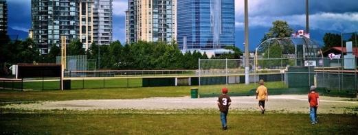
3 Context: Robust Population Growth Surrey will add 300,000 people and 160,000 jobs over the next 30 years. Expected population in 2045: 800,000 Current growth of +/- 10,000/year Increasing share of multifamily development
4 Demographics: Young and Diverse 4 22% of children born in BC are born in Surrey School District largest in BC: 72,000 students 26% of Surrey s population is under 19 years old Metro Vancouver average is 20% Diverse population: 42% of residents mother tongue is Punjabi, Chinese, Hindi or Tagalog

5 The Sustainability Charter 2.0

6 New Official Community Plan Major Themes: Stronger City & Town Centres Transit-supported development A Greener City
7 Housing Starts by Type for Surrey Average of 3,500 new dwelling units / year over the past 10 years 2016: 4,300 dwelling unit starts: 1,400 apartments (4 highrise towers, 6 lowrise) 1,400 townhouses 1,000 single family homes 500 new lots 500 replacement houses 500 secondary suites


8 Land use responses (priorities) City & Town Centres = 100,000 1 New neighbourhoods (NCPs) = 100,000 3 Infill / Transit Corridors = 100,000 2

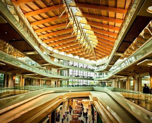
9 Surrey City Centre Plan Vision Statement A transformation from a suburban centre into a walkable high density, transit-oriented downtown. It will be a centre for major employment, educational, recreational and cultural activity linked by a green public network. The City Centre will be comprised of distinct neighbourhoods that are home to a diverse population.

10 City Centre Guiding Principles 1. Build Density & Mixed Use 2. Encourage Housing Diversity 3. Break Up the Block Size 4. Design Roads for Multiple Modes 5. Create Vibrant Urban Spaces 6. Promote Identity & Sense of Place 7. Encourage Office & Employment 8. Green the Downtown

11 Plan Components Land Use & Density 3.5 FAR cap removed in OCP up to 7.5 FAR + 20% density bonus, density focused on transit hubs Density calculated on gross site area to encourage street dedication through redevelopment Mixed use encouraged commercial ground floor required in core area near transit SF freeze areas to encourage densification
12 Plan Components Finer Grain Road Network

13 Plan Components Finer Grain Road Network

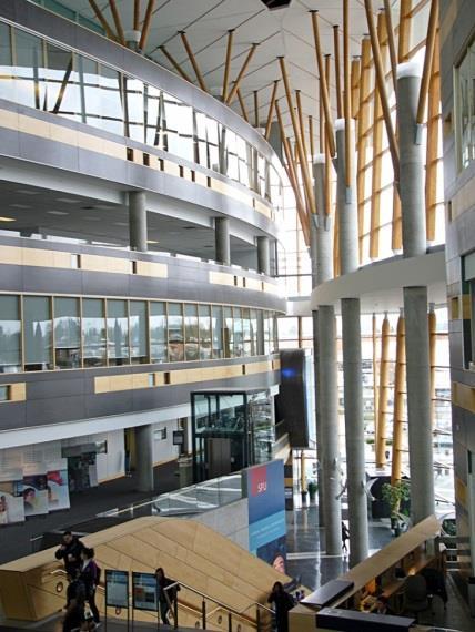
14 Civic Heart: relocating City Hall to the centre; creating a transit civic university nexus


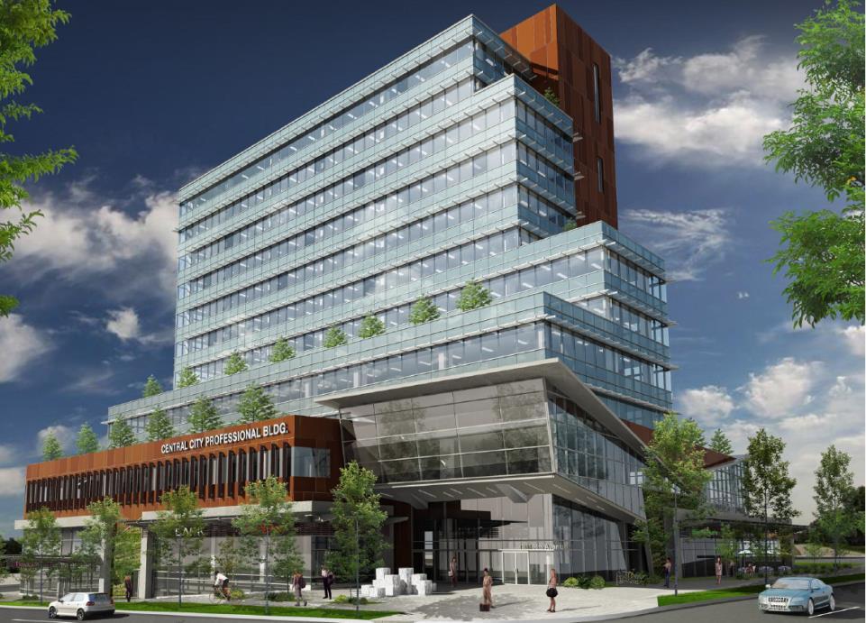
15 New City Hall: A catalyst for investment


16 Central Library A new living room for the community


17 Civic Plaza and 3 Civic Plaza Tower

18 Planning a University District

19 University Precinct / Transit Hub Eng. Science SFU Existing


20 Central Pedestrian Spine Urban City Centre connect public spaces, civic plaza with Surrey Central Plaza

21 Greening the Downtown
22 Plan Components Green the Downtown


23 Public Space for Public Life


24 Buildings that engage with the Street

25 Plan Components Roads for Multiple Modes
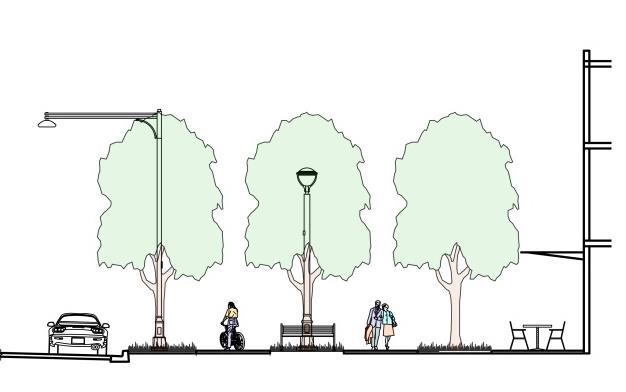

26 Plan Components Roads for Multiple Modes


27 Public sector: SFU, Fraser Health, RCMP


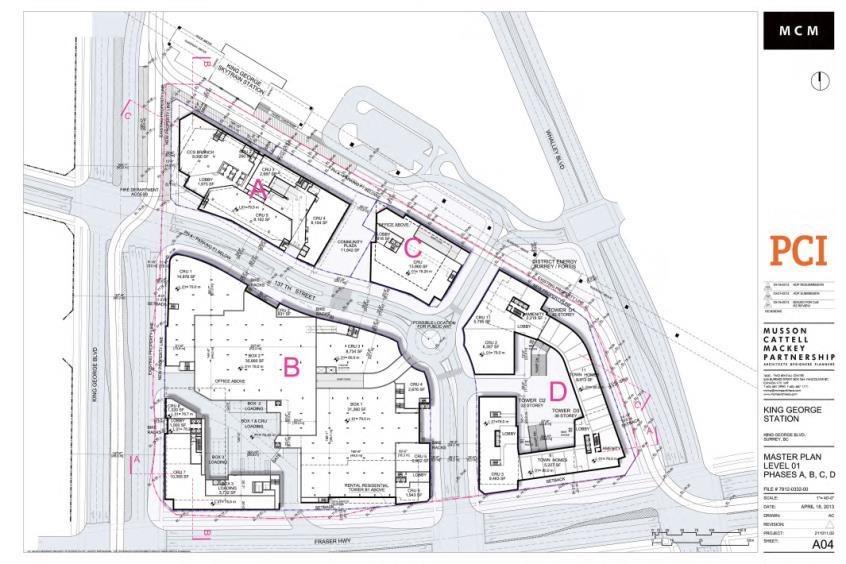
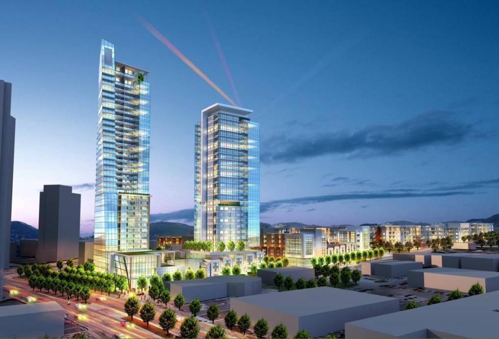
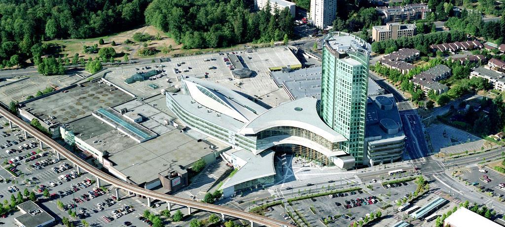
28 Selected Private Sector Projects Selected Private Sector Projects


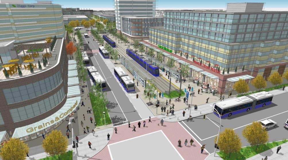
29 Selected Private Sector Projects PCI Bosa
30 Population & Employment Growth City Centre 2015 (est.) 2030 (proj.) 2045 (proj.) Population 32,000 54,000 76,000 Dwelling Units 16,000 28,000 40,000 Employment 24,000 36,000 48,000 ICI Floor Area 10.5M sf 15.0M sf 21.0M sf An average of 800 units with 1,500 residents are added each year in City Centre. This growth rate is expected to continue over the next 30 years.

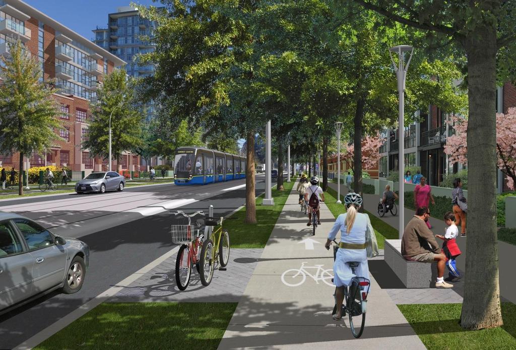
31 Future Development Scenario 2040
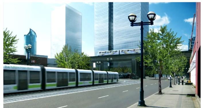
32 Connecting the City with LRT

33 Broadway subway Surrey LRT

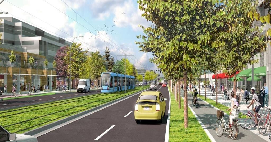
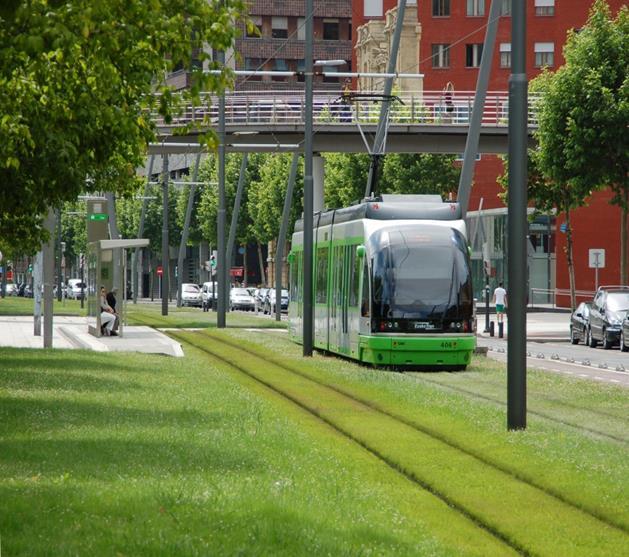
34 Surrey s transit vision: City-shaping light rail
35 Vision Statement Street-oriented LRT will transform Surrey into connected, complete and livable communities, making the City and region more vibrant, accessible, competitive and sustainable


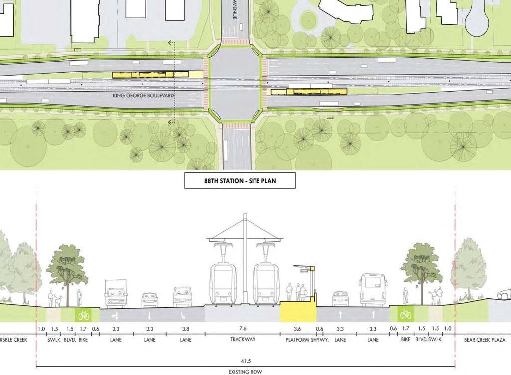
36 LRT Station Area Planning


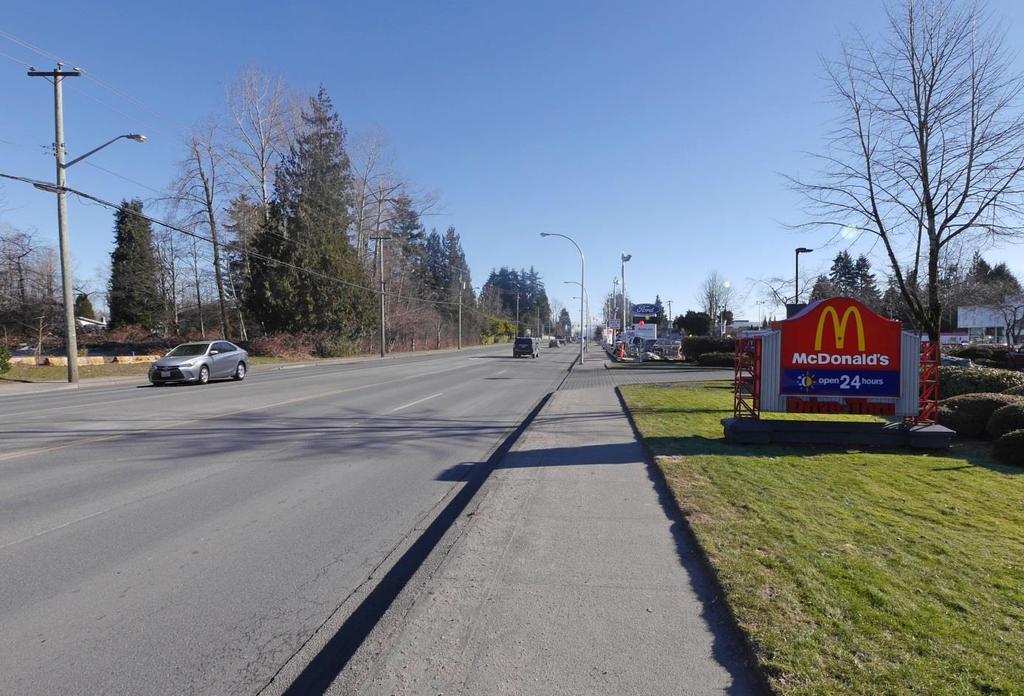
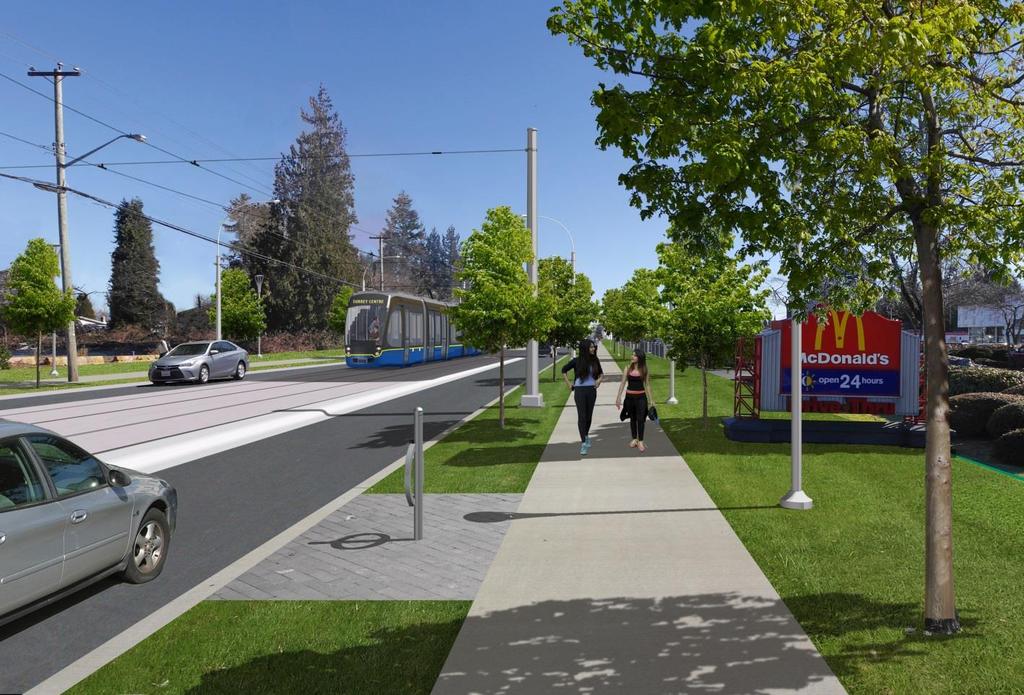
37 Newton Town Centre City-owned property along with TransLink property and private lands can be developed as a transitoriented, mixed use development around the planned terminus station, to a density of 3.5 FAR (calculated on the gross site area). Complex project including road realignments (137 St. and 71 Ave.) and the incorporation of transit infrastructure (LRT, bus exchange, bus layover)
38 104 Avenue Transformation
39 104 Avenue Transformation
40 104 Avenue Transformation
41 104 Avenue Transformation

42 50-year vision for a healthier City Connected green spaces Flexible density on transit routes Urban agriculture Gentle infill in existing neighbourhoods More jobs in employment areas Community learning centres as neighbourhood hubs
43 Questions & Discussion? Don Luymes, Director of Strategic Initiatives
3. Endorse the LRT vision in transforming Surrey into Connected-Complete-Livable communities, and more specifically, the official vision statement:
 CORPORATE REPORT NO: R038 COUNCIL DATE: February 20, 2017 REGULAR COUNCIL TO: Mayor & Council DATE: February 16, 2017 FROM: General Manager, Engineering FILE: 8740-01 SUBJECT: Surrey Light Rail Transit
NO: R035 COUNCIL DATE: FEBRUARY 24, 2014
 CORPORATE REPORT NO: R035 COUNCIL DATE: FEBRUARY 24, 2014 REGULAR COUNCIL TO: Mayor & Council DATE: February 24, 2014 FROM: General Manager, Planning and Development FILE: 6520-01 SUBJECT: Town Centre
NO: R230 COUNCIL DATE: October 24, LRT Corridor Planning Studies Terms of Reference
 CORPORATE REPORT NO: R230 COUNCIL DATE: October 24, 2016 REGULAR COUNCIL TO: Mayor & Council DATE: October 20, 2016 FROM: General Manager, Planning & Development General Manager, Engineering FILE: 6520-20
Cambie Corridor Planning Program Phase Two Draft Plan. Standing Committee on City Services and Budgets May 5, 2011
 Cambie Corridor Planning Program Phase Two Draft Plan Standing Committee on City Services and Budgets May 5, 2011 Cambie Corridor Program Terms of Reference approved July 2009 Land Use Transportation Energy
City of Vancouver Regional Context Statement Official Development Plan. (Adopted by By-law No , September 24, 2013)
") City of Vancouver Regional Context Statement Official Development Plan (Adopted by By-law No. 10789, September 24, 2013) Table of Contents Introduction GOAL 1 Create a Compact Urban Area STRATEGY 1.1
City of Vancouver Regional Context Statement Official Development Plan (Adopted by By-law No. 10789, September 24, 2013) Table of Contents Introduction GOAL 1 Create a Compact Urban Area STRATEGY 1.1
Metro Vancouver. Regional Growth. Strategy. Optimizing the Urban Footprint
 Metro Vancouver Regional Growth Metro Vancouver Fraser Valley Regional District Strategy USA Victoria Bellingham Optimizing the Urban Footprint 2011 Salish Sea Ecosystem Conference October 25, 2011 Terry
Create Policy Options Draft Plan Plan Approval. Public Consultation Events. Phase 2
 Background Grandview-Woodland Community Plan In the spring of 2012, the City of Vancouver embarked on a comprehensive community planning program in the Grandview-Woodland neighbourhood. The process has
BROOKLYN PARK / 85TH AVE LRT STATION CDI DEVELOPMENT GUIDELINES DRAFT
 August 2018 Page intentionally left blank The Brooklyn Park Library adjacent to the 85th Ave LRT Station Area. OVERVIEW The Blue Line LRT Extension / Bottineau corridor offers a unique opportunity to leverage
THE NEIGHBORHOOD TODAY
 THE NEIGHBORHOOD TODAY CORE AREA VISION How are we Good Urbanism A Site s DNA thinking about Elements of great Unique elements urban communities embedded in a place the site and design? ELEMENTS LIKE:
[PLANNING RATIONALE] For Site Plan Control and Lifting of Holding Zone By-Law 101 Champagne Avenue. May 23, 2014
![[PLANNING RATIONALE] For Site Plan Control and Lifting of Holding Zone By-Law 101 Champagne Avenue. May 23, 2014](/thumbs/75/71599615.jpg "[PLANNING RATIONALE] For Site Plan Control and Lifting of Holding Zone By-Law 101 Champagne Avenue. May 23, 2014") [PLANNING RATIONALE] For Site Plan Control and Lifting of Holding Zone By-Law 101 Champagne Avenue May 23, 2014 Contents 1.0 Introduction... 2 2.0 Site Context... 2 2.1 Adjacent Uses... 2 Figure 1: Site
[PLANNING RATIONALE] For Site Plan Control and Lifting of Holding Zone By-Law 101 Champagne Avenue May 23, 2014 Contents 1.0 Introduction... 2 2.0 Site Context... 2 2.1 Adjacent Uses... 2 Figure 1: Site
The River Hub: NEW BUILDINGS
 Summary The River Hub includes 6 municipalities that all boarder the Fraser River. Combined, they are expected to double in population over the next 50 years. To accommodate this new population, 138,831
Newton Town Centre. Land Use, Urban Design & Transportation Plan
 Newton Town Centre Land Use, Urban Design & Transportation Plan Public Workshop - June 2-4, 2009 6:15 6:30 Sign-in & conversations Tonight s Agenda 6:30 6:55 Project introduction and summary of previous
New Partners for Smart Growth Conference February 5, 2010
 Dan Stroh, Planning Director City of Bellevue Planning and Community Development Bellevue, WA New Partners for Smart Growth Conference February 5, 2010 Summary of Project Long-range plan update for Bel-Red
WITNESS STATEMENT Of. Ronald Blake. On behalf of the Intervenor The Corporation of the City of Markham
 Filed: 2013-06028 EB-2012-0451 Exhibit L.EGD.COM.2 Page 1 of 7 WITNESS STATEMENT Of Ronald Blake On behalf of the Intervenor The Corporation of the City of Markham In the matter of an application by Enbridge
TO: Mayor & Council DATE: April 12, The Planning and Development Department and the Engineering Department recommend that Council:
 CORPORATE REPORT NO: R080 COUNCIL DATE: April 12, 2010 REGULAR COUNCIL TO: Mayor & Council DATE: April 12, 2010 FROM: SUBJECT: General Manager, Planning and Development General Manager, Engineering Neighbourhood
178 Carruthers Properties Inc.
 178 Carruthers Properties Inc. Planning Rationale for 178 Carruthers Avenue Site Plan Control Application June 2014 Table of Contents 1.0 Introduction 2.0 Overview of Subject Property 3.0 Current Zoning
ELMVALE ACRES SHOPPING CENTRE MASTER PLAN
 ELMVALE ACRES SHOPPING CENTRE MASTER PLAN Contents 1.0 INTRODUCTION... 2 2.0 LOCATION... 2 3.0 EXISTING CONTEXT... 2 4.0 VISION & GUIDING PRINCIPLES... 2 5.0 LAND USE AND BUILT FORM... 4 5.1 St. Laurent
GO Station Mobility Hubs: Draft Precinct Plans. Committee of the Whole July 12, 2018
 GO Station Mobility Hubs: Draft Precinct Plans Committee of the Whole July 12, 2018 Purpose of this Workshop Present Draft Precinct Plans for the 3 GO Station Mobility Hubs Continue the conversations that
PUBLIC OPEN HOUSE HURONTARIO-MAIN CORRIDOR SECONDARY PLAN
 PUBLIC OPEN HOUSE HURONTARIO-MAIN CORRIDOR SECONDARY PLAN Tuesday, February 28, 2012 6pm 9pm 1 st Floor Atrium, City Hall 2 Wellington Street West, Brampton 1 POLICY FRAMEWORK The 2006 Provincial Growth
Plano Tomorrow Vision and Policies
 Plano Tomorrow Vision and Policies PLANO TOMORROW PILLARS The Built Environment The Social Environment The Natural Environment The Economic Environment Land Use and Urban Design Transportation Housing
1.3 TRANSIT VISION 2040 FROM VISION TO ACTION THEME 1: PUTTING TRANSIT AT THE CENTRE OF COMMUNITIES. Fully integrate transit with community planning
 TRANSIT VISION 2040 FROM VISION TO ACTION TRANSIT VISION 2040 defines a future in which public transit maximizes its contribution to quality of life with benefits that support a vibrant and equitable society,
4- PA - LD - LIVELY DOWNTOWN. LD - Background
 4- PA - LD - LIVELY DOWNTOWN LD - Background The downtown has been the service centre for the community since the city s inception and the area continues to supply people with their personal services,
Public Open House #1
 Public Open House #1 TONIGHT S AGENDA Welcome Project Overview The Big Picture The Station Area The Analysis Thoughts about Future Change Breakout Group Discussions Summation / Next Steps Project Overview
Official Plan Review
 Official Plan Review Summary Report - The Built Environment August 2014 Part 1: Introduction Planning for a healthy, prosperous and sustainable community is an important goal for our municipality. From
Cambie Corridor Planning Program Phase One. Standing Committee on Transportation and Traffic January 19, 2010
 Cambie Corridor Planning Program Phase One Standing Committee on Transportation and Traffic January 19, 2010 Work Program Terms of Reference approved July 2009 Land Use Transportation Energy Cambie Corridor
01 the vision NEW LYNN IS WAITING FOR THE GREAT LEAP FORWARD
 [A] FRAMEWORK 01 the vision 02 the framework 03 urban design principles 04 c o n t e x t 05 issues a n d o p p o r t u n i t i e s 06 creating a t.o.d. 07 key recommendations 08 seven strategic areas of
WELCOME. The Yonge-Eglinton area has experienced significant growth and change in the last decade.
 WELCOME DID YOU KNOW? MIDTOWN IS REPRESENTED BY 3 CITY COUNCILLORS: WARD 16 EGLINTON-LAWRENCE WARD 22 ST. PAUL S WARD 25 DON VALLEY WEST Midtown in Focus: Building a Livable Yonge-Eglinton The Yonge-Eglinton
Public Open House. Overview of the Downtown Plan Official Plan Amendment April 23, 2018
 Public Open House Overview of the Downtown Plan Official Plan Amendment April 23, 2018 1 A 25-Year Plan for Downtown To ensure growth contributes positively to Toronto s Downtown as a great place to live,
3. Urban Design in the Central Area
 3. Urban Design in the Central Area The Central Area Planning and Design Group assumes the responsibility to promote high quality urban and architectural design in the Central Area, plan and ensure the
CITY OF LANGLEY OFFICIAL COMMUNITY PLAN BYLAW, 2005, NO APPENDIX II - REGIONAL CONTEXT MAP
 CITY OF LANGLEY OFFICIAL COMMUNITY PLAN BYLAW, 2005, NO. 2600 APPENDIX II - REGIONAL CONTEXT MAP ± Legend Agricultural Mixed Employment Industrial Conservation & Recreation Regional City Centre Urban Containment
Urban Design Manual PLANNING AROUND RAPID TRANSIT STATIONS (PARTS) Introduction. Station Study Areas
 Introduction. Station Study Areas") 111111 PLANNING AROUND RAPID TRANSIT STATIONS (PARTS) Introduction The ION rapid transit system will link Waterloo, Kitchener and Cambridge through a central transit corridor (CTC). There are a number
111111 PLANNING AROUND RAPID TRANSIT STATIONS (PARTS) Introduction The ION rapid transit system will link Waterloo, Kitchener and Cambridge through a central transit corridor (CTC). There are a number
REVIEW AND EVALUATION OF REGIONAL LAND USE
 REVIEW AND EVALUATION OF REGIONAL LAND USE AND TRANSPORTATION SCENARIOS #220831 Environmental Justice Task Force October 7, 2014 VISION 2050 Process Development of Guiding Vision for Land Use and Transportation
ROBBINSDALE LRT STATION CDI DEVELOPMENT GUIDELINES
 August 2018 OVERVIEW The City of Robbinsdale has a prime-opportunity site in the middle of the 13 mile stretch of the Bottineau LRT corridor / Blue Line extension. Robbinsdale offers a prominent, vital,
Robbinsdale LRT Station. CDI Development Guidelines. August Overview
 Robbinsdale LRT Station August 2018 Overview The City of Robbinsdale may have the coolest opportunity site along the 13 mile stretch of the Bottineau LRT corridor / Blue Line extension. Located a block
Welcome to the Oakridge Centre Open House
 Welcome to the Oakridge Centre Open House Why is the City hosting this event? This open house is to inform you of a rezoning application submitted to the City of Vancouver to amend the existing CD-1 (Comprehensive
Create a connected ecological network. Connect districts with transit. Let the centre define the community
 District A - D Southeast False Creek A 1 A 2 A 3 A 4 Create a connected ecological network Connect districts with transit Let the centre define the community Provide a variety of affordable housing types
3.1 Existing Land Use
 3.0 Land Use This strategy has been developed taking into account the position of the Town of Sidney as the economic center of the Saanich Peninsula. It acknowledges existing land use patterns in the downtown
Integrated Urban Development. April Reflections from the NZPI Study Tour of Portland, Seattle and Vancouver
 Integrated Urban Development April 2009 Reflections from the NZPI Study Tour of Portland, Seattle and Vancouver Integrated Urban Development Urban Growth Management Transportation Transit Orientated Mixed
MOUNT PLEASANT COMMUNITY PLAN
 MOUNT PLEASANT COMMUNITY PLAN What is a Community Plan? A community plan describes what the community should be like in the future: it identifies what is valuable and should be retained, as well as Key
AGINCOURT SECONDARY PLAN
 1 AGINCOURT SECONDARY PLAN 1. AGINCOURT SECONDARY PLAN The following policies and principles apply to the area herein referred to as Agincourt, as outlined on Map 1-1. 1. GENERAL POLICIES 1.1 This Secondary
Moody Centre Station TOD Area Today
 Moody Centre Station TOD Area Today WHAT IS a transit-oriented Murray Street development area? A Transit-Oriented Development (TOD) Area is a dense, walkable residential and commercial area built to support
LEED-ND 101: Practical Strategies for Achieving Sustainability Goals. Travis Parker Lakewood Planning Director
 LEED-ND 101: Practical Strategies for Achieving Sustainability Goals Travis Parker Lakewood Planning Director Metro Vision Idea Exchange Oct 11, 2012 West Corridor Stations West Corridor Overview West
Public Open House. YWCA, 87 Elm Street December 2nd, 2017, 10 a.m. 2 p.m.
 Public Open House YWCA, 87 Elm Street December 2nd, 2017, 10 a.m. 2 p.m. 1 A 25-Year Downtown Plan A blueprint for future growth and infrastructure in the heart of Toronto Ensuring growth contributes positively
Figure 1- Site Plan Concept
 Figure 1- Site Plan Concept Parking will be provided underground on three levels at rate of 1.0 space/ unit; this rate includes all visitors parking. MMM Group has prepared a parking assessment (April,
Prepared for the Citizens of Forsyth County by the City-County Planning Board
 Prepared for the Citizens of Forsyth County by the City-County Planning Board Bryce A. Stuart Municipal Building 100 East First Street, Winston-Salem, NC 27101 336.727.8000 www.cityofws.org/planning www.legacy2030.com
1.0 Purpose of a Secondary Plan for the Masonville Transit Village
 Report to Planning and Environment Committee To: Chair and Members Planning & Environment Committee From: John M. Fleming Managing Director, Planning and City Planner Subject: Masonville Transit Village
Welcome. Thank you for attending our first Early Input Opportunity Meeting. The Purpose of this meeting is to: Introduce you to the project team
 Welcome Our proposal at 2050-2070 Marine Drive & 2000 Curling Road represents an exciting opportunity to contribute to the vibrancy of the Lions Gate Village area and our growing community. Thank you for
New Official Plan Quest November 2013
 City of Markham New Official Plan Quest November 2013 Building Markham s Future Together - 6 Key Strategic Priorities 1. Growth - Managing our Growth 2. Transportation/Transit - Improving transportation
Transit-Oriented Development (TOD) along Metro Rail Corridor Open House. A Regional Economic Development Opportunity
 along Metro Rail Corridor Open House. A Regional Economic Development Opportunity") Transit-Oriented Development (TOD) along Metro Rail Corridor Open House A Regional Economic Development Opportunity August 29, 2018 1. Project Context Metro Rail Extension Four segments for analysis: 1
Transit-Oriented Development (TOD) along Metro Rail Corridor Open House A Regional Economic Development Opportunity August 29, 2018 1. Project Context Metro Rail Extension Four segments for analysis: 1
SCARBOROUGH SUBWAY EXTENSION. Scarborough Subway Extension. Final Terms of Reference
 Scarborough Subway Extension Final Terms of Reference 1 1.0 Introduction and Background 1.1 Introduction Toronto City Council recently confirmed support for an extension of the Bloor-Danforth Subway from
CDAC. Update: Downtown Dartmouth Update: CDAC July 25 th Motion
 CDAC Update: Downtown Dartmouth Update: CDAC July 25 th Motion 2018-10-24 Downtown Dartmouth Plan Open House October 22, 2018 6:00 pm Open House 6:30 pm Presentation + Q&A 7:20 pm Open House 8:30 pm Close
Chapter 1. Community Context. Vision Statement Population and Housing Trends Legislative Context Regional Context Statement
 Chapter 1 Community Context Vision Statement Population and Housing Trends Legislative Context Regional Context Statement 1.1 VISION STATEMENT CORPORATE MISSION STATEMENT To promote a safe and livable
Hamilton Area Plan Bylaw 9000 Schedule 2.14
 Official Community Plan (OCP) Hamilton Area Plan Bylaw 9000 Schedule 2.14 Original Adoption: June 19, 1995 Plan Adoption: February 25, 2014 Planning Area Boundaries Map Hamilton Area Plan Boundary Map
WELCOME and introduction
 1 WELCOME and introduction Mobility Hub Locations within Burlington STUDY OVERVIEW STUDY OBJECTIVES The City of Burlington is developing four Area Specific Plans, one for each of Burlington s Mobility
Oakridge Redevelopment: New Park Concept Overview and Phase 1 Engagement Results
 Oakridge Redevelopment: New Park Concept Overview and Phase 1 Engagement Results REPORT REFERENCE Regular Park Board Meeting Monday, February 19, 2018 Purpose of Presentation To provide the Board with
THE 355/270 CORRIDOR:
 THE 355/270 CORRIDOR: Strategic Ideas for Sustaining a Livable Work Place Project Summary ACCESS LIFE DESIGN HEALTH WORK Montgomery County Planning Department The Maryland-National Capital Park and Planning
FROM METRO STATIONS TO GREAT URBAN PLACES
 FROM METRO STATIONS TO GREAT URBAN PLACES New Downtowns for Prince George s County 2016 Rail~Volution Conference San Francisco CA BRIEF HISTORY OF WASHINGTON METRO SYSTEM Washington regional Metro System
MOUNT PLEASANT SECONDARY PLAN & VILLAGE BLOCK PLAN. Wednesday, March 5, 2008 Informal Public Open House
 MOUNT PLEASANT SECONDARY PLAN & VILLAGE BLOCK PLAN Wednesday, March 5, 2008 Informal Public Open House 1. Welcome & Introductions 2. Highlights of Provincial Growth Plan 3. Overview and Status Update -
11.12 Vaughan Metropolitan Centre Secondary Plan
 City of Vaughan Official Plan Volume 2 2017 Office Consolidation As Partially Approved by the Ontario Municipal Board 11.12 Vaughan Metropolitan Centre Secondary Plan PARTIALLY APPROVED BY THE ONTARIO
Planning and Public Consultation Process for the Preparation of a General Land Use Plan for South Port Kells TERMS OF REFERENCE
 APPENDIX "B" Planning and Public Consultation Process for the Preparation of a General Land Use Plan for South Port Kells TERMS OF REFERENCE PURPOSE South Port Kells is located in the northeastern quadrant
St. Louis Park Wooddale LRT Station Site development guidelines
 St. Louis Park Wooddale LRT Station Site development guidelines November 2013 OVERVIEW St. Louis Park s convenient location as a neighbor to Minneapolis means you re only minutes away from some of the
The Cambie Corridor 2015 Fall workshop series. What we heard WORKSHOP OUTLINE
 The Cambie Corridor 2015 Fall workshop series W 16 AVE Area 5 CAMBIE CORRIDOR Phase 3 What we heard ovember 21, 2015, 9am-noon, 1:30-4:30pm Peretz Centre 89 Participants* WORKSHOP OUTLIE Introductions
Corridor Vision. 1Pursue Minnehaha-Hiawatha Community Works Project. Mission of Hennepin County Community Works Program
 1Pursue Minnehaha-Hiawatha Community Works Project Minnehaha-Hiawatha Community Works is a project within the Hennepin Community Works (HCW) program. The mission of the HCW program is to enhance how the
YONGE STEELES CORRIDOR SECONDARY PLAN. Young + Wright / IBI Group Architects Dillon Consulting Ltd. GHK International (Canada) Ltd.
 Ltd.") PART A: PREAMBLE 1.0 PURPOSE The purpose of this Secondary Plan is to provide a development framework for intensification of the Yonge/ Steeles corridor including the north side of Steeles Avenue West
PART A: PREAMBLE 1.0 PURPOSE The purpose of this Secondary Plan is to provide a development framework for intensification of the Yonge/ Steeles corridor including the north side of Steeles Avenue West
ORANGE COUNTY IMPLEMENTING THE FOUR C s
 ORANGE COUNTY IMPLEMENTING THE FOUR C s East Central Florida Corridor Task Force O R A N G E COUN TY P LA N N I N G DIVISION C O M M U N I T Y, E N V I R O N M E N T A L A N D D E V E L O P M E N T S E
Complete Neighbourhood Guidelines Review Tool
 Complete Neighbourhood Guidelines Review Tool Prepared By: City of Regina Planning Department October 2014 Page 1 of 14 Community Development Review Checklist for Secondary Plans and Concept Plans The
PUBLIC MEETING AND OPEN HOUSE: Don Mills Crossing Phase 2 Celestica Development Applications. February 21, 2017
 PUBLIC MEETING AND OPEN HOUSE: Don Mills Crossing Phase 2 Celestica Development Applications February 21, 2017 PURPOSE OF TONIGHT S MEETING Engage the community on the Don Mills Crossing Study and development
Route 110 Alternatives Analysis
 Route 110 Alternatives Analysis Public Meeting #1 December 15, 2014 Source: Town of Babylon Agenda Welcome/Introduction Hon. Antonio A. Martinez Deputy Supervisor, Town of Babylon Update on East Farmingdale
burlington mobility hubs study Downtown Burlington Mobility Hub
 burlington mobility hubs study Downtown Burlington Mobility Hub Draft Precinct Plan Workbook PIC #3, September 7, 2017 downtown mobility hub objectives City staff and their consultants are proposing an
5 TOWN OF MARKHAM OFFICIAL PLAN AMENDMENT NO. 144 MILLIKEN MAIN STREET SECONDARY PLAN
 5 TOWN OF MARKHAM OFFICIAL PLAN AMENDMENT NO. 144 MILLIKEN MAIN STREET SECONDARY PLAN The Planning and Economic Development Committee recommends the following: 1. The communication from Brendan O Callaghan,
Former Rockcliffe Airbase Community Design Plan Guiding Design Vision and Principles December 4, 2013
 APPENDIX 5 - Guiding Design Vision and Principles Former Rockcliffe Airbase Community Design Plan Guiding Design Vision and Principles December 4, 2013 Vision Statement The redevelopment of the former
Plan Framework Report. Attachment A
 Plan Framework Report Attachment A Uptown-Douglas Corridor Plan - Plan Framework Report Contents Introduction... 1 Planning Process... 3 Project Objectives... 4 Vision... 5 Community Values... 6 Structural
Supports Item No. 8 P&E Committee Agenda July 23, 2009
 Supports Item No. 8 P&E Committee Agenda July 23, 2009 POLICY REPORT URBAN STRUCTURE Report Date: July 7, 2009 Contact: Kent Munro / Brent Toderian Contact No.: 604.873.7135 / 604.873.7698 RTS No.: 7173
Chapter 1: Introduction
 Chapter 1: Introduction The Penn Avenue Community Works Corridor Vision and Implementation Framework presents an integrated communitybased vision and a coordinated, long-term implementation framework for
UDF PLANS AND GUIDELINES
 UDF PLANS AND GUIDELINES 5 Land Use Land Use Development Plan Plan no. 3 Land Use Development Mixed Use Retail / Leisure Residential Civic and Institutional Proposed Zoning Table Development Edges Plan
East Central Area Plan
 East Central Area Plan Steering Committee Meeting March 8 th, 2018 CHUN Tears McFarlane House Vision Statement Development Opportunities Analysis Vision Elements 1. Equitable, Affordable and Inclusive
OUR GREATER SYDNEY A metropolis of three cities. OVERVIEW. connecting people. DRAFT Greater Sydney Region Plan
 OUR GREATER SYDNEY 2056. A metropolis of three cities. OVERVIEW. connecting people. DRAFT Greater Sydney Region Plan October 2017 This document is an overview of the draft Greater Sydney Region Plan. To
9.5 Austin Heights Neighbourhood Plan
 City of Coquitlam Austin Heights Neighbourhood Plan 1.0 BACKGROUND 1 1.1 Welcoming Innovative and Sustainable Investment in Neighbourhoods 1 1.2 Relationship with the CWOCP and the SWCAP 1 1.3 Austin Heights
Burlington s Strategic Plan
 Burlington s Strategic Plan 2015 2040 DRAFT FOR CONSULTATION burlington.ca/strategicplan Welcome to Burlington s 2015 2040 Strategic Plan The City of Burlington s 2015-2040 Strategic Plan is the result
2.0 A FRAMEWORK FOR SUSTAINABLE GROWTH CONTENTS
 2-2 A Framework for Sustainable Growth 2.0 A FRAMEWORK FOR SUSTAINABLE GROWTH CONTENTS 2.1 MANAGING SUSTAINABLE GROWTH THE VISION TO 2031 2.2 GOALS AND OBJECTIVES 2.2.1 Protecting the Natural Environment
Coliseum Station Area Area Redevelopment Plan. Public Engagement #1 June 12, 2017
 Coliseum Station Area Area Redevelopment Plan Public Engagement #1 June 12, 2017 Welcome Engagement Purpose Introduce the project Share information Gather input Project Updates & Newsletter edmonton.ca/coliseumplan
CONTENTS 2.0 A FRAMEWORK FOR SUSTAINABLE GROWTH 2.1 MANAGING SUSTAINABLE GROWTH THE VISION TO GOALS AND OBJECTIVES 2.3 MARKHAM STRUCTURE
 2 A Framework for Sustainable Growth 2.0 A FRAMEWORK FOR SUSTAINABLE GROWTH CONTENTS 2.1 MANAGING SUSTAINABLE GROWTH THE VISION TO 2031 2.2 GOALS AND OBJECTIVES 2.2.1 Protecting the Natural Environment
Urban Form Case Studies
 Urban Form Case Studies Elana Horowitz Ontario Growth Secretariat Ministry of Energy and Infrastructure MINISTRY OF ENERGY AND INFRASTRUCTURE 1 Presentation Structure Role of the Ontario Growth Secretariat
New Westminster Downtown Parking Strategy Public Open House #1 September 13, 2012
 New Westminster Downtown Parking Strategy Public Open House #1 September 13, 2012 The City is preparing a strategy for parking in Downtown New Westminster. The study team and a group of key stakeholders
Area and Neighbourhood Plans
 City of Coquitlam Citywide Official Community Plan Area and Neighbourhood Plans 9.0 Southwest Coquitlam/Town Centre Area Plan NOTE: All references, policies and schedules relating to Town Centre in Part
Regional Context Statement
 Regional Context Statement REGIONAL CONTEXT STATEMENT 3. REGIONAL CONTEXT STATEMENT In 1995, the Provincial Government passed into law the Growth Strategies Act. The purpose of this provincial initiative
Living in Albemarle County s Urban Places
 Living in Albemarle County s Urban Places ALBEMARLE COUNTY, VIRGINIA A Closer Look at Albemarle s Approach to Managing Growth and Creating Quality Urban Environments www.albemarle.org Page 2 Living in
GOLDEN MILE SECONDARY PLAN. Community Consultation Meeting #3 June 26, 2018
 GOLDEN MILE SECONDARY PLAN Community Consultation Meeting #3 June 26, 2018 Meeting Overview 1. Introduction 2. Principles + Vision 3. Street + Block Alternatives 4. Parks + Open Space Alternatives 5. Land
PLAN ELEMENTS WORKSHOP. April 5, 2016
 PLAN ELEMENTS WORKSHOP April 5, 2016 needs more housing. But there is no one-size fits-all solution. Every neighborhood has its own character. In some places, density is not only appropriate it is badly
2.1 Location and Size
 2.0 Context 7 2.1 Location and Size The Saanich Penninsula The study area is centrally located within the Town boundaries on the east side of Highway 17, which runs through Sidney in a north-south direction.
Chapter 4. Linking Land Use with Transportation. Chapter 4
 Chapter 4 Linking Land Use with Transportation Chapter 4 59 Chapter 4 Linking Land Use with Transportation Community Design and Transportation Program Introduction Since the 1950s, the predominant development
SQUAMISH 2010 AND BEYOND COMMUNITY VISION
 Our plan has been imagined and created to be both pragmatic and visionary. At the core of the strategy is a consideration of the highway s role and its impact on the community. First and foremost in creating
1.0 PLANNING MARKHAM S FUTURE CONTENTS
 1-1 Planning Markham s Future 1.0 PLANNING MARKHAM S FUTURE CONTENTS 1.1 THE PURPOSE OF THE OFFICIAL PLAN 1.2 THE MARKHAM CONTEXT 1.3 THE REGULATORY CONTEXT 1.3.1 Province of Ontario 1.3.2 York Region
Downtown Langley Transit Exchange Concept Plan
 Downtown Langley Transit Exchange Concept Plan Presented to TransLink and the City of Langley September 13, 2013 Prepared by: In collaboration with: TABLE OF CONTENTS 1 INTRODUCTION... 1 1.1 Background
Danvers High Street I-1 District Study
 Danvers High Street I-1 District Study Presentation of Final Recommendations Planning Board Presentation June 26 th, 2018 1 Introductions Metropolitan Area Planning Council Sam Cleaves AICP, Principal
PILLAR FOUR INTEGRATE LAND USE & TRANSPORTATION
 PILLAR FOUR INTEGRATE LAND USE & TRANSPORTATION 8 Scarborough Centre on the Move Transportation Master Plan 123 8 Transportation Pillar Four Integrate Land Use & The fourth pillar focuses on the relationship
Trafalgar Road Corridor Planning Study Open House
 Trafalgar Road Corridor Planning Study Open House June 24, 2013 6:30-8:30 p.m. Oakville & Trafalgar Rooms Overview The Livable Oakville Plan identifies the lands along Trafalgar Road, between the QEW and
The importance of Partnerships Showcasing Arden. Emily Mottram, Director Urban Renewal 31 March 2017
 The importance of Partnerships Showcasing Arden Emily Mottram, Director Urban Renewal 31 March 2017 Presentation Overview 1. Precincts and partnerships are a priority 2. Evolution of the central city 3.
CITY CORE 2050 A VISION FOR THE HEART OF THE REGION
 CITY CORE 2050 A VISION FOR THE HEART OF THE REGION INITIAL SCOPE OF WORK OCTOBER 17, 2017 CITY CORE 2050 Phase 1 January to July 2018 A public conversation about challenges and opportunities A preliminary
South District What we heard
 What we heard Vision to 2056 and Priorities Governance and implementation Infrastructure and funding Feedback supported: The vision for a metropolis of three cities, but emphasised the importance of infrastructure