SOUTHEAST AREA SPECIFIC PLAN. Planning Commission Study Session August 18, 2016
|
|
|
- Myron Willis
- 5 years ago
- Views:
Transcription


1 SOUTHEAST AREA SPECIFIC PLAN Planning Commission Study Session August 18, 2016
2 Background: How did we get here? Directed by City Council to prepare Specific Plan (2012) Sustainability focused grant from the California Department of Conservation Includes support for wetlands delineation, habitat assessment, mobility, development standards, economic analysis, CEQA and LCP 2
 February 2015 (over 100")

3 Community Outreach Citizens Advisory Committee 22 members; represented by diverse mix of stakeholders Property owners, HOA s, Caltrans, CSULB, Marina, Wetlands, 6 Meetings Community Workshops & Pop Ups April & August 2014 (Marketplace & Marina Pacifica) February 2015 (over 100 attendees) Council District Workshops 3 rd, 4 th and 5 th Districts Community Open House March 2016 LB Open Town Hall On-line Public Forum & Notification System Register at Topics correspond with outreach events 490 subscribers E notify City Manager & SEADIP lists 3
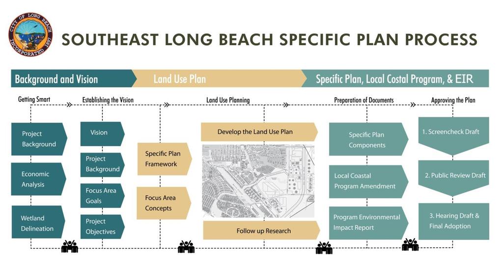
4 Process 4
5 City of Long Beach PROJECT OVERVIEW 5

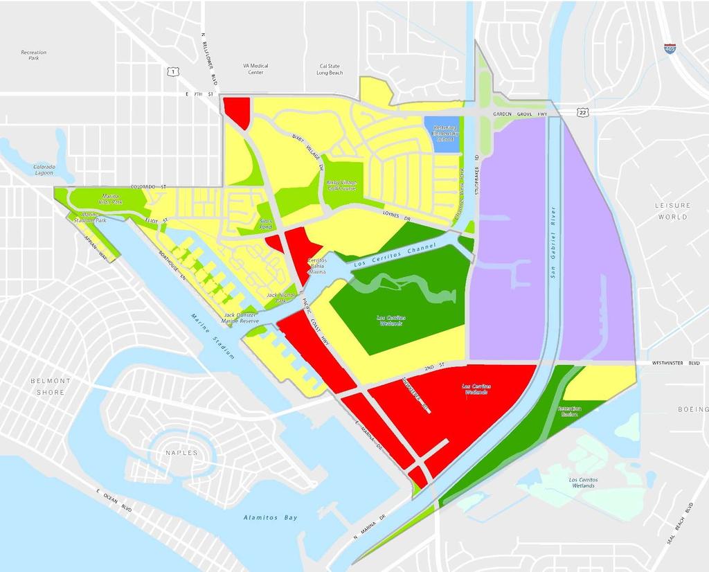
6 Project Area Boundaries 6
7 Vision City of Long Beach Southeast Long Beach is a livable, thriving and sustainable gateway destination in the City of Long Beach and the Southern California region. diversity of uses in close proximity residential neighborhoods businesses, restaurants, hospitality uses and recreational amenities locals and visitors connections significant social resources sense of community immediate impression current technologies thriving wetlands protect and encourage views restore, maintain and preserve wetland areas and coastal habitat attractive streetscapes bike lanes and pedestrian walkways efficient network of roadways attractive alternatives to the car variety in the appearance of the streetscape central gathering areas lively spaces transitions between urbanized areas and natural areas and waterways 7

8 Creating a Sustainable Plan Mobility Considerations Environmental Considerations Design Considerations Development Feasibility Analysis to understand whether new development can occur in current market conditions. Hotel, office, retail,residential Mixing of uses, product types, density Ways to fund new community amenities All areas must be considered equally to generate an implementable plan Sets the foundation for the Proposed Land Use Plan and zoning provisions 8
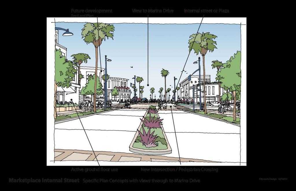
9 Differences between Existing and New Plan Proposes development of mid-rise uses (no high rise) No extension of Studebaker proposed in new plan Reflects ideas developed through feedback and discussion with public and Community Advisory Committee Creates comprehensive plan for entire SEADIP area; refines approach to existing development plan Emphasis on walkability, complete streets, new enhancements for bikes and pedestrians, creating new public space enhancements 9

")
10 Planned Land Uses (1977 SEADIP) 10

 Delineates Industrial areas and refines")
11 Proposed Land Uses (SEASP) Preserves established residential neighborhoods, neighborhood commercial uses, and open spaces Adds new Coastal Habitat, Wetland, & Recreation designation Adds new mixed-use designations (Mixeduse Marina; Mixeduse Community Core) Delineates Industrial areas and refines permitted uses 11
12 Proposed Land Use Designation Acres Dwelling Units Square Footage Estimated Population Channel/Marina/Waterway Coastal Habitat/Wetlands/Recreation ,000 - Commercial - Neighborhood 9-137,214 - Industrial 293-1,145,711 - Mixed Use (Community Core & Marina) 86 5,310 1,145,711 8,443 Mobile Homes Multi-Family Residential 117 2,458-3,908 Single Family Residential 187 1,440-2,290 Open Space/Recreation 75-4,670 - Public 20-51,301 - ROW/Caltrans OS Total 1,472 9,518 2,665,052 15,134 OTHER Existing Res and Non-Residential (Fire Station) Converting to Conventional Zoning ,
13 Project Description: SP Projections Dwelling units: 9,518 units Population: 15,134 persons Non-residential sq. ft. : 2,665,052 sq. ft. Commercial, office, industrial, public Hotel Rooms: 425 Employees: 4,115 Includes existing areas with no change as well as proposed refinements Totals do not include 9 acres of existing residential and fire station that will be removed from the SEADIP area and converted to traditional zoning 13
14 Differences between Existing and New Plan 59 acres originally designated for residential or commercial now designated as Coastal Habitat, Wetlands & Recreation Approximately 441,558 sq. ft. less of commercial uses than what is currently permitted in existing SEADIP (not including hotel sq. ft.) 4,019 more units and 6,391 more people than existing SEADIP 14

15 Connecting Wetlands to Water 15

16 View Corridors 16

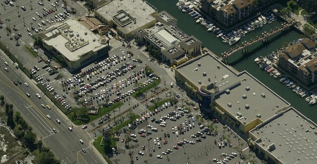
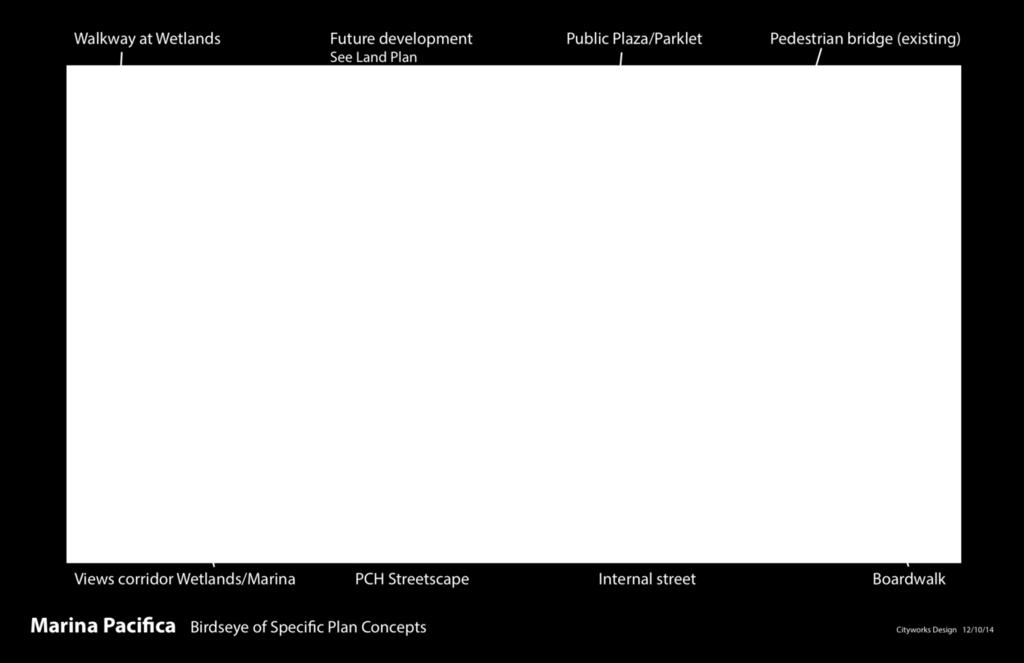
17 Waterway Promenade Waterway Promenade Specific Plan Concepts at Marina Pacifica City Works Design 03/
18 Biological Considerations Coastal Habitat, Wetlands & Recreation Use Coastal restoration, access Visitor serving uses (boating, public launching, kayaking) Interpretive centers Buffers Bird-safe Treatments Landscaping (non-invasive and native) Lighting Building materials 18


19 Urban Interface with Wetlands Active ground floor View overlooks Stepbacks 19
20 Mobility Considerations Priority: Improving circulation and providing enhanced opportunities for walking and biking as alternative to car Plan cannot solve congestion caused by regional traffic issues (cut through traffic that avoids congested freeways) Uses all of the tools available to mitigate that impact and improve local circulation (mid block connections, Shopkeeper extension, etc.) Improvements proposed within existing right-of-way widths New bike lane miles and new mid-block crossing added to plan to increase connectivity 20

21 Bicycle Network 21

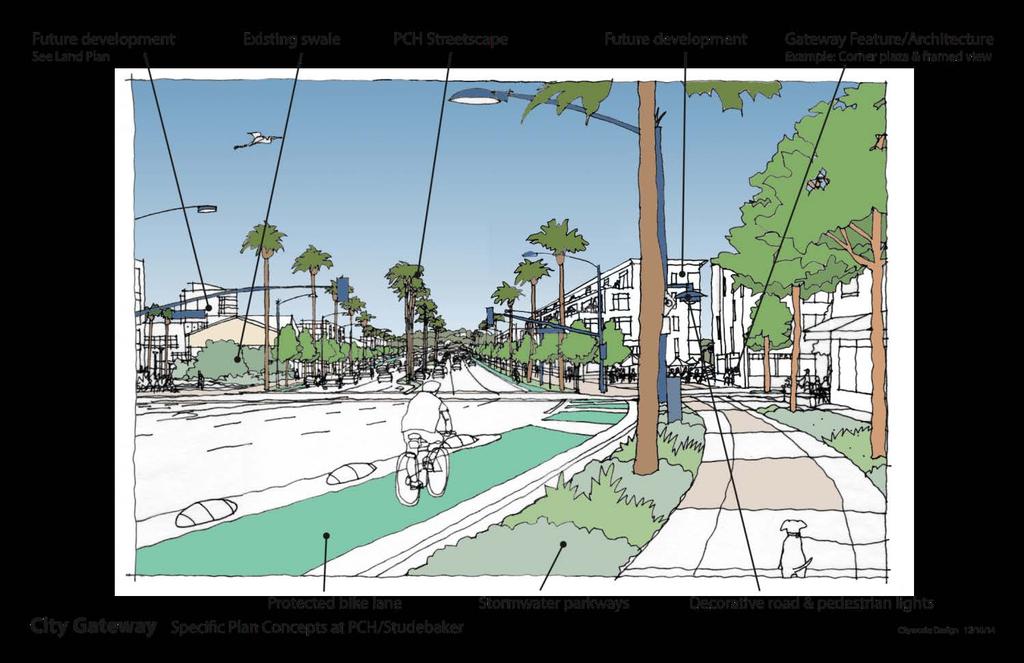
22 PCH Concept 22

23 Internal & Mid-Block Connectivity Example of an Internal Main Street Section New internal roadways and connections required in MU areas Internal roadways and connections provide new access for pedestrians, bikes and automobiles. 23
 or 29% increase in pedestrian facilities Existing = 23.6 directional miles Future = 30.")
24 Improved Mobility in SE Long Beach Bicycle Facilities About 7 additional miles of bike facilities (directional) or 79% increase in bicycle lane miles Existing = 8.9 directional miles Future = 15.9 directional miles Pedestrian Facilities About 6.9 additional miles of pedestrian facilities (directional) or 29% increase in pedestrian facilities Existing = 23.6 directional miles Future = 30.5 directional miles Automotive Facilities An increase in centerline miles by 1.9 or about 9% Existing = 22.2 centerline miles Future = 24.1 centerline miles Note: Estimates based on GIS Shapefiles 24
25 What the SEASP plan does for SELB Requests for new development would likely occur over time in the project area Without updated guidance of SP, uses would occur in same pattern as they have over past 30 years Big box and strip mall retail Large parking lots Circulation dependent upon auto access Comprehensive strategy (connectivity, placemaking, natural resources, new uses) Components of SP reflect values, aspirations and desired outcomes expressed throughout the process Represents best effort to balance community priorities 25

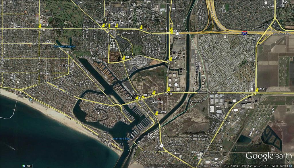
26 City of Long Beach ENVIRONMENTAL IMPACT REPORT 26
27 Purpose of CEQA California Environmental Quality Act (CEQA): Disclose project impacts to public and decision makers Identify ways to avoid or reduce environmental impacts (mitigation measures) Analyze alternatives to the proposed project Foster inter-agency coordination and review 27
28 Programmatic Analysis Program EIRs typically used for Specific Plans where no site specific development is proposed Different level of detail and method of analysis More conceptual and contain a more general discussion of impacts, alternatives, and mitigation measures than a Project EIR Establishes a path forward for evaluating future projects All environmental topical areas analyzed 28
29 Project Description. What is analyzed? Scope of Project Specific Plan buildout over existing, amendments to boundaries, land uses, infrastructure improvements Net increase of 5,439 dwelling units and 573,576 square feet of commercial/employment Must analyze maximum buildout Projects could come in at less intensity but CEQA requires an analysis of full buildout 29
30 Less than Significant Impacts Aesthetics Agriculture/Forestry Resources Geology/Soils Mineral Resources Population/Housing Public Services Recreation Utilities and Service Systems 30
31 Less Than Significant after Mitigation Biological Resources Cultural Resources (Archaeology, Paleontology, Tribal Cultural) Hazards and Hazardous Materials Hydrology/Water Quality 31
32 Significant and Unavoidable Impacts Air Quality Cultural Resources (Historical) Greenhouse Gas Emissions Noise (Construction) Transportation/Traffic 32
33 Air Quality Analyzed impact on local and regional air quality based on proposed land uses, VMT, and natural gas use (SCAQMD) Potentially significant impacts to all aspects of air quality Mitigation Measures Technical assessments and construction measures Project design features: EV charging, preference fuel efficient vehicles, energy star appliances Level of Significance: Significant and Unavoidable Mitigation measures will reduce impacts, but not below SCAQMD threshold. Potentially significant localized health effect during construction 33
34 Historical Resources Analyzed historical resources and historic (over 50 years old) structures. Potential impacts from redevelopment on or near an eligible resource that become eligible over life of plan or where retention, relocation is not feasible. Mitigation Measures Intensive level historical evaluation Level of Significance: Significant and Unavoidable 34
35 Greenhouse Gas Emissions Analyzed cumulative impact on GHG emission by evaluating transportation, energy, waste, water/wastewater, and etc. Potentially significant impacts due to increase in GHG emissions compared to existing conditions Mitigation Measures See AQ measures Level of Significance: Significant and Unavoidable Mitigation measures will reduce impact, but the City will not be able to meet the State established 2050 goal without additional state/federal assistance 35
36 Noise Analyzed short- and long-term impacts from noise and vibration sources Potentially significant impacts related to noise associated with construction, along with vibration associated with construction and industrial uses Mitigation Measures Implementation of BMPs, vibration impact study, compliance with FTA standards Level of Significance: Significant and Unavoidable Unknown number of future projects that may happen at once Possibility of special projects with higher intensity than a typical construction or proximity to sensitive uses 36
37 Transportation/Traffic Analyzed impact on transportation and traffic based on City s performance measures Existing conditions: Six intersections currently deficient Potentially significant impacts to 15 intersections during E+P and/or cumulative year, two freeway segments within SR-22, and two CMP intersections Mitigation Measures Traffic studies, signal timing, transportation impact fee, intersection improvements, employer trip demand management and reductions through formation of a transportation management association (TMA) Level of Significance: Significant and Unavoidable No feasible mitigation available to further reduce identified potential impacts due to related secondary impacts and jurisdictional issues 37
38 Alternatives Analyzed No Project/Adopted PD-1 (SEADIP) Alternative No Project/No Development Alternative Reduced Intensity Alternative Reduced Building Height Alternative Alternatives Buildout Statistical Summary Proposed Project No Project/ Adopted PD-1 (SEADIP) Alternative No Project/No Development Alternative Reduced Intensity Alternative Reduced Building Height Alternative Dwelling Units 9,518 5,499 4,079 6,663 9,518 Population 15,134 8,743 6,486 10,594 15,134 Commercial/ Employment Square Feet 2,665,05 2 3,106,610 2,091,476 2,398,547 2,665,052 Hotel Rooms Employment 4,115 5,280 3,555 3,704 4,115 38
39 Public Comment Currently accepting written comments on the DEIR Began on July 20, 2016 and ends on September 19, 2016 Recording Planning Commission Study Session Written comments on the DEIR should be mailed, faxed, or hand delivered to: Craig Chalfant, Senior Planner Development Services Department City of Long Beach 333 West Ocean Boulevard Long Beach, CA Facsimile: (562)
40 Next Steps Response to comments 60-day public review period closes on September 19th Response to Comments Future hearing dates November 3 rd : Planning Commission December 6 th : City Council Additional approvals required 2017: Coastal Commission submittal, review and hearings 40
41 SOUTHEAST AREA SPECIFIC PLAN Planning Commission Study Session August 18, 2016
42 Mobility Improvements Not Considered Freeway Improvements to SR-91, I-405, I-710, and SR-22 Many of these freeways congested for extended periods of time during the day More efficient for drivers to utilize Studebaker, Pacific Coast Highway, 7th Street, and/or 2nd Street to access areas surrounding the SEASP area (Belmont Shore, Downtown Long Beach, and Seal Beach) Improvements to these facilities would reduce congestion and potentially reduce traffic burden in the SEASP area (thus improving the travel time) Grade Separation at 2nd Street and Pacific Coast Highway Would dramatically improve travel time at this location however, would severely impact the ability to create place in the SEASP area and negatively affect bicycle and pedestrian travel in this area 42
43 Mobility Improvements Not Considered Improved east-west connectivity Any potential improvements to east-west connectivity or capacity in the City would improve operations and travel time in SEASP area (improvements to 7th Street, connecting Loynes to 3rd Street, improvements to Atherton Street, or any other improvements to reduce travel on 2nd Street) Many of these corridors lack available right of way or would negatively impact adjacent development along the corridor Extension of Studebaker Extension would significantly impact wetland areas (contrary to Vision) However, connection would relieve more traffic at the 2nd Street/Pacific Coast Highway intersection and improve operations at that location Extension of Ocean Boulevard to Ocean Avenue in Seal Beach New bridge to connect these two areas, likely significantly impacting residents in both areas and potential environmental impacts in the area. However, connection would provide a parallel facility to Pacific Coast Highway and would improve travel time in the SEASP area 43
44 Intersections 44
2035 General Plan Update and Belmont Village Specific Plan. Joint Study Session with the City Council and Planning Commission April 12, 2016
 2035 General Plan Update and Belmont Village Specific Plan Joint Study with the City Council and Planning Commission April 12, 2016 Agenda 1. Welcome and Introductions 2. General Plan Update Status of
SAN RAFAEL GENERAL PLAN 2040 INTRODUCTION AND OVERVIEW
 SAN RAFAEL GENERAL PLAN 2040 INTRODUCTION AND OVERVIEW Steering Committee Presentation February 14, 2018 Purpose of General Plan Guide land use and development decisions Coordinate transportation, infrastructure,
Planning Commission Report
 Planning Commission Report To: From: Subject: Planning Commission Meeting: January 6, 2016 Agenda Item: 8-B Planning Commission David Martin, Planning & Community Development Director Introduction to the
Transportation. Strategies for Action
 Transportation A major priority for the Overlake Neighborhood is to develop a multimodal transportation system. To achieve this system, a balance has to be found among travel, circulation and access needs;
A. WHAT IS A GENERAL PLAN?
 I. Introduction A. WHAT IS A GENERAL PLAN? A general plan is the planning guideline for the future of a city. It contains goals and policies which regulate urban development, the protection of the natural
Route 1 Corridor Study
 Route 1 Corridor Study Westbrook, Connecticut A Vision for the Connecticut Shoreline Public Informational Meeting July 28, 2015 Lower Connecticut River Valley Council of Governments Fitzgerald & Halliday,
ITEM #8. Regional Smart Growth Program. Regional Smart Growth Program. Presentation Overview. Coast Highway Vision and Stategic Plan.
 Regional Smart Growth Program Economic Development Commission What is Smart Growth? Adopted as part of the Regional Comprehensive Plan (RCP) RCP provides vision for region based on Smart Growth and sustainability
CITY OF ALHAMBRA DEVELOPMENT SERVICES DEPARTMENT 111 S. First Street. Alhambra, CA (626) FAX (626)
 FAX (626)") CITY OF ALHAMBRA DEVELOPMENT SERVICES DEPARTMENT 111 S. First Street. Alhambra, CA 91801 (626) 570-5030 - FAX (626) 458-4201 NOTICE OF PREPARATION TO: SUBJECT: Agencies, Organizations and Interested Parties
CITY OF ALHAMBRA DEVELOPMENT SERVICES DEPARTMENT 111 S. First Street. Alhambra, CA 91801 (626) 570-5030 - FAX (626) 458-4201 NOTICE OF PREPARATION TO: SUBJECT: Agencies, Organizations and Interested Parties
Secrest Short Cut and Monroe Expressway Small Area Plan AUGUST 29, 2018
 Secrest Short Cut and Monroe Expressway Small Area Plan AUGUST 29, 2018 Background and Process Monroe Expressway will be open by the end of 2018 Union County and Indian Trail identified a need to revisit
Introduction and Overview
 Introduction and Overview Articulate local values and priorities Guide land use and development decisions Coordinate transportation, infrastructure, and City services with expected growth and available
Urban Planning and Land Use
 Urban Planning and Land Use 701 North 7 th Street, Room 423 Phone: (913) 573-5750 Kansas City, Kansas 66101 Fax: (913) 573-5796 Email: planninginfo@wycokck.org www.wycokck.org/planning To: From: City Planning
Description of Preferred Alternative
 Chapter 2 Description of Preferred Alternative 2.1 Introduction This chapter of the programmatic Sammamish Town Center Sub-area Plan Final EIS provides a more detailed description of the Preferred Alternative
Gold Line Bus Rapid Transit Transit Oriented Development (BRTOD) Helmo Station Area Plan
 Helmo Station Area Plan") Appendix F Gold Line Bus Rapid Transit Transit Oriented Development (BRTOD) Helmo Station Area Plan Introduction and Purpose of the Plan The Gold Line Bus Rapid Transit facility is an eleven-mile dedicated
Appendix F Gold Line Bus Rapid Transit Transit Oriented Development (BRTOD) Helmo Station Area Plan Introduction and Purpose of the Plan The Gold Line Bus Rapid Transit facility is an eleven-mile dedicated
12/9/2013. HOLLYWOOD/PINES CORRIDOR PROJECT AMPO 2013 Annual Conference October 24, Our Perspective. Broward.
 HOLLYWOOD/PINES CORRIDOR PROJECT AMPO 2013 Annual Conference October 24, 2013 Our Perspective Broward Fort Lauderdale 1 Broward Metropolitan Planning Organization Fort Lauderdale Fort Lauderdale Skyline
PLAN ELEMENTS WORKSHOP. April 5, 2016
 PLAN ELEMENTS WORKSHOP April 5, 2016 needs more housing. But there is no one-size fits-all solution. Every neighborhood has its own character. In some places, density is not only appropriate it is badly
Issues Requiring Future Study
 Issues Requiring Future Study Transportation planning is an ongoing process that tends to identify new issues as it finds solutions for others. Some issues are so complex that a solution to one problem
TREASURE COAST REGIONAL PLANNING COUNCIL M E M O R A N D U M. To: Council Members AGENDA ITEM 5H
 TREASURE COAST REGIONAL PLANNING COUNCIL M E M O R A N D U M To: Council Members AGENDA ITEM 5H From: Date: Subject: Staff October 17, 2008 Council Meeting Local Government Comprehensive Plan Review Draft
Community Meeting #1: Project Kick Off
 Community Meeting #1: Project Kick Off November 17, 2015 What are 3 things you like about Downtown Gilroy that you want to hold onto in the future? Please write them down and share with us! Tonight s Meeting
COMMUNITY DEVELOPMENT SERVICES PLANNING AND BUILDING DEPARTMENT PLACERVILLE OFFICE:
 COMMUNITY DEVELOPMENT SERVICES PLANNING AND BUILDING DEPARTMENT http://www.edcgov.us/devservices/ PLACERVILLE OFFICE: LAKE TAHOE OFFICE: 2850 Fair Lane Court, Placerville, CA 95667 924 B Emerald Bay Rd.
CHAPTER 1. Ms. Guajardo s Class - Central Elementary CH 1 1
 INTRODUCTION CHAPTER 1 Ms. Guajardo s Class - Central Elementary CH 1 1 1.1 SETTING South Centre City is a linear corridor south of Downtown Escondido paralleling Centre City Parkway and South Escondido
3. Project Description
 3.1 PROJECT LOCATION The Platinum Triangle (herein after also referred to as the Project Area ) is located at the confluence of the Interstate 5 (I-5 Freeway) and the State Route 57 (SR-57 Freeway), in
CITY OF VACAVILLE PLANNING COMMISSION Agenda Item No. G.1 STAFF REPORT February 21, 2012 BRIGHTON LANDING SPECIFIC PLAN & DEVELOPMENT PROJECT
 CITY OF VACAVILLE PLANNING COMMISSION Agenda Item No. G.1 STAFF REPORT February 21, 2012 Staff Contact: Fred Buderi (707) 449-5307 TITLE: PURPOSE: BRIGHTON LANDING SPECIFIC PLAN & DEVELOPMENT PROJECT INFORMATIONAL
NOTICE OF PREPARATION OF AN ENVIRONMENTAL IMPACT REPORT AND SCOPING MEETING FOR THE WEST BROADWAY SPECIFIC PLAN COMMENT PERIOD
 DATE: July 11, 2018 TO: FROM: RE: Interested Persons Tom Buford, Principal Planner Community Development Department NOTICE OF PREPARATION OF AN ENVIRONMENTAL IMPACT REPORT AND SCOPING MEETING FOR THE WEST
EXISTING COMPREHENSIVE PLAN
 EXISTING COMPREHENSIVE PLAN Town Center Land Use Element: V. LAND USE POLICIES Town Center Mercer Island's business district vision as described in "Your Mercer Island Citizen-Designed Downtown" was an
Proposed Comprehensive Plan Strategies DRAFT for discussion June 28, 2017
 Proposed Comprehensive Plan Strategies DRAFT for discussion June 28, 2017 Land Use Rural Areas Refine the Farm and Forest area (FF) Update FF boundaries to account for existing lots less than five acres
4. ENVIRONMENTAL IMPACT ANALYSIS 7. LAND USE AND PLANNING
 4. ENVIRONMENTAL IMPACT ANALYSIS 7. LAND USE AND PLANNING 4.7.1 INTRODUCTION The following analysis discusses the consistency of the Proposed Project with the corresponding land use and zoning designations
ORANGE LINE TRANSIT NEIGHBORHOOD PLANS VAN NUYS NEIGHBORHOOD COUNCIL, PLUM COMMITTEE DEPARTMENT OF CITY PLANNING, CITY OF LOS ANGELES
 Photo: Mission Meridian(Moule & Polyzoides) ORANGE LINE TRANSIT NEIGHBORHOOD PLANS VAN NUYS NEIGHBORHOOD COUNCIL, PLUM COMMITTEE DEPARTMENT OF CITY PLANNING, CITY OF LOS ANGELES JULY 18, 2018 Project partially
CITY OF CHARLOTTESVILLE, VIRGINIA CITY COUNCIL AGENDA
 CITY OF CHARLOTTESVILLE, VIRGINIA CITY COUNCIL AGENDA Agenda Date: December 16, 2013 Action Required: Adoption of Resolution Presenter: Staff Contacts: Title: James E. Tolbert, AICP, Director of NDS James
Executive Summary. NY 7 / NY 2 Corridor
 Executive Summary NY 7 / NY 2 Corridor Transportation and Land Use Study December 2005 Prepared for: Town of Colonie Capital District Transportation Committee Prepared by: Introduction: Land use decisions
Chapter 1.0 Introduction
 Chapter 1.0 Introduction 1.1 Background The North Metro commuter rail line is part of the RTD FasTracks regional transit system expansion program to build more than 100 miles of rail transit throughout
NOTICE OF PREPARATION OF AN ENVIRONMENTAL IMPACT REPORT AND SCOPING MEETING FOR THE LAND PARK COMMERCIAL CENTER PROJECT
 NOTICE OF PREPARATION OF AN ENVIRONMENTAL IMPACT REPORT AND SCOPING MEETING FOR THE LAND PARK COMMERCIAL CENTER PROJECT PUBLIC COMMENT PERIOD November 12, 2015 to December 14, 2015 INTRODUCTION The City
Plan Overview. Manhattan Area 2035 Reflections and Progress. Chapter 1: Introduction. Background
 Plan Overview The Manhattan Urban Area Comprehensive Plan (the Comprehensive Plan) is a joint planning initiative of the City of Manhattan, Pottawatomie County, and Riley County. The 2014 Comprehensive
MAYFIELD WEST SECONDARY PLAN PHASE 2
 MAYFIELD WEST SECONDARY PLAN PHASE 2 Public Open House #3 February 25, 2010 Draft Preferred Land Use Scenario TOWN OF CALEDON PLANNING & DEVELOPMENT DEPARTMENT Open House Agenda TOWN OF CALEDON 1. Welcome
PINE CURVE REZONING. Property does not meet criteria for open space preservation and is not a candidate for a park
 PINE CURVE REZONING BACKGROUND Purchased as two parcels in 2001 and 2002 Annexed and Zoned Greater Downtown District Historic Center September 25, 2002 and October 7, 2002 WHAT THE PROJECT IS AND IS NOT
Public input has been an important part of the plan development process.
 Lakewood s Comprehensive Plan recognizes that transportation helps shape the community, and that the way the community provides for the safe and efficient movement of people affects the character of the
NOTICE OF PREPARATION
 NOTICE OF PREPARATION DATE: April 6, 2017 TO: FROM: Responsible Agencies Trustee Agencies Local and Public Agencies Interested Parties Contact: Brent Cooper, AICP, Community Development Director 4381 Broadway
Introduction. Chapter 1. Purpose of the Comprehensive Plan Plan Organization Planning Process & Community Input 1-1
 Chapter 1 Introduction Lakewood 2025: Moving Forward Together Purpose of the Comprehensive Plan Plan Organization Planning Process & Community Input 1-1 Purpose of the Comprehensive Plan The Comprehensive
CHAPTER 7: Transportation, Mobility and Circulation
 AGLE AREA COMMUNITY Plan CHAPTER 7 CHAPTER 7: Transportation, Mobility and Circulation Transportation, Mobility and Circulation The purpose of the Transportation, Mobility and Circulation Chapter is to
Draft Bergamot Area Plan
 ATTACHMENT 1 Draft Bergamot Area Plan Taskforce on the Environment April 15, 2013 www.bergamotplan.net 1 Overview WHAT IS THE BERGAMOT AREA PLAN? A Community-Based Planning Document Guiding the Future
DRAFT Land Use Chapter
 Stevens Creek Urban Village DRAFT 1 18 17 Land Use Chapter INTRODUCTION This Land Use Chapter describes how the Stevens Creek Urban Village will accommodate the growth that is planned for it in the Envision
3.10 LAND USE SETTING PROJECT SITE EXISTING LAND USE DESIGNATIONS AND ZONING. General Plan Land Use Designations.
 This section of the Draft EIR addresses the existing land uses on and adjacent to the project site and discusses the potential impacts of the proposed project on existing land uses. Key issues addressed
ELK GROVE GENERAL PLAN VISION
 2-1 CHAPTER 2: 2-2 CREATING OUR The Community Vision for Elk Grove, expressed through a Vision Statement and a series of Supporting Principles, is a declaration of the kind of community that Elk Grove
Scope of Services. River Oaks Boulevard (SH 183) Corridor Master Plan
 Corridor Master Plan") Scope of Services River Oaks Boulevard (SH 183) Corridor Master Plan PROJECT AREA The project area consists of the River Oaks Boulevard (SH 183) corridor bounded by SH 199 at the northern end and the Trinity
Scope of Services River Oaks Boulevard (SH 183) Corridor Master Plan PROJECT AREA The project area consists of the River Oaks Boulevard (SH 183) corridor bounded by SH 199 at the northern end and the Trinity
CITY OF PUYALLUP. Background. Development Services
 CITY OF PUYALLUP Development Services 333 South Meridian Puyallup WA 98371 To: City Council From: Katie Baker, AICP, Planning Division Re: South Hill Neighborhood Plan Adoption Date: (Meeting date: February
PG&E WINTERS GAS OPERATIONS AND TECHNICAL TRAINING CENTER
 PG&E WINTERS GAS OPERATIONS AND TECHNICAL TRAINING CENTER CEQA scoping Meeting March 19 th, 2014 Winters City Council Chambers - 6:30 pm AGENDA FOR THE MEETING 6:30 Welcome (John Donlevy) 6:40 Overview
South Davis County COMMUNITY SPOTLIGHT
 South Davis County COMMUNITY SPOTLIGHT Davis/SLC Community Connector Bus Rapid Transit line connecting SLC & Davis County RTP Phase 1 Project Generate 3,100 average weekday riders Relieve congestion on
Port Lavaca Future Land Use
 Port Lavaca Future Land Use Introduction The City of Port Lavaca is beginning to see sustained growth, after many years of relative stable population. New single family homes, apartments, and businesses
CITY OF SACRAMENTO GENERAL PLAN. UC Davis ESP 171 Urban and Regional Planning April 21, 2011
 CITY OF SACRAMENTO GENERAL PLAN UC Davis ESP 171 Urban and Regional Planning April 21, 2011 1 OUTLINE Background Growth and Change Placemaking Sustainability and Climate Change Economic Development 2 City
RESOLUTION NO. R Refining the route, profile and stations for the Downtown Redmond Link Extension
 RESOLUTION NO. R2018-32 Refining the route, profile and stations for the Downtown Redmond Link Extension MEETING: DATE: TYPE OF ACTION: STAFF CONTACT: Capital Committee Board PROPOSED ACTION 09/13/2018
St. Clair Avenue West Area Transportation Master Plan
 1 (Between Keele Street and Old Weston Road) Public Information Centre 1 December 2, 2015 2 Welcome Welcome to the first Public Information Centre for the St. Clair Avenue West Area. The panels will present
EXECUTIVE SUMMARY. Introduction
 EXECUTIVE SUMMARY Introduction State Route 68 is a designated scenic route that connects the world-renowned Monterey Peninsula to US Highway 101 and the Salinas Valley. SR 68 is a key route for bicycle,
Small Area Plan. South Gateway
 Small Area Plan Adopted May 12, 2008 South Gateway Purpose. The South Gateway Small Area Plan defines the City s expectations for the future of the southern entrance to the City at Interstate 85 and Highway
City of Farmington. Downtown Plan. Amendment to the 1998 Master Plan Adopted October 11, 2004
 City of Farmington Amendment to the 1998 Master Plan Adopted October 11, 2004 Introduction Planning Background 1 Scope and Components of the Plan Amendment 2 Concept Introduction 3 Plan Concepts 3 Conceptual
Silverdale Regional Center
 Silverdale Regional Center Vision for Silverdale Regional Center The Silverdale Regional Center Plan (Plan) will guide the evolution of the Silverdale Regional Center from a collection of strip malls and
Policies and Code Intent Sections Related to Town Center
 Policies and Code Intent Sections Related to Town Center The Town Center Vision is scattered throughout the Comprehensive Plan, development code and the 1994 Town Center Plan. What follows are sections
hermitage town center
 hermitage town center A Community Vision prepared by Strada for The City of Hermitage and The Mercer County Regional Planning Commission January 2007 table of contents introduction 3 design principles
Workshop. Valley Vision Stanislaus. Our Schedule. Help Shape Our Region s Future! The Scenarios. Who is StanCOG? How Do I Select a Scenario?
 Valley Vision Stanislaus Workshop Help Shape Our Region s Future! Valley Vision Stanislaus is a long-range planning process that will link future land use with a framework for investment in roads, freeways,
FDOT D4 Complete Streets
 FDOT D4 Complete Streets Context Sensitive Solutions Directs that complete street solutions will complement the context of the community. Collaborative approach to decision making, project development,
Promoting Economic Development Through Upfront SEPA Review: Lessons from South Downtown Tacoma
 Promoting Economic Development Through Upfront SEPA Review: Lessons from South Downtown Tacoma 1 This session will focus on the City of Tacoma s South Downtown Subarea Plan and associated Non-Project SEPA
The Five Components of the McLoughlin Area Plan
 The Five Components of the McLoughlin Area Plan This documents contains the complete language of the five components of the McLoughlin Area Plan: The Vision Statement The Values The Guiding Principles
TRANSPORTATION ELEMENT GOALS, OBJECTIVES, AND POLICIES
 TRANSPORTATION ELEMENT GOALS, OBJECTIVES, AND POLICIES GOAL 2 The City shall provide a safe, convenient, effective, and energy efficient multimodal transportation system which is coordinated with the Future
LAND USE ELEMENT. Purpose. General Goals & Policies
 LAND USE ELEMENT Purpose This Land Use Element contains the goals and policies necessary to support the City s responsibility for managing land resources and guiding development through implementing regulations,
Staff Report and Recommendation
 Community Planning and Development Planning Services 201 W. Colfax Ave., Dept. 205 Denver, CO 80202 p: 720.865.2915 f: 720.865.3052 www.denvergov.org/cpd TO: City Council Neighborhoods and Planning Committee
Town Center (part of the Comprehensive Plan)
") Town Center (part of the Comprehensive Plan) Mercer Island Town Center Looking North (2014) In 1994, a year-long process culminated in a set of design guidelines and code requirements for the Town Center
Town Center (part of the Comprehensive Plan) Mercer Island Town Center Looking North (2014) In 1994, a year-long process culminated in a set of design guidelines and code requirements for the Town Center
City of Royalton Comprehensive Land Use Plan 2005 to Revision February 8, 2011
 City of Royalton Comprehensive Land Use Plan 2005 to 2015 2011 Revision February 8, 2011 PART ONE: INTRODUCTION TO THE COMPREHENSIVE PLAN 1.0 Purpose and Introduction The Comprehensive Land Use Plan provides
WAC #7 3/14/14. Coachella General Plan Update
 WAC #7 3/14/14 Coachella General Plan Update Agenda 2 Introductions Public Draft General Plan Overview and Discussion of Next Steps Implementation and Evaluation Health Element Process Evaluation (discussion)
Status Report: MD 355 Project
 Status Report: MD 355 Project OCTOBER 2006 M-NCPPC MONTGOMERY COUNTY PLANNING DEPARTMENT Summary of Community Comments, and break to the Results of the MD 355 Participation Session Brookside Gardens -
Tyvola & Archdale Transit Station Area Plan. June 5, 2008
 Tyvola & Archdale Transit Station Area Plan Second Public Meeting June 5, 2008 Presentation Outline 1. Purpose and Process 2. Station Area Overview 3. Plan Recommendations 4. Comments Received and Proposed
Citizen Comment Staff Response Staff Recommended Revision Planning Committee
 Citizen Comment Staff Response Staff Recommended Revision Planning Committee Area No. 1: Owner desires retail land uses. Area No. 1a: Owner of two small parcels adjacent to Area No. 1 desires retail land
Broadway District Specific Plan. Community Workshop #2 February 23,2016
 Broadway District Specific Plan Community Workshop #2 February 23,2016 1 Agenda Introductions Project Progress Status Upcoming Milestones Emerging Framework Land Use Urban Design Circulation Infrastructure
Station Area Plan Introduction & Draft Alternatives Review
 Station Area Plan Introduction & Draft Alternatives Review City Council Meeting - February 22, 2016 Project Background: California High-Speed Rail San Jose to San Fernando Valley Segment CHSRA will select
GENERAL PLAN AND ENVIRONMENTAL IMPACT REPORT
 City of Menifee HEARING DRAFT GENERAL PLAN AND ENVIRONMENTAL IMPACT REPORT City Council November 2013 PURPOSE OF MEETING Overview of GP Process Overview of required and optional GP elements Receive direction
4/8/2015 Item #10D Page 1
 MEETING DATE: April 8, 2015 PREPARED BY: Christy Villa, Associate Civil Engineer DEPT. DIRECTOR: Glenn Pruim DEPARTMENT: Public Works CITY MANAGER: Larry Watt SUBJECT: NORTH COAST HIGHWAY 101 STREETSCAPE
Subregion 4 Central Avenue-Metro Blue Line Corridor Transit-Oriented Development (TOD) Implementation Project. Community Meeting April 27, 2011
 Implementation Project. Community Meeting April 27, 2011") Subregion 4 Central Avenue-Metro Blue Line Corridor Transit-Oriented Development (TOD) Implementation Project Community Meeting April 27, 2011 Overview Introduction to Subregion 4 TOD Implementation Program
Subregion 4 Central Avenue-Metro Blue Line Corridor Transit-Oriented Development (TOD) Implementation Project Community Meeting April 27, 2011 Overview Introduction to Subregion 4 TOD Implementation Program
California Environmental Quality Act (CEQA) Environmental Review Process
 Environmental Review Process") California Environmental Quality Act (CEQA) Environmental Review Process Los Angeles Union Station Forecourt and Esplanade Improvements constitute a Project Los Angeles County Metropolitan Transportation
California Environmental Quality Act (CEQA) Environmental Review Process Los Angeles Union Station Forecourt and Esplanade Improvements constitute a Project Los Angeles County Metropolitan Transportation
Public Open House. Overview of the Downtown Plan Official Plan Amendment April 23, 2018
 Public Open House Overview of the Downtown Plan Official Plan Amendment April 23, 2018 1 A 25-Year Plan for Downtown To ensure growth contributes positively to Toronto s Downtown as a great place to live,
DALY CITY VISIONING PROCESS COMMUNITY WORKSHOP 3 MAY 8, 2008
 DALY CITY VISIONING PROCESS COMMUNITY WORKSHOP 3 MAY 8, 2008 PROCESS General Plan - a statement of the community s values, vision and aspirations for now and into the future... Timeframe LONG TERM - 2030
West Kendall Corridor June 11, 2014
 June 11, 2014 Miami-Dade County Department of Regulatory and Economic Resources Development Services Division ā 1 Presentation Outline Review Study Area Review of Citizens Plans and Presentations Planning
SUBJECT: Waterfront Hotel Planning Study Update TO: Planning and Development Committee FROM: Department of City Building. Recommendation: Purpose:
 Page 1 of Report PB-23-18 SUBJECT: Waterfront Hotel Planning Study Update TO: Planning and Development Committee FROM: Department of City Building Report Number: PB-23-18 Wards Affected: 2 File Numbers:
THE GREEN VISION WORKSHOP Friday, November 6, 2009
 THE GREEN VISION WORKSHOP Friday, November 6, 2009 SUSTAINABLE LONG RANGE PLANNING IN SANTA MONICA Eileen Fogarty Director, Planning and Community Development GREEN BUILDINGS Santa Monica has the most
ARISE: The Rock Renaissance Area Redevelopment & Implementation Strategy
 2014 Professional Awards 1 ARISE: The Rock Renaissance Area Redevelopment & Implementation Strategy Janesville, WI Completed December 2014 Analysis & Planning Purpose of Project 2 The purpose of the Rock
Appendix A: Notice of Preparation and Responses
 City of American Canyon Broadway District Specific Plan Draft EIR Appendix A: Notice of Preparation and Responses FirstCarbon Solutions \\10.200.1.5\adec\Publications\Client (PN JN)\3148\31480009\EIR\2
Clair-Maltby Community visioning
 Clair-Maltby Community visioning workshop #1 Summary April 27th, 2017 Table of Contents INTRODUCTIon 1 PURPOSE 1 CONSULTATION STRUCTURE 2 PARTICIPANT FEEDBACK 3 VISIONING EXERCISE 8 ONLINE SURVEY RESULTS
1.0 Purpose of a Secondary Plan for the Masonville Transit Village
 Report to Planning and Environment Committee To: Chair and Members Planning & Environment Committee From: John M. Fleming Managing Director, Planning and City Planner Subject: Masonville Transit Village
Sheridan Boulevard S TAT I O N A R E A P L A N S H E R I D A N B O U L E VA R D S TAT I O N A R E A P L A N
 Sheridan Boulevard S TAT I O N A R E A P L A N 1 City of Lakewood Adopted November, 2006 S H E R I D A N B O U L E VA R D S TAT I O N A R E A P L A N The Vision The City of Lakewood s overall vision is
CITY COUNCIL AGENDA REPORT
 CITY COUNCIL AGENDA REPORT Subject: COUNCIL MOTION LRT ALIGNMENT REMOVAL FROM THE TRANSPORTATION MASTER PLAN On February 10, 2016 Councillor Hughes provided notice in accordance with Section 23 of Procedure
Jackson Highway Master Plans
 Jackson Highway Master Plans West Jackson Highway Master Plan (PLNP2008-00240) Jackson Township Specific Plan (PLNP2011-00095) NewBridge Specific Plan (PLNP2010-00081) Mather South Community Master Plan
Lehigh Acres Land Development Regulations Community Planning Project
 Lehigh Acres Land Development Regulations Planning Effort Summary In July, 2010 Commissioner Frank Mann invited the Lehigh Acres community to start discussing how to achieve their recently adopted community
SUBJECT: GO Station Mobility Hubs Preferred Concepts: Aldershot GO, Burlington GO and Appleby GO. Planning and Development Committee - Public Meeting
 Page 1 of Report PB-76-17 SUBJECT: GO Station Mobility Hubs Preferred Concepts: Aldershot GO, Burlington GO and Appleby GO TO: FROM: Planning and Development Committee - Public Meeting Planning and Building
Subarea 4 Indian Creek. Vision The combination of park networks and transportation amenities make Subarea 4 the greenest hub in the Corridor.
 indian creek 180 extends south from 101st Street to I-435. The I-435 and Metcalf intersection is one of the primary intersections in the Kansas City Metro Area. The area includes several residential neighborhoods
City of Tacoma Planning and Development Services
 Agenda Item E-1 City of Tacoma Planning and Development Services To: Planning Commission From: Elliott Barnett, Planning Services Division Subject: Tacoma Mall Regional Center Subarea Plan and EIS Meeting
Dwelling Units Max 12 dwelling units per acre/min 8 dwelling units per acre. Development Mix 80% non residential/20% residential
 13. OSTEEN LOCAL PLAN Background: The Osteen Local Plan area is located in southwest Volusia County along the SR 415 corridor between Lemon Bluff Road and Acorn Lake Road and includes 3,990 acres. The
Welcome to the Oakridge Centre Open House
 Welcome to the Oakridge Centre Open House Why is the City hosting this event? This open house is to inform you of a rezoning application submitted to the City of Vancouver to amend the existing CD-1 (Comprehensive
CENTRAL ESTUARY PLAN AVISION FOR OAKLAND S WATERFRONT
 Central Estuary Plan A VISION FOR OAKLAND S WATERFRONT Specific Plan and Environmental Assessment Presentation to the Parks and Recreation Advisory Commission December 9, 2009 This Afternoon s Presentation
Gratigny Parkway East Extension Project Development & Environment (PD&E) Study
 Study") Gratigny Parkway East Extension Project Development & Environment (PD&E) Study Session 4: Presentation of Charrette Results December 8, 2010 MDX Work Program #: 92407 ETDM#: 11500 Project Location & Description
Gratigny Parkway East Extension Project Development & Environment (PD&E) Study Session 4: Presentation of Charrette Results December 8, 2010 MDX Work Program #: 92407 ETDM#: 11500 Project Location & Description
PROCESS CHECK Implementing Ordinances planned for adoption with the General Plan:
 PROCESS CHECK PROCESS CHECK Implementing Ordinances planned for adoption with the General Plan: Urban Growth Boundary extension Northwest Quad zoning Bel Marin Keys Master Plan amendments (biotech campus,
Honorable Mayor and Members of the City Council. Submitted by: Eric Angstadt, Director, Planning and Development
 Office of the City Manager ACTION CALENDAR January 29, 2013 To: From: Honorable Mayor and Members of the City Council Christine Daniel, City Manager Submitted by: Eric Angstadt, Director, Planning and
LAND USE MODEL UPDATE. Planning and Land Use Advisory Committee Meeting #2 September 4, 2014
 1 LAND USE MODEL UPDATE Planning and Land Use Advisory Committee Meeting #2 September 4, 2014 2 Presentation Outline Introduction and Recap Model Process Study Design Place Types Suitability Factors 3
G. RECREATION AND OPEN SPACE ELEMENT. The following summarizes the Recreation and Open Space Element:
 G. RECREATION AND OPEN SPACE ELEMENT The purpose of the Element is to provide the framework and direction for a comprehensive system of public and private sites for recreation, including, but not limited
City Council Special Meeting AGENDA ITEM NO. C.
 City Council Special Meeting AGENDA ITEM NO. C. DATE: 01/04/2019 TO: Honorable Mayor and City Council Members SUBJECT: Transit Villages Specific Plan project Study Session (Development Services Director