PONTELAND NEIGHBOURHOOD PLAN LANDSCAPE QUALITY ASSESSMENT
|
|
|
- Virginia Lamb
- 5 years ago
- Views:
Transcription

1 PONTELAND NEIGHBOURHOOD PLAN LANDSCAPE QUALITY ASSESSMENT UPDATED CONSULTATION ISSUE NOVEMBER 2016
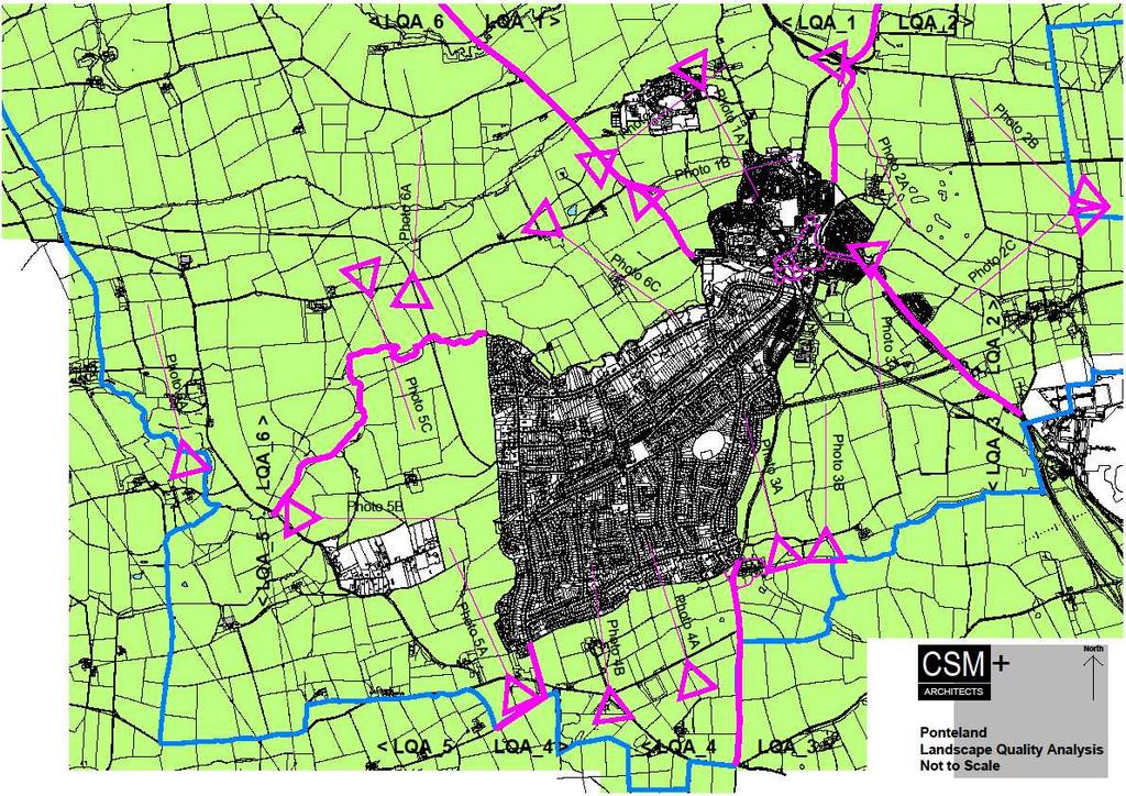
2 CONTENTS 2 Introduction 2 Methodology 4 Landscape Quality Areas Plan 5 Landscape Quality Area 1 SMALLBURN 6 Landscape Quality Area 2 PRESTWICK CARR 7 Landscape Quality Area 3 HIGH CALLERTON 8 Landscape Quality Area 4 BIRNEY HALL 9 Landscape Quality Area 5 MEDBURN 10 Landscape Quality Area 6 DISSINGTON ESTATE 11 Scoring Matrix 12 Sources 1
3 INTRODUCTION The Green Belt around Ponteland is under pressure for development both from speculative planning applications and Northumberland County Council's emerging Core Strategy which seeks to allocate land for housing This document was created under the stimulus of The Localism Act 2011 by Members of Ponteland Civic Society and other people who have an interest in the area and who care about its future. Its aim is to identify the contribution of the Green Belt towards national Green Belt purposes as set out in the National Planning Policy Framework (NPPF). This will identify both the primary functions of the Green Belt, which deliver the national purposes, and identify areas of Green Belt land which are considered to contribute least towards national purposes It also aims to show what makes each area special so that planning decisions are taken in context, and the character of the area as a whole can be maintained. It was first produced in September 2013 before Northumberland County Council prepared their Green Belt Review In 2014 it was checked against the Epping Forest methodology which was chosen as an example because if its similarities with Ponteland Parish. Epping Forest District is covered by roughly 92% Green Belt designation and has little available derelict and other urban land In 2015 it was updated again to take account of evidence given during the public enquiry following the appeal by Lugano Developments Ltd regarding land at Birney Hill Farm and the inspectors findings This final edition includes references to the emerging Ponteland Neighbourhood Plan and photographs taken in April 2016 THE GREEN BELT AROUND PONTELAND The village of Ponteland and most of Darras Hall sit in the valley between the River Pont and the Fairney Burn whilst most of the surrounding countryside is higher ground. This means that views into and out from the village are comparatively restricted and there is little or no intervisibility between the village and the Tyneside conurbation even though it is so nearby. The village itself quite unobtrusive so that there is a quite remarkable degree of landscape continuity, particularly in the unrestricted views across Ponteland from the south towards Simonside, The Cheviot, the border with Scotland and the Northumberland National Park The great majority of the land surrounding the village, is actively farmed (rather than being turned into pony paddocks for example) so that the landscape has a distinctly rural character. With the exception of the A696 Woolsington Bypass, the main routes to and from Ponteland also have a distinctly rural character. The A696 is tree lined on both the north and south approaches and the other routes are minor roads which twist and turn and have grass verges rather than paved footways; hedgerows rather than fences The Castle Morpeth District Local Plan identifies the banks of the River Pont throughout the Parish as an Area of High Landscape Value METHODOLOGY Six areas of land have been identified, each with a discernible character. A map illustrating this can be found on page 4 The area boundaries generally follow well defined physical features and the outer boundary of the study area is the Parish boundary generally and the Small Burn to the north They are each quite large areas which can seen from a single viewpoint as illustrated by the photographs. This is believed to reflect the essential characteristics of Green Belts which are their openness and their permanence 2
4 Green Belt areas are assessed against the first four national Green Belt purposes set out in the NPPF which are To check the unrestricted sprawl of large built-up areas To prevent neighbouring towns from merging into one another To assist in safeguarding the countryside from encroachment To preserve the setting and special character of historic towns The fifth NPPF purpose of the Green Belt which is to assist in urban regeneration, by encouraging the recycling of derelict and other urban land has not been considered as there is little available derelict and other urban land remaining in the Parish An overall value will be attributed to the contribution which each area makes towards Green Belt purposes. In some cases there may be particular parts of the area that perform differently to other parts of the area, a comment will be added where this is the case. There will be no weighting applied to the different purposes of the Green Belt as the NPPF does not prioritise the purposes The assessment will judge the value of the Green Belt on the basis of a high, medium or low level of contribution to Green Belt purpose. The results of the assessment are recorded in a matrix and mapped with a traffic light system 12 Questions to Assess Green Belt Areas against the National Purposes To Check the unrestricted sprawl of large built up areas 1. Would development of the area lead to, constitute or extend ribbon development? 2. Is the area well connected to a settlement? 3. Is there a strong, defensible boundary between the existing settlement and the site, for example a wall, watercourse, main road etc (as opposed to garden boundary lines), which if breached may set a precedent for unrestricted sprawl? To Prevent neighbouring towns from merging 4. Is the area free from natural features and infrastructure which might provide a good physical barrier or boundary to ensure that any development was contained? 5. Would development of the area lead to physical connection of 2 or more settlements? 6. Would development compromise the separation of settlements and the overall openness of the area visually? To Assist in safeguarding the countryside from encroachment 7. Does the area include national or local nature conservation designated areas (SSSIs etc)? 8. Does the area include areas of woodland, trees or hedgerows that are protected or significant unprotected tree/hedge cover? 9. Does the area include any grade 1 or grade 2 (excellent or very good quality) agricultural land? As all of the land around Ponteland is Grade 3 with the exception of Prestwick Carr, and indeed most of Northumberland, this question was changed to "Is the land actively farmed Preserve the setting and special character of historic towns 10. Is the site regarded as being sensitive to change 11. Is there a strong relationship, either physically or visually, to a conservation area, listed building or other historical features? 12. Is there a historic feature such as a Listed Building or Scheduled Monument within the site? 3
5 4


6 LANDSCAPE QUALITY AREA 1 PHOTOS SMALLBURN This area to the north of the village is defined by the A696 trunk road to the east and the River Pont to the west The slightly undulating landscape of the west bank of the river is broken by old field boundaries including lines of trees. Looking south, the settlement boundary edge is clearly visible against a backdrop of trees and rising ground beyond. The airport is concealed by rising ground to the east. Glimpses of the Simionside Hills and The Cheviot are possible to the north There are a number of listed buildings within the Police Headquarters site but they are contained within a proposed development The settlement boundary to the north of the village is clearly visible across the fields Beyond Berwick Hill Bridge, from the higher ground approaching Berwick Hill itself, the character of the area changes with the airport buildings seen across Prestwick Carr and the taller buildings of the Newcastle/Gateshead conurbation clearly visible on the skyline There are no footpaths across the area of land immediately south of the Police Headquarters, however it is clearly visible from the approach road to the headquarters and from the A696. The settlement boundaries at Thornhill Drive and Ladywell Way are clearly visible as a hard edge from both these roads The area to the east between Berwick Hill Road and the River Pont is of high landscape quality so provides a natural boundary and North Road provides a man made boundary dividing the remaining area. However there is no such feature between the village and the Police Headquarters. If development were permitted here a gap could be maintained albeit with some visual compromise A future revision of this document would treat the Pont Valley as a separate area to remove some of the compromises in the question values 1A_looking south east from the Police HQ 1B_looking south west from the A696 1C_looking towards the Police HQ from the A696 5
7 LANDSCAPE QUALITY AREA 2 PHOTOS PRESTWICK CARR This area to the east of the village is defined by the A696 trunk road and Newcastle International Airport to the east and the River Pont to the north. It comprises predominantly flat farmland falling gently from Cheviot View towards Prestwick Carr with isolated buildings in the landscape and Berwick Hill visible on the horizon to the north. The land becomes more undulating towards the River Pont in this area There is a huge sense of openness here and for that reason the site is regarded as being sensitive to change 2A_looking south west towards Cheviot View Prestwick Hall and Eland Hall are both listed buildings within the area and Prestwick Carr itself is a Site of Special Scientific Interest. The golf course surrounded by mature trees can be seen from most of the area The suburban edge of Cheviot View and Clickemin Farm are visible across fields to the south west. The sloping ground up towards High Callerton can be seen beyond and to the left of this. The Fairney Burn provides a natural barrier but the sloping land above this is prominent from Prestwick Carr and development between Cheviot View and Clickemin would extend the existing ribbon development along the skyline 2B_looking north west towards Berwick Hill 2C_looking south across the area from Berwick Hill Bridge 6

8 LANDSCAPE QUALITY AREA 3 PHOTOS HIGH CALLERTON This area to the south of the village and between the village and Darras Hall is defined by the A696 trunk road and Newcastle International Airport to the east and the Darras Hall Estate to the west. It contains the High Callerton Conservation area including a number of listed buildings The landscape is undulating farmland rising towards Callerton Common and dominated by Black Callerton Hill, Braid Hill and Brough Hill The wedge of open countryside north of Rotary Way separates the south east edge of Ponteland from Darras Hall. The old railway line cuts across this space and is a strong linear historic feature. Rotary Way also provides a man made barrier but is not visible from the higher ground. At Clickemnin bridge on the edge of the Ponteland Conservation Area, looking south, is one of only two views out of the village, in this case looking towards Callerton Common are visible against the Pont valley edge but the rest of the village is hidden from view in the valley with views towards Simonside and The Cheviot beyond The isolated Hold House Farm sits in the centre of the area The emerging Neighbourhood plan proposes a flood storage area between Rotary way and the old railway line which has the potential to create a site of nature conservation importance Development here would have the effect of bringing the village edge out of the River Pont Valley and potentially closing the gap between the houses on the approach to the village and Darras Hall 3A_looking south west from Clickemin Bridge 3B_looking south east from the lane towards Rotary Way The feathered edge (behind a strong tree line) of Darras Hall is visible to the west and suburban edge of Cheviot View to the east. Cheviot View is also visible from part of the Birney Hall package. The leisure Centre and School Buildings (which unfortunately have light coloured wall finishes) 3C_looking south west from the lane towards Rotary Way 7


9 LANDSCAPE QUALITY AREA 4 PHOTOS BIRNEY HALL This area to the south of Darras Hall is defined by Callerton Lane to the east and Western Way to the west. The land is open countryside, once parkland to Birney Hall, containing specimen trees and historic hedgerows and is known as Birney Hill It Contains the Grade II Listed Birney Hall, Birney Hill Farmhouse and two other listed structures questions 4. and 5. have been downgraded to red and orange respectively There is little or no street lighting. The night time landscape to the south of Ponteland is particularly dark and free of light pollution. The sense of landscape continuity is impressive and that reason contributes to the site being regarded as particularly sensitive to change 4A_looking north east from Birney Hill Lane The gradient is not consistent across the site. There is a shoulder coinciding with the 120m contour beyond which the land falls steeply towards the existing edge of the village so that only the rooflines of Darras Hall are visible. There are open views across the landscape to Simonside, The Cheviot, the border with Scotland and the Northumberland National Park 4B_looking north from Birney Hill Lane The shoulder is a natural feature which provides a strong boundary between the Darras Hall and the area. The inspector's report into the appeal by Lugano Developments Ltd regarding land at Birney Hill Farm noted that the ridge to the south of the Parish would prevent any development here from coalescing with the Tyneside Conurbation notwithstanding its close proximity. For that reason the values to 4C_looking north west from the drive to Birney Hall 8
10 LANDSCAPE QUALITY AREA 5 PHOTOS MEDBURN This area is defined by Western way to the east, the C345 "B" road to the west and the River Pont to the North. Farmland surrounds the village of Medburn which is mostly concealed by Heddon Law to the north, Farrick Hill to the south and a small raised area south of Eachwick to the west. The western boundary of the Darras Hall Estate is clearly visible within this area and Medburn itself when viewed from Farrick Hill has the appearance of a sizeable village Darras Hall) or extending south along the C345 road 5A_looking north from Woodhill Farm The isolated Donkins House Farm sits to the north of Medburn and a woodland, Benacres Plantation sits close to the River Pont to the north The linear settlement boundary to the south west of Darras Hall is clearly visible across the fields from Limestone Lane 5B_looking south across Medburn from Farrick Hill Notwithstanding the overall neutral value of this area it is difficult to see how additional development can be accommodated in Medburn without extending The Avenue (which would bring it even closer to the south west edge of 5C_ looking south from Limestone Lane 9

11 LANDSCAPE QUALITY AREA 6 PHOTOS DISSINGTON ESTATE This area is defined by the River Pont to the south and the Small Burn to the north. It comprises flat farmland falling gently south from Limestone Lane towards the River Pont with more undulating farmland between Limestone Lane and the Small Burn to the north Dissington Hall is a listed building within the area which also contains Forsters Plantation and Dissington Pond, both sites of nature conservation importance 1A_looking north towards Dissington Hall The area contains a number of small farmsteads The suburban edge of Darras Hall is visible across fields to the south behind the wooded valley of the River Pont. This is a key view which is important to the setting and approach to Ponteland on the A696 trunk road 1B_looking north from Limestone Lane 1C_looking south from Limestone Lane 10
12 SCORING MATRIX Score High Neutral Low Landscape Character Area Question Would development of the area lead to, constitute or extend ribbon development? 2 Is the area well connected to a settlement? Is there a strong, defensible boundary between the existing settlement and the site, for example a wall, watercourse, main road etc (as opposed to garden boundary lines), Is the area free from natural features and infrastructure which might provide a good physical barrier or boundary to ensure that any development was contained? Would development of the area lead to physical connection of 2 or more settlements? Would the development compromise the separation of settlements and the overall openness of the parcel visually? Does the area include national or local nature conservation designated areas (SSSIs etc)? Does the area include areas of woodland, trees or hedgerows that are protected or significant unprotected tree/hedge cover? Is the area actively farmed Is the site regarded as being sensitive to change Is there a strong relationship, either physically or visually, to a conservation area, listed building or other historical features? Is there a historic feature such as a Listed Building or Scheduled Monument within the site? 11
13 SOURCES National Planning Policy Framework, Department for Communities and Local Government 2012 Castle Morpeth District Local Plan, Northumberland County Council Key Land Use Impact Study, Northumberland County Council Land Use Consultants 2010 Northumberland Landscape Character Assessment, Northumberland County Council Land Use Consultants 2010 Green Belt Review Methodology, Epping Forest District Council 2014 Evidence by William Moses on behalf of the Ponteland Greenbelt Group Evidence by Tom Robinson on behalf of Northumberland County Council Land at Birney Hill Farm Appeal by Lugano Developments Ltd Public Inquiry January 2015 Agricultural Land Classification map North East Region (ALC001) Natural England ACKNOWLEDGEMENTS Ponteland Town Council Ponteland Civic Society Northumberland County Council CSM+Architects OS Copyright CSM+ or NCC 12
Toddington Central Bedfordshire Stage 3 Green Belt Study December 2017
 Toddington Central Bedfordshire Stage 3 Green Belt Study December 2017 Site: ALP086 - Middle Lakes, Toddington Site size (ha): 2.83 Site: ALP086 - Middle Lakes, Toddington Site size (ha): 2.83 Site description
Totternhoe Central Bedfordshire Stage 3 Green Belt Study December 2017
 Totternhoe Central Bedfordshire Stage 3 Green Belt Study December 2017 Site description The site is comprised of a single arable field on the southern side of the washed over settlement of Totternhoe.
Oxford Green Belt Study. Summary of Final Report Prepared by LUC October 2015
 Oxford Green Belt Study Summary of Final Report Prepared by LUC October 2015 Project Title: Oxford Green Belt Study Client: Oxfordshire County Council Version Date Version Details Prepared by Checked by
LEEDS SITE ALLOCATIONS PLAN MATTER 3 GREEN BELT KCS DEVELOPMENT AUGUST 2017
 LEEDS SITE ALLOCATIONS PLAN MATTER 3 GREEN BELT KCS DEVELOPMENT AUGUST 2017 Smith Limited Suite 9C Joseph s Well Hanover Walk Leeds LS3 1AB T: 0113 2431919 F: 0113 2422198 E: planning@peacockandsmith.co.uk
Warwickshire County Council. Upper and Lower Brailes. Landscape Study
 Warwickshire County Council Upper and Lower Brailes Landscape Study Produced by WCC Landscape Architects March 2016 Landscape Assessment of Potential Development Sites within the parish of Brailes 1.0
Settlement Boundaries Methodology North Northumberland Coast Neighbourhood Plan (August 2016)
") Introduction This background paper sets out a methodology for the definition of settlement boundaries in the North Northumberland Coast Neighbourhood Plan. The neighbourhood plan is planning positively
Introduction This background paper sets out a methodology for the definition of settlement boundaries in the North Northumberland Coast Neighbourhood Plan. The neighbourhood plan is planning positively
Neighbourhood Planning Local Green Spaces
 Neighbourhood Planning Local Green Spaces Introduction... 2 1. Why green space is important... 4 2. Neighbourhood plans and green space... 6 3. Evidence... 8 Statutory designations... 9 Green space audit...
Welford-on-Avon Neighbourhood Plan Consultation Event Sunday, 6 April Your name Your address
 Welford-on-Avon Neighbourhood Plan Consultation Event Sunday, 6 April 2014 Your name Your email address Please either: - complete this feedback form and put it in the box before leaving the Memorial Hall
The targets do not adhere to the government projections or methodology, being aspirational rather than achievable.
 Question 1: Preferred Growth Option (see pages 7-9 of the consultation document) Do you agree with the preferred growth option for the Joint Local Plan? The targets do not adhere to the government projections
The analysis of key visual characteristics and attributes that contribute to variations in the
 15.0 CHIGWELL/CHIGWELL ROW 15.1 Overview 15.1.1 Chigwell and Chigwell Row settlements are situated in the south of Epping Forest District, to the south of Abridge and southwest of Stapleford Abbotts. Both
And now... The KEY Arguments in. Greater Detail
 And now... The KEY Arguments in Greater Detail 'Exceptional Circumstances' Are Needed to Change the Green Belt EBC justification to build on Green Belt is based on: SHMA guestimate of housing needs for
There are two assessment methods used. The first is according to the criteria set out in the Neighbourhood Plan which are set out below.
 Background Paper 4 Site Assessments Context This background paper has been compiled to support the Gotham Neighbourhood Plan and is intended to document the viability of sites around Gotham with respect
Neighbourhood Planning Site Assessment Pro-forma and Guide Version 2
 Neighbourhood Planning Site Assessment Pro-forma and Guide Version 2 September 2014 Site HNP 006 Land East of Stanbridge Road and North of Lower Road 1. Background information Site location and use Site
Natural Environment, Open Spaces & Habitats Subgroup
 Natural Environment, Open Spaces & Habitats Subgroup 1. Background, Settlement Context and Vision 1.1 Ponteland in the Twentieth Century 1.2 Parish Profile 1.3 Town Council Civil Parish Map and Ward Boundaries
Mid Coquetdale Neighbourhood Plan - Vision and Objectives Consultation
 Neighbourhood Planning came into force in 2011, through the Localism Bill. It gives us a unique opportunity to produce our own Neighbourhood Development Plan for our own area. Rothbury Parish Council,
Droitwich Spa 6. Reasoned Justification
 87 Droitwich Spa 6 Reasoned Justification 6.1 Droitwich Spa is identified in the settlement hierarchy (Policy SWDP1) as a main town being the largest settlement in Wychavon District with an estimated population
WELCOME. Land west of Great Canfield Road, Takeley. Welcome. Have your say. Pegasus Urban Design
 01 WELCOME Welcome Gladman Developments Ltd have successfully invested in communities throughout the UK over the past 20 years, developing high quality and sustainable residential, commercial and industrial
INTRODUCTION. Land south of Bishopswood Lane, Tadley
 0 INTRODUCTION THE SITE Introduction Gladman Developments Ltd. has successfully invested in communities throughout the UK over the past 0 years, developing high quality and sustainable residential, commercial
an Inspector appointed by the Secretary of State for Communities and Local Government
 Appeal Decision Site visit made on 6 November 2017 by Rachel Walmsley BSc MSc MA MRTPI an Inspector appointed by the Secretary of State for Communities and Local Government Decision date: 19 th January
Copyright Nigel Deeley and licensed for reuse under this Creative Commons Licence
 1 Copyright Nigel Deeley and licensed for reuse under this Creative Commons Licence Prepared by the Neighbourhood Plan Steering Group on behalf of Garway Parish Council with assistance from 2 Table of
SITE ALLOCATION PLAN FEEDBACK HG2-10 Gill Lane, Formerly Site 1221
 SITE ALLOCATION PLAN FEEDBACK HG2-10 Gill Lane, Formerly Site 1221 My Response Nigel Wilson Chairman, Nether Yeadon Conservation Area 24 Gill Lane Nether Yeadon, LS19 7DD NTWILSON@OUTLOOK.COM I wish to
GUILDFORD BOROUGH GREEN BELT AND COUNTRYSIDE STUDY
 GUILDFORD BOROUGH GREEN BELT AND COUNTRYSIDE STUDY Volume II - Addendum On behalf of Guildford Borough Council PPG Ref : BNL.0287 April 2014 COPYRIGHT The conents of this document must not be copied or
2015/1020 Mr Edward Cockburn Caravan storage on hardcore base (Retrospective) Ranah Stones, Whams Road, Hazlehead, Sheffield, S36 4HT
 Ranah Stones, Whams Road, Hazlehead, Sheffield, S36 4HT") 2015/1020 Mr Edward Cockburn Caravan storage on hardcore base (Retrospective) Ranah Stones, Whams Road, Hazlehead, Sheffield, S36 4HT Dunford Parish Council have not commented Councillor Andrew Millner
2015/1020 Mr Edward Cockburn Caravan storage on hardcore base (Retrospective) Ranah Stones, Whams Road, Hazlehead, Sheffield, S36 4HT Dunford Parish Council have not commented Councillor Andrew Millner
Proposed Sheffield City Region Combined Green Belt Review A Common Approach August 2014
 Proposed Sheffield City Region Combined Green Belt Review A Common Approach August 2014 1.1 Purpose To achieve the principles of Duty to Cooperate, it is beneficial for all Local Authorities within the
North Hertfordshire Green Belt Review
 North Hertfordshire Green Belt Review July 2016 North Hertfordshire Local Plan 2011-2031 Evidence Base Report 2 Contents 1. Background and Approach to the Review. PART ONE: ASSESSMENT OF THE CURRENT GREEN
Public Consultation 23 January Peel Hall, Warrington Board 1. A message from Satnam... Site history...
 Board 1 A message from Satnam... Thank you for attending today s public consultation about proposals to develop a new residential neighbourhood at. The display boards show why the development is needed
Central Bedfordshire and Luton Green Belt Study Appendix 1
 Central Bedfordshire Council www.centralbedfordshire.gov.uk Central Bedfordshire and Luton Green Belt Study Appendix 1 July 2017-1 - Appendix 1 Stage 1 assessments Central Bedfordshire and Luton Green
DUNSFOLD NEIGHBOURHOOD PLAN Site Selection Policies
 DUNSFOLD NEIGHBOURHOOD PLAN Site Selection Policies The criteria for assessing sites for future housing and business development in Dunsfold are set out below. (Development criteria, covering what it is
By to: 30 March Thank you for the opportunity to respond to this important consultation.
 70 Cowcross Street London EC1M 6EJ Tel: 0207 253 0300 Fax: 0207 490 3001 office@cprelondon.org.uk www.cprelondon.org.uk Environment, Housing & Regeneration London Borough of Sutton 24 Denmark Road Carshalton
Planning and Regulatory Committee 20 May Applicant Local Councillor Purpose of Report
 Planning and Regulatory Committee 20 May 2014 7. APPLICATION FOR PLANNING PERMISSION FOR THE CARRYING-OUT OF DEVELOPMENT PURSUANT TO PLANNING PERMISSION REFERENCE NUMBER 603451 DATED 28 FEBRUARY 2007 WITHOUT
National Character Area 70 Melbourne Parklands
 Summary The are a landscape of rolling farmland, parkland and woodland on the northern flanks of the ridge between Burton upon Trent and Swadlincote. The land slopes down to the River Trent, which borders
Environmental and Landscape Mapping
 Environmental and Landscape Mapping In support of the Calveley Neighbourhood Plan November 2016 Project Name and Number: Calveley Neighbourhood Plan 16-025 Document Name and Revision: Environmental and
Blandford Forum Town Council, Blandford St Mary Parish Council and Bryanston Parish Council
 Blandford Forum Town Council, Blandford St Mary Parish Council and Bryanston Parish Council Blandford + Neighbourhood Plan 2 Pre-Submission Plan Consultation (November 2018) Representations submitted on
ENVIRONMENTAL AND LANDSCAPE MAPPING
 APPENDIX IV : Environmental and Landscape Mapping ENVIRONMENTAL AND LANDSCAPE MAPPING Calveley Neighbourhood Plan November 2016 ENVIRONMENTAL AND LANDSCAPE MAPPING Calveley Neighbourhood Plan Calveley
Environment Agency Flood Risk Map for the Village of Bridge
 Environment Agency Flood Risk Map for the Village of Bridge December 2016 21 Objective F. Conserving and Enhancing the Natural Environment The National Planning Policy Framework states that the planning
Viewpoint 1. Location: View from Murch Road on the north eastern boundary of Application Site. Viewing south / southwest.
 Application Site (eastern field) Former site of St. Cyres Lower School Murch Road 1 Location: View from Murch Road on the north eastern boundary of Application Site. Viewing south / southwest. Baseline
Site Assessment Technical Document Appendix A: Glossary
 Central Bedfordshire Council www.centralbedfordshire.gov.uk Site Assessment Technical Document Appendix A: Glossary July 2017 1.1.11-1 - ii Appendix A: Glossary Term Agricultural Land Classification AONB
Northumberland Key Land Use Impact Study PART B. Proposed Extension of the Green Belt Around Morpeth
 Northumberland Key Land Use Impact Study PART B Proposed Extension of the Green Belt Around Morpeth 1. INTRODUCTION 1.1. The study brief requires that an assessment is carried out of the landscape qualities
SPG 1. * the northern and western sections which are open fields used for pasture and grazing;
 SPG 1 1.0 INTRODUCTION This development brief is based on the allocation of the Priors Hall site for employment and countryside recreational purposes in the Corby Borough Local Plan. The brief is intended
Neighbourhood Plan Representation
 Date: 10 th November 2017 Neighbourhood Plan Representation Land to the east of Callow Hill Road, Alvechurch Introduction This representation has been prepared by RPS Planning and Development on behalf
Longhorsley Neighbourhood Plan
 Site Assessment 1. The availability of the site 1.1 Is the land owner willing for their site to be made available for development? 1.2 If yes, do you have any written evidence to back this up? Planning
East Harptree Landscape & Character Assessment
 East Harptree Landscape & Character Assessment Produced by East Harptree Parish Council in consultation with local residents September 2014 Contents The Parish of East Harptree: Objective Introduction
1.0 INTRODUCTION. Brantham Industrial Area Regeneration - Factory Lane - Brantham
 1.0 INTRODUCTION Welcome to this exhibition of our proposals for the regeneration of the Brantham Industrial Area located off Factory Lane in Brantham. This presentation will give you an opportunity to
Introduction. Grounds of Objection
 Planning application ref. number 18/04496/APP Planning application to Aylesbury Vale District Council for the erection of 17 dwellings and associated works to the South of Hogshaw Road Granborough. Granborough
Evesham 7. Reasoned Justification
 95 Reasoned Justification 7.1 Evesham is situated within the Vale of Evesham and has an estimated population of 22,800 (2009 Mid-Term Population Estimates). As a main town it provides a wide range of services
Public Consultation. Land at Monks Farm, North Grove. Welcome
 Welcome Welcome to our public exhibition for development on Land at Monks Farm, orth Grove. Gallagher Estates and Gleeson Strategic Land are preparing an outline planning application for new homes, open
Statement of Community Involvement LAND OFF SOUTHDOWN ROAD HORNDEAN, HAMPSHIRE
 LAND OFF SOUTHDOWN ROAD HORNDEAN, HAMPSHIRE CONTENTS Page 1. Introduction 3 2. Pre-application Discussions 4 3. The Consultation Process 5 4. Consultation Feedback 7 5. Responses to Consultation Feedback
SITE ASSESSMENTS. September 2018 SOUTHWATER PARISH COUNCIL BEESON HOUSE, 26 LINTOT SQUARE, SOUTHWATER, RH13 9LA
 September 2018 SITE ASSESSMENTS PREPARED TO ASSIST THE PREPERATION OF THE SOUTHWATER NEIGHBOURHOOD PLAN SOUTHWATER PARISH COUNCIL BEESON HOUSE, 26 LINTOT SQUARE, SOUTHWATER, RH13 9LA INTRODUCTION TABLE
Landscape Assessment CEUGP/SR9B
 Landscape Assessment CEUGP/SR9B TABLE OF CONTENTS 1 STUDY PHILOSOPHY... 3 2 GENERAL DESCRIPTION OF SITE... 4 3 LANDSCAPE THEMES... 8 TABLE OF FIGURES Table 1: Landscape... 5 Table 2: Landscape Themes...
ROCHFORD LOCAL DEVELOPMENT FRAMEWORK: Sustainability Appraisal/ Strategic Environmental Assessment. Rochford Core Strategy Preferred Options Document
 ROCHFORD LOCAL DEVELOPMENT FRAMEWORK: Sustainability Appraisal/ Strategic Environmental Assessment Non Technical Summary Rochford Core Strategy Preferred Options Document October 2008 SUSTAINABILITY APPRAISAL
Rudy Parish Neighbourhood Plan Steering Group Meeting 6/8/2018. Proposed Green Spaces (Continued from SG meeting of 2/7/18)
") Rudy Parish Neighbourhood Plan Steering Group Meeting 6/8/2018 Proposed Green Spaces (Continued from SG meeting of 2/7/18) NPPF: Green Space Designation The Local Green Space designation will not be appropriate
Rudy Parish Neighbourhood Plan Steering Group Meeting 6/8/2018 Proposed Green Spaces (Continued from SG meeting of 2/7/18) NPPF: Green Space Designation The Local Green Space designation will not be appropriate
APPENDIX 4. 5 ST AGNES LOCAL LANDSCAPE CHARACTER ASSESSMENT TABLE ST AGNES BEACON
 APPENDIX 4. 5 ST AGNES LOCAL LANDSCAPE CHARACTER ASSESSMENT TABLE ST AGNES BEACON CHARACTER AREA: ST AGNES BEACON DATE OF ASSESSMENT May 2016 Character Attribute Landscape reference guide ST AGNES BEACON
Application and Proposals. Part 211
 Application and Proposals Part 211 Site Location and Context The application site comprises two distinct land parcels totalling some 135 hectares. The site is bisected eastwest by Churchlands Development.
viii Figure ES1: Recommended changes to Green Belt boundaries in Waverley
 viii Figure ES1: Recommended changes to Green Belt boundaries in Waverley 50 3.4 Elstead (segments W5, W11, W18, W19) 3.4.1 Area of search 51 3.4.2 Assessment against Green Belt criteria Segment W5: land
Name: Former Ornamental Garden and Trees at 1 Harestone Drive. Site is Grounds of 1 Harestone Drive formerly the Marie Curie Hospice.
 Name: Former Ornamental Garden and Trees at 1 Harestone Drive Location: Site is Grounds of 1 Harestone Drive formerly the Marie Curie Hospice. No.48 Coloured Red on plan. Description. Former site of Harestone
PLANNING COMMITTEE DATE: 07/09/2015 REPORT OF THE SENIOR MANAGER PLANNING AND ENVIRONMENT SERVICE CAERNARFON. Number: 4
 Number: 4 Application Number: C15/0034/37/LL Date Registered: 21/05/2015 Application Type: Full - Planning Community: Llanaelhaearn Ward: Llanaelhaearn Proposal: Location: Summary of the Recommendation:
Conservation Area Designation, amendments and Review
 Conservation Area Designation, amendments and Review Location: No.s 37-49 (odd) Twickenham Road Date Assessed: January 2018 Adjacent Conservation Area Significance: Teddington Lock CA. The Teddington Lock
Illustrative Visual Impression DISSINGTON GARDEN VILLAGE
 Illustrative Visual Impression DISSINGTON GARDEN VILLAGE DELIVERING DISSINGTON GARDEN VILLAGE The purpose of this booklet is to share with you our proposals for Dissington Garden Village. Please let us
PDP DESIGN & ACCESS STATEMENT
 PDP The Planning & Design Partnership Planning.. Architecture.. Interiors.. Landscape The Chicory Barn Studio, The Old Brickyards, Moor Lane, Stamford Bridge York, The East Riding Of Yorkshire, YO41 1HU.
APP/G1630/W/15/
 Appeal Decision Site visit made on 20 October 2015 by William Fieldhouse BA (Hons) MA MRTPI an Inspector appointed by the Secretary of State for Communities and Local Government Decision date: 20 November
EAST OF ENGLAND OFFICE
 Mr Philip Isbell Direct Dial: 01223 582751 Mid Suffolk District Council 131 high Street Our ref: P00524468 Needham Market Ipswich Suffolk IP6 8DL 18 January 2017 Dear Mr Isbell T&CP (Development Management
Rochford District Council Allocations Development Plan Document: Discussion and Consultation Document Sustainability Appraisal
 Option SWH1 Balanced Communities Option SWH1 1 To ensure the delivery of high quality sustainable communities where people want to live and work Will it ensure the phasing of infrastructure, including
INTRODUCTION. Land off Main Road, Great Leighs. Introduction
 01 INTRODUCTION Introduction Gladman Developments Ltd have successfully invested in communities throughout the UK over the past 20 years, developing high quality and sustainable residential scheme. We
INTRODUCTION. Land off Beresford Road, Holt. Introduction. Site Description. Housing Need. Why is the site suitable for development?
 01 INTRODUCTION Introduction Thank you for taking the time to view this public exhibition and find out more about Gladman Development s latest proposals to develop a new sustainable community of up to
ASSESSMENT OF LOCAL GAPS IN BREDON PARISH
 ASSESSMENT OF LOCAL GAPS IN BREDON PARISH Revised May 2016 1. Introduction 1.1 Bredon Parish Council has set out to identify s along the connecting roads between settlements in the parish, which either
Neighbourhood Planning Guidance Local Green Spaces
 Neighbourhood Planning Guidance Local Green Spaces Introduction This guidance note has been produced for communities preparing neighbourhood plans in North Dorset to help them to identify, assess and designate
SITE ASSESSMENT CHECKLIST
 1. Site Details a. What is the site s name/reference? SITE ASSESSMENT CHECKLIST CR3NPWHY 3007 Gasometer Site Godstone Road CR3 0EG b. Where is the site located? Wyhteleafe; Godstone Road. Urban category1
Representation to East Lothian Council Local Development Plan, Main Issues Report
 Representation to East Lothian Council Local Development Plan, Main Issues Report CALA Management Ltd - In respect of land at Pinkie Mains Farm, Inveresk Question 11: Musselburgh Cluster The Site The site
Welcome. Land adjacent Sandy Lane WALTHAM CHASE THE PROPOSED SITE
 Land adjacent Sandy Lane WALTHAM CHASE Existing Linden Homes developments Welcome Welcome to Linden Homes Southern s ( Linden ) public exhibition about its proposals for a range of high-quality homes for
Development in the setting of the Cotswolds AONB
 COTSWOLDS CONSERVATION BOARD POSITION STATEMENT Development in the setting of the Cotswolds AONB.1. Introduction Areas of Outstanding Natural Beauty (AONBs) are designated by the Government for the purpose
LONGDEN VILLAGE DEVELOPMENT STATEMENT
 LONGDEN VILLAGE DEVELOPMENT STATEMENT 2017-2027 1 Longden Development Statement 2017-2027 15/01/18 1. Background 1.1 Longden Village Longden village is a very rural and traditional community first mentioned
GREEN BELT ASSESSMENT OF HOLLANDS FARM, BOURNE END AND SURROUNDING AREA
 27 November 2017 SHF/AC P17-1325 KBEG OF HOLLANDS FARM, BOURNE END AND SURROUNDING AREA PREPARED ON BEHALF OF KEEP BOURNE END GREEN (KBEG) Prepared by: SARAH HAMILTON FOYN BSc (Hons) Dip TP MRTPI ANDREW
Site ref: AS06 Site Name or Address: Murreys Court, Agates Lane
 Site ref: AS06 Site Name or Address: Murreys Court, Agates Lane Proposed Land Use: Total Site Area (Ha): Housing 1.85 Ha Description: It is understood that the owner has no plans to dispose of the site
Salhouse Parish Council, 11 th November Response to Planning Application
 Salhouse Parish Council, 11 th November 2013 Response to Planning Application 20131408 Summary Salhouse Parish Council (SPC) has received via Broadland District Council a Planning Application for a 5MWp
Effingham Neighbourhood Plan 1. Basic Conditions Statement
 Effingham Neighbourhood Plan 1 Basic Conditions Statement Effingham Neighbourhood Plan 2016: Basic Conditions Statement 2 Contents This statement has been prepared by Effingham Parish Council to accompany
Copyright Nigel Deeley and licensed for reuse under this Creative Commons Licence
 1 Copyright Nigel Deeley and licensed for reuse under this Creative Commons Licence Prepared by the Neighbourhood Plan Steering Group on behalf of Garway Parish Council with assistance from 2 Table of
Table of Allocated Housing Sites
 Draft as of 0 November 016 Table of Allocated Housing s Name Green 1 (30, 33, 10, 169, 36/ 100) Barratt s Farm Balsall Common Yes 57 800 Includes existing park. Listed buildings to edge of site. of search
Great Easton Sustainable Housing Development Sites - Site Seven, Broadgate extension site SHLAA Ref HSG/03)
") Great Easton Sustainable Housing Development Sites - Site Seven, Broadgate extension site SHLAA Ref HSG/03) 1. Introduction The Great Easton Neighbourhood Plan Group are preparing a Neighbourhood Plan
Great Easton Sustainable Housing Development Sites - Site Seven, Broadgate extension site SHLAA Ref HSG/03) 1. Introduction The Great Easton Neighbourhood Plan Group are preparing a Neighbourhood Plan
SOUTH CAMBRIDGESHIRE DISTRICT COUNCIL. Planning and New Communities Director
 SOUTH CAMBRIDGESHIRE DISTRICT COUNCIL REPORT TO: Planning Committee 9 January 2013 AUTHOR/S: Planning and New Communities Director S/2270/12/FL FEN DRAYTON 850m long flood defence embankment ranging in
SODC LOCAL PLAN 2032 SECOND PREFERRED OPTIONS RESPONSE
 From: Chris Neil MBE, Chair Clifton Hampden and Burcot Parish Council To: SODC Planning by email: planning@southandvale.gov.uk CC: Sue Lawson, District Councillor 22 May 2017 SODC LOCAL PLAN 2032 SECOND
The Case for a South Hampshire Green Belt. January 2018
 The Case for a South Hampshire Green Belt January 2018 CPRE Hampshire s Vision For A Green Belt South Hampshire is a growth area. A consequence of this is the need for more employment, and more housing.
Kibworth Harcourt. Introduction. Introduction
 Introduction Introduction Welcome to this public exhibition on the proposals for the delivery of new homes on land at The Kibworths. The purpose of today s exhibition is to give you the opportunity to
SITE ASSESSMENT FORM
 Appendix 2 SITE ASSESSMENT FORM 1. Site information Settlement: Colwall Main Village Site name: SITE 1 Part of vacated Colwall school site and adjacent area Site address: Walwyn Road Site area (hectares):
HOROWHENUA DEVELOPMENT PLAN June create a safe crossing for children moving to and from the school and other areas. 7.8 Ohau
 7.8 Ohau create a safe crossing for children moving to and from the school and other areas. Ohau has a traditional village form with a collective of school, church and reserve at the main road intersection.
DRAFT STRATEGIC ENVIRONMENTAL ASSESSMENT REPORT
 DRAFT STRATEGIC ENVIRONMENTAL ASSESSMENT REPORT Published by Limpsfield Parish Council in accordance with EU Directive 2001/42 on Strategic Environmental Assessment and with the Environmental Assessment
Great Hammerton Growth Area: Our Vision August Hammerton Growth Area Harrogate: Our Vision
 Great Hammerton Growth Area: Our Vision August 2015 Hammerton Growth Area Harrogate: Our Vision i Contents 1.0 Introduction 1 2.0 Our Vision 3 3.0 Principle of Development 5 4.0 Site Context 7 5.0 Townscape
ENVIRONMENTAL INVENTORY
 Hungarton Neighbourhood Plan ENVIRONMENTAL INVENTORY Sites scoring 25/36 or more (70%) are judged to be the most important environmental and community sites and are proposed as Local Green Space. Other
RULE 6 (6) STATEMENT OF CASE
 STATEMENT OF CASE") RULE 6 (6) STATEMENT OF CASE Former Allerthorpe Park Golf Club, Allerthorpe, YO42 4RL Submitted on Behalf of Allerthorpe Parish Council Appeal by Turnwalk Ltd. and Park Leisure 2000 Ltd. Appeal Reference:
RULE 6 (6) STATEMENT OF CASE Former Allerthorpe Park Golf Club, Allerthorpe, YO42 4RL Submitted on Behalf of Allerthorpe Parish Council Appeal by Turnwalk Ltd. and Park Leisure 2000 Ltd. Appeal Reference:
LOGGERHEADS NEIGHBOURHOOD PLAN LOCAL GREEN SPACE DESIGNATION OCTOBER 2016
 DRAFT LOGGERHEADS NEIGHBOURHOOD PLAN LOCAL GREEN SPACE DESIGNATION OCTOBER 2016 1. Introduction For many local communities, green infrastructure in and around their neighbourhood is an important issue,
Conservation Area Designation, amendments and Review
 Conservation Area Designation, amendments and Review Location: Any area largely confined to Park Road and St. James Avenue which includes the following properties: St. James Church, St. James Road; No.
Appendix B Figures L1 and L2 - Townscape Analysis
 The Derriford Transport Scheme WEBTag Townscape and Visual Impact Appraisal (WTVA) Appendix B Figures L1 and L2 - Townscape Analysis J:\29210 Plymouth City Modelling\Technical\Landscape\Reports\29210_De
New Homes at Winton East
 View toward Winton East from Caerketton Hill Aerial photograph of South Edinburgh: Winton East Site Location Indicative proposal Welcome Thank you for coming to the Winton East public exhibition. We would
Bradleys Both Parish Council
 Bradleys Both Parish Council Bradleys Both Housing Site Assessments April 2015 Contents 1.0 Introduction... 2 2.0 BR001 Health Lea and Land to Rear, Skipton Road... 2 3.0 BR002 Holly Tree House and Land
Experiences of dealing with Lesser Horseshoe Bats (Rhinolophus
 Experiences of dealing with Lesser Horseshoe Bats (Rhinolophus hipposideros) in Wales, UK Len Wyatt Environmental Science Advisor, Transport, Housing and Strategic Regeneration, Welsh Assembly Government,
CLOUGHJORDAN SETTLEMENT PLAN
 CLOUGHJORDAN SETTLEMENT PLAN 1.0 General Introduction and Development Context Location The market town of Cloughjordan lies close to the border with Offaly at the junction of the R490 and R491 Regional
Draft Hailey Neighbourhood Plan
 Persimmon Homes (Wessex) Draft Hailey Neighbourhood Plan Representations to West Oxfordshire District Council s Regulation 16 Consultation December 2018 2 Copyright 2018 Persimmon Homes Ltd. All rights
September A new neighbourhood at Kemsing Station. Concept Masterplan
 September 2018 A new neighbourhood at Kemsing Station Concept Masterplan 1 Kemsing Station Neighbourhood - Key Benefi ts Transport Hub Extra parking, station improvements and links across the district
8.0 Design and Form of Development 43/
 42/ 8.0 Design and Form of Development 43/ Rothwells Farm, Golborne/ Development Statement Figure 7. Site Constraints Key 44/ Site Boundary 360 Bus Route/Stops Existing Trees Underground Water Pipe Sensitive
WELCOME. Olney Road, Lavendon INTRODUCTION. The Site. The Application. The Need for Housing. A Sustainable Location LAVENDON TURVEY OLNEY ROAD
 0 WELCOME INTRODUCTION Gladman Developments Ltd have successfully invested in communities throughout the UK over the past 0 years, developing high quality and sustainable residential, commercial and industrial
Parish of Repton NEIGHBOURHOOD DEVELOPMENT PLAN
 Parish of Repton NEIGHBOURHOOD DEVELOPMENT PLAN BASIC CONDITIONS STATEMENT December 2018 CEF 4 Legal Requirements This statement has been produced by the NDP Working Group on behalf of Repton Parish Council