Lake Macquarie City. A copy of the published amendment including the instrument and maps, is provided in Attachment 7 of this report.
|
|
|
- Thomasine McKinney
- 5 years ago
- Views:
Transcription
1 Planning Proposal Amendment No. 77 to Lake Macquarie Local Environmental Plan 2004 and proposed Amendment to Draft Lake Macquarie Local Environmental Plan 2013 Minor Zone Boundary Adjustment - Pasminco 13A Main Road, Boolaroo Local Government Area: Lake Macquarie City Name of Draft LEP: Lake Macquarie Local Environmental Plan 2004 (Amendment No. 77) and Draft Amendment 13A Main Road, Boolaroo to Draft Lake Macquarie Local Environmental Plan Subject Land: Part 13A Main Road, Boolaroo - Part of Lot 2 DP Owner: Applicant: Maps and Photos: Pasminco Cockle Creek Smelter Pty Ltd (subject to a deed of company arrangement) Ferrier Hodgson on behalf of Pasminco Cockle Creek Smelter Pty Ltd (subject to a deed of company arrangement) Attachment 1 Locality Map Attachment 2 Aerial Photo Attachment 3 Current Zoning - Lake Macquarie LEP 2004 Attachment 4 Zoning Draft Lake Macquarie LEP 2013 Attachment 5 Draft Amendment No. 77 to Lake Macquarie LEP 2004 Attachment 6 Proposed Zoning Draft Lake Macquarie LEP 2013 Attachment 7 Amendment No. 77 to Lake Macquarie LEP 2004 Final Instrument and Map Amendment No. 77 to the LMLEP 2004 was published on 6 September The Amendment rezoned part of the site from Zone 2(2) Residential (Urban Living) and B4 Mixed Use zone to 3(2) Urban Centre (Support) zone. The amendment also rezoned sections of land from 3(2) Urban Centre (Support) zone to 2(2) Residential (Urban Living). A copy of the published amendment including the instrument and maps, is provided in Attachment 7 of this report. The Planning Proposal below explains how and why the LEP Amendment was made. Part 1 Objective of the Planning Proposal The objective of the planning proposal is to make minor zone boundary adjustments on the former Pasminco site at Boolaroo to ensure the zone boundaries match lot
2 and road boundaries. The zone boundary adjustments are required because of changes to the location and alignment of the roundabout and Munibung Road extension due to detailed design. Part 2 Explanation of the Provisions The amendment proposes the following changes to Lake Macquarie LEP 2004: Amendment Applies To Map Dictionary Explanation of the Provision The planning proposal will rezone: small sections of land from 2(2) Residential (Urban Living) and B4 Mixed Use zone to 3(2) Urban Centre (Support) zone. The amendment will rezone approximately 5,114m 2 of 2(2) Residential (Urban Living) and B4 Mixed Use zoned land. small sections of land from 3(2) Urban Centre (Support) zone to 2(2) Residential (Urban Living). The amendment will rezone approximately 513m 2 of 3(2) Urban Centre (Support) zoned land. Amend the definition of the map by adding Lake Macquarie Local Environmental Plan 2004 (Amendment No 77) The Planning Proposal would result in the following changes to Draft Lake Macquarie LEP 2013 (Council s Standard Instrument LEP): Amendment Applies To LMLEP 2013 Standard Instrument Land Zoning Map (LNZ_011) LMLEP 2013 Standard Instrument Minimum Lot Size Map (LSZ_011) LMLEP 2013 Standard Instrument Building Height Map (HOB_011) Explanation of the Provision Amend the land zoning map to rezone: small sections of land from R3 Medium Density Residential zone to B4 Mixed Use zone. small sections of land from B4 Mixed Use zone to R3 Medium Density Residential zone. Minimum lot sizes would correspond to proposed zoning as follows: R3 450m 2. No minimum lot size is proposed for the B4 Mixed Use zone. Maximum building heights would correspond to proposed zoning as follows: R3 10m and B4 13m. Part 3 Justification for the Provisions A. Need for the planning proposal 1. Is the planning proposal a result of any strategic study or report?
3 The planning proposal is not the result of a strategic study or report. The former Pasminco Cockle Creek Smelter site at Boolaroo was rezoned in two stages in 2010 and 2011 respectively. The former Pasminco site was rezoned from its 4(1) Industrial (General) zone to a mixture of residential, employment and conservation zones. Since the rezoning of the former Pasminco Cockle Creek Smelter site, detailed subdivision and road design has occurred on the proposed extension of Munibung Road. The detailed road design for Munibung Road has resulted in a lot and road boundary that does not align with the zone boundary as the intersection type has changed from a proposed signalised intersection to a roundabout. The LEP amendment is consistent with the original intention for Munibung Road to form the boundary between residential and employment zones. This amendment is also needed to avoid issues with the assessment and determination of future development applications. 2. Is the planning proposal the best means of achieving the objectives or intended outcomes, or is there a better way? It is considered that the planning proposal is the only way to achieve the intended outcome, which is to make minor zone boundary adjustments to ensure the zone boundaries match lot and road boundaries due to the change in road alignment for Munibung Road and the change of intersection design. B. Relationship to strategic planning framework 3. Is the planning proposal consistent with the objectives and actions contained within the applicable regional or sub-regional strategy (including the Sydney Metropolitan Strategy and exhibited draft strategies)? The Lower Hunter Regional Strategy identifies the site as employment land given its previous industrial use. The proposal is for a minor zone boundary adjustment, however will facilitate employment uses which will assist fulfilling the employment targets of the Lower Hunter Regional Strategy. 4. Is the planning proposal consistent with the local council s Community Strategic plan, or other local strategic plan? Lifestyle 2030 Strategy Council s Lifestyle 2030 identifies the following for Pasminco: The redevelopment of the former Pasminco Cockle Creek Smelter site will also provide an opportunity for large scale urban redevelopment. The redevelopment of the Pasminco site will provide additional employment land. The former Pasminco site falls within the growth and expansion corridor, which is located generally between Cardiff and West Wallsend on George Booth Drive.
4 The zone adjustment is considered consistent with the Lifestyle 2030 Strategy as it will allow for the redevelopment of the Pasminco site and adjust the zone boundaries to be consistent with the proposed road boundaries. 5. Is the planning proposal consistent with applicable state environmental planning policies? An assessment has been undertaken to determine the level of consistency the proposal has with relevant State Environmental Planning Policies (SEPPs). The assessment is provided below. SEPPs Relevance Implications SEPP 19 Bushland in Urban Areas SEPP 44 Koala Habitat Protection SEPP 55 Remediation of Land Aims to prioritise the conservation of bushland in urban areas, and requires consideration of aims in preparing a draft amendment Aims to encourage the proper conservation and management of areas of natural vegetation that provide koala habitat. Aims to establish planning controls and provisions for the remediation of contaminated land The subject land does not contain any vegetation recognised as urban bushland as the site is devoid of vegetation due to previous industrial and remediation activities. No koala habitat or potential koala habitat has been identified on the sites. The site has previously been used for the former Pasminco Cockle Creek Lead Smelter. The site was given remediation approval on 27 February 2007 under Part 3A of the Environmental Planning and Assessment Act 1979 and has been in the process of remediation. The former Pasminco site is being remediated in stages. The areas subject to this amendment are nearing the completion stage of remediation works. Areas subject to this planning proposal will not be developed until remediation is complete and a Site Audit Statement is issued stating that the site has been remediated to allow the intended residential and business
5 SEPPs Relevance Implications uses. SEPP (Infrastructure) 2007 SEPP 71 Coastal Protection Aims to provide a consistent planning regime for the delivery of infrastructure. It also provides provision for consultation and assessment. This SEPP ensures that development in the NSW coastal zone is appropriate and suitably located, to ensure that there is a consistent and strategic approach to coastal planning and management. Development resulting from the proposal can be adequately serviced with existing infrastructure. The site is within the Coastal Zone as defined on the Coastal Zone Maps for Lake Macquarie. The site does not have direct access to the foreshore and is only marginally visible from Lake Macquarie. The rezoning will not affect the beach environment or coastal management strategies. The proposal is only a small zone boundary alignment and the proposal is consistent with this SEPP. 6. Is the planning proposal consistent with applicable Ministerial Directions (s.117 directions)? The proposal has been assessed against relevant Ministerial Directions. The assessment is provided below. The proposal is considered consistent with most section 117 Directions, however there is a minor inconsistency with Direction 1.1 Business and Industrial Zones and Direction 3.1 Residential Zones as small areas of employment land will be rezoned to residential and small areas of residential land will be rezoned to employment uses. The proposed amendment is very minor in nature and will not impact on the employment or housing capacity of the site. The Director General of the DoPI in the Gateway determination gave concurrence that these were minor inconsistencies and no further approvals are required. Ministerial Direction Business and Industrial Zones Relevance Aims to encourage employment growth in suitable locations, protect employment land in Implications The proposal seeks to rezone small sections of residential land to employment. In this regard,
6 Ministerial Direction 1.3 Mining, Petroleum Production and Extractive Industries 2.2 Coastal Protection 2.3 Heritage Conservation Relevance business and industrial zones, and support the viability of identified strategic centres. Aims to ensure that the future extraction of State or regionally significant reserves of coal, other minerals, petroleum and extractive materials are not compromised by inappropriate development. This direction aims to implement the principles in the NSW Coastal Policy. Aims to conserve items of environmental heritage by requiring a draft LEP to include provisions to facilitate the protection and Implications the proposal is consistent with this direction as the boundary adjustment will result is a slight increase to allow employment generating uses with a proposal for a Hardware store on the site. The proposal also seeks to rezone a small area of employment land to residential. In this regard, the proposal is inconsistent with this direction, which states that a planning proposal must not reduce the total potential floor space area for employment uses in business zones. However the amendment is very minor in size and will not impact on the employment capacity of the site. The NSW Department of Primary Industries (Minerals) and Mine Subsidence Board (MSB) previously advised in the past rezoning application for the former Pasminco site that they had no objection to the rezoning providing underground mining is permissible with development consent. The land lies within the coastal zone and this direction applies. The amendment is a minor zone boundary adjustment and will not have any impacts on the coastal zone. The site adjoins the heritage items of the Former Laboratory Building (BR16), as well as heritage items RT - 02 Speers Point
7 Ministerial Direction 3.1 Residential Zones 3.4 Integrating Land Use and Transport Relevance conservation of Aboriginal and European heritage items. The direction requires a draft LEP to include provisions that facilitate housing choice, efficient use of infrastructure, and reduce land consumption on the urban fringe. The aim of this direction is to ensure that urban structures, building forms, land use locations, development designs, subdivision and street layouts achieve the following planning objectives: (a) improving access to housing, jobs and services by walking, cycling and public transport, and (b) increasing the choice of available transport and reducing dependence on cars, and (c) reducing travel demand including the number of trips generated by development and the distances travelled, especially by car, and (d) supporting the efficient and viable operation of Implications Steam Tram Line and RT- 03 Great Northern Railway. However, the proposal does not affect land on which these items are located and the proposal is consistent with this direction. The development design will need to consider the significance of these heritage items. The rezoning proposal seeks to rezone some medium density residential land to an employment zone to ensure the zone boundaries align with the lot boundaries due to a changed road alignment. In this regard, the proposal is inconsistent with this direction. However, the zone change is minor, involves a very small area of land, and will not reduce the dwelling yield for the area. The proposal seeks to rezone small sections of land to ensure zone and lot boundaries are consistent. The location is directly opposite the Cockle Creek train station and the site is well serviced in terms of public transport by rail and bus. The proposal is consistent with this direction as it will provide employment opportunities with good access to public transport.
8 Ministerial Direction 4.1- Acid sulphate Soils Relevance public transport services, and (e) providing for the efficient movement of freight. Aim to avoid significant adverse environmental impacts from the use of land that has a probability of containing acid sulphate soils. Implications Part of the subject land has the potential for Class 5 Acid Sulphate Soil. Class 5 Acid Sulphate Soils are defined as works within 500 metres of adjacent Class 1,2,3,or 4 land, which are likely to lower the watertable below one metre AHD on adjacent Class 1,2,3 or 4 land. The planning proposal is a minor zone boundary adjustment and is considered of minor significance that will not increase the likelihood of exposing potential acid sulphate soils. 4.2 Mine Subsidence and Unstable Land 4.3- Flood prone land Aims to ensure development is appropriate for the potential level of subsidence. The direction requires consultation with the Mine Subsidence Board where a draft LEP is proposed for land within a mine subsidence district. Aims to ensure that development of flood prone land is consistent with the NSW Government Flood Prone Land Policy and the Principles of the Floodplain Development Manual 2005, and to ensure that the provision of an LEP on flood prone land is commensurate The site is within a proclaimed Mine Subsidence district pursuant to section 15 of the Mine Subsidence Compensation Act Consultation has occurred with the Mine Subsidence Board (MSB) and no objections were raised. The MSB approval would be required for any subdivision or the erection of improvements subsequent to the rezoning. The site is not flood prone. The proposal is consistent with this direction.
9 Ministerial Direction 5.1 Implementation of Regional Strategies 6.1 Approval and Referral Requirements 6.3 Site Specific Provisions Relevance with flood hazard and includes consideration of the potential flood impacts both on and off the subject land. Aims to give legal effect to regional strategies, by requiring draft LEPs to be consistent with relevant strategies. The direction requires a draft amendment to be consistent with the relevant State strategy that applies to the Local Government Area. Prevents a draft LEP from requiring concurrence from, or referral to, the Minister or a public authority unless approval is obtained from the Minister and public authority concerned. Also restricts the ability of a Council to identify development as designated development without the Director General s agreement. Aims to reduce restrictive site specific planning controls where a draft LEP amends another environmental planning instrument in order to allow a particular development proposal to proceed. Draft LEPs are encouraged to use existing zones rather than have site specific exceptions. Implications This direction requires a proposal to be consistent with the Lower Hunter Regional Strategy. The proposal is considered consistent with this direction as it will facilitate employment growth in the region. The draft amendment does not require concurrence from, or referral to, the Minister or a public authority. The planning proposal is consistent with this direction. The amendment does not propose any site specific zones or planning provisions. The proposal is consistent with this direction. C. Environmental, social and economic impact 7. Is there any likelihood that critical habitat or threatened species, populations or ecological communities, or their habitats, will be adversely affected as a result of the proposal? The site has a long history of previous use for heavy industrial purposes. The site has been subject to recent remediation, which has included the removal of vegetation on the site and the removal of contaminated soil to facilitate
10 remediation. Given the disturbance to the site, there is unlikely to be any threatened species, populations or ecological communities on the site. 8. Are there any other likely environmental effects as a result of the planning proposal and how are they proposed to be managed? The former Pasminco site was previously contaminated with heavy metals. Remediation approval was issued on 27 February 2007 under Part 3A of the Environmental Planning and Assessment Act 1979 and remediation works have occurred on the site. The former Pasminco site is being remediated in stages. The areas subject to this amendment are nearing the completion stage of remediation works. Areas subject to this planning proposal will not be developed until remediation is complete and a Site Audit Statement is issued stating that the site has been remediated to allow the intended residential and business uses in accordance with the Part 3A approval and the Contaminated Land Management Act There are no other likely environmental effects as a result of the planning proposal as the proposal is a minor zone boundary adjustment and the site has previously been heavily disturbed and remediated. 9. How has the planning proposal adequately addressed any social and economic effects? The planning proposal is a minor zone boundary adjustment, however positive economic impacts are envisaged when the site is ultimately developed. The amendment will ensure that Munibung Road acts to separate the employment and residential areas. Future development will need to ensure that any scenic and noise impacts from employment generating activities are minimised on nearby residential areas. Council s current Pasminco Area Plan contains provisions to ensure these impacts are considered. Further assessment of the social and economic impacts will occur at development application stage. D. State and Commonwealth interests 10. Is there adequate public infrastructure for the planning proposal? The site is well serviced in terms of access to public infrastructure. The site is serviced with access to Main Road, Boolaroo and in the future will be accessible from the proposed extended Munibung Road. The site is opposite Cockle Creek train station. The site is serviced by all relevant utility infrastructure including water, sewer, electricity and telecommunications. 11. What are the views of State and Commonwealth public authorities consulted in accordance with the gateway determination? Consultation has occurred with the Roads and Maritime Service (RMS) and the Mine Subsidence Board (MSB) in line with the Gateway determination. The RMS raised no objections or issues with the planning proposal.
11 The Mine Subsidence Board raised no objection to the planning proposal and advised that the applicant should be advised to seek the Board s approval for the subdivision or the erection of improvements.

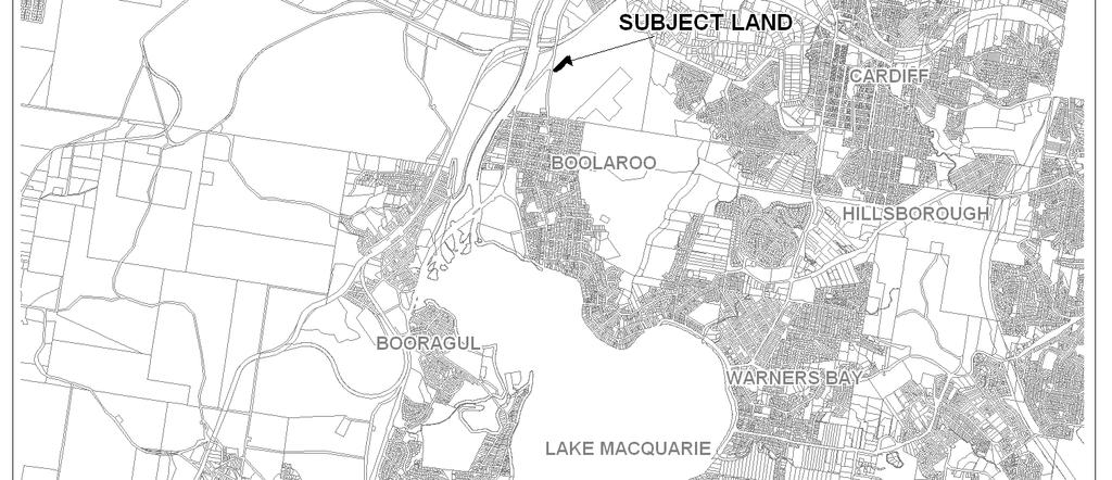
12 Part 4 - Mapping Attachment 1- Locality Map
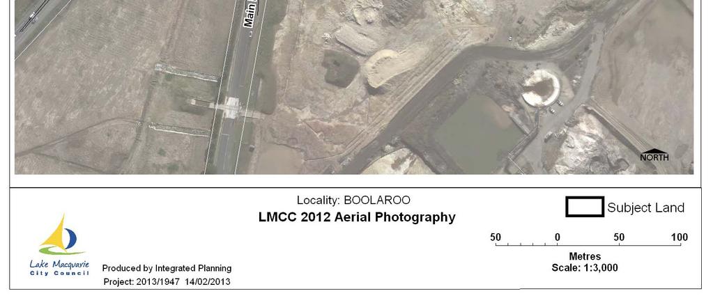
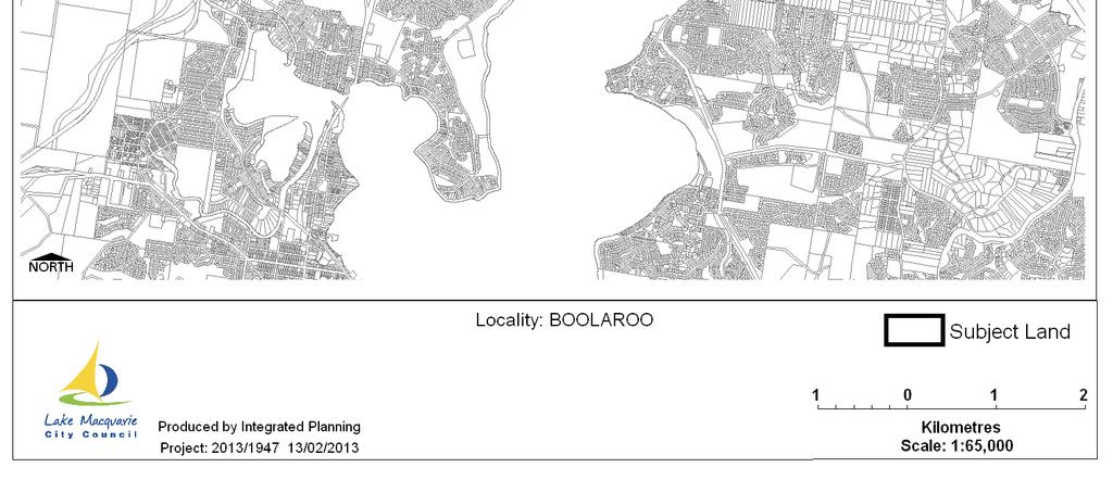
13 Attachment 2 Aerial Photo
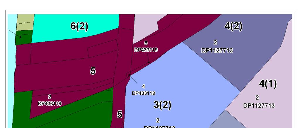

14 Attachment 3 - Current Zoning - LMLEP 2004
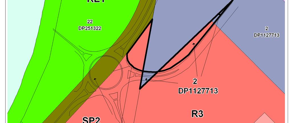
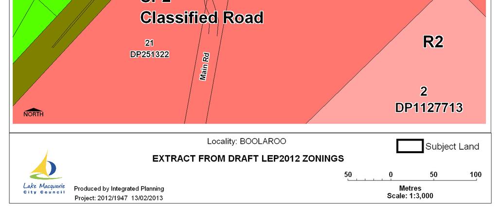
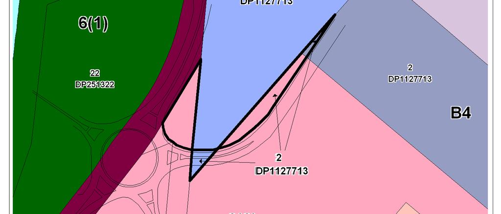
15 Attachment 4 - Zoning - Draft Lake Macquarie LEP 2013
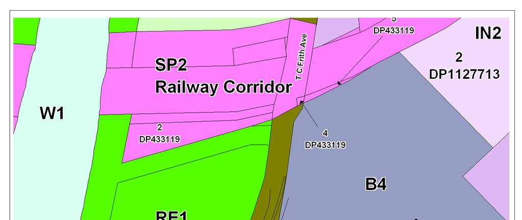
16 Attachment 5- Proposed Zoning Draft Amendment No. 77 to Lake Macquarie LEP 2004
17 Attachment 6 - Proposed Zoning Draft Lake Macquarie LEP 2013
18 Part 5 - Details of Community Consultation The planning proposal was exhibited from 24 June 2013 to 8 July 2013 in accordance with the Gateway determination. No submissions were received from the general public. Two responses were received from government agencies noting no objections to the planning proposal. The Roads and Maritime Service raised no objections or issues with the planning proposal. The Mine Subsidence Board raised no objection to the planning proposal and advised that the applicant should be advised to seek the Board s approval for the subdivision or the erection of improvements.
19 Part 6 Project Timeline The project timeline is below to the requirements of the Gateway Determination. Task Commencement Date Gateway Determination Timeframe for completion of technical information Timeframe 5 June 2013 Government Agency Consultation June 2013 Commencement and Completion Dates for Public Exhibition Period No further technical information is deemed required. Monday 24 June 2013 Monday 8 July 2013 Dates for Public Hearing Timeframe for Consideration of Submissions Timeframe for the consideration of a proposal post exhibition Public hearing is not likely necessary Late July 2013 August 2013 Submission to DoPI to finalise LEP August 2013 Date RPA finalised the plan (if delegated) 26 August 2013 Date RPA sent to DoPI for notification 28 August 2013 Date Plan Made and Published 6 September 2013
20 Attachment 7 Amendment No. 77 to Lake Macquarie LEP 2004 Final Instrument and Map
21
22
Planning Proposal Toronto Road, Booragul. Amendment to Lake Macquarie Local Environmental Plan (LMLEP) 2014
 2014") Planning Proposal Toronto Road, Booragul Amendment to Lake Macquarie Local Environmental Plan (LMLEP) 2014 Local Government Area: Name of Draft LEP: Subject Land: Land Owner: Applicant: Folder Number:
Planning Proposal Toronto Road, Booragul Amendment to Lake Macquarie Local Environmental Plan (LMLEP) 2014 Local Government Area: Name of Draft LEP: Subject Land: Land Owner: Applicant: Folder Number:
Planning Proposal Wangi Power Station Complex Administrative Amendment Lake Macquarie Local Environmental Plan 2014
 Planning Proposal Wangi Power Station Complex Administrative Amendment Lake Macquarie Local Environmental Plan 2014 (Post Exhibition Version) Local Government Area: Name of Draft LEP: Subject Land: Land
Planning Proposal Charlestown Swim and Leisure Centre LEP Amendment
 Planning Proposal Charlestown Swim and Leisure Centre LEP Amendment Amendment No. 4 to Lake Macquarie Local Environmental Plan 2014 (PP_2014_LAKEM_005_00) Local Government Area: Name of Draft LEP: Lake
Planning Proposal Concurrent DA/LEP Amendment for Belmont North Pharmacy Amendment No. 24 to Lake Macquarie Local Environmental Plan (LMLEP) 2014
 2014") Planning Proposal Concurrent DA/LEP Amendment for Belmont North Pharmacy Amendment No. 24 to Lake Macquarie Local Environmental Plan (LMLEP) 2014 Local Government Area: Name of Draft LEP: Subject Land:
Planning Proposal Concurrent DA/LEP Amendment for Belmont North Pharmacy Amendment No. 24 to Lake Macquarie Local Environmental Plan (LMLEP) 2014 Local Government Area: Name of Draft LEP: Subject Land:
Planning Proposal under section 55 of the EP&A Act
 FOR PUBLIC EXHIBITION [Brief description] Monday 10 October to Monday 27 October 2014 Planning Proposal under section 55 of the EP&A Act Port Macquarie-Hastings LEP 2011 (Amendment No 32) Mixed land zone
Planning Proposal. Council Adopted Version
 Planning Proposal Amendment No.6 to Lake Macquarie Local Environmental Plan 2014 Warners Bay Town Centre Deferred Matter Dept Planning & Environment Reference No. PP_2014_LAKEM_001_00 Council Adopted Version
Planning Proposal. Part of the Former Swansea Bowling Club Rezoning at Charles Street and Lake Road, Swansea
 Planning Proposal Part of the Former Swansea Bowling Club Rezoning at Charles Street and Lake Road, Swansea Draft Amendment No. 26 to Lake Macquarie Local Environmental Plan 2014 As Published 16/03/2018
Planning Proposal Environmental and Recreation Zone Review Stage One
 Planning Proposal Environmental and Recreation Zone Review Stage One Local Government Area Name of Draft LEP: Subject Land: Lake Macquarie City Lake Macquarie Local Environmental Plan 2014 Environmental
Planning Proposal. Extension of West Wallsend Heritage Conservation Area Draft Amendment No. RZ/1/2015 to Lake Macquarie Local Environmental Plan 2014
 Planning Proposal Extension of West Wallsend Heritage Conservation Area Draft Amendment No. RZ/1/2015 to Lake Macquarie Local Environmental Plan 2014 AS ADOPTED ON 22 AUGUST 2016 Local Government Area:
Planning Proposal. Rockdale Local Environmental Plan Two storey residential development in the R2 and R3 zones
 Planning Proposal Rockdale Local Environmental Plan 2011 Two storey residential development in the R2 and R3 zones 16 October 2014 Contents Part 1 Part 2 Part 3 Part 4 Part 5 A statement of the Objectives
Part 4.25 Pasminco Area Plan
 1 INTRODUCTION The purpose of this Area Plan is to guide the redevelopment of the former Pasminco Cockle Creek Smelter site and the former Incitec Pivot Fertilizer site. The Pasminco and Incitec sites
Planning Proposal (PP007) Rezoning of Kylor Pty Ltd Land at Manyana
 Rezoning of Kylor Pty Ltd Land at Manyana") Planning Proposal (PP007) Rezoning of Kylor Pty Ltd Land at Manyana Prepared by Planning & Development Services Group Shoalhaven City Council File 50064E Version 1 - Gateway March 2015 Shoalhaven City
Planning Proposal (PP007) Rezoning of Kylor Pty Ltd Land at Manyana Prepared by Planning & Development Services Group Shoalhaven City Council File 50064E Version 1 - Gateway March 2015 Shoalhaven City
Draft Ada Street Cardiff Area Plan
 Draft Ada Street Cardiff Area Plan (Draft Amendment to Lake Macquarie Development Control Plan 2014) Exhibition: The draft Area Plan is on public exhibition from 29 February 2016 to 29 March 2016. Submissions:
Lake Macquarie Development Control Plan 2014 Revision 19. Adopted by Council 25 June 2018
 Lake Macquarie City Council Lake Macquarie Development Control Plan 2014 Revision 19 DISCLAIMER When preparing and assessing development applications, the summarised changes outlined in the revision history
Planning Proposal Belmont Sportsman s Club Draft Amendment No. 65 to Lake Macquarie Local Environmental Plan (LM LEP) 2004
 2004") Planning Proposal Belmont Sportsman s Club Draft Amendment No. 65 to Lake Macquarie Local Environmental Plan (LM LEP) 2004 Local Government Area: Name of Draft LEP: Lake Macquarie City Council (LMCC) Lake
Planning Proposal Belmont Sportsman s Club Draft Amendment No. 65 to Lake Macquarie Local Environmental Plan (LM LEP) 2004 Local Government Area: Name of Draft LEP: Lake Macquarie City Council (LMCC) Lake
Draft Eastern District Plan
 Draft Eastern District Plan Submission_id: 31238 Date of Lodgment: 13 Dec 2017 Origin of Submission: Online Organisation name: Turrulla Gardens Pty Ltd C/- Mecone Organisation type: Industry First name:
Tāhuhu whakaruruhau ā-taone The sheltering ridge pole
 B2. Tāhuhu whakaruruhau ā-taone - Urban growth and form B2.1. Issues Tāhuhu whakaruruhau ā-taone The sheltering ridge pole Auckland s growing population increases demand for housing, employment, business,
Plan Modification to Chapter B2 of the Auckland Unitary Plan(AUP) Operative in part (15 November 2016)
 Operative in part (15 November 2016)") UNITARY PLAN UPDATE REQUEST MEMORANDUM TO FROM Phill Reid Linley Wilkinson DATE 25 September 2018 SUBJECT Plan Modification to Chapter B2 of the Auckland Unitary Plan(AUP) Operative in part (15 November
UNITARY PLAN UPDATE REQUEST MEMORANDUM TO FROM Phill Reid Linley Wilkinson DATE 25 September 2018 SUBJECT Plan Modification to Chapter B2 of the Auckland Unitary Plan(AUP) Operative in part (15 November
Lake Macquarie Development Control Plan 2014 Revision 19
 Lake Macquarie Development Control Plan 2014 Revision 19 Part 8 Subdivision Development Adopted by Council 25 June 218 Page 0 F2018/00436 TABLE OF CONTENTS: 1 INTRODUCTION... 4 1.1 HOW TO USE THIS PLAN...
WATERLOO STATE SIGNIFICANT PRECINCT SUMMARY OF STUDIES
 WATERLOO STATE SIGNIFICANT PRECINCT SUMMARY OF STUDIES Technical studies will be undertaken to inform the master planning process for the Waterloo precinct to develop a Precinct Proposal to redevelop the
Queensland Coastal Plan. Presented by John Lane Director Environment Planning
 Queensland Coastal Plan Presented by John Lane Director Environment Planning Queensland Coastal Plan - Status Released 7 April 2011, but NOT YET IN EFFECT Formatting & operational amendments required Yet
DAREBIN PLANNING SCHEME AMENDMENT C137
 Who is the planning authority? Planning and Environment Act 1987 DAREBIN PLANNING SCHEME AMENDMENT C137 EXPLANATORY REPORT This amendment has been prepared by the Darebin City Council, who is the planning
Appendix A. Planning Processes. Introduction
 1 Planning Processes Introduction This appendix outlines a number of planning processes which are used in the Auckland Region to support the effective management of development in the region s rural and
Appendix 7 Precinct Analysis Carlton
 Appendix 7 Precinct Analysis Carlton (Andover Street) Rezone from R2 Low Density Residential to R3 Medium Density Residential Retain existing B1 Neighbourhood Centre zone Existing Zoning Map (R2 Low Density
Part 12 Precinct Area Plans - Wyee West
 TABLE OF CONTENTS 1 INTRODUCTION... 1 1.1 BACKGROUND... 1 1.2 EXTENT OF AREA PLAN... 1 1.3 EXISTING CHARACTER... 2 1.4 ENVIRONMENTAL ATTRIBUTES AND CONSTRAINTS... 2 1.5 DESIRED FUTURE CHARACTER... 3 1.6
Planning Proposal Rockdale Local Environmental Plan Russell Avenue, Dolls Point
 Planning Proposal Rockdale Local Environmental Plan 2011 177 Russell Avenue, Dolls Point [February 2017] Contents Part 1 - A statement of the Objectives or Intended Outcomes of the proposed LEP Part 2
Lake Macquarie Development Control Plan 2014 Revision 17
 Lake Macquarie Development Control Plan 2014 Revision 17 Part 4 Development in Business Zones Page 0 F2017/00418 Table of Contents: 1 INTRODUCTION... 4 1.1 HOW TO USE THIS PLAN... 4 1.2 ADDITIONAL CONTROLS
Connell Wagner Pty Ltd ABN PO Box 19 The University of Newcastle Union Callaghan New South Wales 2308 Australia
 Connell Wagner Pty Ltd ABN 54 005 139 873 PO Box 19 The University of Newcastle Union Callaghan New South Wales 2308 Australia Telephone: +61 2 4941 5415 Facsimile: +61 2 4941 5489 Email: cwntl@conwag.com
Subdivision Design Criteria. Penihana North GUIDELINES TO THE RULES
 Created September 2013 Penihana North Subdivision Design Criteria GUIDELINES TO THE RULES This part of the Plan sets out the design criteria for subdivision in Penihana North. The criteria will be considered
Lake Macquarie Development Control Plan 2014 Revision 17
 Lake Macquarie Development Control Plan 2014 Revision 17 Part 3 Development within Residential Zones Draft LMCC DCP 2014 Page 1 F2009/00952 Version 4 Exhibition Draft July 2012 TABLE OF CONTENTS: 1 INTRODUCTION...
Lake Macquarie Development Control Plan Revision 20
 Lake Macquarie Development Control Plan 2014 - Revision 20 LMCC DCP 2014 Revision 20 Page 0 F2016/01470 TABLE OF CONTENTS: 1 INTRODUCTION... 3 1.1 HOW TO USE THIS PLAN... 3 1.2 ADDITIONAL CONTROLS FOR
PLANNING PROPOSAL Draft Amendment to Wyong LEP 1991
 PLANNING PROPOSAL Draft Amendment to Wyong LEP 1991 9-11 and 31-39 The Entrance Road West, 1-11 and 4 Bent Street (and Bent Street itself), 3-9 and 6 Oakland Avenue (and part of this road) and 2,3 & 4
Part 6 Reference Material
 Part 6 of this DCP provides: Part 6.1 provides a summary of the legislation, documents, maps and Statutory Authorities referred to throughout the DCP. These are mainly sourced from Part 2 General Principles
MDP -- District Plan Webform Submissions Submission Details
 MDP -- District Plan Webform Submissions Submission Details Completed Time Represented By Who Title Age Bracket 03/31/2017-16:44 I am submitting my Mr 40-49 organisation's submission First Name Last Name
Department of Planning
 NSW GOVERNMENT Department of Planning Contact: Sumathi Navaratnam Phone: 02 9228 6361 Fax: 02 9228 6540 E-mail: sumathi.navaratnam@planning.nsw.gov.au Mr Robert Domm Chief Executive Officer Redfern - Waterloo
SECTION 7A: WHAKARONGO RESIDENTIAL AREA
 SECTION 7A: WHAKARONGO RESIDENTIAL AREA CONTENTS 7A.1 Introduction 1 7A.2 Resource Management Issues 1 7A.3 Objectives and Policies 1 7A.4 Methods 4 7A.5 Residential Zone 4 7A.5.1 Rules: Controlled Activities
Development Control Plan
 Development Control Plan Rhodes Corporate Park (Also known as the Digital Site) Development Control Plan Date of Adoption: 4 September 2007 Effective Date: 7 March 2008 Index 1 INTRODUCTION... 3 1.1 LAND
SCHEDULE 10 TO THE URBAN GROWTH ZONE. Shown on the planning scheme map as UGZ10. Truganina Precinct Structure Plan. 1.0 The Plan
 SCHEDULE 10 TO THE URBAN GROWTH ZONE Shown on the planning scheme map as UGZ10 Truganina Precinct Structure Plan 1.0 The Plan Map 1 shows the future urban structure proposed in the Truganina Precinct Structure
Lake Macquarie Development Control Plan 2014 Revision 20
 Lake Macquarie Development Control Plan 2014 Revision 20 TABLE OF CONTENTS: 1 INTRODUCTION... 3 1.1 HOW TO USE THIS PLAN... 3 1.2 ADDITIONAL CONTROLS FOR SPECIFIC LAND USES... 3 1.3 AIMS FOR DEVELOPMENT
AMENDMENTS. Date Effective. Amendment No. Council. DCP 14 Davidson St, Greenacre Page 2
 AMENDMENTS Amendment No. Description Adopted by Council Date Effective DCP 14 Davidson St, Greenacre Page 2 TABLE OF CONTENTS 1.0 INTRODUCTION... 4 1.1 NAME OF THIS PLAN... 4 1.2 COMMENCEMENT OF DEVELOPMENT
DRAFT GREATER SYDNEY REGION PLAN OBJECTIVES, STRATEGIES AND ACTIONS
 Greater Sydney Commission DRAFT GREATER SYDNEY REGION PLAN OBJECTIVES, STRATEGIES AND ACTIONS Issued: 26 OCTOBER 2017 Version: 1 Subject: Greater Sydney Region and District Plans This information note
CITY OF FREMANTLE LOCAL PLANNING SCHEME NO. 4 AMENDMENT NO. 68 SCHEME AMENDMENT REPORT
 CITY OF FREMANTLE LOCAL PLANNING SCHEME NO. 4 AMENDMENT NO. 68 SCHEME AMENDMENT REPORT CITY OF FREMANTLE PLANNING AND DEVELOPMENT SERVICES 8 WILLIAM STREET FREMANTLE WA 6160 PLANNING AND DEVELOPMENT ACT
Statement of Environmental Effects
 Statement of Environmental Effects Pro-forma for minor development This pro-forma may be used for minor development proposals that require a development application. This pro-forma is not comprehensive
Exhibition of Oran Park and Turner Road Precincts
 22 June 2007 Growth Centres Commission Mr. Angus Dawson PO Box 1457 PARRAMATTA NSW 2124 Dear Sir Exhibition of Oran Park and Turner Road Precincts UDIA NSW commends the Growth Centres Commission (GCC)
RURAL ZONE - POLICY. Rural Zone Policy. Issue: Rural Environment. Ruapehu District Plan Page 1 of 8
 Rural Zone Policy RU2 RURAL ZONE - POLICY RU2.1 Introduction The natural resources of the rural environment in the Ruapehu District provide the basis for the existing and potential character, intensity
Greater Geelong Planning Scheme Proposed Planning Scheme Amendment C and 5-19 Princes Highway, Norlane
 Greater Geelong Planning Scheme Proposed Planning Scheme Amendment C253 PLANNING SUBMISSION prepared for Bunnings Group Ltd by SJB Planning Pty Ltd Level 1, Building D 80 Dorcas Street SOUTHBANK VIC 3006
Town Planning Report. Combined Planning Permit and Planning Scheme Amendment Request under Section 96A of the Planning and Environment Act 1987
 Town Planning Report Combined Planning Permit and Planning Scheme Amendment Request under Section 96A of the Planning and Environment Act 1987 1 Henry Street, Belmont Prepared by Tract Consultants for
HS2 Interchange Station Design
 Working on behalf of HS2 Interchange Station Design October 2018 www.hs2.org.uk 1 Interchange Station, Solihull Introduction In February 2018, HS2 Ltd appointed Arup to take forward the design of Interchange
CASEY PLANNING SCHEME AMENDMENT C188
 Who is the planning authority? Planning and Environment Act 1987 CASEY PLANNING SCHEME AMENDMENT C188 EXPLANATORY REPORT This amendment has been prepared by the Growth Areas Authority (now known as the
Leading environmental solutions...
 Leading environmental solutions... About Us Australian Wetlands Consulting (AWC) is a multi-award winning environmental design and consulting company committed to creating a better environment through
REVISED DRAFT NORTH DISTRICT PLAN PLANNING PRIORITIES AND ACTIONS
 Greater Sydney Commission REVISED DRAFT NORTH DISTRICT PLAN PLANNING PRIORITIES AND ACTIONS Issued: 26 OCTOBER 2017 Version: 1 Subject: Greater Sydney Region and District Plans This information note is
Warners Bay Town Centre
 Warners Bay Town Centre Planning Workshop 1 of 2 Tuesday 6 August 2013 Opening Introduction Outline and purpose of workshops Housekeeping Group introductions Group introductions 1. People at tables to
DRAFT WESTERN CITY DISTRICT PLAN PLANNING PRIORITIES AND ACTIONS
 Greater Sydney Commission DRAFT WESTERN CITY DISTRICT PLAN PLANNING PRIORITIES AND ACTIONS Issued: 26 OCTOBER 2017 Version: 1 Subject: Greater Sydney Region and District Plans This information note is
Newcourt Masterplan. November Exeter Local Development Framework
 Newcourt Masterplan November 2010 Exeter Local Development Framework Background The Exeter Core Strategy Proposed Submission sets out the vision, objectives and strategy for the development of Exeter up
Appendix 1 Structure plan guidelines
 Appendix 1 Structure plan guidelines This appendix forms part of the regional policy statement [rps]. 1.1. Introduction Structure plans are an important method for establishing the pattern of land use
Wingecarribee Shire Council
 Connell Wagner Pty Ltd ABN 54 005 139 873 2 Palmer Street North Parramatta New South Wales 2151 Australia Telephone: +61 2 8896 4100 Facsimile: +61 2 9890 3558 Email: cwpar@conwag.com www.conwag.com Moss
Governance and master planning in the NSW planning system
 Governance and master planning in the NSW planning system 27 August 2014 Lecture University of NSW Built Environment Alice Spizzo Director, Planning & Environment aspizzo@landerer.com.au Ref: NSW Department
RE: AMENDMENT C375 GEELONG PLANNING SCHEME 1900 BARWON HEADS ROAD, BARWON HEADS
 Reference: #V157080 14 August 2018 Barwon Heads Lifestyle Group Pty Ltd C/- Best Hooper Lawyers Level 9, 451 Little Bourke Street MELBOURNE VIC 3000 Attention: Mr. Edward Mahony (Lawyer) Dear Edward RE:
Draft Western District Plan
 Powered by TCPDF (www.tcpdf.org) Draft Western District Plan Submission_id: 31440 Date of Lodgment: 15 Dec 2017 Origin of Submission: Online Organisation name: Goodman Property Services Australia Pty Ltd
KELLS DEVELOPMENT PLAN
 KELLS DEVELOPMENT PLAN 2013-2019 J Statement Outlining Compliance with Ministerial Guidelines Adopted 7th October 2013 APPENDIX J STATEMENT OUTLINING COMPLIANCE WITH MINISTERIAL GUIDELINES Under section
Legal implications of failing to
 Legal implications of failing to plan for sea level rise Gavin Leydon, Partner 30 April 2010 Outline Relevance to local l government & developers assessment & policy Developments in case law Climate change
May Request for Secretary s Environmental Assessment Requirements
 May 2018 Request for Secretary s Environmental Assessment Requirements Sydney Metro City & Southwest Waterloo Over Station Development (Waterloo Metro Quarter Precinct) Table of Contents 1. Introduction...
Site Assessment Technical Document Appendix A: Glossary
 Central Bedfordshire Council www.centralbedfordshire.gov.uk Site Assessment Technical Document Appendix A: Glossary July 2017 1.1.11-1 - ii Appendix A: Glossary Term Agricultural Land Classification AONB
Welcome to our exhibition
 Welcome to our exhibition The Homes & Communities Agency (HCA) welcomes you to this public exhibition explaining our proposals for the redevelopment of the former Lea Castle Hospital site. About the Homes
TIDAPA Structure Plan
 TIDAPA Structure Plan Prepared by Tract Consultants 28 MARCH 2017 0217-0074 Table of Contents 01 STRATEGIC CONTEXT Executive Summary Regional Context Page 3 Page 4 02 LOCAL CONTEXT Aerial Photograph Local
Planning and Providing Our Infrastructure
 Item: 13.06 Subject: THRUMSTER DEVELOPMENT CONTROL PLAN: REFORMATTING AND INCLUSION OF NEW PROVISIONS FOR SOUTH OXLEY - SUBMISSIONS REPORT Presented by: Development & Environment, Matt Rogers Alignment
MERIDAN PLAINS SAND RESOURCE AREA
 MERIDAN PLAINS SAND RESOURCE AREA INFORMATION SHEET October 2010 BACKGROUND The Meridan Plains Extractive Resource Area is located on the western fringe of the coastal urban communities of Caloundra West
Description Details submitted pursuant to discharge of condition 5 (Design Code) attached to planning permission 13/01729/OUT.
 attached to planning permission 13/01729/OUT.") ITEM 9 Application Number: 18/00266/DISCON Description Details submitted pursuant to discharge of condition 5 (Design Code) attached to planning permission 13/01729/OUT. AT The Point, 602 Midsummer Boulevard,
ITEM 9 Application Number: 18/00266/DISCON Description Details submitted pursuant to discharge of condition 5 (Design Code) attached to planning permission 13/01729/OUT. AT The Point, 602 Midsummer Boulevard,
Introduction. Welcome to this consultation regarding the draft redevelopment proposals for the former CeramTec factory on Sidmouth Road, Colyton.
 Introduction Welcome to this consultation regarding the draft redevelopment proposals for the former CeramTec factory on Sidmouth Road, Colyton. We are currently considering options for the mixed-use redevelopment
Section 3b: Objectives and Policies Rural Environment Updated 19 November 2010
 Page 1 of Section 3b 3b RURAL ENVIRONMENT 3b.1 Introduction The Rural Environment comprises all the land outside of the Residential, Town Centre and Industrial Environments. Most land within the District
Urban Growth Boundaries
 Urban Growth Boundaries Discussion Document July 2008 Contents page Introduction... 3 What are urban growth boundaries?... 3 The need to manage growth... 3 Purpose of urban growth boundaries... 4 How will
INCREMENTAL CHANGE AREA REVIEW March 2015 Page 1
 INCREMENTAL CHANGE AREA REVIEW March 2015 Page 1 Table of Contents Introduction... 3 Background to Review... 3 Comparison of the Schedules to the General Residential Zone... 7 Methodology... 7 Policy Context...
Local Area Key Issues Paper No. 11: Extractive industry - Yandina Creek and Browns Creek Road
 Draft Sunshine Coast Planning Scheme Review of Submissions Local Area Key Issues Paper No. 11: Extractive industry - Yandina Creek and Browns Creek Road Key Issue: No. of submissions: Sites identified
Re: The Northern Road and 1-29 Bradley Street, Glenmore Park Submission to Draft Sydney West District Plan
 3 April 2017 Mr. Sean O Toole West District Commissioner Greater Sydney Commission PO Box 257 Parramatta NSW 2124 Dear Sean, Re: 2065-2113 The Northern Road and 1-29 Bradley Street, Glenmore Park Submission
North District What we heard
 What we heard Vision to 2056 and Priorities Governance and implementation Infrastructure and funding The vision for a metropolis of three cities, and the 30 minute city. Feedback emphasised: That for the
PLANNING PROPOSAL AMENDMENT TO PENRITH LOCAL ENVIRONMENTAL PLAN 2010 REZONING AND RECLASSIFICATION OF 7 SITES IN ERSKINE PARK AND ST CLAIR
 PLANNING PROPOSAL AMENDMENT TO PENRITH LOCAL ENVIRONMENTAL PLAN 2010 REZONING AND RECLASSIFICATION OF 7 SITES IN ERSKINE PARK AND ST CLAIR Contents Executive Summary... 5 1.1 Introduction... 7 1.1 Background:
Draft South West District Plan - Campbelltown City Council Submission Attachment 1
 Draft South West District Plan - Campbelltown City Council Submission Attachment 1 Campbelltown City Council Report and Resolution - Draft South West District Plan - Draft Submission Ordinary Meeting 28/03/17
COMMISSION ACTION FORM
 ITEM #: 6 DATE: 09-06-17 COMMISSION ACTION FORM REQUEST: Introduction and Initial Review of Proposed Amendments to the Ames Urban Fringe Future Land Map for the North Growth Gap Area BACKGROUND INFORMATION:
As will be detailed, our site plays a strategic role in providing these opportunities.
 29 March 2017 Greater Sydney Commission PO Box 257 Parramatta NSW 2124 Email: info@gsc.nsw.gov.au Dear Sir/Madam, RE: DISTRICT PLAN-SOUTH WEST AREA. Woodward Park and Liverpool CBD. I have been requested
Northern Territory Compact Urban Growth Policy
 Northern Territory Compact Urban Growth Policy A Reference Policy Document to clause 2.7 (Reference to Policy) of the NT Planning Scheme May 2015 Table of Contents 1 Policy Setting... 3 1.1 Context for
AGINCOURT SECONDARY PLAN
 1 AGINCOURT SECONDARY PLAN 1. AGINCOURT SECONDARY PLAN The following policies and principles apply to the area herein referred to as Agincourt, as outlined on Map 1-1. 1. GENERAL POLICIES 1.1 This Secondary
25 AVALON ROAD, AVALON
 Development Hearings Panel Page 1 Application No: 1200/2015 Applicant: Subject Land: Owner: Zone: Overlays: Existing Use: Proposed Use: Ivelja Design 25 Avalon Road, Avalon C J Bate and S M Bate Farming
Ipswich Issues and Options for the Ipswich Local Plan Review, August 2017, Public Consultation
 Ipswich Issues and Options for the Ipswich Local Plan Review, August 2017, Public Consultation Having reviewed the issues and options documents, the Society has made the following response: Part 1 Strategic
SPG 1. * the northern and western sections which are open fields used for pasture and grazing;
 SPG 1 1.0 INTRODUCTION This development brief is based on the allocation of the Priors Hall site for employment and countryside recreational purposes in the Corby Borough Local Plan. The brief is intended
PART 5 - NATURAL AND PHYSICAL ENVIRONMENT
 CONTENTS...PAGE 5.1 INTRODUCTION...3 5.2 NATURAL RESOURCES...4 5.3 PHYSICAL RESOURCES...4 5.4 COASTAL ENVIRONMENT...4 5.5 HERITAGE FEATURES...4 5.6 HAZARDS...4 5.7 SUMMARY...4 ISTHMUS SECTION - OPERATIVE
SOUTH CAMBRIDGESHIRE DISTRICT COUNCIL. REPORT TO: Planning Committee 1 April 2015 Planning and New Communities Director
 SOUTH CAMBRIDGESHIRE DISTRICT COUNCIL REPORT TO: Planning Committee 1 April 2015 AUTHOR/S: Planning and New Communities Director Application Number: Parish(es): Proposal: Site address: Applicant(s): Recommendation:
WELLINGTON CITY DISTRICT PLAN
 Section 32 Report WELLINGTON CITY DISTRICT PLAN PROPOSED DISTRICT PLAN CHANGE 54 REZONING 178 AND 180 OWHIRO BAY PARADE 1 Introduction Before a Proposed District Plan change is publicly notified the Council
DONCASTER METROPOLITAN BOROUGH COUNCIL. PLANNING COMMITTEE 3 rd May Expiry Date:
 DONCASTER METROPOLITAN BOROUGH COUNCIL PLANNING COMMITTEE 3 rd May 2016 Application 7 Application Number: 16/00741/FUL Application Expiry Date: 3 rd May 2016 Application Type: Full application Proposal
EAST VILLAGE STRATEGIC SITE NOVEMBER 2017
 EAST VILLAGE STRATEGIC SITE NOVEMBER 2017 East Village will be a sustainable, mixeduse precinct with a focus on innovative employment and education opportunities. Enhanced by green spaces and places for
Humber Bay Shores Precinct Plan Final Report
 STAFF REPORT ACTION REQUIRED Humber Bay Shores Precinct Plan Final Report Date: May 21, 2010 To: From: Wards: Reference Number: Etobicoke York Community Council Director, Community Planning, Etobicoke
I539. Smales 2 Precinct
 I539. Smales 2 Precinct I539.1. Precinct Description The Smales 2 Precinct applies to a 4.8 hectare block of land located on the southern side of Northcote Road and fronting Lake Pupuke, Takapuna. The
Shoalhaven City Council
 Shoalhaven City Council MINUTES OF THE DEVELOPMENT COMMITTEE Meeting Date: Tuesday, 14 November 2017 Location: Council Chambers, City Administrative Building, Bridge Road, Nowra Time: 5.04pm The following
SECTION 2.4 URBAN DEVELOPMENT AND STRATEGIC URBAN DIRECTIONS
 SECTION 2.4 URBAN DEVELOPMENT AND STRATEGIC URBAN DIRECTIONS 2.4.1 INTRODUCTION In 1993/94 the Hastings District Council completed the Hastings Urban Development Strategy. The purpose of this study was:
Reserved Matters application for a site that straddles the boundary between CBC and BBC
 BBC APPLICATION 15/02682/MAR NUMBER CBC APPLICATION CB/15/04294/RM NUMBER LOCATION Wixams Land at former storage depot, Bedford Road, Wilstead Bedfordshire PROPOSAL Reserved Matters Application for Strategic
I615. Westgate Precinct
 I615. Westgate Precinct I615.1. Precinct Description The Westgate Precinct is located approximately 18km west of the Auckland city centre. There are seven Sub-precincts in the Westgate Precinct: Sub-precinct
Great Easton Neighbourhood Plan Statement of Basic Conditions
 Great Easton Neighbourhood Plan 2017-2031 Statement of Basic Conditions OCTOBER 2016 GREAT EASTON PARISH COUNCIL Contents 1.0 Introduction....Page 2 2.0 Summary of Submission Documents and Supporting Evidence..
Stage 2: WestConnex M5 King Georges Road Interchange Upgrade. Appendix B5 Construction Heritage Management Plan
 Stage 2: WestConnex M5 King Georges Road Interchange Upgrade Appendix B5 Construction Heritage Management Plan JULY 2016 DOCUMENT CONTROL File name Report name CEMP App B5 CHMP Rev E Revision number E
I611. Swanson North Precinct
 I611. Swanson North Precinct I611.1. Precinct Description Swanson North is located in the north eastern foothills of the Waitakere Ranges. It is outside the Waitakere Ranges Heritage Area Act and the Waitakere
Part 10 Other plans
 Contents of Part 10 Part 10 Other plans... 10-1 10.1 Preliminary... 10-1 10.2 Palmview Structure Plan... 10-2 10.2.1 Preliminary... 10-2 10.2.2 Master Strategic Framework... 10-6 10.2.3 Master Precincts
4.3 Dudley Area Plan. Introduction. History and Existing Character. Desired Future Character for Dudley
 4.3 Dudley Area Plan Introduction The suburb of Dudley has developed as a result of various circumstances including its topography, history and mineral resources. Dudley development has been identified