URBAN DESIGN BRIEF.. on behalf of the owner..sunningdale Commercial Inc.
|
|
|
- Cleopatra Kelly Holland
- 5 years ago
- Views:
Transcription


1 URBAN DESIGN BRIEF.. on behalf of the owner..sunningdale Commercial Inc.. in support a Site Plan Approval Application to permit a Shopping Areas commercial centre. at 1830 Adelaide Street North, in the City of London. March 2018
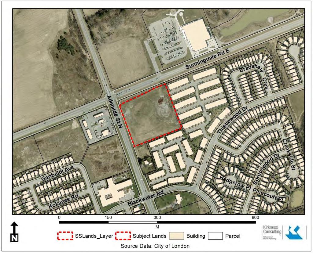
2 SECTION 1 - LAND USE PLANNING CONTEXT 1.1 Subject Lands Municipal Address: Owned by Stoney Creek Commercial Inc. is the subject 1830 Adelaide Street North at Sunningdale Road southeast quadrant. SEE Location Plan. Site Dimensions: regular rectangular shaped site, with a total land area of 2.17 ha with m frontage along Adelaide Street North, and m of frontage along Sunningdale Road. It is currently undeveloped and vacant. Official Plan land use designation: Schedule A, Land Use designates the lands as NEIGHBOURHOOD COMMERCIAL NODE. The policy on FUNCITION reads, Neighbourhood Commercial Nodes are intended to provide for the daily or weekly convenience shopping and service needs of nearby residents and, to a lesser extent, passing motorists. They should contain uses that are convenience-oriented and unlikely to draw customers from beyond the local area. The FORM is also set out in policy as it reads, Neighbourhood Commercial Nodes generally have a strip plaza focus with a combination of small free-standing uses or small uses in a plaza format but can be applied to a collection of small stores intended to serve the surrounding neighbourhood. Free-standing structures along the street frontage should be developed to improve the design of the street edge, provide access to transit stops and reduce the visual impact of large open parking lots. The design, appearance and scale shall be in harmony with the surrounding residential area with adequate screening and buffering between uses. Parking areas should be carefully designed and shared parking areas should be accommodated where possible. London Plan place type is SHOPPING AREA. Map 3 Street Classifications designates Sunningdale and Adelaide Street North as an CIVIC BOULEVARDS. Clause 876 sets out that a Plan is provided for a distribution of Shopping Area Place Types across the city to service neighbourhoods and collections of neighbourhoods.. Permitted uses are set out as well providing for (clause 877) a broad range of retail, service, office, entertainment, recreational, educational, institutional, and residential uses. Current Zoning: The City of London zones the subject lands as NEIGHBOURHOOD SHOPPING AREA (NSA1, NSA2 AND NSA5), which in its GENERAL PURPOSE STATEMENT provides for and regulates a range of neighbourhood-scale retail, personal service and office uses which are primarily intended to provide for the convenience shopping and service needs of nearby residents. Shopping centres are the permitted form of development, however, stand-alone buildings may also be permitted at appropriate locations normally near the perimeter of the property to satisfy urban design goals to create a street edge and screen parking lots. Site Characteristics: Topography the subject lands are generally flat and cleared with the grades flowing to the north. A large drainage ditch with UTRCA regulation is located along the north Sunningdale Road frontage. 1
3


4 Layout the site is regular in shape and has significant street frontage along both Sunningdale dale and Adelaide Street. Vegetation and Landscaping There is no significant natural heritage resource or hazards. Previous uses were cash crop agricultural. Existing Buildings There are no existing buildings on site. See photos below Site viewed from Sunning dale Road looking southeast and showing the UTRCA drainage area in the foreground centre. Site viewed from Adelaide Street looking northeast. Viewing site from Adelaide Street looking east SHOWING THE YM-YWCA on left. 2


5 Surrounding Land Uses: North Sunningdale Road and north of the road are vacant and cleared lands designated for commercial development. See photo below. South medium density townhouse development and zoned Residential R5, R6 and R8. Also, a group home use in a Neighbourhood Facilities zone. See two photos below. East medium density townhouse development and zoned Residential R5 and R6. See photo upper right. 3

 in a combination Residential R6 and R7 zone. See photo below. 1.")
6 1.2 Proposed Development Sunningdale Commercial Inc. is proposing a retail office centre on 2.17 ha of land, comprising the following. See SITE PLAN IN Appendix. Viewing the site from Adelaide showing southern boundary. West Adelaide Street North and existing commercial development (gas bar, car wash and TH restaurant) and similarly zoned Neighbourhood Shopping Area and Service Station. Also, some lands are under construction for medium density multi-family apartment development (left) in a combination Residential R6 and R7 zone. See photo below. 1. Four commercial buildings of 1 storey and a total of 5416 m2 of gross floor area comprising 25% Lot Coverage, specifically: a. Building 1 - A multi-tenant commercial building of 808 m2 gfa, in the northwest front corner of the site at the major intersection, which is estimated to have tenants of 112 m2 to 204 m2 unit sizes; b. Building 2 - A commercial building of 217 m2gfa intended to be occupied by a restaurants with drive a through. c. Building 3 - A large commercial building at the rear of the site for two major tenants (retail and food stores) totaling 3242 m2 gfa; d. Building 4 - A large commercial building at the rear of the site along the Adelaide Street frontage for one major tenants ( Pharmacy) totaling 1122 m2 gfa; In all, 9 different commercial tenants are proposed. 2. Two vehicular access points, one at the east limits along Sunningdale Road and one at the south limits along Adelaide Street North. The Environmental Assessment is currently underway for the Sunningdale / Adelaide intersection. The location of two access 4


7 points was determined based on the need for the site to provide full turns access to the property. 3. A Landscape total area of 3620 m2 which is 16.7% coverage that focuses on the perimeter and at the end of parking modules. 4. A parking and drive aisle area of 12,677 m2 which is 58% coverage. 5. Parking spaces of 288 spaces including barrier free spaces, and 20 bicycle spaces. Zoning requires 271 spaces. 6. A pedestrian grid network of sidewalks and walkways through the site providing for east-west and north-south connections. Of note is the pedestrian walkway at the south east corner of the site that connects to Thistlewood Drive part of the Stoney Creek South residential community and is illustrated below by City Map. Subject lands Public walkway Walkway extending from Thistlewood Drive to the southeast corner of the site. Upper typical view of walkway. Lower viewing to south easterly corner of site where walkway terminates onto the site. 5
8 1.3 Design Goals & Objectives The design objectives for commercial development of the commercial proposal arise primarily from : 1. the 1989 Official Plan, section 4.2 COMMERCIAL LAND USE DESIGNATIONS (urban design principles), section NEIGHBOURHOOD COMMERCIAL NODE, and section 11. URBAN DESIGN PRINCIPLES 2. London Plan - City Design Section and Shopping Area Policies to provide an attractive and quality commercial development that is economically viable, to serve the local area and beyond. is compatible with the scale and form of surrounding existing medium density residential uses, existing and future commercial uses and intensities; visually enhances the streetscapes along the Civic Boulevards; compliments the open space area to the south, south east and west. 1.4 Design Response to City Documents 1989 OFFICIAL PLAN Section sets out Urban Design Objectives to promote an aesthetically pleasing form of commercial development. encourage commercial development located along arterial roads, which serve as major entryways into the City, to meet a higher design standard; and, Discourage large, front yard surface parking areas; encourage street-oriented development; introduce a higher standard of landscaping; incorporate accessible pedestrian connections to transit facilities, to adjacent neighbouring residential areas and within large commercial developments; require joint access and the co-ordination of internal and external traffic movements. RESPONSE: From section 1.2 above and the design shown on the SITE PLAN and LANDSCAPE PLAN, the objectives are met. Section 11 of the Official Plan sets out Urban Design Policies for and the following is an explanation of how the relevant policies are satisfied. Notwithstanding the national tenants and their specific brand requirements, every effort has been made through site and building design to produce and attractive and aesthetically pleasing commercial centre with architectural harmony, by: The use of high quality materials comprising brick, block, stone, stucco and longboard siding together with appropriate glazing, geometric simple front door/prominent singular identification signage deign composition (High Design Standards iv); The architectural consistency of all four buildings for materials and composition, as shown on the elevations with the use of parapets to individualize tenants 6
9 (Architectural Continuity v) (Clause v) amended by Ministry Mod. Dec. 17/09); Street oriented development with front doors, glazing, landscaped setbacks and sitting areas (Pedestrian Traffic Areas viii); Noise Attenuation xviii) Where residential development is affected by adverse noise conditions, the use of urban design features such as building orientation, location of outdoor open space relative to the noise sources and noise attenuation measures will be encouraged; Well setback buildings from property lines and their height at 5 to 6 m so as to not adversely impact adjacent properties for sunlight access (Sunlight ix); Incorporating waste reduction facilities in order to encourage the reduction, re-use and recycling of waste (Waste Management xix); A comprehensive Landscape Plan that has been designed to enhance the appearance of building setback and yard areas, screen parking, loading, garbage and service facilities from adjacent properties and streets ( Landscape Design x); Ensuring all components are handicap accessible and with barrier free parking ( Accessibility Standards xii); Providing Parking and Loading facilities to facilitate maneuverability on site, and to reduce the traffic flow disruption to and from the property. (xiii Parking and loading facilities); Recognizing the Gateway location through the placement of buildings, landscape features, or the design and architecture of the buildings as described in section 1.2 with street orientation of some of the buildings and significant landscaping along the frontages. (Gateways xxi) LONDON PLAN In substance the policies of the London Plan are similar to the 1989 Official Plan. The following is an explanation of how the relevant policies are satisfied. INTENSITY parameters are satisfied of encouraging greater intensity, not exceeding 4 storeys (proposing 1 storey but facades appearing as two storeys), providing adequate offstreet parking (271 required and 288 provided), and 7
10 creating sufficient buffers to create compatibility. ( Section 878 of SHOPPING AREAS) FORM parameters are satisfied by creating a grid of driveways, having smaller scale commercial uses develop on pads along the street front with front entrances onto the public street as much as possible, having a well landscaped context and screening of interior parking areas from the public realm, including wide tree lined pedestrian facilities for comfortable, convenient connection within the site and to external facilities to the site such as transit stops, and creating central seating areas and parkette features to create public meeting places. (Section 879). The site design and building architecture have been developed within the context of the LONDON PLAN CITY DESIGN section. City Design objectives are set in the following: 1. Character 2. Street Network 3. Streetscapes 4. Public Space 5. Site Layout 6. Buildings Site Layout and Buildings are the focus of this analysis. SITE LAYOUT The proposed commercial development respects the physical and planned neighbourhood context based on Stoney Creek Plan and existing residential development. Proper landscaped and built form interfaces with adjacent land uses (sections ) can be seen in the landscape and site design and architectural elevations. The pedestrian system facilitating movement within the site and connection to adjacent sites and the surrounding neighbourhood (Section 255) establishes connectivity and safe movement between, and within, sites for pedestrians, cyclists, and motorists. Of note is the pedestrian access to the south east corner of the site. The placement of 4 buildings within a highly landscaped context (sections 256 and 259) speaks to creating an edge for a street wall, gaining a sense of enclosure and comfortable pedestrian environment. The drive through facilities is located away from front and exterior side yards and maintain direct pedestrian access to a building from the public sidewalk, and at the same time with the abundant landscaping enhance the streetscape amenity (Sections 263 and 264). Loading, garbage and other service areas are located at the southern area of the site. Garbage enclosures are provided. The use the enviroworxs below grade containment system is proposed so as not to detract from pedestrian connections nor have a negative visual impact from the street (section 266). BUILDINGS No blank walls are proposed along the street edges ( sections 285 and 286) The 1 and 2-like -looking storey buildings (section 286) achieve scale relationships that are comfortable for pedestrians, are 8
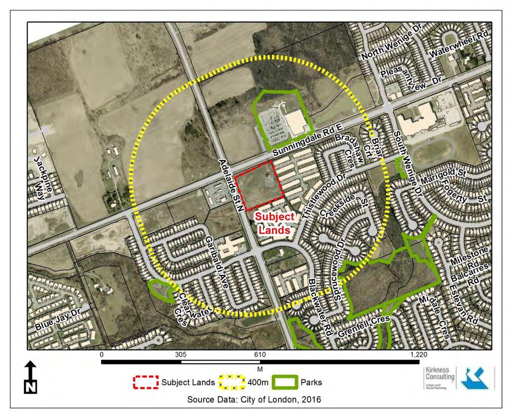
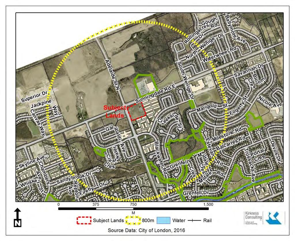
11 proportional to the width of the abutting public right-of-way to achieve a sense of enclosure. The corner sites should (sections 290 and 291) address the corner through building massing, location of entrances, and architectural elements, with principal building entrances and transparent windows located to face the public right-of-way and public spaces, reinforcing the public realm, and establishing an active frontage and convenient pedestrian access. Rooftop utility equipment would be screened from view (section 296) with equipment through facades or to be enclosed within the structure of the buildings and integrated into the overall building design. A diversity of materials is intended in the design of buildings to visually break up massing, reduce visual bulk and add interest to the building design (sections 301 and 302). Transparent glass is used abundantly on the majority of the ground level façades facing a public right-of-way to provide views into and out of the space and enhance the pedestrian environment (section 304). 1.5 Spatial Analysis The proposed development is located in a newly urbanizing area of the City, although a fair amount of development has taken place. The undeveloped lands are designated for future contemplated residential and commercial development Community Context - 400m & 800m The spatial analysis maps below show the community context. The 400 m radius Map shows the roads and streets with sidewalks. The notable features are the complimentary commercial uses on the southwest quadrant, the new multi- family apartment development to the lands also westerly, the YM-YWCA and Public Library to the north and east. The existing townhouse development to the south and east is apparent and the walkway leading into the residential Neighbourhood to the south and east at the southeast corner of the existing site. The 800 m radius map shows more of the same type of low and medium density forms of housing, extending to the west and northwest as well as east and north east. The larger Stoney Creek community to the east shows an Elementary School, Neighbourhood Park and Secondary School. The two Spatial Analysis Maps are shown on the following two pages SWOT ANALYSIS A brief account of strengths, weaknesses, opportunities and threats (SWOT) analysis of the site/proposal and its relation to the surrounding neighbourhood is outlined below: STRENGTHS The proposed commercial development would contribute to the commercial infrastucture of Stoney Creek and Uplands communities which is considered to be two very desirable communities in London. 9
12
13
14 The site is of a good size, shape and area to accommodate the intended commercial uses. WEAKNESSES None OPPORTUNITIES Build on the above mentioned strengths The proposed commercial development is part of a commercial node on three corners of the Sunningdale and Adelaide intersection, as well as a gateway from the north into the City. Provide functional and aesthetic landscaping and fencing that will screen parking areas and protect the privacy and residential amenity adjacent to the subject site THREATS none. SECTION 2 - DESIGN PRINCIPLES & DESIGN RESPONSES 2.1 Site Design -- In addition to the design objectives stated earlier, general design principles that were regarded for the proposed development include the following. A BALANCE of street front oriented site locations with rear oriented site locations. Pedestrian circulation has been well thought out in terms of connections of entrance doors both front and rear to the edges to significant features external to the site, such as the walkway to the south east; Ensuring landscape design is complimentary and unifies other urban design objectives including building form, pedestrian and vehicular access points, and parking location; Ensuring landscape design properly screens the parking areas from the easterly residential lands; Locating utilities underground wherever feasible to minimize streetscape clutter; and Utilizing suitable lighting that will not create light glare, help increase the attractiveness and safety at the site at night. See the Photometric Plan.
15 Full turn accesses are proposed to the site on both major streets to simplify numbers and turning movements into the site; The Ditch fronting Sunningdale is regulated area by UTRCA. Minimal interventions are proposed, and approval of UTRCA is required; The EA for the possible round-about is likely to require an additional 6m widening along the east side of Adelaide Street. The precise widening is yet to be determined by the EA process. We have agreed with City Transportation to site the building behind this widening. However, parking areas may encroach into this area pending finalization of the EA; Truck circulation through the site has been assessed. Signage location and area has been provided for on the elevation plans. The Corner location context has been recognized and designed to have abundant glazing and entrance doors. Overall it is treated with the similar detail as the front elevation. The broad face of the front elevation has been scaled through the use of a variety of architectural materials in a vertical fashion that corresponds with the commercial space users/tenants. The Developer's efforts in providing uniform design for the plaza are based mainly of the use of same materials and providing highly articulated with similar concept. Noise walls will be addressed during site plan application process and provided accordingly; 2.2 Building Design -- Four commercial buildings of 1 storey and a total of 5416 m2 of gross floor area are proposed. In all, 9 different commercial tenants are proposed. Materials comprise, Brick, Smooth and Split stone, Brick veneer, Longboard siding and Exterior Insulation Finish System EIFS. See elevation plan in Appendix. 2.3 Landscape Plan The landscape plan has been designed to tie the site together with generous paving treatments around the building on all sides, as well as abundant plantings in terms of quantity and choice of plantings. Sidewalks and boulevard trees are provided on primary driveways through the development. Around the permitted of the site major large trees have been planted. More treatment has been added along Sunningdale Road to enhance the major drainage ditch. 11
16 2.4 Sustainability - A number of environmental and sustainability measures are being considered for the proposed development. The most feasible measures being considered include: water efficient landscaping; reduced energy requirements through efficient building systems; using high-efficiency glazing which is higher in efficiency and sealing capacity; utilizing recycled content in building materials (re-claimed brick, etc.); using regional materials and services; using low V.O.C. emitting materials; and using renewable materials wherever feasible. Appendix Plans and Drawings follows. 12

17 LEGEND: SUBJECT SITE PERMITTED USES LOT 12, CONCESSION 5 WASTE REMOVAL CANADA POST LEGAL INFORMATION BLOCK 2, 3, 4, & 7, 33M-554 CITY OF LONDON COUNTY OF MIDDLESEX REFERENCE DOCS: BUILDING CLASSIFICATION PARKING REQUIREMENTS ZONING DATA CHART TYP. BIKE RACK BARRIER FREE S/W ACCESS CURB RAMP BY PERMIT ONLY BY PERMIT ONLY VAN ACCESSIBLE 13 NO STOPPING SIGN TYPE 'A' TYP. BARRIER FREE PARKING SPACE Medway Rd., PO Box #29, Arva, Ontario Tel: (519) Fax: (519) sbm@sbmltd.ca PRELIMINARY NOT FOR CONSTRUCTION TYPE 'B' INTERNATIONAL SYMBOL OF ACCESS
18 SIGN POST SECTION FENCE, WALL OR BUILDING FR-1 FR-2 TO LINER BETWEEN OD LINER LIST OF COMMON STAND.: FR-3 TO CONCRETE RING LAYOUT DIMENSION IS FT X 22FT LIST OF DRAWINGS SIGN POST ELEVATION 2 ENVIROWORXS UNITS INSTALLED STRAIGHT ON TYPICAL SIGN DETAILS TYP. BOARD FENCE DETAIL TYP. BOLLARD DETAIL Medway Rd., PO Box #29, Arva, Ontario Tel: (519) Fax: (519) sbm@sbmltd.ca PRELIMINARY NOT FOR CONSTRUCTION


19 BUILDING 5 PROPOSED PHARMACY LOADING BUILDING 4 PROPOSED RETAIL STORE UNIT 1 PROPOSED DENTAL OFFICE UNIT 2 PROP. RESTAURANT UNIT 3 PROP. RESTAURANT UNIT 4 PROP. RESTAURANT UNIT 5 PROP. RESTAURANT BUILDING 3 PROPOSED FOOD STORE LOADING BUILDING 2 PROPOSED QUICK SERVE RESTAURANT LANDSCAPE PLAN KEY MAP
20 BUILDING 1 - SOUTH ELEVATION BUILDING 1 - NORTH ELEVATION BUILDING 1 - EAST ELEVATION BUILDING 1 - WEST ELEVATION MARK DESCRIPTION MATERIAL LEGEND COLOUR HATCH MARK DESCRIPTION COLOUR HATCH PROPOSED COMMERCIAL DEVELOPMENT 1830 ADELAIDE ST. N., LONDON, ON PATR ICK D AV I D T ROTT A R C H I T E C T IER BUILDING 1 - ELEVATIONS A1.0
21 BUILDING 2 - NORTH ELEVATION BUILDING 2 - WEST ELEVATION BUILDING 2 - SOUTH ELEVATION BUILDING 2 - EAST ELEVATION MATERIAL LEGEND MARK DESCRIPTION COLOUR HATCH MARK DESCRIPTION COLOUR HATCH PROPOSED COMMERCIAL DEVELOPMENT 1830 ADELAIDE ST. N., LONDON, ON PATR ICK D AV I D T ROTT A R C H I T E C T IER BUILDING 2 - ELEVATIONS A2.0
22 AREA 'A' BUILDING 3 & 4 - NORTH ELEVATION KEY PLAN SCALE: N.T.S. BUILDING 3 & 4 - AREA 'A' NORTH ELEVATION MARK DESCRIPTION MATERIAL LEGEND COLOUR HATCH MARK DESCRIPTION COLOUR HATCH PROPOSED COMMERCIAL DEVELOPMENT BUILDING 3 & 4 A R C H I T E C T 1830 ADELAIDE ST. N., AREA 'A' NORTH ELEVATION LONDON, ON PATR ICK D AV I D T ROTT IER A3.0
23 AREA 'B' BUILDING 3 & 4 - NORTH ELEVATION KEY PLAN SCALE: N.T.S. BUILDING 3 & 4 - AREA 'B' NORTH ELEVATION MARK DESCRIPTION MATERIAL LEGEND COLOUR HATCH MARK DESCRIPTION COLOUR HATCH PROPOSED COMMERCIAL DEVELOPMENT BUILDING 3 & 4 A R C H I T E C T 1830 ADELAIDE ST. N., AREA 'B' NORTH ELEVATION LONDON, ON PATR ICK D AV I D T ROTT IER A3.1
24 AREA 'A' BUILDING 3 & 4 - SOUTH ELEVATION KEY PLAN SCALE: N.T.S. BUILDING 3 & 4 - AREA 'A' SOUTH ELEVATION MARK DESCRIPTION MATERIAL LEGEND COLOUR HATCH MARK DESCRIPTION COLOUR HATCH PROPOSED COMMERCIAL DEVELOPMENT BUILDING 3 & 4 A R C H I T E C T 1830 ADELAIDE ST. N., AREA 'A' SOUTH ELEVATION LONDON, ON PATR ICK D AV I D T ROTT IER A3.2
25 AREA 'B' BUILDING 3 & 4 - SOUTH ELEVATION KEY PLAN SCALE: N.T.S. BUILDING 3 & 4 - AREA 'B' SOUTH ELEVATION MARK DESCRIPTION MATERIAL LEGEND COLOUR HATCH MARK DESCRIPTION COLOUR HATCH PROPOSED COMMERCIAL DEVELOPMENT BUILDING 3 & 4 A R C H I T E C T 1830 ADELAIDE ST. N., AREA 'B' SOUTH ELEVATION LONDON, ON PATR ICK D AV I D T ROTT IER A3.3
26 BUILDING 3 & 4 - EAST ELEVATION MATERIAL LEGEND BUILDING 3 & 4 - WEST ELEVATION MARK DESCRIPTION COLOUR HATCH MARK DESCRIPTION COLOUR HATCH PROPOSED COMMERCIAL DEVELOPMENT BUILDING 3 & 4 A R C H I T E C T 1830 ADELAIDE ST. N., AREA 'B' SOUTH ELEVATION LONDON, ON PATR ICK D AV I D T ROTT IER A3.4
27 BUILDING 5 - WEST ELEVATION MATERIAL LEGEND MARK DESCRIPTION COLOUR HATCH MARK DESCRIPTION COLOUR HATCH BUILDING 5 - NORTH ELEVATION PROPOSED COMMERCIAL DEVELOPMENT 1830 ADELAIDE ST. N., LONDON, ON PATR ICK D AV I D T ROTT A R C H I T E C T IER BUILDING 5 - NORTH & WEST ELEVATION A4.0
28 BUILDING 5 - EAST ELEVATION MATERIAL LEGEND MARK DESCRIPTION COLOUR HATCH MARK DESCRIPTION COLOUR HATCH BUILDING 5 - SOUTH ELEVATION PROPOSED COMMERCIAL DEVELOPMENT 1830 ADELAIDE ST. N., LONDON, ON PATR ICK D AV I D T ROTT A R C H I T E C T IER BUILDING 5 - SOUTH & EAST ELEVATION A4.1

29 CITY SIDEWALK LOW DECORATIVE WALL LOW DECORATIVE WALL DRIVE THRU LOW DECORATIVE WALL LOW DECORATIVE WALL RETAINING WALL RETAINING WALL
Urban Design Brief December 23, 2015 Southside Construction Group Official Plan & Zoning By-Law Amendment
 Urban Design Brief Proposed Official Plan & Zoning By-Law Amendment 3244, 3263 and 3274 Wonderland Road South Southside Group December 23, 2015 TABLE OF CONTENTS Page No. INTRODUCTION... 1 SECTION 1 LAND
Urban Design Brief 1576 Richmond Street City of London
 Urban Design Brief City of London Treadstone Developments October 31, 2014 Urban Design Brief October 31, 2014 TABLE OF CONTENTS Page No. INTRODUCTION... 1 SECTION 1 LAND USE PLANNING CONCEPT... 1 1.1
URBAN DESIGN BRIEF. on behalf of the owner 1331 Hyde Park Road Inc.
 URBAN DESIGN BRIEF. on behalf of the owner 1331 Hyde Park Road Inc.. in support a Site Plan Approval Application to permit a Mainstreet retail commercial centre.. At 1331 Hyde Park Road, in the City of
URBAN DESIGN BRIEF REPORT
 URBAN DESIGN BRIEF REPORT PREPARED FOR 2568401 ONTARIO INC NEW GASBAR, CONVENIENCE STORE & CARWASH DEVELOPMENT @ 1509 FANSHAWE PARK ROAD WEST LONDON, ONTARIO GAMA ENGINEERING INC. PROJECT NUMBER 1669 PREPARED
Urban Design Brief. 583, 585 and 589 OXFORD STREET EAST. Salt Clinic Canada Inc.
 Urban Design Brief 583, 585 and 589 OXFORD STREET EAST Salt Clinic Canada Inc. February 3, 2013 TABLE OF CONTENTS Page No. INTRODUCTION... 1 SECTION 1 LAND USE PLANNING CONCEPT... 1 1.1 The Subject Property...
Urban Design Brief. 875 Wellington Road. Proposed One-Storey Fast Food Restaurant and Two-Storey Restaurant. Wellington Harlech Centre Inc.
 Urban Design Brief 875 Wellington Road Proposed One-Storey Fast Food Restaurant and Two-Storey Restaurant Wellington Harlech Centre Inc. Prepared By: (519) 433-7587 info@yorkdev.ca May 3 rd 2013 1 Table
URBAN DESIGN BRIEF. 2136&2148 Trafalgar Road. Town of Oakville
 URBAN DESIGN BRIEF 2136&2148 Trafalgar Road Town of Oakville Prepared By: METROPOLITAN CONSULTING INC For 2500674 Ontario Inc November 2016 TABLE OF CONTENTS Page No. 1.0 Introduction/Description of Subject
URBAN DESIGN BRIEF. April FREEPORT Street TOWNHOUSES. 711 FREEPORT St., LONDON
 URBAN DESIGN BRIEF April 2013 FREEPORT Street TOWNHOUSES 711 FREEPORT St., LONDON TABLE OF CONTENTS 1.0 Land Use Planning Context...... pg. 1 1.1 Subject Lands... pg. 1 1.2 Proposed Development... pg.
URBAN DESIGN BRIEF NORTHVIEW FUNERAL HOME HIGHBURY AVE N, LONDON, ON
 URBAN DESIGN BRIEF NORTHVIEW FUNERAL HOME - 1490 HIGHBURY AVE N, LONDON, ON 1.1Purpose The intent of the following report is to identify an opportunity for redevelopment of two residential properties within
Bel-Air Lexus Automobile Service Station
 Bel-Air Lexus Automobile Service Station Design Brief 443-447 McArthur Avenue Ottawa April 30, 2015 14-1299-MCA Site Details Application: Site Plan Control Legal Description and Municipal Addresses: 443
Urban Design Brief Fanshawe Park Road. Competition Toyota
 Urban Design Brief 1300 Fanshawe Park Road Competition Toyota May 2, 2014 TABLE OF CONTENTS Page No. INTRODUCTION... 1 SECTION 1 LAND USE PLANNING CONTEXT... 1 1.1 The Subject Lands... 1 1.2 The Proposal...
Urban Design Manual 2.0 DRIVE-THROUGH FACILITIES. Background. Urban Design Challenges
 222221 2.0 DRIVE-THROUGH FACILITIES Background In recent years, drive-through facilities have grown significantly in popularity with drive-through restaurants, in particular, being established on numerous
New-Cast Mixed-use Development Proposal King Street West, Newcastle, Ontario
 URBAN DESIGN BRIEF New-Cast Mixed-use Development Proposal King Street West, Newcastle, Ontario TABLE OF CONTENTS: 1.0 Executive Summary 2.0 Creating Vibrant and Sustainable Urban Places: Excerpts from
URBAN DESIGN BRIEF 305, 309, & 315 SOUTHDALE ROAD WEST LONDON ONTARIO
 URBAN DESIGN BRIEF 305, 309, & 315 SOUTHDALE ROAD WEST LONDON ONTARIO CARVEST PROPERTIES LTD. December 2013 Section 1 - Land Use Planning Context 1.1 Subject Lands The subject lands are located immediately
5.1 Site Plan Guidelines
 5. Community Core Guidelines Development of the Community Core will take place by plan of subdivision and site plan approval. It will occur in a phased manner that will reflect the timing of residential
Urban Design Brief Woodland Cemetery Funeral Home 493 Springbank Drive
 Urban Design Brief Woodland Cemetery Funeral Home The Incorporated Synod of the Diocese of Huron April 15, 2016 Urban Design Brief April 15, 2016 TABLE OF CONTENTS Page No. INTRODUCTION... 1 SECTION 1
Urban Design Brief to 1557 Gordon Street & 34 Lowes Road West
 Urban Design Brief 1533 to 1557 Gordon Street & 34 Lowes Road West Reid s Heritage Homes Ltd. & 883928 Ontario Ltd. and RHH Property Management Ltd. City of Guelph Zoning By-law Amendment November 2017
URBAN DESIGN BRIEF Gordon Street City of Guelph. Prepared on behalf of Ontario Inc. March 25, Project No. 1507
 URBAN DESIGN BRIEF 1131 Gordon Street City of Guelph Prepared on behalf of 1876698 Ontario Inc. March 25, 2016 Project No. 1507 423 Woolwich Street, Suite 201, Guelph, Ontario, N1H 3X3 Phone (519) 836-7526
(DC1) Direct Development Control Provision DC1 Area 4
 Direct Development Control Provision DC1 Area 4") . General Purpose (DC) Direct Development Control Provision DC Area 4 The purpose of this Provision is to provide for an area of commercial office employment and residential development in support of the
. General Purpose (DC) Direct Development Control Provision DC Area 4 The purpose of this Provision is to provide for an area of commercial office employment and residential development in support of the
URBAN DESIGN BRIEF 181 Burloak Drive, Oakville
 URBAN DESIGN BRIEF 181 Burloak Drive, Oakville February 2017 Our File: 1730B 230-7050 WESTON ROAD / WOODBRIDGE / ONTARIO / L4L 8G7 / T: 905 761 5588/ F: 905 761 5589/WWW.MHBCPLAN.COM TABLE OF CONTENTS
LIST OF FIGURES APPENDIX. Urban Design Brief: Proposed Townhouse Development, 299 Tartan Drive (City of London ON)
") URBAN DESIGN BRIEF PROPOSED TOWNHOUSE COMPLEX 299 TARTAN DRIVE, LONDON ON December 2013 TABLE OF CONTENTS 3.0 Neighbourhood Character Statement... pg. 14 1.0 Land Use Planning Context...... pg. 1 1.1 Subject
URBAN DESIGN BRIEF PROPOSED TOWNHOUSE COMPLEX 299 TARTAN DRIVE, LONDON ON December 2013 TABLE OF CONTENTS 3.0 Neighbourhood Character Statement... pg. 14 1.0 Land Use Planning Context...... pg. 1 1.1 Subject
6. REGIONAL AND COMMUNITY FACILITIES DESIGNATIONS 6.1. OBJECTIVES FOR REGIONAL AND COMMUNITY FACILITIES LAND USE DESIGNATIONS
 6. REGIONAL AND COMMUNITY FACILITIES DESIGNATIONS INTRODUCTION The Regional and land use designations provide the primary locations for uses which satisfy the health, education and other service needs
420 FANSHAWE PARK ROAD EAST London, ON
 420 FANSHAWE PARK ROAD EAST London, ON URBAN DESIGN BRIEF, CHARACTER STATEMENT & COMPATIBILITY REPORT April 2016 Prepared by MHBC Planning 630 COLBORNE STREET SUITE 202 LONDON, ON N6B 2V2 TABLE OF CONTENTS
Commercial Development Permit Area
 City of Kamloops KAMPLAN Commercial Development Permit Area PURPOSE The purpose of this Development Permit Area (DPA) is to establish objectives and provide guidelines for the form and character of commercial
GUIDELINES REPLACEMENT HOUSING GUIDELINES LOCATION INTRODUCTION URBAN DESIGN GUIDELINES
 Replacement housing in the former City of North York will be consistent with the following urban design guidelines. They provide a framework for residential re-development in the former City of North York
Sierra Springs Regional Commercial Master Site Plan Airdrie, Alberta Hopewell Development Corporation Project No May 26, 2010
 Sierra Springs Regional Commercial Master Site Plan Airdrie, Alberta Hopewell Development Corporation Project No. 205-077 May 26, 2010 TABLE OF CONTENTS Purpose... 2 Master Site Plan Guidelines... 3 Overall
URBAN DESIGN BRIEF URBAN DESIGN BRIEF 721 FRANKLIN BLVD, CAMBRIDGE August 2018
 URBAN DESIGN BRIEF URBAN DESIGN BRIEF 721 FRANKLIN BLVD, CAMBRIDGE August 2018 DESIGN BRIEF CONTENTS PART A 1.0 INTRODUCTION 2.0 DESCRIPTION & ANALYSIS OF SITE CONTEXT 3.0 DESIGN CONSTRAINTS AND OPPORTUNITIES
599 Kennedy Road - Official Plan Amendment and Zoning Amendment Application - Preliminary Report
 STAFF REPORT ACTION REQUIRED 599 Kennedy Road - Official Plan Amendment and Zoning Amendment Application - Preliminary Report Date: March 7, 2017 To: From: Wards: Reference Number: Scarborough Community
Clairtrell Area Context Plan
 Clairtrell Area Context Plan March 2005 Urban Development Services City Planning Contents 1. Introduction... 4 2. Development Structure... 6 2.1 Streets... 7 2.1.1 Sheppard Avenue and Bayview Avenue...
Mark-up of the effect of the proposed Bronte Village Growth Area OPA No.18 on the text of section 24, Bronte Village, of the Livable Oakville Plan
 Mark-up of the effect of the proposed Bronte Village Growth Area OPA No.18 on the text of section 24, Bronte Village, of the Livable Oakville Plan Notes: This document is provided for information purposes
URBAN DESIGN BRIEF 1435 Beaverbrook Road On behalf of Wonderland Commercial Centre Inc.
 URBAN DESIGN BRIEF 1435 Beaverbrook Road On behalf of Wonderland Commercial Centre Inc. Knutson Development Consultants Inc. Development Engineering (London) Ltd. K & L Construction and Arthur Lierman
ELMVALE ACRES SHOPPING CENTRE MASTER PLAN
 ELMVALE ACRES SHOPPING CENTRE MASTER PLAN Contents 1.0 INTRODUCTION... 2 2.0 LOCATION... 2 3.0 EXISTING CONTEXT... 2 4.0 VISION & GUIDING PRINCIPLES... 2 5.0 LAND USE AND BUILT FORM... 4 5.1 St. Laurent
DRAFT Northeast Quadrant of Kipling Avenue and Highway 7 DRAFT AUGUST 29, Goals Land Use. The goals of this Plan are to:
 AUGUST 29, 2017 12.15 Northeast Quadrant of Kipling Avenue and Highway 7 12.15.1 Goals 12.15.2 Land Use The goals of this Plan are to: 12.15.2.1 General Provisions: a) Ensure the development of a compact
Wide asphalt driveway abutting school property. garage built with incompatible materials, too close to park. incompatible fencing materials
 Wide asphalt driveway abutting school property incompatible fencing materials garage built with incompatible materials, too close to park Lack of plantings as a buffer between private property and open
PLANNING RATIONALE FOR THE PROPOSED RIVERSIDE SOUTH ELEMENTARY SCHOOL 715 BRIAN GOOD AVENUE, OTTAWA, ON
 PLANNING RATIONALE FOR THE PROPOSED RIVERSIDE SOUTH ELEMENTARY SCHOOL 715 BRIAN GOOD AVENUE, OTTAWA, ON Conseil des écoles publiques de l'est de l'ontario (CEPEO) French Public School Board TABLE OF CONTENTS
lot flankage Y street 16m 6m landscape strip for large site 3m landscape strip for small medium site
 Commercial General Commercial Objectives Create developments compatible with adjacent land uses in scale, function and character Define a consistent and attractive street edge with quality landscaping,
4.0 Design Guidelines For The Village Centre. South fields Community Architectural Design Guidelines Town of Caledon
 4.0 Design Guidelines For The Village Centre 4.0 Design Guidelines for the Village Centre The Village Centre is the focal point of the entire South Fields Community and is designed as a traditional commercial
4. DOWNTOWN AND COMMERCIAL LAND USE DESIGNATIONS
 4. DOWNTOWN AND COMMERCIAL LAND USE DESIGNATIONS 4.1. DOWNTOWN DESIGNATION The Downtown is the primary multi-functional activity centre serving the City of London and the surrounding area, comprising much
Tel: (705) Fax: (705)
 Fax: (705)") 521 and 525 Essa Road City of Barrie Tel: (705) 812-3281 Fax: (705) 812-3438 Email: INFO@IPSCONSULTINGINC.com 1 5 0 D U N L O P S T R E E T E A S T, S U I T E 2 0 1, B A R R I E O N T A R I O L 4 M 1 B
521 and 525 Essa Road City of Barrie Tel: (705) 812-3281 Fax: (705) 812-3438 Email: INFO@IPSCONSULTINGINC.com 1 5 0 D U N L O P S T R E E T E A S T, S U I T E 2 0 1, B A R R I E O N T A R I O L 4 M 1 B
AIRPORT BUSINESS PARK
 PIER MAC PETROLEUM INSTALLATION LTD. AIRPORT BUSINESS PARK DEVELOPMENT APPLICATIONS March 2003 4.1 Airport Business Park Development Permit Area 4.1.1 Justification/Design Concept The design concept envisioned
The Village. Chapter 3. Mixed Use Development Plan SPECIFIC PLAN
 The Village SPECIFIC PLAN Chapter 3 3.1 INTRODUCTION 3.1.1 Purpose This Chapter describes the development regulations applicable to the Mixed-Use and Transit Center Planning Areas. These form-based regulations
T O W N O F A J A X URBAN DESIGN GUIDELINES FOR MOTOR VEHICLE GAS BARS / SERVICE CENTRES
 T O W N O F A J A X URBAN DESIGN GUIDELINES FOR MOTOR VEHICLE GAS BARS / SERVICE CENTRES June 2006 Table of Contents TABLE OF CONTENTS... 1 1.0 INTRODUCTION... 2 1.1 Purpose... 2 1.2 Organization of the...
Urban Design Guidelines Townhouse and Apartment Built Form
 Urban Design Guidelines Townhouse and Apartment Built Form Town of Wasaga Beach Table of Contents 1. Introduction 1.1. Purpose 1.2. Urban Design Principles 1.3. Application of Guidelines 2. Site Design,
TABLE OF CONTENTS 1.0 INTRODUCTION... 3
 TABLE OF CONTENTS 1.0 INTRODUCTION... 3 1.1. BACKGROUND... 3 1.2. THE PROPOSAL... 5 2.0 EXISTING POLICY FRAMEWORK... 5 2.1. PROVINCIAL POLICY STATEMENT (PPS)... 5 2.2. CITY OF LONDON OFFICIAL PLAN (OP)...
Urban Design Brief. Watson Parkway North & Watson Road North Guelph, Ontario. Prepared by Coletara Development
 Urban Design Brief Watson Parkway North & Watson Road North Guelph, Ontario Prepared by Coletara Development December, 2013 Urban Design Brief, Coletara Development 1 Introduction This Urban Design Brief
East Bayshore Road Neighbourhood
 East Bayshore Road Neighbourhood Northridge Property Management Urban Design Brief 3195 East Bayshore Road City of Owen Sound January 2016 East Bayshore Road Neighbourhood Northridge Property Management
Housing and Coach House Guidelines - Ladner
 Housing and Coach House Guidelines - Ladner Policy D.8: Encourage Compatible Housing Design Encourage housing design that is sensitive to existing single family housing neighbourhoods by requiring a design
Policies and Code Intent Sections Related to Town Center
 Policies and Code Intent Sections Related to Town Center The Town Center Vision is scattered throughout the Comprehensive Plan, development code and the 1994 Town Center Plan. What follows are sections
Urban Design Brief Proposed Residential Development 5219 Upper Middle Road City of Burlington
 Urban Design Brief Proposed Residential Development 5219 Upper Middle Road City of Burlington Prepared by Weston Consulting Prepared for BLOOMFIELD DEVELOPMENT INC. Date: March 2017 Table of Contents 1.
built form design guidelines
 built form design guidelines Derry Green Corporate Business Park 17 built form design guidelines.1 Built Form Design Guidelines Section : Built Form Design Guidelines is intended to be used by both developers
240 and 242 Finch Avenue West Zoning By-law Amendment Application Preliminary Report
 REPORT FOR ACTION 240 and 242 Finch Avenue West Zoning By-law Amendment Application Preliminary Report Date: March 1, 2019 To: North York Community Council From: Director, Community Planning, North York
WEST LOOP DESIGN GUIDELINES CHECKLIST
 WEST LOOP DESIGN GUIDELINES CHECKLIST Section 1.0 General Strategies 1.1 DESIGN EXCELLENCE: ENCOURAGE HIGH QUALITY AND INNOVATIVE DESIGN OF NEW BUILDINGS WITHIN THE WEST LOOP WITHOUT BEING PRESCRIPTIVE
Proposed for Vic West Neighbourhood Plan. Design Guidelines for Intensive Residential Development - Townhouse and Attached Dwelling
 Proposed for Vic West Neighbourhood Plan Design Guidelines for Intensive Residential Development - Townhouse and Attached Dwelling Design Guidelines for Intensive Residential Development - Townhouse and
PORT WHITBY COMMUNITY
 PORT WHITBY COMMUNITY SECONDARY PLAN UPDATE COMMUNITY IMPROVEMENT PLAN URBAN DESIGN GUIDELINES September 2015 DRAFT PROPOSED AMENDMENT NUMBER # to the Whitby Official Plan PURPOSE: The intent of this Amendment
PLANNING JUSTIFICATION REPORT
 PLANNING JUSTIFICATION REPORT 55 DELHI STREET CITY OF GUELPH PREPARED FOR: VESTERRA PROPERTY MANAGEMENT PREPARED BY: LABRECHE PATTERSON & ASSOCIATES INC. SCOTT PATTERSON, BA, CPT, MCIP, RPP PRINCIPAL,
Gas Stations ottawa.ca
 Urban Design Guidelines for Gas Stations ottawa.ca Ce document est disponible en français sur ottawa.ca. This document is available in French on ottawa.ca. Approved by City Council May 24, 2006 City of
MIXED-USE ZONING DISTRICT DESIGN GUIDELINES
 MIXED-USE ZONING DISTRICT DESIGN GUIDELINES In addition to the development regulations contained in the Mixed-Use Zoning District, design guidelines are presented here to provide an added level of definition
Planning Board Briefing
 Planning Board Briefing Why Now? The Sector Plan Implementation Chapter States: Before Stage 1 begins, the following must occur: Approval of the Sectional Map Amendment. Approval of the Greater Lyttonsville
KEY MAP DEVELOPMENT PERMIT AREA MAP. Sunnymede North Sub-Area Plan
 Richmond Official Community Plan BROADMOOR AREA SUNNYMEDE NORTH SUB-AREA PLAN Bylaw 7100 Schedule 2.6C SUNNYMEDE NORTH SUB-AREA PLAN SUNNYMEDE NORTH SUB-AREA PLAN SUNNYMEDE NORTH SUB-AREA PLAN KEY MAP
1296 Kennedy Road - Zoning Amendment Application - Preliminary Report
 STAFF REPORT ACTION REQUIRED 1296 Kennedy Road - Zoning Amendment Application - Preliminary Report Date: January 15, 2016 To: From: Wards: Reference Number: Scarborough Community Council Acting Director,
22.15 OUTDOOR ADVERTISING SIGNAGE POLICY
 22.15 OUTDOOR ADVERTISING SIGNAGE POLICY This policy applies to all land where a planning permit is required to construct or display a sign under the provisions of the Kingston Planning Scheme. 22.15-1
AMENDMENT NO. 42 TO THE OFFICIAL PLAN OF THE TOWN OF GRIMSBY
 AMENDMENT NO. 42 TO THE OFFICIAL PLAN OF THE TOWN OF GRIMSBY INITIATED BY TOWN OF GRIMSBY TABLE OF CONTENTS PART I: THE CERTIFICATION Certification Page Adopting By-law of the Town of Grimsby PART II:
Complete Neighbourhood Guidelines Review Tool
 Complete Neighbourhood Guidelines Review Tool Prepared By: City of Regina Planning Department October 2014 Page 1 of 14 Community Development Review Checklist for Secondary Plans and Concept Plans The
CHAIR AND MEMBERS PLANNING & ENVIRONMENT COMMITTEE GEORGE KOTSIFAS MANAGING DIRECTOR, DEVELOPMENT & COMPLIANCE SERVICES & CHIEF BUILDING OFFICIAL
 TO: CHAIR AND MEMBERS PLANNING & ENVIRONMENT COMMITTEE FROM: SUBJECT: GEORGE KOTSIFAS MANAGING DIRECTOR, DEVELOPMENT & COMPLIANCE SERVICES & CHIEF BUILDING OFFICIAL APPLICATION BY: 2261531 ONTARIO LIMITED
FREEWAY/TOURIST DISTRICT
 FREEWAY/TOURIST DISTRICT DESIGN STANDARDS FOR THE CITY OF MOUNTLAKE TERRACE March, 2014 MOUNTLAKE TERRACE FREEWAY/TOURIST DESIGN STANDARDS March, 2014 1 TABLE OF CONTENTS Introduction...1 Design Site Design
SUBCHAPTER 4-B GUIDELINES FOR THE B-3 COMMERCIAL CHARACTER AREA
 1 SUBCHAPTER 4-B GUIDELINES FOR THE B-3 COMMERCIAL CHARACTER AREA Downtown Bozeman should be the location of buildings of greatest height and intensity in the community. The following guidelines apply
DRAFT. 10% Common Open Space
 % OF CHARLOTTE IS CATEGORIZED AS A. LAND USES : Placeholder map displaying location of Place Type GOALS: Accommodate XX% of future growth. Provide a concentration of primarily commercial and civic activity
Future Five. Design/ Development Guidelines. January 2008 Amended June 08 per City Council motion
 Future Five Design/ Development Guidelines January 2008 Amended June 08 per City Council motion 5-Points Design Guidelines Table of Contents I. Introduction 3 II. Area boundaries 4 III. Review Process
ADDENDUM to the August 2012 Urban Design Brief
 NIXON MEDICAL CLINIC at 510,518, and 526 Southdale Road East at Nixon Avenue, City of London. APRIL 201 ADDENDUM to the August 2012 Urban Design Brief Prepared by: Endri Poletti. Architect Kirkness Consulting
VILLAGE OF SKOKIE Design Guidelines for Mixed-Use Districts NX Neighborhood Mixed-Use TX Transit Mixed-Use CX Core Mixed-Use
 VILLAGE OF SKOKIE Design Guidelines for Mixed-Use Districts NX Neighborhood Mixed-Use TX Transit Mixed-Use CX Core Mixed-Use TABLE OF CONTENTS CHAPTER 1 SITE DESIGN Purpose 1 CHAPTER 2 SITE DESIGN Streetscape
Community Design Plan
 Gardena General Plan 2006 Authority While the is not a required element of a General Plan, it is included because improving the community appearance and image is paramount to the overall quality of life
6.0 Land Use Policies for Rural Settlements. 6.1 Rural Settlement Strategy
 6.0 Land Use Policies for Rural Settlements 6.1 Rural Settlement Strategy INTRODUCTION AMENDMENT NO. 131 PURPOSE Designated rural settlements comprise Rural Clusters, Villages and Serviced Villages as
DEVELOPMENT DESIGN GUIDELINES
 DEVELOPMENT DESIGN GUIDELINES Approved by Surrey City Council January 26, 2004 Campbell Heights Business Park - Development Design Guidelines TABLE OF CONTENTS 1.0 DEVELOPMENT CONCEPT... 1 2.0 DESIGN OBJECTIVES...
Highland Village Green Design Guidelines
 Highland Village Green Design Guidelines Publishing Information Title Highland Village Green Design Guidelins Author The City of Calgary Status DRAFT - Proposed document subject to changes Additional Copies
[PLANNING RATIONALE] For Site Plan Control and Lifting of Holding Zone By-Law 101 Champagne Avenue. May 23, 2014
![[PLANNING RATIONALE] For Site Plan Control and Lifting of Holding Zone By-Law 101 Champagne Avenue. May 23, 2014](/thumbs/75/71599615.jpg "[PLANNING RATIONALE] For Site Plan Control and Lifting of Holding Zone By-Law 101 Champagne Avenue. May 23, 2014") [PLANNING RATIONALE] For Site Plan Control and Lifting of Holding Zone By-Law 101 Champagne Avenue May 23, 2014 Contents 1.0 Introduction... 2 2.0 Site Context... 2 2.1 Adjacent Uses... 2 Figure 1: Site
[PLANNING RATIONALE] For Site Plan Control and Lifting of Holding Zone By-Law 101 Champagne Avenue May 23, 2014 Contents 1.0 Introduction... 2 2.0 Site Context... 2 2.1 Adjacent Uses... 2 Figure 1: Site
MULTIFAMILY RESIDENTIAL DESIGN PRINCIPLES Site Plan and Design Review Principles Checklist
 MULTIFAMILY RESIDENTIAL DESIGN PRINCIPLES Site Plan and Design Review Principles Checklist Applicant s Name: Project Address: Phone: Email: Applicant shall fill out the design guidelines checklist for
appendix and street interface guidelines
 appendix five: building and street interface guidelines appendix 5 building and street interface guidelines BOULEVARDS Boulevards are generally characterized by higher levels of traffic movement at higher
I. Introduction. Prior Approvals
 Statement of Justification First National Bank 19790 Crystal Rock Drive, Germantown, Maryland Application for Site Plan and Limited Preliminary Plan Amendment I. Introduction DPH Architecture, for First
CENTERS AND CORRIDORS
 INITIAL DESIGN STANDARDS AND GUIDELINES for CENTERS AND CORRIDORS City of Spokane Planning Services Third Floor, City Hall 808 W. Spokane Falls Blvd. Spokane, WA 99201-3329 (509) 625-6300 www.spokaneplanning.org
Design Guidelines - 1 -
 Design Guidelines REAR YARDS Rear yard decks and porches, attached to a garden or garage suite, should be permitted provided minimum rear yard setbacks, separation distances, and necessary site access
Multi family Residential Development Permit Area
 City of Kamloops KAMPLAN Multi family Residential Development Permit Area PURPOSE The purpose of this Development Permit Area (DPA) is to establish objectives and provide guidelines for the form and character
Industrial Development Permit Area
 Industrial Development Permit Area PURPOSE The purpose of this Development Permit Area (DPA) is to establish objectives and provide guidelines for the form and character of industrial development in the
SECTION TWO: Overall Design Guidelines
 SECTION TWO: Overall Design Guidelines This section provides overall design principles and guidelines for the Gardnerville Mixed-use Overlay. They provide criteria for mixed-use places consisting of residential,
Regency Developments. Urban Design Brief. Holyrood DC2 Rezoning
 Regency Developments Urban Design Brief Holyrood DC2 Rezoning Stantec Consulting Ltd. 7-31-2017 1. Overview Regency Developments intends to rezone the lands located at 8510 and 8511 93 Avenue, within the
New Street Proposed Redevelopment Architecture & Urban Design Brief
 2130 2136 New Street Proposed Redevelopment Architecture & Urban Design Brief Prepared By: Cynthia Zahoruk Architect Inc. 3077 New Street, Burlington, ON, L7N 1M6 TABLE OF CONTENTS Background and Objective
URBAN DESIGN BRIEF. Terms of Reference. Purpose. When is an Urban Design Brief Required
 Purpose An Urban Design Brief (UDB) is intended to describe and illustrate proposed designs for new development projects and demonstrate how the City s Urban Design Guidelines and other City policies have
PUBLIC RIGHT-OF-WAY IN THIS CHAPTER PUBLIC REALM
 PUBLIC RIGHT-OF-WAY This section provides design guidelines for improvements in the public right-of-way. The public right-of-way refers to streets, sidewalks, non-vehicular thoroughfares, parks and greenways
Westwind Developments Ltd. PIONEER LANDS AREA STRUCTURE PLAN - PROPOSED AMENDMENT
 FEBRUARY 2013 TABLE OF CONTENTS 1.0 BACKGROUND... 1 1.1 Amendment... 1 2.0 LOCATION & CONTEXT... 2 2.1 Land Ownership... 2 3.0 POLICY CONTEXT... 3 3.1 Municipal Development Plan... 3 3.2 Capital Region
Cit of Kitchener Ur 6 an Design Manual PARTA. Desi n for _--::
 Cit of Kitchener Ur 6 an Design Manual Date PARTA Year ) Desi n for k Nodes Corridors _--:: Section Page 01 of 12 2 INTRODUCTION Purpose & Application Nodes and Corridors have been identified as key intensification
Urban Design Brief. 58 Sunningdale Road West City of London. Barvest Realty Inc.
 Urban Design Brief City of London Barvest Realty Inc. June 8, 2016 TABLE OF CONTENTS Page No. INTRODUCTION... 1 SECTION 1 LAND USE PLANNING CONCEPT... 1 1.1 The Subject Lands... 1 1.2 The Development Proposal...
Gateway commercial MIXED USE MASTER SITE PLAN. CITILAND AIrDRIE GATEWAY VENTURE INC. airdrie GATEWAY COMMERCE CENTRE. airdrie, ALBERTA FEBRUARY 2012
 Gateway commercial MIXED USE MASTER SITE PLAN 1914 CENTRE STREET NORTH CALGARY, AB CANADA T2E 2S8 T. 403.264.7177 F. 403.264-7175 WWW.CITILAND.CA CITILAND AIrDRIE GATEWAY VENTURE INC. airdrie GATEWAY COMMERCE
Othello Neighborhood Design Guidelines
 Othello Neighborhood Design Guidelines 1 S ORCAS ST S OTHELLO ST 42ND AVE S 2 Note: Design Review does not apply to all zones. See Citywide Guidelines for details. Additionally, zoning areas on this map
CITY OF MERCER ISLAND DESIGN COMMISSION STAFF REPORT
 CITY OF MERCER ISLAND DESIGN COMMISSION STAFF REPORT Agenda Item: 2 March 9, 2011 Project: Description: Applicant: DSR11-004 The applicant is requesting approval to replace the existing exterior wood framed
*** DRAFT 2 FOR PUBLIC REVIEW ***
 6.7 The area is generally bounded by the Red Hill Valley Parkway to the west, Lake Avenue to the east, the Queen Elizabeth Way (QEW) to the north, and by the properties just south of Queenston Road to
Attachment 1 TOWN OF NEW TECUMSETH. Manual for the Preparation of an Urban Design Report
 Attachment 1 TOWN OF NEW TECUMSETH Manual for the Preparation of an Urban Design Report July 2010 TABLE OF CONTENTS Background, Policy Framework and the Preparation of Urban Design Reports 1. Introduction
1. General Purpose. 3. Uses
 1. General Purpose The purpose of this DC1 Provision is to facilitate the development of a pedestrian friendly Community Commercial Centre that may accommodate a range of commercial, residential, office,
CONTENTS 8.0 LAND USE 8.1 GENERAL LAND USE 8.2 RESIDENTIAL 8.3 MIXED USE 8.4 COMMERCIAL 8.5 EMPLOYMENT LANDS
 8-2 Land Use 8.0 LAND USE CONTENTS 8.1 GENERAL LAND USE 8.1.1 Uses provided for in all Land Use Designations 8.1.2 Uses prohibited in Hazardous Lands, Hazardous Sites and Special Policy Areas 8.1.3 Uses
Urban Design Guidelines for Large-Format Retail
 Urban Design Guidelines for Large-Format Retail May 2006 Compte tenu de la nature de ce document, il n'est disponible qu'en anglais. La Ville pourra, sur demande, traduire ce document au complet ou en
Dufferin Street and Centre Street Area Specific Policies
 12.XX 12.XX.1 12.XX.1.1. 12.XX.2. 12.XX.2.1. 12.XX.2.2 Dufferin Street and Centre Street Area Specific Policies Goals The goal of this Plan is to provide the necessary land use and development policies
TRAFALGAR ROAD
 158-2192 TRAFALGAR ROAD URBAN DESIGN BRIEF PREPARED BY KLM PLANNING PARTNERS INC. FOR DUNPAR DEVELOPMENTS INC. TOWN OF OAKVILLE JUNE 2012 TABLE OF CONTENTS 1 INTRODUCTION 1.1 Project Description...1 1.1.1