REZONING GUIDE. Zone Map Amendment (Rezoning) - Application. Rezoning Application Page 1 of 3. Return completed form to
|
|
|
- Georgina Gibson
- 5 years ago
- Views:
Transcription
 REPRESENTATIVE** CHECK IF POINT OF CONTACT FOR APPLICATION Representative Name Address City, State, Zip Telephone Email *If")
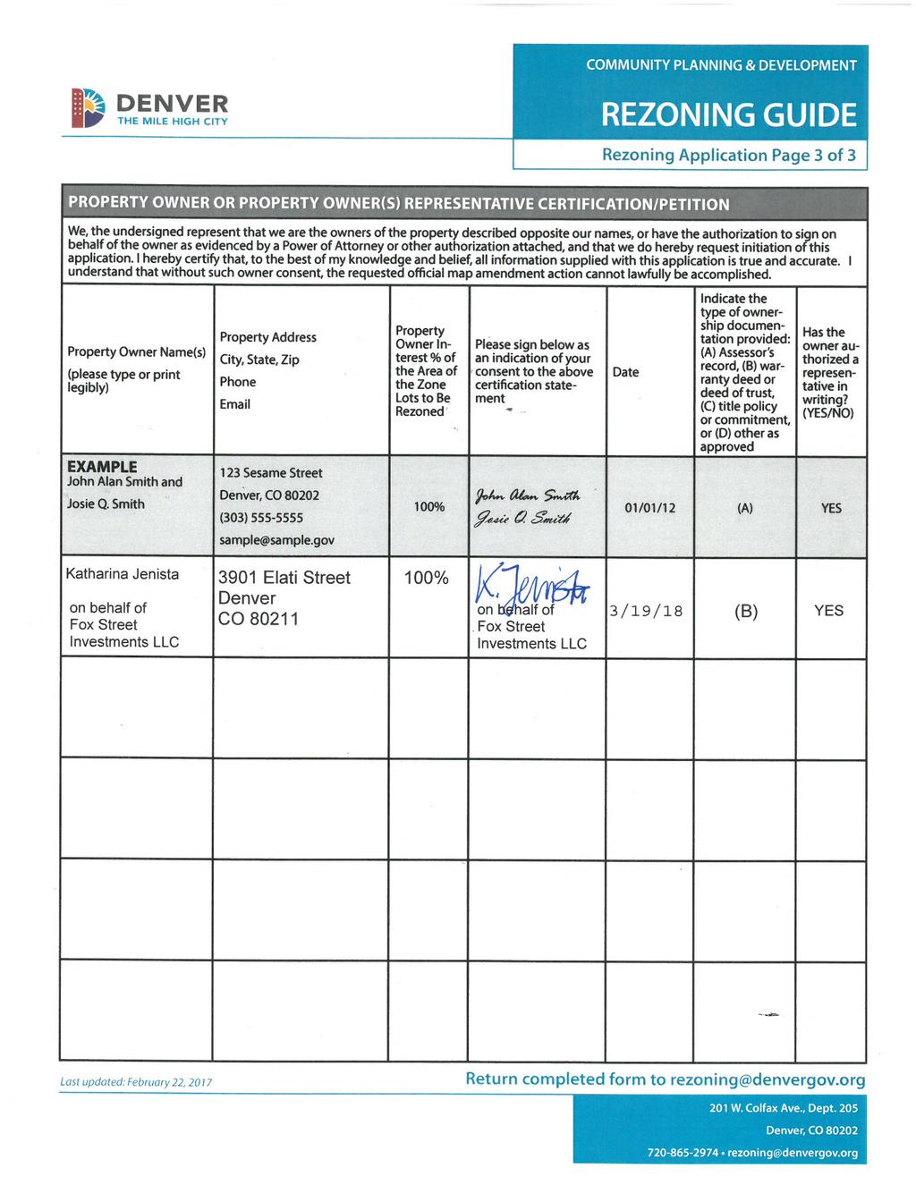
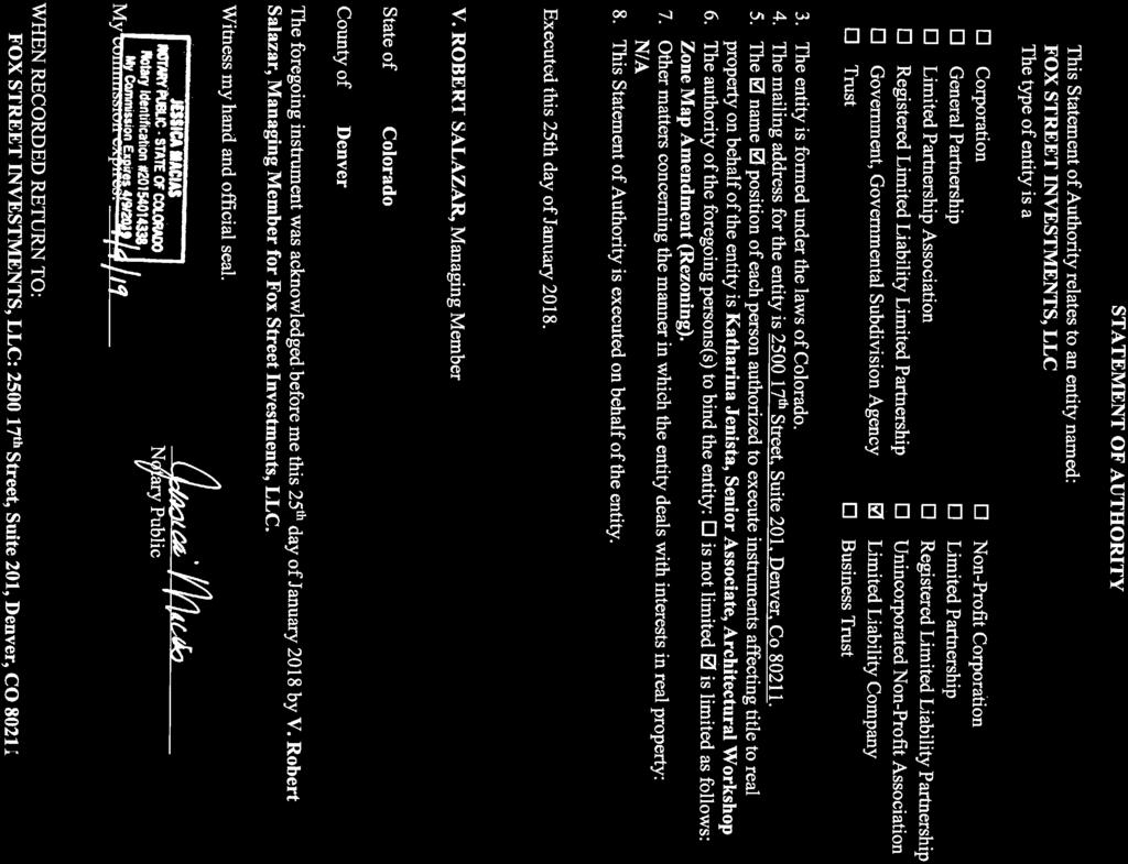
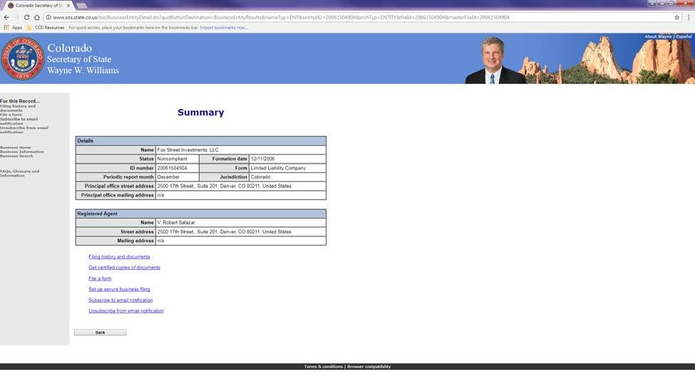
1 Zone Map Amendment (Rezoning) - Application COMMUNITY PLANNING & DEVELOPMENT REZONING GUIDE Rezoning Application Page 1 of 3 PROPERTY OWNER INFORMATION* CHECK IF POINT OF CONTACT FOR APPLICATION Property Owner Name Address City, State, Zip Telephone PROPERTY OWNER(S) REPRESENTATIVE** CHECK IF POINT OF CONTACT FOR APPLICATION Representative Name Address City, State, Zip Telephone *If More Than One Property Owner: All standard zone map amendment applications shall be initiated by all the owners of at least 51% of the total area of the zone lots subject to the rezoning application, or their representatives authorized in writing to do so. See page 3. **Property owner shall provide a written letter authorizing the representative to act on his/her behalf. Please attach Proof of Ownership acceptable to the Manager for each property owner signing the application, such as (a) Assessor s Record, (b) Warranty deed or deed of trust, or (c) Title policy or commitment dated no earlier than 60 days prior to application date. If the owner is a corporate entity, proof of authorization for an individual to sign on behalf of the organization is required. This can include board resolutions authorizing the signer, bylaws, a Statement of Authority, or other legal documents as approved by the City Attorney s Office. SUBJECT PROPERTY INFORMATION Location (address and/or boundary description): Assessor s Parcel Numbers: Area in Acres or Square Feet: Current Zone District(s): PROPOSAL Proposed Zone District: Last updated: February 22, 2017 Return completed form to rezoning@denvergov.org 201 W. Colfax Ave., Dept. 205 Denver, CO rezoning@denvergov.org
2 COMMUNITY PLANNING & DEVELOPMENT REZONING GUIDE Rezoning Application Page 2 of 3 REVIEW CRITERIA Consistency with Adopted Plans: The proposed official map amendment is consistent with the City s adopted plans, or the proposed rezoning is necessary to provide land for a community need that was not anticipated at the time of adoption of the City s Plan. General Review Criteria: The proposal must comply with all of the general review criteria DZC Sec Additional Review Criteria for Non-Legislative Rezonings: The proposal must comply with both of the additional review criteria DZC Sec Please provide an attachment describing relevant adopted plans and how proposed map amendment is consistent with those plan recommendations; or, describe how the map amendment is necessary to provide for an unanticipated community need. Uniformity of District Regulations and Restrictions: The proposed official map amendment results in regulations and restrictions that are uniform for each kind of building throughout each district having the same classification and bearing the same symbol or designation on the official map, but the regulations in one district may differ from those in other districts. Public Health, Safety and General Welfare: The proposed official map amendment furthers the public health, safety, and general welfare of the City. Justifying Circumstances - One of the following circumstances exists: The existing zoning of the land was the result of an error. The existing zoning of the land was based on a mistake of fact. The existing zoning of the land failed to take into account the constraints on development created by the natural characteristics of the land, including, but not limited to, steep slopes, floodplain, unstable soils, and inadequate drainage. The land or its surroundings has changed or is changing to such a degree that it is in the public interest to encourage a redevelopment of the area to recognize the changed character of the area. It is in the public interest to encourage a departure from the existing zoning through application of supplemental zoning regulations that are consistent with the intent and purpose of, and meet the specific criteria stated in, Article 9, Division 9.4 (Overlay Zone Districts), of this Code. Please provide an attachment describing the justifying circumstance. The proposed official map amendment is consistent with the description of the applicable neighborhood context, and with the stated purpose and intent of the proposed Zone District. REQUIRED ATTACHMENTS Please provide an attachment describing how the above criterion is met. Please ensure the following required attachments are submitted with this application: Legal Description (required to be attached in Microsoft Word document format) Proof of Ownership Document(s) Review Criteria ADDITIONAL ATTACHMENTS Please identify any additional attachments provided with this application: Written Authorization to Represent Property Owner(s) Individual Authorization to Sign on Behalf of a Corporate Entity Please list any additional attachments: Last updated: February 22, 2017 Return completed form to rezoning@denvergov.org 201 W. Colfax Ave., Dept. 205 Denver, CO rezoning@denvergov.org
3
4 LEGAL DESCRIPTION 3901 Elati Street, Denver, CO LOTS 16 TO 24, INCLUSIVE, AND THE SOUTH ½ OF LOT 25, BLOCK 39, VIADUCT ADDITION TO DENVER, CITY AND COUNTY OF DENVER, STATE OF COLORADO.
5
6

7
8
9 REVIEW CRITERIA Fox Street Investments LLC (owner) is applying to rezone 3901 N Elati St from I-A to C-MX-20. The parcel on the corner of Elati St and W 39th Ave in the Globeville Neighborhood is currently vacant/used for parking. With the new Light Rail Station on 41 st and Fox Street and the new TOD typology for the area being more of an urban character the current zoning is limited in its future uses for any typical Mixed-Use developments. The current adjacencies in this neighborhood include Industrial, Mixed-Use, Multi-Unit and Single Family Residential. The new proposed zoning will match the general neighborhood development and is consistent with the following General Review Criteria: Consistency with Adopted Plans The proposed zoning of C-MX-20 is consistent with the City s vision for the neighborhood and supported by all adopted plans including Blueprint Denver / Denver Comprehensive Plan, the Globeville Neighborhood Plan (2014) and the 41 st and Fox Station Area Plan (2009). Blueprint Denver: The property is located on North Elati Street in an Area of Change with the Concept Land Use being designated as Transit Oriented Development (TOD). Areas of Change promote development, growth and change. With the new 41 st and Fox light-rail stop being within a quarter mile from the property the proposed new zoning will allow alternative ways to providing housing, services, and employment opportunities for a diverse population in a configuration that facilitates pedestrian and transit access. The new proposed zoning supports Transit Oriented Development with Mixed-Use Office and Residential uses and thus will help create the envisioned change in the adjacency to the transit station served by light rail and bus. Globeville Neighborhood Plan: The Globeville Neighborhood Plan is the most recently adopted plan and confirms the vision for the neighborhood as laid out in Blueprint Denver Transit Oriented Development within an Area of Change. The plan s recommendation #4 calls to improve access to Housing and to improve Neighborhood Services. The new proposed zoning would support and accommodate mid-to-high rise redevelopment with a maximum building height of 20 stories. Transit Oriented Development with Commercial Mixed-Use, and Multifamily Residential Uses will help create the envisioned change in the 41 st and Fox Station Area balancing the needs of Residents, Commerce and Industry. 41 st and Fox Station Area Plan: This plan is focused on the long-term redevelopment of the area east of the railroad tracks to create a complete, transit-friendly neighborhood. The property is designated as Mixed-Use Office/Residential with a building height of 3-20 stories. The proposed new zoning would allow for the promoted higher intensity with a variety of uses including Commercial and Residential. The plan s focal point of a diverse, transit supportive and environmentally sustainable Urban Center will be supported and create opportunities to add more housing, jobs and services to the station area.
10 The new proposed C-MX-20 zone district is consistent with the recommendations of the above referenced adopted plans, would enable growth and allow for mixed-use developments to serve the everyday needs of the neighborhood in adjacency to the new transit station. Uniformity of District Regulations The general purpose of the Mixed-Use zone district is to promote safe, active and pedestrianscaled, diverse areas through the allowed building forms to enhance the convenience, ease and enjoyment of transit, walking, shopping and public gathering within this Urban Center neighborhood. This new proposed zoning will support the vision for this area. The proposed new zoning for this property will result in the uniform application of the Zone District s building form, use and design regulations. Public Health, Safety and General Welfare The proposed official map amendment furthers the public health, safety and general welfare of the City. This amendment will improve an industrial site into a new Mixed-Use development incorporating a variety of uses including new mixed-income housing and commercial spaces. The rezoning and future development of this site will contribute to the creation of a safer improved road and pedestrian sidewalk network for existing and future area residents. The new light rail station will provide easy access to downtown and reduce the need for automotive transportation. The development of this parcel will likely encourage more substantial investment to rehabilitate the property with a useful life for the community by allowing for more local businesses to continue the existing surrounding development structures. Justifying Circumstances The land or its surrounding has changed or is changing to such a degree that it is in the public interest to encourage a redevelopment of the area to recognize the changed character of the area. Changes include newer adopted neighborhood plans, recent rezoning and development of other properties in the areas and the new light rail station. The above referenced section of the DZC applies to this parcel with the existing zoning no longer being appropriate for this site. It is in the public interest to match the surrounding zoning recognizing the changed character of the area. Consistency with Neighborhood Context Description, Zone District Purpose and Intent Statements The requested C-MX-20 zone district is within the Urban Neighborhood Context. The Mixed-Use districts are intended to promote active, pedestrian-scaled and divers areas and activate the public street edge. The district standards also intend to enhance the neighborhood and ensure new development that contributes positively to the established character. The proposed rezoning is consistent with the Urban Center context. Given the proximity to transit and the mixed-use arterial Fox Street the proposed rezoning will achieve the intent of the zone district. Please see enclosed supporting documentation of the surrounding area.

11 CURRENT ZONING IN THE SURROUNDING AREA: 3901 N Elati St recently re-zoned: C-MX-20 recently re-zoned: C-RX-12 current zoning: I-A, UO-2 current zoning: I-B, UO-2 recently re-zoned: C-MS-12

12 RECENTLY RE-ZONED IN THE SURROUNDING AREA:


13 RECENTLY RE-ZONED DEVELOPMENTS IN THE SURROUNDING AREA: FOX STREET STATION FOX STREET SHOPS


14 RECENTLY RE-ZONED DEVELOPMENTS IN THE SURROUNDING AREA: THE VILLAS AT THE REGENCY - STUDENT HOUSING

15 REZONING APPLICATIONS IN THE SURROUNDING AREA:
16 REVIEW CRITERIA Fox Street Investments LLC (Applicant) is applying to rezone 3901 N Elati St from I-A to C-MX- 20. The existing UO-2 Bilboard Use Overlay will be removed from the property with this rezoning. The parcel on the corner of Elati St and W 39th Ave in the Globeville Neighborhood is currently vacant/used for parking. With the new Light Rail Station on 41 st and Fox Street and the new TOD typology for the area being more of an urban character, the current I-A zoning is limited in its future uses for any typical Mixed-Use developments. The current adjacencies in this neighborhood include Industrial, Mixed-Use, Multi-Unit and Single Family Residential. The new proposed zoning will match the general neighborhood development and is consistent with the following General Review Criteria: Consistency with Adopted Plans The proposed zoning of C-MX-20 is consistent with the City s vision for the neighborhood and supported by all City and County of Denver adopted plans. These following Plans apply to the subject property: Denver Comprehensive Plan 2000 Blueprint Denver Globeville Neighborhood Plan (2014) 41 st and Fox Station Area Plan (2009) Comprehensive Plan 2000 The proposed new zoning of the subject property is consistent with intent of the Denver Comprehensive Plan strategies. A number of specific alignments with the Comprehensive Plan Objectives and Strategies that would provide value to the public interest include the following: Land use strategy 3-B Encourage quality infill development that is consistent with character of the surrounding neighborhood; that offers opportunities for increased density and more amenities; and that broadens the variety of compatible uses. Land User Strategy 4A Encourage mixed-use, transit-oriented development that makes effective use of existing transportation infrastructure, supports transit stations, increases transit patronage, reduces impact on the environment, and encourages vibrant urban centers and neighborhoods. Mobility Strategy 3-B Promote transit-oriented development (TOD) as an urban design framework for urban centers and development area. Development as transit stations should provide both higher ridership to the transit system and viability and walkability in the area. Mobility Strategy 4-E Continue to promote mixed-use development, which enables people to live near work, retail and services.
17 The proposed rezoning will enable the continued development opportunity of mixed-use development at the 41 st street station where services and infrastructure are already under development. The C-MX-20 will allow high-intensity development immediately adjacent to the transit station as well as alignment with existing 18 story student housing facility. The rezoning is consistent with the Denver Comprehensive Plan. Blueprint Denver: The property is located on North Elati Street in an Area of Change with the Concept Land Use being designated as Transit Oriented Development (TOD). Areas of Change promote development, growth and change. With the new 41 st and Fox light-rail stop being within a quarter mile from the property the proposed new zoning will allow alternative ways to providing housing, services, and employment opportunities for a diverse population in a configuration that facilitates pedestrian and transit access. The new proposed zoning supports Transit Oriented Development with Mixed-Use Office and Residential uses and thus will help create the envisioned change in the adjacency to the transit station served by light rail and bus. Globeville Neighborhood Plan: The Globeville Neighborhood Plan is the most recently adopted plan and confirms the vision for the neighborhood as laid out in Blueprint Denver Transit Oriented Development (TOD) within an Area of Change. The plan s recommendation #4 calls to improve access to Housing and to improve Neighborhood Services. The new proposed zoning would support and accommodate mid-to-high rise redevelopment with a maximum building height of 20 stories. Transit Oriented Development with Commercial Mixed-Use, and Multifamily Residential Uses will help create the envisioned change in the 41 st and Fox Station Area balancing the needs of Residents, Commerce and Industry. 41 st and Fox Station Area Plan: This plan is focused on the long-term redevelopment of the area east of the railroad tracks to create a complete, transit-friendly neighborhood. The property is designated as Mixed-Use Office/Residential with a building height of 3-20 stories. The proposed new zoning would allow for the promoted higher intensity with a variety of uses including Commercial and Residential. The plan s focal point of a diverse, transit supportive and environmentally sustainable Urban Center will be supported and create opportunities to add more housing, jobs and services to the station area. The new proposed C-MX-20 zone district is consistent with the recommendations of the above referenced adopted plans, would enable growth and allow for mixed-use developments to serve the everyday needs of the neighborhood in adjacency to the new transit station. Uniformity of District Regulations The general purpose of the Mixed-Use zone district is to promote safe, active and pedestrianscaled, diverse areas through the allowed building forms to enhance the convenience, ease and
18 enjoyment of transit, walking, shopping and public gathering within this Urban Center neighborhood. This new proposed zoning will support the vision for this area. The proposed new zoning for this property will result in the uniform application of the Zone District s building form, use and design regulations. Public Health, Safety and General Welfare The proposed official map amendment furthers the public health, safety and general welfare of the City. This amendment will improve an industrial site into a new Mixed-Use development incorporating a variety of uses including new mixed-income housing and commercial spaces. The rezoning and future development of this site will contribute to the creation of a safer improved road and pedestrian sidewalk network for existing and future area residents. The new light rail station will provide easy access to downtown and reduce the need for automotive transportation. The development of this parcel will likely encourage more substantial investment to rehabilitate the property with a useful life for the community by allowing for more local businesses to continue the existing surrounding development structures. Justifying Circumstances The land or its surrounding has changed or is changing to such a degree that it is in the public interest to encourage a redevelopment of the area to recognize the changed character of the area. Changes include newer adopted neighborhood plans, recent rezoning and development of other properties in the areas and the new light rail station. The above referenced section of the DZC applies to this parcel with the existing zoning no longer being appropriate for this site. It is in the public interest to match the surrounding zoning recognizing the changed character of the area. Also addressed are the new Denver City Council adopted changes to the Denver Zoning Code, including modifications to the Justifying Circumstances language in section A. Denver City Council adopted changes On May 21, 2018 the Denver City Council adopted changes to the Denver Zoning Code, including modifications to the Justifying Circumstances language in section A. After review of the adopted language, the Applicant believes the rezoning is justified under sections A.4a and A.4B for the following reasons: 4a) states a changing condition to such a degree that the proposed rezoning is in the public interest. The opening of the Gold Line light rail station at 41 st in conjunction with recent developments at 3900 Elati Regency Student Housing as well at the 38 th and Fox street commercial developments warrants rezoning to the subject property. 4b) states A City adopted plan. In 2014, the Globeville Neighborhood Plan was adopted in which the subject property is suggested as mixed use development with a maximum height of 20 stories which is consistent with the C-MX-20 zoning that is requested and believed to be optimum zoning for the public interest.
19 For this reason and as stated above, the subject project is being submitted for rezoning to C- MX-20 in alignment with the City of Denver Globeville Neighborhood Plan (2014). Consistency with Neighborhood Context Description, Zone District Purpose and Intent Statements The requested C-MX-20 zone district is within the Urban Neighborhood Context. The Mixed-Use districts are intended to promote active, pedestrian-scaled and divers areas and activate the public street edge. The district standards also intend to enhance the neighborhood and ensure new development that contributes positively to the established character. The proposed rezoning is consistent with the Urban Center context. Given the proximity to transit and the mixed-use arterial Fox Street the proposed rezoning will achieve the intent of the zone district. Please see enclosed supporting documentation of the surrounding area.
September 25th, 2018 $2000 fee pd CC
 2.7267 acres 2018I-00075 September 25th, 2018 $2000 fee pd CC Rezoning Review Criteria Analysis - Map Amendment Application Number: 2018I-00075 805 W. 38 th Avenue October 19, 2018 (amd.) September 17,
Staff Report and Recommendation
 Community Planning and Development Planning Services 201 W. Colfax Ave., Dept. 205 Denver, CO 80202 p: 720.865.2915 f: 720.865.3052 www.denvergov.org/cpd TO: City Council Neighborhoods and Planning Committee
REZONING GUIDE. Zone Map Amendment (Rezoning) - Application. Rezoning Application Page 1 of 3. Return completed form to
 - Application. Rezoning Application Page 1 of 3. Return completed form to") Zone Map Amendment (Rezoning) - Application COMMUNITY PLANNING & DEVELOPMENT REZONING GUIDE Rezoning Application Page 1 of 3 PROPERTY OWNER INFORMATION* CHECK IF POINT OF CONTACT FOR APPLICATION Property
Zone Map Amendment (Rezoning) - Application COMMUNITY PLANNING & DEVELOPMENT REZONING GUIDE Rezoning Application Page 1 of 3 PROPERTY OWNER INFORMATION* CHECK IF POINT OF CONTACT FOR APPLICATION Property
Official Zoning Map Amendment Application #2018I-00047
 Community Planning and Development Planning Services 201 W. Colfax Ave., Dept. 205 Denver, CO 80202 p: 720.865.2915 f: 720.865.3052 www.denvergov.org/cpd TO: Denver Planning Board FROM: Chandler Van Schaack,
Official Zoning Map Amendment Application #2018I-00077
 Community Planning and Development Planning Services 201 W. Colfax Ave., Dept. 205 Denver, CO 80202 p: 720.865.2915 f: 720.865.3052 www.denvergov.org/cpd TO: Denver Planning Board FROM: Scott Robinson,
Official Zoning Map Amendment Application #2018I-00075
 Community Planning and Development Planning Services 201 W. Colfax Ave., Dept. 205 Denver, CO 80202 p: 720.865.2915 f: 720.865.3052 www.denvergov.org/cpd TO: Denver Planning Board FROM: Scott Robinson,
Planning Services Community Planning and Development 201 W. Colfax Ave., Dept. 205 Denver, CO p
 TO: Denver Planning Board, Julie Underdahl, Chair FROM: Theresa Lucero, Senior City Planner DATE: RE: Official Zoning Map Amendment Application #2017I-00042 Staff Report and Recommendation Based on the
TO: Staff Report and Recommendation
 Community Planning and Development Planning Services 201 W. Colfax Ave., Dept. 205 Denver, CO 80202 p: 720.865.2915 f: 720.865.3052 www.denvergov.org/cpd TO: City Council Neighborhoods and Planning Committee
, C-MS I June 3, 2016 $1500 pd chk #216918
 , C-MS-8 LOTS 21 THROUGH 40, INCLUSIVE, BLOCK 299 CLEMENTS ADDITION TO THE CITY OF DENVER SOUTHEAST QUARTER OF SECTION 34, TOWNSHIP 3 SOUTH, RANGE 68 WEST, SIXTH PRINCIPAL MERIDIAN, CITY
Denver Land Use, Transportation and Infrastructure Committee FROM: Andrew Webb, Senior City Planner DATE: March 22, 2018 RE:
 Community Planning and Development Planning Services 201 W. Colfax Ave., Dept. 205 Denver, CO 80202 p: 720.865.2915 f: 720.865.3052 www.denvergov.org/cpd TO: Denver Land Use, Transportation and Infrastructure
Staff Report and Recommendation
 Community Planning and Development Planning Services 201 W Colfax Ave, Dept 205 Denver, CO 80202 p: 720-865-2972 f: 720-865-3056 www.denvergov.org/planning TO: LUTI FROM: Steve Nalley, Senior City Planner
Staff Report and Recommendation Based on the criteria for review in the Denver Zoning Code, Staff recommends approval for Application #2018I
 Community Planning and Development Planning Services 201 W. Colfax Ave., Dept. 205 Denver, CO 80202 p: 720.865.2915 f: 720.865.3052 www.denvergov.org/cpd TO: Denver Planning Board FROM: Sara White, AICP,
2 nd & St Paul, LLC and BAH-PLA, LLC
 Community Planning and Development Planning Services 201 W. Colfax Ave., Dept. 205 Denver, CO 80202 p: 720.865.2915 f: 720.865.3052 www.denvergov.org/cpd TO: Denver City Council FROM: Theresa Lucero, Senior
To: S-MX-8 AIO, S-MX-8A AIO, S-MX-12 AIO, C-MX-8 AIO, C-MX-12 AIO, and S-CC-5 AIO
 Community Planning and Development Planning Services 201 W. Colfax Ave., Dept. 205 Denver, CO 80202 p: 720.865.2915 f: 720.865.3052 www.denvergov.org/cpd TO: City Council Neighborhoods and Planning Committee
TO: Denver Planning Board FROM: Analiese Hock, Senior City Planner DATE: March 13, 2018 RE:
 Community Planning and Development Planning Services 201 W. Colfax Ave., Dept. 205 Denver, CO 80202 p: 720.865.2915 f: 720.865.3052 www.denvergov.org/cpd TO: Denver Planning Board FROM: Analiese Hock,
Staff Report and Recommendation Based on the criteria for review in the Denver Zoning Code, Staff recommends approval for Application #2017I
 TO: Denver City Council Land Use, Transportation and Infrastructure Committee FROM: Theresa Lucero, Senior City Planner DATE: RE: Official Zoning Map Amendment Application #2017I-00149 Staff Report and
#2017I E-RH-2.5 Highland Ventures Holdings, LLC and Irving Estates, LLC
 TO: Denver Planning Board - Joel Noble, Chair FROM: Theresa Lucero, Senior City Planner DATE: RE: Official Zoning Map Amendment Application #2017I-00178 1080 and 1090 King Street Rezoning from E-SU-D1x
DENVER DESIGN DISTRICT GDP
 DENVER DESIGN DISTRICT GDP Urban Design Standards and Guidelines November 17, 2008 Amended February 3, 2016 City and County of Denver CF Property Management, Inc. C/O Denver Design District - Starboard
178 Carruthers Properties Inc.
 178 Carruthers Properties Inc. Planning Rationale for 178 Carruthers Avenue Site Plan Control Application June 2014 Table of Contents 1.0 Introduction 2.0 Overview of Subject Property 3.0 Current Zoning
Chapter 1.0 Introduction
 Chapter 1.0 Introduction 1.1 Background The North Metro commuter rail line is part of the RTD FasTracks regional transit system expansion program to build more than 100 miles of rail transit throughout
CITY OF PUYALLUP. Background. Development Services
 CITY OF PUYALLUP Development Services 333 South Meridian Puyallup WA 98371 To: City Council From: Katie Baker, AICP, Planning Division Re: South Hill Neighborhood Plan Adoption Date: (Meeting date: February
ORDINANCE WHEREAS, this Ordinance is consistent with the City of Winter Garden Comprehensive Plan; and
 ORDINANCE 17-06 AN ORDINANCE OF THE CITY COMMISSION OF THE CITY OF WINTER GARDEN, FLORIDA, CREATING ARTICLE XIV OF CHAPTER 118 OF THE CITY OF WINTER GARDEN CODE OF ORDINANCES PROVIDING FOR THE EAST PLANT
POLICY AMENDMENT AND LAND USE AMENDMENT TUXEDO PARK (WARD 9) CENTRE STREET N AND 26 AVENUE NE BYLAWS 36P2017 AND 234D2017
 CENTRE STREET N AND 26 AVENUE NE BYLAWS 36P2017 AND 234D2017") Page 1 of 11 EXECUTIVE SUMMARY This application proposes to redesignate a single parcel of land in the Community of Tuxedo Park from Commercial Corridor 2 (C-COR2 f1h10) District to Mixed Use Active Frontage
Page 1 of 11 EXECUTIVE SUMMARY This application proposes to redesignate a single parcel of land in the Community of Tuxedo Park from Commercial Corridor 2 (C-COR2 f1h10) District to Mixed Use Active Frontage
2040 LUP is a part of the Comprehensive Plan and carries the same legal authority. Economic Challenges
 1.1. Guiding Anchorage s Growth Where will new residents settle over the next two decades? Where will people work, shop, and play? Will there be enough room to grow? How will Anchorage look? Will growth
EXHIBIT A. Tax Increment Reinvestment Zone No. 1 (Town Center) First Amended Project Plan 1
 First Amended Project Plan 1") EXHIBIT A Tax Increment Reinvestment Zone No. 1 (Town Center) First Amended Project Plan 1 1 As amended by Resolution No. 2008-02-001(TR1R) of the Tax Increment Reinvestment Zone No.1, and approved to
EXHIBIT A Tax Increment Reinvestment Zone No. 1 (Town Center) First Amended Project Plan 1 1 As amended by Resolution No. 2008-02-001(TR1R) of the Tax Increment Reinvestment Zone No.1, and approved to
EXISTING COMPREHENSIVE PLAN
 EXISTING COMPREHENSIVE PLAN Town Center Land Use Element: V. LAND USE POLICIES Town Center Mercer Island's business district vision as described in "Your Mercer Island Citizen-Designed Downtown" was an
17.11 Establishment of Land Use Districts
 17.11 Establishment of Land Use Districts 17.11.010 Purpose. To promote the health, safety, and general welfare of City residents and those who come to South Salt Lake to work, exchange commerce and recreate.
CITY OF COLWICH COMPREHENSIVE PLAN LAND USE LAND USE 1
 LAND USE LAND USE 1 WHAT YOU WILL FIND IN THIS CHAPTER: Discussion of today s conditions and tomorrow s projections Discussion of challenges and opportunities Discussion of the environmental quality goals,
LAND USE DESIGNATIONS AND ZONING CLASSIFICATIONS
 LAND USE DESIGNATIONS AND ZONING CLASSIFICATIONS One of the most significant issues addressed within the community plan process is land use. How land is utilized within a community directly affects the
Tyvola & Archdale Transit Station Area Plan. May 15, 2008
 Tyvola & Archdale Transit Station Area Plan First Public Meeting May 15, 2008 Presentation Outline 1. Purpose and Process 2. Station Area Overview 3. Plan Recommendations Vision Land Use Transportation
SUMMERSIDE / MT. CARMEL REINVESTMENT CORRIDOR COMMUNITY DEVELOPMENT STRATEGY
 SUMMERSIDE / MT. CARMEL REINVESTMENT CORRIDOR COMMUNITY DEVELOPMENT STRATEGY FEBRUARY 2013 I. Location of the Summerside/Mt. Carmel Reinvestment Corridor The Summerside/Mt. Carmel Reinvestment Corridor
LEED-ND 101: Practical Strategies for Achieving Sustainability Goals. Travis Parker Lakewood Planning Director
 LEED-ND 101: Practical Strategies for Achieving Sustainability Goals Travis Parker Lakewood Planning Director Metro Vision Idea Exchange Oct 11, 2012 West Corridor Stations West Corridor Overview West
POLICY AMENDMENT AND LAND USE AMENDMENT KILLARNEY/GLENGARRY (WARD 8) NW CORNER OF RICHMOND ROAD AND 33 STREET SW BYLAWS 1P2015 AND 7D2015
 NW CORNER OF RICHMOND ROAD AND 33 STREET SW BYLAWS 1P2015 AND 7D2015") Page 1 of 13 EXECUTIVE SUMMARY This application seeks to redesignate an RC-2 (Residential Contextual One/Two Dwelling) parcel to MC-Gd72 (Multi-Residential Contextual Grade-Oriented) to allow for multi-residential
Page 1 of 13 EXECUTIVE SUMMARY This application seeks to redesignate an RC-2 (Residential Contextual One/Two Dwelling) parcel to MC-Gd72 (Multi-Residential Contextual Grade-Oriented) to allow for multi-residential
DRAFT Land Use Chapter
 Stevens Creek Urban Village DRAFT 1 18 17 Land Use Chapter INTRODUCTION This Land Use Chapter describes how the Stevens Creek Urban Village will accommodate the growth that is planned for it in the Envision
City Of Sparks Planning Commission Item
 Page 1 of 12 City Of Sparks Planning Commission Item Meeting Date: May17, 2012 Subject: PCN12009, Public Hearing, Consideration and possible action on a Master Plan Amendment and Rezoning request to change
Staff Report and Recommendation
 Community Planning and Development Planning Services 201 W. Colfax Ave., Dept. 205 Denver, CO 80202 p: 720.865.2915 f: 720.865.3052 www.denvergov.org/cpd TO: Denver City Council FROM: Steve Nalley, Neighborhood
ALBEMARLE COUNTY CODE CHAPTER 18 ZONING SECTION 20A NEIGHBORHOOD MODEL - NMD
 CHAPTER 18 ZONING SECTION 20A NEIGHBORHOOD MODEL - NMD Sections: 20A.1 PURPOSE AND INTENT 20A.2 STATUS AS A PLANNED DEVELOPMENT DISTRICT 20A.5 CODES OF DEVELOPMENT 20A.6 PERMITTED USES 20A.7 RESIDENTIAL
NEC of Central Avenue and Indian School Road
 NEC of Central Avenue and Indian School Road For this location, there are two applicable plans that provide guidance on development. The two plans include the Indian School Specific Plan (1991) and the
Staff Report to the North Ogden City Planning Commission
 Staff Report to the North Ogden City Planning Commission SYNOPSIS / APPLICATION INFORMATION Application Request: Concept review on a legislative application to rezone land located at approximately 1750
Steering Committee Meeting
 Neighborhood Planning Initiative NPI EAST CENTRAL AREA PLAN Steering Committee Meeting November 9, 2017 6:00PM 8:00PM Tears McFarlane House East Central Area Plan Steering Committee Meeting 11/9/17 AGENDA
The University District envisions, in its neighborhood
 Envisioning the University District Link Light Rail in Seattle s neighborhoods CIY OF SEALE CONCEP-LEVEL SAION AREA PLANNING RECOMMENDAION RESOLUION # 30165 EXHIBI L Vision 08.2000 he University District
The Five Components of the McLoughlin Area Plan
 The Five Components of the McLoughlin Area Plan This documents contains the complete language of the five components of the McLoughlin Area Plan: The Vision Statement The Values The Guiding Principles
A Growing Community Rural Settlement Areas
 Town of Huntsville Official Plan Review - POLICY BACKGROUND PAPER A Growing Community Rural Settlement Areas BACKGROUND: In addition to the fully municipally-serviced Urban Settlement Area and the Hidden
2.0 THE PLATINUM TRIANGLE VISION
 2.0 THE PLATINUM TRIANGLE VISION The envisions an exciting future for the area surrounding Angel Stadium of Anaheim, the Honda Center and The Grove of Anaheim. 2.1 Planning Principles In order to further
4.1.3 LAND USE CATEGORIES
 4.1.3 LAND USE CATEGORIES a. City Center District The City Center District incorporates the existing character and mix of uses in downtown Belmont to encourage redevelopment and new development in keeping
Land Use Amendment in Southwood (Ward 11) at and Elbow Drive SW, LOC
 at and Elbow Drive SW, LOC") 2018 November 15 Page 1 of 10 EXECUTIVE SUMMARY This land use amendment application was submitted by Rick Balbi Architect on 2017 August 31 on behalf of Sable Developments Ltd, and with authorization from
2018 November 15 Page 1 of 10 EXECUTIVE SUMMARY This land use amendment application was submitted by Rick Balbi Architect on 2017 August 31 on behalf of Sable Developments Ltd, and with authorization from
ARTICLE 6: Special and Planned Development Districts
 ARTICLE 6: Special and Planned Development Districts 6-10 Traditional Neighborhood Development (TND) District 6-10.10 Purpose and Intent The Traditional Neighborhood Development (TND) District provides
CHAPTER 1. Ms. Guajardo s Class - Central Elementary CH 1 1
 INTRODUCTION CHAPTER 1 Ms. Guajardo s Class - Central Elementary CH 1 1 1.1 SETTING South Centre City is a linear corridor south of Downtown Escondido paralleling Centre City Parkway and South Escondido
VILLAGE OF CLEMMONS PLANNING BOARD DRAFT STAFF REPORT
 VILLAGE OF CLEMMONS PLANNING BOARD DRAFT STAFF REPORT PETITION INFORMATION Docket # C-226 Staff Megan Ledbetter Petitioner(s) JBJH Properties, LLC Owner(s) JBJH Properties, LLC Subject Property 5892-49-1766
FUTURE LAND USE ELEMENT
 FUTURE LAND USE ELEMENT GOAL I: To create and sustain a great place to live, play, and prosper Objective 1: The City of Ocala shall incorporate the principles and strategies of the Ocala 2035 Vision into
Tyvola & Archdale Transit Station Area Plan. June 5, 2008
 Tyvola & Archdale Transit Station Area Plan Second Public Meeting June 5, 2008 Presentation Outline 1. Purpose and Process 2. Station Area Overview 3. Plan Recommendations 4. Comments Received and Proposed
Urban Design Manual PLANNING AROUND RAPID TRANSIT STATIONS (PARTS) Introduction. Station Study Areas
 Introduction. Station Study Areas") 111111 PLANNING AROUND RAPID TRANSIT STATIONS (PARTS) Introduction The ION rapid transit system will link Waterloo, Kitchener and Cambridge through a central transit corridor (CTC). There are a number
111111 PLANNING AROUND RAPID TRANSIT STATIONS (PARTS) Introduction The ION rapid transit system will link Waterloo, Kitchener and Cambridge through a central transit corridor (CTC). There are a number
Figure 1- Site Plan Concept
 Figure 1- Site Plan Concept Parking will be provided underground on three levels at rate of 1.0 space/ unit; this rate includes all visitors parking. MMM Group has prepared a parking assessment (April,
COMMUNITY DESIGN. GOAL: Create livable and attractive communities. Intent
 COMMUNITY DESIGN Intent An attractive, well-designed County will attract quality development, instill civic pride, improve the visual character of the community, and create a strong, positive image for
LAND USE AMENDMENT CORNERSTONE (WARD 3) 60 STREET NE AND COUNTRY HILLS BOULEVARD NE MAP 26NE BYLAW 22D2017
 60 STREET NE AND COUNTRY HILLS BOULEVARD NE MAP 26NE BYLAW 22D2017") Page 1 of 14 EXECUTIVE SUMMARY This Land Use Amendment application covers an area of 43.76 hectares ± (108.14 acres ±) located in northeast Calgary, bound by Country Hills Boulevard NE to the south and
Page 1 of 14 EXECUTIVE SUMMARY This Land Use Amendment application covers an area of 43.76 hectares ± (108.14 acres ±) located in northeast Calgary, bound by Country Hills Boulevard NE to the south and
Public may provide comments on the GDP within the next two weeks (December 24)
") 25/70 General Development Plan (GDP) Public Meeting Wednesday, December 10, 2014 6:00 8:00 P.M. District 1 Police Station Community Room 1311 W 46th Ave, Denver, CO 80211 Council Woman Montero: This particular
25/70 General Development Plan (GDP) Public Meeting Wednesday, December 10, 2014 6:00 8:00 P.M. District 1 Police Station Community Room 1311 W 46th Ave, Denver, CO 80211 Council Woman Montero: This particular
Lynn Housing Authority and Neighborhood Development. Washington Street Gateway District Plan A p r i l
 Lynn Housing Authority and Neighborhood Development Washington Street Gateway District Plan A p r i l 2 0 0 8 rendering of sagamore hill from lynnway pedestrian overpass table of contents project area
CONSENT CALENDAR CITY PLANNING COMMISSION AGENDA ITEM NO: A.1, A.2 STAFF: LARRY LARSEN
 Page 8 CONSENT CALENDAR CITY PLANNING COMMISSION AGENDA ITEM NO: A.1, A.2 STAFF: LARRY LARSEN FILE NO: CPC PUZ 14-00013 - QUASI-JUDICIAL FILE NO: CPC PUD 14-00014 QUASI-JUDICIAL PROJECT: APPLICANT: OWNER:
SPECIFIC PLAN Requirements
 CITY OF LANCASTER PLANNING DEPARTMENT 44933 Fern Avenue, Lancaster, California 93534 (661) 723-6100 SPECIFIC PLAN Requirements Purpose The purpose of a specific plan is to provide for the logical development
Applicant Name Phone / Fax / Address City State Zip Code . Property Owner Phone / Fax / Address City State Zip Code
 Master Development Plan Application Community Development Department City of Redmond 411 SW 9 th Street Redmond, Oregon 97756 541-923-7721 541-548-0706 FAX Master Development Plan Fee $38,862.52 File Number
IMPLEMENTATION STRATEGIES. In This Chapter. Goals & Strategies 182 Project List 183 Future Land Use 186 CHAPTER 11 IMPLEMENTATION STRATEGIES
 In This Chapter Goals & Strategies 182 Project List 183 Future Land Use 186 11 IMPLEMENTATION STRATEGIES NORTH AUGUSTA, SC 2017 COMPREHENSIVE PLAN 179 Individual commitment to a group effort that is what
Commercial Development Standards. City of Homestead
 Commercial Development Standards City of Homestead Presentation Outline Introductions Purpose and Intent Objectives Administrative Process Established Districts Design Standards Purpose and Intent Supplement
Planning Commission April 4, 2013 BOCC Workshop Page 1
 Planning Commission April 4, 2013 BOCC Workshop Page 1 Planning Commission April 4, 2013 BOCC Workshop Page 2 Planning Commission April 4, 2013 BOCC Workshop Page 3 Planning Commission April 4, 2013 BOCC
COLVER ROAD INDUSTRIAL CONCEPT PLAN
 COLVER ROAD INDUSTRIAL CONCEPT PLAN A CONCEPTUAL LAND USE AND TRANSPORTATION PLAN FOR TA-4 AN URBAN RESERVE AREA OF THE CITY TALENT City of Talent Adopted by City Council Resolution No., June, 2015 PART
Living in Albemarle County s Urban Places
 Living in Albemarle County s Urban Places ALBEMARLE COUNTY, VIRGINIA A Closer Look at Albemarle s Approach to Managing Growth and Creating Quality Urban Environments www.albemarle.org Page 2 Living in
SECTION II SECTION II STATEMENT OF GOALS, OBJECTIVES, PRINCIPLES, ASSUMPTIONS, POLICIES AND STANDARDS
 STATEMENT OF GOALS, OBJECTIVES, PRINCIPLES, ASSUMPTIONS, POLICIES AND STANDARDS 1 2 STATEMENT OF GOALS, OBJECTIVES, PRINCIPLES, ASSUMPTIONS, POLICIES AND STANDARDS INTRODUCTION The New Jersey Municipal
Danvers High Street I-1 District Study
 Danvers High Street I-1 District Study Presentation of Final Recommendations Planning Board Presentation June 26 th, 2018 1 Introductions Metropolitan Area Planning Council Sam Cleaves AICP, Principal
Isabel Neighborhood Plan: Alternatives
 Isabel Neighborhood Plan: Alternatives Presented by: Lori Parks, Associate Planner February 2, 2015 Agenda 1. Background on BART to Livermore 2. Isabel Neighborhood Plan 3. Alternative Scenarios 4. General
Subregion 4 Central Avenue-Metro Blue Line Corridor Transit-Oriented Development (TOD) Implementation Project. Community Meeting April 27, 2011
 Implementation Project. Community Meeting April 27, 2011") Subregion 4 Central Avenue-Metro Blue Line Corridor Transit-Oriented Development (TOD) Implementation Project Community Meeting April 27, 2011 Overview Introduction to Subregion 4 TOD Implementation Program
Subregion 4 Central Avenue-Metro Blue Line Corridor Transit-Oriented Development (TOD) Implementation Project Community Meeting April 27, 2011 Overview Introduction to Subregion 4 TOD Implementation Program
Official Zoning Map Amendment Application #2018I-00131
 Community Planning and Development Planning Services 201 W. Colfax Ave., Dept. 205 Denver, CO 80202 p: 720.865.2915 f: 720.865.3052 www.denvergov.org/cpd TO: Denver Planning Board FROM: Kristofer Johnson,
Gold Line Bus Rapid Transit Transit Oriented Development (BRTOD) Helmo Station Area Plan
 Helmo Station Area Plan") Appendix F Gold Line Bus Rapid Transit Transit Oriented Development (BRTOD) Helmo Station Area Plan Introduction and Purpose of the Plan The Gold Line Bus Rapid Transit facility is an eleven-mile dedicated
Appendix F Gold Line Bus Rapid Transit Transit Oriented Development (BRTOD) Helmo Station Area Plan Introduction and Purpose of the Plan The Gold Line Bus Rapid Transit facility is an eleven-mile dedicated
ELMVALE ACRES SHOPPING CENTRE MASTER PLAN
 ELMVALE ACRES SHOPPING CENTRE MASTER PLAN Contents 1.0 INTRODUCTION... 2 2.0 LOCATION... 2 3.0 EXISTING CONTEXT... 2 4.0 VISION & GUIDING PRINCIPLES... 2 5.0 LAND USE AND BUILT FORM... 4 5.1 St. Laurent
Moody Centre Station TOD Area Today
 Moody Centre Station TOD Area Today WHAT IS a transit-oriented Murray Street development area? A Transit-Oriented Development (TOD) Area is a dense, walkable residential and commercial area built to support
D-O LRT Zoning Discussion. Chapel Hill Boards & Commissions October 16, 2017
 D-O LRT Zoning Discussion Chapel Hill Boards & Commissions October 16, 2017 Update on Overall D-O LRT Station Area Initiative Objectives Design and educate on principles of Good Transit-Oriented Development
NEW CASTLE COUNTY S ZONING DISTRICTS
 NEW CASTLE COUNTY S ZONING DISTRICTS This is general information about New Castle County s zoning districts. The information included is by no means exhaustive or complete. Before designing plans to develop
Blueprint Denver A BLUEPRINT FOR AN INCLUSIVE CITY. Executive Summary
 Blueprint Denver A BLUEPRINT FOR AN INCLUSIVE CITY Executive Summary PUBLIC REVIEW DRAFT 2 1/7/2019 DENVERIGHT BLUEPRINTDENVER Blueprint Denver: A Blueprint for an Inclusive City An Equitable City Planning
Sheridan Boulevard S TAT I O N A R E A P L A N S H E R I D A N B O U L E VA R D S TAT I O N A R E A P L A N
 Sheridan Boulevard S TAT I O N A R E A P L A N 1 City of Lakewood Adopted November, 2006 S H E R I D A N B O U L E VA R D S TAT I O N A R E A P L A N The Vision The City of Lakewood s overall vision is
MOUNT BAKER TOWN CENTER: THE 2014 REZONE AND TRANSIT ORIENTED DEVELOPMENT. By Talis Abolins
 MOUNT BAKER TOWN CENTER: THE 2014 REZONE AND TRANSIT ORIENTED DEVELOPMENT By Talis Abolins In 2014, the City of Seattle adopted Ordinance 124513, and created a transit oriented rezone over the area known
A. WHAT IS A GENERAL PLAN?
 I. Introduction A. WHAT IS A GENERAL PLAN? A general plan is the planning guideline for the future of a city. It contains goals and policies which regulate urban development, the protection of the natural
This application has been applied for with support of an Outline Plan to provide the technical details for the site s development.
 Page 1 of 13 EXECUTIVE SUMMARY This application consists of a Land Use Amendment application proposing redesignation from Special Purpose Future Urban Development (S-FUD) District to an assortment of multiresidential,
Appendix C: Interim Mixed-Use Evaluation Criteria
 Appendix C: Interim Mixed-Use Evaluation Criteria C-1 Appendix C: Interim Mixed-Use Evaluation Criteria PURPOSE: The implementation of numerous policies contained within the Master Plan hinges on the creation
ARLINGTON COUNTY, VIRGINIA
 ARLINGTON COUNTY, VIRGINIA County Board Agenda Item Meeting October 15, 2005 DATE: September 28, 2005 SUBJECT: Request to Advertise the adoption of the 2005 Clarendon Sector Plan C. M. RECOMMENDATION:
FORMER CANADIAN FORCES BASE (CFB) ROCKCLIFFE SECONDARY PLAN. Official Plan Amendment XX to the Official Plan for the City of Ottawa
 ROCKCLIFFE SECONDARY PLAN. Official Plan Amendment XX to the Official Plan for the City of Ottawa") FORMER CANADIAN FORCES BASE (CFB) ROCKCLIFFE SECONDARY PLAN Official Plan Amendment XX to the Official Plan for the City of Ottawa 1 INDEX THE STATEMENT OF COMPONENTS PART A THE PREAMBLE PAGE Purpose...
FORMER CANADIAN FORCES BASE (CFB) ROCKCLIFFE SECONDARY PLAN Official Plan Amendment XX to the Official Plan for the City of Ottawa 1 INDEX THE STATEMENT OF COMPONENTS PART A THE PREAMBLE PAGE Purpose...
Community Information Meeting
 Queensborough Eastern Community Information Meeting July 24, 2014 Cameron Chalmers, MCIP, RPP Platform Properties Meeting Format Purpose Format The purpose of the meeting is to invite the community to
North Central Texas APA Transit-Oriented Development Seminar. Case Study City of North Richland Hills TOD. February 20, 2009
 North Central Texas APA Transit-Oriented Development Seminar Case Study City of North Richland Hills TOD February 20, 2009 1. Background TOD Code Adoption 2. Regulating Plans 3. Street Types 4. Special
Metro. Activity Center Design Guidelines. Recommendations For Developing Focused, Mixed-Use Commercial/Residential Centers
 Metro Activity Center Design Guidelines Recommendations For Developing Focused, Mixed-Use Commercial/Residential Centers Metro Activity Centers What is a MAC? Legacy, the adopted guide for the future growth
Transit / Housing Oriented Redevelopment
 Broward County Urban Planning and Redevelopment Department Kick-Off Meeting October 24, 2007 Transit / Housing Oriented Redevelopment 1 Future Land Use 2 Broward County Charter Voters approved in 1974.
Proposed Comprehensive Plan Strategies DRAFT for discussion June 28, 2017
 Proposed Comprehensive Plan Strategies DRAFT for discussion June 28, 2017 Land Use Rural Areas Refine the Farm and Forest area (FF) Update FF boundaries to account for existing lots less than five acres
New Partners for Smart Growth Conference February 5, 2010
 Dan Stroh, Planning Director City of Bellevue Planning and Community Development Bellevue, WA New Partners for Smart Growth Conference February 5, 2010 Summary of Project Long-range plan update for Bel-Red
Are we creating and exploiting synergies on our transit investments?
 10 Years of TOD in the Denver Front Range Region: Are we creating and exploiting synergies on our transit investments? Tim Van Meter Van Meter Williams Pollack Architecture & Urban Design San Francisco
PSRC REVIEW REPORT & CERTIFICATION RECOMMENDATION
 PSRC REVIEW REPORT & CERTIFICATION RECOMMENDATION KITSAP COUNTY COUNTYWIDE PLANNING POLICIES July 2, 2012 BACKGROUND A major emphasis of the Washington State Growth Management Act (GMA) is the need to
Welcome to the Oakridge Centre Open House
 Welcome to the Oakridge Centre Open House Why is the City hosting this event? This open house is to inform you of a rezoning application submitted to the City of Vancouver to amend the existing CD-1 (Comprehensive
CHAPTER 2: PLANNING PRINCIPLES
 CHAPTER 2: PLANNING PRINCIPLES 2 Comprehensive Principles The following overarching Principles provide the basis for the goals and policies included in the Mendocino County General Plan. These Principles
Unique. Livable. Connected. Sustainable. Anticipate and Manage Change. Variety of Housing Choices. Enhanced Arterial Corridors
 Neighborhood Vision The Old Town Neighborhoods are Unique, Livable, Connected, and Sustainable. As mature, established neighborhoods, many of the ideas and opportunities expressed by stakeholders in support
BUILDING SCALE AND SETBACKS 5 ELEMENTS:... 5 FAÇADES (COMMERCIAL/RESIDENTIAL) 5
 5") VISION STATEMENT 3 UTILIZATION OF THE GUIDELINES 3 IMPLEMENTATION 3 PROCEDURES FOR DESIGN REVIEW 3 LAND USE AND ZONING 4 LAND USE 4 ELEMENTS:... 4 ZONING 4 ELEMENTS:... 4 BUILDING SCALE AND SETBACKS 5
VISION STATEMENT 3 UTILIZATION OF THE GUIDELINES 3 IMPLEMENTATION 3 PROCEDURES FOR DESIGN REVIEW 3 LAND USE AND ZONING 4 LAND USE 4 ELEMENTS:... 4 ZONING 4 ELEMENTS:... 4 BUILDING SCALE AND SETBACKS 5
LAND USE OVERVIEW WHAT YOU WILL FIND IN THIS CHAPTER
 LAND USE WHAT YOU WILL FIND IN THIS CHAPTER Information about the City s expected population and employment growth. Description and capacity of existing and future land use designations. Policies that
GENERAL PLAN AND ENVIRONMENTAL IMPACT REPORT
 City of Menifee HEARING DRAFT GENERAL PLAN AND ENVIRONMENTAL IMPACT REPORT City Council November 2013 PURPOSE OF MEETING Overview of GP Process Overview of required and optional GP elements Receive direction
TRANSIT ORIENTED DEVELOPMENT STRATEGIC PLAN t 2014 EXECUTIVE SUMMARY
 TRANSIT ORIENTED DEVELOPMENT STRATEGIC PLAN t 2014 SETTING THE STAGE Development around rail stations is part of Denver striving to become a world-class city where everyone can be part of the community.
Baumgarten MPUD. Exhibit 3 Evaluation Criteria
 Pursuant to LDC subsections 10.02.13 B, 10.02.08 F and Chapter 3 G. of the Administrative Code, staff s analysis and recommendation to the Planning Commission, and the Planning Commission s recommendation
KEIZER STATION PLAN INTRODUCTION
 KEIZER STATION PLAN INTRODUCTION Planning for this area began in 1987 when the Keizer Comprehensive Plan established the Chemawa Activity Center and McNary Activity Center. The first Chemawa Activity Center