Hibbing. Land Use. Hibbing Comprehensive Plan 8.1. Land Use
|
|
|
- Barnaby White
- 5 years ago
- Views:
Transcription

1 Hibbing 8.1
2 Introduction 8.3 Information and Assessment Recommendations Implementation
3 Introduction Although land use was not identified as a discrete goal during the community planning process for the Hibbing Plan, land use designation and regulation constitute the primary tools for ensuring that the City Council and the policy boards entrusted with the responsibility and authority not only create the plans, but also to develop and enforce the regulations and procedures that govern land use. The information that follows provides background information that lays out the purposes, uses and importance of these tools in managing the issues and actions that City officials will address in the future. Information provides an overview of various regulatory tools and discusses area specific and general land use issues. Recommendations discusses area specific and general land use issues. Maps identify current land use issues and suggest land use designations in Hibbing. 8.3
4 8.4
5
6 8.6
7
8 8.8
9
10 8.10
11
12 8.12
13
14 8.14
15 Information and Assessment There are several regulatory and non-regulatory tools that can be used by municipalities and towns to guide new development in patterns that are consistent with local and regional design, natural resource protection and economic development considerations. Several important federal and state regulations provide guidance for state and local initiatives to protect the quality of life of communities. The Clean Water Act and the Safe Drinking Water Act are just a couple. Additionally, local regulations, such as zoning and subdivision control, that address overall community concerns are strengthened by the presence of livability objectives in the Comprehensive Plan. Comprehensive Plan Zoning Regulations Subdivision Regulations Comprehensive Plan Outlines the community s development and conservation policies. The Comprehensive Plan is a planning document that identifies community goals and is an overall guide for a town s physical development. The plan should increase a municipality s understanding of its development capabilities and limitations and help officials determine the impact of specific development proposals on its long-term goals and vision. By stating the immediate and long-range growth and development goals of the community, the plan provides the guiding framework for writing and revising zoning and growth control laws, and, if need be, defending them in court. A Comprehensive Plan should also identify an action program or specific steps the municipality intends to take toward realizing the plan s vision. These actions can include regulatory, non-regulatory and capital programs. Thus, local zoning regulations need to be consistent with the Comprehensive Plan in order to implement the plan s objectives. Zoning Regulations Controls land uses. The most widely used and legally binding local mechanism to shape the form and location of future development is a town s zoning regulations. Zoning regulations consist of zoning text, also known Zoning is a fundamental community design tool for shaping the pattern and scale of growth. It can be used alone or along with other land use regulatory tools to encourage development in particular areas while conserving others. In its most basic form, zoning laws and ordinances are employed to separate incompatible land uses from one another and to designate appropriate districts in which uses are permitted by right. One of the fundamental uses of zoning is to control lot size, density of development and setbacks from the edges of a property lot. This material taken from Building Livable Communities: A Community Design handbook For Connecticut Towns prepared by Regional Plan Association & Connecticut Coalition 8.15
16 Site Plan Review Design Review Overlay Zones or Districts Consistency Requirements Inter-Municipal Agreements Adequate Public Facilities Development and Conservation Tools In updating the Comprehensive Plan, towns should reassess existing zoning ordinances and adopt those that support more sustainable land use and incorporate community design principles. Establishing zoning that is consistent with the intent of the plan is a key step toward effectively implementing goals. Subdivision Regulations Controls how land is developed. Subdivision regulations differ from zoning in that they do not control the use of land, but rather how it is developed. The primary purpose of regulating subdivision of land is to ensure that building lots are accessible, able to support necessary wastewater facilities and are otherwise suitable for development. The intent is to protect the future buyer by preventing the creation of unbuildable lots and to protect the public from environmental and health consequences resulting from improper development of subdivided land. Cluster subdivision regulations are often implemented to resolve the problems created by conventional subdivision practices such as uniformity, high development and maintenance costs, and the pressure to develop environmentally sensitive stream and wetland areas. Standard zoning for cluster subdivisions allows the same number of homes on smaller lots, providing flexibility in design and reducing development and maintenance costs. Environmentally sensitive areas are set aside as communal conservation land, thus providing private space around each house and greatly enhancing the beauty, sense of community, and livability of the development as an ordinance, and a zoning map. While zoning ordinances are simply a set of rules, zoning maps illustrate the types of land use that exist and are allowed, such as residential, commercial, institutional, industrial, recreational, etc. 8.16
17 Local Initiatives There are also a variety of statutes that can be initiated and maintained by towns that will assist in its preservation and growth. Site Plan Review Siting review for appropriateness to town s objectives and context. Towns should adopt site plan review, roadway layout, and other siting guidelines designed to produce new subdivisions and commercial development that fit the character of existing development in the community. Dimensional requirements, building height and bulk, form and materials, signage and other features of new development should closely match the traditional patterns of compact communities. A municipality may require site plans to be submitted as part of the development review process. This requirement is usually incorporated into local zoning codes. It is common for these codes to require applicants to submit detailed plans for proposed land uses that require special permits. The site plan review process allows a planning board to review aspects of a plan related to drainage, vegetative clearing, wastewater treatment system design and location, the location and characteristics of roads and structures, the protection of significant natural features, traffic safety, landscaping, architecture and a variety of environmental concerns. A site plan review requirement can also include provisions that protect wetland and steep slopes and control erosion and sedimentation to protect a watershed area. Site plan approval can become a condition of zoning approval or other local permit acceptance. Design Review Review for impact on character of town. The design review process is a means by which a town can determine whether a specific proposed project is in line with a town s plan and design guidelines that define the appearance and govern the character of the local environment. More specifically, a design review allows communities to protect and maintain their town s character. A design review should look at several aspects of any proposed project in relation to the rest of the town. Factors such as street patterns and widths, building alignment and entrances, alleys and parking, sidewalks and porches, as well as fences, walls and landscaping can be part of a design review. 8.17
18 Further considerations may include: signage, lighting, windows, roof types and building materials. A well-constructed design review process, directed by guidelines and explicit design principles, can be an effective way of ensuring that local character is preserved and that new developments will uphold higher design standards that will enhance a community s appearance, character and uniqueness. Overlay Zones Special zone outlining a significant resource, the zone is overlaid on existing zoning districts. Aside from designating districts or zones for particular groups or types of uses, zoning regulations can identify important natural or community resources within the town that need specific protection beyond what is provided in the conditions on locations and types of allowed uses. Overlay zones, such as a water resources overlay, can specify that new development must not be sited within a set distance from streams, ponds, or wetlands. Certain uses, including those that require the use or storage of hazardous materials, also may not be allowed within the overlay zone and certain activities, such as draining of wetlands, will not be permitted. Overlay zones can be applied as well to other areas with unique natural features such as steep slopes or poor soils. Overlay zones may also be applied over commercial or dense residential areas allowing for mixed uses like housing above ground floor commercial. Overlay zones must be identified by distinct boundaries and be included on the town s zoning map. Consistency Requirement Requires zoning and plan to be consistent. The consistency requirement is a vital tool in regulating new development and protecting natural assets such as open spaces, wetlands, and recreational spaces. By ensuring that zoning codes are consistent with the town s plan of development, a town can prevent a developer from violating the intentions of the plan. In court it is the zoning - not the town plan - that will be used to settle a development dispute. Without consistency between the two documents it is more likely that developers will adhere to the minimum requirements of the zoning codes rather than a community s vision outlined in the town s plan. By requiring the zoning code and the plan to be in agreement and by using other tools of site and design review, the community can more effectively guide development to fulfill its desired vision. 8.18
19 Inter-Municipal Agreements Cross-Municipal agreement to protect larger resources. There are times when an issue or problem crosses town boundaries. Coordinated inter-municipal planning for cross-jurisdictional issues allows for better community design and economic development. Sharing financial and technical resources, such as forming joint planning boards or a council of governments, ensures that there is more cooperation and consistency in planning decisions across adjacent towns. Sharing resources may also be the most cost-effective approach. An inter-municipal partnership can encourage development in some areas and discourage it from other, environmentally sensitive areas. In this way, communities can potentially achieve more than they can by going it alone. Through inter-municipal agreements, towns and villages can work with one another to develop plans and work cooperatively to implement them. A frequently encountered situation where inter-municipal planning is particularly effective is in the case of rivers, streams, and watersheds, which often do not fit neatly within political boundaries. Activities in one part of the watershed can affect water quality downstream. Preservation of water quality and water resources needs to be viewed by connected municipalities as a single unit. Agreements should be made to guide its development as a whole rather than in individual pieces. Inter-municipal planning in the watershed can take numerous forms, but most important is the coordination of local actions and programs to achieve common, inter-municipal goals. Coordination may be achieved through joint development of goals, as well as integrated strategies of implementation. Adequate Public Facilities by Law Requires infrastructure demands be met by developers. This is a mandate that requires that the capacities of public utilities and agencies be assessed. Facilities may include water supply, sewage, roads, schools, fire and police protection, and transportation, as well as recreation and open space. This can be used effectively to channel growth by creating incentives to develop on land already served by existing infrastructure. Generally part of a capital improvement program, it ensures that improvement needs of new development are consistent with the overall needs of the town at large. In this way, new developments are better integrated into the existing town. 8.19
20 It is important to remember that Adequate Public Facilities by Law is a tool for managing growth and an important factor for any and all growth considerations. Of foremost importance among those facilities to be examined are the sewage and wastewater treatment facilities. Any consideration of future density must include a realistic look at the ability of higher density developments to accommodate sewage and wastewater treatment, either through the inception of a centralized wastewater treatment facility or properly sited septic systems. In both cases, there is a financial and environmental cost that must be assessed and accounted for in the capital facilities section of the conservation and development plan. Development and Conservation Tools These additional tools provide powerful means of regulating and shaping the growth of the community. It is necessary to assess them for their potential value to the town with respect to the goals identified and to fully understand the impact of those selected on its long-range vision. Open Space Zoning - provision requiring clustering of development while setting aside permanent open space. Purchase of Development Rights - purchase a conservation easement to protect farmland from development. Fees in Lieu of Open Space - requires a percentage of open space or payment for its absence. Transfer of Development Rights - allows development options from more sensitive to less sensitive areas. Urban Growth Boundary - mapped line dividing development areas and protected areas. Neighborhood Revitalization Zones - neighborhood designated areas targeted for growth with special incentives attached. Environmental Overlay District - protected areas that contain resource areas. Wetlands Protection - areas defined as wetland are protected from development. 8.20
21 Commercial/Industrial Downtown One of the major questions for the community is the role of downtown in community life. For most people downtown is still considered the focal point of the City. While retail and commercial growth along the Highway 169 corridor continues to develop, downtown has seen an increase in service sector businesses. Area Specific Issues The strength of downtown lies in its compact form, centered within the community, and its historic building fabric. The central business district remains the focus for government activities; City Hall, Library, Fire Station, and Post Office. Downtown is generally recognized as having three loosely defined districts. 1. The Central Business District, generally along and adjacent to Howard Street 2. North Hibbing/Brooklyn Addition, mix of older retail and remnants of industrial uses 3. Commercial area along 1st Avenue Land use considerations include: Focusing on downtown as the social and cultural center, and the hub of commercial/retail activity Looking for potential for mixed-use development opportunities Exploring any historic overlay district issues/recommendations Looking for mixed-use development opportunities Redevelopment and revitalization of the north downtown neighborhood Potential re-zoning of existing industrial uses Western Edge/Highway 169 Continuing retail expansion and contraction, and the City s desire to create an identifiable retail area define the land use issues in this area. With the recent closing of the Kmart store and under-performance of Irongate Mall, the City has a redevelopment opportunity served by existing infrastructure. Thoughtful planning and land use strategies could set the example for redevelopment within the urbanized highway corridor. Land use considerations include: Developing a strong retail area Potential redevelopment of the Kmart and Irongate Mall sites Defining the western edge of growth and development Corridor function and image improvements These land use issues have been identified throughout the course of the planning process and through workshops with the Planning Committee. 8.21
22 Area Specific Issues Highway 169 Corridor through Hibbing The corridor presently offers a wide range of land uses; commercial, retail, industrial, educational, and institutional. This mixed-use corridor continues to see growth and development from older industrial uses, to commercial/retail to expansion of the medical and educational campuses. Land use considerations include: Accommodating a mix of land uses while improving the character and image of the corridor Implications to further developing the medical campus Encouraging land uses which support developing a green corridor to Carey Lake Proposed retail development/on-going traffic considerations Potential for mixed-use development Potential re-zoning of existing industrial uses Highway 169 Corridor between Chisholm and Hibbing This portion of the Highway 169 corridor offers a range of opportunities from creating a scenic corridor to developing additional industrial sites. Land use considerations include: Development restrictions due to potential future mining activities Potential development of abandoned mining lands Proposed Balkan Township industrial lands Expansion of recreational uses Commercial/Industrial uses Appropriate corridor development which supports Redevelopment issues of abandoned mining lands Highway 37 Corridor This corridor has been experiencing conflicts over land uses for the past couple of years. With the completion of improved sewer and water infrastructure, development pressures have increased. During the course of this planning process, preliminary discussions have been held with regard to developing a corridor master plan. Land use considerations include: A potential range of land uses from industrial, commercial, business to residential are included in the current corridor discussions Develop appropriate transitions between divergent land uses (i.e. residential next to industrial) Agricultural zoning to industrial/business use Tax-Free zone (Enterprise zone) 8.22
23 Residential Neighborhoods Hibbing s neighborhoods hold much of the architectural history of the city and provide a somewhat chronological trail that describes its periods of gradual change. Land use considerations are: Preservation of the character of existing neighborhoods through coherent zoning; prohibit spot zoning Encouragement of mixed-use/mixed income redevelopment strategies near commercial commercial centers Need to intensify land use and redevelop vacant small lots Residential/Recreational corridor out to Carey Lake Development of this mixed-use corridor offers opportunities to further connect this recreational center to the City and expand the regional open space system. Land use considerations are: Lot size Subdivision regulations Recreation and open space uses Business expansion Housing Preservation and Development Land use considerations are: Ensuring availability of affordable housing options throughout the city Potential for mixed-use developments Availability of services and amenities convenient to new development 8.23
24 Area Specific Issues Need for Land for Commercial and Industrial Growth Careful, thoughtful discussion and planning need to take place regarding this issue. New commercial uses should be located to support existing commercial areas (downtown and the Highway 169 corridor. New industrial uses should be located in a planned industrial park by the airport or off of the Highway 169 corridor between Hibbing and Chisholm. Land use considerations are: Development and redevelopment should first occur in areas with existing infrastructure (roads, sewer/water, electric) Industrial development should be located to take advantage of Mining infrastructure (railroad and power) Compatibility of industrial uses in Highway 37 corridor Sensitive Undeveloped Areas Long-range planning suggests several initiatives for future development areas. Each of these areas present challenges and opportunities for the City. Industrial park by the airport; in addition to being a gateway to the City, there are existing residential and agricultural uses to be taken into account Western edge/highway 169 corridor; this is an important gateway into the City and should not be littered with corporate graphics and chain-store outlets Highway 169 corridor between Hibbing and Chisholm; this corridor offers a unique opportunity to express the dynamic landscape of the region. Development should be well screened and set back from this scenic corridor 8.24

25 Proposed Modification to current land uses Hibbing Area Mining lands have encroached into these areas Developing industrial and phasing out of the old Flowerville residential area Developing Rural Residential area Future location of the Motorplex development Future industrial development Potential recreational corridor Highway 37 to be developed as a mixed use corridor with nodes of Highway Commercial, Light Industrial and Rural Residential Agricultural Agricultural / Rural Residential Forestry - Agricultural Industrial / Mining Open Space - Mining Lands Open Space Rural Residential Suburban Residential Natural Environment / Lakes and Streams Park and Recreation
26
 Potential recreational corridor Designate")
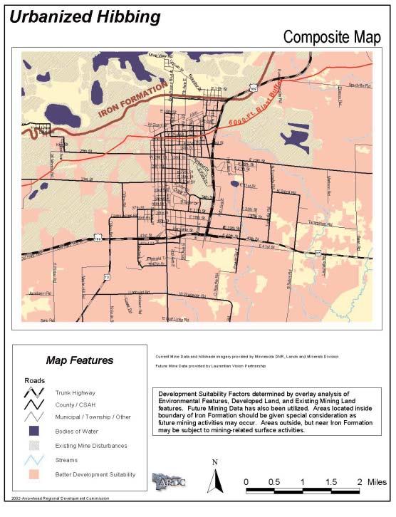
27 Proposed Modification to current land uses Urbanized Hibbing Designate as Open Space Develop into Light Industrial Change to Open Space Agricultural New highway commercial north of Hwy. 169 and east of cemetery Designate lands west of 73 as Open Space, develop community entry Designate as Highway Commercial Change to Residential (both areas) Potential recreational corridor Designate as Open Space Change to Suburban Residential Incorporate any changes with Highway 37 master plan Change to Residential (both areas) Commercial Services Highway Commercial Industrial Natural / Open Space Park and Recreation Residential 1-4 Residential Multiple Residential Multiple Residential Suburban Residential Rural Residential / Agricultural
28
29 Recommendations Commercial-Industrial Areas Develop a common zoning code with the City of Chisholm and Balkan Township. Review residential zoning to ensure regulatory protection for residential areas from adjacent commercial and industrial uses. Consider changes required to support mixed-use development. Consider any new sign regulations. Support community gateway improvements. Assess land uses in the Highway 169 and Highway 37 corridors to identify, and zone for, potential development of existing vacant lands and reuse upgrades of developed lands. Conduct a corridor study for the Highway 169 and Highway 37 corridors. Pursue development of new commercial/retail and a growth development boundary along Highway 169 western edge. Pursue joint corridor development with Balkan Township and the City of Chisholm for the Highway 169 corridor. 8.29
30 Residential Areas Conduct neighborhood planning processes throughout Hibbing. Complete a through review and update/modification of regulatory tools and evaluate development of new tools to: Preserve identified residential assets in established neighborhoods surrounding the city center, protect architectural and historical integrity of residential and commercial uses. Encourage flexible strategies in urban neighborhoods for infill development and productive use of small lots. ( i.e. examine lot size and set back requirements; consider incentives for purchase as sideyards, community gardens). Protect existing and planned neighborhoods from encroaching/ incompatible uses. Ensure compatibility of future residential development and the city s open space planning. Offer incentives for and/or require inclusion of affordable housing within every new development. 8.30
31 Sensitive Undeveloped Areas The areas to be addressed are; the Highway 37 corridor, any new commercial/retail around Highway 73 and Highway 169, the residential/recreational corridor to Carey Lake Hibbing s Planning Commission should move to create a vision of appropriate development and land preservation and to develop zoning to promote development that conforms to that vision. Continue to explore possible recreational use of abandoned mining lands. General Issues Explore, inventory and assess new areas which may be appropriate for industrial development. Undertake a block by block land use and zoning study, and develop a plan which will guide redevelopment of housing adjacent to downtown. Continue to pursue implementation of the downtown revitalization efforts. Ensure adequate protection for residential areas from near by commercial, institutional and industrial development. 8.31
32 Implementation Hibbing s Planning Commission and x Department will be responsible for implementing the land use recommendations of the Comprehensive Plan. 8.32
33 Revitalization Areas North Hibbing / Brooklyn Additional parkland/trail access. Mitigation/elimination of conflicting uses. Redevelop former Brooklyn Elementary School site. Renovate/redevelop residential neighborhoods. Medical Campus Mesabi Mall - encourage health, medical and speciality clinics to locate here - mixing with the other commercial. Eliminate excessive stop signage on East 37th Street. Kmart and Irongate Mall sites Reuse of empty stores. Encourage adjoining property owner to plot and develop local streets for commercial growth. Work with MNDOT to develop new access on Highway 169 and further south on Highway
34
Planning Districts INTRODUCTION
 INTRODUCTION To facilitate detailed examination of development prospects for all areas of the community, Delano has been divided into 14 planning districts. The location of these planning districts is
Sorted citizen input comments in review of Blount County plans July, August, and September 2007
 Sorted citizen input comments in review of Blount County plans July, August, and September 2007 The following presents sorted citizen input comments from three sessions held in July, August and September
CHAPTER 12 IMPLEMENTATION
 CHAPTER 12 IMPLEMENTATION The 2010 Town of Denton Comprehensive Plan is intended to capture a vision of the future of Denton. As such, it provides a basis for a wide variety of public and private actions
Town of Peru Comprehensive Plan Executive Summary
 Town of Peru Comprehensive Plan Executive Communities that plan grow by choice, not by chance. A plan makes growth thoughtful, understandable, and predictable. A plan shows that a community is managing
SECTION II SECTION II STATEMENT OF GOALS, OBJECTIVES, PRINCIPLES, ASSUMPTIONS, POLICIES AND STANDARDS
 STATEMENT OF GOALS, OBJECTIVES, PRINCIPLES, ASSUMPTIONS, POLICIES AND STANDARDS 1 2 STATEMENT OF GOALS, OBJECTIVES, PRINCIPLES, ASSUMPTIONS, POLICIES AND STANDARDS INTRODUCTION The New Jersey Municipal
Chisholm Community Form
 Chisholm Community Form 1.1 Community Goals 1.3 Information and Assessment 1.5 1.12 Recommendations 1.13 1.22 Implementation 1.23-1.26 1.2 Community Goals Neighborhoods Strengthen the sense of community
Implementation Guide Comprehensive Plan City of Allen
 Implementation Guide 2030 Comprehensive Plan City of Allen DRAFT 2015 Implementation Guide Allen 2030 Comprehensive Plan INTRODUCTION The Comprehensive Plan serves as a guide for the growth and development
Port Lavaca Future Land Use
 Port Lavaca Future Land Use Introduction The City of Port Lavaca is beginning to see sustained growth, after many years of relative stable population. New single family homes, apartments, and businesses
LAND USE ELEMENT. Purpose. General Goals & Policies
 LAND USE ELEMENT Purpose This Land Use Element contains the goals and policies necessary to support the City s responsibility for managing land resources and guiding development through implementing regulations,
COMMUNITY DESIGN. GOAL: Create livable and attractive communities. Intent
 COMMUNITY DESIGN Intent An attractive, well-designed County will attract quality development, instill civic pride, improve the visual character of the community, and create a strong, positive image for
Municipal Plan*Assessment
 Municipal Plan*Assessment This tool was developed to assist in reviewing municipal master plans and in determining if these plans are consistent with smart growth principles, neighboring municipal plans,
implementation10 Village of Greendale Comprehensive Plan: Greendale, Wisconsin. Revisiting a Greenbelt Community
 implementation10 Village of Greendale Comprehensive Plan: 2010 - Village of Greendale Comprehensive Plan: 2010 - Implementation The recommendations of this Plan must be implemented by the Village of Greendale,
CONCLUSION AND IMPLEMENTATION
 Lisbon s Vision CONCLUSION AND IMPLEMENTATION 7 Lisbon residents clearly appreciate the character, amenities, and opportunities that define our community. This Plan of Conservation and Development identifies
City of Royalton Comprehensive Land Use Plan 2005 to Revision February 8, 2011
 City of Royalton Comprehensive Land Use Plan 2005 to 2015 2011 Revision February 8, 2011 PART ONE: INTRODUCTION TO THE COMPREHENSIVE PLAN 1.0 Purpose and Introduction The Comprehensive Land Use Plan provides
CHAPTER 4 FUTURE LAND USE AND URBAN SERVICES DISTRICTS
 CHAPTER 4 FUTURE LAND USE AND URBAN SERVICES DISTRICTS Introduction This chapter discusses how Benzie County should grow and change in the future. A community can grow and change in many different ways.
The transportation system in a community is an
 7 TRANSPORTATION The transportation system in a community is an important factor contributing to the quality of life of the residents. Without a sound transportation system to bring both goods and patrons
2018 Northampton Township Comprehensive Plan
 2018 BUCKS COUNTY, PENNSYLVANIA What is a? A comprehensive plan is a municipality s main policy document that details the collective vision for the future, the historic, environmental, and cultural facilities
The following rules shall be used to determine the precise location of any zone boundary shown on the Official Zoning Map of Auburn:
 ARTICLE III. ESTABLISHMENT OF ZONING DISTRICTS Section 300. Establishment of Zoning Districts. The City of Auburn, Alabama is hereby divided into zoning districts of such number and character as are necessary
Comprehensive Plan. Faribault, Minnesota. Hoisington Koegler Group Inc. Claybaugh Preservation Architecture Inc. Howard R. Green Company Bonz/REA
 Comprehensive Plan Faribault, Minnesota Adopted by the Faribault City Council July 8, 2003 prepared for: prepared by: Hoisington Koegler Group Inc. Claybaugh Preservation Architecture Inc. Howard R. Green
SECTION E. Realizing the Plan
 SECTION E Realizing the Plan 60 DESIGN REGINA - OFFICIAL COMMUNITY PLAN SECTION E Realizing the Plan Design Regina has been an ambitious plan-making exercise, with a high level of community, stakeholder,
IMPLEMENTING SOMERSET COUNTY S INVESTMENT FRAMEWORK
 IMPLEMENTING SOMERSET COUNTY S INVESTMENT FRAMEWORK SMART CONSERVATION THROUGH SMART GROWTH NJ LAND CONSERVATION RALLY March 22, 2014 Laurette Kratina, PP, AICP, Supervising Planner Somerset County Planning
RECREATION AND OPEN SPACE ELEMENT GOALS, OBJECTIVES, AND POLICIES
 RECREATION AND OPEN SPACE ELEMENT GOALS, OBJECTIVES, AND POLICIES Goal 7 To provide park facilities, recreation programs, and open space resources that are safe, adequate, and accessible to all City residents,
Improve Neighborhood Design and Reduce Non Point Source Water Pollution
 HOW TO Planning Guide Improve Neighborhood Design and Reduce Non Point Source Water Pollution This document was funded by a grant from the New Hampshire Coastal Program with funding from the National Oceanic
CHAPTER 1. Ms. Guajardo s Class - Central Elementary CH 1 1
 INTRODUCTION CHAPTER 1 Ms. Guajardo s Class - Central Elementary CH 1 1 1.1 SETTING South Centre City is a linear corridor south of Downtown Escondido paralleling Centre City Parkway and South Escondido
ARTICLE 6: Special and Planned Development Districts
 ARTICLE 6: Special and Planned Development Districts 6-10 Traditional Neighborhood Development (TND) District 6-10.10 Purpose and Intent The Traditional Neighborhood Development (TND) District provides
3 TOWN OF WHITCHURCH-STOUFFVILLE OFFICIAL PLAN AMENDMENT NOS. 116 & 117
 3 TOWN OF WHITCHURCH-STOUFFVILLE OFFICIAL PLAN AMENDMENT NOS. 116 & 117 The Planning and Economic Development Committee recommends the adoption of the recommendations contained in the following report,
CHAPTER 2 GOALS, OBJECTIVES AND POLICIES
 CHAPTER 2 GOALS, OBJECTIVES AND POLICIES The goals, objectives and policies of this Comprehensive Plan Update serve as guidelines for directing future growth, revitalization, development, adaptive reuse
FUTURE LAND USE PLAN 7
 FUTURE LAND USE PLAN 7 The recommendations of each of the preceding chapters can be combined to present an overall Future Land Use Plan for Wilton. The Future Land Use Plan, presented on the following
WATERFORD Plan of Preservation, Conservation and Development Supplement Part 1 - Policy Element
 WATERFORD 2012 Plan of Preservation, Conservation and Development 2015 Supplement Part 1 - Policy Element Effective June 11, 2015 2015 Plan Update GOAL To respond to the evolving land use needs and continually
OFFICIAL CONTROLS IMPLEMENTATION LEGAL REQUIREMENTS
 IMPLEMENTATION The objective of the Implementation component of the Comprehensive Plan is to identify the changes that need to be made to the official controls in order to be consistent with the Comprehensive
CITY OF PUYALLUP. Background. Development Services
 CITY OF PUYALLUP Development Services 333 South Meridian Puyallup WA 98371 To: City Council From: Katie Baker, AICP, Planning Division Re: South Hill Neighborhood Plan Adoption Date: (Meeting date: February
Major Subdivision Sketch Plan Checklist
 This checklist provides specific requirements that are apart of the Sketch process. The entire process is described by the Huntersville Subdivision Review Process which details all the submittal and resubmittal
General Location Annex, Rezone & Preliminary Plat Lansdowne Addition, Unit Three
 NEWFOUNDLAND I-5 Agricultural District Subject Site SUNDANCE ANDERSON Single Family Residential CHRISTY PUD Agricultural District Highway Business General Location Annex, Rezone & Preliminary Plat Lansdowne
DISCUSSION TOPIC: ST JOHNS RIVER & ITS TRIBUTARIES (BPII) 2030 COMPREHENSIVE PLAN POLICES AND REGULATORY FRAMEWORK
 2030 COMPREHENSIVE PLAN POLICES AND REGULATORY FRAMEWORK") DISCUSSION TOPIC: ST JOHNS RIVER & ITS TRIBUTARIES (BPII) 2030 COMPREHENSIVE PLAN POLICES AND REGULATORY FRAMEWORK St. John s River & Its Tributaries Issue Summary: The St. Johns River is an important
DISCUSSION TOPIC: ST JOHNS RIVER & ITS TRIBUTARIES (BPII) 2030 COMPREHENSIVE PLAN POLICES AND REGULATORY FRAMEWORK St. John s River & Its Tributaries Issue Summary: The St. Johns River is an important
E. RURAL COMMERCIAL/INDUSTRIAL PARK MODEL
 E. RURAL COMMERCIAL/INDUSTRIAL PARK MODEL 1. PURPOSE The purpose of the Rural Commerce/Industrial Park Model is to provide parameters within which a grouping of business buildings with parking, loading
Official Plan Review
 Official Plan Review Summary Report - The Built Environment August 2014 Part 1: Introduction Planning for a healthy, prosperous and sustainable community is an important goal for our municipality. From
Bourne Downtown Site Planning
 Prepared for: The Town of Bourne, MA In Cooperation with: Bourne Financial Development Corporation Prepared by:, Inc. June 24, 2009 Table of Contents Introduction and Summary... 1 Site Existing Conditions...
Chapter 6: Community Character
 Chapter 6: Community Character The term "community character" covers a broad spectrum of concerns. First and foremost, community character is a visual concept. In Long Grove, however, community character
CHARLES PUTMAN CHARLES PUTMAN AND ASSOCIATES, INC
 MEMORANDUM CHARLES PUTMAN & ASSOCIATES, INC. LAND DEVELOPMENT CONSULTANTS PLANNING ZONING PERMITTING 4722 NW Boca Raton Boulevard, Suite C-106 Boca Raton, Florida 33431 Phone: 561/994-6411 FAX: 561/994-0447
Planning & Zoning Commission Staff Report
 Planning & Zoning Commission Staff Report Meeting Date: May 26, 2015 Drafted by: Katherine Harrison-Rogers CASE # Z2886 PROJECT NAME: APPLICANT/ REPRESENTATIVE: Shawna Runyan PROPERTY OWNER: 1840 (previously
TRANSPORTATION AND LAND USE
 CHAPTER 10 TRANSPORTATION AND LAND USE Transportation and land use are intimately linked. The expansion of a highway typically spurs housing, employment growth and land development in the communities that
CHAPTER 7: VISION AND ACTION STATEMENTS. Noble 2025 Vision Statement
 CHAPTER 7: VISION AND ACTION STATEMENTS This chapter presents the vision, policy and action statements that transform the comprehensive planning study, an analysis of Noble s past, future trends and community
SECTION UNIFIED DEVELOPMENT ORDINANCE SECTION Part 1 Ordinance. ARTICLE 1 Zoning Districts
 SECTION 1-100 UNIFIED DEVELOPMENT ORDINANCE SECTION 1-300 Part 1 Ordinance SECTION 1-100. Introduction. ARTICLE 1 Zoning Districts Crystal Lake strives to maintain a balance of various land uses for a
Chapter 3. Community Vision and Goals
 Chapter 3. Community Vision and Goals 3.1 Public Involvement Charlevoix s master plan was prepared in a way that maximized public participation. Dating back to 2004, the Planning Commission and staff held
TREASURE COAST REGIONAL PLANNING COUNCIL M E M O R A N D U M. To: Council Members AGENDA ITEM 5H
 TREASURE COAST REGIONAL PLANNING COUNCIL M E M O R A N D U M To: Council Members AGENDA ITEM 5H From: Date: Subject: Staff October 17, 2008 Council Meeting Local Government Comprehensive Plan Review Draft
TEMPLE MEDICAL & EDUCATION DISTRICT
 City of Temple, Texas TEMPLE MEDICAL & EDUCATION DISTRICT 1 Description. The City of Temple joined in partnership with key public and private entities to jointly promote education and medical activities
2040 LUP is a part of the Comprehensive Plan and carries the same legal authority. Economic Challenges
 1.1. Guiding Anchorage s Growth Where will new residents settle over the next two decades? Where will people work, shop, and play? Will there be enough room to grow? How will Anchorage look? Will growth
Municipal Comprehensive and Open Space Plans
 Appendix 13-A Local Historic Policy Municipal Comprehensive and Open Space Plans Oxford Regional Comprehensive Plan (1969) The Oxford Regional Comprehensive Plan serves as the Comprehensive Plan for Oxford
3 Vision and Goals. Vision and Goals. Blueprint for Bloomsburg. Vision. Town of Bloomsburg Comprehensive Plan,
 Vision and Goals 3 Vision and Goals Citizens of the Town of Bloomsburg clearly value their natural and cultural heritage, the walkable, mixed use pattern of downtown, the access to education, and the community
Riparian Buffer on the Bushkill Creek. Policies
 Riparian Buffer on the Bushkill Creek Riparian buffers provide numerous benefits to landowners and the community by protecting groundwater recharge areas, providing flood control, providing stormwater
NEIGHBORHOOD DESIGN ELEMENT
 NEIGHBORHOOD DESIGN ELEMENT INTRODUCTION The following recommendations constitute an urban design oriented "neighborhood analysis" of Plantation. It is an optional Comprehensive Plan Element. The five
Guiding Principles, Objectives, Strategies and Policies
 Guiding Principles, Objectives, Strategies and Policies Section 1 Introduction These Guiding Principles were adopted as part of the 1999 Athens-Clarke County Comprehensive Plan and are carried over, in
Chapter 13: Implementation Plan
 Implementation A. Introduction The Implementation Plan, in table form on the following pages, provides a summary of all the Action Items recommended in Chapters 2 through 12. The table also indicates which
Westport Master Plan. Town of Westport. Master Plan Master Plan Update Committee. Westport, Massachusetts
 Town of Westport Master Plan 2004 Master Plan Update Committee Westport, Massachusetts Open Space and Recreation 5-1 Table of Contents Table of Contents... i List of Tables... ix List of Figures... ix
The Five Components of the McLoughlin Area Plan
 The Five Components of the McLoughlin Area Plan This documents contains the complete language of the five components of the McLoughlin Area Plan: The Vision Statement The Values The Guiding Principles
Warren County/Bowling Green Focus 2030 Comprehensive Plan VOLUME 1 INDEX
 Appendix 5: Index VOLUME 1 INDEX A Aesthetics ES-6, FLU-15, FLU-17, FLU-24, NCR-7 Agricultural Base FLU-18, FLU-20 Agricultural Centers, Rural FLU-11 Agricultural District NCR-17-NCR-18 Agricultural Economy
PSRC REVIEW REPORT & CERTIFICATION RECOMMENDATION
 PSRC REVIEW REPORT & CERTIFICATION RECOMMENDATION KITSAP COUNTY COUNTYWIDE PLANNING POLICIES July 2, 2012 BACKGROUND A major emphasis of the Washington State Growth Management Act (GMA) is the need to
CHAPTER 2: PLANNING PRINCIPLES
 CHAPTER 2: PLANNING PRINCIPLES 2 Comprehensive Principles The following overarching Principles provide the basis for the goals and policies included in the Mendocino County General Plan. These Principles
A. WHAT IS A GENERAL PLAN?
 I. Introduction A. WHAT IS A GENERAL PLAN? A general plan is the planning guideline for the future of a city. It contains goals and policies which regulate urban development, the protection of the natural
Rural Land Use Designations Kittitas County December 6, 2007 Draft
 KITTITAS COUNTY COMMUNITY DEVELOPMENT SERVICES 411 N. Ruby St., Suite 2, Ellensburg, WA 98926 CDS@CO.KITTITAS.WA.US Office (509) 962-7506 Fax (509) 962-7682 Rural Land Use Designations Kittitas County
Iron Range. Central Iron Range Initiative Concept Plan
 Central Iron Range Initiative Concept Plan Iron Range Acknowledgements This plan was produced by: The citizens of the Central Iron Range who shaped this agenda for the region s future by participating
Status Report: MD 355 Project
 Status Report: MD 355 Project OCTOBER 2006 M-NCPPC MONTGOMERY COUNTY PLANNING DEPARTMENT Summary of Community Comments, and break to the Results of the MD 355 Participation Session Brookside Gardens -
Best Practices Appendix: Waterfront Communities
 Redevelopment Ready Communities Best Practices Appendix: Waterfront Communities revised September 2014 Waterfront RRC defined The purpose of these additional criteria is to provide waterfront communities
This page has been intentionally left blank.
 This page has been intentionally left blank. Chapter 3 3-2 3. Employment 3.A Niagara Economic Gateway 3.A.1 General The Niagara Economic Gateway comprises: a) The Gateway Economic Zone which includes all
Gloucester County s Comprehensive Plan. The Community Connection
 Gloucester County s Comprehensive Plan The Community Connection Current Comp Plan Adopted in 1991 with a 20 year planning horizon Updated in 1995 with Part V- Implementation Recommendations and Appendix
EXISTING COMPREHENSIVE PLAN
 EXISTING COMPREHENSIVE PLAN Town Center Land Use Element: V. LAND USE POLICIES Town Center Mercer Island's business district vision as described in "Your Mercer Island Citizen-Designed Downtown" was an
City of Heath. Town Center Concept
 In the give-and-take of getting projects designed, financed, and approved, the famous refrain from the film Field of Dreams is heard often: if you build it, they will come. From the perspective of the
EXHIBIT A. Tax Increment Reinvestment Zone No. 1 (Town Center) First Amended Project Plan 1
 First Amended Project Plan 1") EXHIBIT A Tax Increment Reinvestment Zone No. 1 (Town Center) First Amended Project Plan 1 1 As amended by Resolution No. 2008-02-001(TR1R) of the Tax Increment Reinvestment Zone No.1, and approved to
EXHIBIT A Tax Increment Reinvestment Zone No. 1 (Town Center) First Amended Project Plan 1 1 As amended by Resolution No. 2008-02-001(TR1R) of the Tax Increment Reinvestment Zone No.1, and approved to
Town of Cobourg Heritage Master Plan. Statutory Public Meeting
 Town of Cobourg Heritage Master Plan Statutory Public Meeting April 25 th 2016 Presentation Overview 1. Introduction 2. Project background and schedule overview 3. Review of strategic direction content
Hockessin Community Redevelopment Plan
 Hockessin Community Redevelopment Plan 3.1 Introduction The Community Redevelopment Plan for the Village of Hockessin is the result of the people s vision for a distinct village center that serves as the
4 Sustainability and Growth Management
 4 Sustainability and Growth Management Introduction Traditionally, has assumed growth and development with limited consideration for the long-term negative social, environmental or economic impacts on
STORMWATER GREEN INFRASTRUCTURE AND PLANNING/ZONING BOARDS
 STORMWATER GREEN INFRASTRUCTURE AND PLANNING/ZONING BOARDS Source: Center for Watershed Protection, 2007 Southern Tier Central Regional Planning & Development Board Chemung County Stormwater Team OUTLINE
Applicant Name Phone / Fax / Address City State Zip Code . Property Owner Phone / Fax / Address City State Zip Code
 Master Development Plan Application Community Development Department City of Redmond 411 SW 9 th Street Redmond, Oregon 97756 541-923-7721 541-548-0706 FAX Master Development Plan Fee $38,862.52 File Number
This chapter describes the purpose of the Plan, introduces how the Plan is organized and provides contextual background for the Plan.
 Chapter 1: INTRODUCTION Purpose of a Comprehensive Plan The 2040 Comprehensive Plan establishes Medina s vision as a community and sets goals and objectives which guide future decisions and policies. The
The Floyds Fork Area Study A Framework for Growth
 The Floyds Fork Area Study A Framework for Growth 2 21 st Century Parks Master Plan: The Fork 3 Neighborhood Development Area Policy Recommendations 1. Create incentives to promote infill of existing development
Source: Albemarle County Community Development 2010
 Source: Albemarle County Community Development 2010 GROWTH MANAGEMENT GOAL: Albemarle County s Development Areas will be attractive, vibrant areas for residents and businesses, supported by services, facilities,
Laberge Group. Town of Coeymans. Draft Comprehensive Plan. Overview of Planning Process
 Draft : Presentation of Goals & Strategies Laberge Group Benjamin H. Syden, A.I.C.P., E.D.P Director in Charge Nicole Allen, A.I.C.P. Senior Planner Anjali Malhotra Planner Presentation Outline Introductions
CITY OF COLWICH COMPREHENSIVE PLAN LAND USE LAND USE 1
 LAND USE LAND USE 1 WHAT YOU WILL FIND IN THIS CHAPTER: Discussion of today s conditions and tomorrow s projections Discussion of challenges and opportunities Discussion of the environmental quality goals,
Asbury Chapel Subdivision Sketch Plan
 Asbury Chapel Subdivision Sketch Plan PART 1: PROJECT SUMMARY Applicant: NVR Inc. Project Size: +/- 76.13 acres Parcel Numbers: 02101112,02116101,02116112, 02116113 Current Zoning: Transitional Residential
THE GARDEN CITY PLAN. City of St. Catharines Official Plan. City of St. Catharines
 THE GARDEN CITY PLAN City of St. Catharines Official Plan City of St. Catharines August 2010 APPROVAL INFORMATION This Official Plan of the City of St. Catharines Planning Area, known as the Garden City
Section 9 NEIGHBORHOOD DESIGN
 Section 9 NEIGHBORHOOD DESIGN City of Lancaster Comprehensive Plan D u n k i n, S e f k o & A s s o c i a t e s, I n c. NEIGHBORHOOD DESIGN INTRODUCTION There are many ways in which a neighborhood can
Chapter 2: Vision, Goals and Strategies
 Chapter 2: Vision, Goals and Lake Elmo Today & Tomorrow Comprehensive Plan 2040 2 VISION, GOALS & STRATEGIES - DRAFT 4-6-2018 INTRODUCTION Comprehensive Plan Purpose Perhapse the most important objective
8implementation. strategies
 PROGRAM STRATEGIES 8implementation strategies T he implementation actions of this chapter are designed to support and carry out the land use, economic development, transportation, urban design, and program
Plan Overview. Manhattan Area 2035 Reflections and Progress. Chapter 1: Introduction. Background
 Plan Overview The Manhattan Urban Area Comprehensive Plan (the Comprehensive Plan) is a joint planning initiative of the City of Manhattan, Pottawatomie County, and Riley County. The 2014 Comprehensive
Chapter 1 Vision Statement & Goals
 Chapter 1 Section 1.1 Section 1.2 Section 1.3 Section 1.4 Section 1.5 Introduction Vision Statement Visioning Exercise Prioritization of Land Use Issues Goals of the Comprehensive Plan CHAPTER 1 SECTION
Beatties Ford Road & Mt. Holly-Huntersville Road Small Area Plan
 Beatties Ford Road & Mt. Holly-Huntersville Road Small Area Plan Town of Huntersville October 2005 Town of Huntersville Planning Department 101 Huntersville Concord Road Post Office Box 664 Huntersville,
Chapter 10 IMPLEMENTATION RECOMMENDATIONS
 Chapter 10 IMPLEMENTATION RECOMMENDATIONS The recommended land use plan presented in the previous chapter provides a design for the attainment of the urban and rural development and open space preservation
4-Town Comprehensive Plan DRAFT 7/30/07
 4-Town Comprehensive Plan DRAFT 7/30/07 Acknowledgements ning Committee Town of Harrisburg Norman Roof Randy Nicol Town of Martinsburg Terry Thisse Paul Kelly Town of Montague Jan Bagdanowicz Wendy Perry
LU Encourage schools, institutions, and other community facilities that serve rural residents to locate in neighboring cities and towns.
 Application No. 891627: Comprehensive Plan Text Amendment - Rural School Policies - Amend policies consistent with State Legislation allowing schools in the rural area and extension of sewer service to
CHAPTER 3 VISION, GOALS, & PLANNING PRINCIPLES. City of Greensburg Comprehensive Plan. Introduction. Vision Statement. Growth Management Goals.
 CHAPTER 3 VISION, GOALS, & PLANNING PRINCIPLES Introduction The Greensburg Comprehensive Plan is intended as a working community document. A combination of long and short-term goals, this document is intended
VILLAGE OF CLEMMONS PLANNING BOARD DRAFT STAFF REPORT
 VILLAGE OF CLEMMONS PLANNING BOARD DRAFT STAFF REPORT PETITION INFORMATION Docket # C-226 Staff Megan Ledbetter Petitioner(s) JBJH Properties, LLC Owner(s) JBJH Properties, LLC Subject Property 5892-49-1766
A Growing Community Rural Settlement Areas
 Town of Huntsville Official Plan Review - POLICY BACKGROUND PAPER A Growing Community Rural Settlement Areas BACKGROUND: In addition to the fully municipally-serviced Urban Settlement Area and the Hidden
TREASURE COAST REGIONAL PLANNING COUNCIL M E M O R A N D U M. To: Council Members AGENDA ITEM 5I
 TREASURE COAST REGIONAL PLANNING COUNCIL M E M O R A N D U M To: Council Members AGENDA ITEM 5I From: Date: Subject: Staff December 12, 2008 Council Meeting Local Government Comprehensive Plan Review Town
THE 355/270 CORRIDOR:
 THE 355/270 CORRIDOR: Strategic Ideas for Sustaining a Livable Work Place Project Summary ACCESS LIFE DESIGN HEALTH WORK Montgomery County Planning Department The Maryland-National Capital Park and Planning
ESTABLISH AN EFFICIENT TOWN CENTER
 ESTABLISH AN EFFICIENT TOWN CENTER 4 Overview Lisbon residents are proud of the history of Newent and at the same time recognize its current importance as a centralized location for a variety of municipal
Status Update (2006 vs. Now) Citizen s Advisory Committee February Plan for Prosperity
 Citizen s Advisory Committee February Plan for Prosperity") Status Update (2006 vs. Now) Citizen s Advisory Committee February 2018 Plan for Prosperity 2000 2017 2000 2017 Gardnerville Population 6,000 5,760 5746 5,500 5,000 5,067 5,550 5,165 5,394 5,412 5,250
Status Update (2006 vs. Now) Citizen s Advisory Committee February 2018 Plan for Prosperity 2000 2017 2000 2017 Gardnerville Population 6,000 5,760 5746 5,500 5,000 5,067 5,550 5,165 5,394 5,412 5,250
DRAFT MAP AMENDMENT FLU 04-4
 DRAFT MAP AMENDMENT FLU 04-4 SW 24 TH AVENUE ROADWAY CORRIDOR The University of Florida participates with the Metropolitan Transportation Planning Organization (MTPO) in its responsibilities for the continuing,
3.5 Historic Old Town Character Area
 3.5 Historic Old Town Character Area Downtown Suwanee is characterized by two areas: Historic Old Town and Town Center. Due to their proximity and similar purposes, the two areas can function together
How To Get the Development You Planned
 How To Planning Series Prepared by Strafford Regional Planning Commission. Funded by the NH Office of State Planning How To Get the Development You Planned The purpose of the master plan is... to guide
3. VISION AND GOALS. Vision Statement. Goals, Objectives and Policies
 Vision Statement Queen Creek s interconnected network of parks, trails, open spaces and recreation opportunities provide safe and diverse activities and programs that sustain its unique, small town, equestrian