Calderdale the Next Chapter
|
|
|
- Damian Nelson
- 5 years ago
- Views:
Transcription

1 Calderdale the Next Chapter Investing in transport, public spaces and businesses Our vision is all about creating a place where people want to live, visit, study and work. A place where businesses want to locate,a place that attracts investment and interest from a whole range of sectors. We re building on our heritage, our fine architecture, our vibrant business sector and our strong communities. To achieve this we re delivering these projects: West Yorkshire-plus Transport Fund A629 Salterhebble to Shaw Hill A629 Calder and Hebble Junction A629 Halifax Town Centre A629 Huddersfield to Halifax A629 Ainley Top to Huddersfield (Kirklees Led) A629 Corridor Improvement Scheme A58 Corridor Improvement Scheme Halifax Rail Gateway Elland Rail Station A641 Bradford to Huddersfield 150m annual economic benefit Creating 2,000 job opportunities Halifax Town Centre Delivery Plan Leisure Centre Borough Market Northgate House Adding 2.4bn per year to the economy by the mid-2030s West Yorkshire-plus o match similar material Transport Fund The West Yorkshire-plus Transport Fund has been created to increase housing, employment and economic good growth across the West Yorkshire region and York. This programme will create an even better place to live, work, study and visit through transport improvements across all modes. Congestion Bus infastructure Journey times Pedestrian / cycle accessibility Improve air Calderdale Council

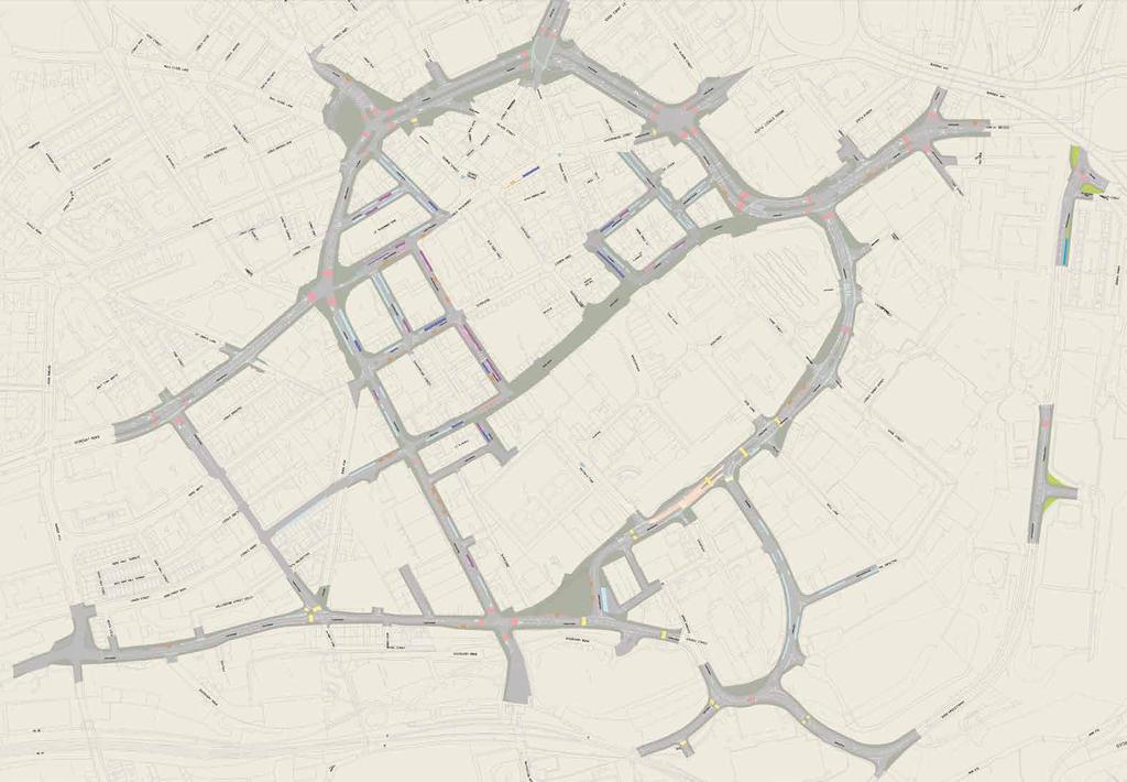
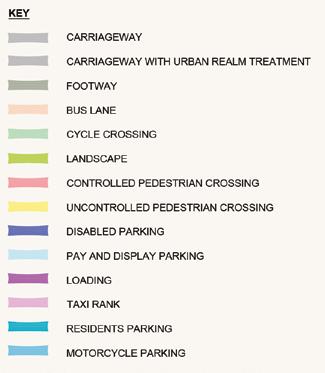
2 town centre project overview The A629 Halifax Town Centre project will provide improved accessibility to the town for all residents and visitors. It will achieve a greater sense of place and deliver regeneration and assit our growth aspirations. The project will also deliver modern multi-modal transport infrastructure enhancements across the town centre. Project highlights: Bus-rail interchange opportunities created Improvements to bus station and infrastructure Removal of subways Remodelling of Bull Green junction Creation of a Bus Box to improve bus accessibility Pedestrianisation of Market Street Enhance the urban realm at Commercial Street (frontage of Victoria Theatre) Creation of Piece Gardens Improved pedestrian and cycling facilities throughout town and at all junctions Creation of modified eastern route to allow through traffic to avoid town centre core Improved Western route to reduce congestion, journey times and improve pedestrian facilities Investment benefits: Improved journey times for through traffic, especially at peak times Safer journeys for vulnerable road users and motor vehicles Increased pedestrian and cycling activity More vibrant local economy More attractive town centre Urban regeneration through investment Business growth through increased footfall and trade
3
4 Shaping our plans We ve held an extensive engagement programme with key stakeholders and with residents of Calderdale. We gained some really useful feedback, particularly at our public exhibition in July Based on feedback and suggestions we ve improved our plans: Working with Historic England we have designed Hughes Square to reflect the history of the area and a cultural compass to enable better way finding of the historic assets in town You said The buses need to come closer to the market We need to be able to turn right out of George Street We did We diverted the bus route onto King Edward Street Traffic signals at the George Street / Cow Green junction will allow a right turn We want stronger pedestrian links between the town centre and Park Ward Traffic signals introduced at Bull Green with improved pedestrian crossing facilities Crossing facilities at Prescott Street are poor The re-designed junction has much better facilities for pedestrians Let s have less street clutter The bollards on Crown Street and Southgate don t work We need access south from Commercial Street The newly pedestrianised Market Street will have much less clutter These will be replaced as part of the project One lane of traffic can leave Commercial Street, travelling south, at the Wards End junction Enforce the bus gate on Commercial Street and Market Street We don t feel safe in subways We need to be able to turn right into Rawson Street when travelling north on Fountain Street The proposed rail interchange on the Eureka! car park significantly increases the journey times for buses Market Street will be pedestrianised and Commercial Street will have Automatic Number Plate Recognition enforcement The subways at Cow Green / Pellon Lane will be removed and replaced with pedestrian crossings Changed traffic flow and introduced a right turn into Powell Street A bus-rail interchange will be located between the town centre and the railway station


5 Cycling Our Cycling Strategy sets out to make Calderdale a nationally recognised centre of cycling excellence where residents, tourists and visitors of all ages and abilities can cycle. A key objective of this project is to maximise access for cyclists within Halifax Town Centre in order to positively promote cycling as a mode of transport. We have carefully designed the urban realm to clearly define cycling areas. We will use street furniture lines to encourage cycling away from buildings lines and shop fronts. As part of the urban design, we will also include subtle cycle symbols throughout key areas to communicate the likely presence of cyclists to pedestrians and other road users and to aid route finding for cyclists. Key areas: Northgate Corn Market (Southgate) Russell Street Market Street active calderdale

6 Buses To maximise public transport access to the town centre and keep walking distances short, particularly for elderly people and those with mobility impairments, we re improving the bus routes. The improvements will provide greater operational flexibility for bus operators and will be convenient for bus users. Bus operators will be following the route of the new bus box around town. The route is: Commercial Street King Edward Street Southgate Wards End Horton Street Church Street Square Road Winding Road Northgate Broad Street Water House Street back onto Commercial Street. Details: A Close the existing western vehicle entrance / exits into Halifax bus station and reinstate the existing emergency access into the bus station from Winding Road. B Create a new double bus stop on Winding Road, near the bus station. A B C D E Consolidate Bus Stop 20 and 21 at the southern end of Commercial Street, which will become a double-bay bus stop. Create a taxi rank provision at the southern end of Commercial Street to serve trip attractors (night time economy) at this end of town. On Commercial Street, create a new bus stop adjacent to Cheapside. H E F Create a new eastbound / anticlockwise bus stop on Horton Street between Wards End and Commercial Street. G H Create a bus stop / setting down provision on Albion Street, which will be restricted to the use of the Access Bus. The existing bus stops and access on George Street (off Water House Street) will be retained as part of the project, since this serves as a mini bus hub for the west of the town centre. D C G


7 northern Gateway We re improving connectivity of the town centre, in particular to the north of the town, including Dean Clough Mills, Northbridge Leisure Centre and the Broad Street Plaza. The northern route will include: Improved urban realm at Northgate Improved pedestrian and cycle infrastructure on Northgate and Northbridge Improved non-motorised user crossing facilities at all junctions Improved co-ordination of junctions, reducing congestion with fewer idling vehicles queuing past the Town Hall Market Street The plan for Market Street is to better integrate this area into the wider shopping / cafe offer within Halifax and help to secure their future viability and long term survival as a key part of Halifax s commercial centre. Market Street improvements will include: Creation of a completely pedestrianised town centre core Removal of dominant traffic near the Borough Markets, particularly buses Significant improvement for vulnerable road users Resurfacing with high quality materials that complement the Borough Market Reduction in the visual traffic intrusion and visual clutter of parking and loading vehicles on Market Street Key areas: Northbridge Broad Street Cross Hills

8 Southern and Western GatewayS The improvements to the south and west of town, aim to create attractive public spaces and to encourage both the day and night time economy of this area of Halifax. To achieve this, we will remove the roundabout at Bull Green and create a new public square. Work in this area will include: Bus services will turn left and right out of George Street onto Cow Green after the Bull Green junction modification Fountain Street and Wards End will be linked to create a south western Gateway into the town Pedestrian super-crossing introduced to boost connectivity The Bull Green junction will be modified to allow for southbound only movements from Commercial Street onto Skircoat Road, but no right or left turns Movements will be restricted from the other links onto the junction, such as no right-turns from Skircoat Road onto Wards End Benefits Increased safety for night time economy Creation of public realm at Bull Green Create a public space at the junction A gateway to the south and the west of the town centre Improved co-ordination of junctions, reducing congestion with fewer idling vehicles queuing past the Theatre Place making opportunity to encourage daytime and night time economies Enhanced streetscape including carriageway narrowing outside the Theatre Reduced visual traffic intrusion and visual clutter of parking, loading vehicles and traffic signs outside the buildings will improve the aesthetic quality of their setting and heighten their landmark status The proposed landscaping will provide an attractive streetscape outside the buildings and thereby encourage their use for leisure / cultural activities and there is scope for outdoor seating outside the Victoria Theatre Key areas: Bull Green Commercial Street Cow Green George Street

9 Bull Green

10 Eastern gateway We re introducing a new public square, Piece Gardens. Piece Gardens will be created outside of the Square Chapel, which will require closure of the Square Road Link and realigning Church Street. A new bus hub will be created on Church Street and Alfred Street East to facilitate a bus and rail interchange. The public square will provide enhanced pedestrian and cycle access from the Rail Station to Halifax Town Centre. We will modify the Horton Street / Church Street junction to improve its operational efficiency. Pedestrian access will be improved through the creation of both super crossings and uncontrolled crossings. We will be widening the bridge over the Hebble Brook at Bank Bottom and constructing a new retaining wall to enable improvements to the road alignment at the junction with Charlestown Road. This will improve the easter corridor route, making it an alternative route for all traffic. Key areas: Church Street Bank Bottom Berry Lane Charlestown Road

11 Piece Gardens

12 Piece Gardens - mood board Paving Predominant use of Scoutmoor yorkstone paving to integrate with the wider public realm. Beckett Street Signage Incorporating cast or inset metal signage into large pieces of natural stone. Cultural Compass Creation of a plinth for the Cultural Compass providing way finding for the three principal pedestrian routes. Rain Garden Rain garden planting to attenuate storm water, provide all year round visual amenity and improve biodiversity. Tree Planting Tree planting to the rain gardens to provide additional definition to the space. Informal Bus Stop Seating Including informal bus waiting, providing views of the rain gardens.


13 Piece Gardens 2017 was a big year for Halifax Town Centre. Major changes: Piece Hall Square Chapel New Library and Central Archive This visually striking group of key historic buildings in the town centre, surrounded by other historic buildings, contribute to their setting and the character and appearance of the Halifax Conservation area. The improvements to public realm will solidify the landmark status of the Square Chapel, Steeple, Library and Piece Hall to present a finished product in the restoration of these buildings leading to increased footfall and the continued vitality of this part of the town.

14 Piece Gardens and rail station Hughes Square Key Scoutmoor Yorkshire Paving Soutmoor Linear Yorkshire Paving Scoutmoor Yorkshire Setts Amenity Grass Raingarden Planting Retaining Seating Wall 1m Wide Seating Wall Granite Banding Informal Bus Stop Seating Cultural Compass Clipped Ornamental Hedge Etched Paving Silver Grey Granite Steps Bus Shelter Specimen Trees

15 Rail Station


16 Rail Station Halifax Station is a key gateway not only for Calderdale but for North England. It is an entry point into our thriving town adjacent to major employers, our national children s museum and heritage destinations including the iconic Piece Hall. This project, which is part-funded by the West Yorkshire-plus Transport Fund, proposes transformational change to Halifax Rail Station. A regionally recognised, landmark station with world class facilities that serves as an instantly recognisable hub and gateway to Halifax Town Centre; combining rich heritage assets with unique design that responds to the area s distinctiveness, revitalising the relationship between the station, the town and its ambitious renewal to create vibrancy and confidence that define Halifax as it embraces its future. Major changes: A new station building A passenger circulation area within the main station building, which addresses all directions of approach Re-opened platform brought back into use A new vehicular interchange / car park Pedestrian and cycle access provided from four primary directions Re-establishment of east west permeability to stimulate regeneration Creation of development plots which: o Strengthen urban definition and built form o Provide activity and animation o Provide commercial return from development partnerships


17 Keep up to date Project next steps We re continuing to work out the final details of our plans, and over the coming months we will submit our full business case to the West Yorkshire Combined Authority. Northgate House Indicative timeline Autumn Submit full business case to the West Yorkshire Combined Authority Early Approval of plans and funding granted Spring / Summer Project delivery begins 2022 Project completion Halifax transformed! Leisure Centre Next Chapter Projects As part of our regeneration programme for Halifax Town Centre, we re also delivering major projects to build a new Leisure Centre and to refurbish Northgate House. Get in touch Keep up to date on all of the investment projects that make up Calderdale s Next Chapter at: Get in touch at: Thenextchapter@calderdale.gov.uk
West Blackhall Street Public Realm Public Exhibition
 West Blackhall Street Public Realm Public Exhibition Welcome Introduction Thank you for coming to this public engagement, your input is sought to help to deliver high quality public realm improvements
WEST BLACKHALL STREET PUBLIC REALM + TOWN CENTRE CONNECTIONS Public Exhibition 28 th June 2018
 WEST BLACKHALL STREET PUBLIC REALM + TOWN CENTRE CONNECTIONS Public Exhibition 28 th June 2018 Welcome Introduction Design Your Involvement Thank you for coming Engagement We would like to gather to this
Making the case for Sustainable Transport Project Potential
 Making the case for Sustainable Transport Project Potential The Structural Investment Fund (SIF) Strategy for Greater Lincolnshire identifies the barriers to growth identified by having poor transport
Vision for Irvine: a self-confident town where people aspire to live and work and which they are proud to call home
 Vision for Irvine: a self-confident town where people aspire to live and work and which they are proud to call home Stunning view out to the harbourside Artist s impression of how the Bridgegate area could
HS2 Interchange Station Design
 Working on behalf of HS2 Interchange Station Design October 2018 www.hs2.org.uk 1 Interchange Station, Solihull Introduction In February 2018, HS2 Ltd appointed Arup to take forward the design of Interchange
Rotherhithe Rotherhithe Area Vision Map
 Area Vision Map CWAAP1 Improved pedestrian and cycle links to the wider area Improved link from town centre to River Thames and docks CWAAP2 Brunel Museum NSP79 CWAAP3 Proposed Thames Crossing Station
OPTIONS QUESTIONNAIRE
 OPTIONS QUESTIONNAIRE Mark the Yes column for each statement that you agree with Mark the No column for each statement that you disagree with Please complete all the statements if possible. Please add
PUTTING THE HEART INTO BATTERSEA. A vision
 PUTTING THE HEART INTO BATTERSEA A vision INTRODUCTION This document is a vision for creating a Battersea that its community can be proud of and it is about putting Battersea on the map. It is being proposed
Response to the London Bridge Area Vision and Site Allocations within the New Southwark Plan
 1 Melior Place London SE1 3SZ 020 7407 4701 teamlondonbridge.co.uk info@teamlondonbridge.co.uk 28 April 2017 Response to the London Bridge Area Vision and Site Allocations within the New Southwark Plan
Chapter 9 Route window W18 Slough station. Transport for London
 Chapter 9 Route window W18 Slough station Transport SLOUGH STATION 9 Route window W18 Slough station 9.6 Wexham Road bridge worksite north; and Wexham Road bridge worksite south. Uxbridge Road bridge
0 9 Areas of Change 59
 09 Areas of Change 59 09 Areas of Change This section explores seven areas of change within Solihull Town Centre which provide practical interventions in order to deliver the emerging concepts outlined
Welcome to our exhibition
 Welcome to our exhibition housing development A46 Wildmoor Alcester Road Canal Quarter A422 Town Centre housing development Warwickshire-based IM Properties, one of the UK s largest privately owned property
REPORT BACK BROADSHEET 3 May 2016
 Paddington Place REPORT BACK BROADSHEET May 06 Architects and planners should work with the community first and then thinking about developers profits second. - Quote from participant at Paddington Place
A VISION FOR THE FUTURE
 A VISION FOR THE FUTURE Doncaster Urban Centre Masterplan Foreword CREATING A SUCCESSFUL URBAN CENTRE THE MASTERPLAN Doncaster is an ambitious borough and very few places in the UK come close to us in
heuston gateway: sections heuston gateway: regeneration strategy and development framework plan
 B B1 A B1 B C A heuston gateway: sections B B1 C 117 4.3.3 Zoning The station is the central hub of the area and this function must be preserved and developed. However large areas of the Heuston Station
Colchester Northern Gateway Master Plan Vision Review Draft. July 2016
 Colchester Northern Gateway Master Plan Vision Review Draft July 2016 Contents Introduction 4 Context 8 Purpose of the Report 8 Strategic Position 9 Overview of the Process 11 2012 Master Plan Vision 12
Huddersfield. Urban Design Strategy
 Huddersfield Urban Design Strategy Consultation Draft Summer 2009 Huddersfield Urban Design Framework Page 3 Huddersfield Urban Design Strategy Report by URBED (Urbanism, Environment and Design) For Kirklees
Key Themes and Responses May 2016
 King and Victoria Transit Hub and Waterloo Street Pedestrian Access Key Themes and Responses May 2016 The following summarizes what Regional staff heard about the King Victoria Transit Hub and Waterloo
PUBLIC REALM STUDY AREA
 WELCOME PUBLIC REALM STUDY AREA WHAT IS PUBLIC REALM? Welcome to the Ballina Town Public Realm public consultation event. Mayo Council is in the process of producing a Public Realm Strategy for Ballina
3.3. Urban Structure Defining a New Hierarchy of Routes and Spaces >Images
 Section 3.0 I The Masterplan Framework 18 >Images Examples of high quality routes and spaces 3.3. Urban Structure The success of any masterplan lies in a clear definition of the future urban structure
PLANNING STATEMENT. Market House Market Place Kingston upon Thames KT1 1JS
 PLANNING STATEMENT To support planning and listed building consent applications for change of use from Class A1 shop and Class A3 cafe to Class A3 restaurant at: Market House Market Place Kingston upon
Streets for All East of England
 Streets for All East of England Summary In 2017 Historic England published an updated national edition of Streets for All, a practical guide for anyone involved in planning and implementing highways and
Vision for East Cowes
 Vision for East Cowes A better East Cowes for now and the future The East Cowes Regeneration project is a major regeneration scheme on the Isle of Wight. It will create a vibrant community with a long-term
Market Place Bythell Place Queen Street Park Riverside Park. Public Spaces. Blenheim CBD Streetscape Final Report 36
 37 39 41 43 Market Place Bythell Place Queen Street Park Riverside Park Final Report 36 Market Place Market Place is a key space for Blenheim s street life, it is a meeting place, retail edge and pedestrian
4 Urban Design Issues & Goals
 4 Urban Design Issues & Goals Urban design is a primary consideration for preparing a development strategy for State Highway 1. It is crucial for the future vibrancy and vigour of the Kapiti Coast communities
Eastbourne Borough Council. Summary Proof of Evidence Of Barry John Cansfield BA (Hons), BTP, MRTPI on behalf of PRLP
, BTP, MRTPI on behalf of PRLP") Eastbourne Borough Council (Arndale Centre and surrounding Land at Terminus Road, Sutton Road and Ashford Road) (Compulsory Purchase Order 2015) Section 226 (1)(a) of the Town and Country Planning Act
Eastbourne Borough Council (Arndale Centre and surrounding Land at Terminus Road, Sutton Road and Ashford Road) (Compulsory Purchase Order 2015) Section 226 (1)(a) of the Town and Country Planning Act
ANCHOR TO ANCHOR. Rescale the street to create an iconic boulevard.
 ANCHOR TO ANCHOR Rescale the street to create an iconic boulevard. UR NE ER UV GO NE LA OBJECTIVES 1. Maintain appropriate traffic flow and prioritize commercial curb access 2. Mark gateways at the street
Peckham Peckham Area Vision Map
 Area Vision Map PNAAP13 PNAAP8 Sumner Road Surrey Canal Walk Bird in Bush Park Key: NSP Site Allocations PNAAP Allocations Greenspace Low Line Cycle Network Primary Shopping Areas Square Surrey Canal Walk
16. Peckham Peckham Area Vision
 16. 16.1. Area Vision 16.1.1. is: A lively town centre providing a range of daytime and night time activities on Rye Lane including a Library, a Leisure Centre and many independent retailers which specialise
GREATER CAMBRIDGE CITY DEAL. Urban Design Guidance for Transport Infrastructure Projects
 GREATER CAMBRIDGE CITY DEAL Urban Design Guidance for Transport Infrastructure Projects KEY OBJECTIVES OF CITY DEAL The City Deal aims to help Greater Cambridge maintain and grow its status as a prosperous
Huddersfield Urban Design Framework. 3. Framework
 3. Framework The illustrative plan has been used as the basis for developing an urban design framework and strategy in Part 3 of this report. This is based on a series of regulatory plans that code the
Can town centres retain the social heart of our communities?
 Urban Design Group Solent - June 2013 Can town centres retain the social heart of our communities? Examples of strategic masterplanning and public realm design to re-invent urban centres Peter Frankum
97 Lea Bridge Road, Leyton, E10 7QL London Borough of Waltham Forest December 2015
 97 Lea Bridge Road, Leyton, E10 7QL London Borough of Waltham Forest December 2015 Public Realm and Landscape Proposals LEA BRIDGE ROAD, WALTHAMSTOW Public Realm & Landscape Proposals BDP(90)RPT001 December
Rotherham Interchange
 Rotherham Interchange Opportunity Sites South Yorkshire Passenger Transport Executive (SYPTE) have been successful in securing 12 million funding for the refurbishment of Rotherham Interchange. The bus
Camberwell Camberwell Area Vision Map
 Area Vision Map NSP23 Burgess Park Edmund Street NSP29 NSP30 NSP31 New Road Benhill Road NSP27 NSP33 Green Brunswick Park NSP22 station NSP24 Peckham Road NSP26 St Giles Church Lucas Gardens NSP28 NSP25
Public Consultation. Land at Monks Farm, North Grove. Welcome
 Welcome Welcome to our public exhibition for development on Land at Monks Farm, orth Grove. Gallagher Estates and Gleeson Strategic Land are preparing an outline planning application for new homes, open
Elephant and Castle. Elephant and Castle Area Vision Map. Elephant and Castle. 216 New Southwark Plan Proposed Submission Version NSP42 NSP49 NSP44
 Area Vision Map Lamberth North Station Waterloo Road Southwark Station NSP49 NSP43 Blackfriars Rd St George s Road Borough Road NSP48 Great Suffolk Street NSP42 NSP44 NSP45 Borough Station Newington Gardens
THE CIVIC DISTRICT DEVELOPMENT OPPORTUNITIES
 1 THE CIVIC DISTRICT DEVELOPMENT OPPORTUNITIES The Civic District is the physical and emotional heart of the downtown. It is also a major gateway into the central core, establishing the image and identity
REDEFINING QUEENSWAY CONCEPT DESIGN DESIGN RATIONALE
 DESIGN RATIONALE INTRODUCTION The council and its partners are passionate about Queensway and we are excited about the opportuni es to redefine it as part of these streetscape proposals. We would like
Tauranga City Centre Spatial Framework
 Tauranga City Centre Spatial Framework Stakeholder Engagement Workshop 15 October 2015 Project Design Team Beca & LandLAB Our team Henry Crothers (LandLab) Landscape Architect/Urban Designer Urban and
Place Brief. National Collections Facility (NCF site)
") Place Brief. National Collections Facility (NCF site) Contents 1.0 Purpose 2.0 Location and Proposal 3.0 Vision and Aim 4.0 Placemaking Principles 5.0 Conclusion Plan 1 Location Plan Plan 2 Placemaking
Place Brief. National Collections Facility (NCF site) Contents 1.0 Purpose 2.0 Location and Proposal 3.0 Vision and Aim 4.0 Placemaking Principles 5.0 Conclusion Plan 1 Location Plan Plan 2 Placemaking
Stratford Neighbourhood Plan Questionnaire
 Stratford Neighbourhood Plan Questionnaire Please tick the appropriate box or answer in the space provided. If you require further copies of the questionnaire, as more than one person in the household
Paignton Neighbourhood Plan (Submission version 2017)
") Paignton Neighbourhood Plan (Submission version 2017) Introduction This brief statement covers the views of the TDA, only in relation to its role as adviser to the Council on delivery of town centre regeneration.
Paignton Neighbourhood Plan (Submission version 2017) Introduction This brief statement covers the views of the TDA, only in relation to its role as adviser to the Council on delivery of town centre regeneration.
Alma Road Rain Gardens, London
 Alma Road Rain Gardens, London SuDS used Rain gardens Permeable paving Tree planting Benefits 1. Location Reduction in flooding from intense rainfall. Reduced surface water pollution to receiving water
GREENFORD HALL & ADJOINING LAND
 GREENFORD HALL & ADJOINING LAND CONTENTS 1. Introduction 1. Introduction 2. Urban Context 2.1 The Site and Surroundings 2.2 Urban Context Map 2.3 Access and Movement 3. Planning Context 3.1 Planning History
2.0 Strategic Context 4
 2.0 Strategic Context 4 2.1 The Area Action Plan is a non-statutory plan, which forms a corporate policy document, expressing particular issues and areas of concern while also providing a vision for the
8.0 Design and Form of Development 43/
 42/ 8.0 Design and Form of Development 43/ Rothwells Farm, Golborne/ Development Statement Figure 7. Site Constraints Key 44/ Site Boundary 360 Bus Route/Stops Existing Trees Underground Water Pipe Sensitive
Welcome. Community Consultation Meeting November 28, Review and discuss the Bathurst Quay Neighbourhood Plan Framework
 Welcome Community Consultation Meeting November 28, 2016 Why Are We Here Today? Review and discuss the Bathurst Quay Neighbourhood Plan Framework Review and discuss an Action Plan for Implementation Next
Appendix 3 Ealing Town Centre Strategy
 Appendix 3 Ealing Town Centre Strategy Vision for the future Ealing Council and Ealing Centre Partnership 1 want to create a better, more sustainable town centre in central Ealing, serving the needs of
Page 1 of 19 URBAN DESIGN FRAMEWORK FOR BOLTON STREET WATERFORD
 Page 1 of 19 URBAN DESIGN FRAMEWORK FOR BOLTON STREET WATERFORD 1.0 Introduction: The relocation of the City Council stores and depot from Bolton Street creates an exciting opportunity for development
Our City Centre is a vibrant, creative and welcoming destination, with a modern business, cultural, shopping, leisure and residential offer
 3. Sheffield in 2034 Our City sits at the heart of a strong, distinctive and internationally successful City Region economy which supports innovation and enterprise Our City Centre is a vibrant, creative
A. The sites in Table 16 below, as identified on the Policies Map, are allocated for retail-led development:
 SWDP 44: Worcester City Centre A. The sites in Table 16 below, as identified on the Policies Map, are allocated for retail-led development: Table 16: Sites Allocated for Retail-Led Development Policy Reference
DAREBIN PLANNING SCHEME AMENDMENT C137
 Who is the planning authority? Planning and Environment Act 1987 DAREBIN PLANNING SCHEME AMENDMENT C137 EXPLANATORY REPORT This amendment has been prepared by the Darebin City Council, who is the planning
Kibworth Harcourt. Introduction. Introduction
 Introduction Introduction Welcome to this public exhibition on the proposals for the delivery of new homes on land at The Kibworths. The purpose of today s exhibition is to give you the opportunity to
London Bridge London Bridge Area Vision Map
 Area Vision Map Borough Market Southwark Cathedral NSP54 Hay s Galleria Key: NSP Site Allocations Greenspace Low Line Thames Path Cycle Network Primary Shopping Areas Borough High Street Tube Station NSP51
Create Policy Options Draft Plan Plan Approval. Public Consultation Events. Phase 2
 Background Grandview-Woodland Community Plan In the spring of 2012, the City of Vancouver embarked on a comprehensive community planning program in the Grandview-Woodland neighbourhood. The process has
Horwood Map of London, Westminster & Southwark First edition
 Barratt London is developing plans in tandem with Southwark Council and TfL to transform the southern end of Blackfriars Road. The residential-led, mixed-use scheme will deliver new private and affordable
The Master Plan Framework
 The Master Plan Framework The East Harbour Master Plan advances the development of 60 acres of former industrial lands east of the Don River. The Master Plan outlines a vision for a vibrant, transit-oriented
COURTHOUSE CAMPUS BARNSLEY Executive Summary March 2010
 COURTHOUSE CAMPUS BARNSLEY Executive Summary March 2010 Estell Warren Cartwright Pickard Buro Happold King Sturge BWA Barnsley Metropolitan Borough Council introduction Courthouse Campus is the last major
SWLP 42: Worcester City Centre
 SWLP 42: Worcester City Centre A. The following sites are allocated for retail development (as shown on the Proposals Map): Policy Reference SWDP7/1 SWDP7/2 SWDP7/3 Sites allocated for retail development
ELMVALE ACRES SHOPPING CENTRE MASTER PLAN
 ELMVALE ACRES SHOPPING CENTRE MASTER PLAN Contents 1.0 INTRODUCTION... 2 2.0 LOCATION... 2 3.0 EXISTING CONTEXT... 2 4.0 VISION & GUIDING PRINCIPLES... 2 5.0 LAND USE AND BUILT FORM... 4 5.1 St. Laurent
North Somerset Council Local Development Framework
 North Somerset Council Local Development Framework Sites and Policies Development Plan Document Evidence Paper Re-opening Portishead Railway Line and Options for the Location of Portishead Railway Station
Design & Access Statement
 PI 007 RIBA Chartered Architects Design & Access Statement Ocean Beach Pleasure Park South Shields 1.0 Appraising the Context 1.1 Assessment of the sites immediate and wider context 1.2 Involvement Consultation
Hockessin Community Redevelopment Plan
 Hockessin Community Redevelopment Plan 3.1 Introduction The Community Redevelopment Plan for the Village of Hockessin is the result of the people s vision for a distinct village center that serves as the
Shaping the heart of Stroud - Policy options
 Shaping the heart of Stroud - Policy options Objective Relevant LP policies Policy options (options may be inconsistent and/or conflict with one another) To make the town centre accessible by all modes
Jewellery Quarter. Regeneration Charter. working towards a World Heritage Site
 Jewellery Quarter Regeneration Charter working towards a World Heritage Site The Vision... By 2010, the Jewellery Quarter will be acknowledged as the City Region s Creative Village, an asset to both Birmingham
The proposals presented in September drew a large number of comments and feedback and have been grouped together as follows:
 Appendix A Stakeholder presentation + powerpoint slides Planning Context and Emerging Proposals presentation Nick Tyrrell, Alder King, Planning Consultants Alder King began by setting the site context
Stowford Mill, Ivybridge Introduction
 Stowford Mill, Ivybridge Introduction 1. What is the purpose of this exhibition? Burrington Estates would like residents and interested parties to have the opportunity to review updated proposals for the
A303 Stonehenge. Amesbury to Berwick Down Scheme Assessment Report Appendix D CSR and Policy Assessment. Volume 6
 A0 Stonehenge Amesbury to Berwick Down Scheme Assessment Report Appendix D CSR and Policy Assessment Volume 6 September 2017 Appendix D Client Scheme Requirements (CSRs) and Policy Assessment D.1 CSR Assessment
13. London Bridge London Bridge Area Vision
 13. 13.1. Area Vision 13.1.1. is: A globally significant central London business district which is home to international business headquarters; Internationally renowned for its prominent riverfront location
WELCOME and introduction
 1 WELCOME and introduction Mobility Hub Locations within Burlington STUDY OVERVIEW STUDY OBJECTIVES The City of Burlington is developing four Area Specific Plans, one for each of Burlington s Mobility
1. Creating a liveable, vibrant, safe and inclusive city centre for the benefit of people of all ages to live, work, learn and enjoy.
 City Centre Framework - Summary Bristol City Council has produced a draft City Centre Framework document. The Framework is a planning and transport document that outlines what the city centre could be
CLEVE PARK, THORNBURY
 CLEVE PARK, THORNBURY Community Planning Day Report Back Broadsheet February 206 A VISION FOR CLEVE PARK Over 0 local people attended the Cleve Park Community Planning Day at Armstrong Hall on Saturday
elbridge Core Strategy
 C elbridge Core Strategy Celbridge is designated as a Moderate Growth Town in the RPGs. The County Development Plan reinforces this designation in its settlement strategy. Moderate Growth Towns within
Site 5 Development Brief
 Union Street Crichton Street South Crichton Street Thomson Avenue (Northern Boulevard) Site 5 South Union Street Earl Grey Place West Site 6 Riverside Esplanade (Southern Boulevard) South Crichton Street
PUBLIC RIGHT-OF-WAY IN THIS CHAPTER PUBLIC REALM
 PUBLIC RIGHT-OF-WAY This section provides design guidelines for improvements in the public right-of-way. The public right-of-way refers to streets, sidewalks, non-vehicular thoroughfares, parks and greenways
Ringsend & Irishtown Local Environmental Improvement Plan
 Ringsend & Irishtown Local Environmental Improvement Plan Study Area East Link Bridge St. Patrick s Boat Club Ringsend Technical Institute Stella Maris Boat Club St. Patrick s Church Ringsend Library Ringsend
INTRODUCTION NORTH HEYBRIDGE GARDEN SUBURB
 INTRODUCTION This event is being hosted by the promoters of the proposed North Heybridge Garden Suburb who are working with Maldon District Council and other key stakeholders on the preparation of a comprehensive
WELCOME. We are interested in your ideas and feedback, so please fill out one of our feedback forms.
 WELCOME WE ARE PLEASED TO PRESENT OUR LATEST PROPOSALS FOR A NEW AND ENHANCED WALTHAMSTOW TOWN CENTRE The purpose of this exhibition is to update you on how the scheme has been developed, incorporating
Draft Proposals relating to Market Place, Burgess Hill
 Existing Site LaSalle Investing in the future of your town centre LaSalle Investment Management (LaSalle) is a global firm of leading property investment managers, working on behalf of the owners of. What
appendix and street interface guidelines
 appendix five: building and street interface guidelines appendix 5 building and street interface guidelines BOULEVARDS Boulevards are generally characterized by higher levels of traffic movement at higher
V. Vision and Guiding Principles
 V. Vision and Guiding Principles The Master Plan for the Powers Ferry Corridor seeks a foundation in the desires of the community. At times, various elements of the community offered opposing viewpoints,
Hamilton Road Corridor Streetscape Master Plan. Open House October 4 th, 2017
 Hamilton Road Corridor Streetscape Master Plan Open House October 4 th, 2017 Agenda 1. Introductions Agenda Overview 2. Project Background 3. Existing Conditions 4. Strengths, Weaknesses, Opportunities
Public Open House. Overview of the Downtown Plan Official Plan Amendment April 23, 2018
 Public Open House Overview of the Downtown Plan Official Plan Amendment April 23, 2018 1 A 25-Year Plan for Downtown To ensure growth contributes positively to Toronto s Downtown as a great place to live,
Village Enhancement Scheme Barton under Needwood
 Barton Village Enhancement Scheme Village Enhancement Scheme Barton under Needwood Executive summary May 2014 Village enhancement scheme: executive summary 1 Barton Village Enhancement Scheme Executive
GO Station Mobility Hubs: Draft Precinct Plans. Committee of the Whole July 12, 2018
 GO Station Mobility Hubs: Draft Precinct Plans Committee of the Whole July 12, 2018 Purpose of this Workshop Present Draft Precinct Plans for the 3 GO Station Mobility Hubs Continue the conversations that
Sheffield Victoria Station Development Prospectus January 2014
 6 Billion extra GVA growth for Sheffield City Region s economy Sheffield Victoria Station Development Prospectus January 2014 Document produced by Sheffield City Council Introduction The construction of
Euston Area Plan - Examination: Statement in response to the Inspector s Matters, Issues and Questions
 1 Euston Area Plan - Examination: Statement in response to the Inspector s Matters, Issues and Questions Sydney and London Properties Limited June 2014 2 3 This document is the Statement in response to
3.1 The hybrid planning application proposes the following description of development:
 CHAPTER 3: PROPOSED DEVELOPMENT 3.1 The hybrid planning application proposes the following description of development: Hybrid (part-outline/part-full) planning application for a single composite development
January Galashiels Development Parcels
 January 2018 Galashiels Development Parcels 3 This document summarises each of the key Galashiels Projects. The business case for each project will contain additional information to assist with costing.
REVISED DRAFT NORTH DISTRICT PLAN PLANNING PRIORITIES AND ACTIONS
 Greater Sydney Commission REVISED DRAFT NORTH DISTRICT PLAN PLANNING PRIORITIES AND ACTIONS Issued: 26 OCTOBER 2017 Version: 1 Subject: Greater Sydney Region and District Plans This information note is
1.4 TRANSIT VISION 2040 FROM VISION TO ACTION THEME 1: PUTTING TRANSIT AT THE CENTRE OF COMMUNITIES. Fully integrate transit with community design
 TRANSIT VISION 2040 FROM VISION TO ACTION TRANSIT VISION 2040 defines a future in which public transit maximizes its contribution to quality of life with benefits that support a vibrant and equitable society,
Taking forward the All London Green Grid
 Taking forward the All London Green Grid Foreword Earlier this year, the Mayor published the All London Green Grid Supplementary Planning Guidance to the London Plan which set the vision, and framework,
The Old Post Office Site
 The Old Post Office Site Welcome to our Second Exhibition St George is delighted to have acquired The Old Post Office Site. The site comprises: Kingston Town Centre The site is currently underutilised
WELCOME. North East Haverhill. The Planning Process
 WELCOME North East The site to the North East of, known as Great Wilsey Park, is identified by St Edmundsbury Borough Council in its Core Strategy as capable of delivering a Sustainable Urban Extension.
Herne Hill and North Dulwich Herne Hill and North Dulwich Area Vision Map
 Area Vision Map East Dulwich station Greendale Playing Fields Green Dale Sunray Gardens North Dulwich station Herne Hill station Herne Hill Velodrome NSP50 Edward Alleyn Club Key: NSP Site Allocations
CHESTER ONE CITY PLAN
 CHESTER ONE CITY PLAN 2012 2027 www.chesterrenaissance.co.uk Email: chesterrenaissance@cheshirewestandchester.gov.uk VIBRANT HIST TORY, DYNAMIC FU UTURE VIBRANT HISTORY, DYNAMIC FUTURE VIBR RANT HISTORY,
Topham Mall, Bentham, Pitt and Waymouth Street Place Plan
 The Adelaide City Council invites engagement from the community about Topham Mall, Bentham, Pitt and Waymouth Street Prioritising the top priorities for the area Topham Mall, Bentham, Pitt and Waymouth
2. reimagine kings way undercroft as a community space
 2. reimagine kings way undercroft as a community space CLARENDON STREET CLARKE STREET QUEENS BRIDGE STREET MORAY STREET CITY ROAD BALSTON STREET BOYD KINGS WAY POWER STREET KAVANAGH WEST GATE FREEWAY Figure
Former Keighley College Buildings, North Street
 Introduction The Vision To create a high quality, mixed-use destination that will lead to the successful redevelopment of the site and contribute to the wider regeneration of the town centre The Opportunity