WELLINGTON CITY DISTRICT PLAN
|
|
|
- Baldric Wright
- 5 years ago
- Views:
Transcription
 to carry out an evaluation of the proposed change and prepare a report.")
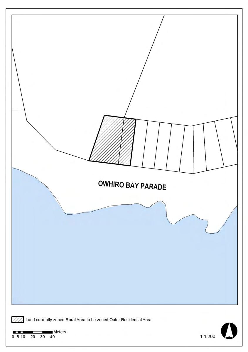
1 Section 32 Report WELLINGTON CITY DISTRICT PLAN PROPOSED DISTRICT PLAN CHANGE 54 REZONING 178 AND 180 OWHIRO BAY PARADE 1 Introduction Before a Proposed District Plan change is publicly notified the Council is required under section 32 of the Resource Management Act 1991 (the Act) to carry out an evaluation of the proposed change and prepare a report. As prescribed in section 32 of the Act: cheek An evaluation must examine: (a) the extent to which each objective is the most appropriate way to achieve the purpose of the Act; and (b) whether, having regard to their efficiency and effectiveness, the policies, rules, or other methods are the most appropriate for achieving the objectives. An evaluation must also take into account: (a) the benefits and costs of policies, rules, or other methods; and (b) the risk of acting or not acting if there is uncertain or insufficient information about the subject matter of the policies, rules or other methods. Benefits and costs are defined as including benefits and costs of any kind, whether monetary or non-monetary. A report must be prepared summarising the evaluation and giving reasons for the evaluation. The report must be available for public inspection at the time the proposed change is publicly notified. This Proposed Plan Change would change the current zoning of two sections, these being No. 178 and No. 180 Owhiro Bay Parade, located in Owhiro Bay, from Rural to Outer Residential. Wellington City Council owns the two sections, and has resolved to sell the land to provide funds for the Owhiro Bay Entrance upgrade. This section 32 report focuses on the appropriateness of the proposal to rezone the two properties in the Wellington City District Plan (refer to Location Plan attached as Appendix A). It does not address the issue of the sale of publicly owned land, as this is not a relevant matter for consideration under the Resource Management Act 1991.
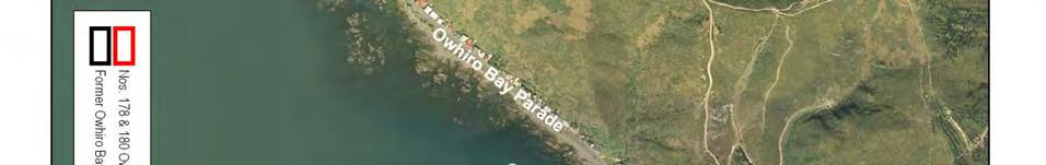
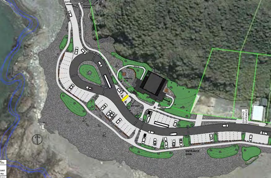
2 2. Background Owhiro Bay Quarry The South Coast is one of Wellington s most popular reserve areas with high ecological, landscape and recreational values. Activities undertaken in the area are wide ranging, including walking, running, mountain biking, fishing, diving, guided tours and off road vehicle use. Wellington City Council purchased the Owhiro Bay Quarry (located at the entrance to the South Coast recreational area), from Milburn New Zealand in The reason for the purchase was to stop quarrying on the South Coast, and to restore open space values and improve public access around the coast. Restoration and re-vegetation of the quarry has since been in progress in accordance with the Owhiro Quarry Closure Management Plan The final stage of the Quarry Closure Management Plan is the upgrade of the existing car park area to form the gateway to the South Coast. Upgrading the car park is also identified as a special project in the South Coast Management Plan refer Policy 8.1. A Concept Plan has been prepared for the proposed upgrade and this is attached as Appendix B. Key components of the upgrade include the removal of the majority of the Quarry building; improved traffic circulation and parking; landscaping; and the provision of public toilets, interpretation signage and information, seating and rubbish bins. A separate Plan Change (referred to as Proposed Plan Change 55) is proposed to rezone the wider ex quarry site from Rural to Open Space B (other than the two sections subject to this Proposed Plan Change). These two district plan changes will be publicly notified concurrently, as they both relate to the former Quarry site. A resource consent application will be lodged by the Council in the near future for the proposed car park upgrade. Description of the Two Sections No s 178 and 180 Owhiro Bay Parade are vacant sections located at the entrance (eastern end) of the ex Quarry as shown on Appendix C. The sections form the edge between the existing residential development and public open space. They are currently zoned Rural in conjunction with the remainder of the ex Quarry site to the west, with the hills to the north zoned Open Space B. To the east, the two sections adjoin a single row of residentially zoned properties located on the northern side of Owhiro Bay Parade. These properties are typically long and narrow, with dwellings located near the Owhiro Bay Parade frontage, and with steep hillside to the rear. The sections are held in separate certificates of title, being residential/rural-residential in size. No. 178 Owhiro Bay Parade (the eastern lot) is an irregular shaped lot with a frontage of approximately 12 metres, a depth of 47.5 metres, and an overall site area of 580m 2. No.180 Owhiro Bay Parade (the western lot) is significantly larger with frontage of 30 metres, a depth of 47.5 metre and an overall area of 1,192m 2. The front of both sections is level to approximately 15 metres (i.e. about a third of the
3 sites), with a re-vegetating coastal escarpment to the rear. The existing ex quarry building encroaches onto the south west corner of 180 Owhiro Bay Parade. The residential property immediately to the east of the sections (No.176) is currently vacant; however, the Council granted resource consent (SR ) on 28 August 2006, for the construction of a new residential building with associated earthworks on this site. It is noted that the two sections were previously zoned Residential in the former Wellington City Plan (1984), with the change to Rural zone occurring under the proposed District Plan (publicly notified in 1994). The reason why the zoning of the sections altered at that time was unable to be established with certainty from a search of the Council files. However, it is considered likely that change was made to reflect the use at that time of the two sections in conjunction with the wider former Quarry site. From a search of the Council records there appears to have been several commercial buildings on the two sites at various times, with alterations and additions to a lunch room in 1960 (on No. 178 Owhiro Bay Parade), a permit for an office hut in 1964 (on No. 178), and permit in 1978 for a workshop, office and store (on No. 180). 3. Process and Consultation The proposal to re-develop the former Milburn Quarry as the main entrance to the South Coast has been outlined above. Consultation on the proposed upgrade was held over eight weeks in The results from the consultation process were used to assist with the preparation of a design brief for the car park/visitor entrance upgrade and the resulting concept plan. A Council officer s report to the Strategy and Policy Committee, dated 22 September 2005, recommended that the two sections be declared surplus with an investigation into appropriate development restrictions being replaced on the titles. The recommendation was made on the basis that the loss of open space values with the sale and development of the two sections would be no more than minor. The Council decided on 23 November 2005 to reconsider the decision to sell the land after public consultation had been carried out. The resulting public consultation was held over a four week period (ending on 2 June 2006). It covered both the concept plan for the upgrade of the Owhiro Bay entrance, in addition to the possible sale of the two sections located within the wider Quarry site. A brochure describing the plans was widely distributed, with an opportunity to provide submissions. The brochure was sent to key stakeholders; copies were made available at the Council service centres, libraries and on the Council website; advertisements were placed in newspapers; and a sign erected in the Owhiro Quarry car park. A public information evening was also held on 23 May A total of 500 submissions were received on the proposal. 476 of the submissions supported the retention of the sections on the principle that the Council should not sell public land. The Committee voted to rezone the land to Outer Residential and to sell the sections (resolution on 19 June 2006). The scope of the Councils resolution also included the adoption of additional measures designed to mitigate potential adverse effects of
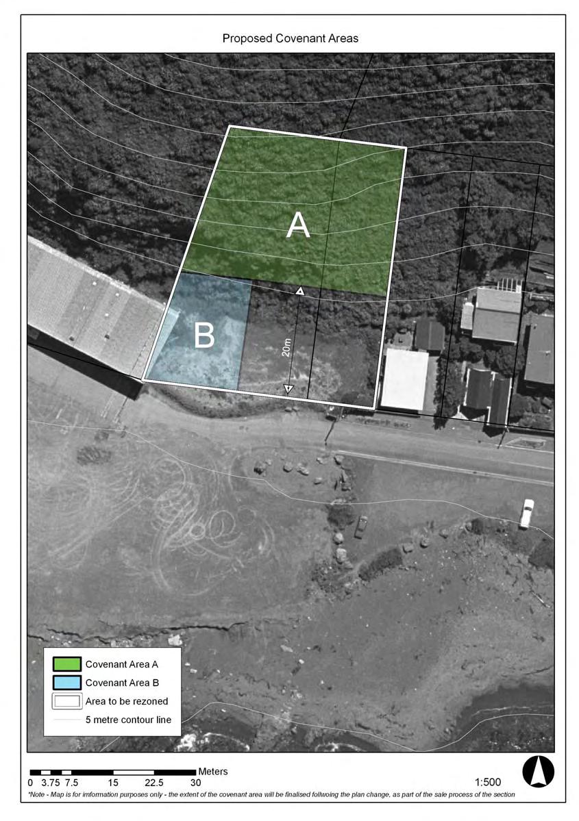
4 residential development. These measures include a covenant on the titles to protect the bush to the rear, a height restriction consistent with the provisions for the Outer Residential zone, and a boundary adjustment so that the sections would be a more even size (i.e. to reduce the size and development potential of No 180). The key potential environmental effects of the development of the two sections for residential use are the potential landscape effects on the residential and coastal character of the area. The development of the Proposed Plan Change has included commissioning an independent landscape architect to undertake further work on the landscape effects, to supplement the earlier in-house open space assessment (outlined in the 22 September 2005 Strategy and Policy Committee report). The landscape and visual assessment prepared by Boffa Miskell (dated January 2007), confirms that the two sites do not have significant landscape or ecological values, but they form part of the wider coastal landscape. The report emphasises the importance of ensuring that the development of the sites is of an appropriate form and scale in terms of the coastal landscape (and consistent with the intent and objectives of the South Coast Management Plan (which currently overlays the two sections). Of particular concern is that the relatively large size of the two sections proposed could enable the development of dwellings of that are significantly larger than the existing residences along Owhiro Bay Parade (notwithstanding the covenant to the rear protecting the escarpment from development). The report discusses examples present in the locality where recent residential development on sites with smaller buildable areas have not respected the existing coastal character. In addition, the importance of the sites as the edge of the new south coast gateway car parking/visitor facilities is highlighted, with the potential for the development of these sites to have a bearing on how visitors perceive the upgraded facilities as the start of their south coast recreation experience. For these reasons, the report recommends that in conjunction with the proposed change of zoning from Rural to Outer Residential Area, that further mitigation measures be adopted to supplement the controls proposed in the 19 June 2006 Council resolution. The recommended mitigation/control measures include: Configure the two future dwellings on the two sections so that they match the size and shape of other residential allotments along Owhiro Bay Parade Impose a height restriction consistent with the District Plan for the Outer Residential Area (i.e. 8m) by way of a covenant on the titles. This is consistent with the 19 June 2006 Council resolution. Protect the escarpment from disturbance and excavation (including the removal of vegetation unless it is removal of pest plants and replanting with local native species) for building purposes through a covenant on the titles. This is consistent with the 19 June 2006 Council resolution. Implement design controls on the form and design of new dwellings and the proposed materials to ensure that they are consistent with the South Coast Management Plan and reflect the prominent residential character of the
5 Owhiro Bay Parade. This could be achieved by requiring an assessment of the proposed buildings against a design guideline prepared by the Council, with the guideline forming part of the sale and purchase agreements and subsequently tied to the certificates of title. The design guideline would not be prescriptive, as a set of rules does not ensure a sensitive or innovative design response. The design guide would set out the intent and the guiding principles for the positioning and the form and design of buildings (including materials), to ensure that they reflect the coastal character and present an appropriate edge to the adjoining recreational area. Key Documents South Coast Management Plan, To protect and enhance the coastal character of Wellington s South Coast, prepared by Wellington City Council October Owhiro Bay Quarry Closure Management Plan 2000, prepared by Brian Bouzaid Wellington City Council, draft prepared 14 February Officers Report to the Strategy and Policy Committee Upgrade of the Owhiro Bay Quarry Carpark, prepared by Joanna Gillanders Open Space Planning Team Leader, dated 22 September 2005 Officers Report to the Strategy and Policy Committee Owhiro Bay Entrance- Reporting on Consultation Process of Possible Disposal of 178 and 180 Owhiro Bay Parade, prepared by Derek Fry Director of Recreation and Events and Joanna Gillanders; Open Space & Recreation Planning Manager, dated 15 June Wellington South Coast Owhiro Quarry Entrance Plan, prepared by C Gordon, Wellington City Council Owhiro Working Group, dated August Landscape and Visual Assessment, Plan Change request to rezone 178 and 180 Owhiro Bay Road from Rural to Outer Residential, prepared by Boffa Miskell, January 2007 Key Discussions/Briefings 23 May 2006: Public information evening on the concept for the upgrade of the Owhiro Bay entrance and the possible sale of the two sections. September 2006: Discussion with the Wellington Tenths Trust in relation to both the proposed re-zoning of the two sections, and the wider rezoning of the Quarry site and the car park upgrade.
6 December 2006: Discussion with Te Runanga o Toa Rangitira in relation to both the proposed re-zoning of the two sections and the wider rezoning of the Quarry site and the car park upgrade. Both the Wellington Tenths Trust and Te Runanga o Toa Rangitira have indicated that they generally support the zone changes; however, concerns have been expressed regarding the wider upgrade of the car park and the reserve status of the land. These concerns mainly relate to appropriate use of signage and recognition of Iwi association with the area. Theses issues will be dealt with as part of the resource consent process for the upgrade of the car park. Parks officers are currently working with Iwi to resolve these issues. Consultation, in accordance with the First Schedule of the RMA 1991 Ministry for the Environment Greater Wellington Regional Council Wellington Tenths Trust Te Runanga O Toa Rangitira Inc Department of Conservation 4. Appropriateness of the Objectives and Proposed Rezoning Resource Management Act The purpose of the RMA is to promote the sustainable management of natural and physical resources. Sustainable management includes managing the use and development of natural and physical resources to enable people to provide for their health and safety. With regard to this proposed Plan Change, the Act requires in relation to managing the use, development, and protection of natural and physical resources. Council shall recognise and provide for the following matters of national importance (section 6 RMA): (a) (b) (d) (e) The preservation of the natural character of the coastal environment (including the coastal marine area)., and the protection of them from inappropriate subdivision, use and development: The protection of outstanding natural features and landscapes from inappropriate subdivision, use and development; The maintenance and enhancement of public access to and along the coastal marine area, lakes and rivers; The relationship of Maori and their culture and traditions with their ancestral lands, water, sites, waahi tapu, and other taonga. In addition, Council shall have particular regard to the following other matters (section 7 RMA):
7 (b) (c) (f) the efficient use and development of natural and physical resources: the maintenance and enhancement of amenity values: maintenance and enhancement of the quality of the environment: Wellington City District Plan Chapter 4 of the District Plan sets out the objectives and policies for the use and development of Wellington s residential areas, and they reflect the matters that are required to be addressed under the RMA. In relation to this Plan Change the following Objectives and Policies are considered relevant: Objective Objective Policy Policy Objective Policy Policy Objective Policy Policy To promote the efficient use and development of natural and physical resources in Residential Areas. To maintain and enhance the amenity values of Residential Areas. Control the potential adverse effects of residential activities Manage any adverse effects of earthworks. To maintain and enhance natural features (including landscapes and ecosystems) that contribute to Wellington s natural environment. Protect significant escarpments, coastal cliffs and areas of open space from development and visual obstruction. Encourage retention of existing vegetation, especially established trees and existing native vegetation. To maintain and enhance the quality of the coastal environment within and adjoining Residential Areas. Enhance the natural values of the urban coastal environment by requiring developers to consider the ecological values that are present, or that could be enhanced on the site. Ensure that any developments near the coastal marine area are designed to maintain and enhance the character of the coastal environment. Summary It is not proposed to change any objectives or policies in the District Plan. The current objectives and policies remain relevant and are considered the most appropriate means of achieving the purposes of the Act in relation to the management of effects of development within Residential Areas.
8 5. Appropriateness of the Rules and Other Methods. Appropriateness of Zoning as a Method Zoning as a method of achieving the objectives and policies of the District Plan has been thoroughly considered though the plan preparation, submission and hearing process when the District Plan was originally notified. It is therefore not considered appropriate to revisit this general method, adopted widely in the District Plan as a key tool, in terms of this section 32 report. It is noted that zoning was also the primary tool used in the former Wellington City District Plan to secure the best pattern of landuse for the community. Zoning Options and other Methods Considered Having established that zoning is an appropriate method, the various options for zoning of the sections (and the associated rules that would apply as a result) that have been explored throughout the preparation of this Plan Change are discussed below. These zoning options have also been considered in some instances in conjunction with other non-regulatory controls. As previously noted, the Councils decision to sell publicly owned land, is not a relevant matter for consideration in terms of the Resource Management Act 1991, or this assessment undertaken in accordance with section 32 of that Act. Accordingly, the specific zoning options considered below are based on the premise that the sections will be sold as resolved by the Council. OPTION Option 1: Status Quo sell the sections with the existing Rural zoning This option is NOT RECOMMENDED Option 2: Zone the two sections Outer Residential and rely on the controls in the district plan This option is NOT RECOMMENDED EVALUATION Benefits Avoids the costs associated with the Plan Change process. Costs This is not an appropriate zoning for small sections - the sections are too small and physically constrained to be practically utilised for rural purposes in accordance with the zoning. Any proposed development for residential use would require a resource consent with the associated costs and potential time delays associated with that process and no certainty of outcome. Does not protect the coastal escarpment from earthworks or vegetation removal. Benefits Enables the development of two additional dwellings potentially as of right Certainty to future purchasers i.e. dwellings could be constructed as a permitted activity The level of control on building development is consistent with adjoining residential sites & clearly set out in the District Plan. New dwellings will overlook the upgraded car
9 park/visitor facilities with advantages in terms of security and supervision of the facility. Extension of the Residential zone adjoining existing residential sites, and onto previously zoned and considered appropriate for residential use. Costs Potentially could result in adverse landscape effects & loss of recreational values Does not protect the coastal escarpment from earthworks or vegetation removal. Potential effects from the development of the sites for residential use on the adjoining neighbours may not be totally avoided through reliance on the district plan rules, i.e. possible shading, privacy, loss of views. Option 3: Split zone - zone the lower half of the two sections Outer Residential and the escarpment Open Space B. This option is NOT RECOMMENDED Option 4: Zone the two sections Outer Residential, in conjunction with the following additional non-regulatory controls Locate the proposed new dwelling at No 180 Owhiro Bay Parade on the eastern half of the section, adjacent to No 178 Protect the escarpment (and Benefits Provides for the protection of the coastal escarpment through the Open Space B zoning. Minimises the risk of an inappropriate scale of development and impacts on neighbouring properties being undertaken as of right due to significantly reduced section sizes (particularly for No 178 which immediately adjoins a residential neighbour) - compared with Options 2 and 3. Extension of the Residential Zone adjoining an existing zone, and on land previously zoned and considered appropriate for residential use. Costs Generally not good planning practice to split zones across property boundaries as the demarcation line is not easily identifiable compared with certificate of title boundaries. Generally not good planning practice to apply Open Space zonings (designed to provide for public open space and facilities) over private land. Benefits Minimises risk of inappropriate development and impacts on the overall streetscape and landscape Provides for protection of the coastal escarpment Enables the development of additional dwellings potentially as of right Certainty to future purchasers i.e. dwellings could be constructed as a permitted activity New dwellings will overlook the upgraded car park/visitor facilities, with advantages in terms of security and supervision of the facility. Provides a buffer between the new dwellings and the car park /visitor facilities.
10 associated vegetation) through a covenant on the bush to the rear of the two sections and on the area between the dwelling at No 180 and the car park/visitor facilities to the west (refer Appendix D) Place height restriction on any future development consistent with the Outer Residential rules Extension of the Residential Zone adjoining existing residential sites, and onto previously zoned and considered appropriate for residential use. Costs Potentially could result in adverse landscape effects and loss of recreational values, however the risk has been significantly mitigated through the proposed controls Impose design controls on the new dwellings to ensure they in keeping with the size and shape of other residential allotments along Owhiro Bay Parade This is the RECOMMENDED Option 6.0 The Risk of Acting or Not Acting The evaluation under section 32 must consider the risk of acting or not acting if there is uncertain or insufficient information about the subject matter of the proposed District Plan approach. In this case, it is considered that there is sufficient information available to analyse the issues and to evaluate the benefits and costs of the policies, rules and methods considered. As a consequence it is also considered that there is a very low risk of any untoward outcomes resulting from the implementation and application of the provisions proposed to address the identified issues. 7.0 Conclusion Each of the options outlined above have advantages and disadvantages. On balance it is considered that a Residential zoning for the sites, in conjunction with the other methods set out in either Option 4, will be the most efficient and effective means of meeting the requirements under Part 2 of the RMA, and the objectives and policies of the District Plan. In particular Options 4 will enable an appropriate development potential of the land (efficient use and development of natural and physical resources), while retaining the natural values of the coastal landscape, avoiding adverse impacts on the future recreational values of the proposed car park/visitor area upgrade, protecting the coastal escarpment from development, and minimising the likelihood of adverse effects for adjoining residential neighbours. 8.0 Recommended Proposed Plan Change It is recommended that the Council notify the following District Plan Change 54:
11 Change the zoning of 178 and 180 Owhiro Bay Parade from Rural to Outer Residential. In addition, it is recommended that the Council adopts the additional controls as outlined for Option 4.
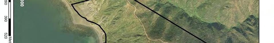
12 APPENDIX A Location Plan


13
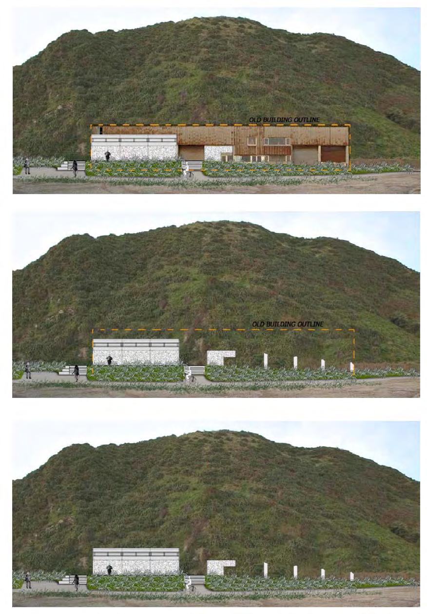
14 APPENDIX B Wellington South Coast Owhiro Bay Entrance Plan
15
16
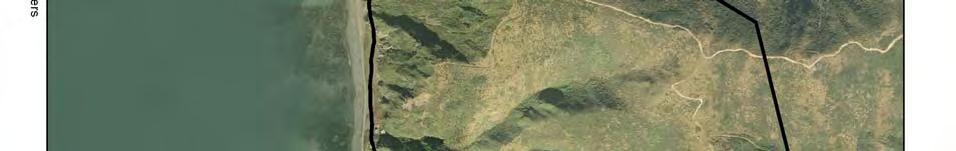
17 APPENDIX C Proposed Plan Change 54 - Rezoning of 178 and 180 Owhiro Bay Parade
18
19 APPENDIX D Proposed covenant areas
20
Guidance Notes Completing an AEE
 Guidance Notes Completing an AEE The purpose of this guidance note is to assist you with completing your Assessment of Environmental Effects (AEE) for your land-use consent application. If you do not provide
H7 Open Space zones. (a) provide for the needs of the wider community as well as the needs of the community in which they are located;
 provide for the needs of the wider community as well as the needs of the community in which they are located;") H7. Open Space zones H7.1. Background The majority of land zoned as open space is vested in the Council or is owned by the Crown. However some areas zoned open space are privately owned. While the open
H7. Open Space zones H7.1. Background The majority of land zoned as open space is vested in the Council or is owned by the Crown. However some areas zoned open space are privately owned. While the open
Managing Fire Risk for New Rural Dwellings
 Managing Fire Risk for New Rural Dwellings Policy Options Paper Draft Proposed Changes to the Tasman Resource Management Plan For Public Consultation December 2011 January 2012 Executive Summary The current
4 RESIDENTIAL ZONE. 4.1 Background
 4 RESIDENTIAL ZONE 4.1 Background The residential areas within the City are characterised by mainly lowrise dwellings sited on individual allotments. Past architectural styles, settlement patterns and
Section 6A 6A Purpose of the Natural Features and Landscapes Provisions
 Section 6A 6A Purpose of the Natural Features and Landscapes Provisions This Chapter addresses the protection and management of natural features and landscapes within the City. The City has a number of
TAURANGA CITY COUNCIL CITY PLAN SECTION 32 REPORT. Chapter 16 Rural Zones
 125 TAURANGA CITY COUNCIL CITY PLAN SECTION 32 REPORT Chapter 16 Rural Zones Table of Contents 1. INTRODUCTION... 3 2. PURPOSE OF THE CHAPTER... 3 3. RECORD OF DEVELOPMENT OF PROVISIONS... 4 3.1 Background
I539. Smales 2 Precinct
 I539. Smales 2 Precinct I539.1. Precinct Description The Smales 2 Precinct applies to a 4.8 hectare block of land located on the southern side of Northcote Road and fronting Lake Pupuke, Takapuna. The
PART 5 - NATURAL AND PHYSICAL ENVIRONMENT
 CONTENTS...PAGE 5.1 INTRODUCTION...3 5.2 NATURAL RESOURCES...4 5.3 PHYSICAL RESOURCES...4 5.4 COASTAL ENVIRONMENT...4 5.5 HERITAGE FEATURES...4 5.6 HAZARDS...4 5.7 SUMMARY...4 ISTHMUS SECTION - OPERATIVE
D10. Outstanding Natural Features Overlay and Outstanding Natural Landscapes Overlay
 D10. Outstanding Natural Features Overlay and Outstanding Natural Landscapes Overlay D10.1. Background These provisions give effect to Policy 15(a) of the New Zealand Coastal Policy Statement 2010, and
D10. Outstanding Natural Features Overlay and Outstanding Natural Landscapes Overlay
 D10. Outstanding Natural Features Overlay and Outstanding Natural Landscapes Overlay D10.1. Background These provisions give effect to Policy 15(a) of the New Zealand Coastal Policy Statement 2010, and
SECTION 2.4 URBAN DEVELOPMENT AND STRATEGIC URBAN DIRECTIONS
 SECTION 2.4 URBAN DEVELOPMENT AND STRATEGIC URBAN DIRECTIONS 2.4.1 INTRODUCTION In 1993/94 the Hastings District Council completed the Hastings Urban Development Strategy. The purpose of this study was:
CA.1 Coastal Area. Index. CA.1.1 Description and Expectations
 Index.1.2.3.4 CA.2 CA.2.1 CA.2.2 CA.2.3 CA.3 CA.3.1 CA.3.2 CA.3.1 CA.4 CA.4.1 CA.4.2 CA.4.3 CA.4.4 CA.5 CA.5.1 CA.5.2 Description and Expectations Objectives Policies Guidance Note Landuse Eligibility
Section 3b: Objectives and Policies Rural Environment Updated 19 November 2010
 Page 1 of Section 3b 3b RURAL ENVIRONMENT 3b.1 Introduction The Rural Environment comprises all the land outside of the Residential, Town Centre and Industrial Environments. Most land within the District
open space environment
 This section updated August 09 GUIDELINE TO THE RULES The Open Space Environment Rules apply to activities on sites within the Open Space Environment as shown on the Human Environments Maps. Most of the
2A District-wide Policies
 2A Introduction This Chapter contains policies which are relevant to subdivision, use and development activities occurring across all zones and areas of the District. The policies in this Chapter implement
4 Residential and Urban Living Zones
 4 Residential and Urban Living Zones Refer to Chapters 11 to 20 for additional rules that may apply to these zones. 4.1 OBJECTIVES AND POLICIES Objective Res1 Policy 1 Policy 2 Policy 3 Policy 4 Policy
SECTION ONE North East Industrial Zone Design Guide Palmerston North City Council June 2004
 SECTION ONE North East Industrial Zone Design Guide Palmerston North City Council June 2004 young heart easy living 1 Preface Industrial areas are a very important component of the economic well-being
WELLINGTON CITY COUNCIL REPORT OF THE HEARING COMMITTEE SUBJECT: PROPOSED DISTRICT PLAN CHANGE 47:TAKAPU ISLAND REZONING
 Approved by Council - 10 October 2007 WELLINGTON CITY COUNCIL REPORT OF THE HEARING COMMITTEE SUBJECT: PROPOSED DISTRICT PLAN CHANGE 47:TAKAPU ISLAND REZONING COMMITTEE MEMBERS: CRS Foster (Chair) McKinnon
Ensure that development within the Arrowtown Urban Growth Boundary provides:
 URBAN DEVELOPMENT 4 4.2.5.2 Ensure that development within the Arrowtown Urban Growth Boundary provides: an urban form that is sympathetic to the character of Arrowtown, including its scale, density, layout
Appendix A. Planning Processes. Introduction
 1 Planning Processes Introduction This appendix outlines a number of planning processes which are used in the Auckland Region to support the effective management of development in the region s rural and
PUBLIC NOTICE UNDER CLAUSE 5 OF SCHEDULE 1 OF THE RESOURCE MANAGEMENT ACT 1991 PLAN CHANGE 12 TO THE OPERATIVE CITY OF NAPIER DISTRICT PLAN
 PUBLIC NOTICE UNDER CLAUSE 5 OF SCHEDULE 1 OF THE RESOURCE MANAGEMENT ACT 1991 PLAN CHANGE 12 TO THE OPERATIVE CITY OF NAPIER DISTRICT PLAN Public notice is given in accordance with Clause 5 of Schedule
MERIDAN PLAINS SAND RESOURCE AREA
 MERIDAN PLAINS SAND RESOURCE AREA INFORMATION SHEET October 2010 BACKGROUND The Meridan Plains Extractive Resource Area is located on the western fringe of the coastal urban communities of Caloundra West
STAGE 3 - SECTION 32 CHAPTER 9 NATURAL AND CULTURAL HERITAGE
 STAGE 3 - SECTION 32 CHAPTER 9 NATURAL AND CULTURAL HERITAGE Notified 25 July 2015 Contents 1 INTRODUCTION AND STRATEGIC CONTEXT 3 1.1 INTRODUCTION 3 1.2 PURPOSE AND SCOPE OF THE NATURAL AND CULTURAL HERITAGE
RURAL ZONE - POLICY. Rural Zone Policy. Issue: Rural Environment. Ruapehu District Plan Page 1 of 8
 Rural Zone Policy RU2 RURAL ZONE - POLICY RU2.1 Introduction The natural resources of the rural environment in the Ruapehu District provide the basis for the existing and potential character, intensity
9.1 ISSUES OBJECTIVES RULES - Class B - Heritage Items RULES - Class C - Heritage Items RULES - Old Town Overlay Area 18
 9 HISTORIC HERITAGE 9.1 ISSUES 7 9.2 OBJECTIVES 7 9.3 POLICIES 8 9.4 RULES - Class A - Heritage Items 13 9.5 RULES - Class B - Heritage Items 15 9.6 RULES - Class C - Heritage Items 17 9.7 RULES - Old
Historic Heritage Historic Heritage Explanatory Statement Significant Issues Objectives and Policies...
 Section Contents Historic Heritage... 2 7. Historic Heritage... 2 Explanatory Statement... 2 7.1 Significant Issues... 3 7.2 Objectives and Policies... 3 7.3 Activity Lists... 4 7.4 Matters of Control
CITY OF NAPIER DISTRICT PLAN. The following resource management issues have been identified as significant:
 Chapter 56 HERITAGE 56.1 RESOURCE MANAGEMENT ISSUES The following resource management issues have been identified as significant: 56.1.1 The possibility of the loss of identified heritage features through
Chapter 3: Natural Environment. Proposed Waikato District Plan Stage 1. (Notified version)
") Chapter 3: Natural Environment Proposed Waikato District Plan Stage 1 Page 2 of 7 Contents Chapter 3: Natural Environment... 3 3.1 Indigenous Vegetation and Habitats... 3 3.1.1 Objective Biodiversity and
Chapter 3: Natural Environment Proposed Waikato District Plan Stage 1 Page 2 of 7 Contents Chapter 3: Natural Environment... 3 3.1 Indigenous Vegetation and Habitats... 3 3.1.1 Objective Biodiversity and
Proposed Southland District Plan 2012 Appeal Version October 2016
 S e c t i o n 3. 5 - F i o r d l a n d / R a k i u r a Z o n e The Fiordland/Rakiura Zone encompasses the Fiordland and Rakiura National Parks and part of Mt Aspiring National Park. It also includes areas
LANDSCAPE GUIDELINES. Countryside & Coastal Countryside Environments. Landscape, Natural Character & Amenity Values Guide
 Landscape, Natural Character & Amenity Values Guide Copyright WDC 2009 Version A2 18May09 Environmental Services Group Publication Countryside & Coastal Countryside Environments START HERE Quality Land
B4. Te tiaki taonga tuku iho - Natural heritage
 B4. Te tiaki taonga tuku iho - Natural heritage Tuia I runga, tuia i raro, tuia ki te waonui a Tiriwa Bind the life forces of heaven and earth to the great realm of Tiriwa B4.1. Issues Auckland s distinctive
15 Rural Residential Zone
 15 Rural Residential Zone Section 15A 15A Purpose of the Rural Residential Zone... 1 15A.1 Objectives and Policies of the Rural Residential Zone... 1 15A.2 Activity Status Rules... 5 15A.3 Permitted Activity
Appendix 1 Structure plan guidelines
 Appendix 1 Structure plan guidelines This appendix forms part of the regional policy statement [rps]. 1.1. Introduction Structure plans are an important method for establishing the pattern of land use
Section 32 report: Natural heritage for the Proposed Natural Resources Plan for the Wellington Region
 Section 32 report: Natural heritage for the Proposed Natural Resources Plan for the Wellington Region Issues and Evaluation Report Section 32 report: Natural heritage for the Proposed Natural Resources
64 Mineral Extraction Area Rules
 64 Mineral Extraction Area Rules 64.1 Introduction For the purposes of this Chapter: Active Area, in relation to a Mineral Extraction Area (MEA), is that part of the Mineral Extraction Area which is owned
E15. Vegetation management and biodiversity
 E15. management and biodiversity E15.1. Background contributes to a range of ecosystem services such as erosion and sediment control, reducing stormwater flows, protecting or enhancing water quality, amenity
Section Three, Part 16 Takanini Structure Plan Area
 PART 16 TAKANINI STRUCTURE PLAN AREA 16.1 Residential 8 zone 16.1.1 Objectives and Policies 16.1.2 Rules: General 16.1.3 Rules: Activity Status Subdivision (Except within the Addison Neighbourhood Centre)
Section Three, Appendix 17C Multiple Unit Housing Design Assessment Criteria
 APPENDIX 17C MULTIPLE UNIT HOUSING DESIGN ASSESSMENT CRITERIA Purpose of Appendix 17C In the Residential 9 Zone the construction and use of multiple household units located within the Multiple Household
SECTION 7A: WHAKARONGO RESIDENTIAL AREA
 SECTION 7A: WHAKARONGO RESIDENTIAL AREA CONTENTS 7A.1 Introduction 1 7A.2 Resource Management Issues 1 7A.3 Objectives and Policies 1 7A.4 Methods 4 7A.5 Residential Zone 4 7A.5.1 Rules: Controlled Activities
Planning Proposal Toronto Road, Booragul. Amendment to Lake Macquarie Local Environmental Plan (LMLEP) 2014
 2014") Planning Proposal Toronto Road, Booragul Amendment to Lake Macquarie Local Environmental Plan (LMLEP) 2014 Local Government Area: Name of Draft LEP: Subject Land: Land Owner: Applicant: Folder Number:
Planning Proposal Toronto Road, Booragul Amendment to Lake Macquarie Local Environmental Plan (LMLEP) 2014 Local Government Area: Name of Draft LEP: Subject Land: Land Owner: Applicant: Folder Number:
RESIDENTIAL ACTIVITY PERFORMANCE STANDARDS
 Preferred Options Consultation Q&A Sheet RESIDENTIAL ACTIVITY PERFORMANCE STANDARDS What are the key goals for managing the design of residential buildings in the Second Generation Plan (2GP)? The key
Section Three, Appendix 16C Medium Density Housing, Design Assessment Criteria (Residential 8A zone)
") APPENDIX 16C MEDIUM DENSITY HOUSING, DESIGN ASSESSMENT CRITERIA (RESIDENTIAL 8A ZONE) PURPOSE OF APPENDIX 16C (RESIDENTIAL 8A ZONE) In the Residential 8A Zone the following are defined as restricted discretionary
APPENDIX 16C MEDIUM DENSITY HOUSING, DESIGN ASSESSMENT CRITERIA (RESIDENTIAL 8A ZONE) PURPOSE OF APPENDIX 16C (RESIDENTIAL 8A ZONE) In the Residential 8A Zone the following are defined as restricted discretionary
GIBBSTON CHARACTER ZONE. QLDC PROPOSED DISTRICT PLAN [PART FOUR] AUGUST gibbston character zone
![GIBBSTON CHARACTER ZONE. QLDC PROPOSED DISTRICT PLAN [PART FOUR] AUGUST gibbston character zone](/thumbs/75/72573993.jpg "GIBBSTON CHARACTER ZONE. QLDC PROPOSED DISTRICT PLAN [PART FOUR] AUGUST gibbston character zone") 23 GIBBSTON CHARACTER ZONE QLDC PROPOSED DISTRICT PLAN [PART FOUR] AUGUST 2015 23 gibbston character zone QLDC PROPOSED DISTRICT PLAN [PART FOUR] AUGUST 2015 23 gibbston character zone 23.1 Zone Purpose
23 GIBBSTON CHARACTER ZONE QLDC PROPOSED DISTRICT PLAN [PART FOUR] AUGUST 2015 23 gibbston character zone QLDC PROPOSED DISTRICT PLAN [PART FOUR] AUGUST 2015 23 gibbston character zone 23.1 Zone Purpose
Appendix 7 Precinct Analysis Carlton
 Appendix 7 Precinct Analysis Carlton (Andover Street) Rezone from R2 Low Density Residential to R3 Medium Density Residential Retain existing B1 Neighbourhood Centre zone Existing Zoning Map (R2 Low Density
Rural (Urban Expansion) Environment
 Environment") RUEE.1 Rural (Urban Expansion) Environment Subsequent to the receipt of appeals, a 'marked up' version of the Proposed District Plan was prepared. The provisions of the Proposed Version of the Plan subject
RUEE.1 Rural (Urban Expansion) Environment Subsequent to the receipt of appeals, a 'marked up' version of the Proposed District Plan was prepared. The provisions of the Proposed Version of the Plan subject
Memorial Business Park Site. Proposed Future Development. Design guidelines. August
 Memorial Business Park Site Proposed Future Development Design guidelines August 2014 www.designenvironment.co.nz 0064 3 358 3040 Contents 1.0 Background 1.1 Introduction 3 1.2 Objectives 4 2.0 Context
Edward R. Sajecki Commissioner of Planning and Building. Land Use Review- Former Parkway Belt West Lands- Fieldgate Drive and Audubon Boulevard
 Corporate Report Clerk s Files Originator s Files CD.04.FOR DATE: November 15, 2011 TO: FROM: SUBJECT: Chair and Members of Planning and Development Committee Meeting Date: December 5, 2011 Edward R. Sajecki
Design and siting guidelines
 Design and siting guidelines Enhance your lifestyle Callaway Park an development 1 These Guidelines deal with the planning and development of the vacant residential land lots at Callaway Park. 2 Introduction
Rural (Urban Expansion) Environment
 Environment") RUEE.1 Rural (Urban Expansion) Environment Index RUEE.1 RUEE.1.1 RUEE.1.2 RUEE.1.3 RUEE.1.4 RUEE.2 RUEE.2.1 RUEE.2.2 RUEE.2.3 RUEE.2.4 RUEE.3 Rural (Urban Expansion) Environment Description and Expectations
RUEE.1 Rural (Urban Expansion) Environment Index RUEE.1 RUEE.1.1 RUEE.1.2 RUEE.1.3 RUEE.1.4 RUEE.2 RUEE.2.1 RUEE.2.2 RUEE.2.3 RUEE.2.4 RUEE.3 Rural (Urban Expansion) Environment Description and Expectations
Lake Macquarie City. A copy of the published amendment including the instrument and maps, is provided in Attachment 7 of this report.
 Planning Proposal Amendment No. 77 to Lake Macquarie Local Environmental Plan 2004 and proposed Amendment to Draft Lake Macquarie Local Environmental Plan 2013 Minor Zone Boundary Adjustment - Pasminco
medium desnity housing
 This section updated September 2013 This part of the Plan sets out the assessment criteria for medium density housing. The criteria are designed to give designers and builders flexibility and to provide
Tāhuhu whakaruruhau ā-taone The sheltering ridge pole
 B2. Tāhuhu whakaruruhau ā-taone - Urban growth and form B2.1. Issues Tāhuhu whakaruruhau ā-taone The sheltering ridge pole Auckland s growing population increases demand for housing, employment, business,
Section 12C Subdivision in the Rural Residential Zone
 Section 12C 12C Subdivision in the Rural Residential Zone The Rural Residential Zone provides part of the range of residential opportunities within the City. Land zoned rural residential is considered
SECTION 32 SUBDIVISION, DEVELOPMENT AND EARTHWORKS
 SECTION 32 SUBDIVISION, DEVELOPMENT AND EARTHWORKS 1 Section 32 Report Publicly Notified on 27 August 2014 CONTENTS 1. STRATEGIC CONTEXT... 3 2. RESOURCE MANAGEMENT ISSUES... 6 3. SCALE AND SIGNIFICANCE
Neighbourhood Plan Representation
 Date: 10 th November 2017 Neighbourhood Plan Representation Land to the east of Callow Hill Road, Alvechurch Introduction This representation has been prepared by RPS Planning and Development on behalf
Plan Modification to Chapter B2 of the Auckland Unitary Plan(AUP) Operative in part (15 November 2016)
 Operative in part (15 November 2016)") UNITARY PLAN UPDATE REQUEST MEMORANDUM TO FROM Phill Reid Linley Wilkinson DATE 25 September 2018 SUBJECT Plan Modification to Chapter B2 of the Auckland Unitary Plan(AUP) Operative in part (15 November
UNITARY PLAN UPDATE REQUEST MEMORANDUM TO FROM Phill Reid Linley Wilkinson DATE 25 September 2018 SUBJECT Plan Modification to Chapter B2 of the Auckland Unitary Plan(AUP) Operative in part (15 November
Planning Proposal Charlestown Swim and Leisure Centre LEP Amendment
 Planning Proposal Charlestown Swim and Leisure Centre LEP Amendment Amendment No. 4 to Lake Macquarie Local Environmental Plan 2014 (PP_2014_LAKEM_005_00) Local Government Area: Name of Draft LEP: Lake
South of Eastern Strategic Direction Status Update
 STAFF REPORT ACTION REQUIRED South of Eastern Strategic Direction Status Update Date: July 10, 2014 To: From: Planning and Growth Management Committee Chief Planner and Executive Director, City Planning
P art B 10 HERITAGE VALUES. Community Enablement and Physical Resources ISSUE
 10 HERITAGE VALUES ISSUE There is growing public concern within the District at the loss of heritage sites and places, and of the need for the recognition and protection of heritage and cultural values
Section 32 Evaluation Report Variation 1 - Arrowtown Design Guidelines, 2016 Contents
 Section 32 Evaluation Report Variation 1 - Arrowtown Design Guidelines, 2016 Contents Section 32 Evaluation Report: Variation 1 - Arrowtown Design Guidelines, 2016 (ADG, 2016)... 3 1. Strategic Context...
Tennis Court Rear Of 3-5 Corringway London NW11 7ED
 Location Tennis Court Rear Of 3-5 Corringway London NW11 7ED Reference: 18/4122/FUL Received: 3rd July 2018 Accepted: 3rd July 2018 Ward: Garden Suburb Expiry 28th August 2018 Applicant: Ms Sarah Robinson
I Te Koti Taiao o Aotearoa Ōtautahi Rohe ENV-2018-CHC- Appellant. Queenstown Lakes District Council. Respondent
 In the Environment Court of New Zealand Christchurch Registry I Te Koti Taiao o Aotearoa Ōtautahi Rohe ENV-2018-CHC- Under In the matter of Between the Resource Management Act 1991 (RMA) An appeal under
PART 3 - RESOURCE MANAGEMENT
 CONTENTS... PAGE 3.1 INTRODUCTION... 3 3.2 NATURAL AND PHYSICAL ENVIRONMENT... 3 3.3 URBAN SUSTAINABLE MANAGEMENT... 5 3.4 RESOURCE MANAGEMENT ISSUES... 5 3.5 RESOURCE MANAGEMENT OBJECTIVES AND POLICIES...
RLE.1 Rural Living Environment
 Index.1 Description and Expectations.2 Objectives.3 Policies.4 Guidance RLE.2 Landuse RLE.2.1 Eligibility Rules RLE.2.2 Notification Rules RLE.2.3 Discretionary Activities RLE.3 Subdivision RLE.3.1 Eligibility
I615. Westgate Precinct
 I615. Westgate Precinct I615.1. Precinct Description The Westgate Precinct is located approximately 18km west of the Auckland city centre. There are seven Sub-precincts in the Westgate Precinct: Sub-precinct
QUEENSTOWN LAKES DISTRICT COUNCIL
 QUEENSTOWN LAKES DISTRICT COUNCIL Hearing of Submissions on the Proposed District Plan Report 16.8 Report and Recommendations of Independent Commissioners Regarding Upper Clutha Planning Maps Church Road,
Section 32 Report Part 2. Landscape & Natural Character. Proposed Waikato District Plan
 Section 32 Report Part 2 Landscape & Natural Character prepared for the Proposed Waikato District Plan July 2018 2 TABLE OF CONTENTS 1 OVERVIEW AND PURPOSE...4 1.1 Topic Description...4 1.2 Significance
The Proposed Auckland Unitary Plan (notified 30 September 2013)
") 3 Business zones Introduction There are 10 business zones in the Unitary Plan: City Centre Metropolitan Centre Town Centre Local Centre Neighbourhood Centre Mixed Use General Business Business Park Light
3 Business zones Introduction There are 10 business zones in the Unitary Plan: City Centre Metropolitan Centre Town Centre Local Centre Neighbourhood Centre Mixed Use General Business Business Park Light
AUCKLAND COUNCIL DISTRICT PLAN PAPAKURA SECTION
 AUCKLAND COUNCIL DISTRICT PLAN PAPAKURA SECTION OPERATIVE 16 JUNE 1999 D P Hawkins, Mayor T McLean, Chief Executive Officer Given under the Common Seal of the Papakura District Council this 16th day of
Ebbsfleet Development Corporation
 Title of Paper Planning and Housing Delivery Report September 2018 Presented by Sub-Committee Mark Pullin, Chief Planning Officer Planning Committee Purpose of Paper and Executive Summary This paper provides
APPENDIX F: EXTERNAL APPROVALS
 1.0 RESPONSIBILITIES When the City is constructing the Park or Open Space Development lands (OPTION I), after the subdivision construction process is completed by the Developer, Open Space Development
Bill Stockman PROPOSED SHED PLANNER S REPORT & ASSESSMENT OF ENVIRONMENTAL EFFECTS
 Thomson Survey Limited Shed Land Use Proposal January-19 Bill Stockman PROPOSED SHED 798D Taupo Bay Road PLANNER S REPORT & ASSESSMENT OF ENVIRONMENTAL EFFECTS Thomson Survey Ltd Kerikeri 1.0 INTRODUCTION
STRATEGIC DIRECTION. QLDC PROPOSED DISTRICT PLAN [PART TWO] DECISIONS VERSION 3 strategic direction
![STRATEGIC DIRECTION. QLDC PROPOSED DISTRICT PLAN [PART TWO] DECISIONS VERSION 3 strategic direction](/thumbs/79/79711764.jpg "STRATEGIC DIRECTION. QLDC PROPOSED DISTRICT PLAN [PART TWO] DECISIONS VERSION 3 strategic direction") 3 STRATEGIC DIRECTION QLDC PROPOSED DISTRICT PLAN [PART TWO] DECISIONS VERSION 3 strategic direction QLDC DISTRICT PLAN [PART TWO] AUGUST 2015 3 strategic direction 3.1 Purpose This chapter sets out the
3 STRATEGIC DIRECTION QLDC PROPOSED DISTRICT PLAN [PART TWO] DECISIONS VERSION 3 strategic direction QLDC DISTRICT PLAN [PART TWO] AUGUST 2015 3 strategic direction 3.1 Purpose This chapter sets out the
Derry City and Strabane District Council Planning Committee Report
 Derry City and Strabane District Council Planning Committee Report COMMITTEE DATE: 23 rd March 2016 APPLICATION No: APPLICATION TYPE: PROPOSAL: LOCATION: APPLICANT: LA11/2015/0395/F Residential Development
Presentation of the Staff Draft. July 17, 2014 SSRVP Team, Area 3
 Presentation of the Staff Draft July 17, 2014 SSRVP Team, Area 3 Presentation Overview Introduction Plan Framework Plan Recommendations Implementation Next Steps and Request for Public Hearing on September
Understanding Wellington City s DISTRICT PLAN
 Understanding Wellington City s DISTRICT PLAN Wellington City Council 1 UNDERTANDING WELLINGTON CITY S DISTRICT PLAN CONTENTS 1. Introduction...3 1.1. Overview of this Guide...3 1.2. What is the District
What progress have we made so far? NEWSLETTER PROPOSED IONA RESIDENTIAL DEVELOPMENT UPDATE
 MAY 2017 NEWSLETTER PROPOSED IONA RESIDENTIAL DEVELOPMENT UPDATE The Iona Working Group has been set up to encourage discussions between the parties involved in the Environment Court Process. This newsletter
24. ARCHAEOLOGY & BUILT HERITAGE
 24. ARCHAEOLOGY & BUILT HERITAGE Overview There are no known archaeological or built heritage sites within or adjacent to the Project designation boundaries. There is a history of both Māori and European
Planning Proposal Concurrent DA/LEP Amendment for Belmont North Pharmacy Amendment No. 24 to Lake Macquarie Local Environmental Plan (LMLEP) 2014
 2014") Planning Proposal Concurrent DA/LEP Amendment for Belmont North Pharmacy Amendment No. 24 to Lake Macquarie Local Environmental Plan (LMLEP) 2014 Local Government Area: Name of Draft LEP: Subject Land:
Planning Proposal Concurrent DA/LEP Amendment for Belmont North Pharmacy Amendment No. 24 to Lake Macquarie Local Environmental Plan (LMLEP) 2014 Local Government Area: Name of Draft LEP: Subject Land:
To provide background into Council's involvement with Ngai Tamarawaho with regard to the development of the Kopurererua Valley ('K Valley') Reserve.
 Reserve.") 13 Taurant^aOty Kopurererua Valley Reserve Development DC No: 307 Purpose To provide background into Council's involvement with Ngai Tamarawaho with regard to the development of the Kopurererua Valley
13 Taurant^aOty Kopurererua Valley Reserve Development DC No: 307 Purpose To provide background into Council's involvement with Ngai Tamarawaho with regard to the development of the Kopurererua Valley
Subdivision Design Criteria. Penihana North GUIDELINES TO THE RULES
 Created September 2013 Penihana North Subdivision Design Criteria GUIDELINES TO THE RULES This part of the Plan sets out the design criteria for subdivision in Penihana North. The criteria will be considered
Report to COUNCIL for decision
 17 058 Title: Section: Prepared by: Urban Design Plan Guidelines Strategic Planning Janic Slupski (Policy Planner) Meeting Date: 23 February 2017 Report to COUNCIL for decision Legal Financial Significance
AOTEA SUPERMARKET ZONE. Zone Introduction
 C18 AOTEA SUPERMARKET ZONE Zone Introduction C18.1 Objective This zone identifies a specific area in Aotea for a stand alone supermarket. The zone is site specific and has a range of objectives, policies
Rev John Withy, Sion House, 120 Melmount Road, Sion Mills
 Derry City and Strabane District Council Planning Committee Report COMMITTEE DATE: 4 th October 2017 APPLICATION No: APPLICATION TYPE: PROPOSAL: LOCATION: APPLICANT: AGENT: LA11/2016/0701/F Full Retrospective
1 INTRODUCTION TO NATURAL ENVIRONMENT
 Kāpiti Coast District Plan Review Section 32 Analysis Summary Report 1 INTRODUCTION TO NATURAL ENVIRONMENT Diverse landscapes, plants and animals make up the natural environment of the District. Much has
11.3 SPECIAL CHARACTER ZONE HAWKE S BAY REGIONAL SPORTS PARK
 11.3 SPECIAL CHARACTER ZONE HAWKE S BAY REGIONAL SPORTS PARK 11.3.1 INTRODUCTION The availability of sports and recreation activities and facilities is important for the maintenance and enhancement of
PLANNING COMMITTEE REPORT
 PLANNING COMMITTEE REPORT TO: BY: Planning Committee South Head of Development DATE: 19 December 2017 DEVELOPMENT: SITE: WARD: APPLICATION: APPLICANT: Conversion of existing water storage reservoir to
Schedule of Planning Applications Committee Date: 23 May Reference: 06/17/0726/F Parish: Hemsby Officer: Mr J Beck Expiry Date:
 Schedule of Planning Applications Committee Date: 23 May 2018 Reference: 06/17/0726/F Parish: Hemsby Officer: Mr J Beck Expiry Date: 22-05-2018 Applicant: Proposal: Site: Mr Gillett Change of use to the
Glenborough at Easton Land Use Master Plan
 Implementation 114 9.0 IMPLEMENTATION 9.1 OVERVIEW This chapter summarizes the administrative procedures necessary to implement the proposed land use plan, infrastructure improvements, development standards,
Planning Proposal under section 55 of the EP&A Act
 FOR PUBLIC EXHIBITION [Brief description] Monday 10 October to Monday 27 October 2014 Planning Proposal under section 55 of the EP&A Act Port Macquarie-Hastings LEP 2011 (Amendment No 32) Mixed land zone
GUILDFORD BOROUGH GREEN BELT AND COUNTRYSIDE STUDY
 GUILDFORD BOROUGH GREEN BELT AND COUNTRYSIDE STUDY Volume II - Addendum On behalf of Guildford Borough Council PPG Ref : BNL.0287 April 2014 COPYRIGHT The conents of this document must not be copied or
Dispute over the requirement for fire door signage to hotel suites at 124 Devon Street West, New Plymouth
 Determination 2016/058 Dispute over the requirement for fire door signage to hotel suites at 124 Devon Street West, New Plymouth Summary This determination considers whether signage is required between
EVIDENCE OF CAREY VIVIAN (PLANNER) 13 JUNE 2018
 13 JUNE 2018") QUEENSTOWN-LAKES DISTRICT COUNCIL PROPOSED DISTRICT PLAN HEARING STREAM 14 IN THE MATTER of a hearing on submissions to the Proposed District Plan Stage 2 and Variation 1 pursuant to clause 8B of the First
QUEENSTOWN-LAKES DISTRICT COUNCIL PROPOSED DISTRICT PLAN HEARING STREAM 14 IN THE MATTER of a hearing on submissions to the Proposed District Plan Stage 2 and Variation 1 pursuant to clause 8B of the First
Next Steps / Development Process. Structure Plan. June submitted to City of Fremantle. Structure Plan. July supported for advertising
 overview What is today about? In July 0, the City of Fremantle resolved that the be advertised for public comment. Today is about: Understanding the history and context of the site Having your say on the
April 11, 2016 Park Board Chair and Commissioners General Manager Vancouver Board of Parks and Recreation New Brighton Salt Marsh - Preferred Concept
 TO: FROM: SUBJECT: April 11, 2016 Park Board Chair and Commissioners General Manager Vancouver Board of Parks and Recreation New Brighton Salt Marsh - Preferred Concept RECOMMENDATION A. THAT the Vancouver
I541. Te Arai North Precinct
 I541. Te Arai North Precinct I541.1. Precinct Description The Te Arai North Precinct contains approximately 616ha of coastal land north of Te Arai Point, generally known as Mangawhai North Forest. The
Perth and Kinross Council Development Management Committee 8 June Pre-Application Report by Development Quality Manager
 Perth and Kinross Council Development Management Committee 8 June 2016 5(3)(i) 16/259 Pre-Application Report by Development Quality Manager Residential development at St Martins Road, Land 120 metres West
Hamilton City Proposed District Plan
 Hamilton City Proposed District Plan Section 42A Hearing Report 4 th, 5 th November 2014 Report on Submissions and Further Submissions Zoning of site known as Lot 2 DP 425316 adjacent to Lake Waiwhakareke
1 The development hereby permitted shall be carried out in accordance with the following approved plans:
 Location 59 Greenway Close London N20 8ES Reference: 16/00011/HSE Received: 30th December 2015 Accepted: 7th January 2016 Ward: Totteridge Expiry 3rd March 2016 Applicant: Mr Ankit Shah Proposal: Part
INCREMENTAL CHANGE AREA REVIEW March 2015 Page 1
 INCREMENTAL CHANGE AREA REVIEW March 2015 Page 1 Table of Contents Introduction... 3 Background to Review... 3 Comparison of the Schedules to the General Residential Zone... 7 Methodology... 7 Policy Context...