Proiect Obiectives and Results
|
|
|
- Antony Berry
- 5 years ago
- Views:
Transcription
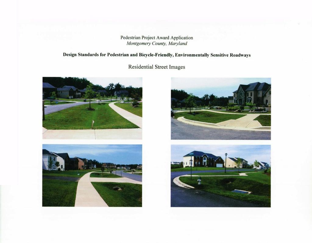
1 Pedestnan Project Award Application Montgomery County, Maryland May 28,2003 Design Standards for Pedestrian and Bicycle-Friendly, Environmentally Sensitive Roadways Proiect Obiectives and Results Montgomery County, Maryland has developed an innovative set of design standards for open section roadways with sidewalks and off-road bikepaths. These standards were prepared primarily for application in the environmentally sensitive watersheds throughout the County. Three design standards were prepared for low volume residential streets (Tertiary, Secondary, and Residential Primary classzfkations) and three design standards were prepared for Master Planned collector roadways (Master Planned Primary, 2-lane Arterial, and 4-lane Divided Arterial). Two landscaping design standards and a policy to allow waivers for closed section roads in environmentally sensitive watersheds were are also developed as part of this project. These standards are the product of an effort that balanced the competing goals and objectives of a diverse group of stakeholders. The acknowledged group of stakeholders included motorists, pedestrians, bicyclists, public agencies, the development community, private utility companies, and the future residents. Noteworthy features of these standards include:& locating the sidewalks and off-road bikepaths behind the side ditches -for maximum clear zones from potentially errant vehicles; improved water quality of runoff due to reduced impervious (roadway) surface area and the natural filtering action of the sodded shoulders and side ditches; maintaining consistent driveway (longitudinal grade) and sidewalk (cross) slopes to satisfy the Americans With Disabilities Act; uniform shoulder and ditch sections - dimensions and slopes determined based on the hierarchy of roadway classifications; preserving developmentaot yields through the use of Public Improvements Easements (in lieu of requiring additional right-of-way); and providing street tree species and locations to promote shading the pavement and grass surfaces, in locations relative to the roadway classifications, to reduce the temperature of stormwater runoff..' These design standards are the result of the efforts of a dedicated team of public professionals drawn from staff in the Maryland-National Capital Park & Planning Commission, the Montgomery County Department of Permitting Services, and this Department. The local development community, through their representatives in the Maryland National Capital Building Industry Association and the Montgomery County Road Code Committee also offered invaluable suggestions, prior to approval of these details. The underlying goals of this project have been achieved. As a result of the reduced runoff and improved water quality at the storm drain outfalls, the environmental impact of open section roadways is significantly less than that of a comparable classification closed section roadway. Pedestrians, bicyclists, and handicapped persons are provided a pleasant and safe environment. The shoulder and ditch side slopes are such that maintenance by the abutting homeowners and public works crews can be performed with relative ease. Plan approval and permit acquisition have been facilitated since the adoption of these standards. These standards have now gained the acceptance and support of the regulatory (planning, transportation, and environmental) agencies as well as the private development industry. These design standards are now available on the internet through the County's website:
2 Pedestrian Project Award Application Montgomery County, Maryland Design Standards for Pedestrian and Bicycle-Friendly, Environmentally Sensitive Roadways Analvsis of the Proiect s Historv, Challenges, and Solutions The ProblemNeed for the Promam In 1992, the Montgomery County Council adopted two pieces of legislation which were intended to result in the construction of more sidewalks in new residential, commercial, and industrial subdivisions. This legislation amended two sections of the Montgomery County Code: Chapter 49 (the Road Code ) and Chapter 50 ( Subdivision of Land ). Administration of these two Chapters today falls under the joint jurisdictions of the Montgomery County Planning Board, the County Department of Public Works & Transportation, and the Department of Permitting Services.. Bill No amended Chapter 49 to require the construction of sidewalks in new subdivisions. When it was originally introduced, the bill proposed the construction of sidewalks where the zoning resulted in minimum lot sizes of one acre or less. Since the County s design standards at the time allowed sidewalks only on roads constructed with curb and gutter, this proposal would have resulted in significant environmental impact. The proposals were subsequently reconsidered and modified. In the bill s adopted form, sidewalks are now required in residential developments where the subdivision zoning results in minimum lot sizes of 25,000 square feet or less. The bill generally precludes the construction of streets with curbs and gutters ( closed section streets) in environmentally sensitive watershed areas (as designated by the Maryland Department of the Environment) or any headwaters area (when designated as environmentally sensitive by the County Department of Environmental Protection)., Companion Ordinance No amended the Subdivision Ordinance to also require the construction of sidewalks in new residential, commercial, and industrial developments. This bill was intended to provide better connectivity between new and existing adjacent developments. The bill provides the Montgomery County Planning Board the authority to require developers to extend sidewalks a reasonable distance off-site to connect with another sidewalk or an (existing or proposed) bus stop or public facility. The bill also requires constructing sidewalks on new public streets and existing frontage roads. The need to construct sidewalks on public open section roadways (roads which use shoulders and side ditches to redirect stormwater runoff) created a dilemma for both the public and the private sectors: the then-adopted County roadway design standards did not include sidewalks on open section roads. As a result, there was no consistency in the locations where private consulting engineers proposed to construct the required sidewalks: some engmeers proposed locating the sidewalk in the shoulder area while others proposed it behind the side ditch. This situation necessitated site specific designs and delayed all construction plan approvals (even subdivision plans that were not directly. affected by this legislation, because they were remained in the review queue). The County had an obligation to develop new design standards to resolve that problem. 1
3 Pedestrian Project Award Application,\ Montgomery County, Maryland Description of the Proaam An all-volunteer team of public professionals was organized in early 1994, charged with the task of developing a set of recommended design standards. Six representatives (two from each of the three County agencies that were affected by the legislation) participated on the original team [agency representatives did change over time, as the project evolved from conceptual planning to design and implementation]. Each person was a specialist with either a transportation or an environmental background. Each team member had an equal vote in the team s discussions and was encouraged to consult with other staff in their agency. Because this team was composed entirely of volunteers, operating without a dedicated budget or schedule;.meetings were held on an infrequent basis - in large part to accommodate the team members official work assignments, priorities, and individual schedules. Team members were forced to think in an innovative manner, overcome their own individual biases and agendas, and cooperate with one another to achieve consensus. The team was also ubliged to balance the transportation and environmental criteria of the enabling legislation, as well as the oftencompeting goals of the previously identified group of stakeholders. Such considerations included: providing for safe passage by motorists, pedestrians, and bicyclists - commensurate with the roadway s classification and function; providing pedestrian facilities in accordance with the Americans With Disabilities Act (ADA); decreasing the volume of stormwater runoff by minimizing paved surface area; decreasing the temperature of stormwater runoff by shading paved surfaces and side ditches; maximizing the use of grass surfaces to naturally filter stormwater runoff of sediment, road salts, heavy metals, and organic materials and encouraging groundwater recharge; facilitating the design and approval of plans for roads, sidewalks, off-road bikepaths, and driveways; ensuring manageable construction costs for permittees and the County; preserving potential development yields through the use of Public Improvements Easements (for public facilities located outside the public rights-of-way); providing facilities which do not exacerbate public and/or private construction and maintenance costs; providing an aesthetically pleasing and readily-maintainable neighborhood for the future residents; and facilitating access to the private/public utility companies underground facilities. The team developed six typical sections based on the hierarchy of roadway classifications found in the County Road Code: tertiary, secondary, primary, and arterial. These typical sections were divided into two distinct groups: residential streets and master planned roads. The three residential street standards are for tertiary, secondary, and residential primary roadways. The three masterplanned roads standards are for the master planned primary and two arterial roadways. Residential streets are envisioned to be low volume, low speed roads on which their neighborhood character has been a significant consideration. These roadway classifications are determined during the subdivision review process. Enhancing the neighborhood character - by shading the street - is an important goal of the residential roadway sections. 2
4 Pedestrian Project Award Application Montgornely County, Maryland Description of the Program (cont.) Masterplanned roadways, on the other hand, are determined through the County s Master Plan process. These roads are expected to carry greater volumes of traffic - often at higher speeds - with little or no direct driveway access. As such, they are intended to facilitate the through movement of vehicular traffic. They are also those roadways on which bicycle facilities are most often located. For those reasons, the team chose to emphasize vehicular and bicyclist safety on the master planned road sections. The team was challenged by five major issues. Those issues were: A. widths of rights-of-way versus perpetual easements; B. location and species of street trees; C. location, width, and material of the sidewalk and bikepaths; and D. identification of the optimum dimensions and slopes of the shoulder, ditch, and driveway; and E. criteria to allow closed section streets in environmentally sensitive watersheds on nzn-ow frontage lots. A. Widths of rights-of-wav versus perpetual easements: The County s standard rights-of-way are not sufficient to accommodate all of the required improvements. As a result, the team evaluated the desirability of wider right-of-way widths versus the use of perpetual easements. Wider rights-of-way were not favored for several reasons: greater out-to-out setbacks between opposing houses, potential additional encroachment on any environmentally sensitive areas behind the proposed homes, and reduced development yields. Consequently, the team advocated the use of Public Improvements Easements (PIES) to allow sidewalks and off-road bikepaths to be constructed and publicly maintained on private property. Public Utility Easements are also proposed to overlap the PIES as necessary to provide the utility companies ten (10) feet of unencumbered work area. B. Location and species of street trees: Street tree locations are a critical component of these typical sections. Heretofore, the County s standards reflected street tree locations (on open section roads) only behind the side ditch, The team wanted to promote the environmental benefit which will result from shading the pavement and grass areas while still providing a reasonable balance between environmental sensitivity, safety, and aesthetics. County arborists aided the team by recommending a list of deciduous tree species based on their root growth and branching characteristics. To reinforce the concept of a hierarchy of roadway classifications, the location of street trees varies within the different sections. On the residential streets, street trees are proposed to be planted in front of or within the side ditch - to maximize the shading benefit and enhance the neighborhood character. The separation between the edge of the roadway and the street tree differs relative to, the hierarchy of roadway classifications. On the master planned roadways, where safety is promoted by providing a clear (horizontal) zone from vehicles, street trees are proposed behind the side ditch in accordance with the previously adopted standards. Since these three standards allow street trees to be planted within three (3) feet of the sidewalk and the off-road bikepath, root barriers are to be provided to protect those paved surfaces fiom damage by the nearby trees. 3
5 Pedestrian Project Award Application Montgomery County, Maryland Description of the Promam (cont.) C. D. E. Location, width, and material of the sidewalk and bikepaths: Each of the approved standards locates the sidewalk behind the side ditch. This location was determined to be the optimal location for several reasons including safety, constructability, aesthetics, and maintenance. A four (4)-fOOt wide sidewalk was approved for the tertiary and secondary streets while a five (5) foot wide sidewalk was approved on the primary and arterial roadways. An eight (8) foot wide off-road bikepath is shown behind the side ditch on the primary and arterial standards. On the two arterial roadway sections, the roadway shoulder is paved only four (4) feet wide [instead of our current standard of eight (8) feet] to minimize impervious surface area; this area is available for use by on-street bicyclists.._ The originally approved standards reflected the use of bituminous concrete dnveways, sidewalks, and bikepaths. However, to facilitate the long-term maintenance of the sidewalks, the material was amended to portland cement concrete on the July 1 1,2000 standards. At the request of the development community, it was agreed that the driveway apron may be constructed using concrete or asphalt, at the discretion of the developer. Identification of the optimum dimensions and slopes of the shoulder, ditch, and driveway: In order to maintain adequate cover over the dnveway culverts and satisfy the ADA-mandated two (2) percent cross-slope across the sidewalk, a number of alternatives were analyzed. In the end, it was decided to employ a single uniform cross-section for each standard. These uniform crosssections, which will facilitate plan approvals as well as future roadway and driveway construction, neces-sitated modifications to the County s typical dimensions and slopes on the shoulder and side ditch. Roadway classification and function were considered in determining the extent of these adjustments. Criteria to allow closed section streets in environmentallv sensitive watersheds on narrow frontage lots: During the development of these standards, the development community advised the team that open section residential streets would be undesirable on streets bordered by narrow frontage lots. It was agreed that criteria needed to be developed to allow the automatic approval of closed section roads along such lots, without the requirement of a formal waiver request. The team s recommen-dations have been approved. In general, streets with lots averaging eighty (80) feet or less may auto-matically be designed as closed section roads, with the construction of additional water quality measures. Lots averaging one hundred (100) feet or more should be designed as open section roads. Streets with average lot frontages in the eighty (80) to one hundred (100) foot range require a site specific justification and approval. Conclusions The underlying goals of this project have been achieved. As a result of the reduced runoff and improved water quality at the storm drain outfalls, the environmental impact of open section roadways is significantly less than that of a comparable classification closed section roadway. Pedestrians, bicyclists, and handicapped persons are provided a pleasant and safe environment. The shoulder and ditch side slopes are such that maintenance by the abutting homeowners and public works crews can be performed with relative ease. Plan approval and permit acquisition have been facilitated since the adoption of these standards. These standards have now gained the acceptance and support of the regulatory (planning, transportation, and environmental) agencies as well as the private development industry. These design standards are now available on the internet through the County s website: 4
6 TYPICAL ROAD SECTION '4. CONCRETE 6' AT DRNEWAYS._ PAVING SECTION 3" BITUMINOUS CONCRETE BASE COURSE 1 APPROVED SUBGRADE I GENERAL NOTES REFER TO MARYLAND 'STATE HIGHWAY ADMINISTRATION SPECIFICATIONS FOR MATERIALS AND ME~HODS OF CONSTRUCTION. SEE STANDARD NO. MC METHODS OF GRADING SIDE SLOPES. PUBLIC UTlLlM EASEMENTS (PUEs) ARE SUBJECT TO THE TERMS AND CONDITIONS OF A DOCUMENT ENTITLED "DECLARATIONS OF TERMS AND PROVISIONS OF PUBLIC UTlLlM EASEMENTS" THAT IS RECORDED IN THE LAND RECORDS OF MONTGOMERY COUNTY IN LIBER 3834 AT FOLIO 457. THE SIDE DITCH IN FILL SLOPES MAY BE ELIMINATED IN AREAS NOT MASTER PLANNED FOR DEVELOPMENT ONLY AFTER OVERLAND FLOW PATH AND EROSION POTENTIAL ARE CONSIDERED. SEE STANDARDS NO. MC AND MC FOR SPECIES, SIZE AND SPACING OF STREET TREES. WHEN USING THIS STANDARD, THE GARAGE SHALL BE SET BACK A MINIMUM DISTANCE OF 20 FEET, MEASURED FROM THE BACK EDGE OF THE SIDEWALK. THE MINIMUM BUILDING RESTRICTION LINE SETBACK IS 25 FEET. STREET LIGHTING POLES ARE TO BE LOCATED AS DIRECTED BY THE MONTGOMERY COUNTY DEPARTMENT OF PUBLIC WORKS AND TRANSPORTATION. PUBLIC IMPROVEMENTS EASEMENTS (PIES) ARE TO BE GRANTED BY A SITE SPECIFIC DECLARATION OF PUBLIC IMPROVEMENTS EASEMENT DOCUMENT. THAT DOCUMENT IS TO BE RECORDED IN THE LAND RECORDS OF MONTGOMERY COUNTY, MARYLAND AND REFERENCED ON THE RECORD PLAT. THE 2-FOOT WIDE SECTION OF THE PIES BEHIND THE SIDEWALKS IS TO ALLOW FOR THE TEMPORARY CONSTRUCTION, RECONSTRUCTION, AND MAINTENANCE OF THE SIDEWALKS. NO PERMANENT PUBLIC IMPROVEMENTS ARE TO BE PLACED WITHIN THESE 2-FOOT WIDE STRIPS. SEVERAL OF THE DIMENSIONS SPECIFIED ON THIS STANDARD REFLECT MODIFICATIONS TO THE VALUES SHOWN ON STANDARD NO. MC (RESIDENTIAL DRIVEWAY/OPEN SECTION ROAD). ELEVATION AT THE FRONT EDGE OF SIDEWALK = EDGE OF PAVEMENT ELEVATION ' APPROVED STANDARD NO. MC

7 TYPICAL ROAD SECTION 4'-0' SHOULDER 'w Li 2 $1._ 1/2' BITUMiNi BITUMINOUS cconcrete o i n SURFACE BASE COURSE ioutm. 6' AT DRIVEWAYS CLASS I BIKEPATH (SEE NOTE 14) STD. Mc ~ TYPE A PAVING SECTIONS?!I 4" CONCRETE 6' AT DRIVEWAYS, I 3" BITUMINOUS CONCRETE SURFACE COURSE IN 2-1 1/2" LAYERS 5." BITUMINOUS CONCRETE BASE 8" GRADED AGGREGATE BASE I 9" BITUMINOUS CONCRETE BASE COURSE IN 2-4 1/2" LAYERS SUBGRADE DRAINS REQUIRED SEE MC PREFERRED GENERAL I APPROVED SUBGRADE 1 NOTES ALTERNATE REFER TO MARYLAND STATE HIGHWAY ADMINISTRATION SPECIFICATIONS FOR MATERIALS AND METHODS OF CONSTRUCTION. SEE STANDARD NO. MC METHODS OF GRADING SIDE SLOPES. PUBLIC unm EASEMENTS (PUE~) ARE SUBJECT TO THE TERMS AND CONDITIONS OF A DOCUMENT ENTITLED "DECLARATIONS OF TERMS AND PROVISIONS OF PUBLIC UTILITY EASEMENTS" THAT IS RECORDED IN THE LAND RECORDS OF MONTGOMERY COUNTY IN UBER 3834 AT FOLIO 457. THE SIDE DITCH IN FILL SLOPES MAY BE ELIMINATED IN AREAS NOT MASTER PLANNED FOR DEVELOPMENT ONLY AFER OVERLAND FLOW PAM AND EROSION POTENTIAL ARE CONSIDERED. A PHYSICAL ROOT BARRIER SHALL BE PROVIDED WHERE STREET TREES ARE CLOSER THAN SIX FEET TO A SIDEWALK OR BIKEPATH. MINIMUM DEPTH OF ROOT BARRIER SHALL BE EIGHTEEN INCHES. ROOT BARRIER SHALL EXTEND A MINIMUM DISTANCE OF 10 FEET LONGITUDINALLY ON EITHER SIDE OF THE TREE. SEE'STANDARDS NO. MC AND MC FOR SPECIES, SIZE AND SPACING OF STREET TREES. WHEN USING THIS STANDARD, THE GARAGE SHALL BE SET BACK A MINIMUM DISTANCE OF 20 FEET, MEASURED FROM THE BACK EDGE OF THE SIDEWALK (OR BIKEPATH, AS APPROPRIATE). STREET LIGHTING POLES ARE TO BE LOCATED AS DIRECTED BY THE MONTGOMERY COUNTY DEPARTMENT OF PUBLIC WORKS AND TRANSPORTATION. PUBLIC IMPROVEMENTS EASEMENTS (PIES) ARE TO BE GRANTED BY A SITE SPECIFIC DECLARATION OF PUBLIC IMPROVEMENTS EASEMENT DOCUMENT. MAT DOCUMENT IS TO BE RECORDED IN THE LAND RECORDS OF MONTGOMERY COUNM. MARYLAND AND REFERENCED ON THE RECORD PLAT. THE 2-FOOT WIDE SECTIONS OF THE PIES BEHIND THE SIDEWALK/BIKEPATH ARE TO ALLOW FOR THE CONSTRUCTION, RECONSTRUCTION, AND MAINTENANCE OF THE SIDEWALKS AND BIKEPATH (AND THE INSTALLATION OF STREETLIGHTING BEHIND THE SIDEWALK AND/OR THE BIKEPATH, IF REQUIRED BY THE DIVISION TRAFFIC AND PARKING SERVICES). SEVERAL OF THE DIMENSIONS SPECIFIED ON THIS STANDARD REFLECT MODIFICATIONS TO THE VALUES SHOWN ON STANDARD NO. MC (RESIDENTIAL DRIVEWAY/OPEN SECTION ROAD). DRIVEWAY WILL BE CONSIDERED ON A CASE BY CASE BASIS BUT ARE NOT TO BE ENCOURAGED ON ARTERIAL ROADWAYS. DRIVEWAY PIPES LARGER THAN 15" x 21" MAY NOT BE USED WITH THIS STANDARD. ELEVATION AT THE FRONT EDGE OF SIDEWALK/BIKEPATH - OUTSIDE EDGE OF PAVED SHOULDER ELEVATION ' BIKEPATH WILL BE REOUIRED ONLY IF SPECIFIED IN THE MASTER PLAN OR IF INCLUDED AS A CONDITION OF SUEDNlSlQN APPROVAL. '. REVISED MONTGOMERY COUNTY DEPARTMENT DIRECTOR, U6Wr -- \ + U ARTERIAL DUAL ROAD OPEN SECTION WITH SIDEWALK H BIKEPATH. AND STREET TREES I I I=I STANDARD NO. MC
8
9
CONFORMED AGREEMENT INCORPORATED REVISIONS PER AMENDMENT DATED: APRIL 2, 2013 FOR REFERENCE
 CONFORMED AGREEMENT INCORPORATED REVISIONS PER AMENDMENT DATED: APRIL 2, 2013 FOR REFERENCE CITY STREETS AS PART OF STATE HIGHWAYS GUIDELINES REACHED BY THE WASHINGTON STATE DEPARTMENT OF TRANSPORTATION
TOP TEN LIST OF COMMUNITY CONCERNS REGARDING PROPOSED AMENDMENTS TO CHAPTER 42
 TOP TEN LIST OF COMMUNITY CONCERNS REGARDING PROPOSED AMENDMENTS TO CHAPTER 42 1. Extend the urban area to Beltway 8 in stages, over say a three-year period, prioritizing development in transit and declining
F. Driveways. Driveways which provide access to off-street parking or loading from public streets shall comply with the following:
 Section 20.945.040 General Design Standards for Surface Parking Areas. A. Review Authority. Parking lot design and drainage shall be subject to review and approval of the City Transportation Manager. B.
STORMWATER MANAGEMENT CODES ANALYSIS RICHLAND COUNTY, SC SITE PLANNING ROUNDTABLE
 STORMWATER MANAGEMENT CODES ANALYSIS RICHLAND COUNTY, SC SITE PLANNING ROUNDTABLE Codes analyses for each subcommittee were completed to assist participants of the Richland County Site Planning Roundtable.
Title 11 Streets and Sidewalks
 Chapter 11.01 - Definitions Title 11 Streets and Sidewalks Low Impact Development (LID) - A stormwater and land use management strategy that strives to mimic predisturbance hydrologic processes of infiltration,
When planning stormwater management facilities, the following principles shall be applied where possible.
 2.0 Principles When planning stormwater management facilities, the following principles shall be applied where possible. 2.0.1 Drainage is a regional phenomenon that does not respect the boundaries between
PLANNED UNIT DEVELOPMENT STAFF REPORT Date: June 2, 2016
 # 9 ZON2016-01032 PLANNED UNIT DEVELOPMENT STAFF REPORT Date: June 2, 2016 DEVELOPMENT NAME JJT Properties LLC LOCATION 1147 & 1151 East I-65 Service Road South and 1180 Sledge Drive (Southeast corner
COMMUNITY DESIGN. GOAL: Create livable and attractive communities. Intent
 COMMUNITY DESIGN Intent An attractive, well-designed County will attract quality development, instill civic pride, improve the visual character of the community, and create a strong, positive image for
The Town Board of the Town of Vienna, County of Dane, State of Wisconsin, does ordain and adopt as follows.
 ORDINANCE DRIVEWAYS AND CULVERTS NO. 6-5-06 ORDINANCE CONCERNING DRIVEWAY AND CULVERT REQUIREMENTS 1-1-1 Driveway Permits; Culvert Requirements 1-1-2 Driveway and Culvert Location, Design and Construction
CARVER COUNTY DIVISION OF PUBLIC WORKS LANDSCAPE POLICY. Adopted by the Carver County Board of Commissioners March 3, 2015
 CARVER COUNTY DIVISION OF PUBLIC WORKS LANDSCAPE POLICY Adopted by the Carver County Board of Commissioners March 3, 2015 Policy Statement Goals It is the goal of Carver County Public Works to provide
VALLEY COUNTY MINIMUM STANDARDS FOR PRIVATE ROAD DESIGN AND CONSTRUCTION
 MINIMUM STANDARDS FOR PRIVATE ROAD DESIGN AND CONSTRUCTION Adopted November 28, 2005 TABLE OF CONTENTS DEFINITION OF TERMS...II I. DESIGN CRITERIA... 1 A. GENERAL DESIGN CRITERIA... 1 B. ROADWAY CLASSIFICATION...
The Illinois Department of Transportation and Lake County Division of Transportation. Route 173, including the Millburn Bypass
 The Illinois Department of Transportation and Lake County Division of Transportation welcome you to this Public Hearing for U.S. Route 45 from Illinois Route 132 to Illinois Route 173, including the Millburn
ARTICLE 6: Special and Planned Development Districts
 ARTICLE 6: Special and Planned Development Districts 6-10 Traditional Neighborhood Development (TND) District 6-10.10 Purpose and Intent The Traditional Neighborhood Development (TND) District provides
ARTICLE 13 STREETS General
 ARTICLE 13 STREETS 13.1 General Streets shall be designed to suit their functions. Many streets have purposes other than vehicular traffic. As an alternative to current N.C. Department of Transportation
Low Density Projects. Design Objective
 E-1. Low Density Projects Design Objective Low density projects are not required to be equipped with Stormwater Control Measures (SCMs) in exchange for limiting their built-upon area, maximizing dispersed
COMPLETE GREEN STREET CHECKLIST
 COMPLETE GREEN STREET CHECKLIST This document was developed to dissect the structure of an urban street and explore opportunities to make our streets more complete while also integrating green street strategies.
5.4 Development Incentives for All Commercial and Industrial Districts (except the TC: Town Center District).
.") 5.4 Development Incentives for All Commercial and Industrial Districts (except the TC: Town Center District). The following Development Incentives are provided in order to encourage flexibility and creativity
5.4 Development Incentives for All Commercial and Industrial Districts (except the TC: Town Center District). The following Development Incentives are provided in order to encourage flexibility and creativity
5. LOW IMPACT DEVELOPMENT DESIGN STANDARDS
 5. LOW IMPACT DEVELOPMENT DESIGN STANDARDS Low Impact Development (LID) requires a shift in stormwater management away from conveying runoff to a small number of downstream points through hydraulically
ARTICLE 13 STREETS General
 ARTICLE 13 STREETS 13.1 General Streets shall be designed to suit their functions. Many streets have purposes other than vehicular traffic. As an alternative to current N.C. Department of Transportation
A BILL FOR AN ORDINANCE TO AMEND CHAPTER 9, KAUAI COUNTY CODE 1987, RELATING TO STREET REQUIRE:MENTS FOR SUBDIVISIONS
 ORDINANCE NO. BILL NO. { vy"yj1j A BILL FOR AN ORDINANCE TO AMEND CHAPTER 9, KAUAI COUNTY CODE 1987, RELATING TO STREET REQUIRE:MENTS FOR SUBDIVISIONS BE IT ORDAINED BY THE COUNCIL OF THE COUNTY OF KAUA'I,
ORDINANCE NO WHEREAS, the City provided the proposed code amendments to the Washington State Department of Commerce on September 20, 2017; and
 ORDINANCE NO. 1541 AN ORDINANCE OF THE CITY OF LYNDEN AMENDING THE CITY'S MUNICIPAL CODE TITLE 12 STORMWATER MANAGEMENT SYSTEM, TO INCORPORATE AND REQUIRE LOW IMPACT DEVELOPMENT (LID) PRINCIPLES AND BEST
Urban Design Manual 2.0 DRIVE-THROUGH FACILITIES. Background. Urban Design Challenges
 222221 2.0 DRIVE-THROUGH FACILITIES Background In recent years, drive-through facilities have grown significantly in popularity with drive-through restaurants, in particular, being established on numerous
KASPER. City of Georgetown, Texas PUD Planned Unit Development. December 30, 2015 Revised January 27, 2016
 KASPER City of Georgetown, Texas PUD Planned Unit Development December 30, 2015 Revised January 27, 2016 Applicant: Sentinel Land Company, LLC 4910 Campus Drive Newport Beach, CA Prepared by: SEC Planning
Improve the appearance of off-street parking areas, vehicular use areas, and property abutting public and private roads;
 Bedford Township, MI (Monroe Co.) 2012 http://library.municode.com/index.aspx?clientid=02123 400.1907 - Landscaping and screening. Se 1907. 1. Intent. Landscaping, greenbelts, and screening are necessary
MONTGOMERY COUNTY PLANNING DEPARTMENT THE MARYLAND-NATIONAL CAPITAL PARK AND PLANNING COMMISSION
 MONTGOMERY COUNTY PLANNING DEPARTMENT THE MARYLAND-NATIONAL CAPITAL PARK AND PLANNING COMMISSION MCPB Item No. Date: 12-10-15 Leisure World Clubhouse II Addition Fitness Center, Limited Site Plan Amendment
STORMWATER - GENERAL NOTES
 STORM DRAINAGE CONSTRUCTION NOTES. All storm sewer pipe shall be reinforced concrete. 2. Storm drainage pipes shall be a minimum of fifteen (5) inch diameter (5" for short lateral runs only - up to 75
3. Additional driveways may be permitted where determined by the Planning Commission to adequately accommodate traffic or ensure public safety.
 ARTICLE 10 ACCESS MANAGEMENT Section 10.01 Purpose. The purpose of this Article is to protect the substantial public investment in the City s street system by preserving the traffic capacity of existing
ARLINGTON COUNTY, VIRGINIA. County Board Agenda Item Meeting of February 23, 2019
 ARLINGTON COUNTY, VIRGINIA County Board Agenda Item Meeting of February 23, 2019 DATE: February 15, 2019 SUBJECT: Amendment to the Master Transportation Plan (MTP) Map to add a new section of North Kansas
CHAPTER 26 LANDSCAPING (Chapter added in its entirety 05-08)
") CHAPTER 26 LANDSCAPING (Chapter added in its entirety 05-08) 26.01 DESCRIPTION AND PURPOSE. Landscaping is an important element of the use, development and preservation of land, and a significant factor
CHAPTER 26 LANDSCAPING (Chapter added in its entirety 05-08) 26.01 DESCRIPTION AND PURPOSE. Landscaping is an important element of the use, development and preservation of land, and a significant factor
Your town s subdivision or land use ordinance standards should reference the following street standards, for example:
 Your town s subdivision or land use ordinance standards should reference the following street standards, for example: Streets shall be designed to move traffic safely and in a way that minimizes environmental
PARKLET PROPOSAL PACKAGE & PROCESS
 500.3 I PARKLETS The term parklet refers to a small temporary constructed seating or community gathering area over an on-street parking space or an extension of the sidewalk into the operating State highway
R E S O L U T I O N. Single-Family Residence/ Church. 2,488 sq. ft. 2,488 sq. ft. Area Parking Required: Church
 R E S O L U T I O N WHEREAS, the Prince George s County Planning Board is charged with the approval of Detailed Site Plans pursuant to Part 3, Division 9 of the Zoning Ordinance of the Prince George s
MIXED-USE ZONING DISTRICT DESIGN GUIDELINES
 MIXED-USE ZONING DISTRICT DESIGN GUIDELINES In addition to the development regulations contained in the Mixed-Use Zoning District, design guidelines are presented here to provide an added level of definition
5.1 Commercial and Industrial Development. (Effective April 1, 2006)
") 5.1 Commercial and Industrial Development. (Effective April 1, 2006) A. Applicability: The requirements of this section (5.10) shall apply to all uses within the LB Local Business; HB Highway Business;
5.1 Commercial and Industrial Development. (Effective April 1, 2006) A. Applicability: The requirements of this section (5.10) shall apply to all uses within the LB Local Business; HB Highway Business;
Glenn Highway MP DSR. Landscape Narrative
 Glenn Highway MP 34-42 DSR Landscape Narrative Project Landscape Goals The Glenn Highway MP 34-42 Project extends through a variety of landscape types typical to the Matanuska-Susitna Valley. In general,
5.1.1 The streetscape along US Highway 64 (Brevard Road); and, The built environment within new residential developments; and,
; and, The built environment within new residential developments; and,") Article 5. Landscaping 5.1 Purpose The Town of Laurel Park s landscape standards are designed to create a beautiful, aesthetically pleasing built environment that will complement and enhance community
Article 5. Landscaping 5.1 Purpose The Town of Laurel Park s landscape standards are designed to create a beautiful, aesthetically pleasing built environment that will complement and enhance community
3. VISION AND GOALS. Vision Statement. Goals, Objectives and Policies
 Vision Statement Queen Creek s interconnected network of parks, trails, open spaces and recreation opportunities provide safe and diverse activities and programs that sustain its unique, small town, equestrian
City of Richmond. Engineering Design Specifications
 City of Richmond Design Specifications June 2008 CITY OF RICHMOND ENGINEERING DESIGN SPECIFICATIONS JUNE 2008 THIS DOCUMENT DETAILS THE MINIMUM STANDARDS TO BE USED FOR THE DESIGN OF ENGINEERING PROJECTS
ARTICLE 3 LANDSCAPING AND SCREENING REQUIREMENTS
 ARTICLE 3 CHAPTER 4 LANDSCAPING AND SCREENING REQUIREMENTS SEC 3.401 SEC 3.402 (D) (E) PURPOSE: The purpose of this Chapter is to establish minimum standards for the design, installation, and maintenance
CITY PLANNING COMMISSION AGENDA. ITEM NO(s): C.1 C.3 STAFF: STEVE TUCK
: C.1 C.3 STAFF: STEVE TUCK") Page 34 CITY PLANNING COMMISSION AGENDA ITEM NO(s): C.1 C.3 STAFF: STEVE TUCK FILE NOS: CPC ZC 12-00035 QUASI-JUDICIAL CPC NV 12-00036 QUASI-JUDICIAL AR DP 12-00039 QUASI-JUDICIAL PROJECT: APPLICANT: OWNER:
Page 34 CITY PLANNING COMMISSION AGENDA ITEM NO(s): C.1 C.3 STAFF: STEVE TUCK FILE NOS: CPC ZC 12-00035 QUASI-JUDICIAL CPC NV 12-00036 QUASI-JUDICIAL AR DP 12-00039 QUASI-JUDICIAL PROJECT: APPLICANT: OWNER:
Olde Towne Vision Plan
 Olde Towne Vision Plan Introduction In 2016, the City of Bellevue will complete its move of City offices from Olde Towne Bellevue to its new municipal complex on Wall Street. The City intends to sell its
Chapter PEDESTRIAN COMMERCIAL (PC) ZONING DISTRICT
 ZONING DISTRICT") Chapter 11-17 PEDESTRIAN COMMERCIAL (PC) ZONING DISTRICT Sections: 11-17-01 GENERAL PURPOSE 11-17-02 PERMITTED BUILDING TYPES 11-17-03 USES PERMITTED WITH DESIGN REVIEW 11-17-04 USES PERMITTED BY CONDITIONAL
Chapter 11-17 PEDESTRIAN COMMERCIAL (PC) ZONING DISTRICT Sections: 11-17-01 GENERAL PURPOSE 11-17-02 PERMITTED BUILDING TYPES 11-17-03 USES PERMITTED WITH DESIGN REVIEW 11-17-04 USES PERMITTED BY CONDITIONAL
City of Waco Stormwater Management Regulations
 1.0 Applicability: City of Waco Stormwater Management Regulations These regulations apply to all development within the limits of the City of Waco as well as to any subdivisions within the extra territorial
CITY PLANNING COMMISSION AGENDA ITEM: C STAFF: ROBERT TEGLER FILE NO: CPC PUD QUASI-JUDICIAL
 CPC AGENDA June 8, 2006 Page 37 CITY PLANNING COMMISSION AGENDA ITEM: C STAFF: ROBERT TEGLER FILE NO: CPC PUD 05-294 - QUASI-JUDICIAL PROJECT: APPLICANT: OWNER: PARKWOOD AT WOLF RANCH NASS DESIGN ASSOCIATES
City of Petersburg, VA Stormwater Utility Frequently Asked Questions
 Q. What is stormwater runoff? A. Stormwater runoff is the water that flows off roofs, driveways, parking lots, streets and other hard surfaces during rain storms. Stormwater runoff is also the rain that
Camden County Development Regulations. Updated February 2017
 Camden County Development Regulations Updated February 2017 GENERAL MEETING SCHEDULE OF THE CAMDEN COUNTY PLANNING BOARD All meetings will convene at 6:00 PM on the 4th Tuesday of each month and will be
CITY OF KITCHENER CONDITIONS REQUIRED FOR ISSUANCE OF SITE PLAN APPROVAL
 CITY OF KITCHENER CONDITIONS REQUIRED FOR ISSUANCE OF SITE PLAN APPROVAL The following is a list of conditions requiring completion to the City s Satisfaction prior to Site Plan Approval being granted
SDOT DPD. SDOT Director s Rule DPD Director s Rule DCLU DR SED DR of 7 CITY OF SEATTLE
 SDOT SDOT Director s Rule 2-07 DPD Applicant: CITY OF SEATTLE Page 1 of 7 Supersedes: DCLU DR 11-93 SED DR 93-4 Seattle Department of Transportation (SDOT) Department of Planning and Development (DPD)
Neo-Traditional Overlay Application
 MAYOR AND CITY COUNCIL OF LAUREL DEPARTMENT OF ECONOMIC AND COMMUNITY DEVELOPMENT 8103 Sandy Spring Road Laurel, Maryland 20707 (301) 725-5300 Internet Address http://www.cityoflaurel.org E-mail: ecd@laurel.md.us
Section 9 NEIGHBORHOOD DESIGN
 Section 9 NEIGHBORHOOD DESIGN City of Lancaster Comprehensive Plan D u n k i n, S e f k o & A s s o c i a t e s, I n c. NEIGHBORHOOD DESIGN INTRODUCTION There are many ways in which a neighborhood can
LOUISIANA STATE UNIVERSITY COMPREHENSIVE & STRATEGIC CAMPUS MASTER PLAN. APPENDIX G - Stormwater Study Findings & Stormwater Solutions
 LOUISIANA STATE UNIVERSITY COMPREHENSIVE & STRATEGIC CAMPUS MASTER PLAN APPENDIX G - Stormwater Study Findings & Stormwater Solutions LSU: MP Narrative July 2017 3.5 Open Space Existing Conditions The
PRELIMINARY PLAT DESIGN REQUIREMENTS Updated 4/8/2016
 PRELIMINARY PLAT DESIGN REQUIREMENTS Updated 4/8/2016 The following items are required for the preliminary plat. Numbers correspond with those on the example preliminary plat. RENO COUNTY SUBDIVISION REQUIREMENTS
BUFFERS, TREE PROTECTION AND LANDSCAPING. Sec Purpose and Intent.
 ARTICLE 20 BUFFERS, TREE PROTECTION AND LANDSCAPING Sec. 20.1. Purpose and Intent. Trees improve air and water quality, reduce soil erosion, reduce noise and glare, provide habitat for desirable wildlife,
City of Yelm. Tahoma Terra Final Master Plan Development Guidelines. Table of Contents
 City of Yelm Tahoma Terra Final Master Plan Development Guidelines Table of Contents Table of Contents... 1 Purpose... 2 Low Density Residential (R4-6)... 3 Moderate Density Residential (R6-10)... 5 Neighborhood
STORM DRAINAGE CONSTRUCTION NOTES LENGTH RUN * See Note 2., Above or greater 500
 STORM DRAINAGE CONSTRUCTION NOTES 1. ALL STORM SEWER PIPE SHALL BE REINFORCED CONCRETE UNLESS APPROVED BY THE CITY ENGINEER. 2. STORM DRAINAGE PIPES SHALL BE A MINIMUM OF FIFTEEN (15) INCH DIAMETER (15"
The transportation system in a community is an
 7 TRANSPORTATION The transportation system in a community is an important factor contributing to the quality of life of the residents. Without a sound transportation system to bring both goods and patrons
CHESAPEAKE LANDSCAPE ORDINANCE
 CHESAPEAKE LANDSCAPE ORDINANCE CONSERVATION PRESERVATION CZO 19-600 Effective October 16, 2008 BUFFER YARD C PARKING LOT REFORESTATION YEAR 1 REFORESTATION YEAR 4 BUFFER YARD F CBPA REFORESTATION Page
LANDSCAPE ORDINANCE PASADENA PLANNING DEPARTMENT (713) FAX (713)
 FAX (713)") LANDSCAPE ORDINANCE PASADENA PLANNING DEPARTMENT (713) 475-5543 FAX (713) 477-1072 ARTICLE X. LANDSCAPING OF NONRESIDENTIAL SITES* Sec. 9-195. Applicability. (a) This article shall apply to the following:
LANDSCAPE ORDINANCE PASADENA PLANNING DEPARTMENT (713) 475-5543 FAX (713) 477-1072 ARTICLE X. LANDSCAPING OF NONRESIDENTIAL SITES* Sec. 9-195. Applicability. (a) This article shall apply to the following:
Section 11 Grading and Drainage Standards
 Section 11 Grading and Drainage Standards 11.1 INTRODUCTION The proper grading, conveyance, storage and release of storm water is critical to maintain the integrity of the Property. Drainage facilities,
Red Fox Commercial Outline Plan
 Red Fox Commercial Outline Plan City of Cold Lake, Alberta Prepared by Durrance Projects Ltd and Ross W. Sharp & Associates Ltd October 2014 Rupert 1 Table of Contents 1. PURPOSE...3 1.1. Location...4
MONTGOMERY COUNTY PLANNING DEPARTMENT THE MARYLAND-NATIONAL CAPITAL PARK AND PLANNING COMMISSION
 MONTGOMERY COUNTY PLANNING DEPARTMENT THE MARYLAND-NATIONAL CAPITAL PARK AND PLANNING COMMISSION MCPB Item No. Date: 3.10.2016 Site Plan 820160040 Nora School Parker Smith, Planning Technician, Area 1,
The following specific definitions shall apply to the landscaping and screening regulations contained in this article:
 ARTICLE XII. LANDSCAPING Sec. 5-421. Purpose. The purpose of landscaping and screening requirements is to improve certain setback and yard areas, including off-street vehicular parking and open-lot sales
Asbury Chapel Subdivision Sketch Plan
 Asbury Chapel Subdivision Sketch Plan PART 1: PROJECT SUMMARY Applicant: NVR Inc. Project Size: +/- 76.13 acres Parcel Numbers: 02101112,02116101,02116112, 02116113 Current Zoning: Transitional Residential
Chapter 19.5 LANDSCAPING REQUIREMENTS
 Chapter 19.5 LANDSCAPING REQUIREMENTS Sec. 19.5-1. Intent The intent of the landscaping requirements stated herein are as follows: To aid in stabilizing the environment's ecological balance by contribution
Design Guidelines for Residential Subdivisions
 Design Guidelines for Residential Subdivisions Development Services 972-466-3225 cityofcarrollton.com This page intentionally left blank. Table of Contents Purpose... 1 Design Objectives... 1 Design Guidelines
ARTICLE 21A LANDSCAPING AND SCREENING
 ARTICLE 21A LANDSCAPING AND SCREENING SECTION 21A.01 INTENT AND SCOPE OF REQUIREMENTS Landscaping, greenbelts, and screening are necessary for the continued protection and enhancement of all land uses.
ZONING AMENDMENT & PLANNED UNIT DEVELOPMENT STAFF REPORT Date: April 4, 2013
 ZONING AMENDMENT & PLANNED UNIT DEVELOPMENT STAFF REPORT Date: April 4, 2013 NAME DEVELOPMENT NAME LOCATION DIP Exchange, LLC DIP Exchange, LLC 93 Sidney Phillips Drive (West side of Sidney Phillips Drive,
DCA , Stormwater Quality and Facilities Ordinance June 23, 2009
 PROPOSED NEW SECTION 10.486 Stormwater Quality and Detention Facilities, Public Streets. A. Purpose. It is the City s policy to maintain the natural hydrology and preserve water quality by mitigating the
CHAPTER 3. Design Standards for Business, Commercial, Industrial, Recreational and Institutional Uses
 CHAPTER 3 Design Standards for Business, Commercial, Section Number Title Ordinance Number Date of Ordinance 16-3-1 Applicability 2006-11 2008-04 07-01-08 16-3-2 Uniform Standards for Architectural Design
Metropolitan Area Planning Council 60 Temple Place, Boston, Massachusetts fax
 Metropolitan Area Planning Council 60 Temple Place, Boston, Massachusetts 02111 617-451-2770 fax 614-482-7185 www.mapc.org Serving the 101 Cities and Towns in the Metropolitan Boston Region MEMORANDUM
City of Sun Prairie Wetland Buffer Reduction Request
 City of Sun Prairie Wetland Buffer Reduction Request Westside Development Area January 9, 2017 Prepared by: City of Sun Prairie 300 E. Main Street Sun Prairie, WI 53590 BACKGROUND The City of Sun Prairie
ARTICLE 17 SITE PLAN REVIEW
 ARTICLE 17 SITE PLAN REVIEW 17.01 INTENT AND PURPOSE The intent of this section is to provide for consultation and cooperation between the applicant and the township planning commission so that the applicant
Prepared for: Central Coast Low Impact Development Initiative centralcoastlidi.org
 Page 1 of 37 USER GUIDE & TEMPLATE: Municipal Landscape Gap Analysis Tool for Planning & Development Review Standards and Procedures Prepared for: Central Coast Low Impact Development Initiative centralcoastlidi.org
NAPA COUNTY PUBLIC WORKS Standards & Specifications
 Roadway Design & Construction Manual (Table of Contents) 1. Chapter 1: General Provisions 1.1 Short Title 1.2 Jurisdiction 1.3 Purpose and Effect 1.4 Enactment Authority 1.5 Amendment and Revisions 1.6
DEPARTMENT OF PUBLIC WORKS & UTILITIES
 CITY OF PORT ANGELES DEPARTMENT OF PUBLIC WORKS & UTILITIES URBAN SERVICES STANDARDS AND GUIDELINES January 2017 Craig Fulton, P.E., Director TABLE OF CONTENTS "URBAN SERVICES STANDARDS AND GUIDELINES"
COUNTY COUNCIL OF PRINCE GEORGE'S COUNTY, MARYLAND, SITTING AS THE DISTRICT COUNCIL ORDER AFFIRMING PLANNING BOARD DECISION, WITH AMENDED CONDITIONS
 Case No. Applicant: Dawn Limited Partnership COUNTY COUNCIL OF PRINCE GEORGE'S COUNTY, MARYLAND, SITTING AS THE DISTRICT COUNCIL ORDER AFFIRMING PLANNING BOARD DECISION, WITH AMENDED CONDITIONS IT IS HEREBY
CHAPTER FIVE COMMUNITY DESIGN
 CHAPTER FIVE COMMUNITY DESIGN CHAPTER FIVE - COMMUNITY DESIGN Assumptions Frazier Park and Lebec have historically developed according to different patterns of spatial form. While both communities are
Access Management and Site Plan Review. Robert W. Hofrichter Asst Administrator, Transportation and Mobility Planning Division April 2014
 Access Management and Site Plan Review Robert W. Hofrichter Asst Administrator, Transportation and Mobility Planning Division April 2014 Access Management 2 Access Management What is Access Management?
Creating Complete Roadway Corridors:
 Creating Complete Roadway Corridors: The AASHTO Guide to Transportation Landscape Architecture and Environmental Design NCHRP Project 15-33 Status Report AASHTO Standing Committee on Design Technical Committee
Parks & Recreation Tree Board - Tree Ordinance Angola, Indiana
 Parks & Recreation Tree Board - Tree Ordinance Angola, Indiana 97.01 PURPOSE. (A) Promote and enhance the beauty of the city through tree preservation and landscaping. (B) Safeguard the ecological environment
PLANNED UNIT DEVELOPMENT & SUBDIVISION STAFF REPORT Date: May 18, 2017
 & PUD-0000102-2017 PLANNED UNIT DEVELOPMENT & SUBDIVISION STAFF REPORT Date: May 18, 2017 NAME SUBDIVISION NAME Dauphin Creek Estates Subdivision Dauphin Creek Estates Subdivision LOCATION CITY COUNCIL
EXISTING COMPREHENSIVE PLAN
 EXISTING COMPREHENSIVE PLAN Town Center Land Use Element: V. LAND USE POLICIES Town Center Mercer Island's business district vision as described in "Your Mercer Island Citizen-Designed Downtown" was an
The West Vaughan Employment Area Secondary Plan Policies
 Part 2: The West Vaughan Employment Area Secondary Plan Policies 2.1 General Policies It is the policy of Council: 2.1.1. That the West Vaughan Employment Area (the WVEA), identified on Schedule 1, will
APPENDIX G: TOWN ORDINANCE REVIEW
 APPENDIX G: TOWN ORDINANCE REVIEW TYLin (225740) Woodard & Curran SWMP January 2013 Stormwater LID strategies, ranked for Zoning Bylaw and Site Plan Review Standards Dimensional Requirements Permit the
DRAFT Subject to Modifications
 TREASURE COAST REGIONAL PLANNING COUNCIL M E M O R A N D U M To: Council Members AGENDA ITEM 8 From: Date: Subject: Staff May 19, 2017 Council Meeting Florida Department of Transportation Complete Streets
Bostwick Road. Municipal Class Environmental Assessment. Public Information Centre #2 June 14, City of London
 Bostwick Road Municipal Class Environmental Assessment Public Information Centre #2 June 14, 2017 Welcome! Welcome to the 2 nd Public Information Centre for the. Representatives from the and the consulting
Rezoning Transportation Analysis Petition Number: General Location Identifier:
 From: Kelsie Anderson, PE Kelsie.Anderson@charlottenc.gov 704-432-5492 Staff Reviewer: Kory Hedrick, PE, PMP Khedrick@charlottenc.gov 704-432-6511 CDOT s review of this rezoning petition is intended to
Request Alternative Compliance to the prescribed criteria of the Oceanfront Resort District Form-Based Code. Staff Planner Kristine Gay
 Applicant/Owner Ocean Rental Properties, LLC Public Hearing April 13, 2016 City Council Election District Beach Agenda Item 1 Request Alternative Compliance to the prescribed criteria of the Oceanfront
Local Access Management. Brent Sweger, P.E. Division of Planning Kentucky Transportation Cabinet June 2, 2006
 Local Access Management Brent Sweger, P.E. Division of Planning Kentucky Transportation Cabinet June 2, 2006 Topics Need for State Policy Model Ordinance Permit Review Agreement Corridor Plan MOU Land
4 CIRCULATION AND TRANSPORTATION
 4 CIRCULATION AND TRANSPORTATION 4.1 INTRODUCTION One of the central concepts of the Hecker Pass Specific Plan is to maintain the rural character and scenic qualities of the area. The transportation and
Public Works and Infrastructure Committee Front Yard Parking Regulations. Transportation Services. June 8, 2017
 RE: PW22.5 Public Works and Infrastructure Committee Front Yard Parking Regulations Transportation Services June 8, 2017 1 BACKGROUND 2 HISTORY Providing parking on the boulevard and/or front yard within
Landscaping Regulations for City of Billings & Yellowstone County Jurisdictional Area
 Landscaping Regulations for City of Billings & Yellowstone County Jurisdictional Area Sec. 27-1101. Purpose. The purpose of this section is to provide landscaping and performance standards which: A. Enhance
THREE-STEP DESIGN PROCESS FOR OPEN SPACE SUBDIVISIONS
 00216106.DOC NMA/RRK 1/30/14 THREE-STEP DESIGN PROCESS FOR OPEN SPACE SUBDIVISIONS Open space subdivisions, sometimes called cluster developments, maintain a significant portion of a development site in
PROP. 84 REMOVING BARRIERS TO LID: MUNICIPAL CODE UPDATE ASSISTANCE CASE STUDY: CODE UPDATES IN ARCATA
 PROP. 84 REMOVING BARRIERS TO LID: MUNICIPAL CODE UPDATE ASSISTANCE CASE STUDY: CODE UPDATES IN ARCATA OCTOBER 7, 2015 CASE STUDY: CODE UPDATES IN ARCATA Arcata is a city located in Humboldt County immediately
Glenborough at Easton Land Use Master Plan
 Implementation 114 9.0 IMPLEMENTATION 9.1 OVERVIEW This chapter summarizes the administrative procedures necessary to implement the proposed land use plan, infrastructure improvements, development standards,
1173 W. University Dr. Request to construct a new Alumni Center.
 John S. Franden, President Mitchell A. Jaurena, Vice President Rebecca W. Arnold, Commissioner Sara M. Baker, Commissioner Jim D. Hansen, Commissioner Date: May 22, 2014 To: Jennifer Wheeler Boise State
ROANOKE STREET IMPROVEMENTS CHRISTIANSBURG, VIRGINIA VDOT PROJECT # U R24 UPC #:
 ROANOKE STREET IMPROVEMENTS CHRISTIANSBURG, VIRGINIA VDOT PROJECT # U000-154-R24 UPC #: 108868 VICINITY MAP This project is to be constructed in accordance with the Virginia Department of Transportation
Preserving Green Streetscape Character on Hillside Drive
 STAFF REPORT ACTION REQUIRED Preserving Green Streetscape Character on Hillside Drive Date: February 19, 2014 To: From: Toronto and East York Community Council Deputy City Manager, Cluster B Wards: Toronto-Danforth,
a. maximize the internal connection of local streets within the subdivision; b. minimize the use of cul-de-sac streets;
 Section 7.09. Intent The regulations are designed to promote high visual aesthetics and functional pedestrian access in and around developments. This intent is accomplished by the connectivity of walkways
REQUEST FOR COUNCIL ACTION 6A AGENDA ITEM
 DATE REQUEST FOR COUNCIL ACTION 6A AGENDA ITEM ORIGINATING DEPT. AGENDA ITEM CITY ADMINISTRATOR APPROVAL Community Development PUD Concept & Development Stage Plan Preliminary Plat & Final Plat PREVIOUS