NEW SCARBOROUGH BOROUGH LOCAL PLAN
|
|
|
- Maud Alexander
- 5 years ago
- Views:
Transcription
1 NEW SCARBOROUGH BOROUGH LOCAL PLAN OBJECTION TO THE INCLUSION OF SITE HA 21 (LAND OFF CHURCH CLIFF DRIVE, FILEY) AS AN ALLOCATED SITE FOR NEW HOUSING DELIVERY Prepared by: Emily Agus MEng (Hons), PhD, AIEMA 18 September 2014 Page 1
2
3 SUMMARY OF OBJECTIONS The new Scarborough Borough Local Plan has progressed to the draft stage (the draft Local Plan), and has recently been published for consultation. Views are currently being sought on the proposed planning policies and the proposed locations of housing and other forms of development across the Scarborough Borough up to Under Policy HC 2, the draft Local Plan proposes to include Site HA 21 (Land Off Church Cliff Drive, Filey) as an allocated site for new housing delivery. This Document presents a number of key issues, and associated objections, to the inclusion of Site HA 21 as an allocated site for new housing delivery. In summary these are: Site HA 21 has previously been considered as a site for new housing delivery. However, both Scarborough Borough Council and the Planning Inspectorate have determined that the site is not appropriate for housing development. Furthermore, in the interim it is not considered that there have been any material changes to the site in terms of its environs and thus suitability for development, and that the reasons for refusal of an application for planning permission would also be applicable if an application were made today or, indeed, in the future. Site HA 21 has been the subject of a number of recent assessments on its suitability for development for new housing delivery. These assessments, and their subsequent interpretations, are inconsistent and inaccurate leading to an incorrect conclusion on the suitability of Site HA 21 for new housing delivery. The use of Site HA 21 for new housing delivery would be in direct conflict with a number of other relevant policies of the draft Local Plan. Based on the above key issues it is not considered appropriate to include Site HA 21 as an allocated site under Policy HC 2 of the draft Local Plan. Page 3
4

5 1 BACKGROUND 1.1 New Scarborough Borough Local Plan The new Scarborough Borough Local Plan 1 has progressed to the draft stage (the draft Local Plan), and has recently been published for consultation. Views are currently being sought on the proposed planning policies and the proposed locations of housing and other forms of development across the Scarborough Borough up to In terms of the proposed location of housing, under Policy HC 2 (New Housing Delivery), it is noted that: housing will be delivered across the Borough Local Plan area through the use of allocated sites and the re-use of existing buildings within the development limits of the Borough s towns and villages. In addition: Proposals for housing submitted on the allocations [ ] will be permitted if the scheme is in accordance with other relevant policies set out in the Local Plan and satisfactorily addresses any issues set out in Appendix A: Housing Allocations Statements. Under Policy HC 2, the draft Local Plan proposes to include Site HA 21 (Land Off Church Cliff Drive, Filey) as an allocated site for new housing delivery. Figure 1 shows the location of Site HA 21. FIGURE 1: LOCATION OF SITE HA 21 Appendix A (Housing Allocation Statements) of the draft Local Plan: sets out the main issues and constraints associated with the housing sites allocated. It further notes that: The lists included under each site are not exhaustive. In terms of Site HA 21, Appendix A notes that: the site lies at the north-eastern edge of Filey along the approach to the Country Park and adjacent to residential development at Wooldale Drive and has been allocated for residential development with an indicative yield of 50 dwellings. In terms of the main issues and constraints for Site HA 21, Appendix A notes the following: 1. In terms of existing flood risk conditions, any proposal should be accompanied by a Flood Risk Assessment containing a surface water drainage strategy. Investigations should also take place into whether this will development could contribute to or assist in facilitating the proposed flood alleviation measures for Filey. 2. In terms of amenity, the development should be designed to respect the entrance to Filey Country Park and the Listed Buildings opposite at Church Cliff Farm with the inclusion of appropriate boundary treatment along Church Cliff. 1 Available at: Page 5
6 3. Also in terms of amenity, a landscape buffer will be required between the eastern edge of the site and Filey Country Park. 4. In terms of transportation considerations, the site will be accessed from the existing connection off Wooldale Drive. 1.2 Purpose of this Document This Document presents a number of key issues relating to Site HA 21 alongside the associated objections to the inclusion of Site HA 21 as an allocated site for new housing delivery. To present this information, this Document contains the following Sections: Section 1: This brief introduction. Section 2: A summary of the planning history of Site HA 21. Section 3: A summary of the previous assessments of Site HA 21. Section 4: A summary of the conflicts with other relevant policies of the draft Local Plan. For ease of reference, supporting information is provided in the Appendices. Page 6
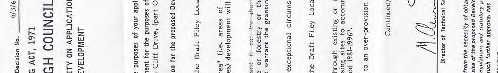
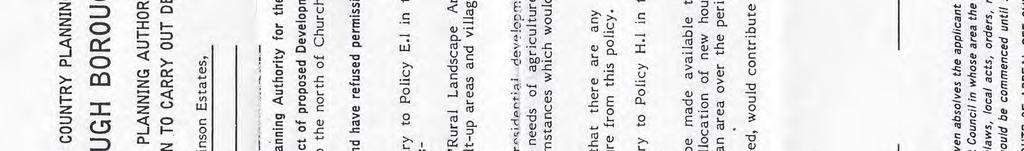
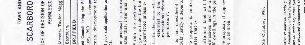
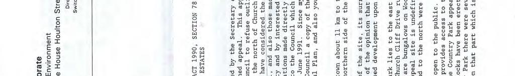
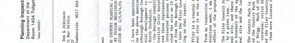
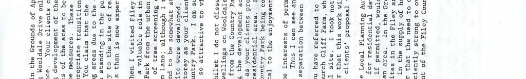
7 2 PLANNING HISTORY OF SITE HA Overview This Section sets out the previous planning history of Site HA 21. Relevant supporting information is provided in Appendix A. 2.2 Refusal of Outline Application for Residential Development on Site HA 21 An outline application for residential development to the north of Church Cliff Drive (part O.S. 7640), Filey was previously submitted by Messrs. Taylor Megginson Estates on 29 August 1990 to Scarborough Borough Council. Having considered this outline application, under Decision Number 4/3/674/PA, Scarborough Borough Council refused permission for the proposed development. The associated reasons for the refusal were that: 1) The proposal would be located outside the development limits of Filey (i.e. is contrary to Policy E.1 of the draft Filey Local Plan ); 2) The proposal would contribute to an over-provision of housing (i.e. is contrary to Policy H.1 in the draft Filey Local Plan ); and, 3) The proposal is likely to have a detrimental effect on the adjacent Country Park and Filey Brigg due to the reduction of the openness and remoteness at present experienced (i.e. is contrary to Policy L.10 in the draft Filey Local Plan ). Messrs. Taylor Megginson Estates submitted an appeal against this refusal to the Planning Inspectorate. Having considered the appeal, under Reference Number T/APP/H2733/A/91/180817/P8, the Planning Inspectorate agreed with the decision of Scarborough Borough Council and the appeal was dismissed. In agreeing with the decision of Scarborough Borough Council, the Planning Inspectorate noted the following points: 2.3 Summary I am of the opinion that the main issue in this appeal is the effect of the proposed development upon the Filey Country Park ; When I visited Filey I formed the impression that the appeal site performs a valuable role in providing physical and visual separation of the Country Park from the urban area of Filey ; It is my opinion that if the appeal site were developed, and even if the buildings were restricted to a single storey [ ] they would visually intrude into the Filey County Park. I am sure this would diminish its rural character which is so attractive to visitors ; I consider that your client s scheme would result in the Country Park being contiguous with the urban area, and this would be detrimental to the enjoyment of the Filey Country Park by visitors ; and, The interests of permanent residents and holidaymakers may not always coincide. This I can see an advantage to both parties in maintaining a physical separation between the Filey Country Park and the urban area. It is clear from the above information that Site HA 21 has previously been considered as a site for new housing delivery. However, both Scarborough Borough Council and the Planning Inspectorate have determined that the site is not appropriate for housing development. Furthermore, in the interim it is not considered that there have been any material changes to the site in terms of its environs (and thus suitability for development). Indeed, the Planning Inspectorate noted that: The Filey Country Park lies to the east of the appeal site, separated from it by a green lane. Church Cliff Drive runs along the southern site of the appeal site, and there are bungalows on Page 7
8 Wooldale Drive to the west. The northern boundary of the appeal site is undefined; at the time of my visit, the appeal site and the land to the north were carrying a crop of cereals. The Country Park is open to the public. Cars can be parked in this area, and the Country Park provides access to the cliffs and to the promontory of Filey Brigg. Much of the Country Park appears to be laid out for use by holiday caravans; toilet blocks have been erected and there is a shop. When I visited the Filey Country Park there were several caravans on this area, some of them were located on that part which is nearest to the appeal site. Therefore, it is considered that the reasons for refusal of an application for planning permission would also be applicable if an application were made today or, indeed, in the future. Page 8
9 3 PREVIOUS ASSESSMENTS OF SITE HA Introduction This Section examines the previous assessments of Site HA 21, and also the associated interpretation of those assessments. 3.2 Description of the Assessment Methodology The Housing Land Selection Methodology and Assessment Background Paper (May 2014) notes that the: methodology is used to provide the foundation from which the assessment and comparing of sites will take place in preparation for identification of land that will be allocated for housing in the Local Plan. Each site will be assessed in detail in order to establish the constraints, delivery potential and how it accords with the settlement hierarchy. Furthermore: the methodology proposes a 3 stage assessment of potential housing sites as follows: Stage A: Conformity with Settlement Strategy and determination of Major Constraints; Stage B: First Route Scoring: A preliminary test of the suitability of the site in achieving sustainable goals; and, Stage C: Detailed Site Implications: A test of the deliverability of a site including the identification of constraining factors that may prevent the feasibility or economic viability of development, and the capability of existing or required infrastructure to incorporate such development. It is also noted that: where any constraint or issue may be deemed significant enough to render a site undevelopable, the site could be dismissed at any stage during the process. Under the Section titled Explanation of Site Assessment Methodology, it is also noted that: the robust and responsive requirement for this assessment provides scope for ensuring each proposed site is tested in terms of its suitability for development, is deliverable and economically viable for developers and is economically, socially and environmentally sustainable. 3.3 Examination of the Previous Assessments of Site HA 21 The previous assessments of Site HA 21 are available in the following documents: Draft Housing Allocations DPD (Preferred Options): Supporting Information Site Assessments 2 (November 2009) (hereafter, Assessment A); and, The Housing Land Assessment Appendix C 3 (May 2014) (hereafter, Assessment B). The relevant extracts from these documents are provided in Appendix B. However, it should be noted that the above list of documents may not exhaustive and has been based on a high level internet search Assessment under Stage A: Conformity with Settlement Strategy and determination of Major Constraints Question 3: Is the site within the prescribed distance of any national or international site of biodiversity of geological value (e.g. SAC, SPA, RAMSAR, SSSI, National Nature Reserve), and if Yes, would the development have a negative impact on the associated area of protection? Assessment A noted No. However, Assessment B noted Yes and that the site lies within 5 km of the Flamborough Head SAC and SPA, and the Flamborough and Filey Coast pspa. However it is of such a scale and that it would only have a negligible impact on these protected habitat designations. Therefore, this is an inconsistency between the two assessments of Site HA Available at: 3 Available at: Page 9

10 Furthermore, information taken from notes that Site HA 21 is located less than 750 m from Filey Brigg SSSI. Figure 2 shows the location of Filey Brigg SSSI. FIGURE 2: LOCATION OF FILEY BRIGG SSSI Filey Brigg SSSI was designated in for both ornithological and geological interest. Indeed, the information from Natural England notes that: this is a new site identified as of national importance in the Geological Conservation Review. However, despite its earlier designation and the requirements of Question 3, Filey Brigg SSSI has not been considered in either Assessment A or Assessment B. This is an error in the assessment of Site HA 21. In terms of potential impacts, the Housing Land Selection Methodology and Assessment Background Paper (May 2014) notes (in terms of assessment of internationally designated sites) that these include: increased recreational pressure, particularly if the site is within 5 km of a protection designation area. This includes walking / trampling which causes soil compaction and erosion. Walkers with dogs contribute to pressure on sites through nutrient enrichment via dog fouling and also have potential to cause greater disturbance. This potential impact is also considered to be relevant to the assessment of nationally designated sites. Therefore, without proper consideration of Filey Brigg SSSI, including establishing the value of the existing ornithological and geological features, it is deemed highly inappropriate that a conclusion can be drawn on the significance of any potential impact (or indeed the success of any associated mitigation measures). Question 4: Does the site lie within an area considered to be unsuitable due to its position within a flood risk zone? Both Assessment A and Assessment B state No. However, there is a considerable amount of existing information relating to flood risk both on Site HA 21 and in the surrounding area that needs further consideration. Indeed, the latest Strategic Flood Risk Assessment 5 (SFRA) shows that Filey lies in an area at risk of groundwater and surface water flooding (Filey lies in Zone B: Burniston to Filey). This is shown in the Figures provided in Appendix C. Furthermore, based on this allocation, the latest SFRA also shows that Filey lies in a Critical Drainage Area. This is also shown on the Figures provided in Appendix C. Critical Drainage Areas occur in a number of locations across the latest SFRA Study Area where: an increase in the volume or rate of run-off from a site may increase the degree of flood risk elsewhere in the catchment. Such areas will be sensitive to the drainage system implemented 4 The reasons for the designation are given in: 5 Available at: Page 10
11 within a particular development site, as the drainage system design will determine site run-of rates. It does not appear that the assessment has given any consideration to the location of Site HA 21 within a Critical Drainage Area. Therefore, without proper consideration of the requirements of the Critical Drainage Area, it is deemed highly inappropriate that a conclusion can be drawn on the significance of any potential impact (or indeed the success of any associated mitigation measures). Furthermore, evidence collected from the proposed location of Site HA 21 is also included in Appendix C. This evidence comprises photographs taken at the site over a number of years. It does not appear that the assessment has given any consideration to the existing situation, and the potential for the existing problems due to flood risk to be exacerbated by the use of Site HA 2 for new housing development. Therefore, without proper consideration of the current situation, it is deemed highly inappropriate that a conclusion can be drawn on the significance of any potential impact (or indeed the success of any associated mitigation measures). Question 7: Where one of the above questions may have answered yes, does the constraint prohibit development of the entire site with no possibility of amending the site area? If Yes, the site is dismissed and if, as a result of amending the site boundaries, a site can no longer yield 10 dwellings or more, it will be dismissed. Based on the above, it is clear that the assessment of Site HA 21 under Stage A is not correct and it is not possible to determine whether or not Site HA 21 can pass the necessary criteria to proceed to assessment under Stages B and C. The remainder of the discussion in this Section is provided for completeness. However, it is considered extremely likely that, upon re-assessment, Site HA 21 would not pass the necessary criteria to proceed to assessment under Stages B and C Assessment under Stage B: First Round Screening N / A Assessment under Stage C: Detailed Site Implications Question 11: Would the development of the proposed site affect a regional or local site of biodiversity or geological value or affect any protected species / habitats? Both Assessment A and Assessment B provide a score of 1, which is noted to be no negative impact on existing features or where mitigation would allow appropriate development with no impact on biodiversity. However, it would seem that this score is provided on an incorrect basis, as the assessment have not considered that Site HA 21 is located less than 750 m from Filey Brigg SSSI which was designated in 1985 for both ornithological and geological interest. Indeed, the information from Natural England notes that: this is a new site identified as of national importance in the Geological Conservation Review. Therefore, without proper assessment of this site, including establishing the value of the existing ornithological and geological features, it is deemed highly inappropriate that a conclusion can be drawn on the significance of any potential impact (or indeed the success of any associated mitigation measures). Question 13: Would the proposed development affect the historic environment including the setting of an historic asset? Both Assessment A and Assessment B provide a score of 1, which is noted to be Development unlikely to impact on historic environment. There would be no impact or mitigation would allow Page 11
 Act 1990, the Council has a statutory duty to pay special attention to the")
12 features to be retained. However, Site HA 21 adjoins the boundary of Filey Conservation Area. Figure 3 shows the location of Filey Conservation Area 6 (dotted area outlined in red). FIGURE 3: LOCATION OF FILEY CONSERVATION AREA Under the provisions of the Planning (Listed Building and Conservation Areas) Act 1990, the Council has a statutory duty to pay special attention to the desirability of preserving or enhancing the character or appearance of its Conservation Areas. However, as noted in a response to the draft Local Plan by Ian Smith (English Heritage, Yorkshire and the Humber Region), there appears to be no evidence of any assessment being undertaken of the potential impact which the development of this area might have upon the setting of the Conservation Area. Furthermore, in order to demonstrate that the allocation of [Site HA 21] is not incompatible with the statutory duty placed upon the Council [ ], as part of the Evidence Base underpinning the [draft Local] Plan there needs to be an assessment of what contribution this currently undeveloped area makes to those elements which contribute to the significance of the Conservation Area, and what effect the loss of this site and its subsequent development might have upon those significances. Continuing, Ian Smith concludes that before allocating Site HA 21 for development: 1) An assessment needs to be undertaken of the contribution which this site makes to the elements which contribute towards the significance of the Filey Conservation Area and what impact the loss of this site and its subsequent development might have upon those significances. 2) If it is considered that the development of this site would harm elements which contribute to the significance of the Conservation Area, then the [draft Local] Plan needs to set out how that harm might be removed or reduced. If necessary, this needs to be included as a Criterion in the Housing Allocation Statement. 6 Available at: yment_site,committed_housing_sites,conareasall,development_limits,district_centre_boundary,employmen t_allocations,hc10_former_rugby_club_site,hc11_site_of_former_gas_showroom,housing_allocations,ope n_space_allocations,primary_shopping_area,proposed_new_road,protected_land_for_employment_use,rege neration_sites,sbc_boundary,sports_facility_allocations,strategic_growth_area,town_centre_boundary&lay ERS- VISIBLE=Amusement_Arcades,Cinder_Track,Committed_Employment_Site,Committed_Housing_Sites,Develop ment_limits,district_centre_boundary,employment_allocations,hc10_former_rugby_club_site,hc11_site_of _Former_Gas_Showroom,Housing_Allocations,Open_Space_Allocations,Primary_Shopping_Area,Proposed_New _Road,Protected_Land_for_Employment_Use,Regeneration_Sites,Sports_Facility_Allocations,Strategic_Growth _Area,Town_Centre_Boundary&ERRORS=true&TOOLBAR=search&LEGEND=true&TABS=layers Page 12
13 3) If at the end of the process, it is concluded that the development would still be likely to harm elements which contribute to the significance of the Conservation Area yet it is still considered appropriate to allocate the site, then the plan needs to set out what public benefits the development would provide and how these outweigh that harm (as required by NPPF, paragraph 133 / 134). Therefore, without proper assessment of the development within the context of the Filey Conservation Area, it is deemed highly inappropriate that a conclusion can be drawn on the significance of any potential impact (or indeed the success of any associated mitigation measures). Question 15: What is the impact on the landscape and does the landscape of the site have the ability to satisfactorily accommodate development? Both Assessment A and Assessment B provide a score of 1, which is noted to be Site can be developed without significantly impacting on the landscape. In addition, Assessment A notes that the site is raised up toward the rear although still of little real landscape value. Site [is] relatively hidden from main urban fabric of Filey and would do little to detract from its setting. However, this does not appear to be backed up by any evidence / assessment of the existing baseline landscape character (i.e. the quality and value of the existing landscape) or any associated assessment on the sensitivity of this landscape character (i.e. the ability of the landscape to accommodate change). In addition, as per the comments made on Question 13 above (i.e. the setting of an historic asset), there is no evidence of any assessment of the potential impact that the development of Site HA 21 would have on the setting of the Filey Conservation Area Therefore, without proper assessment of the existing baseline landscape character and sensitivity (including consideration the context of the Filey Conservation Area) it is deemed highly inappropriate that a conclusion can be drawn on the significance of any potential impact (or indeed the success of any associated mitigation measures). Question 16: Is the proposal within an area of flooding? [Noting that: sites deemed at a high risk of flood are likely to have been dismissed at Stage 1 of the Assessment Process]. Both Assessment A and Assessment B provide a score of 3, which is noted to be low probability of flooding. Development is appropriate. As noted previously, there is a considerable amount of existing information relating to flood risk both on Site HA 21 and in the surrounding area that needs further consideration. Therefore, without proper consideration of the requirements of the Critical Drainage Area and of the current situation, it is deemed highly inappropriate that a conclusion can be drawn on the significance of any potential impact (or indeed the success of any associated mitigation measures). Question 21: What is the capacity of existing utilities (Water, Sewage, etc) to cope with the development? Both Assessment A and Assessment B provide a score of 2, which is noted to be sufficient capacity or constraints can be overcome through, for example, planned growth of housing with investment from utilities provider. Housing development may have to be delayed until the installation of relevant services. In addition, Assessment A notes that there are significant waste water treatment works capacity constraints associated with Filey. However, individually the number of dwellings associated with this development would not push the [Waste Water Treatment Works] over capacity. The cumulative impact and any restrictions on total development in Filey will have to be considered separately. Page 13
14 However, this is in direct conflict a response to the Housing Allocations Development Plan Document (DPD) Preferred Options 7 by Matthew Gibson (Yorkshire Water Services Limited (Land, Property and Planning)) who noted that whilst there is adequate capacity in the public foul sewer network to take foul water flows equal to the existing discharge rate from the proposal site, [ ] the local public sewer network may not have capacity to accept any additional discharge of surface water from the proposed site. Therefore, it is not clear that a conclusion can be drawn that the number of dwellings associated with this development would not push the [Waste Water Treatment Works] over capacity. Question 23: Is the highway network (local) able to safely and efficiently cope with this development? Both Assessment A and Assessment B provide a score of 2, which is noted to be sufficient capacity or constraints can be overcome through, for example, planned growth of housing in line with infrastructure improvements. In addition, both assessments note that access [is] available from both Wooldale Drive and Church Cliff Drive with no impact on [the] local network. However, this statement does not seem to have been carried through for input in the draft Local Plan, which (as noted in Section 1) states that: the site will be accessed from the existing connection off Wooldale Drive. Therefore, it is not clear why there is an inconsistency in the interpretation of Assessment A and Assessment B, and why a conclusion has been drawn that access should now be restricted to Wooldale Drive only. Question 24: Would the development of the site be compatible with adjoining land uses (now or in the future) or are there any conflicts / amenity issues? Both Assessment A and Assessment B provide a score of 2, which is noted to be with mitigation, development would be compatible. In addition, Assessment A notes that the development could be integrated with existing dwellings to the west [and] caravan park adjacent to the east. However, this is screened by vegetation and could be compatible. This is in direct conflict with both the conclusions of Scarborough Borough Council and the Planning Inspectorate on a previous outline application for residential development on Site HA 21. These conclusions have been summarised in Section 2. In addition, as noted above, there has been no proper assessment of Site HA 21, in particular with respect to: Filey Brigg SSSI; the adjacent Conservation Area; the surrounding landscape character and sensitivity; and, the existing situation with regards to flooding and drainage. Furthermore, as noted in a response to the Housing Allocations Development Plan Document (DPD) Preferred Options 8 by Matthew Gibson (Yorkshire Water Services Limited (Land, Property and Planning)) there is sewerage infrastructure crossing the site [and, therefore] stand off distances for each sewer will apply and so affect the layout of future development. Also, as noted in a response to the draft Local Plan by Stephanie Waldon (Yorkshire Water) there are two 350mm rising mains laid within the site boundary and their presence must be taken into account in any future site layout (it may not be possible to divert them). Failure to protect the mains or prevent YW from being able to properly repair and maintain them, could jeopardise the public sewer network. Moreover, absolutely no consideration has been given to the existing residents of the surrounding area, in particular those on Wooldale drive which are adjacent to the western boundary of Site HA Available at: on Available at: on Page 14
15 Therefore, without a full understanding of the current situation and the associated restrictions on the final site size and available area for development / layout restrictions, it is clearly highly inappropriate to draw a conclusion that the development would be compatible, particularly when the opposite conclusion has been drawn in the past. Indeed, without any understanding of the current situation no conclusion can be drawn on the significance of any potential impact (or indeed the success of any associated mitigation measures). 3.4 Interpretation of Previous Assessments of Site HA 21 Interpretations of the previous assessments are available in the following documents: Housing Allocations Development Plan Document (DPD) Preferred Options 9 (January, 2010) (hereafter, Interpretation A); and, The Strategic Housing and Employment Land Availability Assessment (SHELAA) 10 (March, 2014) (hereafter, Interpretation B). The relevant extracts from these documents are provided in Appendix D. However, as before, it should be noted that this list of documents is not exhaustive and has been based on a high level internet search. It is understood that Interpretation A (taken as a conclusion from Assessment A) and Interpretation B (taken as a conclusion from Assessment B) have been used as the basis for the proposed inclusion of Site HA 21 as an allocated site under Policy HC 2 of the draft Local Plan for new housing delivery. However, these interpretations are not consistent. The most obvious inconsistency is the conclusion regarding the estimated yield of houses which may be placed on Site HA 21. Whilst Interpretation A (the earlier interpretation) notes that the estimated yield is 34 dwellings, Interpretation B (the later interpretation) notes that the estimated yield is 53 dwellings. This represents an increase of over 50% of the yield, all without any obvious or significant difference between Assessment A and Assessment B (indeed, the assessment is exactly the same, giving the same scores). 3.5 Summary Based on the information contained within this Section on the previous assessments and associated interpretations of Site HA 21, it is obvious that re-assessment is required. It is considered extremely likely that, upon re-assessment, Site HA 21 would not pass the necessary criteria to pass Stage A of the assessment, and therefore proceed to assessment under Stages B and C. It is also clear from the information contained in this Section that there is a need for transparent and consistent assessment of Site HA 21 which is based on a full understanding of the current situation. Indeed, the above serves to demonstrate and highlight the somewhat careless approach to the previous assessment of Site HA 21. It is considered that until this re-assessment has taken place it is not appropriate to include Site HA 21 as an allocated site under Policy HC 2 of the draft Local Plan as the re-assessment may deem it to be an inappropriate site for new housing development. 9 Available at: Available at: Page 15
16 4 SUMMARY OF CONFLICTS WITH OTHER RELEVANT POLICIES OF THE DRAFT LOCAL PLAN 4.1 Introduction This Section summaries the conflict of the use of Site HA 21 with other relevant policies of the draft Local Plan. The full text of the policies discussed is provided in Appendix E. 4.2 Policy DEC 2: The Efficient Use of Land and Buildings Under proposed Policy DEC 2 it is stated that: the density of development (including any associated elements of green infrastructure) should be in keeping with the character of the local area. Higher densities will be more appropriate in the central areas of Scarborough, Whitby and Filey. Lower densities may be considered acceptable in instances where there are site-specific constraints, a need to provide additional levels of infrastructure or where the current character or appearance of the area necessitates a development of a lower density. As noted previously in Section 2, both the Scarborough Borough Council and the Planning Inspectorate have deemed that the use of Site HA 21 for residential development would not be in keeping with the character of the local area. Indeed, the Planning Inspectorate has stated that: if the [ ] site were developed, and even if the buildings were restricted to a single storey [ ] they would visually intrude into the Filey County Park. I am sure this would diminish its rural character which is so attractive to visitors. Furthermore, as noted previously in Section 3, there is a lack of consideration which has been given to the current situation and the associated restrictions on the final site size and available area for development / layout restrictions. Indeed, and as a result of this lack of consideration, there is no firm conclusion on the estimated yield of houses which could be placed on Site HA 21. It is considered that the proposed density of development, understood to be 30 houses per hectare, would not be in keeping with the current local context, yet this factor has not been taken into consideration. Therefore, it is considered that use of Site HA 21 for residential development would be in conflict with this proposed policy. 4.3 Policy DEC 3: Protection of Amenity Under proposed Policy DEC 3 it is stated that: all development should ensure that existing and future occupants of land and buildings are provided with a good standard of amenity. Proposals for development should not give rise to unacceptable impacts by means of: Overbearing impact; Overlooking and loss of privacy; Disturbance arising from such things as noise, light pollution and other activities; Emissions including smells and other pollutants; Overshadowing or loss of natural light. The criteria listed above are not exhaustive and development that causes significant harm to amenity by means of these or other impacts will not be permitted. As noted previously in Section 3, there is a lack of consideration which has been given to the current situation and, indeed, absolutely no consideration has been given to the existing residents of the surrounding area, in particular those on Wooldale Drive which are adjacent to the western boundary of Site HA 21. Therefore, it is considered that use of Site HA 21 for residential development would be in conflict with this proposed policy. 4.4 Policy DEC 4: The Historic and Built Environment Under proposed Policy DEC 4 it is stated that: proposals affecting a Conservation Area should preserve or enhance its character or appearance, especially those elements identified in any Conservation Area Appraisal. Page 16
17 As noted previously in Section 3, Site HA 21 adjoins the boundary of Filey Conservation Area. Under the provisions of the Planning (Listed Building and Conservation Areas) Act 1990, the Council has a statutory duty to pay special attention to the desirability of preserving or enhancing the character or appearance of its Conservation Areas. However, as noted in a response to the draft Local Plan by Ian Smith (English Heritage, Yorkshire and the Humber Region), there appears to be no evidence of any assessment being undertaken of the potential impact which the development of this area might have upon the setting of the Conservation Area. Therefore, it is considered that use of Site HA 21 for residential development would be in conflict with this proposed policy. 4.5 Policy HC 1: Supporting Housing Development Under proposed Policy HC 1, it is stated that new opportunities for housing development will be encouraged where proposals are compatible with other policies in the Local Plan. As per the information provided in this Document, it is considered that use of Site HA 21 for residential development would be in conflict other policies in the Local Plan. Therefore the use of Site HA 21 for residential development would also be in conflict with this proposed policy. 4.6 Policy ENV 2: Environmental Risk Under proposed Policy ENV 2 it is stated that: proposals will be expected to respond to the implications of environmental risk and the effects of climate change. This will be achieved by (amongst other actions): avoiding development in high flood risk areas by following a sequential approach in giving priority to lowest risk areas as identified by the North-East Yorkshire Strategic Flood Risk Assessment or any subsequent update or replacement. As noted previously in Section 3, there is a considerable amount of existing information relating to flood risk both on Site HA 21 and in the surrounding area that needs further consideration. Therefore, it is considered that use of Site HA 21 for residential development may be in conflict with this proposed policy. 4.7 Policy ENV 4: The Natural Environment Under proposed Policy ENV 4 it is stated that proposals should ensure that: development does not result in an unacceptable impact on any locally, nationally or internationally designated sites unless the impact can be outweighed by a greater benefit as commensurate to the designation. As noted previously in Section 3, Site HA 21 is located less than 750 m from Filey Brigg SSSI. This site was designated in 1985 for both ornithological and geological interest. Indeed, the information from Natural England notes that: this is a new site identified as of national importance in the Geological Conservation Review. However, despite its earlier designation and the previous assessment of Site HA 21, the potential impacts on Filey Brigg SSSI have not been fully considered. Therefore, it is considered that use of Site HA 21 for residential development may be in conflict with this proposed policy. 4.8 Policy ENV 5: Development Affecting the Countryside Under proposed Policy ENV 5 it is stated that: the character of the open countryside will be protected, maintained and where possible enhanced. Outside the defined development limits, new developments will be limited to those for which a countryside location is essential. As noted previously in Section 2, both the Scarborough Borough Council and the Planning Inspectorate have deemed that the use of Site HA 21 for residential development would be outside the defined development limits. Indeed, this was one of the key reasons for the refusal of permission of the proposed development. Furthermore, as shown in Appendix C, Interpretation B states, under other constraints, that the site is located outside Development Limits. Figure 4, extracted from the existing Local Plan Proposals Map from 1999, shows the existing defined development limits (the orange dashed line, Page 17


18 shown to run to the south and west of Site HA 21). Figure 4 clearly indicates that Site HA 21 is not included within the existing defined development limits. FIGURE 4: LOCATION OF EXISTING DEFINED DEVELOPMENT LIMITS Defined development limits enable a different approach to be taken between the towns / villages and the countryside. Therefore, in planning terms, the defined development limits provide a clear distinction between those parts of the settlement where development is acceptable, in principle, and those parts of the settlement which should be treated as open countryside where development should be restricted. Through reducing the outward expansion into the countryside, development limits help to retain the character of the area and assist in more sustainable development. In terms of the existing defined development limits, as noted in Section 2, it has been determined that Site HA 21: performs a valuable role in providing physical and visual separation of the Country Park from the urban area of Filey. Therefore, this is a key reason why the existing defined development limits do not include Site HA 21. However, Figure 5, extracted from the draft Local Plan Proposals Map, shows re-defined development limits specifically to include Site HA 21. FIGURE 5: PROPOSED LOCATION OF RE-DEFINED DEVELOPMENT LIMITS This re-definition of the defined development limits is particularly alarming, especially when there is no reference to any assessment which has been undertaken to confirm whether the re-definition is appropriate. Indeed, this re-definition is in complete conflict to the previous position of both Page 18
19 Scarborough Borough Council and the Planning Inspectorate on Site HA 21 which reinforced its position outside the defined development limits. Indeed, if this re-definition has been based on the previous assessment and associated interpretations of Site HA 21 it is previously been concluded that this is significantly flawed, and is full of inconsistencies and errors. Therefore, it is considered that use of Site HA 21 for residential development would be in conflict with this proposed policy, and also the associated re-definition of the development limits needs further transparent and consistent assessment. Page 19
20
21 APPENDIX A
22
23
24
25
26


27
28
29 APPENDIX B
30
31 Site Assessment 03/06 Site Ref: 03/06 Area (ha): 1.76 ha Parish: Filey Address: Land at Church Cliff Drive, opposite Church Cliff Farm Map: Site 03/06; Map 4 Filey Score: Stage A: Passed Stage B: 7 Stage C: 25 Concluding Comments: Site offers opportunity for development within Filey that is of a scale that would not cause capacity issues. The site would be deemed a logical expansion within the existing town area and may form an extension to Wooldale Drive. Design considerations should be placed upon proximity to Listed Church Cliff Farm, and entrance to Caravan Park however, this could be overcome with a sympathetic scheme that enhances this area of Estimated Yield: Filey. 34 dwellings. Prior to Stage A, all sites that cannot accommodate 10 or more dwellings will be dismissed from the formal allocation process in the Housing Allocations DPD but will be considered to determine if the development limits can be amended to allow small scale housing or be suitable for an exceptions site. Stage A: Conformity with Settlement Strategy and Major Constraints A(i) Conformity with the evolving Scarborough Borough settlement strategy: Question 1) Does the proposed site lie within or is well related to an existing settlement? YES / NO If Yes, proceed to Question 2. If No, site is dismissed. Question 2) Is the site of an appropriate scale/size that reflects the housing distribution as defined in settlement hierarchy within Core Strategy? YES / NO If Yes, proceed to Question 3. If No, proceed to Question 2b. Question 2b) Could a smaller portion of the site be in conformity with the distribution strategy? YES / NO / N/A If Yes, proceed to Question 3. If No, site is dismissed. A(ii) Major Constraints (Environmental and Historic) Question 3) Would the development of the site have a negative effect (direct or indirect) on any national or international site of biodiversity or geological value; e.g. RAMSAR, SSSI? YES / NO Question 4) Does the site lie within an area considered to be unsuitable due to its position within a flood risk zone (high risk)? YES / NO Question 5) Does the site lie within an area considered to be at significant risk of coastal erosion zone, i.e. located within 100 year erosion zone? YES / NO 162
32 Question 6) Would the development of the site have an adverse negative impact upon nationally-important archaeology (including Scheduled Monuments) or other high-grade historic assets or their settings? YES / NO If No to all questions 3 to 6, proceed to Question 8 If Yes, proceed to Question 7 Question 7) Where one of the above questions may have answered yes, does the constraint prohibit development of the entire site with no possibility of amending the site area? YES / NO / N/A If Yes, site is dismissed. If, as a result of amending site boundaries, a site can no longer yield 10 dwellings or more, it will be dismissed. Where 10 dwellings may be yielded, proceed to Question 8 Stage B: First Round Scoring Question 8) Brownfield or Greenfield Land Is the site classified as previously developed land (Brownfield), Greenfield or is it a mixture of both land types? 100% Brownfield 6 Majority Brownfield 4 Majority Greenfield 2 100% Greenfield 1 POINTS 1 Question 9) Accessibility of site to pre-determined areas by public transport This question, along with Question 10, relate to accessibility. With the use of Accession Software, complex transport modelling is utilised to enable the relative accessibility of potential sites to pre-determined services and facilities by sustainable modes such as public transport, walking and cycling. Destination To Retail / Leisure Centres (Scarborough, Whitby, Filey, Neighbourhood Centres and Service Villages) To major employment centres (town centres or Business Parks) To Primary Schooling To Secondary Less than 15 mins Journey time to Destination by Public Transport 15 to to to 60 mins mins mins More than 1 hour Schooling To GP Surgery TOTAL 30 Question 10) How accessible is the site to existing services and facilities? 163
33 Destination Defined town and service centres Major employment centres Primary Schools Secondary Walking Distances within Cycling Distances within 500m 1000m 2000m 1.5km 5km 8km Schools Train Station GP Surgeries TOTAL 41 Total Scores from Questions 9 and pts > 61 6 Score: 6 Stage C: Detailed Site Implications At any stage of this process, where a constraint to development may be so significant, the site could require dismissing. Question 11) Regional and Local Biodiversity Would the development of the proposed site affect a regional or local site of biodiversity or geological value or affect any protected species/habitats? Positive Impact Neutral Impact Adverse Impact Significant Adverse Impacts Assessment / Comments Features retained, improved or successfully integrated into the development. 3 pts No negative impact on existing features or where mitigation would allow appropriate 1 development with no impact on biodiversity. Some negative impacts that cannot be entirely mitigated against. -2 Features will not be retained. No mitigation measures overcome impacts or are possible. -3 No impact on designated site. Score 1 Question 12) Trees and Hedgerows Would the development of the site affect trees or hedgerows not covered by statutory protection or by the BAP? Positive Impact Neutral Impact Adverse Impact Trees and hedgerows retained, improved or successfully integrated into the development. There would be no impact or mitigation would allow appropriate development. Some negative impacts that cannot be entirely mitigated against
34 Significant Adverse Impacts Assessment / Comments Trees and hedgerows destroyed or damaged. No mitigation measures overcome impacts or are possible. No significant vegetation on site although hedgerows screen site from adjacent Caravan Park. It would be likely these would be retained with development. -2 Score 1 Question 13) Historic Environment Would the proposed development affect the historic environment including the setting of an historic asset? Positive Impact Opportunity for enhancement of features. 3 Neutral Impact Development unlikely to impact on historic environment. There would be no impact or 1 mitigation would allow features to be retained. Adverse Impact Proposal likely to adversely affect the historic environment. Features may be lost in part, although mitigation may prevent significant -2 impact. Significant Adverse Impacts Significant adverse effect on the historic environment, with features lost and no -3 Assessment / Comments possible mitigation. Church Cliff Farm is a listed building located to the south over Church Cliff Drive. Design could assist in ensuring the impact upon the building is insignificant. Score 1 Question 14) Character of Built Area Would the development affect the built character of the town or village? Positive Impact Development would enhance area through redevelopment or by bringing vacant and 3 derelict buildings back into use. Neutral Impact No or very little impact. 1 Adverse Impact Proposal likely to have slight adverse affect the character of the town or village. Some features may be lost in part, although mitigation may prevent significant impact. -1 Significant Adverse Impacts Assessment / Comments Significant adverse effect on the built character of the town or village, with features lost and no possible mitigation. Proximity to the Listed Building would guarantee high quality design at the southern end of the site but consideration should also be placed on ensuring integration with existing dwellings to the west at Wooldale Drive. -3 Score 1 Question 15) Impact on the Landscape What is the impact on landscape and does the landscape of the site have the ability to satisfactorily accommodate development? 165
35 High Capacity Mid Capacity No impact Low Capacity Major negative impact on landscape Assessment / Comments The development of the site would not impact significantly on the landscape. Features will be retained or the existing landscape is poor. Site can be developed without significantly impacting on the landscape. Not relevant as site lies within an urban environment. Partial features may be lost and there may be a negative impact on the landscape. Mitigation may lessen any impact but will not overcome all constraints. Development will likely have a significant negative impact on the landscape, features may be lost and mitigation will not satisfactorily overcome concerns. Site raised up toward the rear although still of little real landscape value. Site relatively hidden from main urban fabric of Filey and would do little to detract from its setting Score 1 Question 16) Flood Risk Is the proposal within an area at risk of flooding? Note: Sites deemed at a high risk of flooding are likely to have been dismissed at Stage 1 of assessment process. Zone 1 Zone 2 Assessment / Comments Low probability of flooding. Development is appropriate. 3 Medium probability of flooding. Development is appropriate subject to any required 1 mitigation. Flood zone 1. Score 3 Question 17) Agricultural land Would the development of the site result in the loss of the best and most versatile agricultural land? No loss 2 Loss of 0.1ha 5ha -1 Loss of 5.1ha 10ha -2 Loss of 10.1ha 20ha -3 More than 20ha -4 Assessment / Comments Grade 3 Score 2 Question 18) Water Supply and Groundwater Source Protection Zones Would the development adversely affect a water supply? No impact from development on water supply. 3 Any impact from development could successfully be mitigated against. 2 Site located within Protection Zone with no mitigation possible and serious risks of contamination. Site to be dismissed Assessment / Comments No impact on water supply Score 3 166
36 Question 19) Mineral Resources Would the development of the land impact on mineral resources? Site does not affect any mineral resource or any preferred area of search identified in relevant Minerals and Waste Plans or LDF 2 Documents. Site may affect an area of mineral resources or a potential preferred area of search, however, extraction could happen before development. 1 Development may not be suitable immediately. Site lies within an identified area for mineral resources and no mitigation possible (i.e. pre-extraction). -2 Assessment / Comments No impact on mineral resources Score 2 Infrastructure Question 20) School Capacity What is the capacity of schools to cope with the development? Sufficient capacity or constraints can be overcome through, for example, s106. Refer to the NYCC investment plan. 2 Insufficient capacity and constraints cannot be overcome. -2 Assessment / Comments Sufficient school capacity. Score 2 Question 21) Capacity of Utility Providers What is the capacity of existing utilities (Water, Sewage, etc) to cope with the development? Sufficient capacity or constraints can be overcome through, for example, planned growth of housing with investment from utilities provider. Housing development may have to be delayed until the installation of relevant infrastructure. Insufficient capacity and constraints cannot be overcome; i.e. levels of development do not warrant investment from Infrastructure providers to bring current facilities up to spec. Assessment / Comments Significant Waste Water Treatment Works Capacity constraints associated with Filey, however, individually the number of dwellings associated with this development would not push the WWTW over capacity. The cumulative impact and any restrictions on total development in Filey will have to be considered separately. 2-2 Score 2 Question 22) Impact on Strategic Highway Network Does the development have an adverse impact on the Strategic Road Network? Development does not negatively impact on the safe and efficient operation of the network or infrastructure improvements to accommodate development are feasible and have a suitable identified funding sources and delivery plan
37 Insufficient capacity and constraints cannot be overcome. -2 Assessment / Comments No impact on strategic highway network. Score 2 Question 23) Impact on Local Highways Network Is the highway network (local) able to safely and efficiently cope with this development? Sufficient capacity or constraints can be overcome through, for example, planned growth of housing in line with infrastructure improvements. Insufficient capacity and constraints cannot be overcome. -2 Assessment / Score 2 Comments Access available from both Wooldale Drive and Church Cliff Drive with no impact upon local network. 2 Amenity Issues Question 24) Land Use Conflicts Would the development of the site be compatible with adjoining land uses (now or in the future) or are there conflict / amenity issues? Yes Development compatible. 2 Yes With mitigation, development would be compatible. 2 No Incompatible with adjoining uses and mitigation unlikely to be available. -3 Assessment / Comments Development could be integrated with existing dwellings to the west. Caravan Park adjacent to the east, however, this is screened by vegetation and could be compatible. Score 2 Question 25) Other Issues and Constraints Are there any other constraints that affect the site? No No Yes Assessment / Comments No known constraints Some constraints but mitigation possible Constraints exist and mitigation unlikely. The site is in an area identified in the SFRA as being a Drainage Sensitive Area. Availability and Deliverability Question 26) Ownership Are there any ownership constraints? No Yes Owner has submitted site and is willing to sell Ownership constraints or little developer interest Question 27) Timescale for Development 168
38 Is the site likely to be developed within 15 years of the adoption of the Housing DPD? Within 5 years Beyond 5 years Mid-to-late period and prior end of Housing Allocations DPD (2026) Not likely to be developed prior to 2026 Site can be developed within first 5 years and any constraints can be overcome. Constraints exist but likely to be overcome and delivered within short-medium term. Although constraints could be mitigated against it would be deemed unlikely in the short-medium period although still anticipated within LDF period. Constraints exist and mitigation unlikely before Not allocated but re-considered at a future date. Overall Assessment of Deliverability Any comments on estimated yield; overarching constraints, justification or mitigation; revised site boundary where necessary for instance. Although the south of the Borough suffers from Waste Water Treatment Works capacity constraints, it is likely development of this site would fall under the estimated threshold at which expansion of the Treatment Works would be required. The site forms a logical rounding-off of this aspect of Filey. Access is readily available whilst the land, although sloping up to its rear, is not particularly prominent and offers little to the character of the area. Church Cliff Farm opposite the site is a listed building thus a requirement is needed for assurances over design that integrates not only with this but also existing dwellings adjacent to the east at Wooldale Drive. This site would be the preferential option for development within Filey. Estimated Yield 34 dwellings. 169
39 Site Assessment Housing Allocations HA 21 Reference: Site Ref: 03/06 Area (ha): 1.7 ha Parish: Filey Address: Land at Church Cliff Drive, opposite Church Cliff Farm Score: Stage A: Pass Stage B: Stage C: 25 Concluding Comments: Site offers opportunity for development within Filey that is of a scale that would not cause capacity issues. The site would be deemed a logical expansion within the existing town area and may form an extension to Wooldale Drive. Design considerations should be placed upon proximity to Listed Church Cliff Farm, and entrance to Caravan Park however, this could be overcome with a sympathetic scheme that enhances this area of Filey. Indicative Yield: The site was considered appropriate for allocation at the Preferred Options stage and this remains the recommendation of officers. 50 dwellings. Prior to Stage A, all sites that cannot accommodate 10 or more dwellings will be dismissed from the formal allocation process in the Local Plan but will be considered to determine if the development limits can be amended to allow small scale housing or have the potential to be suitable as an exceptions site in the rural area. Stage A: Conformity with Settlement Strategy and Major Constraints A(i) Conformity with the evolving Scarborough Borough settlement strategy: Question 1a) Does the proposed site lie within or is well related to an existing settlement? YES / NO If Yes, proceed to Question 1b. If No, site is dismissed. Question 1b) Does the settlement lie within or above the Service Village classification? YES / NO If Yes, proceed to Question 2a. If No, proceed to Question 1c. Question 1c) Are there any circumstances that would warrant an allocation of housing within the settlement? YES / NO If Yes, proceed to Question 2a. If No, site is dismissed. Question 2a) Is the site of an appropriate scale/size that reflects the role of the respective settlement as defined in the settlement hierarchy within the Local Plan? YES / NO If Yes, proceed to Question 3. If No, proceed to Question 2b. 11
40 Question 2b) Could a smaller portion of the site be in conformity with the settlement hierarchy? YES / NO If Yes, proceed to Question 3. If No, site is dismissed. A(ii) Major Constraints (Environmental and Historic) Question 3a) Is the site within the prescribed distance of any national or international site of biodiversity or geological value; e.g. RAMSAR, SSSI, SAC, SPA, National Nature Reserves? YES / NO Question 3b) If YES would the development have a negative impact on the associated area of protection? YES/NO EXPLAIN. The site lies within 5km of the Flamborough Head SAC and SPA, and the Flamborough and Filey Coast pspa, however, it is of such a scale that it would only have a negligible impact on these protected habitat designations Question 4) Does the site lie within an area considered to be unsuitable due to its position within a flood risk zone (high risk)? YES / NO Question 5) Does the site lie within an area considered to be at significant risk of coastal erosion zone, i.e. located within 100 year erosion zone? YES / NO Question 6) Would the development of the site have an adverse negative impact upon nationallyimportant archaeology (including Scheduled Monuments) or other high-grade historic assets or their settings? YES / NO If No to all questions 3 to 6, proceed to Question 8 If Yes, proceed to Question 7 Question 7) Where one of the above questions may have answered yes, does the constraint prohibit development of the entire site with no possibility of amending the site area? YES / NO / N/A If Yes, site is dismissed. If, as a result of amending site boundaries, a site can no longer yield 10 dwellings or more, it will be dismissed. Where 10 dwellings may be yielded, proceed to Question 8 Stage B: First Round Scoring Question 8) Brownfield or Greenfield Land Is the site classified as previously developed land (Brownfield), Greenfield or is it a mixture of both land types? 100% Brownfield 6 Majority Brownfield 4 Majority Greenfield 2 100% Greenfield 1 POINTS 1 Question 9a) Accessibility of site to pre-determined areas by public transport This question, along with Question 10, relate to accessibility. With the use of accessibility software, complex transport modelling is utilised to enable the relative accessibility of potential sites to predetermined services and facilities by sustainable modes such as public transport, walking and cycling. Destination Journey time to Destination by Public Transport 12
41 Defined town centres, service centres and neighbourhood centres. Major employment centres. Indoor Sports Centres / Pools Less than 15 mins 15 to 30 mins 30 to 45 mins 45 to 60 mins More than 1 hour Primary Schools Secondary Schools GP Surgeries TOTAL 32 Question 9b) How accessible is the site to existing services and facilities? Destination Defined town centres, service centres and neighbourhood centres. Major employment centres Indoor Sports Centres / Pools Walking Distances within Cycling Distances within 500m 1000m 2000m 1.5km 5km 8km Primary Schools Secondary Schools Train Station GP Surgeries TOTAL 39 Question 10) Accessibility of site to pre-determined areas for leisure and recreation Destination Within Pre-determined range 350m (5 mins) 700m (10 mins) 1000m (15 mins) Informal Open Space for Recreation Outdoor Sports Pitches and Facilities Local Children s Play Area Neighbourhood Children s Play Area Settlement Level Children s Play Area Total 3 Comparison Scores for Q8 to 10 Brownfield / Greenfield Accessibility to Services Accessibility to Recreation
42 Stage C: Detailed Site Implications At any stage of this process, where a constraint to development may be so significant, the site could require dismissing. Question 11) Regional and Local Biodiversity Would the development of the proposed site affect a regional or local site of biodiversity or geological value or affect any protected species/habitats? Assessment / Comments No impact on designated site. Score 1 Question 12) Trees and Hedgerows Would the development of the site affect trees or hedgerows not covered by statutory protection or by the BAP? Assessment / Comments No significant vegetation on site although hedgerows screen site from adjacent Caravan Park. It would be likely these would be retained with development. Score 1 Question 13) Historic Environment Would the proposed development affect the historic environment including the setting of an historic asset? Assessment / Comments Church Cliff Farm is a listed building located to the south over Church Cliff Drive. Design could assist in ensuring the impact upon the building is insignificant. Score 1 Question 14) Character of Built Area Would the development affect the built character of the town or village? Assessment / Comments Proximity to the Listed Building would guarantee high quality design at the southern end of the site but consideration should also be placed on ensuring integration with existing dwellings to the west at Wooldale Drive. Score 1 Question 15) Impact on the Landscape What is the capacity of the landscape to accommodate development with respect to the conservation and enhancement of distinctive rural and coastal landscape character areas? Assessment / Comments The site lies in an area designated as D4 (Lebberston and Filey) Coastal Hinterland. This area has a sense of openness and visual relationships with the coast. Score 1 14
43 This site is raised up toward the rear although still of little real landscape value. The site is relatively hidden, is disconnected from the main landscape beyond towards the coast and is more connected to the main urban fabric of Filey. The development of this site would do little to detract from its setting within the wider landscape. Question 16) Flood Risk Is the proposal within an area at risk of flooding? Note: Sites deemed at a high risk of flooding are likely to have been dismissed at Stage 1 of assessment process. Assessment / Comments Flood zone 1. Score 3 Question 17) Agricultural land Would the development of the site result in the loss of the best and most versatile agricultural land? Assessment / Comments Grade 3 Score 2 Question 18) Water Supply and Source Protection Zones Would the development adversely affect a water supply? Assessment / Comments No impact on water supply Score 3 Question 19) Mineral Resources Would the development of the land impact on mineral resources? Assessment / Comments No impact on mineral resources Score 2 Infrastructure Question 20) School Capacity What is the capacity of schools to cope with the development? Assessment / Comments Sufficient school capacity. Score 2 Question 21) Capacity of Utility Providers What is the capacity of existing utilities (Water, Sewage, etc) to cope with the development? Assessment / Comments Significant Waste Water Treatment Works Capacity constraints associated with Filey, however, individually the number of dwellings associated with this development would not push the WWTW over capacity. The Score 2 15
44 cumulative impact and any restrictions on total development in Filey will have to be considered separately. Question 22) Impact on Strategic Highway Network Does the development have an adverse impact on the Strategic Road Network? Assessment / Comments No impact on strategic highway network. Score 2 Question 23) Impact on Local Highways Network Is the highway network (local) able to safely and efficiently cope with this development? Assessment / Comments Access available from both Wooldale Drive and Church Cliff Drive with no impact upon local network. Score 2 Amenity Issues Question 24) Land Use Conflicts Would the development of the site be compatible with adjoining land uses (now or in the future) or are there conflict / amenity issues? Assessment / Comments Development could be integrated with existing dwellings to the west. Caravan Park adjacent to the east, however, this is screened by vegetation and could be compatible. Score 2 Question 25) Other Issues and Constraints Are there any other constraints that affect the site? Assessment / Comments The site is in an area identified in the SFRA as being a Drainage Sensitive Area. Availability and Deliverability Question 26) Ownership Are there any ownership constraints? No Yes Owner has submitted site and is willing to sell Ownership constraints or little developer interest Question 27) Timescale for Development Is the site likely to be developed within the Local Plan period up to 2030? Within 5 years Site can be developed within first 5 years and any constraints can be overcome. Overall Assessment of Deliverability 16
45 Any comments on estimated yield; overarching constraints, justification or mitigation; revised site boundary where necessary for instance. Although the south of the Borough suffers from Waste Water Treatment Works capacity constraints, it is likely development of this site would fall under the estimated threshold at which expansion of the Treatment Works would be required. The site forms a logical rounding-off of this aspect of Filey. Access is readily available whilst the land, although sloping up to its rear, is not particularly prominent and offers little to the character of the area. Church Cliff Farm opposite the site is a listed building thus a requirement is needed for assurances over design that integrates not only with this but also existing dwellings adjacent to the east at Wooldale Drive. This site would be the preferential option for development within Filey. Indicative Yield 50 dwellings. 17
46
47 APPENDIX C
48
49 Blue Dolphin Holiday Park!(!( %, %, Hunmanby!( Filey!( Primrose Valley Holiday Village!( Reighton!( Reighton Sands Holiday Village!( Legend %, Admiral House Rose Wharf 78 East Street Leeds LS9 8EE Client Job Title Drawing Title Scale at A1 Reported Groundwater and Surface Runoff Flooding Reported Surface Runoff Flooding!(!( Large settlements Medium settlements!( Small settlements!( Holiday Parks NOTES: Zone A: A64(T) - Rillington to Hunmanby Corridor Zone B: Coastal Belt - Burniston to Filey Zone C: A170 - Helmsley to Seamer Corridor Zone D: North York Moors National Park Northeast Yorkshire Study Area 1) For indication only 2) The locations of reported flooding incidents are based on information from a variety of sources, and the accuracy of reported locations is variable. This figure should not be relied upon to identify the precise location where a reported event has occurred. This map is reproduced from Ordnance Survey material with the permission of Ordnance Sruvey on behalf of the controller of Her Majesty's Stationary Office. Crown Copyright. Licence No's , DSCA100. F FH AM GF Issue Date By Chkd Appd Drawing Status For Issue Job No Metres 0 1,750 3,500 7,000 Ryedale District Council, Scarborough Council and North York Moors National Park Authority Northeast Yorkshire Strategic Flood Risk Assessment Update Groundwater and Surface Water Runoff Flood Risk Zones in NorthEast Yorkshire 1:125,000 Drawing No Issue 6.3 F1 Arup \\global\europe\leeds\jobs\200000\ \0 Arup\0-12 Water\ GIS\Workspaces\NEYorkshire_LargeMaps.mxd 13/01/ :45:23 A1! Sandsend!( Whitby!( Ruswarp!( Steights!( Cloughton!( Burniston!(!( Scarborough Beadlam and Newton!( Helmsley!(!( Kirkbymoorside!( Pickering Thornton-le-Dale!( Snainton!( Brompton!( East and West Ayton!(!(!(!(!( Osgodby Irton Crossgates Eastfield Seamer!( Cayton!( Gristhorpe and Lebberston Ampleforth!( Staxton and Willerby!( Flixton!( %, Hovingham!( Slingsby!( Swinton!(!( Amotherby Old Malton!( Rillington!( Sherburn!( %,!( Malton and Norton %, Sheriff Hutton!( Template A1: Version 2
50
51

52 PHOTOGRAPH OF FLOODING ALONG THE SOUTH OF SITE HA 21 Photograph taken on 14/03/2008. Church Cliff Drive and Church Cliff Farm can be seen on the left.

53 PHOTOGRAPH OF FLOODING ALONG THE SOUTH OF SITE HA 21 Photograph taken on 27/04/2012. Church Cliff Drive and Church Cliff Farm can be seen on the left.

54 PHOTOGRAPH OF FLOODING ALONG THE CHURCH CLFF DRIVE Photograph taken on 25/11/2012. Church Cliff Farm can be seen on the left. $

55 NEWSPAPER CLIPPING: THE FILEY AND HUMANBY MERCURY (14/12/2009)
56
57 APPENDIX D
58
 PREFERRED OPTIONS (JANUARY, 2010) (INTERPRETATION A)")
59 EXTRACT FROM HOUSING ALLOCATIONS DEVELOPMENT PLAN DOCUMENT (DPD) PREFERRED OPTIONS (JANUARY, 2010) (INTERPRETATION A)
 (MARCH, 2014) (HEREAFTER,")
60 EXTRACT FROM THE STRATEGIC HOUSING AND EMPLOYMENT LAND AVAILABILITY ASSESSMENT (SHELAA) (MARCH, 2014) (HEREAFTER, INTERPRETATION B)
APPENDIX D: FIGURE FROM THE STRATEGIC FLOOD RISK ASSESSMENT (ARUP, FEBRUARY 2010) APPENDIX E: RELEVANT EXTRACT FROM FILEY TOWN FLOODING
 APPENDIX E: RELEVANT EXTRACT FROM FILEY TOWN FLOODING") Objection to the Inclusion of Site HA23 (Land off Church Cliff Drive, Filey) as an Allocated Site for new Housing Delivery within the Scarborough Borough Local Plan: Proposed Submission (November 2015)
Objection to the Inclusion of Site HA23 (Land off Church Cliff Drive, Filey) as an Allocated Site for new Housing Delivery within the Scarborough Borough Local Plan: Proposed Submission (November 2015)
STATEMENT OF OBJECTION TO THE PROPOSED DEVELOPMENT OF LAND AT CHURCH CLIFF DRIVE FILEY
 STATEMENT OF OBJECTION TO THE PROPOSED DEVELOPMENT OF LAND AT CHURCH CLIFF DRIVE FILEY You will be aware that Scarborough borough council have adopted a new local plan that includes land at Church Cliff
Sustainability Statement. Whitby Business Park Area Action Plan
 Sustainability Statement Whitby Business Park Area Action Plan November 2014 Contents Page 1. Introduction 1 2. Scoping 3 3. Sustainability Appraisal of Options 6 4. Assessment of Draft Area Action Plan
Settlement Boundaries Methodology North Northumberland Coast Neighbourhood Plan (August 2016)
") Introduction This background paper sets out a methodology for the definition of settlement boundaries in the North Northumberland Coast Neighbourhood Plan. The neighbourhood plan is planning positively
Introduction This background paper sets out a methodology for the definition of settlement boundaries in the North Northumberland Coast Neighbourhood Plan. The neighbourhood plan is planning positively
Plumpton Neighbourhood Development Plan Revised Pre Submission Document - Regulation 14 Consultation
 REPRESENTATIONS... Plumpton Parish Council Plumpton Neighbourhood Development Plan Revised Pre Submission Document - Regulation 14 Consultation Representations submitted on behalf of: Cala Homes (South
APP/G1630/W/15/
 Appeal Decision Site visit made on 20 October 2015 by William Fieldhouse BA (Hons) MA MRTPI an Inspector appointed by the Secretary of State for Communities and Local Government Decision date: 20 November
Schedule of Planning Applications Committee Date: 23 May Reference: 06/17/0726/F Parish: Hemsby Officer: Mr J Beck Expiry Date:
 Schedule of Planning Applications Committee Date: 23 May 2018 Reference: 06/17/0726/F Parish: Hemsby Officer: Mr J Beck Expiry Date: 22-05-2018 Applicant: Proposal: Site: Mr Gillett Change of use to the
Derry City and Strabane District Council Planning Committee Report
 Derry City and Strabane District Council Planning Committee Report COMMITTEE DATE: 23 rd March 2016 APPLICATION No: APPLICATION TYPE: PROPOSAL: LOCATION: APPLICANT: LA11/2015/0395/F Residential Development
Everton s Neighbourhood Plan. Site Allocation - Assessment Criteria
 Everton s Neighbourhood Plan Site llocation - ssessment Criteria Introduction 1.1 This report assesses all the sites identified through the emerging Neighbourhood Plan for Everton and their potential for
Ipswich Issues and Options for the Ipswich Local Plan Review, August 2017, Public Consultation
 Ipswich Issues and Options for the Ipswich Local Plan Review, August 2017, Public Consultation Having reviewed the issues and options documents, the Society has made the following response: Part 1 Strategic
Parish of Repton NEIGHBOURHOOD DEVELOPMENT PLAN
 Parish of Repton NEIGHBOURHOOD DEVELOPMENT PLAN BASIC CONDITIONS STATEMENT December 2018 CEF 4 Legal Requirements This statement has been produced by the NDP Working Group on behalf of Repton Parish Council
LONGDEN VILLAGE DEVELOPMENT STATEMENT
 LONGDEN VILLAGE DEVELOPMENT STATEMENT 2017-2027 1 Longden Development Statement 2017-2027 15/01/18 1. Background 1.1 Longden Village Longden village is a very rural and traditional community first mentioned
Babergh and Mid Suffolk Joint Draft Local Plan Consultation, August 2017, Public Consultation
 Babergh and Mid Suffolk Joint Draft Local Plan Consultation, August 2017, Public Consultation Having reviewed the documents, the Society has made the following response: Housing Delivery Q 7. Do you agree
SOUTH EAST LINCOLNSHIRE LOCAL PLAN: HOUSING PAPER DONINGTON (JUNE 2016)
") SOUTH EAST LINCOLNSHIRE LOCAL PLAN: HOUSING PAPER DONINGTON (JUNE 2016) 1 DONINGTON S PLACE IN THE SPATIAL STRATEGY 1.1 Policy 2 of the South East Lincolnshire Local Plan 2011-2036 Draft for Public Consultation
SOUTH EAST LINCOLNSHIRE LOCAL PLAN: HOUSING PAPER DONINGTON (JUNE 2016) 1 DONINGTON S PLACE IN THE SPATIAL STRATEGY 1.1 Policy 2 of the South East Lincolnshire Local Plan 2011-2036 Draft for Public Consultation
DUNSFOLD NEIGHBOURHOOD PLAN Site Selection Policies
 DUNSFOLD NEIGHBOURHOOD PLAN Site Selection Policies The criteria for assessing sites for future housing and business development in Dunsfold are set out below. (Development criteria, covering what it is
DEVELOPMENT MANAGEMENT REPORT
 ITEM A08-1 DEVELOPMENT MANAGEMENT REPORT TO: BY: DATE: DEVELOPMENT: SITE: WARD: APPLICATION: APPLICANT: Development Management Committee Development Manager Proposed live/work unit in connection with existing
an Inspector appointed by the Secretary of State for Communities and Local Government
 Appeal Decision Site visit made on 23 January 2017 by Gareth Wildgoose BSc (Hons) MSc MRTPI an Inspector appointed by the Secretary of State for Communities and Local Government Decision date: 6 February
Great Easton Neighbourhood Plan Statement of Basic Conditions
 Great Easton Neighbourhood Plan 2017-2031 Statement of Basic Conditions OCTOBER 2016 GREAT EASTON PARISH COUNCIL Contents 1.0 Introduction....Page 2 2.0 Summary of Submission Documents and Supporting Evidence..
Suffolk Coastal Local Plan Review Issues and Options, August 2017, Public Consultation
 Suffolk Coastal Local Plan Review Issues and Options, August 2017, Public Consultation Having reviewed the issues and options documents, the Society has made the following response: Part 1 - Strategic
PLANNING COMMITTEE DATE: 07/09/2015 REPORT OF THE SENIOR MANAGER PLANNING AND ENVIRONMENT SERVICE CAERNARFON. Number: 4
 Number: 4 Application Number: C15/0034/37/LL Date Registered: 21/05/2015 Application Type: Full - Planning Community: Llanaelhaearn Ward: Llanaelhaearn Proposal: Location: Summary of the Recommendation:
Introduction. Grounds of Objection
 Planning application ref. number 18/04496/APP Planning application to Aylesbury Vale District Council for the erection of 17 dwellings and associated works to the South of Hogshaw Road Granborough. Granborough
Site Assessment Technical Document Appendix A: Glossary
 Central Bedfordshire Council www.centralbedfordshire.gov.uk Site Assessment Technical Document Appendix A: Glossary July 2017 1.1.11-1 - ii Appendix A: Glossary Term Agricultural Land Classification AONB
RULE 6 (6) STATEMENT OF CASE
 STATEMENT OF CASE") RULE 6 (6) STATEMENT OF CASE Former Allerthorpe Park Golf Club, Allerthorpe, YO42 4RL Submitted on Behalf of Allerthorpe Parish Council Appeal by Turnwalk Ltd. and Park Leisure 2000 Ltd. Appeal Reference:
RULE 6 (6) STATEMENT OF CASE Former Allerthorpe Park Golf Club, Allerthorpe, YO42 4RL Submitted on Behalf of Allerthorpe Parish Council Appeal by Turnwalk Ltd. and Park Leisure 2000 Ltd. Appeal Reference:
Neighbourhood Planning Site Assessment Pro-forma and Guide Version 2
 Neighbourhood Planning Site Assessment Pro-forma and Guide Version 2 September 2014 Site HNP 006 Land East of Stanbridge Road and North of Lower Road 1. Background information Site location and use Site
DEVELOPMENT MANAGEMENT REPORT
 ITEM A07-1 DEVELOPMENT MANAGEMENT REPORT TO: BY: Development Management Committee (South) Development Manager DATE: 21 June 2016 DEVELOPMENT: SITE: WARD: APPLICATION: APPLICANT: Outline application for
Stantonbury Neighbourhood Plan
 Stantonbury Neighbourhood Plan 2018-2031 Basic Conditions Statement October 2018 Intentionally blank 1.0 Basic Conditions Statement Introduction 1.1 This statement has been prepared by Stantonbury Parish
Case Officer: Sarah Kay File No: CHE/14/00515/REM Tel. No: (01246) Plot No: 2/6132 Ctte Date: 15 th September 2014 ITEM 1
 Plot No: 2/6132 Ctte Date: 15 th September 2014 ITEM 1") Case Officer: Sarah Kay File No: CHE/14/00515/REM Tel. No: (01246) 345786 Plot No: 2/6132 Ctte Date: 15 th September 2014 ITEM 1 APPROVAL OF RESERVED MATTERS FROM APPLICATION CHE/12/00234/OUT (1) LAYOUT,
Case Officer: Sarah Kay File No: CHE/14/00515/REM Tel. No: (01246) 345786 Plot No: 2/6132 Ctte Date: 15 th September 2014 ITEM 1 APPROVAL OF RESERVED MATTERS FROM APPLICATION CHE/12/00234/OUT (1) LAYOUT,
3. Neighbourhood Plans and Strategic Environmental Assessment
 1. Introduction This report sets out a draft Screening Determination for the Preston Parish Council s Neighbourhood Plan and has been prepared by rth Hertfordshire District Council. The purpose of the
Draft Hailey Neighbourhood Plan
 Persimmon Homes (Wessex) Draft Hailey Neighbourhood Plan Representations to West Oxfordshire District Council s Regulation 16 Consultation December 2018 2 Copyright 2018 Persimmon Homes Ltd. All rights
Neighbourhood Plan Representation
 Date: 10 th November 2017 Neighbourhood Plan Representation Land to the east of Callow Hill Road, Alvechurch Introduction This representation has been prepared by RPS Planning and Development on behalf
Variation No 1: Dundalk & Environs Development Plan Core Strategy
 Variation No 1: Dundalk & Environs Development Plan 2009-2015 Core Strategy Adopted on 29 th August 2011 CONTENTS Page Section 1 1.0 Synopsis 1 1.1 Background Document 1 1.2 Variation of Dundalk and Environs
Plumpton Neighbourhood Plan Site Assessment Report
 Plumpton Neighbourhood Plan Site Assessment Report May 2016 1 Contents 1. Introduction 3 2. Methodology 4 2.1 Identification of Potential Sites 4 2.2 Assessment Process 5 2.3 Assessment Criteria 6 2.4
CA//16/00504/FUL. Canterbury City Council Military Road Canterbury Kent CT1 1YW. Crown copyright and database rights 2016 Ordnance Survey
 O Scale 1:1,250 Map Dated: 09/05/2016 CA//16/00504/FUL Crown copyright and database rights 2016 Ordnance Survey 100019614 Canterbury City Council Military Road Canterbury Kent CT1 1YW AGENDA ITEM NO 13
Longbridge Town Centre Phase 2 Planning Application
 Longbridge Town Centre Phase 2 Planning Application Non-Technical Summary of the Environmental Statement December 2013 Introduction A full application for Planning Permission has been submitted to Birmingham
Land at Fiddington Hill Nursery, Market Lavington
 Land at Fiddington Hill Nursery, Market Lavington Briefing Report for Market Lavington Parish Council Persimmon Homes (Wessex) April 2016 Background This brief report has been prepared following the Market
Committee Report. Case Officer: Gemma Walker. Ward: Bacton & Old Newton. Ward Member/s: Cllr Jill Wilshaw.
 Committee Report Item No: 1 Ward: Bacton & Old Newton. Ward Member/s: Cllr Jill Wilshaw. Reference: DC/17/05423 Case Officer: Gemma Walker Description of Development Outline planning application (all matters
Briefing Document of CNP. June 2017
 Cholsey Parish Council Cholsey Neighbourhood Plan Briefing Document of CNP June 2017 Cholsey Neighbourhood Plan Page! 1 of! 8 Cholsey Plan Briefing v1.4 Page Left Intentionally Blank Cholsey Neighbourhood
Application Recommended for Approval Hapton with Park Ward
 Application Recommended for Approval Hapton with Park Ward APP/2017/0036 Outline Planning Application Outline application for the construction of a new 3 bedroom dwelling (with all matters reserved for
CA//17/02777/FUL. Scale 1:1,250. Planning Services Canterbury City Council Military Road Canterbury Kent CT1 1YW
 O CA//17/02777/FUL Scale 1:1,250 Map Dated: 15/03/2018 Planning Services Canterbury City Council Military Road Canterbury Kent CT1 1YW AGENDA ITEM NO 16 PLANNING COMMITTEE APPLICATION NUMBER: SITE LOCATION:
an Inspector appointed by the Secretary of State for Communities and Local Government
 Appeal Decision Site visit made on 14 July 2015 by I Radcliffe BSc(Hons) MCIEH DMS an Inspector appointed by the Secretary of State for Communities and Local Government Decision date: 18 August 2015 Appeal
Wallingford Neighbourhood Plan
 Wallingford Neighbourhood Plan Introduction What is neighbourhood planning? Neighbourhood planning was introduced by the Localism Act 2011 to give local people more influence over how development comes
Cookham Parish Council s Response to The Draft Local Borough Plan
 Cookham Parish Council s Response to The Draft Local Borough Plan As Agreed at the Planning Committee Meeting on 10 th January 2017. Designation of Poundfield as a Local Green Space The Parish Council
LEEDS SITE ALLOCATIONS PLAN MATTER 3 GREEN BELT KCS DEVELOPMENT AUGUST 2017
 LEEDS SITE ALLOCATIONS PLAN MATTER 3 GREEN BELT KCS DEVELOPMENT AUGUST 2017 Smith Limited Suite 9C Joseph s Well Hanover Walk Leeds LS3 1AB T: 0113 2431919 F: 0113 2422198 E: planning@peacockandsmith.co.uk
SOUTH CAMBRIDGESHIRE DISTRICT COUNCIL. REPORT TO: Planning Committee 1 April 2015 Planning and New Communities Director
 SOUTH CAMBRIDGESHIRE DISTRICT COUNCIL REPORT TO: Planning Committee 1 April 2015 AUTHOR/S: Planning and New Communities Director Application Number: Parish(es): Proposal: Site address: Applicant(s): Recommendation:
EXTRACT FROM THE CUDDINGTON NEIGHBOURHOOD PLAN The Policies
 EXTRACT FROM THE CUDDINGTON NEIGHBOURHOOD PLAN The Policies Environment and Landscape Policy 1 - Landscape Setting Development should respect and wherever possible enhance the landscape setting of Cuddington
SOUTH CAMBRIDGESHIRE DISTRICT COUNCIL. Planning and New Communities Director
 SOUTH CAMBRIDGESHIRE DISTRICT COUNCIL REPORT TO: Planning Committee 5 June 2013 AUTHOR/S: Planning and New Communities Director S/0747/13/FL HISTON Construction of Car Park at Histon Baptist Church, Station
SOUTH CAMBRIDGESHIRE DISTRICT COUNCIL. Executive Director (Operational Services) Corporate Manager (Planning and New Communities)
 Corporate Manager (Planning and New Communities)") SOUTH CAMBRIDGESHIRE DISTRICT COUNCIL REPORT TO: Planning Committee 12 January 2011 AUTHOR/S: Executive Director (Operational Services) Corporate Manager (Planning and New Communities) Notes: S/1848/10
SOUTH CAMBRIDGESHIRE DISTRICT COUNCIL REPORT TO: Planning Committee 12 January 2011 AUTHOR/S: Executive Director (Operational Services) Corporate Manager (Planning and New Communities) Notes: S/1848/10
Reporter: Section 3 Place, Drymen, pp reference: Body or person(s) submitting a representation raising the issue (including reference number):
 submitting a representation raising the issue (including reference number):") Issue 10 Drymen Development plan Reporter: Section 3 Place, Drymen, pp.66-69 reference: Body or person(s) submitting a representation raising the issue (including reference number): Nadja Ray (85) Stuart
Issue 10 Drymen Development plan Reporter: Section 3 Place, Drymen, pp.66-69 reference: Body or person(s) submitting a representation raising the issue (including reference number): Nadja Ray (85) Stuart
Neighbourhood Planning Local Green Spaces
 Neighbourhood Planning Local Green Spaces Introduction... 2 1. Why green space is important... 4 2. Neighbourhood plans and green space... 6 3. Evidence... 8 Statutory designations... 9 Green space audit...
OKEFORD FITZPAINE NEIGHBOURHOOD PLAN
 OKEFORD FITZPAINE NEIGHBOURHOOD PLAN Dear Parishioner, The Neighbourhood Plan Project Team have prepared this leaflet to summarise the full Neighbourhood Plan document. It provides a summary of the Vision,
Oxford Green Belt Study. Summary of Final Report Prepared by LUC October 2015
 Oxford Green Belt Study Summary of Final Report Prepared by LUC October 2015 Project Title: Oxford Green Belt Study Client: Oxfordshire County Council Version Date Version Details Prepared by Checked by
Thornton Road, Pickering Environmental Statement Non-Technical Summary. January 2016
 Thornton Road, Pickering Environmental Statement Non-Technical Summary January 2016 EIA Quality This Environmental Statement, and the Environmental Impact Assessment (EIA) carried out to identify the significant
Replacement Golf Course Facilities and Residential Development, Churston. Environmental Statement Non-Technical Summary
 Replacement Golf Course Facilities and Residential Development, Churston Environmental Statement Non-Technical Summary July 2011 Reproduced from the Ordnance Survey s map with the permission of the Controller
Statement of Community Involvement LAND OFF SOUTHDOWN ROAD HORNDEAN, HAMPSHIRE
 LAND OFF SOUTHDOWN ROAD HORNDEAN, HAMPSHIRE CONTENTS Page 1. Introduction 3 2. Pre-application Discussions 4 3. The Consultation Process 5 4. Consultation Feedback 7 5. Responses to Consultation Feedback
Proposed Sheffield City Region Combined Green Belt Review A Common Approach August 2014
 Proposed Sheffield City Region Combined Green Belt Review A Common Approach August 2014 1.1 Purpose To achieve the principles of Duty to Cooperate, it is beneficial for all Local Authorities within the
Copyright Nigel Deeley and licensed for reuse under this Creative Commons Licence
 1 Copyright Nigel Deeley and licensed for reuse under this Creative Commons Licence Prepared by the Neighbourhood Plan Steering Group on behalf of Garway Parish Council with assistance from 2 Table of
Cotswolds AONB Landscape Strategy and Guidelines. June 2016
 Cotswolds AONB Landscape Strategy and Guidelines June 2016 Cotswolds AONB Landscape Strategy and Guidelines Introduction The evolution of the landscape of the Cotswolds AONB is a result of the interaction
The Town and Country Planning (Environmental Impact Assessment) (Wales) Regulations 2016, Regulation 13 Scoping Opinion
 (Wales) Regulations 2016, Regulation 13 Scoping Opinion") Mr Graham Clark Berrys Newchurch Farm Kinnersley Hereford HR3 6QQ BY EMAIL The Town and Country Planning (Environmental Impact Assessment) (Wales) Regulations 2016, Regulation 13 Scoping Opinion SC/2017/0001
Mr Graham Clark Berrys Newchurch Farm Kinnersley Hereford HR3 6QQ BY EMAIL The Town and Country Planning (Environmental Impact Assessment) (Wales) Regulations 2016, Regulation 13 Scoping Opinion SC/2017/0001
Ward: Southbourne. Outline application with all matters reserved. Erection of 5 no. dwellings and associated works.
 Parish: Southbourne Ward: Southbourne SB/16/00205/OUT Proposal Site Outline application with all matters reserved. Erection of 5 no. dwellings and associated works. Dunkirk South Lane Southbourne Emsworth
PLANNING COMMITTEE REPORT
 PLANNING COMMITTEE REPORT TO: BY: Planning Committee South Development Manager DATE: 17 January 2017 DEVELOPMENT: SITE: WARD: APPLICATION: APPLICANT: Change of use of land to caravan site for stationing
RYEDALE SITES LOCAL PLAN MATTER 3 HOUSING ALLOCATION SITE REF.SD5 LAND EAST OF WHITBY ROAD, PICKERING DAVID WILSON HOMES REPRESENTOR ID: 1073
 RYEDALE SITES LOCAL PLAN MATTER 3 HOUSING ALLOCATION SITE REF.SD5 LAND EAST OF WHITBY ROAD, PICKERING INTRODUCTION DAVID WILSON HOMES REPRESENTOR ID: 1073 1.1 We write on behalf of our client David Wilson
DRAFT STRATEGIC ENVIRONMENTAL ASSESSMENT REPORT
 DRAFT STRATEGIC ENVIRONMENTAL ASSESSMENT REPORT Published by Limpsfield Parish Council in accordance with EU Directive 2001/42 on Strategic Environmental Assessment and with the Environmental Assessment
Site ref: AS06 Site Name or Address: Murreys Court, Agates Lane
 Site ref: AS06 Site Name or Address: Murreys Court, Agates Lane Proposed Land Use: Total Site Area (Ha): Housing 1.85 Ha Description: It is understood that the owner has no plans to dispose of the site
SOUTH CAMBRIDGESHIRE DISTRICT COUNCIL. Executive Director (Operational Services)/ Corporate Manager (Planning and New Communities)
/ Corporate Manager (Planning and New Communities)") SOUTH CAMBRIDGESHIRE DISTRICT COUNCIL REPORT TO: Planning Committee 6 July 2011 AUTHOR/S: Executive Director (Operational Services)/ Corporate Manager (Planning and New Communities) S/0226/11 - TOFT Erection
SOUTH CAMBRIDGESHIRE DISTRICT COUNCIL REPORT TO: Planning Committee 6 July 2011 AUTHOR/S: Executive Director (Operational Services)/ Corporate Manager (Planning and New Communities) S/0226/11 - TOFT Erection
WHITELEY TOWN COUNCIL NORTH WHITELEY DEVELOPMENT SEPTEMBER 2014
 WHITELEY TOWN COUNCIL NORTH WHITELEY DEVELOPMENT SEPTEMBER 2014 Dear Resident This Special Edition of the Whiteley Voice which has been prepared in conjunction with the North Whiteley Consortium is to
Local Plan Committee
 Local Plan Committee 8 June 2015 Item 8 Report of Head of Commercial Services Author Chris Downes 01206 282476 Title Update on the new Local Plan Call for Sites process Wards affected All The Local Plan
ROCHFORD LOCAL DEVELOPMENT FRAMEWORK: Sustainability Appraisal/ Strategic Environmental Assessment. Rochford Core Strategy Preferred Options Document
 ROCHFORD LOCAL DEVELOPMENT FRAMEWORK: Sustainability Appraisal/ Strategic Environmental Assessment Non Technical Summary Rochford Core Strategy Preferred Options Document October 2008 SUSTAINABILITY APPRAISAL
6B Bertram Road London NW4 3PN
 Location 6B Bertram Road London NW4 3PN Reference: 16/6621/RCU Received: 14th October 2016 Accepted: 19th October 2016 Ward: West Hendon Expiry 14th December 2016 Applicant: Proposal: Ms Kavita Singh Erection
University Park, Worcester Non Technical Summary December 2011
 University Park, Worcester Non Technical Summary December 2011 Introduction UW Wrenbridge LLP, a Joint Venture Company of the University of Worcester and Wrenbridge Land Ltd (the Applicants ) intend to
Garages To Rear Of The Willows 1025 High Road London N20 0QE
 Location Garages To Rear Of The Willows 1025 High Road London N20 0QE Reference: 15/03944/FUL Received: 25th June 2015 Accepted: 2nd July 2015 Ward: Totteridge Expiry 27th August 2015 Applicant: Mr Alex
AMENDMENTS TO SUBMISSION DRAFT
 FISHBOURNE... NEIGHBOURHOOD PLAN... 2014-2029 AMENDMENTS TO SUBMISSION DRAFT (February 2015) In response to comments made in the final round of consultation THE PLAN This page is intentionally left blank
Planning Committee 04/02/2015 Schedule Item 6. Smith Farm Estate, Old Bridge Close, Northolt, UB5 6UA.
 Planning Committee 04/02/2015 Schedule Item 6 Ref: Address: Ward: Proposal: PP/2014/5145 Smith Farm Estate, Old Bridge Close, Northolt, UB5 6UA. Greenford Broadway Installation of sports pitch, reconstruction
Development in the setting of the Cotswolds AONB
 COTSWOLDS CONSERVATION BOARD POSITION STATEMENT Development in the setting of the Cotswolds AONB.1. Introduction Areas of Outstanding Natural Beauty (AONBs) are designated by the Government for the purpose
Bradleys Both Parish Council
 Bradleys Both Parish Council Bradleys Both Housing Site Assessments April 2015 Contents 1.0 Introduction... 2 2.0 BR001 Health Lea and Land to Rear, Skipton Road... 2 3.0 BR002 Holly Tree House and Land
PLANNING STATEMENT. Market House Market Place Kingston upon Thames KT1 1JS
 PLANNING STATEMENT To support planning and listed building consent applications for change of use from Class A1 shop and Class A3 cafe to Class A3 restaurant at: Market House Market Place Kingston upon
Northern Territory Compact Urban Growth Policy
 Northern Territory Compact Urban Growth Policy A Reference Policy Document to clause 2.7 (Reference to Policy) of the NT Planning Scheme May 2015 Table of Contents 1 Policy Setting... 3 1.1 Context for
WELCOME GYPSY LANE. Wider Site Location plan. Proposals for the development of LAND OFF FOXLYDIATE LANE WEBHEATH. Proposals for the development of
 WELCOME The developers are preparing an outline planning application for a residential led development and need the community s views in order to develop the proposals further WHAT IS PROPOSED? A high
Ref: A073350/SM/sm Date: 13 September 2013
 Ref: A073350/SM/sm Date: 13 September 2013 Ian Parkinson Development Control Team Leader Planning Portsmouth City Council Civic Offices Guildhall Square Portsmouth PO1 2AY Dear Ian LIGHT & GLEAVE VILLA
Salhouse Parish Council, 11 th November Response to Planning Application
 Salhouse Parish Council, 11 th November 2013 Response to Planning Application 20131408 Summary Salhouse Parish Council (SPC) has received via Broadland District Council a Planning Application for a 5MWp
SITE ASSESSMENT CHECKLIST
 1. Site Details a. What is the site s name/reference? SITE ASSESSMENT CHECKLIST CR3NPWHY 3007 Gasometer Site Godstone Road CR3 0EG b. Where is the site located? Wyhteleafe; Godstone Road. Urban category1
Reserved Matters application for a site that straddles the boundary between CBC and BBC
 BBC APPLICATION 15/02682/MAR NUMBER CBC APPLICATION CB/15/04294/RM NUMBER LOCATION Wixams Land at former storage depot, Bedford Road, Wilstead Bedfordshire PROPOSAL Reserved Matters Application for Strategic
Great Easton Sustainable Housing Development Sites - Site Seven, Broadgate extension site SHLAA Ref HSG/03)
") Great Easton Sustainable Housing Development Sites - Site Seven, Broadgate extension site SHLAA Ref HSG/03) 1. Introduction The Great Easton Neighbourhood Plan Group are preparing a Neighbourhood Plan
Great Easton Sustainable Housing Development Sites - Site Seven, Broadgate extension site SHLAA Ref HSG/03) 1. Introduction The Great Easton Neighbourhood Plan Group are preparing a Neighbourhood Plan
Parish: Westbourne. Ward: Westbourne WE/16/01078/COU
 Parish: Westbourne Ward: Westbourne WE/16/01078/COU Proposal Change of use of land to a private gypsy and traveller caravan site consisting of 1 no. mobile home, 1 no. utility building, 1 no. touring caravan
The Gwennap Parish Vision Statement
 QUICK GUIDE What is a Neighbourhood Development Plan? Ultimately it is a document used by developers or anyone wishing to submit a planning application that describes the vision, strategy, plans, regeneration,
Welcome to our exhibition
 Welcome to our exhibition The Homes & Communities Agency (HCA) welcomes you to this public exhibition explaining our proposals for the redevelopment of the former Lea Castle Hospital site. About the Homes
Planning and Sustainability Statement
 Land adjacent to Manor Farm, Catterick Village Pallett Hill Sand and Gravel Co Ltd Proposed 10 new dwellings, (6 No market dwellings and 4 No affordable dwellings) with access, associated car parking and
Derry City and Strabane District Council Planning Committee Report. Amended layout from approval A/2004/0462/F with reduction from 166 units
 Derry City and Strabane District Council Planning Committee Report COMMITTEE DATE: 1 st February 2017 APPLICATION No: APPLICATION TYPE: PROPOSAL: LOCATION: APPLICANT: AGENT: Full Planning application Amended
LAND EAST OF MILL LANE, SHERBURN VILLAGE PLANNING STATEMENT
 LAND EAST OF MILL LANE, SHERBURN VILLAGE PLANNING STATEMENT On behalf of The Church Commissioners for England Land East of Mill Lane, Sherburn Village Planning Statement On Behalf of The Church Commissioners
WELCOME. Land North of STEVENAGE. We would like to thank you for attending our public exhibition today.
 WELCOME We would like to thank you for attending our public exhibition today. The purpose of this event is to share our proposals and hear your thoughts on our ideas. Members of the project team are on
Change of use and development of land to form The Stour Valley Visitor Centre at Horkesley Park.
 Sue Jackson Principal Planning Officer Colchester Borough Council PO Box 889 Rowan House 33 Sheepen Road Colchester CO3 3WG By email only 2 Aug 2012 Dear Ms Jackson, 120965 Change of use and development
Development of land adjacent to Braggs Farm Lane and Rumbush Lane, Dickens Heath. Welcome. Today s exhibition. The proposal site
 Welcome Welcome to this event to discuss the development of land adjacent to Braggs Farm Lane. is currently in the preliminary stages of designing proposals to sensitively develop this site with high-quality
About 10% of the Borough's population lives in the seven rural parishes. Population figures from the 1991 census are given below:-
 8. THE DISTRICT VILLAGES 8.1 Population About 10% of the Borough's population lives in the seven rural parishes. Population figures from the 1991 census are given below:- Village No. of Persons Cottingham
PLANNING COMMITTEE REPORT
 PLANNING COMMITTEE REPORT TO: BY: Planning Committee South Head of Development DATE: 19 December 2017 DEVELOPMENT: SITE: WARD: APPLICATION: APPLICANT: Conversion of existing water storage reservoir to
12 TH ANNUAL CHILTERNS AONB PLANNING CONFERENCE ENGLISH HERITAGE: HISTORIC ENVIRONMENT GOOD PRACTICE ADVICE
 12 TH ANNUAL CHILTERNS AONB PLANNING CONFERENCE ENGLISH HERITAGE: HISTORIC ENVIRONMENT GOOD PRACTICE ADVICE MARTIN SMALL HISTORIC ENVIRONMENT PLANNING ADVISER ENGLISH HERITAGE Policy ENGLISH HERITAGE GOOD
2014/0943 Reg Date 06/11/2014 Lightwater
 2014/0943 Reg Date 06/11/2014 Lightwater LOCATION: PROPOSAL: TYPE: APPLICANT: OFFICER: LAND REAR OF 4, 6 & 8 MACDONALD ROAD, LIGHTWATER, GU18 5TN Erection of 2 linked-detached two storey dwellings with
by Jennifer Tempest BA(Hons) MA PGDip PGCert Cert HE MRTPI IHBC an Inspector appointed by the Secretary of State for Communities and Local Government
 MA PGDip PGCert Cert HE MRTPI IHBC an Inspector appointed by the Secretary of State for Communities and Local Government") Appeal Decisions Site visit made on 19 January 2015 by Jennifer Tempest BA(Hons) MA PGDip PGCert Cert HE MRTPI IHBC an Inspector appointed by the Secretary of State for Communities and Local Government
Appeal Decisions Site visit made on 19 January 2015 by Jennifer Tempest BA(Hons) MA PGDip PGCert Cert HE MRTPI IHBC an Inspector appointed by the Secretary of State for Communities and Local Government
Public Consultation 23 January Peel Hall, Warrington Board 1. A message from Satnam... Site history...
 Board 1 A message from Satnam... Thank you for attending today s public consultation about proposals to develop a new residential neighbourhood at. The display boards show why the development is needed
Reference: 16/1447/FUL Received: 7th March 2016 Accepted: 7th March 2016 Ward: East Finchley Expiry 2nd May 2016
 Location 374B Long Lane London N2 8JX Reference: 16/1447/FUL Received: 7th March 2016 Accepted: 7th March 2016 Ward: East Finchley Expiry 2nd May 2016 Applicant: Ms Katrin Hirsig Proposal: Single storey
Balcombe Neighbourhood Plan. Habitats Regulations Assessment Screening Report
 Balcombe Neighbourhood Plan Habitats Regulations Assessment Screening Report Produced for Regulation 14 of the Neighbourhood Planning (General) Regulations 2012 17 th July 2015 1.0 Introduction 1.1 This
Welford-on-Avon Neighbourhood Plan Consultation Event Sunday, 6 April Your name Your address
 Welford-on-Avon Neighbourhood Plan Consultation Event Sunday, 6 April 2014 Your name Your email address Please either: - complete this feedback form and put it in the box before leaving the Memorial Hall