The City of Guelph Official Plan
|
|
|
- Spencer Richardson
- 5 years ago
- Views:
Transcription


1 The City of Guelph Official Plan
2 2018 Consolidation The City of Guelph Official Plan adopted by Council November 1, 1994 has been comprehensively updated through Official Plan Amendment (OPA) 39, OPA 42 and OPA 48. This consolidation includes all amendments up to OPA 64, as consolidated through the Ontario Municipal Board approval of OPA As of October 5, 2017 the following sites remain under site specific appeal and are noted in this consolidation and outlined with a text box: i. Loblaws Properties Limited: policies , , , 8.6.1, 8.6.2, , , ii. Silvercreek Guelph Developments Limited, D Four Guelph Developments Limited and Fieldgate Guelph Developments Limited: policies , , 8.6.1, 8.6.2, , , , (i), , , and As of October 5, 2017 the following policies remain under appeal and are noted in this consolidation and outlined with a text box: i and City of Guelph Official Plan i
3 City of Guelph Official Plan Table of Contents 1 Introduction Purpose of the Official Plan Plan Organization Interpretation Planning Area Strategic Directions Introduction Strategic Goals of the Plan Planning a Complete and Healthy Community Complete and Healthy Community Population and Employment Forecasts Settlement Area Boundary Non-Settlement Area Urban-Rural Interface: Planning Coordination Housing Supply Built-up Area and General Intensification Urban Growth Centre (Downtown) Major Transit Station Area Intensification Corridors Community Mixed-Use Nodes Greenfield Area Affordable Housing Employment Lands Transportation Natural Heritage System Culture of Conservation Energy Sustainability Water, Wastewater and Stormwater Systems Community Infrastructure Managing Growth Protecting What is Valuable Natural Heritage System Environmental Study Requirements Watershed Planning and Water Resources... 68
4 City of Guelph Official Plan Table of Contents 4.4 Public Health and Safety Mineral Aggregate Resources Climate Change Community Energy Cultural Heritage Resources Movement of People and Goods An Integrated Transportation System Transportation System Barrier Free Transportation Transportation Demand Management (TDM) Active Transportation Walking and Cycling Public Transit Road Network Functional Hierarchy of Roads Road Design Trucking and Goods Movement Railways Parking Transportation Networks Road Widenings and Intersection Improvements Municipal Services and Infrastructure Policies Water Supply Wastewater Treatment Stormwater Management Solid Waste Management Termite Control Electrical Transmission Lines and Pipelines Community Infrastructure Community Facilities Affordable Housing Open Space System: Trails and Parks Urban Design Sustainable Urban Design Public Realm
5 City of Guelph Official Plan Table of Contents 8.3 Landmarks, Public Views, and Public Vistas Gateways Built Form: Low Rise Residential Forms Built Form: All Built Forms other than Low Rise Residential Forms Built Form: Buildings in Proximity to Residential and Institutional Uses Built Form: Mid-rise Buildings Built Form: High-rise Buildings Built Form: Vehicle-oriented Uses Transition of Land Use Parking Access, Circulation, Loading and Storage Areas Signage Display Areas Lighting Landscaping and Development Safety Accessible Design Urban Squares Public Art Development Adjacent to River Corridors Urban Design Implementation Land Use All Land Use Designations excluding Natural Heritage System Residential Uses Residential Designations Commercial and Mixed-use Designations Employment Designations Major Institutional Open Space and Parks Major Utility Designation Special Study Areas Reserve Lands Natural Heritage System Approved Secondary Plans Site Specific Policies
6 City of Guelph Official Plan Table of Contents 10 Implementation Official Plan Update and Monitoring Secondary Plans Community Improvement Zoning By-laws Holding By-law Temporary Use By-laws Height and Density Bonus Provisions Interim Control By-law Plans of Subdivision and Part-Lot Control Committee of Adjustment Site Plan Control Development Permit System Sign By-law Property Standards Demolition Control Municipal Finance Land Acquisition Pre-consultation and Complete Application Requirements Public Engagement and Notification Policies Secondary Plans Downtown Secondary Plan Guelph Innovation District Secondary Plan Glossary Schedules...374
7 1 Introduction 1.1 Purpose of the Official Plan This document constitutes the Official Plan for the City of Guelph. It may be referred to as the "Official Plan" or the "Plan." This Plan has been prepared and enacted in accordance with the provisions of the Planning Act. This Plan updates the previous Official Plan for the City of Guelph, which was adopted by City Council on November 1, 1994, approved by the Minister of Municipal Affairs on December 20, 1995 and comprehensively updated by the City on December 17, In addition, the Plan includes the detailed provisions required to ensure conformity with the Growth Plan for the Greater Golden Horseshoe, consistency with the Provincial Policy Statement and applicable Provincial legislation. The Official Plan: a) Establishes a vision, guiding principles, strategic goals, objectives and policies to manage future land use patterns that have a positive effect on the social, economic, cultural and natural environment of the city. b) Promotes long-term community sustainability and embodies policies and actions that aim to simultaneously achieve social well-being, economic vitality, cultural conservation and enhancement, environmental integrity and energy sustainability. c) Promotes the public interest in the future development of the city and provides a comprehensive land use policy basis which will be implemented through the Zoning By-law and other land use controls. d) Guides decision making and community building to the year Plan Organization The Official Plan consists of written text, figures and tables within the text, schedules and definitions. The Official Plan is composed of thirteen parts including Schedules. Part One, Introduction, establishes the context for the Official Plan. This section sets out the purpose and provides a description of how the Plan is structured and how it should be read and interpreted. Part Two, Strategic Directions, establishes the Vision, Mission, Guiding Principles and Strategic Goals of the Plan. City of Guelph Official Plan 1
8 Part Three, Planning a Complete and Healthy Community, provides an overview of the City s urban structure, establishes a Growth Management Strategy and sets out general policies that are intended to provide an overall guiding framework for the detailed policies of subsequent sections of the Official Plan. Part Four, Protecting What is Valuable, establishes policies and development criteria that address natural heritage protection, cultural heritage conservation, water resource protection, energy conservation measures and health and safety provisions aimed at ensuring a diverse, healthy environment. Part Five, Movement of People and Goods An Integrated Transportation System, provides policies for the City s transportation system to facilitate efficient, safe, convenient and energy efficient movement of goods and people throughout the city. Part Six, Municipal Services, provides policies for municipal services including water, wastewater, solid waste and stormwater. Part Seven, Community Infrastructure, sets out a policy framework for the efficient and adequate provision of physical and social infrastructure to sustain and support growth and quality of life. Part Eight, Urban Design, provides detailed policy on how the city will be built. It sets out objectives and policies that focus on creating adaptable and well-designed infrastructure networks, buildings, sites, neighbourhoods and open spaces. Part Nine, Land Use sets out objectives, policies, permitted uses and design and development criteria for land use designations within the city as set out on Schedule 2. Part Ten, Implementation, provides the operational framework and tools necessary to achieve the goals and objectives and implement the policies of this Plan. Part Eleven, Glossary provides definitions for words that are italicized in the text of this Plan. A list of acronyms used in the Plan is also provided. Part Twelve, Secondary Plans, lists the Secondary Plans that have been adopted by Council and form part of the Official Plan. Part Thirteen, Schedules, contains maps that correspond to policies within the Plan. The Appendices are not part of the Plan but provide important background to the Plan. 1.3 Interpretation 1. The Plan must be read in its entirety as a comprehensive policy framework to be used in land use evaluation and decision making by Council, committees appointed by Council, Boards and Commissions having City of Guelph Official Plan 2
9 jurisdiction within the City, and by staff and the public, including the Ontario Municipal Board. 2. All schedules form part of the Plan and must be read in conjunction with the text of the Plan. 3. Words that are italicized in the text are either defined in the Glossary or are the title of a report, plan, legislation or regulation. 4. This Plan consists of text, tables, figures and schedules. Diagrams, appendices and photographs are provided for descriptive purposes and are not part of the Plan. 5. In the event of a conflict between a general and an area specific policy, the area specific policy shall prevail. 6. In this Plan words used in the singular number shall include the plural and words used in the plural number shall include the singular. Boundaries 7. The boundaries of the designations on the Schedules to the Plan shall be considered approximate, except where they coincide with roads, railways, former township lots and concession lines, major water courses or other well defined natural or physical features. Where the general intent of the Plan is maintained, minor boundary adjustments will not require an amendment to this Plan. 8. In the case of discrepancy between the maps and related text policy, the policies will take precedence. Symbol 9. Where the designations on the Schedules to the Plan are delineated by symbols, their extent and location are to be considered flexible and interpreted in accordance with the policies of this Plan. Minor adjustments in their location will not require an amendment to this Plan. Permitted Uses 10. Permitted uses are intended to indicate the possible range and types of uses permitted and are not intended to be all encompassing. Uses that are not listed but are considered similar to those listed and conform to the objectives and policies of the land use designation may be recognized as a permitted use. However, specific uses that are not listed and cannot reasonably be interpreted to be similar to a permitted use will not be considered a permitted use. Numerical Provisions 11. Numerical provisions in this Plan are approximate, except where they refer City of Guelph Official Plan 3
10 to minimum setbacks from the Natural Heritage System. Minor variations from other numerical figures will not require an amendment to this Plan where it can be demonstrated that the objectives of the Plan will be met. Amendments to the Plan 12. Where a goal, objective, policy, land use designation or a schedule is proposed to be changed, added, deleted or the meaning of which is significantly altered, an amendment to this Plan shall be required. 13. Changes to the text, tables, figures or schedules to this Plan to correct grammatical, spelling or reference errors or updates, punctuation, formatting, numbering or sequencing or modification of illustrations may be made without an amendment to this Plan. 14. When considering an application to amend the Official Plan, Council shall consider the following matters: i) the conformity of the proposal to the strategic directions of this Plan and whether the proposal is deemed to be in the overall interests of the City; ii) consistency with applicable provincial legislation, plans and policy statements; iii) suitability of the site or area for the proposed use, particularly in relation to other sites or areas of the city; iv) compatibility of the proposed use with adjacent land use designations; v) the need for the proposed use, in light of projected population and employment targets; vi) vii) the market feasibility of the proposed use, where appropriate; the extent to which the existing areas of the city designated for the proposed use are developed or are available for development; viii) the impact of the proposed use on sewage, water and solid waste management systems, the transportation system, community facilities and the Natural Heritage System; ix) the financial implications of the proposed development; x) other matters as deemed relevant in accordance with the policies of this Plan. Provincial Plans and Legislation 15. Where any legislation, Provincial Plan, policy or regulation or portion thereof is referred to in this Plan, such reference shall be interpreted to refer to any subsequent renaming or amendment(s) to these documents or successors thereof. By-laws 16. No By-law may be passed, and no public work may be undertaken, which does not conform to this Plan. City of Guelph Official Plan 4
11 1.4 Planning Area The Plan applies to all lands within the corporate boundary of the City of Guelph. City of Guelph Official Plan 5
12 2 Strategic Directions 2.1 Introduction The Official Plan is a future oriented document that sets out a course for the desired development of Guelph to It recognizes that future objectives can only be achieved through a strategic vision, policies and actions. Ultimately, the Official Plan establishes a framework to retain and improve the quality of life for residents of the City of Guelph. The high quality of life in the city has historically been recognized as one of its greatest strengths and is a characteristic that sets this community apart from others. The high quality of life in the city is related to a healthy natural ecosystem, community services and facilities, educational and employment opportunities, the availability of infrastructure supportive of alternative forms of transportation, the community s relative safety, the vibrancy of its neighbourhoods and the character of its downtown. A high quality of life is the key to the enjoyment of city living and is necessary to assure continued competitiveness in an increasingly globalized economy. Vision The integration of energy, transportation and land use planning will make a difference in the environmental sustainability, cultural vibrancy, economic prosperity and social well-being of Guelph. Connecting with our Past Guelph is a historic city, founded in 1827 and originally planned by John Galt. The city was initially designed in a fan shape, radiating outward from the Speed River. The rivers and topography influenced the design of the city and allowed for scenic views and focal points particularly within the downtown. Many of the city s early buildings were constructed of locally quarried limestone providing visual unity to the older areas of the city and a rich legacy to protect. The city s future depends on carefully balancing yesterday s legacy, today s needs and tomorrow s vision. This balance can be achieved by respecting the history that enriches local architecture and culture, enhancing the integrity of natural systems and promoting an atmosphere of innovation and creativity. Protecting Guelph s existing character while introducing innovative development is part of creating a vibrant city. Planning in the 21 st Century Development in Guelph over the next 20 years will be significantly different from that which occurred in the post-world War II era. A shift in focus to creating a complete community sets the tone for the policies of this Official Plan. Planning has experienced significant change at the provincial level in recent years with the introduction of the Growth Plan for the Greater Golden Horseshoe. The Growth Plan implements the Government of Ontario s vision for building stronger, prosperous communities by better managing growth to the year City of Guelph Official Plan 6
13 This vision is shared by the City of Guelph and had its origins in the SmartGuelph community consultation process that commenced in SmartGuelph was the City s response to the emerging Smart Growth concept which preceded Places to Grow at the provincial level. SmartGuelph recognized the relationship between patterns of development, quality of life and economic competitiveness. City Council along with a group of concerned citizens conducted extensive consultations with the community to plan for the future direction of growth in the city. The process culminated in 2003 with Council s adoption of a set of principles. The SmartGuelph principles provided background guidance to the City s growth management policy program that ultimately informed the policies of this Official Plan. Toward 2031 Guelph in 2031 will be a community of approximately 175,000 people and 92,000 jobs. The City will manage population growth within its current boundaries in a manner that ensures water supply and wastewater treatment are sustainable. New development will respect the existing character of Guelph and retain the qualities that set Guelph apart from its neighbours. The City will continue to diversify its employment base and will continue to be recognized as a leader in agri-food and innovation, advanced manufacturing and environmental technologies. SmartGuelph Principles The SmartGuelph principles serve as touchstones to constantly remember what is important and guide community building discussions that will shape the future of the city. Each of the Guiding Principles presents key descriptive words that are followed by a brief explanation of the principle. a) Inviting and Identifiable A distinctively appealing city, scaled for people, with a strong sense of place and a pervasive community spirit which respects and welcomes diversity. b) Compact and Connected A well-designed city with a vital downtown core and a commitment to mixed-use and higher density development; a safe community conveniently connected for walkers, cyclists, users of public transit and motorists. c) Distinctive and Diverse A culturally diverse city with a rich mix of housing, unique neighbourhoods, preserved heritage architecture, attractive common spaces, and educational and research institutions integrated into city life; with an abundance of recreational choices and art, ethnic and cultural events. City of Guelph Official Plan 7
14 d) Clean and Conscious A city with a healthy and sustainable environment, vigilantly demonstrating environmental leadership; a citizenry that values environmental and social advocacy, participation and volunteerism. e) Prosperous and Progressive A city with a strong and diverse economy, a wealth of employment opportunities, robust manufacturing, a thriving retail sector and the good sense to invest a meaningful portion of its prosperity in research and development and the advancement of education, training, wellness, art and culture. f) Pastoral and Protective A horticulturally rich city where gardens abound; a city that preserves and enhances its significant natural features, rivers, parks and open spaces and makes the planting and preservation of trees a priority; a city committed to the preservation of nearby agricultural farmland. g) Well-Built and Well-Maintained A city willing and able to invest in high-quality infrastructure and public buildings, ensuring they are beautifully designed and maintained, engineered to last and civilizing in their effect on the community. h) Collaborative and Cooperative 2.2 Strategic Goals of the Plan A city with an effective and collaborative leadership that consults with citizens and other municipalities, manages growth based on the quadruple bottom line (environmental, cultural, economic, social), and makes decisions about development, city services and resource allocation consistently in keeping with these core principles. The following Strategic Goals are general statements of intent that describe a desired future condition. The goals are consistent with the principles set out in Section 2.1 and provide a broad framework for more specific Official Plan policy that will inform planning and development within the city. The strategic goals are focused on sustainability and supportive of the quadruple bottom line ecological, social, cultural and economic in decision making. The Strategic Goals are themed to align with the Chapters of the Official Plan. The following are the strategic goals of the Official Plan: 1. Planning a Complete and Healthy Community: a) Utilize an interdisciplinary approach to planning whereby decisions are made with an understanding of the ecological, social, cultural and City of Guelph Official Plan 8
15 economic interrelationships and implications for any particular course of action. b) Ensure an appropriate range and mix of employment opportunities, local services, community infrastructure, housing including affordable housing and other land uses are provided to meet current and projected needs to the year c) Provide for urban growth and land use patterns that ensures efficient use of public expenditures and municipal financial sustainability over the long term. d) Ensure that development is planned to meet the goals, objectives and policies of this Plan. e) Encourage steady and diverse economic growth while striving to achieve a balanced tax assessment ratio and a wide range of employment opportunities. f) Promote opportunities for employment in the emerging high-tech "knowledge based" sectors including environmental management and technology and agri-food technology. g) Foster sustainable local food systems. h) Preserve and enhance a safe, liveable and healthy community. 2. Protecting what is Valuable a) Ensure that land use planning provides for a diverse and inclusive city. b) Protect, maintain, enhance and restore natural heritage features and functions and biodiversity of the City s Natural Heritage System to the greatest extent possible and support linkages between and among such systems and features within the city and beyond. c) Enhance the visual identity of the city through protecting and celebrating the City s cultural heritage resources. d) Establish and implement policies and actions that will contribute to achieving the targets of the City s Community Energy Plan. e) Support an integrated approach to meeting the energy needs of the community by designing places and buildings in a way that minimizes consumption of energy and water and production of waste whereby supporting an increasingly low carbon footprint. f) Promote opportunities for the use and generation of renewable and alternative energy systems. City of Guelph Official Plan 9
16 g) Decouple energy consumption from population growth. h) Advance innovation by building on the synergies between infrastructure, built form and climate change imperatives. 3. Transportation a) Develop a safe, efficient, convenient and sustainable transportation system that provides for all modes of travel including cycling and walking to support sustainable land use patterns. 4. Municipal Services a) Direct development to those areas where full municipal services and related infrastructure are existing or can be made available, while considering existing land uses, natural heritage systems, development constraints, fiscal sustainability, development costs and related factors. b) Protect, maintain, enhance and sustainably manage the finite groundwater and surface water resources that are needed to support the City s existing and planned growth and natural systems. c) Promote the effective management of waste to ensure protection of the natural and built environment. 5. Community Infrastructure a) Ensure an accessible, connected open space, park and trail system and sustainable network of recreational facilities necessary to promote a physically active and healthy community that meets resident needs for active and passive recreation activities. b) Provide an appropriate supply and distribution of community facilities to meet the social, health and education needs of existing and future residents in a manner that maximizes accessibility. c) Recognize the Speed and Eramosa Rivers as a vibrant and dynamic component of the city, along with their designation as a Canadian Heritage River which highlights their cultural and recreational opportunities. d) Ensure that an adequate supply, range and geographic distribution of housing types including affordable housing, special needs housing and supporting amenities are provided to satisfy the needs of the community. 6. Urban Design a) Preserve, enhance and protect the distinct character of the city and the sense of a community of neighbourhoods. City of Guelph Official Plan 10
17 b) Build a compact, mixed-use and transit-supportive community. c) Plan and design an attractive urban landscape that reinforces and enhances Guelph's sense of place and identity while encouraging innovative design and development opportunities. d) Encourage intensification and redevelopment of existing urban areas that is compatible with existing built form. 7. Downtown a) Strengthen the role of the Downtown as a major area for investment, employment and residential uses such that it functions as a vibrant focus of the city. 8. Implementation a) Promote informed public involvement and engagement in a userfriendly planning and development process. City of Guelph Official Plan 11
18 3 Planning a Complete and Healthy Community The Growth Plan for the Greater Golden Horseshoe (Growth Plan) was released on June 16, 2006 in accordance with the Places to Grow Act, The Growth Plan establishes a framework for implementing the Provincial Government s vision for building stronger more prosperous communities by managing projected growth to the year The following objectives, policies and Schedule 1, entitled Growth Plan Elements, constitute an integrated approach to implementing the Growth Plan while reflecting the City s vision for the development of a healthy and liveable complete community to the year Objectives The City aims to build a compact, vibrant, and complete community for current and future generations that meets the following objectives: a) To provide for a sufficient supply of land within the City s settlement area boundary to accommodate projected growth to the year b) To direct growth to locations within the built-up area where the capacity exists to best accommodate the expected population and employment growth. c) To plan the greenfield area to provide for a diverse mix of land uses at transit-supportive densities. d) To maintain a healthy mix of residential and employment land uses at approximately 57 jobs per 100 residents; e) To maintain a strong and competitive economy by preserving existing employment areas and identifying areas for future employment uses. f) To support a multi-modal transportation network and efficient public transit that links the City s Urban Growth Centre to the rest of the community and surrounding municipalities. g) To reduce overall energy demand with an integrated approach to planning. h) To plan for community infrastructure to support growth in a compact and efficient form. i) To ensure that sustainable energy, water and wastewater services are available to support existing development and future growth. j) To promote protection and enhancement of the City s Natural Heritage System. k) To support the protection and/or conservation of water, energy, air quality and cultural heritage resources, as well as innovative approaches to waste management. l) To support transit, walking and cycling for everyday activities. m) To promote opportunities to increase movement of goods by rail. n) To support urban agriculture in appropriate locations throughout the city as a means of encouraging local food production and distribution, reducing transportation needs and fostering community spirit. City of Guelph Official Plan 12
19 3.1 Complete and Healthy Community 1. Planning for a complete community, as a central theme to this Plan, is focused on the achievement of a well-designed, compact, vibrant city that provides convenient access to: i) an appropriate mix of employment opportunities; ii) a range of housing options; iii) local services and community infrastructure including affordable housing, schools, recreation and open space; and iv) public transportation and options for safe, non-motorized travel. 2. This Plan recognizes that components of land use planning influence human health, activity and social well-being. The policies of this Plan are collectively aimed at designing the built environment in a manner that will promote sustainable, healthy, active living. 3.2 Population and Employment Forecasts 1. By the year 2031, Guelph is expected to be a city of approximately 175,000 people. Growth will be planned to be moderate, steady, and managed to maintain a compact and human-scale city for living, working, shopping, and recreation. 2. The City will accommodate growth by: i) planning for a population forecast of 175,000 people by the year 2031; ii) promoting a steady rate of growth equivalent to an average population growth rate of 1.5% annually, which will allow growth to keep pace with the planning of future physical infrastructure and community infrastructure; and iii) ensuring the employment growth in the city is planned to keep pace with population growth by planning for a minimum of 92,000 jobs by the year Settlement Area Boundary 1. The City s future development to the year 2031 will be accommodated with the City s settlement area boundary identified on Schedule 1 of this Plan. 2. The City will meet the forecasted growth within the settlement area through: i) promoting compact urban form; ii) intensifying generally within the built-up area, with higher densities within Downtown, the community mixed-use nodes and within the identified intensification corridors; and iii) planning for a minimum density of 50 residents and jobs per hectare in the greenfield area. City of Guelph Official Plan 13
20 3. A settlement area boundary expansion is not planned for before Non-Settlement Area 1. Non-settlement areas are identified on Schedule 1. For the purposes of this Plan, these lands are identified as not being available for urban development and are not included in determining the City s achievement of the greenfield area density targets. 3.5 Urban-Rural Interface: Planning Coordination Objective a) To promote a clear demarcation between the urban uses within the settlement area boundary of the City and the agricultural/rural lands within the surrounding townships. Policies 3.6 Housing Supply 1. The City will review and provide comments on development applications processed by the County of Wellington, the Townships of Guelph-Eramosa and Puslinch within the County of Wellington Official Plan's "Urban Protection Area" (generally considered being within one kilometre of the City of Guelph boundary). 2. The City will rely upon the provisions of the County of Wellington's Official Plan and the Provincial Policy Statement and applicable Provincial Plans, regulations and guidelines to discourage development within the "Urban Protection Area" of the surrounding Townships. 3. Consultation between the City and the County of Wellington will be encouraged to prepare a coordinated planning approach in dealing with issues which cross municipal boundaries including: i) river, watershed, subwatershed and source water protection issues; ii) transportation, trails, infrastructure and other public service facilities; iii) connectivity with the Natural Heritage System within the city; and iv) other land use planning matters requiring a coordinated approach. 1. To provide for an appropriate range of housing types and densities to meet projected requirements of current and future residents, the City shall: City of Guelph Official Plan 14
21 i) maintain at all times the ability to accommodate residential growth for a minimum of 10 years through residential intensification and redevelopment and on lands which are designated and available for residential development; and ii) maintain at all times where new development is to occur, land with servicing capacity sufficient to provide at least a 3 year supply of residential units available through lands suitably zoned to facilitate residential intensification and redevelopment and land in draft approved and registered plans. 3.7 Built-up Area and General Intensification 1. To ensure development proceeds in accordance with the objectives of Section 3.1 and to achieve the intensification targets of this Plan, significant portions of new residential and employment growth will be accommodated within the built-up area through intensification. 2. The built-up area is identified on Schedule 1 of this Plan. The built-up area has been delineated in accordance with the Growth Plan and is based on the limits of the developed urban area as it existed on June 16, The built-up area will remain fixed in time for the purpose of measuring the density and intensification targets of the Growth Plan and the Official Plan. 3. Within the built-up area the following general intensification policies shall apply: i) by 2015 and for each year thereafter, a minimum of 40% of the City s annual residential development will occur within the City s built-up area as identified on Schedule 1. Provisions may be made for the fulfillment of this target sooner than ii) the City will promote and facilitate intensification throughout the built-up area, and in particular within the urban growth centre (Downtown), the community mixed-use nodes and the intensification corridors as identified on Schedule 1 Growth Plan Elements. iii) vacant or underutilized lots, greyfield, and brownfield sites will be revitalized through the promotion of infill development, redevelopment and expansions or conversion of existing buildings. iv) the City will plan and provide for a diverse and compatible mix of land uses, including residential and employment uses to support vibrant communities. v) a range and mix of housing will be planned, taking into account affordable housing needs and encouraging the creation of accessory apartments throughout the built-up area. vi) vii) intensification of areas will be encouraged to generally achieve higher densities than the surrounding areas while achieving an appropriate transition of built form to adjacent areas. the City will plan for high quality public open space with site design and urban design standards that create attractive and vibrant spaces. viii) development will support transit, walking, cycling for everyday activities. City of Guelph Official Plan 15
22 ix) the City will identify the appropriate type and scale of development within intensification areas and facilitate infill development where appropriate. 3.8 Urban Growth Centre (Downtown) 1. The Urban Growth Centre is Downtown as identified on Schedule 1. The precise boundary of the Urban Growth Centre will be clearly defined through the detailed secondary plan for Downtown. The Urban Growth Centre is hereafter referred to as Downtown. 2. Downtown will continue to be a focal area for investment in office-related employment, commercial, recreational, cultural, entertainment and institutional uses while attracting a significant share of the city s residential growth. 3. Downtown will be maintained and strengthened as the heart of the community and will be the preferred location for major office and major institutional uses as well as major transit infrastructure including a major transit station. 4. Downtown will be planned and designed to: i) achieve a minimum density target of 150 people and jobs combined per hectare by 2031, which is measured across the entire Downtown; ii) serve as a high density major employment area that will attract provincially and potentially nationally and internationally significant uses; iii) provide for additional residential development, including affordable housing, major offices, commercial and appropriate institutional development in order to promote live/work opportunities and economic vitality in Downtown; iv) maintain, enhance and promote cultural heritage resources, the Natural Heritage System, unique streetscapes and landmarks within Downtown; v) develop additional public infrastructure and services; public open space; and tourist, recreational, entertainment, and cultural facilities within Downtown; and vi) accommodate a major transit station and associated multi-modal transportation facilities within Downtown, which facilitates both inter and intra-city transit service. 3.9 Major Transit Station Area 1. In keeping with the vision for a complete and transit supportive community, Downtown is identified as a major transit station area. The major transit station area will support both inter-city transit service as well as local transit service and function as the central hub providing connections within and outside the city. City of Guelph Official Plan 16
23 2. The major transit station area will generally be planned and designed to: i) achieve increased residential and employment densities that support and ensure the viability of existing and planned transit infrastructure and service; ii) achieve a mix of residential, office, institutional and commercial development, where appropriate; and iii) provide access from various transportation modes to the transit facility including consideration of pedestrians, bicycle parking and commuter pick-up/drop-off areas Intensification Corridors 1. Intensification Corridors are identified on Schedule 1 of this Plan and will be planned to provide for mixed-use development in proximity to transit services at appropriate locations. 2. Intensification corridors will be planned to achieve: i) increased residential and employment densities that support and ensure the viability of existing and planned transit service levels; ii) a mix of residential, office, institutional, and commercial development where appropriate; and iii) a range of local services, including recreational, cultural and entertainment uses where appropriate. 3. Development within intensification corridors identified on Schedule 1 will be directed and oriented toward arterial and collector roads Community Mixed-Use Nodes 1. Community Mixed-Use Nodes are identified on Schedule 1. These areas will be planned for higher density mixed-uses including residential and employment uses, as well as a wide range of retail, service, entertainment, recreational and commercial uses that serve the local and wider community. 2. The Community Mixed-Use Nodes will be planned and designed to: i) be well served by transit and facilitate pedestrian and cycling traffic; ii) provide a mix of commercial, offices and residential development in a higher density compact urban form that supports walkable communities and live/work opportunities; and iii) allow complementary uses such as open space, institutional, cultural and educational uses, hotels and live/work studios. City of Guelph Official Plan 17
24 3. Community Mixed-use Nodes are intended to realize, in the long term, an urban village concept through a mix of uses in a compact urban form with a Main Street area and attractive private and public open spaces, such as urban squares. Note: Policy is under appeal only as it relates to the following properties: 35 and 40 Silvercreek Parkway South. This policy is in effect for all other affected lands. 4. Community Mixed-use Nodes will evolve over the Plan horizon and beyond through intensification and redevelopment to provide a compact built form. 5. New major development within areas identified as Community Mixed-use Nodes will demonstrate through concept plans how the proposed development meets the policies and objectives of this Plan. 6. Concept plans will be developed by the City or by a development proponent in consultation with the City prior to the approval of new major development proposals within Community Mixed-use Nodes. The concept plan will include but not be limited to the following: i) linkages between properties, buildings and uses of land both within and adjacent to the Node; ii) identification of an appropriate location for a Main Street area; iii) locations of new public and/or private streets and laneways; iv) locations of open space on the site such as urban squares; v) general massing and location of buildings that establish a transition to the surrounding community; vi) pedestrian, cycling and transit facilities; and vii) heritage attributes to be retained, conserved and/or rehabilitated. Note: Policy and are under appeal only as they relate to the following properties: 115 Watson Parkway North (formerly 72 Watson Road North), 1750 Gordon Street, 84 Clair Road East, 124 Clair Road East, 158 Clair Road East, 174 Clair Road East, 190 Clair Road East, 202 Clair Road East, Paisley Road, Eramosa Road, Silvercreek Parkway North, 35 Harvard Road, 160, 170, 200 and 210 Kortright Road West, and 98 Farley Drive. These policies are in effect for all other affected lands. 7. Applications for Zoning By-law amendments and site plans, or any phases thereof, for properties subject to a concept plan shall demonstrate to the City s satisfaction that the proposed development is generally consistent with the concept plan. Note: Policy is under appeal only as it relates to the following City of Guelph Official Plan 18
25 3.12 Greenfield Area properties: 115 Watson Parkway North (formerly 72 Watson Road North), 1750 Gordon Street, 84 Clair Road East, 124 Clair Road East, 158 Clair Road East, 174 Clair Road East, 190 Clair Road East, 202 Clair Road East, Paisley Road, Eramosa Road, Silvercreek Parkway North, 35 Harvard Road, 160, 170, 200 and 210 Kortright Road West, and 98 Farley Drive and 35 and 40 Silvercreek Parkway South. This policy is in effect for all other affected lands. 1. The greenfield area is identified on Schedule 1 of this Plan. The greenfield area will be planned and designed in a manner which will contribute to the City s overall vision of a diverse and complete community. Development within the greenfield area must be compact and occur at densities that support walkable communities, cycling and transit and promote live/work opportunities. 2. The greenfield area will be planned and designed to: i) achieve an overall minimum density target that is not less than 50 residents and jobs combined per hectare in accordance with the Growth Plan policies. The density target will be measured in accordance with the provisions of subsection of the Growth Plan over the entire designated greenfield area to be developed; ii) ensure that new development is designed to promote energy conservation, alternative and/or renewable energy systems and water conservation; iii) create street configurations, densities and an urban form that supports walking, cycling and the early integration and sustained viability of transit services; iv) provide a diverse mix of land uses, including residential and employment uses, to support vibrant neighbourhoods; v) create high quality public open spaces with site design and urban design standards that support opportunities for transit, walking and cycling; vi) vii) promote, where appropriate through secondary planning, the development of identifiable, pedestrian oriented neighbourhood scale urban villages through the use of medium and high density, streetrelated built form that contains a mix of commercial, residential and employment uses, as well as supporting live/work opportunities. These centres will be designed around active public spaces and streets and pedestrian access that is well-linked to the surrounding neighbourhood through walking, cycling and public transit; and develop and implement policies, including phasing policies and other strategies to achieve the intensification and density targets of this Plan. City of Guelph Official Plan 19
26 3.13 Affordable Housing 1. In order to maintain and enhance a healthy and complete community, the City will make provisions for an adequate range of housing types and affordability options by: 3.14 Employment Lands i) establishing and implementing minimum housing targets for the provision of housing that is affordable to low and moderate income households, in consultation with the County of Wellington; and ii) permitting and facilitating all forms of housing required to meet social, health and well-being requirements, including special needs requirements of current and future residents. 1. As part of fostering a complete and healthy community, the City shall promote economic development and competitiveness and ensure that there is an adequate supply of land for a variety of employment uses to accommodate the forecasted growth of this Plan by: i) planning to accommodate the employment growth forecast of a minimum of 92,000 jobs city wide by the year 2031; ii) providing for an appropriate mix and range of employment uses including, industrial, commercial, and institutional uses to meet long term needs; iii) providing opportunities for diversified economic base, including maintaining a range and choice of suitable sites for employment uses which support a wide range of economic activities and ancillary uses and take into account the needs of existing and future businesses; iv) planning for, protecting, and preserving employment areas for current and future uses; v) ensuring the necessary infrastructure is provided to meet current and future employment needs; vi) directing major office and appropriate major institutional uses to primarily locate Downtown or in areas with existing frequent transit service or existing or planned higher order transit service; and vii) planning for and facilitating the development of employment lands that are transit-supportive, are compact in built form and minimize surface parking. 2. To ensure that adequate land is available to meet future employment needs, the conversion of lands within employment areas to nonemployment use(s) may only be permitted through a municipal comprehensive review where it has been demonstrated that: i) there is a need for the conversion at the proposed location on the basis that there are no alternative location(s) within the city where the use could be accommodated in conformity with the Official Plan; ii) the conversion will not compromise the City s ability to meet the employment forecasts of this Plan; City of Guelph Official Plan 20
27 iii) the conversion will not adversely affect the overall viability of the employment area and achievement of the intensification target, density targets and other policies of this Plan; iv) there is existing or planned infrastructure to accommodate the proposed conversion; v) the lands are not required over the long term for the employment purposes for which they are designated; and vi) cross-jurisdictional issues have been considered. 3. For the purposes of policy , major retail uses are non-employment uses. 4. Policy only applies to employment areas that are not Downtown or regeneration areas. For employment areas that are Downtown or regeneration areas, Policy of the Provincial Policy Statement, 2005 applies. 5. Regeneration areas are areas where a transition of use from industrial to another use is anticipated during the planning horizon of this Plan. Typically, these areas consist of isolated or fragmented sites outside of established or proposed industrial or business parks. The transition of use may be desirable to support improved land use compatibility or to promote reinvestment in underutilized areas of the city. The City may conduct planning studies to determine appropriate future uses for regeneration areas. 6. Employment lands within the greenfield area will be planned to contribute toward the achievement of the overall density target for the greenfield area over the long term. The following density targets have been established for monitoring purposes: i) Lands designated as Industrial within the greenfield area will be planned to achieve a density target of 36 jobs per hectare; ii) Lands designated Corporate Business Park within the greenfield area will be planned to achieve a density target of 70 jobs per hectare; iii) An overall average density target for employment lands within the greenfield area of 46 jobs per hectare. 7. Employment lands within the greenfield area will be designated to permit a range and mix of uses which support the achievement of the density targets identified in policy Employment uses that generate low job densities are generally encouraged to locate on appropriately designated lands within the built-up area of the City where there is convenient access to provincial highways or rail lines Transportation 1. The City s transportation system will be planned and managed to: City of Guelph Official Plan 21
28 i) provide connectivity among transportation modes for moving people and goods; ii) offer a balance of transportation choices that reduces reliance upon any single mode and promotes transit, cycling and walking; iii) be sustainable, by encouraging the most financially and environmentally appropriate mode for trip-making; iv) offer multi-modal access to jobs, housing, schools, cultural and recreational opportunities and goods and services; v) provide for the safety of system users; and vii) ensure coordination between transportation system planning, land use planning and transportation investment. 2. In planning for the development, optimization, and/or expansion of new or existing transportation infrastructure the City will: i) consider increased opportunities for moving people and moving goods by rail, where appropriate; ii) consider separation of modes within transportation corridors, where appropriate; iii) use transit infrastructure to shape growth and planning for high residential and employment densities that ensure the efficiency and viability of existing and planned transit service levels; iv) place priority on increasing the capacity of existing transit systems to support intensification areas; v) expand transit service to areas that have achieved, or are planned to achieve, transit-supportive residential and employment densities, together with a mix of residential, office, institutional and commercial development wherever possible; vi) facilitate improved linkages from nearby neighbourhoods to Downtown, and other intensification areas; and vii) increase the modal share of transit. 3. The City will develop and implement Transportation Demand Management (TDM) policies within this Plan and other transportation planning documents with the objective to reduce trip distance and time, and increase the modal share of alternatives to the automobile. 4. Public transit will be the first priority for vehicular transportation infrastructure planning and transportation investments. 5. The City will ensure that pedestrian and bicycle networks are integrated into transportation planning to: i) provide safe, comfortable travel for pedestrians and cyclists within existing communities and new development; and ii) provide linkages between intensification areas, adjacent neighbourhoods, and transit stations, including dedicated lane space for cyclists on the major street network where feasible. City of Guelph Official Plan 22
29 3.16 Natural Heritage System One of the City s most valuable assets is its Natural Heritage System. The City takes an environment first approach and is committed to protecting, maintaining, enhancing and restoring the diversity, function, linkages, and connectivity between and among natural heritage features and areas and surface and ground water features within the city over the long term. 1. The City will define the Natural Heritage System to be maintained, restored and, where possible, improved and will recognize the linkages between natural heritage features and areas, surface water, and groundwater features. Development will be prohibited within defined features in accordance with the provisions of the Provincial Policy Statement and the Growth Plan. 2. Ensure that water quality and quantity is protected, improved or restored Culture of Conservation 1. The City will develop and implement policies and other strategies in support of the following conservation objectives: 3.18 Energy Sustainability i) water conservation including water demand management for the efficient use of water and water recycling to maximize the reuse and recycling of water. ii) a sustainable groundwater supply and waste water system that ensures water quality and quantity is protected, improved, or restored. iii) energy conservation iv) protection of air quality, including the reduction of emissions; v) integrated waste management to enhance waste reduction, composting and recycling and the identification of new opportunities for source reduction, reuse and diversion where appropriate; and vi) conservation of cultural heritage and archaeological resources, where feasible. 1. The City will reduce energy consumption and promote renewable and alternative energy systems by developing policies and programs for: i) implementing energy conservation for municipally owned facilities; ii) identifying and implementing opportunities for renewable and alternative energy generation and distribution; iii) developing and implementing energy demand management to reduce energy consumption; iv) establishing land use patterns and urban design standards that encourage and support energy-efficient buildings and opportunities for district energy; and v) conserving energy by encouraging renovation and efficient design of City of Guelph Official Plan 23
30 buildings and development Water, Wastewater and Stormwater Systems 1. Development will be planned and coordinated relative to a program for infrastructure planning, asset management and infrastructure investment that is focused on the orderly extension, repair and upgrading of municipal trunk storm and sanitary sewers and watermains. 2. Construction of new, or expansion of existing, municipal or private communal water and wastewater systems should only be considered where the following conditions are met: i) strategies for water conservation and other water demand management initiatives are being implemented in the existing service area; and ii) plans for expansion or for new services are to serve growth in a manner that supports achievement of the intensification and density targets of this Plan Community Infrastructure 1. Infrastructure planning, land use planning, and infrastructure investment will be coordinated to implement the objectives of this Plan. 2. Planning for growth will take into account the availability and location of existing and planned community infrastructure so that community infrastructure can be provided efficiently and effectively. 3. An appropriate range of community infrastructure should be planned to meet the needs resulting from population changes and to foster a complete community. 4. Services planning, funding and delivery sectors are encouraged to develop a community infrastructure strategy to facilitate the coordination and planning of community infrastructure with land use, infrastructure and investment through a collaborative and consultative process. 5. The City will work with the Grand River Conservation Authority, nongovernmental organizations and other interested parties to encourage and develop a system of publicly accessible parkland, open space and trails, including shoreline areas that: i) clearly demarcate where public access is and is not permitted; ii) is based on a coordinated approach to trail planning and development; and iii) is based on good land stewardship practices for public and private lands. City of Guelph Official Plan 24
31 6. The City will encourage an urban open space system that may include rooftop gardens, urban squares, communal courtyards and public parks Managing Growth Objectives a) To ensure that development is planned in a logical and economical manner in keeping with the City s growth management objectives outlined in Section and Chapter 3 of this Plan entitled Planning a Complete and Healthy Community. b) To manage the rate and timing of growth and monitor the achievement of the City s growth management objectives as outlined in Chapter 3 of this Plan through an annual growth monitoring report and Development Priorities Plan. Policies 1. The City will determine the rate and direction of development in accordance with the goals, objectives and policies of this Plan in particular the City s growth targets, population and employment projections, municipal fiscal sustainability, the logical and planned expansion and provision of municipal services and community infrastructure. 2. Within the built-up area, priority for the upgrading of municipal services will be given to Downtown and intensification areas. Growth Monitoring 3. The City will prepare a Growth Management Monitoring report on an annual basis to: i) Monitor development activity for consistency with population and employment forecasts, intensification targets for the built-up area and density targets for the greenfield area and urban growth centre; and ii) Track the supply of available residential units and the ability to accommodate residential growth in accordance with the housing supply policies of this Plan. Development Priorities Plan 4. The City will prepare a Development Priorities Plan (DPP) on an annual basis to manage and direct growth and to define and prioritize the rate, timing and location of development in the city. Generally, the DPP: i) sets an annual target for the creation of potential dwelling units from registered plans of subdivision; and City of Guelph Official Plan 25
32 ii) assists with the integration of financial planning of growth related capital costs with land use planning and the timing of development. 5. The Development Priorities Plan will set out specific criteria for determining priorities for the rate, timing and location of development. The criteria will, at a minimum, address the following: i) the realization of the goals, objectives and policies of the Official Plan; ii) servicing capacity and availability of servicing; iii) coordination and orderly provision of municipal services and community facilities; iv) the City s financial considerations; v) an effective and efficient growth pattern in both new and older, established areas of the City; vi) achievement of the density targets for the greenfield area; vii) achievement of the intensification target for the built-up area; viii) provision of a mix of housing types and densities including affordable housing; and ix) satisfaction of sustainability criteria and goals of the Community Energy Plan. City of Guelph Official Plan 26
33 4 Protecting What is Valuable This part of the Plan addresses the features, resources and built form that are highly valued and essential to the protection of the natural and cultural heritage resources, ensure health and safety, enhance energy sustainability and enhance the quality of life within the city and includes: Natural Heritage System Water Resources Public Health and Safety Community Energy Planning Cultural Heritage Resources. 4.1 Natural Heritage System The City s Natural Heritage System (NHS) is comprised of a combination of natural heritage features and areas, including Significant Natural Areas and minimum buffers, Natural Areas, Ecological Linkages, Restoration Areas and Wildlife Crossings as identified on Schedule 4. Together, these elements maintain local biological, hydrological and geological diversity, ecological functions, connectivity, support viable populations of indigenous species, and sustain local biodiversity. A diverse and well-connected Natural Heritage System contributes to the City s environmental, social, cultural and economic values. The wide range of ecological services provided by the Natural Heritage System includes, but is not limited to, the protection of natural heritage features and areas, and ecological functions, biodiversity and water resources, reduced need for engineered stormwater management, attenuation of air and water pollutants, moderation of the urban heat island effect, the provision for natural and open spaces for leisure activities and aesthetic enjoyment, and opportunities for residents and visitors to experience nature in the city. Purpose The Natural Heritage System is made up of natural heritage features and areas, linked by natural corridors which are necessary to maintain biological and geological diversity, natural functions, viable populations of indigenous species, and ecosystems within the City of Guelph. The system can include lands that have been restored and areas with the potential to be restored to a natural state. This is accomplished by: protecting natural heritage features and areas for the long term, and maintaining, restoring, and where possible, improving the biodiversity and connectivity of natural heritage features and areas, and ecological functions of the Natural Heritage System, while recognizing and maintaining linkages between and among natural heritage, surface water features and groundwater features. In order to achieve this purpose, the Natural Heritage System: i) provides permanent protection to the Significant Natural Areas (including Ecological Linkages) and established buffers; City of Guelph Official Plan 27
34 ii) iii) identifies Natural Areas for further study to determine the features and functions that should be incorporated into the Natural Heritage System for permanent protection or, alternatively, identify the areas that may be developed; and identifies wildlife crossings to ensure that mitigative measures are undertaken to minimize any harm to wildlife, the public and/or property. The policies in Section 4.1 aim to strike a balance between protection of the Natural Heritage System and limited compatible development. The Natural Heritage System fosters partnerships with public agencies, community organizations and private land owners by promoting stewardship and enjoyment of these natural assets. Objectives a) To implement a systems approach that ensures that the diversity and connectivity of natural features in the city, and the long-term ecological function and biodiversity of the Natural Heritage System is maintained, restored or, where possible improved, recognizing linkages between and among natural heritage features and areas, surface water features, and groundwater features. b) To identify Significant Natural Areas (including Ecological Linkages) for long term protection. c) To identify Natural Areas for further study to determine whether long term protection is warranted. d) To protect endangered and threatened species and their significant habitats. e) To recognize that the Natural Heritage System contributes to important ecosystem services that benefit current and future generations. f) To protect, maintain, enhance and restore the Natural Heritage System to the greatest extent possible, while providing for compatible development and activities as identified that do not negatively impact the natural heritage features and areas, and their ecological or hydrologic functions now and in the long term. g) To protect and enhance tree canopy cover while providing for meadow habitat at appropriate locations to support biodiversity. h) To protect significant portions of the Paris Galt Moraine identified by the City in recognition of its role in contributing to wildlife habitat and ecological linkages, continuity of the Natural Heritage System, surface water features and groundwater features, biodiversity, aesthetic value in the landscape, and local geologic uniqueness. i) To ensure that the criteria identifying the Natural Heritage System are applied in a transparent and consistent manner. City of Guelph Official Plan 28
35 j) To implement an ecosystem based approach on a watershed and subwatershed basis. k) To provide clear mechanisms for assessing the potential immediate and long term impacts of development, site alteration and other activities on the Natural Heritage System. l) To recognize that natural heritage features and areas in urban settings are subject to a variety of impacts and stresses, and seek to identify opportunities to mitigate against these influences through ongoing stewardship, monitoring and ecological management. m) To foster appreciation and local stewardship of the Natural Heritage System. n) To support the ongoing monitoring and management of the City s Natural Heritage System to ensure its long-term sustainability and resilience in relation to the impacts and stresses associated with being in an urban context, as well as other factors, such as climate change General Policies 1. The City shall ensure the long term protection of the Natural Heritage System and associated ecological and hydrologic functions. 2. Each of the Natural Heritage System components is subject to specific policies as set out in 4.1.3, and Significant Natural Areas, Natural Areas and Wildlife Crossings are designated based on the best available mapping, on Schedules 2 and The Natural Heritage System is identified on Schedules 2 and 4, and consists of Significant Natural Areas (including Ecological Linkages), Natural Areas, and Wildlife Crossings. 5. The individual components that make up Significant Natural Areas and Natural Areas are listed below and are illustrated on Schedules 4, and 4A through 4E. These schedules provide additional detail to assist in the interpretation of Schedules 2 and 4. i) Significant Natural Areas include: a. Significant Areas of Natural and Scientific Interest (ANSI), b. Significant Habitat for Provincially Endangered and Threatened Species, c. Significant Wetlands, d. Surface Water Features and Fish Habitat, City of Guelph Official Plan 29
36 e. Significant Woodlands, f. Significant Valleylands, g. Significant Landform, h. Significant Wildlife Habitat (including Ecological Linkages), i. Restoration Areas, and j. Minimum or established buffers (where applicable). ii) Natural Areas include: a. Other Wetlands, b. Cultural Woodlands c. Habitat of Significant Species, and d. Established buffers (where applicable). Adjacent Lands and Buffers Adjacent lands are those lands contiguous to a specific natural heritage feature or area where it is likely that development or site alteration would have a negative impact on the natural heritage feature or area. Generally, an Environmental Impact Study (EIS) or Environmental Assessment (EA) is required to assess potential impacts of the proposed activities, and recommend appropriate setbacks (i.e., established buffers) from the natural heritage feature or area within the adjacent lands, to ensure no negative impacts. The minimum buffers, where applicable, are identified to prevent damage and degradation to the natural heritage features and areas that are part of the Natural Heritage System. Requirements related to minimum buffers, where applicable, established buffers and adjacent lands, for all natural heritage features and areas, are identified on Table Development and site alteration on adjacent lands, within the minimum or established buffers are subject to the applicable Significant Natural Areas (Section 4.1.3) and Natural Areas (Section 4.1.4) policies. 7. The final width of established buffers may be greater than the minimum buffers identified on Table 4.1 and shall be established through an EIS or EA, approved by the City and the Grand River Conservation Authority (GRCA) and/or the Ministry of Natural Resources (MNR) where applicable. 8. Adjacent lands and buffers, where applicable, shall be measured from the field-verified edge of an identified natural heritage feature and area (e.g. drip line of a woodland, boundary of a wetland). 9. With the exception of the uses permitted by this Plan, established buffers shall be actively or passively restored to, or maintained in a natural state in support of the ecological and/or hydrologic functions of the adjacent protected natural heritage features and areas. City of Guelph Official Plan 30
37 10. Minimum buffers where appropriate (as identified on Table 4.1), and established buffers where approved, are incorporated into Significant Natural Areas and Natural Areas as identified on the Schedules of this Plan. 11. Notwithstanding , minimum buffers have not been applied to lands containing existing development which may preclude achievement of the minimum buffer specified on Table 4.1. For any redevelopment of such lands, an EIS will be completed to the satisfaction of the City that evaluates the need for an established buffer, and determines an appropriate width where a buffer is required. Table 4.1 Minimum Buffers, Established Buffers and Adjacent Lands to natural heritage features and areas. Natural Heritage Features and Areas Significant Areas of Natural and Scientific Interest (ANSIs) Significant Habitat for Provincially Endangered and Threatened Species Significant Wetlands i. Provincially Significant Wetlands ii. Locally Significant Wetlands Surface Water and Fish Habitat i. Cold/cool water fish habitat ii. Warm water fish habitat, permanent and intermittent streams and undetermined fish habitat Width of Minimum Buffers No minimum buffer No minimum buffer i. 30 m ii. 15 m i. 30 m ii. 15m Width of Established Buffers To be established through an EIS or EA in consultation with the MNR To be established through an EIS or EA in consultation with MNR To be established through an EIS or EA To be established through an EIS or EA Width of Adjacent Lands 50 m 120 m 120 m i. 120 m ii. 120 m i. 120 m ii. 120 m Significant Woodlands 10 m from the drip line To be established 50 m through an EIS or EA Significant Valleylands No minimum buffer To be established 50 m through an EIS or EA Significant Landform No buffer required No buffer required 50 m City of Guelph Official Plan 31
38 Significant Wildlife Habitat i. Deer Wintering Areas and Waterfowl Overwintering Areas ii. Significant Wildlife Habitat iii. Ecological Linkages i. No minimum buffer ii. iii. No minimum buffer No buffer required i. To be established through an EIS or EA ii. To be established through an EIS or EA iii. No buffer required Other Wetlands No minimum buffer To be established through an EIS or EA and is required where all or part of the feature is to be protected. Cultural Woodlands No minimum buffer To be established through an EIS or EA and is required where all or part of the feature is to be protected. i. 50 m ii. 50 m iii. 50 m 30 m 50 m Potential Habitat for Significant Species (excluding provincially Endangered and Threatened Species) No minimum buffer To be established through an EIS or EA and is required where all or part of the feature is to be protected. 50 m Study Requirements Within and Adjacent to Natural Heritage Features and Areas 12. The scope of the required EIS will depend on the scale and nature of the proposed development and/or site alteration and the specific natural heritage features and areas potentially impacted. 13. Within the built up area identified on Schedule 1, the study requirements on the adjacent lands may be reduced by the City under limited circumstances where existing development or infrastructure exists between the proposed development and the natural heritage feature and area. Interpretation 14. The boundaries of the natural heritage features and areas that make up the Natural Heritage System are based on criteria for City of Guelph Official Plan 32
39 designation and the best information available at the time of completion of this Plan. 15. In the event that there is a discrepancy between the Schedules and the policies, the policies shall prevail. 16. Species designations and rankings change over time. As new information becomes available and is assessed at the national, provincial, and local level, the most current species designations shall apply and will not require an amendment to this Plan. 17. Boundaries of natural heritage features and areas that make up the Natural Heritage System shown on Schedules 2, 3, 4, and 4A- E and shall be delineated using the criteria for designation and the most current information, and are required to be field verified and staked as part of an EIS or EA, to the satisfaction of the City, in consultation with the Ontario Ministry of Natural Resources (MNR) and/or the Grand River Conservation Authority (GRCA), as applicable. Once confirmed in the field, and approved by the City, boundaries of natural heritage features and areas and established buffers shall be required to be accurately surveyed and illustrated on all plans submitted in support of development and site alteration applications. Such boundary interpretations will not require an amendment to this Plan. Minor refinements to the boundaries may be made on the basis of the criteria for designation, without an amendment to this Plan. 18. Where land is under private ownership within the Natural Heritage System, or determined through an EIS, to meet the criteria for inclusion in the Natural Heritage System, nothing in this Plan will be construed to imply that such lands are open for public use, or that the City or other public agency are obliged to purchase the lands, or that the landowner is obliged to actively manage the lands to meet the City s Natural Heritage System objectives. 19. The City may consider alternative means to protecting and managing the Natural Heritage System including, but not limited to: i) partnerships with the GRCA and other public or non-profit agencies; ii) entering into agreements such as conservation easements; iii) conveyance of land to the City, a public agency or a land trust; and iv) implementing municipal by-laws General Permitted Uses 1. Development and site alteration shall not be permitted within the Natural Heritage System, including minimum or established buffers, except for the following uses: City of Guelph Official Plan 33
40 i) legally existing uses, buildings or structures; ii) passive recreational activities; iii) low impact scientific and educational activities; iv) fish and wildlife management; v) forest management; vi) habitat conservation; and vii) restoration activities. 2. Notwithstanding the provisions of Section 4.1.2, an EIS may be required for the construction of trails and walkways, fish and wildlife management, and habitat conservation, where the proposed work has the potential to result in negative impacts to the Natural Heritage System. 3. The above uses may be further limited or expanded upon through the specific policies of the Significant Natural Areas (4.1.3) and Natural Areas (4.1.4). 4. If, through the preparation and review of a development application, it is found that natural heritage features and areas have not been adequately identified or new information has become available, the applicant may be required by the City to prepare a scoped EIS of the natural heritage features and areas, and functions in consultation with the City, and where appropriate the MNR and the GRCA. If the natural heritage features and areas meet the criteria for protection policies in or 4.1.4, the appropriate natural heritage policies shall apply. 5. Where two or more components of the Natural Heritage System overlap, the policies that provide the most protection to the natural heritage feature or area shall apply. 6. Permitted development and site alteration within and/or adjacent to natural heritage features and areas (as outlined in Sections and 4.1.4) shall be required to demonstrate, through an EIS or EA to the satisfaction of the City, in consultation with the GRCA, the Province and Federal government, as applicable, that there will be no negative impacts on the natural heritage features and areas to be protected, or their ecological and hydrologic functions. 7. Where essential transportation infrastructure, essential linear infrastructure, stormwater management facilities and structures, and/or trails are permitted within minimum or established buffers under policies and 4.1.4, the following shall apply: i) works are to be located as far away from the feature boundary within the minimum or established buffer as possible; ii) the area of construction disturbance shall be kept to a minimum; and City of Guelph Official Plan 34
41 iii) disturbed areas of the minimum or established buffers shall be re-vegetated or restored with site-appropriate indigenous plants wherever opportunities exist. 8. Where essential transportation infrastructure, essential linear infrastructure, stormwater management facilities and structures, and/or trails are permitted within natural heritage features and areas under policies and 4.1.4, the following shall apply: i) the area of construction disturbance shall be kept to a minimum; and ii) disturbed areas shall be re-vegetated or restored with siteappropriate indigenous plants wherever opportunities exist. 9. Legally existing uses, existing utilities, facilities and infrastructure and their normal maintenance are recognized and may continue within the Natural Heritage System. 10. An expansion of a legally existing building or structure may be permitted within the Natural Heritage System without an amendment to this Plan provided that it can be demonstrated, to the satisfaction of the City and the GRCA, where applicable, through an EIS, that the objectives of the designation can be met and that the proposed expansion will not have a negative impact on the natural heritage features and areas or ecological functions for which the area is identified. Existing uses will be discouraged from expanding further into Significant Natural Areas and minimum or established buffers. Such expansions shall be minor in proportion to the size and scale of the building or use and shall not result in further intensification of the use. 11. Development or site alteration within the Natural Heritage System without prior approval by the City, which result in reduction in the extent of natural heritage features and areas or their associated ecological functions, will not be recognized as a new existing condition. Restoration of the disturbed area shall be required to the satisfaction of the City. If the unapproved development or site alteration is carried out in conjunction with a development application, restoration will be required prior to or as a condition of approval of any permitted development Significant Natural Areas This section outlines specific objectives, criteria for designation and policies for Significant Natural Areas and their buffers. Specific policies related to Natural Heritage System management and stewardship are provided in Section 4.1 and 4.2. City of Guelph Official Plan 35
42 General Policies: Significant Natural Areas 1. Development or site alteration shall not be permitted within Significant Natural Areas including their established or minimum buffers as designated on Schedule 1, except in accordance with the general policies in and the Significant Natural Areas policies in In accordance with the applicable policies in and 4.1.3, development or site alteration may be permitted within the adjacent lands to Significant Natural Areas provided that it has been demonstrated through an EIS or EA that there will be no negative impacts to the protected natural heritage features and areas or their associated ecological functions Significant Areas of Natural and Scientific Interest (ANSI) Objectives a) To protect Significant Areas of Natural and Scientific Interest (ANSIs) identified by the Ontario Ministry of Natural Resources (MNR) for their life science or earth science values related to natural heritage features and areas, scientific study or education and significance within the province. b) To promote the value and importance of ANSIs within the City through education and stewardship. Criteria for Designation 1. Provincially Significant Earth Science ANSIs as identified by the MNR; 2. Provincially Significant Life Science ANSIs as identified by the MNR; 3. Regionally Significant Earth Science ANSIs as identified by the MNR; and 4. Regionally Significant Life Science ANSIs as identified by the MNR. Policies Provincially and Regionally Significant Earth Science ANSIs 5. Development and site alteration shall not be permitted within a provincially or regionally significant Earth Science ANSI and established buffer, except for uses permitted by City of Guelph Official Plan 36
43 the General Permitted Uses of Section Buffers to a provincially and regionally significant Earth Science ANSI will be determined through an EIS or EA to the satisfaction of the City and the MNR. 7. Development and site alteration may be permitted adjacent to a provincially and regionally Significant Earth Science ANSI where it has been demonstrated, through an EIS or EA, to the satisfaction of the City and the MNR, that there will be no negative impacts on the geological features, or the interpretative and scientific value for which the ANSI was identified. Provincially and Regionally Significant Life Science ANSI 8. Development and site alteration shall not be permitted within a provincially or regionally Significant Life Science ANSI or established buffers, except for uses permitted by the General Permitted Uses of Section Buffers to provincially and regionally significant Life Science ANSI s will be determined through an EIS study to the satisfaction of the City and the MNR. 10. Development and site alteration may be permitted adjacent to a provincially and regionally Significant Life Science ANSI where it has been demonstrated, through an EIS or EA, to the satisfaction of the City and the MNR, that there will be no negative impacts on the natural heritage features and areas or on their ecological functions for which the ANSI was identified Significant Habitat for Provincially Endangered and Threatened Species Significant habitat of Endangered and Threatened Species is protected under the Provincial Policy Statement (PPS). Further, habitat for species listed as Endangered and Threatened on the Species at Risk List for Ontario is protected under the Endangered Species Act, 2007, S.O. 2007, c. 6, as amended (ESA). The ESA is implemented and enforced by the Ministry of Natural Resources (MNR). It is the MNR which ultimately confirms the presence and extent of, or changes to, Significant habitat of Endangered and Threatened Species. The specific locational data relating to such habitat is considered sensitive and is retained by MNR. Significant habitat of Endangered and Threatened Species does not represent a designation under the Official Plan. Habitat for these species is largely protected through other designations in the Natural Heritage System. In addition, in order to ensure City of Guelph Official Plan 37
44 consistency with the PPS and to facilitate implementation of the ESA, where Significant habitat of Endangered and Threatened Species is approved by MNR, the following policies shall apply. Objectives a) To protect the Significant habitat of Endangered and Threatened Species. b) Where appropriate, to work with the MNR to help implement measures, including mitigation, to support the long-term sustainability of these species. Criterion for Designation 1. The Significant habitat of Endangered and Threatened Species as approved by MNR. Policies 2. Development and site alteration shall not be permitted within the Significant habitat of Endangered and Threatened Species, including established buffers. 3. The established buffer is to be determined through an EIS or EA, to the satisfaction of the City, and where appropriate in consultation with the MNR. 4. Development and site alteration may be permitted in Adjacent Lands to the Significant habitat of Endangered and Threatened species, where it has been demonstrated through an EIS or EA, to the satisfaction of the City and MNR, and in consultation with the GRCA where appropriate, that there will be no negative impacts to the Significant habitat of Endangered and Threatened species Significant Wetlands Objectives a) To protect Provincially Significant Wetlands (PSWs) and Locally Significant wetlands (LSWs) and their established buffers. b) To recognize the important role that Significant Wetlands play in maintaining the ecological health of the Natural Heritage System, including moderating the flow of water, contributing to groundwater recharge, improving water and air quality, storing carbon, and providing habitat for a broad range of species. City of Guelph Official Plan 38
45 c) To work with various government agencies, (e.g. the GRCA and the MNR) to protect Significant Wetlands through integrated land use planning, site design, and implementation of best management practices. Criteria for Designation 1. Provincially Significant Wetlands (PSWs) as identified by MNR, and a 30 metres minimum buffer. 2. Locally Significant Wetlands (LSWs), and a 15 metres minimum buffer. Policies 3. Development and site alteration shall not be permitted within Significant Wetlands, or established buffers except for uses permitted by the General Permitted Uses of Section The established buffer will be determined through an EIS, and may be greater than the minimums identified on Table Significant Wetland features or ecological functions that are impaired during the development process will require mitigation, including remedial measures to restore wetland features and functions. 6. In addition to the General Permitted Uses of Section 4.1.2, the following additional uses may be permitted within the established buffers to Significant Wetlands, subject to the requirements of , where it has been demonstrated through an EIS or EA, to the satisfaction of the City, in consultation with the GRCA and/or the MNR, that there will be no negative impacts on the Significant Wetland or its ecological and hydrologic functions: i) essential linear infrastructure and their normal maintenance; and ii) stormwater management facilities and structures and their normal maintenance, where low impact development measures have been implemented to the extent possible outside the buffer and provided they are located a minimum distance of 15 metres from a PSW and 7.5 metres from a LSW. 7. Notwithstanding the General Permitted Uses of Section 4.1.2, trails within Significant Wetlands are subject to the following additional limitations and the requirements of and The formalization of existing ad hoc City of Guelph Official Plan 39
46 trails through formal trails and walkways may be permitted within Significant Wetlands and their established buffers where: i) they are considered essential to the City s trail system or integral to the scientific, educational or passive recreational use of the property; ii) the environmental impacts of the proposed trails have been assessed and mitigated through design that minimize impacts to the natural heritage features and areas, and ecological functions; and iii) where appropriate, they consist primarily of boardwalks and viewing platforms and are accompanied with educational signs Surface Water Features and Fish Habitat Objectives a) To protect, improve or restore the quality and quantity of Surface Water features and Fish Habitat. b) To maintain and where possible enhance linkages and related functions among surface water features, groundwater features, hydrologic functions and natural heritage features and areas. c) To maintain, protect and enhance all types of Fish Habitat, as defined by the federal Fisheries Act. Criteria for Designation 1. Cold and Cool Water Fish Habitat as identified by the MNR/GRCA and a 30 metre minimum buffer. 2. Warm water and undetermined Fish Habitat as identified by the MNR/GRCA and a 15 metre minimum buffer. 3. Permanent and intermittent streams, as identified by the City and/or the MNR/GRCA and a 15 metre minimum buffer. Policies 4. Development and site alteration shall not be permitted within Surface Water Features and Fish Habitat or established buffer, except for uses permitted by the General Permitted Uses of Section In addition to the General Permitted Uses of Section City of Guelph Official Plan 40
47 4.1.2, the following additional uses may be permitted within Surface Water Features, Fish Habitat and established buffer, subject to the requirements under and : i) essential linear infrastructure and their normal maintenance; ii) essential transportation infrastructure and their normal maintenance; iii) flood and erosion control facilities or other similar works and their normal maintenance; and iv) stormwater management facilities and structures and their normal maintenance. 6. These additional uses may only be permitted where it has been demonstrated through an EIS, EA or subwatershed plan, to the satisfaction of the City, in consultation with the MNR and/or the GRCA, and/or the Department of Fisheries and Oceans (DFO), that: i) there will be no negative impacts on the water resources, fish habitat or related ecological and hydrologic functions; ii) there will be no net loss of fish habitat, and no harmful alteration, disruption, or destruction of fish habitat; iii) where authorization for the harmful alteration, disruption, or destruction of fish habitat has been obtained from DFO under the Fisheries Act using the guiding principle of no net loss of productive capacity, and the impact of development on fish habitat will be avoided or fully mitigated; and if not, the loss of fish habitat will be adequately compensated for through a compensation plan approved by the GRCA and/or the DFO; and iv) all applicable protocols or policies of the provincial and federal government have been met. 7. The established buffer is to be determined through an EIS or EA and may be greater than the recommended minimum buffer. 8. For permanent and intermittent streams and fish habitat, the buffer will be measured from the bankful channel. 9. Construction within or across surface water features or fish habitat shall: i) adhere to MNR fisheries timing windows so as to avoid or minimize impacts on fish, wildlife and water quality; and City of Guelph Official Plan 41
48 ii) implement the best management practices related to construction. 10. Opportunities to restore permanent and intermittent stream and fish habitat shall be encouraged and supported. 11 Where fish habitat is undetermined, an EIS, EA or subwatershed plan, shall assess and determine, to the satisfaction of the City and the GRCA, the presence and type of fish habitat and the level of protection required. 12. The City will continue to investigate the feasibility of removing/modifying structural barriers to fish passage in the Speed and Eramosa Rivers and their tributaries in order to permit natural stream processes, improve fish habitat and the restoration of natural stream morphology Significant Woodlands Objective a) To protect, maintain and enhance Significant Woodlands for the ecological, social, economic and environmental services they provide including but not limited to enhancing biodiversity, providing wildlife habitat, moderating temperatures, erosion control and pollution filtration. Criteria for Designation 1. Woodlands (not identified as cultural woodlands or plantations) of 1 hectare or greater in size, and a 10 metre minimum buffer. 2. Woodlands 0.5 hectare in size or greater consisting of Dry-Fresh Sugar Maple Deciduous Forest and a 10 metre minimum buffer, or 3. Woodland types ranked as S1 (Critically Imperiled), S2 (Imperiled) or S3 (Vulnerable) by the MNR Natural Heritage Information Centre, and a 10 metre minimum buffer. Policies 4. Development and site alteration shall not be permitted within Significant Woodlands and established buffers except for uses permitted by the General Permitted Uses of Section City of Guelph Official Plan 42
49 5. All Significant Woodlands require a minimum buffer of 10 metres from the drip line of the trees at the woodland edge, except where existing development precludes it. The established buffer is to be determined through an EIS, and may be greater than the 10 metre minimum buffer. 6. In addition to the General Permitted Uses of Section 4.1.2, essential linear infrastructure and, stormwater management facilities and structures, and their normal maintenance, may be permitted in the established buffers to Significant Woodlands, subject to the requirements of , where it has been demonstrated through an EIS or EA study, to the satisfaction of the City that there will be no negative impacts on the feature or its ecological and hydrologic functions. 7. Notwithstanding the General Permitted Uses of Section 4.1.2, trails within Significant Woodlands are subject to the following additional limitations and the requirements under and Formalization of existing ad hoc trails through construction of formal trail(s) and walkway(s) may be permitted within Significant Woodlands and their established buffers where: i) they are considered essential to the City s trail system or integral to the scientific, educational or passive recreational activities of the property; ii) the environmental impacts of the proposed trails have been assessed and mitigated through design that minimizes impacts to the natural heritage features and areas, and ecological functions; and iii) they are accompanied with educational signs Significant Valleylands Objectives a) To protect Significant Valleylands associated with the Speed and Eramosa Rivers, including the remnant representative valley features and apparent valleys associated with the river system and their tributaries. b) To support flood protection, erosion control, and passive recreational activities within Significant Valleylands. Criteria for Designation 1. Undeveloped areas within the regulatory floodplain areas, riverine flooding hazards, riverine erosion hazards, as City of Guelph Official Plan 43
50 identified by the GRCA. 2. The remnant portions of the Speed and Eramosa Rivers, identified by the City that are relatively undisturbed and represent the quality and diversity of the physical expression of the river system on the landscape and measured to the uppermost break in slope associated with the valley and including the terraces on the valley slopes. Policies 3. Development and site alteration shall not be permitted within Significant Valleylands and established buffers except for uses permitted by the General Permitted Uses of Section In addition to the General Permitted Uses of Section the following additional uses may be permitted within Significant Valleylands and established buffers, subject to the requirements of and , where it has been demonstrated through an EIS or EA, to the satisfaction of the City, and where applicable the GRCA, that there will be no negative impacts on the natural characteristics of the valley features or its ecological or hydrologic functions, nor will there be increased susceptibility to natural hazards: i) essential linear infrastructure and their normal maintenance; ii) essential transportation infrastructure and their normal maintenance; iii) flood and erosion control facilities or other similar works; iv) renewable energy systems; and v) stormwater management facilities and structures and their normal maintenance in accordance with the surface water features and fish habitat policies of this Plan. 5. Where the Significant Valleylands are disturbed, the City promotes the restoration/naturalization of the Significant Valleylands aimed at improving water quality and quantity, ensuring bank and slope stabilization, and enhancing wildlife habitat Significant Landform Objectives a) To identify and protect the significant portions of the Paris City of Guelph Official Plan 44
51 Galt Moraine within the city that play a role in contributing to: i) important environmental services including, surface water features and groundwater resources, providing wildlife habitat and linkages, and supporting biodiversity; and ii) the city s geologic and aesthetic uniqueness. b) To protect vulnerable surface water and groundwater resources, maintain and enhance linkages, connectivity and related functions between and among natural heritage features and areas, surface water features and groundwater features and related hydrologic functions within the Paris Galt Moraine. Criterion for Designation 1. Hummocky Topography of the Paris Galt Moraine that exhibits slope concentrations where the slope is 20% or greater, and located in association with closed depressions identified by the GRCA, and in close proximity to other Significant Natural Areas of the Natural Heritage System. Policies 2. Development and site alteration shall not be permitted within the Significant Landform except for uses permitted by the General Permitted Uses of Section Development and site alteration may be permitted on Adjacent Lands to Significant Landform where it has been demonstrated through an EIS or EA to the satisfaction of the City, in consultation with the GRCA where appropriate, that there will be no negative impacts to the Hummocky Topography of the Significant Landform, or to its ecological or hydrologic functions. 4. In addition to the General Permitted Uses of Section 4.1.2, the following additional uses may be permitted within the Significant Landform subject to the requirements under , where it has been demonstrated through an EIS or EA to the satisfaction of the City, in consultation with the GRCA, where appropriate, that there will be no negative impacts to the Hummocky Topography of the Significant Landform, or to its ecological or hydrologic functions: i) essential linear infrastructure and their normal maintenance; ii) essential transportation infrastructure and its normal City of Guelph Official Plan 45
52 iii) iv) maintenance, provided the Hummocky Topography is maintained outside the right-of-way to the greatest extent possible; municipal water supply wells, underground water supply storage and associated small scale structures (e.g. pumping facility); and essential stormwater outlets for appropriately treated and managed stormwater discharge in accordance with policy and the Stormwater Management policies of this Plan. 5. Essential linear infrastructure and underground water supply storage shall be designed to ensure that: i) the Hummocky Topography of the Significant Landform will be maintained or restored to the greatest extent possible; ii) hydrological regimes will be maintained or restored, and iii) connectivity within the Natural Heritage System will be maintained. 6. Essential stormwater management outlets permitted within Significant Landform shall: i) meet any applicable requirements of comprehensive environmental study(ies) (such as a subwatershed plan) to be completed as part of the Clair Maltby Secondary Plan; ii) be designed to ensure that: a. grading and alteration to the Hummocky Topography is minimized and restored to preexisting topographic conditions to the greatest extent possible; b. pre-development run-off volumes based on pre-development topography are maintained; c. best management practices and/or low impact development approaches are implemented to ensure a high level of contaminant and sediment removal in accordance with comprehensive and site specific environmental studies; and d. where feasible, winter bypass relief systems to alternate receivers are used to minimize potential chloride (i.e., salt) loadings or alternate winter management strategies are used in accordance with the comprehensive and site specific stormwater and/or environmental studies; and iii) require the implementation of a monitoring and contingency plan for potential impacts to City of Guelph Official Plan 46
53 groundwater quality and quantity on receiving lands associated with this use within the Significant Landform. 7. Notwithstanding policy ii b) above, stormwater runoff volumes from the development area exceeding the pre-development runoff volumes may be permitted to be released to and recharge within the Significant Landform where there are limiting physical site characteristics, and in accordance with City and Provincial requirements for water resources and stormwater management including comprehensive and site specific stormwater and/or environmental studies. 8. Where a Significant Landform feature also provides the function of an Ecological Linkage, the Ecological Linkage policies shall also apply. 9. For the purposes of , the boundaries of Significant Landform must be confirmed on a site-specific basis by a professional geoscientist (P. Geo.), or a qualified professional with equivalent expertise, using topographic mapping completed by an Ontario Land Surveyor (at a contour interval of 1m or less). 10. Modifications to the boundaries of the Significant Landform may be made without an amendment to this Plan provided it is demonstrated through an EIS or EA to the satisfaction of the City, that: i) alternate areas of Hummocky Topography that are at least of equal hectarage will be protected as Significant Landform. Such areas may be within Ecological Linkages, but must be outside of other Significant Natural Areas; ii) the alternate areas identified for protection are in close proximity to other Significant Natural Areas of the Natural Heritage System and are adjacent to and maintain linear continuity of the Significant Landform; iii) the modification(s) does not result in loss of iv) connectivity within the Natural Heritage System; the alternate areas of landform identified for protection consist of Hummocky Topography of the Paris Galt Moraine; and v) the modified boundaries of the Significant Landform have been confirmed in accordance with the requirements of and For the purposes of i), alternate areas of Hummocky Topography shall be located on the subject property, unless the City of Guelph Official Plan 47
54 EIS or EA is part of a comprehensive development application involving multiple properties, in which case the alternate areas may be located on any one or more of those properties. If it can be demonstrated to the City s satisfaction that there are no alternate areas of Hummocky Topography within Ecological Linkages or outside of other Significant Natural Areas, the alternate areas identified for protection may overlap with other Significant Natural Areas in accordance with the provisions of All lands identified as alternate landform pursuant to provisions of shall be deemed to be Significant Landform and shall be subject to all policies relating to Significant Landform. Once an EIS or EA is accepted by the City, the modified Significant Landform boundaries will be deemed to be consistent with the policies of this Plan and have the effect of modifying the designations and mapping on Schedules 2, 3, 4 and 4D Significant Wildlife Habitat (including Ecological Linkages) Significant Wildlife Habitat captures a range of ecologically important habitats that contribute to the quality and diversity of the Natural Heritage System. Ecological Linkages are a component of Significant Wildlife Habitat and are intended to facilitate the movement of flora and fauna between Significant Natural Areas and/or protected Habitat of Significant Species. Ecological Linkages are designated on Schedule 2 and are identified on Schedule 4 separately from other components of Significant Wildlife Habitat. Ecological Linkages are 100 metres in width except where existing narrower linkages have been approved or identified on Schedule 4. Schedule 4E illustrates all confirmed Significant Wildlife Habitat (excluding Ecological Linkages) based on existing information. Objectives a) To protect and enhance ecologically important habitats that occur within the city. b) To recognize, protect and enhance ecological linkages between and among Significant Natural Areas and/or protected Habitat for Significant Species. Criteria for Designation 1. Wildlife Habitat that is the most ecologically important in terms of function, representation or amount in contributing to the quality and diversity of the Natural City of Guelph Official Plan 48
55 Heritage System, and falls into one or more of the following categories: i) seasonal concentration areas, including deer wintering and waterfowl overwintering areas identified by the MNR; ii) rare vegetation communities or specialized habitat for wildlife; and iii) habitat for species of conservation concern (excluding significant habitat of endangered and threatened species), specifically: globally significant species, federally significant species and provincially significant species. 2. Ecological linkages. Policies 3. Development and site alteration shall not be permitted within Significant Wildlife Habitat (including Ecological Linkages) or the established buffers, where applicable, except for uses permitted by the General Permitted Uses of Section Development and site alteration may be permitted on adjacent lands to Significant Wildlife Habitat (including Ecological Linkages) where it has been demonstrated through an EIS or EA to the satisfaction of the City, and GRCA where applicable, that there will be no negative impacts to Significant Wildlife Habitat or its ecological functions. 5. In addition to the General Permitted Uses of Section 4.1.2, the following additional uses may be permitted within Significant Wildlife Habitat (including Ecological Linkages) and its established buffers, subject to the requirements of and , where it has been demonstrated through an EIS or EA, to the satisfaction of the City, in consultation with the GRCA and/or MNR where appropriate, with consideration for the MNR s technical guidance that there will be no negative impacts to the Significant Wildlife Habitat or to its ecological functions: i) Essential linear infrastructure and their normal maintenance; ii) flood and erosion control facilities and their normal maintenance; and iii) water supply wells, underground water supply storage and associated small scale structures (e.g. pumping facility). City of Guelph Official Plan 49
56 6. The extent of the habitat and buffers for Significant Wildlife Habitat will be established through an EIS or EA, to the satisfaction of the City, in consultation with the GRCA where appropriate, with consideration for the MNR s technical guidance, and the local and regional context. 7. Additional areas of Significant Wildlife Habitat (i.e., in addition to those areas shown on Schedule 4 and Schedule 4E, including Ecological Linkages) may be identified through an EIS or EA based on consideration for the MNR s technical guidance. These additional areas will be subject to the applicable policies. Ecological Linkages In addition to the Significant Wildlife Habitat policies above, the following policies also apply specifically to Ecological Linkages. 8. Ecological Linkages may incorporate lands that do not otherwise meet the criteria for protection in accordance with Significant Natural Areas or Natural Areas policies. 9. Connectivity between Significant Natural Areas and/or protected Habitat for Significant Species shall be maintained, and where appropriate, enhanced, with Ecological Linkages. 10. In addition to the General Permitted Uses of Section and the policies in , the following uses may be permitted within Ecological Linkages, subject to the requirements under , where it has been demonstrated through an EIS or EA to the satisfaction of the City, and in consultation with the GRCA where appropriate, with consideration for the MNR s technical guidance that the functionality and connectivity of the Ecological Linkage will be maintained or enhanced: i) essential linear infrastructure and their normal maintenance; ii) essential transportation infrastructure and their normal maintenance; and iii) stormwater management facilities and structures and their normal maintenance. 11. The location of Ecological Linkages may be modified and/or width refined, without an amendment to this Plan provided it is demonstrated through an EIS or EA, to the satisfaction of the City, in consultation with the GRCA where appropriate, that: City of Guelph Official Plan 50
57 i) the Ecological Linkage is designed based on the most current conservation biology principles; ii) proposed changes to the location or width of the Ecological Linkage will maintain or enhance functionality and connectivity between Significant Natural Areas and/or protected Habitat for Significant Species; and iii) where a proposed refinement to the width of an Ecological Linkage would result in a width less than 50 metres: a) the Ecological Linkage is adjacent to land uses such as open space, passive recreational parkland or areas of planned naturalization or restoration, including new Restoration Areas, which provide a demonstrated supporting role to the linkage function; b) the length of the refined area of the Ecological Linkage is limited to the greatest extent possible; and c) the Ecological Linkage provides a direct linear connection and incorporates any remnant natural heritage features and areas to the greatest extent possible. 12. Studies that assess Ecological Linkages should confirm their configuration (i.e., location and width) based on the scale at which they are intended to function, the nature of adjacent land use and the significance, sensitivity and ecological requirements of the species whose movements they are intended to support. 13. Where Ecological Linkages are located such that wildlife will need to cross a road, these areas shall also be identified as wildlife crossings and mitigative measures may be required in accordance with the provisions of Section (Wildlife Crossings) Restoration Areas Restoration Areas are identified on Schedule 4 and are generally located on public lands, and identify potential areas where restoration may be directed. Objectives a) To identify opportunities for restoration throughout the City, including opportunities to increase and/or sustain open meadow landscapes for pollinators, birds and other wildlife to ensure diversity within the Natural Heritage System. City of Guelph Official Plan 51
58 b) To identify areas where the planting of indigenous vegetation be focused to support the restoration of natural habitats. c) To provide opportunities to increase the City s tree canopy cover, including areas where tree compensation can be directed. Criteria for Designation 1. Existing and new stormwater management areas abutting the Natural Heritage System. 2. Areas within City parkland (including portions of the Eastview Community Park) and GRCA lands which are not intended for active uses. 3. Isolated gaps within the Natural Heritage System. Policies 4. Development and site alteration shall not be permitted within Restoration Areas except for the uses permitted by the General Permitted Uses of Section In addition to the uses permitted by the General Permitted Uses of Section 4.1.2, stormwater management facilities and their normal maintenance, renewable energy systems and essential linear infrastructure subject to the requirements of may be permitted. 6. The primary use of the lands within the Restoration Areas will be restoration and existing or approved stormwater management facilities and their normal maintenance. 7. Opportunities for restoration on public and private lands abutting the Natural Heritage System beyond those identified in Schedule 4 will be encouraged. 8. Outside active stormwater management facilities, Restoration Areas may be maintained, restored or managed to provide habitat for birds, butterflies, and other insects that play an important role in pollination. 9. New Restoration Areas may be added without an amendment to this Plan where new stormwater management facilities are approved in accordance with the provisions of this Plan and are located adjacent to the Natural Heritage System. City of Guelph Official Plan 52
59 4.1.4 Natural Areas 10. The City will undertake a study to prioritize and develop a management plan for Restoration Areas in the city. Natural Areas include three categories of features that are considered less ecologically significant than Significant Natural Areas, but that still warrant protection within the Natural Heritage System. The three feature categories are: Other Wetlands, Cultural Woodlands, and Habitat for Significant Species. Unmapped Natural Areas or all or parts of Natural Areas included in the overlay designation shown on Schedules 2 and 4 require further study to determine the appropriate level of protection in accordance with the policies of this Plan. Natural Areas included in the overlay designation shown on Schedules 2 and 4 include Other Wetlands and Cultural Woodlands. Habitat for Significant Species (excluding Significant habitat of provincially Endangered and Threatened Species) is not identified within the Natural Areas overlay on the schedules of this Plan and must be identified in accordance with General Policies: Natural Areas 1. Development or site alteration shall not be permitted within unmapped Natural Areas or Natural Areas included in the overlay designation shown on Schedules 2 and 4 until an EIS or EA that determines which Natural Heritage System policies, if any, apply and is approved as part of a complete development application to the satisfaction of the City. i) Where unmapped Natural Areas or all or parts of Natural Areas included in the overlay designation on Schedules 2 and 4 meet one or more of the criteria for designation as Significant Natural Areas, the appropriate policies of will apply, and the areas identified for protection, including any established buffers, will be deemed to be designated Significant Natural Areas. ii) Where unmapped Natural Areas or all or parts of a Natural Areas included in the overlay designation on Schedules 2 and 4 meet one or more of the criteria for designation as Natural Areas, the appropriate policies under will apply, and the areas identified for protection, including any established buffers, will be deemed to be designated Natural Areas. iii) Where unmapped Natural Areas or all or parts of a Natural Areas included in the overlay designation on Schedules 2 and 4 do not meet either i) or ii) above, the Natural Areas overlay designation will be City of Guelph Official Plan 53
60 deemed removed, and the underlying land use designation will apply. 2. In accordance with the applicable policies in and development or site alteration may be permitted within the adjacent lands of Natural Areas provided it has been demonstrated through an EIS or EA that there will be no negative impacts on the protected natural heritage features and areas or their associated ecological functions Other Wetlands Objectives a) To protect Other Wetlands that contribute to the city s biodiversity or the ecological and hydrologic functions of the Significant Natural Areas. Criteria for Designation 1. Unevaluated wetlands 0.2 to 0.5 hectares in size that meet one or more of the following criteria: Policies i) located within a floodplain or riparian community; ii) identified as a bog or fen; iii) providing Habitat for Significant Species (as per policies under ); iv) part of an ecologically functional corridor or linkage between Significant Natural Areas; or v) part of a seep or spring or is hydrologically linked to a Significant Wetland. 2. Development and site alteration may be permitted within Other Wetlands in accordance with the underlying designation where it has been demonstrated, to the satisfaction of the City, and the GRCA and/or MNR where appropriate, through an EIS or EA, that the wetland does not meet one or more of the criteria in For Other Wetlands that meet the above criteria, established buffers are to be determined through an EIS or EA, but should be at least 15 metres from the limits of the feature wherever possible. 4. In addition to the General Permitted Uses of Section 4.1.2, the following additional uses may be permitted within the established buffers to Other Wetlands identified for protection, subject to the requirements of and , where it has been demonstrated through an EIS City of Guelph Official Plan 54
61 or EA to the satisfaction of the City, in consultation with the GRCA, that there will be no negative impacts on the Other Wetlands or their ecological or hydrologic functions: i) essential linear infrastructure and their normal maintenance; and ii) stormwater management facilities and structures and their normal maintenance. 5. In addition to the General Permitted Uses of Section 4.1.2, the construction of new trails and walkways, and formalization of existing trails may be permitted within Other Wetlands and their established buffers where: i) they are considered essential to the City s trail system or integral to the scientific, educational or passive recreational activities of the property; ii) iii) iv) Cultural Woodlands no reasonable alternative location exists; the environmental impacts of the proposed trails have been assessed and mitigated through design that minimize impacts to the feature and its functions; and they consist primarily of boardwalks and viewing platforms and are accompanied with educational signs. Cultural Woodlands are defined in the Glossary and where known are identified on Schedule 4C. These woodlands are generally considered of less ecological value than those categorized Significant Woodlands, however the City recognizes the environmental benefits and services they provide. Objectives a) To promote the protection and management of Cultural Woodlands where appropriate, in order to encourage their succession to a mixed woodland community. b) To protect Cultural Woodlands that support the ecological functions of the Natural Heritage System. c) To protect healthy non-invasive trees within Cultural Woodlands. d) To recognize that Cultural Woodlands contribute to environmental services such as moderating temperatures, erosion control and pollution filtration. e) To compensate for loss of trees from Cultural Woodlands, City of Guelph Official Plan 55
62 where development and site alteration is permitted. Criteria for Designation 1. Cultural Woodlands that are: Policies i) equal to or greater than 1 hectare in size, and ii) not dominated by non-indigenous, invasive species. 2. Development and site alteration and essential linear infrastructure may be permitted in accordance with the underlying designation within all or part of a Cultural Woodland and its established buffer, subject to the requirements of and , where it has been demonstrated through an EIS or EA, to the satisfaction of the City, in consultation with the GRCA and/or MNR where appropriate, that the woodland or part thereof does not meet the criteria in Development and site alteration within or adjacent to a Cultural Woodland shall also require a Tree Inventory and Tree Preservation Plan in accordance with Section Where development is permitted in all or part of a Cultural Woodland that does not meet the criteria in healthy non-invasive trees should be protected to the fullest extent possible. 5. Established buffers to Cultural Woodlands will be determined through an EIS or EA, to the satisfaction of the City. 6. Stormwater management facilities and structures may be permitted in the established buffers to protected Cultural Woodlands where it has been demonstrated through an EIS or EA, to the satisfaction of the City, that there will be no negative impacts to healthy, non-invasive vegetation within the woodland. 7. In addition to the General Permitted Uses of Section 4.1.2, new trails and walkways, and formalization of existing trails may be permitted within Cultural Woodlands subject to an EIS. 8. A Vegetation Compensation Plan, in accordance with the policies of , shall be required for the replacement of all healthy, non-invasive trees measuring over 10 cm City of Guelph Official Plan 56
63 dbh that are proposed to be removed as part of development or site alteration Habitat for Significant Species A number of federally, provincially and locally significant species (excluding provincially endangered or threatened species) have been documented and are known to breed within the city. The habitat requirements of these species are variable and best determined based on site specific investigations. Significant Natural Areas are intended to provide habitat for the majority of the significant species known to occur in the city. However, some significant species occupy habitat outside the designated Significant Natural Areas. The City requires that this habitat be considered through the development approvals process to help support the maintenance of biodiversity. The presence of significant species and their habitats shall be verified through comprehensive or scoped EIS or EAs. Where areas do not qualify as Significant Wildlife Habitat, or any other Significant Natural Areas, the policies in this section will apply. Objectives 1. To identify and protect, where appropriate, the habitat of globally, federally, provincially and locally significant plant and wildlife species (excluding significant habitat of endangered or threatened species and Significant Wildlife Habitat). 2. To ensure that where the existing protected areas within the Natural Heritage System do not provide habitat for the given species, that suitable habitat is available at the local or regional scale. Criteria for Designation 1. Wildlife Habitat that: i) Supports species considered: a. globally significant; b. federally significant; c. provincially significant; and/or d. locally significant, and; ii) contributes to the quality and diversity of the Natural Heritage System but not to the extent that it is determined to be Significant Wildlife Habitat or Significant Habitat of Endangered and Threatened Species. City of Guelph Official Plan 57
64 2. Habitats for plant species shall be included only where the species is growing naturally in the wild (i.e. not planted for horticultural, landscaping or agricultural purposes). Policies 3. Development, site alteration and essential linear infrastructure may be permitted within all or portions of the Habitat for Significant Species and any established buffers, subject to the requirements of and , and where it has been demonstrated through an EIS or EA, to the satisfaction of the City, and the GRCA and/or MNR where appropriate, that there will be no negative impacts on the habitat or its ecological functions. 4. Notwithstanding policy development, site alteration and essential linear infrastructure may be permitted where it is demonstrated that: i) the species is common and relatively widespread at the regional scale or the reasons for the species decline cannot be mitigated by local habitat protection (e.g., disease); and ii) all reasonable efforts to protect the habitat in situ have been explored but are not feasible in the context of the proposed development. 5. Where Habitat of Significant Species is to be protected, alternatives to in situ protection (i.e., habitat restoration or transplanting) may be considered where appropriate. 6. The status of species considered locally significant by the City based on its significant species lists for Wellington County may be revised and updated from time to time through periodic scientific analysis and peer review and/or consideration of data collected through an EA or EIS Wildlife Crossing Locations Objective a) To minimize and mitigate impacts to wildlife, property damage and threats to human safety (e.g., deer collisions) at locations where wildlife are known or likely to cross roadways. Criteria 1. Confirmed locations where deer and amphibians cross roadways within or abutting City boundaries. City of Guelph Official Plan 58
65 2. Areas where habitat is found on both sides of the roadway where wildlife is likely to cross. Policies 3. At known, confirmed or potential wildlife crossing locations or at locations determined through detailed study in conjunction with development or site alteration applications: i) the City will implement species-appropriate mitigation measures to minimize the impacts to wildlife and property damage; and ii) the City will require mitigation measures identified through the EIS or EA, to the satisfaction of the City, to be implemented through the related development. 4. Where the City is undertaking public infrastructure improvements, where warranted species-appropriate mitigative measures will be implemented to minimize the incidence of human-wildlife conflict (e.g., culverts under roads to accommodate amphibian and reptile migration). 5. Where warranted, the City will proactively post signage to warn vehicular traffic of the potential for wildlife crossing such as deer. 6. The City will develop wildlife crossing guidelines that identify appropriate mitigation measures Urban Forest The City s Urban Forest, includes plantations and smaller wooded areas less than one 1 ha, hedgerows and individual trees that are not included in the City's Natural Heritage System. These wooded areas and trees provide various benefits and services to the city including reduction of air pollution, moderation of the urban heat island effect, carbon sequestration, shade, habitat for urban adapted wildlife and mental health benefits. It is also recognized that in some cases wooded areas in the urban matrix are degraded (e.g., dominated by invasive species) and that new development may provide opportunities for enhancement and restoration of portions of these features, and/or retention of mature and healthy noninvasive trees as part of the proposed development or site alteration. Objectives a) To ensure that opportunities for protection of trees outside the City s Natural Heritage System are fully considered through the City of Guelph Official Plan 59
66 planning process. b) To recognize that the Urban Forest provides important ecosystem services that benefit current and future generations by: i) identifying opportunities for protection, enhancement and restoration; and ii) supporting initiatives that provide for ongoing management and stewardship of the Urban Forest. c) To maintain and increase tree canopy cover within the city, with a target of 40% by Policies Plantations and hedgerows will be required to be identified through an Ecological Land Classification (ELC) in conjunction with proposed development applications. 1. Healthy non-invasive trees within the urban forest shall be encouraged to be retained and integrated into proposed development. Where these trees cannot be retained, they will be subject to the Vegetation Compensation Plan addressed in Policy Where the City is undertaking infrastructure work, healthy non-invasive trees within the urban forest will be retained to the fullest extent possible. Where trees are required to be removed, relocation or replacement plantings will be provided by the City. 3. Development and implementation of woodlot management plans may be required prior to the conveyance of woodlands to the City. 4. Tree destruction or removal of trees on private property will be regulated by the City s tree by-law. 5. Invasive, non-indigenous trees, shrubs and ground covers, such as European buckthorn, will be encouraged to be eradicated without the need for compensation through the Vegetation Compensation Plan Plantations 1. Development and site alteration may be permitted within all or part of a plantation where it has been demonstrated to the satisfaction of the City, that the plantation or part thereof: City of Guelph Official Plan 60
67 i) does not meet the criteria for a Significant Natural Area (e.g., Significant Woodland) within the Natural Heritage System; and ii) that the plantation does not support an Ecological Linkage within the Natural Heritage System. 2. Development and site alteration within a plantation shall also require a Tree Inventory and a Tree Protection Plan in accordance with Section A Vegetation Compensation Plan shall be required for the replacement of all healthy non-invasive trees measuring over 10 cm dbh, proposed to be removed Hedgerows and Trees 1. Development and site alteration may be permitted to impact hedgerows and individual trees provided it has been demonstrated, to the satisfaction of the City, that the hedgerows and trees cannot be protected or integrated into the urban landscape. 2. Tree Inventory and Vegetation Compensation Plans shall be required for all new development and site alterations. 3. Heritage Trees may be identified by the City in accordance with the Cultural Heritage Policies of this Plan Vegetation Compensation Plan 1. The detailed requirements for a Vegetation Compensation Plan will be developed by the City through the Urban Forest Management Plan. The requirements, once developed, will be applied to determine appropriate vegetation compensation for the loss of trees through development and site alteration. 2. The Vegetation Compensation Plan shall identify, to the satisfaction of the City, where the replacement vegetation will be planted. Where replanting is not feasible on the subject property, the planting may be directed off-site to lands identified in consultation with the City, including lands within the Natural Heritage System and may include: i) Established buffers, ii) Significant Valleylands, iii) Significant Landform, iv) Ecological Linkages, or v) Restoration Areas. City of Guelph Official Plan 61
68 3. All replacement vegetation should be indigenous species and compatible with the site conditions within which they are proposed. In some cases, re-vegetation may consist of a combination of trees, shrubs and herbaceous species, or may consist exclusively of indigenous herbaceous species and grasses where the restoration objective is to establish a meadow habitat. 4. The vegetation compensation plantings do not replace the normal landscape planting requirements as part of the approval of any development or site alteration. 5. A Vegetation Compensation Plan is required to be implemented through on site or off site plantings or cash in lieu equal to the value of the replacement vegetation will be required by the City Natural Heritage Stewardship and Monitoring Objective a) To manage the City s Natural Heritage System and Urban Forest through stewardship, monitoring and partnerships between the City, GRCA, the MNR, private landowners and community organizations. Policies Invasive Species 1. Management and control of non-indigenous and invasive species will be undertaken on City owned and managed properties. 2. Plantings on municipal properties shall be indigenous species where feasible and appropriate, except where harsh environmental conditions would limit their survival. 3. Management and control of non-indigenous, invasive species is encouraged on lands owned by other public agencies and utilities. 4. Plans prepared in conjunction with development and site alteration applications will require indigenous plants, trees and shrubs except where harsh environmental conditions would limit their survival. 5. Indigenous species will be encouraged on private lands and particularly on those adjacent to the Natural Heritage City of Guelph Official Plan 62
69 System Deer 1. Deer wintering habitat for the safety of deer and residents, will be monitored and addressed, as appropriate, in conjunction with the MNR. 2. The City in consultation with the MNR, will explore the development of a deer management program Land Stewardship 1. Public agencies, community organizations, and private landowners are encouraged to protect and enhance the City s Natural Heritage System and the Urban Forest. 2. The City will work with the GRCA and other public and private organizations to promote stewardship and leverage funding to support land stewardship activities. 3. Opportunities for plant rescue activities for plants, other than those identified for habitat protection in accordance with the Significant Natural Area and Natural Area policies will be encouraged. Such rescue activities may only occur with the consent of the land owner and only in situations where the plant is within an area approved for development in accordance with the Significant Natural Area and Natural Area policies of this Plan, and under the supervision of a professional in the field of Botany. 4. Encroachment into the City s Natural Heritage System will be discouraged through education and appropriate provisions. 5. The City will promote stewardship of the Natural Heritage System and the Urban Forest Pollinator Habitat 1. The City recognizes the role that pollinator habitat plays in supporting ecosystem functions. 2. Opportunities to protect, maintain and enhance pollinator habitat within city parks, Restoration Areas and Ecological Linkages, lands adjacent to stormwater management facilities and open space areas will be encouraged. City of Guelph Official Plan 63
70 Ecological Monitoring 4.2 Environmental Study Requirements Objectives 1. A City-wide environmental monitoring program will be developed and implemented to assess the effectiveness of the policies, decisions and programs in meeting the objectives of the Natural Heritage System and the Urban Forest. 2. Opportunities for collaborating with the GRCA and the MNR will be incorporated into the environmental monitoring program (e.g. fisheries, threatened species). 3. Short-term, site-specific monitoring may be required as a condition of the planning approval process and the results will be integrated into the city-wide monitoring program, where applicable. a) To ensure EIS, EAs or other comparable environmental studies are carried out to assess the potential impacts of development and site alteration on Natural Heritage System, surface water features and groundwater features, and the related hydrologic and ecologic functions and linkages between these features. b) To ensure that development or site alteration does not result in negative impacts, in the short term or long term to the Natural Heritage System, surface water features and groundwater features, and the related hydrologic and ecologic functions and linkages between these features. c) To provide a mechanism for monitoring the potential impacts and establish strategies and mitigation measures to minimize negative impacts on the Natural Heritage System, surface water features and groundwater features, and the related hydrologic and ecologic functions and ecological linkages between these features. d) To support the Grand River Conservation Authority and the Provincial ministries with respect to provincial regulations and policies regarding natural heritage features and areas, surface water features and groundwater features and the related ecological and hydrologic functions and linkages between these features. e) To implement the EIS/EA process in the planning and implementation of municipal infrastructure in a manner that assesses impacts, considers all reasonable alternatives and avoids or minimizes impacts on the Natural Heritage System, surface water features and groundwater features, and the related hydrologic and ecologic functions and linkages between these features. City of Guelph Official Plan 64
71 4.2.1 General Policies 1. Where development or site alteration, is proposed within or adjacent to natural heritage features and areas, surface water features and groundwater features or may negatively impact their related ecological or hydrologic functions, the proponent shall prepare an EIS in accordance with the provisions of this plan. 2. The mapping associated with the Natural Heritage System (as provided in Schedules 4, 4A through 4E), or subwatershed plans may be refined or updated through new or more detailed information brought forward through Environmental Impact Studies in accordance with the provisions of this Plan. 3. The scope of an EIS must be determined in consultation with the City, the GRCA and applicable provincial ministry, where one or more of the potentially impacted features or functions fall under their jurisdiction. 4. A scoped EIS, that entails a more narrowly defined assessment may be required by the City were development or site alteration is: i) minor in nature or small scale and provided negative impacts are anticipated to be negligible; ii) located in a previously disturbed area; or iii) located in an area where recent previous studies have been prepared that provide sufficient detailed information. 5. Consultation with the GRCA is required where any GRCA regulated lands or wetlands may be impacted by proposed development or site alteration. 6. The City shall not permit development or site alteration within the Natural Heritage System or on adjacent lands to natural heritage features and areas, until the required EIS and Environmental Implementation Report (EIR) has been reviewed and approved by the City, in consultation with the Environmental Advisory Committee, and where applicable the GRCA and a provincial ministry or agency. 7. Proposed development or site alteration shall not be approved where it is in conflict with the provisions of this Plan. 8. Environmental studies include: i) EIS; ii) EIR; iii) EA; and iv) Detailed EIS completed in conjunction with Secondary Plans. City of Guelph Official Plan 65
72 9. An EIS and EIR shall be carried out by professional(s) qualified in the field of environmental and hydrological sciences and shall be acceptable to the City, in consultation with the City s Environmental Advisory Committee, the GRCA and provincial ministry or agency, as applicable. 10. Prior to commencement of the study, terms of reference, acceptable to the City, shall be prepared in consultation with the Environmental Advisory Committee, GRCA, and provincial ministry or agency, as applicable. 11. EIS and EIRs shall be completed in accordance with Guidelines prepared by the City, as updated from time to time and approved by the City. 12. Additional studies may be required to be submitted in conjunction with an EIS and/or EIR as determined by the City and in accordance with the complete application provisions of this Plan Environmental Impact Studies (EIS) 1. The EIS shall as a minimum address the following: i) a description of and statement of the rationale for the development and site alteration and where appropriate, alternatives to the proposal; ii) a description of the proposed development or site alteration, including a detailed location map and property survey showing proposed buildings, existing land uses and buildings, existing vegetation, fauna, site topography, drainage, hydrology, soils, hydrogeological conditions, habitat areas and other applicable matters; iii) a description of adjacent land use and the existing regulations affecting the development proposal and adjacent lands; iv) a description of the Natural Heritage System, surface water and groundwater features, hydrologic functions and the linkages and related ecological functions between these features; v) a description of all natural heritage features and areas, and their ecological and hydrologic functions that might directly or indirectly be negatively impacted; vi) a description of the potential negative impacts that might reasonably be caused to the natural heritage feature or area, surface water features and groundwater features, and their associated ecological and hydrologic functions and any linkages between these features and functions. The description shall also include a statement of the significance of the natural heritage feature or area; City of Guelph Official Plan 66
73 vii) a description of alternates to the proposed development or site alteration that has the potential to impact a natural heritage feature or area, including an assessment of the advantages and disadvantages of each; viii) a description of the constraints to development and site alteration and mitigative measures necessary to prevent, ix) mitigate or remedy any potential negative impacts; where appropriate, measures to provide for the enhancement of Natural Heritage System, surface water features and groundwater features and related ecological function and hydrologic functions and including the linkages between these functions; x) a description of any short and or long term monitoring that will be undertaken by the proponent to determine if negative impacts to the Natural Heritage System, surface water features and groundwater features or related ecological function or hydrologic functions or the linkages between these functions are occurring which may require remediation measures; and xi) any other information required by the City, in consultation with the City s Environmental Advisory Committee, the GRCA or any provincial ministry or agency that is considered necessary to assess the potential impact of the proposed development or site alteration. 2. The EIS supplements and provides more detail than the broader watershed and subwatershed plans Environmental Implementation Report 1. The City will require, as a condition of development or site alteration, and prior to final decision on any development or site alteration, that an Environmental Implementation Report (EIR) shall be prepared and submitted to the City for approval. This EIR will serve as a summary document containing information, including but not limited to the following: i) a description of how all the conditions of the decision have been met; ii) how municipal infrastructure servicing, including but not limited to trails, stormwater management facilities and protection of the Natural Heritage System and the associated ecological and hydrologic functions have been addressed; and iii) any other special requirements that are required to protect the overall natural environment of the area. 2. The City s Environmental Advisory Committee will review EIS and EIR to offer advice on environmental matters. City of Guelph Official Plan 67
74 4.2.4 Tree Inventory and Tree Preservation Plan 1. Tree Inventory and Tree Preservation Plans shall as a minimum include: i) a Tree Inventory measuring all trees over 10 cm diameter at breast height (dbh), including the size, species composition and health, and indigenous shrubs in accordance with the City s tree inventory guidelines; ii) a Tree Preservation Plan identifying healthy indigenous and non-invasive trees to be protected, including those that may be transplanted (e.g. smaller specimens); iii) the protective measures required for tree protection during construction; and iv) measures for avoiding disturbance to any breeding birds during construction. 4.3 Watershed Planning and Water Resources Protection, conservation and enhancement of the City s water resources are integral to sustaining the environmental, social and economic well-being of the community. The City employs a watershed/subwatershed based planning approach to inform broader scale natural heritage, land use and infrastructure planning policy. The City emphasizes water resource protection and conservation, ensuring long term safety and security through the identification of potential quality and quantity threats to surface water and groundwater resources. Additional measures to protect the City s existing and future sources of water supply are anticipated through the development and implementation of a Source Protection Plan. Objectives a) To use a watershed/subwatershed planning systems approach to inform the identification, evaluation and protection of the natural environment. b) To protect, improve or restore the quality and quantity of the City's surface water and groundwater resources through municipal initiatives and community stewardship. c) To practice and encourage effective management of stormwater drainage in order to maintain or enhance the water resources of the city. d) To use stormwater management to assist in regulating the quantity and quality of stormwater run-off to receiving natural watercourses, wetlands and recharge facilities. e) To work with the Grand River Conservation Authority and Lake Erie Source Protection Committee to develop a Source Protection Plan. City of Guelph Official Plan 68
75 4.3.1 Watershed Planning 1. The City will use watershed/subwatershed planning as a basis for environmental, land use and infrastructure planning. Subwatershed planning informs the Natural Heritage System and may serve as a comprehensive Environmental Impact Study framework but will not replace the need for detailed Environmental Impact Studies required in support of development applications. 2. The City will work with the Grand River Conservation Authority (GRCA), stakeholders and other agencies to develop and implement watershed, subwatershed, master drainage and Stormwater Management Plans. 3. Watershed/subwatershed studies will be used: i) to identify surface water features, groundwater features, hydrologic functions and natural heritage features and linkages which are necessary for the ecological and hydrological integrity of the watershed; ii) to ensure linkages and related functions among surface water features, groundwater features, hydrologic functions and natural heritage features are maintained; iii) as the basis for stormwater management plans, augmenting natural heritage feature protection, restoration and enhancement where applicable and the requirements for major municipal infrastructure; iv) to provide guidance for monitoring, mitigation measures and alternative development approaches within the watershed with the intended purpose of maintaining and enhancing the health and quality of surface water and groundwater features, natural heritage features and associated ecological and hydrological functions within the subwatershed; and v) to inform and assist in the land use planning process. 4. Planning studies and development applications will take into account the recommendations of watershed/subwatershed studies and related master plans. Schedule 4A displays the surface water features of the City including its rivers, creeks and wetland areas. 5. The City will establish environmental monitoring programs within watershed and subwatershed planning areas of the city, with community partners and appropriate government agencies including the Grand River Conservation Authority. These monitoring programs will: i) assess impacts on natural heritage features and ecological functions during construction; ii) assess longer term impacts on natural heritage features and ecological functions through benchmarking studies; and iii) assist in identifying corrective or mitigation measures in City of Guelph Official Plan 69
76 instances where negative impacts to natural heritage features and ecological functions have been identified. 6. The findings and recommendations of watershed/subwatershed studies and Environmental Impact Studies may be used for initial benchmarking for monitoring and implementation of mitigation measures. 7. Through the development review process for lands within watershed and subwatershed planning areas, the City will encourage development proponents to prepare information devices including signage, homeowner brochures and other similar means that will assist in explaining the ecosystem approach used to protect the City s Natural Heritage System Water Resource Protection and Conservation 1. The City will protect, improve or restore the quality and quantity of water by: i) minimizing potential negative impacts, including crossjurisdictional and cross-watershed impacts; ii) implementing necessary restrictions on development and site alteration to protect all municipal drinking water supplies and designated vulnerable areas; iii) promoting efficient and sustainable use of water resources, including practices for water conservation and sustaining water quality; and iv) ensuring stormwater management practices minimize stormwater volumes and contaminant loads. 2. Reduction in water consumption will be encouraged through upgrading/retrofitting of existing buildings and facilities. The City may require a Water Conservation Efficiency Study in conjunction with new development. 3. Landscaping and maintenance practices that minimize water consumption and reduce the use of potable water for irrigation associated with development are encouraged. 4. The use of potable water for outdoor watering is discouraged. 5. The City will increase the use of low maintenance and drought tolerant landscaping at municipal facilities. 6. The City will encourage and implement Low Impact Development (LID) where appropriate. 7. Alternative water supply and demand management systems such as rain water harvesting and grey water reuse is encouraged throughout the city and in all new development. City of Guelph Official Plan 70
77 8. The City will ensure, through consultation with the Province and the Grand River Conservation Authority, that all development meets provincial water quality and quantity objectives for surface water and groundwater. 9. The City will ensure that development activities do not impair the future ability of the area's groundwater and surface water resources to provide a quality water supply to satisfy the residential and business needs of the city and to sustain the area s natural ecosystem. 10. Development shall be restricted in or near sensitive surface water features and sensitive groundwater features and tributaries such that these features and their related hydrologic functions and water quality functions shall be protected, improved or restored. Mitigative measures and/or alternative development approaches may be required to protect, improve or restore sensitive surface water features, sensitive groundwater features and their hydrologic functions. 11. The City will implement the recommendations of the Water Conservation and Efficiency Strategy Update (2009) or successor thereto Source Protection Source protection planning is designed to protect existing and future sources of municipal drinking water thereby safeguarding human health and the environment. A Source Protection Plan is being developed by the Lake Erie Source Protection Committee. The Source Protection Plan will place restrictions on land use activities within Wellhead Protection Areas, Intake Protection Zones and Issues Contributing Areas. Once approved by the Ministry of the Environment, the Source Protection Plan policies will be incorporated into this Plan through amendment. In the interim, the City will continue to place restrictions on land use activities that have the potential to impact the City s water supply and may implement risk management measures required by the Clean Water Act. 1. The entire city area is considered to be a recharge area for municipal drinking water supply. To protect this valuable water resource, the City will introduce conditions of development approval that: i) protect wetlands and other areas that make significant contributions to groundwater recharge; ii) ensure that stormwater management systems protect water quality and quantity; iii) require all storage of liquid waste, petroleum, fuels, solvents, fertilizers and related chemicals be provided for in properly designed and engineered containment areas in accordance City of Guelph Official Plan 71
78 with all applicable policies, guidelines, technical standards and legislation; iv) restrict the placement of underground chemical/fuel storage tanks; v) require impact studies and risk management plans where proposed development has the potential to affect the quantity or quality of groundwater resources; vi) require that contaminated properties be restored to the appropriate condition in compliance with applicable Provincial legislation and regulations; vii) place restrictions on land use in areas of greatest risk to contamination of groundwater resources. Uses that may be restricted include, but are not limited to: industrial landfills, lagoons, waste disposal facilities, asphalt and concrete batching plants not associated with mineral aggregate operations, the storage or processing of chemical products, gasoline or oil depots and service stations, and vehicle salvage, maintenance, service yards and other activities identified as significant drinking water threats; and viii) may require risk management measures for specific land uses and prescribed drinking water threat activities, in Wellhead Protection Areas A, B and C identified on Schedule The City s Wellhead Protection Areas, Intake Protection Zones and Issues Contributing Areas extend into the County of Wellington and the Region of Halton. The City will work co-operatively with the upper and lower tier municipalities within Wellington County and Halton Region to develop source protection policies to ensure the long-term protection of the water resources of all these municipalities. 3. The City may require that technical studies be prepared by a qualified professional to assess and mitigate the potential impacts of a proposed development application within the City s wellhead protection areas as part of a complete application. These studies may include but are not limited to a Disclosure Report, detailed Hydrogeological Study and a Spill Prevention and Contingency Plan. 4. Interim Risk Management Plans may be required to reduce the risk of significant drinking water threat activities identified through the Assessment Reports or by other means. 4.4 Public Health and Safety Natural and human-made hazards pose threats to human health, safety and wellbeing. Natural hazards are naturally occurring processes that create unsafe conditions for development generally identified as flooding, erosion and unstable soils. Human-made hazards are the result of human activities on the landscape and include contaminated sites and mineral aggregate operations. Development on or City of Guelph Official Plan 72
79 adjacent to former landfill sites or potentially contaminated sites must be carefully managed to reduce risks to human and environmental health. Natural and human made hazards may result in constraints to development on affected and adjacent lands. Precautionary and proactive policy that directs and manages development within or adjacent to these areas is intended to ensure safety and prevent loss of life, reduce property damage, limit social disruption and minimize public and private expenditures Floodplains Development or redevelopment is not permitted within the regulatory floodplain because of inherent dangers, such as loss of life, property damage and social disruption, should flooding occur, except in special circumstances where the general prohibition of new development or redevelopment in floodplain areas of historic communities is not practical. The One Zone area is used in those instances where the City prohibits development within the entire floodplain area. The One Zone areas are identified in association with rivers and creeks throughout the City where buildings/structures generally do not currently exist within the floodplain. Two Zone and Special Policy Area provisions may be selectively applied where development, redevelopment and rehabilitation of buildings and structures in these areas is considered vital to the continued economic and social viability of the City. The Province, in co-operation with the Grand River Conservation Authority and the City, has established Two Zone and Special Policy Areas within the city. In Two Zone and Special Policy Areas, the floodway and flood fringe areas are clearly delineated and the policies allow for development and redevelopment provided it meets the specific area flood proofing requirements. Objectives a) To minimize conditions which may be hazardous to human life or may cause significant property damage due to flooding. b) To prevent the creation of new hazards caused by development within floodplains in new growth areas of the city and ensure existing hazards are not aggravated. c) To recognize existing development within the floodplain, and where flooding hazards will not be aggravated, provide for infill and redevelopment within the approved Two-Zone and Special Policy Areas. Policies 1. Lands adjacent to rivers and streams within the city may be subject to flooding conditions. The areas subject to flooding are defined by the Regulatory Flood and delineated by the Grand River Conservation Authority as identified One Zone, Two Zone and City of Guelph Official Plan 73
80 Special Policy flood plain areas on Schedule The One Zone policy for floodplain management will be applied to all flood plains except where a Two Zone policy or Special Policy Area is designated through this Plan. 3. Development within floodplain areas shall be consistent with the floodplain and riverine flooding hazard policies and regulations of the Grand River Conservation Authority, as amended from time to time as well as the provisions of this Plan. 4. Development shall generally be directed to areas outside hazardous lands adjacent to rivers, streams and inland lake systems which are impacted by flooding hazards and/or erosion hazards except as provided for in the Two Zone and Special Policy Area policies. 5. Development within a floodway shall not be permitted regardless of whether the area of inundation contains high points of land not subject to flooding, except as provided for in the Two Zone and Special Policy Area policies. 6. This Plan recognizes special circumstances in the older, established areas of the city. Where the Two Zone and Special Policy Area policies have been approved by the Province, the Grand River Conservation Authority and the City, development and redevelopment may be allowed within portions of the floodway and the flood fringe, subject to the provisions of this Section. 7. The following uses shall not be permitted within the Regulatory Floodplain including the Two Zone and Special Policy Areas: i) institutional uses associated with hospitals, nursing homes, pre-school, school nurseries, child care centres and schools where there is a threat to the safe evacuation of the sick, the elderly, persons with disabilities or the young during an emergency as a result of flooding, the failure of floodproofing measures and/or protection works, and/or erosion; ii) essential emergency service such as that provided by fire, police and ambulance stations and electrical substations which would be impaired during an emergency as a result of flooding, the failure of floodproofing measures and/or protection works, and/or erosion; and iii) uses associated with the disposal, manufacture, treatment or storage of hazardous substances. 8. Existing essential services, such as, fire, police and ambulance services that wish to expand or renovate will be encouraged to relocate to a site outside of the floodplain area. 9. The City and the Grand River Conservation Authority will give City of Guelph Official Plan 74
81 consideration to a program of structural improvements, as well as other flood control works, to reduce the risk of flood within the floodplains. 10. Council shall maintain its Emergency Response Plan to ensure a prompt response and the coordination of all required services in the event of a flood emergency. 11. The City will continue to co-operate with the Grand River Conservation Authority in the operation of the Grand River watershed flood warning system. 12. The floodlines, that delimit the floodplains of this Plan, may be revised by amendment to this Plan where more current mapping becomes available or where flood control or other works alter or eliminate the flood prone area. 13. Notwithstanding policy , minor refinements to the regulatory floodlines can be made without an amendment to this Plan. One Zone Floodplain 14. No development is permitted within the One Zone Floodplain areas of the City. 15. Notwithstanding policy , minor additions or alterations to existing residential, industrial, commercial and institutional buildings or structures and non-habitable accessory buildings or structures may be permitted in accordance with the Grand River Conservation Authority regulations made under the Conservation Authorities Act, and the provisions of this Plan. 16. The following passive uses may be permitted in the One Zone Floodplain subject to the applicable provisions of this Plan: i) outdoor recreation, excluding buildings and structures; ii) open space and conservation areas; iii) wildlife sanctuaries; iv) nurseries and forestry; and v) urban agriculture, excluding buildings and structures. 17. This Plan does not imply that One Zone Floodplain lands are open to the general public or that such lands will be purchased by the City, or any other public agency. Two Zone Floodplain The Two Zone floodways of the Speed and Eramosa Rivers are defined as a component of the Significant Natural Areas designation. For a more specific City of Guelph Official Plan 75
82 definition of their extent, reference can be made to Schedule 3 where the floodway is illustrated. 18. No development is permitted within the floodway; however, existing buildings/structures within the floodway will be recognized as legal non-conforming. 19. The floodway may be used for: i) outdoor recreation, including small, municipal ancillary buildings and structures (e.g. picnic shelters) provided that damage potential is minimized and proposed structures will not affect the hydraulic characteristics of the floodplain; ii) open space and conservation areas; iii) wildlife sanctuaries; iv) nurseries and forestry; and v) urban agriculture, excluding any buildings and structures 20. This Plan does not imply that floodway lands are open to the general public or that such lands will be purchased by the City or any other public agency. 21. Floodway lands will be zoned in an appropriate hazard category in the implementing Zoning By-law. 22. In spite of policies and , the use of lands described as Part of Lots 1 and 2, Concession 2, Division "D", more particularly described as Parts 7, 8, 9, 10, 11 and 12, Reference Plan 61R-5491, being lands located on the north side of Woodlawn Road East and along the west side of the Speed River, shall be extended to include three additional land uses as follows: a private road; a day use parking area at the existing grade; a dry land access road bed to service the senior citizen's residential project located to the east. 23. The Two Zone flood fringe for the Speed and Eramosa Rivers is defined as the lands that lie outside the floodway but within the regulatory floodlines as identified on Schedule Development/redevelopment may be permitted within the flood fringe subject to the use, building and/or structure being floodproofed to the regulatory flood level as required by the Grand River Conservation Authority. 25. The permitted uses established for the Land Use designations on Schedule 2 may be permitted within the flood fringe subject to the Two Zone and Special Policy Area policies and the general prohibitions outlined in policy within the regulatory floodplain. These lands will be zoned in the appropriate categories of the implementing Zoning By-law. City of Guelph Official Plan 76
83 Special Policy Area (S.P.A.) Floodplain 26. Within the Special Policy Area (S.P.A.) Floodplain, identified on Schedule 3 of this Plan, the City, the Grand River Conservation Authority and the Province of Ontario have agreed to accept a higher flood risk than would normally be acceptable. This higher flood risk permits the development of a limited amount of new buildings and structures on these lands. 27. The permitted uses within the S.P.A. Floodplain are established by the land use designations shown on Schedule 2, subject to the prohibited uses outlined above in the General Floodplain policies. In addition, policy is applicable within the S.P.A. Floodplain. 28. Development/redevelopment is not permitted within the floodway. 29. Within the S.P.A. Floodplain hotels and motels may only be permitted if the use can be floodproofed to the regulatory flood level and safe access can be provided. 30. Within the S.P.A. Floodplain service stations, gas bars and other uses involving the manufacture, disposal, consumption or storage of chemical, flammable, explosive, toxic, corrosive or other dangerous materials shall not be permitted. 31. Within the S.P.A. Floodplain parking facilities shall be designed to the satisfaction of the City and the Grand River Conservation Authority so as to minimize flood damage and potential flood flow interference. 32. The City's implementing Zoning By-law will outline specific use and building regulations for lands within the S.P.A. Floodplain. 33. Floodproofing shall be required for all forms of building activity within the S.P.A. Floodplain to the satisfaction of the City and the Grand River Conservation Authority. The following will give guidance to the floodproofing requirements: i) any new building or structure shall be designed such that its structural integrity is maintained during a regulatory flood. In spite of the lower minimum levels specified by the policies of this subsection, every attempt should be made to floodproof buildings and structures to the regulatory flood level; ii) various forms of floodproofing, as specified by the Province, may be used to achieve the necessary floodproofing requirements of this Plan; and iii) the replacement of a building or structure on the footprint of a previous structure which has been destroyed or demolished City of Guelph Official Plan 77
84 by fire or natural causes will be permitted, provided the building or structure is not located within the floodway. Floodproofing Requirements for Residential Uses within the S.P.A. Floodplain 34. In addition to the requirements of policy , the following policies apply to the renovation of, intensification of, conversion to, development and redevelopment of residential uses. 1. Renovation of existing residential buildings may be permitted provided any new habitable floor space is no lower than the elevation of the existing ground floor level. 2. Residential intensification, comprising the building of a new single/semi/duplex on an existing vacant lot, or adding an accessory apartment to an existing single/semi/duplex building or the creation of a new lot by consent for a single/semi/duplex dwelling, may be permitted provided that the new building or structure is floodproofed to an elevation no lower than one metre below the regulatory flood level; and: i) the habitable floor space is constructed to an elevation equal to, or greater than the ground floor elevation of adjacent buildings, but in no case lower than one metre below the regulatory flood level; ii) mechanical, electrical and heating equipment will be located no lower than one metre below the regulatory flood level; iii) basements will only be permitted in instances where the elevation of the basement floor is greater than the elevation of one metre below the regulatory flood level. In instances where this basement floor level elevation cannot be achieved, a crawl space of a maximum height of 1.2 metres may be permitted to facilitate servicing; and iv) access is available to the site at an elevation no lower than one metre below the safe access level. 3. Conversion of a non-residential building to a residential use may be permitted provided the building is floodproofed to an elevation no lower than one metre below the regulatory flood level: i) the habitable floor space elevation of any new residential unit is located at an elevation no lower than one metre below the regulatory flood level; ii) mechanical, electrical and heating equipment will be located no lower than one metre below the regulatory flood level; and City of Guelph Official Plan 78
85 iii) access is available to the site at an elevation no lower than one metre below the safe access level. 4. Development/redevelopment of new residential units, excluding forms of residential intensification noted in policy may be permitted provided that the new building and related structures are floodproofed to the regulatory flood level; and: i) the habitable floor space of any new residential unit is constructed to an elevation equal to or greater than the regulatory flood level; ii) windows, doors and other building openings for any new residential unit will be located above the regulatory flood level; iii) mechanical, electrical and heating equipment for any new residential unit will be located above the regulatory flood level; iv) access is available to the site at an elevation no lower than one metre below the safe access level; and v) unenclosed parking facilities shall be located at or above an elevation of the 100 year flood level and enclosed facilities shall be floodproofed to the regulatory flood level. Floodproofing Requirements for Non-Residential Uses within the S.P.A. Floodplain 35. In addition to the requirements of policy the renovation of, conversion to and development/redevelopment of nonresidential uses may be permitted provided that: i) the building or structure is floodproofed to a minimum elevation no lower than one metre below the regulatory flood level; and ii) the minimum elevation of any floor area is at or above the 100 year flood level. Other General Policies Applicable to the Two Zone Floodplain and the Special Policy Area Floodplain 36. Prior to a building permit being issued by the City for construction within the flood fringe of the Two Zone Floodplain or the Special Policy Area Floodplain, a permit from the Grand River Conservation Authority, pursuant to regulations made under the Conservation Authorities Act will be required. 1. Building permit applications will be administered in phases, including a foundation permit and a building permit. City of Guelph Official Plan 79
86 2. Upon completion of any foundation, the City will require a certificate from an Ontario land surveyor or a professional engineer, verifying that the habitable floor space elevation is located above the required flood level, prior to issuance of the building permit. 3. Upon completion of the building or structure, the City will require a letter of compliance by a professional engineer, verifying that the floodproofing measures have been implemented as required, and are in conformity with the policies of this Plan Erosion Hazards and Hazardous Sites The City promotes safe development conditions throughout the City. There may be situations within the City where the topography, soil or bedrock composition can compromise safety if not taken into account at the building/property development design stage. The City's Natural Heritage System identified on Schedule 4 incorporates those erosion hazards, steep slopes and unstable soils that are delineated and mapped by the Grand River Conservation Authority. Additional erosion hazards and steep slopes may be identified according to the policies of this Section. Objectives a) To identify situations where human life safety and the protection of property may be jeopardized due to erosion, steep slopes or hazardous sites. b) To promote proper design for development that reduces the potential for building/property damage or the creation of unsafe conditions. Policies 1. Development will generally be directed outside erosion hazards, steep slopes or hazardous sites. 2. Development within erosion hazards, steep slopes or hazardous sites may only be permitted where a site-specific Geotechnical Report, Soils Stability and Geotechnical Analysis, or engineering assessment based on established provincial guidelines or engineering standards and an appropriate factor of safety against slope failure or slipping establishes a more precise hazard limit, and where it can be demonstrated to the satisfaction of the City and the Grand River Conservation Authority, where applicable, that: i) there is no reasonable alternative to avoiding the hazard; City of Guelph Official Plan 80
87 ii) the proposed development is not subject to erosion or flooding; iii) there is no impact on existing and future slope stability; iv) the risk of creating new hazards related to flooding or erosion or aggravating existing hazards is negligible; v) the potential of increased loading forces on the top of the slope is addressed through appropriate structural design; vi) the potential for surficial erosion is addressed by a drainage plan; vii) vehicles and people have a way of safely entering and exiting the areas during times of flooding, erosion and other emergencies; and viii) no adverse environmental effects will result. 3. The Geotechnical Report or Soils Stability and Geotechnical Analysis shall identify the slope hazard and the design/engineering works required to ensure slope stability, positive stormwater drainage and public safety and shall be prepared by a qualified geotechnical engineer, to the satisfaction of the City and the Grand River Conservation Authority, where applicable. 4. Setbacks from erosion hazards, steep slopes or hazardous sites will be determined through required technical studies to the satisfaction of the City and the Grand River Conservation Authority, where applicable, in accordance with regulations made under the Conservation Authorities Act, as amended from time to time. 5. Certain lands in low-lying areas of the City may have unstable soils, such as organic (muck) soils or peat. These unstable soil land areas are usually associated with wetland areas. Development shall not be permitted in these areas except as permitted by the provisions of the Natural Heritage System Section of this Plan. For lands outside the Natural Heritage System, hazards associated with unstable soils shall be addressed in accordance with policies , and Updated or more detailed mapping of erosion hazards, steep slopes or hazardous sites may be prepared from time to time by the Grand River Conservation Authority and will be incorporated through amendment to this Plan. 7. The extent of hazardous sites may be required to be field verified and staked as part of study in support of development, to the satisfaction of the City, in consultation with the Grand River Conservation Authority, as applicable. Once confirmed in the field, and approved by the City, boundaries of erosion hazard, steep slopes and unstable soils shall be required to be accurately surveyed and illustrated on all plans submitted in support of development. Such boundary interpretations will not require an amendment to this Plan. Minor refinements to the boundaries may City of Guelph Official Plan 81
88 be made on the basis of Grand River Conservation Authority s criteria for identification without an amendment to this Plan. 8. Areas within the built up portion of the City with slopes greater than 20% may also be required to prepare a Soils Stability and Geotechnical Analysis or engineering assessment by a qualified geotechnical engineer, that ensures slope stability, positive storm drainage and public safety are addressed, to the satisfaction of the City and the Grand River Conservation Authority Landfill Constraint Area The former Eastview Landfill site and lands containing landfill or affected by abandoned landfill sites are identified as a Landfill Constraint Areas on Schedule 3. Should additional former landfill sites be identified, the policies of this section shall apply. Objectives a) To identify former landfill sites and to establish policies that acknowledge the potential adverse environmental effects of these sites while encouraging remediation and re-use, where feasible. b) To restrict or control development on lands containing landfill (solid waste) or adjacent to these areas. c) To ensure surface and groundwater resources are protected from contamination from existing or former landfill sites. Policies 1. Notwithstanding the designated land use identified on Schedule 2, future development may be restricted or controlled on lands on, or adjacent to lands identified as Landfill Constraint Areas. 2. Lands which were used for waste disposal within the past twentyfive years require an approval from the Minister of the Environment, pursuant to Section 46 of the Environmental Protection Act to enable the land to be used for another purpose. Adequate technical assessment must accompany a request for such approval to demonstrate that the future use will neither pose a health and safety hazard nor adversely affect the natural environment. Required approvals pursuant to the Planning Act will not be issued unless a Section 46 approval is granted. 3. Where development is proposed within 500 metres of the fill area of the Eastview Landfill site: i) the Ministry of the Environment shall be consulted regarding actions necessary to identify and mitigate any potential adverse environmental effects; and City of Guelph Official Plan 82
89 ii) where appropriate, evidence shall be provided to the City that development can safely take place. This applies to, but is not limited to the construction of buildings, structures, underground utilities and services, as well as hard surface paving. 4. Where necessary, development proposals will incorporate measures, including technical controls, buffering or rehabilitation, as required by the City, to prevent any adverse environmental effects emanating from a landfill site. 5. Development and land uses on the Eastview Sanitary Landfill Site shall be in compliance with the Eastview Sanitary Landfill Site Closure Plan (May 2003) and the Certificate of Approval pursuant to the Environmental Protection Act. 6. Portions of the Eastview Landfill Site may be incorporated into the City s Open Space and Parks Potentially Contaminated Properties Potentially contaminated sites are properties where the environmental condition may have potential to cause adverse effects on human health, ecological health or the natural environment. To reduce potential risks associated with these sites, it is important to identify these properties and ensure that they are suitable or have been made suitable for the proposed land use(s) in accordance with provincial legislation, regulations and standards. The policies in this section should not be interpreted as a commitment on the part of the City to identify all contaminated properties. Rather, these policies should be regarded as an effort to responsibly use available information in the development application review process to help ensure that development takes place only on properties where the environmental conditions are suitable for the proposed use of the property. Objectives a) To encourage and facilitate safe redevelopment of contaminated sites. b) To establish requirements for the assessment of known and potentially contaminated properties. c) To establish requirements for the remediation of known contaminated properties. d) To ensure that contaminated properties are remediated to appropriate Provincial generic or risk-based standards allowing development only to take place on properties where the environmental conditions are suitable for the proposed use. City of Guelph Official Plan 83
90 e) To promote the redevelopment, restoration and revitalization of land and buildings located on potentially contaminated sites. f) To identify known and potentially contaminated properties that are eligible for financial assistance for environmental site assessment(s) and remediation through the City s Brownfields Redevelopment Community Improvement Plan. g) To protect, improve or restore the quantity and quality of the City s groundwater resources. Policies 1. The following list represents current or past activities on a property that may cause or that may have caused environmental contamination: i) activities involved with the elimination of waste and other residues, including but not limited to landfill sites and waste management sites; ii) industrial and commercial activities involving the treatment, storage, disposal or use of hazardous substances, including but not limited to petroleum (fuel and oil), pesticides, herbicides, metals, chemicals and solvents; and iii) sites formerly used for transportation or utility purposes. 2. To assist in the determination of the potential for site contamination, the City may require proponents of development to document previous uses of a property or properties that are subject to a development application and/or properties that may adversely impact a property or properties that are the subject to a development application. 3. The City may require proponents of development to submit a Phase I and/or Phase II Environmental Site Assessment for a property or properties that are subject to a development application. The environmental site assessment(s) will be prepared: i) in accordance with provincial legislation, regulations and standards and signed by a qualified person as defined by provincial legislation and regulations, as amended from time to time; or ii) to the City s satisfaction. 4. The City will use all available information during the development application review process to identify potentially contaminated properties and to help ensure that development takes place only on properties where the environmental conditions are suitable or have been made suitable for the proposed use of the property. City of Guelph Official Plan 84
91 5. Prior to any development approval being given on a property identified by the City as potentially contaminated, the City will: i) require as a condition of development approval, written verification to the satisfaction of the City from a Qualified Person as defined by provincial legislation and regulations, that the property or properties in question are suitable or have been made suitable for the proposed use in accordance with provincial legislation, regulations and standards, including where required by the City or provincial legislation and/or regulations, filing of a Record of Site Condition (RSC) signed by a Qualified Person in the Environmental Site Registry, and submission to the City of written acknowledgement from the Ministry of Environment specifying the date that said RSC was filed in the Environmental Site Registry; or ii) establish conditions of approval for development applications to ensure that satisfactory verification of suitable environmental site condition is received as per policy i). 6. The City may use the holding provisions of this Plan to ensure that satisfactory verification of suitable environmental site condition is received as per policy i). 7. Where the City determines that an independent peer review of the Environmental Site Assessment(s) is required, the City shall retain a qualified professional to undertake this review at the expense of the proponent. 8. It is the intent of the City that all RSCs filed in relation to Policy i) meet the generic soil and water quality standards for potable groundwater conditions as set out by the Ministry of the Environment in the document entitled Soil, Ground Water and Sediment Standards for Use Under Part XV.1 of the Environmental Protection Act, as amended from time to time, and where a risk assessment approach is used for the purposes of filing a RSC in relation to Policy i), the risk assessment must demonstrate that the City s raw drinking water sources for its drinking water system are adequately protected such that there is no potential for an adverse effect. 9. Where the City is deeded land for public highways, road widenings, parkland, stormwater management, easements or for any other use, the City may require, as a condition of the transfer, verification to the satisfaction of the City from a Qualified Person as defined by provincial legislation and regulations, that the property or properties in question are suitable or have been made suitable for the proposed use in accordance with provincial legislation, regulations and standards, including where required by City of Guelph Official Plan 85
92 the City or provincial legislation and/or regulations, filing of a RSC signed by a Qualified Person in the Environmental Site Registry, and submission to the City of written acknowledgement from the Ministry of the Environment specifying the date that said RSC was filed in the Environmental Site Registry. 10. The policies of this section are not intended to apply to the closure of landfill sites or other facilities that are required to meet closure conditions of a Certificate of Approval issued under the Environmental Protection Act. 11. The City will continue to encourage investigation, remediation and redevelopment of contaminated sites through implementation of the City s Brownfield Redevelopment Community Improvement Plan Noise and Vibration It is the policy of the City to minimize land use conflicts between sensitive land uses and uses that create noise and vibration. The guidelines of the Ministry of Environment will be applied to promote compatible development between sensitive land uses and uses that create noise and vibration. Specific land uses including but not limited to: rail yards, railways, highways, transportation corridors and employment areas may create noise and vibration. The following policies apply to both proposed new stationary sources of noise or vibration in proximity to sensitive land uses and to new sensitive land uses in proximity to an existing source of noise or vibration. Objective a) To minimize and mitigate land use conflicts caused by noise and vibration between sensitive land uses and railways, highways, employment areas and stationary sources in accordance with all applicable Provincial and City regulations and guidelines. Policies 1. The City may require a Noise Impact Study or Vibration Study for development applications that propose to establish or expand sensitive land uses in proximity to existing or planned sources of noise or vibration including transportation corridors, certain industrial facilities or aggregate operations. 2. Any development application to establish or expand a use that generates a stationary source of noise or vibration that could impact existing or planned sensitive land uses may be required to undertake a Noise Impact Study or Vibration Study. City of Guelph Official Plan 86
93 3. Where required, a Noise Impact Study shall: i) be prepared by qualified professional(s); ii) identify the total noise impact on the site from all sources; iii) demonstrate whether noise control measures are needed to meet all applicable guidelines and standards; and iv) be prepared to the satisfaction of the City, in consultation with the Ministry of the Environment. 4. As a condition of development approval, and where a Noise Impact Study shows a need, a development proponent shall have a detailed Acoustical Design Study prepared and submitted to the City for approval. In the review of acoustical design studies, the City may consult with the Ministry of the Environment and the owners or operators of the adjacent transportation corridor or stationary source. The City may require conditions to a subdivision or development agreement to address the recommendations of the Acoustical Design Study. 5. Consideration will be given to adequate vibration attenuation required to buffer sensitive land uses including residential, residential care and other institutional uses within 75 metres of a railway line. 6. A Vibration Study, prepared by a qualified professional(s), will be submitted with all development applications that may be impacted by vibration. The study shall be submitted to the City and shall indicate any vibration impact and the mitigation measures to be applied. 7. Where the Vibration Study identifies a need, attenuation measures acceptable to the City shall be provided for in a subdivision or development agreement. In the review of vibration studies, the City may consult with the Ministry of the Environment. 8. In addition to any noise and vibration impact mitigation measures, other mitigation and buffering measures such as set-backs, intervening berms and security fencing may be required as a condition of subdivision approval or other development approval. 9. Where a noise or vibration level excess may marginally persist in spite of attenuation measures, provision will be made in any subdivision agreement or other development agreement or offer to purchase contract for the preparation of a warning clause regarding the existence of potential impact of noise and vibration. 10. New technologies may provide opportunities for innovative noise and vibration abatement techniques not yet available on the market. The City encourages the use of new, proven and innovative techniques, where feasible. City of Guelph Official Plan 87
94 11. Guelph Junction Railway will be consulted on development applications that may be impacted by normal railway operations. Development approval conditions will be required to meet the noise and vibration requirements of the Guelph Junction Railway, where applicable. 4.5 Mineral Aggregate Resources The City recognizes that mineral aggregates are valuable non-renewable resources that are required for most types of construction. Within the corporate boundaries of the City there are limited deposits of mineral aggregate resources remaining. These limited deposits are however, generally small, isolated and/or already constrained by existing and approved land uses and therefore do not warrant protection from incompatible development. However, the City encourages the recovery and use of these resources, where feasible, in conjunction with development of the lands. There are high quality aggregates in areas outside the City boundary that are being extracted and will continue to be extracted in the future. The County of Wellington and Region of Halton Official Plans both identify and protect mineral aggregate resources in proximity to the city. The City will work with the Province, neighbouring municipalities and the mineral aggregate industry to ensure that mineral aggregate operations are planned in a manner that protects and maintains natural heritage systems, water resources including the City s drinking water supply, public health and the City s cultural heritage resources. Objectives a) To encourage the recovery of mineral aggregate resources in conjunction with development. b) To ensure that mineral aggregate operations in neighbouring municipalities protect the natural environment and the public health and safety of Guelph and will not impact existing or planned development. Policies 1. The City supports and encourages the recovery of mineral aggregate resources in conjunction with development, where feasible. 2. The City recognizes that a licensed mineral aggregate operation exists partially within the city, south of the Speed River, west of the Hanlon Expressway and north of College Avenue. The lands within the city are designated Reserve Lands on Schedule Several existing mineral aggregate operations are located in proximity to the city. The City will work with the licence holders, neighbouring municipalities and the Province to ensure that these sites are operated in a manner that protects City interests including matters of water supply, public health, safety and environmental impact. City of Guelph Official Plan 88
95 4. The City will monitor, review and comment on applications for new or expanded mineral aggregate operations in neighbouring municipalities that are in proximity to the city. The following matters will be considered: i) the impact on adjacent land uses, residents and public health and safety; ii) the impact on the physical environment; iii) the impact on the capabilities for other land uses to be established by the policies of this Plan; iv) the impact on the transportation system; v) the impact on any existing or potential groundwater resource areas and on any existing or potential drinking water sources; vi) the possible effect on the water table or surface drainage patterns; vii) the manner in which the operation is proposed to be carried out including the estimated time for completion of the extraction work; viii) the nature of rehabilitation work and that the proposed after use of the property is compatible with surrounding existing and planned land uses; ix) the effects on natural heritage features and cultural heritage resources; and x) any other matters deemed relevant by the City. 5. Asphalt plants, concrete plants, aggregate transfer stations and similar related uses not associated with mineral aggregate operations shall not be permitted within the City of Guelph. 6. Wayside pits and quarries, portable asphalt plants and portable concrete plants used on public authority contracts are allowed without the need for an Official Plan Amendment, rezoning or development permit in all areas, except those areas of existing development or particular environmental sensitivity which have been determined to be incompatible with extraction and associated activities. 7. The City encourages the recycling and reuse of aggregates where appropriate. 4.6 Climate Change It is widely acknowledged that human activities are a significant contributor to global climate change. Foremost among these activities is the emission of greenhouse gasses when energy is generated from fossil fuels. Climate change is predicted to have significant negative impacts on human health and safety, property, the natural and cultural environment and the economy. Addressing climate change requires two complementary sets of strategies: mitigation and adaptation. Mitigation involves actions to reduce greenhouse gas emissions and actions to reduce or delay climate change. Guelph s approach to mitigation is embedded throughout the City s Community Energy Plan (CEP) and throughout this Plan including policies addressing the Natural Heritage System, transportation, urban structure, urban design and land use. City of Guelph Official Plan 89
96 Adaptation involves actions to minimize vulnerabilities to the impacts of climate change and includes planning and strategic decisions that anticipate changes in temperature, precipitation, severe weather and increased variability in these both globally and locally. Among other issues, climate adaptation is particularly important to infrastructure planning, flood protection, emergency management and planning for secure access to water and food. Objective a) To increase community resiliency to climate change. Policies 1. The City will establish policies and undertake programs to target reducing annual greenhouse gas emissions by 60% from 2007 levels to 7 tonnes of carbon dioxide (equivalent) per capita by The City shall work with partners in the community and other levels of government to prepare a comprehensive climate change adaptation strategy. 3. The City will implement urban design and development standards to reduce climate change impacts on public works and infrastructure including roads, bridges, water and wastewater systems and energy distribution systems. 4.7 Community Energy In 2007 the City adopted the Community Energy Plan (CEP). The CEP outlines the City s path to climate change mitigation through reductions in energy consumption and greenhouse gas emissions while ensuring that Guelph has reliable, sustainable and affordable energy that will attract quality investment to the city. The Community Energy Initiative (CEI) encompasses Guelph s ongoing commitment to policy and programs to achieve the CEP. This Plan, in conjunction with the CEP, uses an integrated systems approach to create an over-arching vision and structure that demonstrates low carbon energy opportunities, viable sustainable transportation routes and nodes, potential for expanding open space and employment areas and appropriate housing densities. This integrated approach is essential to achieving many of the long-terms goals of this Plan including climate change mitigation. The CEP establishes progressive targets for both energy conservation and reduction in greenhouse gas emissions. Community energy, energy efficiency, environmental design and increasing the supply of energy through renewable energy systems and alternative energy systems will all contribute to achieving these goals. The CEP also recognizes that water conservation is a key contributor to meeting the City s energy goals. Policies regarding water conservation are addressed in Section 4.3 Watershed Planning and Water Resources. City of Guelph Official Plan 90
97 4.7.1 Corporate Leadership Objectives a) To reduce the amount of energy used in the city. b) To demonstrate corporate leadership in energy conservation, innovation and renewable energy generation and distribution. c) To develop tools that assist in integrating land use, transportation and energy planning. Policies 1. The City will establish policies and undertake programs to target reducing Guelph s overall energy use by 50% from 2007 levels to 34 megawatt hours (equivalent) per capita by Working with community partners, the City will plan to achieve the goals of the CEP by integrating land use, energy and transportation planning to address the four following interconnected areas of focus: Local Renewable and Alternative Energy Generation; Local Sustainable Transmission District Energy; Building End-Use Efficiency; and Transportation Urban Form/Density. 3. The City will consider how municipally funded investments contribute to meeting the goals of the CEP. 4. The City will support energy efficiencies by ensuring that municipal facilities are designed to demonstrate leadership in energy efficiency. 5. The City will aim to conserve energy through implementing programs including but not limited to those that: i) establish minimum energy efficiency standards for new municipal facilities and major renovations to existing buildings; ii) support infrastructure renewal and operational efficiencies within water and wastewater treatment and conveyance; iii) iv) undertake marketing and education initiatives; make suggestions for changes to the Ontario Building Code and regulations that accelerate and support energy efficiency standards in all built forms; and v) establish green purchasing and sustainable green fleet procedures. City of Guelph Official Plan 91
98 6. The City will set targets for, plan for, implement and monitor improvements in energy efficiency and greenhouse gas emissions associated with municipal assets. 7. The City will explore, develop and implement an integrated energy mapping tool that considers built form; the type, mix, density and distribution of land uses; the transportation system; energy supply planning and opportunities for district energy. It is anticipated that this tool will assist in understanding the interrelationships between land use, transportation and energy systems. It can be used to inform planning and contribute to achieving the goals of the CEP and this Plan. 8. The City will monitor its ongoing progress toward achievement of its community energy and climate change objectives including but not limited to: i) CEP related investment in our economy; ii) the reliability and cost of diverse energy, water and transportation services available to Guelph s residents and businesses; and iii) energy and water use and greenhouse gas emissions Local Renewable and Alternative Energy Generation The CEP establishes progressive targets for renewable and low or no carbon energy sources. To meet these targets, the City must enable and encourage renewable energy systems and alternative energy systems such as a combined heat and power systems or cogeneration systems which increase efficiencies by minimizing transmission losses and by using otherwise wasted heat for domestic water and space heating. The Green Energy and Green Economy Act (GEGEA) streamlined approvals for most renewable energy projects and exempts them from Planning Act approvals. Exempt projects are managed through a Provincial approval process. Policies of this Plan that relate to exempt projects are not intended to prevent, restrict or regulate these systems or projects other than where certain provisions of the Planning Act, Ontario Heritage Act or other legislation under the City s jurisdiction are deemed to apply. Objective a) To encourage and facilitate local generation through renewable energy systems and alternative energy systems. Policies 1. The City will encourage the development of renewable energy systems and alternative energy systems including combined heat and power plants subject to the policies of this Plan. City of Guelph Official Plan 92
99 2. The City will establish policies and undertake programs that target meeting: i) at least one quarter of Guelph s total energy needs from local renewable sources by 2021; and ii) at least 30% of Guelph s electricity requirements with Combined Heat and Power by The City will work jointly with the Province and public and private partners to investigate the feasibility, implications and suitable locations for renewable energy systems and alternative energy systems. 4. When consulted on exempt energy projects, the City will consider the goals of the CEP, the goals and objectives of this Plan and the City s wider strategic objectives in determining its position. 5. Prior to the development of non-exempt Renewable Energy Systems or Alternative Energy Systems, and in addition to any other requirements of this Plan, studies may be required to demonstrate to the satisfaction of the City how the proposal addresses potential impacts including: the natural environment, noise and vibration, water quality and quantity, cultural and natural heritage resources, shadows, land use compatibility and public health and safety Local Sustainable Transmission - District Energy A typical centralized energy generation facility that is far from the community it serves is inefficient since much of the energy is lost to the atmosphere as heat and to long distance transmission. District Energy systems address these areas of inefficiency. A district energy system ties together distributed energy generation through a local supply loop. For Guelph, this is envisioned as a thermal district energy system that distributes hot water from local thermal generation plans, such as combined heat and power system or biomass boilers to thermal energy users. A district energy system depends on having heat users that are: close to the plant, of sufficient density and mix of customer types to balance the demand for heat throughout the day. Existing or planned areas of the city with these characteristics are candidates for establishing district energy systems. Alongside natural gas and electricity, district energy is a key component of the City s vision for an energy distribution architecture that allows fuel choices for the majority of residents and businesses to optimize cost and availability and reduce environmental impacts long into the future. Objective a) To facilitate efficient energy generation and distribution systems City of Guelph Official Plan 93
100 Policies including district energy. 1. The City will support the application of district energy through: i) developing guidelines and technical standards to assess the feasibility of and implement district energy using a combination of renewable energy systems and alternative energy systems, including combined heat and power; ii) considering combined heat and power systems and district energy through secondary planning processes; iii) exploring initiatives including public-private partnerships for the implementation of district energy; and iv) planning for high density and mixed-uses in appropriate locations that improve the viability of district energy. 2. The City will work with appropriate partners to develop district energy systems where feasible including but not limited to areas within Downtown, the University of Guelph, Guelph General Hospital and the Hanlon Creek Business Park. 3. Where the feasibility of district energy has been demonstrated, the City in consultation with appropriate partners may identify potential district energy areas. New development in these potential district energy areas shall be designed to be district energy ready subject to the City establishing District Energy Ready Guidelines. 4. Where a district energy system is in place, new development will be encouraged and may be required to connect to the district energy system and new municipal buildings will connect to the district energy system. 5. As part of a development application, the City may require the submission of a study, developed in consultation with the City, to determine the feasibility of a district energy system. 6. The optimization of electrical and natural gas infrastructure is encouraged to support the energy supply system thereby ensuring reliability and system efficiency. 7. Utility providers are encouraged to adapt to emerging technologies such as the incorporation of smart power grids, smart metering and advanced telecommunications. 8. The City encourages utilities including renewable energy systems and alternative energy systems to be located within shared corridors to minimize land requirements; increase the efficiency of utility construction and maintenance; and to minimize future disruption and costs. City of Guelph Official Plan 94
101 9. Existing and future utility corridors shall be protected from incompatible development that would preclude or negatively affect their intended use Building End-Use Energy Efficiency Objectives a) To reduce energy demand within the built environment. b) To promote sustainable development through conservation, efficiency and design. c) To promote urban and building design that facilitates efficient delivery of energy and optimizes opportunities for walking, cycling and transit use. Policies 1. All new development shall achieve the energy performance criteria of the Ontario Building Code. The City will use the development approvals process, implementation tools included in Chapter 10 of this Plan such as community improvement and site plan control, to ensure that new residential, commercial and institutional development include sustainable design features which, among other objectives, strive to achieve an improvement of 1.5% per year over the 2012 Ontario Building Code energy efficiency requirements. 2. Applications for Official Plan amendments, Zoning By-law amendments or plans of subdivision may be required to demonstrate, to the satisfaction of the City, how the development supports the goals and targets of the Community Energy Plan through the completion of the Sustainability Checklist and the submission of appropriate studies. Such studies may include, but are not limited to, an Energy Conservation Efficiency Study, a Renewable/Alternative Energy Feasibility Study and District Energy Feasibility Study. 3. The City will encourage and support energy efficient development by: i) promoting street and lotting patterns that are oriented to maximize opportunities for solar gain; ii) working with the development industry to determine, understand, publicize and implement the techniques required to achieve the energy targets for buildings established by the Community Energy Plan; iii) encouraging and facilitating designs that incorporate or allow for efficient future use of renewable energy systems, City of Guelph Official Plan 95
102 alternative energy systems or district energy systems; iv) encouraging and promoting designs that use Energy Star, LEED Building Standards or equivalent building rating systems that reference Canada s Natural Resources EnerGuide rating system for new development and retrofits; v) encouraging opportunities to reduce the need for building cooling through green or reflective roofs where appropriate, insulation, reduced or efficient glazing and effective shade landscaping; vi) encouraging designs that support and facilitate energy efficient transportation, including active transportation, transit and energy conserving vehicles and transportation programs; vii) supporting the use of reclaimed, environmentally friendly and locally sourced building materials, where appropriate; viii) investigating tools to achieve higher levels of energy efficiency than required by the Ontario Building Code, particularly in higher density built forms and larger buildings, e.g. apartments; ix) supporting and promoting a building energy performance labelling scheme for all buildings; and x) establishing a monitoring program to measure energy efficiency to assist the City in meeting the Community Energy Plan goals and targets. 4. The City will investigate tools and incentives to encourage the retrofit of existing buildings to improve energy efficiency. 4.8 Cultural Heritage Resources Cultural heritage resources are the roots of the community. They may include tangible features, structures, sites or landscapes that either individually or as a part of a whole are of historical, architectural, scenic or archaeological value. Cultural heritage resources may also represent intangible heritage such as customs, ways of life, values and activities. These resources may represent local, regional, provincial or national heritage interests and values. They include built heritage resources, cultural heritage landscapes and archaeological resources. Cultural heritage resources paint the history of the city and provide identity and character while instilling pride and contributing to economic prosperity. Objectives a) To maintain and celebrate the heritage character of the city, including built heritage resources, cultural heritage landscapes and archaeological resources. b) To identify, evaluate, list, conserve and protect cultural heritage resources through the adoption and implementation of policies and programs including partnerships amongst various public and private agencies and organizations. City of Guelph Official Plan 96
103 c) To enhance the culture of conservation city-wide by promoting cultural heritage initiatives as part of a comprehensive environmental, economic and social strategy where cultural heritage resources contribute to achieving a sustainable, healthy and prosperous city. d) To ensure that all new development, site alteration, building alteration and additions are contextually appropriate and maintain the integrity of all in situ cultural heritage resources or adjacent protected heritage property. e) To promote and foster the preservation, rehabilitation and adaptive re-use or restoration of built heritage resources and cultural heritage landscapes so that they remain in active use. f) To promote public and private awareness, appreciation and enjoyment of the City s cultural heritage resources through public programs and activities, heritage tourism and guidance on appropriate conservation practices. g) To maintain a municipal register of properties of cultural heritage value or interest in accordance with the Ontario Heritage Act. h) To identify, designate and conserve built heritage resources and cultural heritage landscapes in accordance with Part IV of the Ontario Heritage Act. i) To identify, designate and conserve Heritage Conservation Districts under Part V of the Ontario Heritage Act. j) To identify, evaluate and conserve heritage trees which satisfy the criteria for determining cultural heritage value or interest as prescribed by regulation under the Ontario Heritage Act. k) To identify, evaluate and conserve archaeological resources and areas of archaeological potential in accordance with the Ontario Heritage Act Policies 1. Cultural heritage resources shall be conserved in accordance with this Plan and all other relevant legislation. 2. Built heritage resources and cultural heritage landscapes may be designated and/or listed on the Municipal Register of Cultural Heritage Properties. 3. A register of property situated in the city that is of cultural heritage value or interest shall be maintained and kept up to date by the City, in consultation with Heritage Guelph, according to Section 27 of the Ontario Heritage Act. The Municipal Register of Cultural Heritage Properties (or Heritage Register) will list designated cultural heritage resources and non-designated built heritage resources and cultural heritage landscape resources. City of Guelph Official Plan 97
104 4. The City recognizes that properties within the city that have been identified in the Couling Building Inventory may also have cultural heritage value or interest. The properties identified in the Couling Building Inventory may be considered by Council for listing in the Heritage Register and designation under the Ontario Heritage Act. 5. Guidelines for Cultural Heritage Resource Impact Assessments, Cultural Heritage Conservation Plans and Cultural Heritage Reviews may be established by the City. Cultural Heritage Resource Impact Assessments and Cultural Heritage Conservation Plans will be used when evaluating development and redevelopment in association with designated and non-designated properties in the Municipal Register of Cultural Heritage Properties. Cultural Heritage Reviews will be used to assess non-designated properties listed on the Municipal Register of Cultural Heritage Properties. 6. Built heritage resources and cultural heritage landscapes are required to be maintained with appropriate care and maintenance that conserves their heritage attributes in accordance with: i) the City s Property Standards By-law, the Tree By-law and the Site Alteration By-law; and ii) prescribed federal and provincial standards and guidelines. 7. The ongoing maintenance and care of individual built heritage resources and cultural heritage landscapes and the properties on which they are situated together with associated features and structures is required in accordance with City standards and bylaws and, where appropriate, the City will provide guidance on sound conservation practices. 8. Proper conservation and maintenance of built heritage resources and cultural heritage landscapes should be recognized and encouraged as a viable and preferred means of reducing energy consumption and waste. 9. Harmful disruption or disturbance of known archaeological sites or areas of archaeological potential should be avoided. Under the Ontario Heritage Act, it is illegal to alter a known archaeological site(s) without an archaeological license. 10. The City will encourage property owners to seek out and apply for funding sources available for conservation and restoration work. 11. The City may establish financial incentives to promote the conservation of cultural heritage resources. 12. The City will ensure the conservation and protection of cultural heritage resources in all planning and development matters City of Guelph Official Plan 98
105 including site alteration, transportation, servicing and infrastructure projects. 13. The City may require, as a condition of approval of a development proposal within which a cultural heritage resource is situated or which is adjacent to a protected heritage property, the provision of one or more performance assurances, performance security, property insurance and/or maintenance agreements, in a form acceptable to the City, in order to conserve the cultural heritage resource. 14. It is preferred that cultural heritage resources be conserved in situ and that they not be relocated unless there is no other means to retain them. Where a cultural heritage resource cannot be conserved in situ or through relocation and approval for demolition or removal is granted, the City in consultation with Heritage Guelph will require the proponent to provide full documentation of the cultural heritage resource for archival purposes, consisting of a history, photographic record and measured drawings, in a format acceptable to the City. 15. The proponent shall provide and deliver to the City all or any part of the demolished cultural heritage resource that the City, in consultation with Heritage Guelph, considers appropriate for reuse, archival, display, or commemorative purposes, at no cost to the City. The City may use or dispose of these artifacts as it deems appropriate in accordance with the Ontario Heritage Act and any applicable regulations or guidelines. 16. Council may pass by-laws providing for the acquisition by purchase, lease or otherwise of any real property or part thereof, designated under Part IV of the Ontario Heritage Act. 17. The City may dispose by sale, lease, or otherwise of any real property or interest therein acquired under policy , upon such terms and conditions as Council, in consultation with Heritage Guelph, may consider appropriate. 18. The predominant built heritage resources in the periphery of the city are the farmsteads. While there have historically been strong cultural, economic, social and political links between the City of Guelph and its rural neighbours, it is the farming history which sets this area apart from the more heavily urbanized parts of the city. In many cases, the farmsteads are linked to pioneer settlers and other important persons, technologies, architectural styles and developments, or represent the historical development of Guelph and Wellington County. Many are intact examples of early settlement patterns in Wellington County, which survive as a testament to the prosperity and history of this area. These built heritage resources are most deserving of preservation and careful City of Guelph Official Plan 99
106 incorporation into developments in accordance with the provisions of this Plan. 19. The farmhouse at 80 Simmonds Drive will be incorporated into the design of the main public square for the lands located along the west side of Victoria Road, providing opportunity for the use of this building as a public facility (community centre or library) or alternatively, to be retained as a residential use Heritage Designation 1. Council, in consultation with Heritage Guelph, may designate by by-law, properties of cultural heritage value or interest in accordance with Part IV of the Ontario Heritage Act. Properties of cultural heritage value or interest must, in Council s opinion, meet one of the prescribed criteria as established by regulation under the Ontario Heritage Act. Such properties shall be listed as designated properties in the Municipal Register of Cultural Heritage Properties. 2. Development, redevelopment, and site alteration affecting a designated property or other protected heritage property, where the works are likely to affect the property s heritage attributes, shall not be permitted unless written consent is received from the City. 3. Applications for any alteration affecting or likely to affect the heritage attributes of a designated property or other protected heritage property shall be required to demonstrate, to the satisfaction of the City, in consultation with Heritage Guelph, through a Cultural Heritage Resource Impact Assessment and/or a Cultural Heritage Conservation Plan how the heritage attributes will be conserved, protected and integrated, where appropriate, into the development plans. 4. Development, redevelopment and site alteration of designated properties or other protected heritage property shall be designed to integrate the property s heritage attributes into the proposed design and ensure compatibility with the heritage attributes and values through such measures as: i) maintaining the original location and orientation to the street and lot pattern; ii) conserving the cultural heritage landscape or setting; iii) ensuring the height, bulk, form, massing, materials, fenestration and/or facade treatments do not detract from the heritage attributes; and iv) maintaining the general scale and pattern of the streetscape. 5. Development, redevelopment and site alteration of designated properties or other protected heritage property shall ensure that City of Guelph Official Plan 100
107 the proposed development, redevelopment or site alteration conserves or enhances the context in which the cultural heritage resource is situated. 6. Heritage attributes shall be conserved, unless it has been demonstrated to the satisfaction of the City, in consultation with Heritage Guelph, that the heritage attributes or the designation of the property no longer meet the criteria for determining cultural heritage value or interest established by provincial regulation. The repeal of a heritage designation will be undertaken in accordance with the Ontario Heritage Act and its regulations or guidelines Heritage Conservation Districts 1. Council, in consultation with Heritage Guelph, may initiate for examination any area of the city for possible designation as a Heritage Conservation District, in accordance with Part V of the Ontario Heritage Act. 2. Prior to the designation of a Heritage Conservation District, the City shall: i) identify its intent to define and investigate an area; ii) undertake a study of the area to determine if the area should be conserved as a Heritage Conservation District; iii) examine and make recommendations on the boundaries of the study area; iv) evaluate the area's cultural heritage value or interest; v) recommend the objectives, policies and contents of the Heritage Conservation District Plan; and vi) determine development control measures that will be required to conserve the cultural heritage of the area and any other matters deemed necessary. 3. Pursuant to the Ontario Heritage Act, and in consultation with Heritage Guelph, Council may, by by-law designate any area within the city as a Heritage Conservation District. 4. Once approved by Council, a Heritage Conservation District Plan will guide public infrastructure, development and site alteration within the Heritage Conservation District. 5. Properties within an approved Heritage Conservation District shall be listed in the Heritage Register Development and Site Alteration Adjacent to Protected Heritage Property 1. Development and site alteration may be permitted on adjacent lands to protected heritage property where the proposed development and site alteration has been evaluated and it has City of Guelph Official Plan 101
108 been demonstrated, to the satisfaction of the City, in consultation with Heritage Guelph, that the heritage attributes of the protected heritage property will be conserved. Mitigation or avoidance measures may be required to conserve the heritage attributes of the protected heritage property affected by the adjacent development or site alteration. 2. Development or site alteration on adjacent lands to a protected heritage property shall require a Scoped Cultural Heritage Resource Impact Assessment to evaluate and demonstrate, to the satisfaction of the City in consultation with Heritage Guelph, that the heritage attributes of the designated heritage property will be conserved. 3. Development and site alteration on adjacent lands to protected heritage property shall be designed to avoid or mitigate impact on the identified heritage attributes of the protected heritage property, and should be designed to be compatible with the immediate context on the street. 4. Adjacent lands guidelines may be developed by the City to guide the consideration of development adjacent to designated heritage properties or other protected heritage property and to set out the detailed requirements for a Scoped Cultural Heritage Resource Impact Assessment. 5. Architectural design guidelines may be developed by the City to guide development and site alteration adjacent to designated heritage properties or other protected heritage property Heritage Register 1. A Heritage Register shall be maintained and kept up to date by the City that lists designated and non-designated properties that Council believes to be of cultural heritage value or interest. 2. Council, in consultation with Heritage Guelph, may remove nondesignated properties from the Heritage Register, provided it has been demonstrated to the satisfaction of Council, through a Cultural Heritage Review or an appropriate alternative review process, that the property is no longer of cultural heritage value or interest. 3. Properties may be added to the Heritage Register where Council, in consultation with Heritage Guelph, believes the property to be of cultural heritage value or interest. 4. Non-designated built heritage resources or cultural heritage landscapes listed in the Heritage Register shall not be demolished or removed without the owner providing at least 60 days notice in writing to the City of the intent to demolish in conjunction with an City of Guelph Official Plan 102
109 application for a demolition permit. Council, in consultation with Heritage Guelph, will assess requests for demolition to determine the significance of the built heritage resources and cultural heritage landscapes affected. Council may refuse to issue the demolition permit and determine that the property is of sufficient cultural heritage value or interest that it should be designated under the Ontario Heritage Act. 5. Council, in consultation with Heritage Guelph, may determine that a property listed in the Heritage Register has no cultural heritage value or interest, and in such instances, demolition may be permitted. 6. Built heritage resources and cultural heritage landscapes that have been listed in the Heritage Register shall be considered for conservation in development applications initiated under the Planning Act, unless the applicant demonstrates to Council in consultation with Heritage Guelph, through a Cultural Heritage Resource Impact Assessment, Scoped Cultural Heritage Resource Impact Assessment or Cultural Heritage Review, that the built heritage resource or cultural heritage landscape is not of cultural heritage value or interest and, therefore, does not meet the criteria for designation under the Ontario Heritage Act. 7. Where a non-designated built heritage resource or cultural heritage landscape is listed in the Heritage Register, the City may require, as a condition of approval of a development application under the Planning Act, a building permit, a partial demolition or change of use, that the proponent enter into agreements to conserve and/or permit to be designated, by the City, in consultation with Heritage Guelph, the built heritage resource or cultural heritage landscape. 8. The City may require the proponent to prepare a Cultural Heritage Conservation Plan as a condition of approval for a development application, a building permit, including partial demolition, and/or a change of use that has the potential to impact a non-designated built heritage resource or a cultural heritage landscape listed in the Heritage Register Archaeological Resources 1. The City recognizes that there are archaeological remnants of precontact and early historic habitation within the City. The Archaeological Master Plan Planning Report (January 2001) identified lands that have the potential for the discovery of archaeological resources. Additional areas may be identified by the City on the basis of the definition for areas of archaeological potential as defined in this Plan and in relevant provincial standards and guidelines as amended. City of Guelph Official Plan 103
110 2. Where archaeological resources or areas of potential archaeological resources have been identified or have the potential to be present on lands proposed for development or site alteration, the City shall require the preparation of an Archaeological Assessment by a consultant archaeologist holding a valid professional license as per Section 48 of the Ontario Heritage Act. 3. Development and site alteration shall only be permitted on lands containing archaeological resources or areas of potential archaeological resources if it has been demonstrated that the significant archaeological resources have been conserved by removal and documentation, or by preservation on site. Where significant archaeological resources must be preserved on site, only development and site alteration which maintains the integrity of the archaeological resource may be permitted. 4. Development and site alteration shall not commence on lands containing archaeological resources or areas of potential archaeological resources until an Archaeological Assessment, prepared to the satisfaction of the Province and the City, has been completed that: i) identifies the affected areas of archaeological potential and archaeological resources; ii) assesses the archaeological significance of the subject land; iii) recommends conservation and/or preservation measures required to retain the heritage value, attributes and integrity of the resource; and iv) meets the Standards and Guidelines for Consultant Archaeologists, as amended, of the Ontario Heritage Act and its regulations. 5. Six Nations of the Grand River and the Mississaugas of the New Credit shall be notified at such time that City of Guelph Council commences an Archaeological Master Plan and shall be invited to participate in the process. 6. Six Nations of the Grand River and Mississaugas of the New Credit shall be provided notification in regards to the identification of burial sites and significant archaeological resources relating to the activities of their ancestors Heritage Guelph 1. Heritage Guelph is the City s municipal heritage committee, and will be consulted, as appropriate, on matters associated with the identification, evaluation, listing, conservation, restoration, protection and enhancement of cultural heritage resources. City of Guelph Official Plan 104
111 2. Heritage Guelph will advise and assist Council in the identification and prioritization of cultural heritage resources within the City in accordance with the criteria for determining cultural heritage value or interest established by Provincial regulation. 3. Heritage Guelph will provide advice to Council on the designation of properties under Part IV of the Ontario Heritage Act and the delineation and designation of Heritage Conservation Districts under Part V of the Ontario Heritage Act. 4. Heritage Guelph will provide advice on cultural heritage value or interest on all matters referred to it by Council. 5. All properties identified on the Couling Building Inventory that have not been listed on the Municipal Register of Cultural Heritage Properties (e.g. buildings, structures, landscapes, monuments, installations or visible remains constructed prior to 1927, but not limited to those constructed prior to 1927) shall be considered as potential built heritage resources until considered otherwise by the Heritage Guelph. 6. The City will promote good communication between Heritage Guelph and City departments, local heritage groups and applicable government agencies. 7. The City, in conjunction with Heritage Guelph, will encourage and foster public education, awareness, participation in, and appreciation of the conservation of cultural heritage resources by installation of plaques, conservation awards, publication of literature, assistance to the media and other means considered appropriate by Council. 8. The City may use government or non-government funding programs to assist in the implementation of the heritage conservation policies of this Plan. 9. The City shall coordinate its heritage conservation plans and programs with other levels of government Heritage Trees 1. The City shall identify, evaluate and conserve heritage trees which satisfy one of the criteria for determining cultural heritage value or interest as prescribed by regulation under the Ontario Heritage Act. 2. Where heritage trees have been identified by the City, they will be protected through appropriate measures under the Ontario Heritage Act while having regard to the health of the tree and public safety. City of Guelph Official Plan 105
112 4.8.9 Cultural Heritage Resource Impact Assessment 1. The City may require a Cultural Heritage Resource Impact Assessment or a Scoped Cultural Heritage Resource Impact Assessment as part of a complete development application for the following development application types if the subject property has been designated under the Ontario Heritage Act or has been listed as a non-designated property in the Heritage Register: Official Plan Amendment (when combined with a Zoning Bylaw Amendment or a Plan of Subdivision) Consent Zoning By-law Amendment Plan of Subdivision Minor Variance Site Plan Control. 2. A Cultural Heritage Resource Impact Assessment or a Scoped Cultural Heritage Resource Impact Assessment shall be carried out to the satisfaction of the City, in consultation with Heritage Guelph. 3. The Cultural Heritage Resource Impact Assessment shall include, but is not limited to the following: i) a description of the proposed development, redevelopment or site alteration, including a location map showing proposed buildings, existing land uses, site survey, architectural drawings, detailed conceptual façade renderings, interior architectural details where the heritage attributes are identified within a building or structure and other details as specified by the City; ii) a detailed description of the built heritage resource(s), cultural heritage landscape features, heritage attributes, sources of research and conclusions regarding the significance of the cultural heritage resource with respect to their cultural heritage value or interest; iii) a description of the existing regulations if any, affecting the iv) proposal (e.g. flood or fill regulation); a description of cultural heritage resources and heritage attributes that may be directly or indirectly affected by the proposal; v) a description of the impacts that may reasonably be caused to the cultural heritage resource or heritage attributes and how the impacts may affect the value or interest of the resource or attribute; vi) an evaluation of alternative conservation and avoidance or mitigation measures and their effectiveness in conserving the cultural heritage resource or heritage attributes. Such evaluation shall be based on established principles, standards and guidelines for heritage conservation and City of Guelph Official Plan 106
113 include an assessment of the advantages and disadvantages of each; vii) an implementation and monitoring plan shall be required and include a reporting structure for the implementation of the recommended actions as development and site alteration proceeds; and viii) any other information required by the Province or the City, in consultation with Heritage Guelph that is considered necessary to evaluate the proposal. 4. The Cultural Heritage Resource Impact Assessment shall be conducted by professional(s) qualified in the field of cultural heritage resources and in accordance with the City s Cultural Heritage Resource Impact Assessment Guidelines. 5. Heritage Guelph may assist in the review of Cultural Heritage Resource Impact Assessments or Scoped Cultural Heritage Resource Impact Assessments and provide recommendations to Council. The conservation and/or designation of any cultural heritage resource identified through the assessment may be a condition of a development approval by the City Scoped Cultural Heritage Resource Impact Assessment 1. The requirements for a Scoped Cultural Heritage Resource Impact Assessment may be scoped to the satisfaction of City staff and Heritage Guelph. 2. A Scoped Cultural Heritage Resource Impact Assessment may be prepared in instances where the proponent can demonstrate, to the satisfaction of the City, in consultation with Heritage Guelph, that a particular proposal can proceed without negative impact on any cultural heritage resources or heritage attributes. 3. The Scoped Cultural Heritage Resource Impact Assessment shall be conducted by a professional(s) qualified in the field of cultural heritage resources and according to the City s Cultural Heritage Resource Impact Assessment Guidelines. 4. Heritage Guelph may assist in the review of Cultural Heritage Resource Impact Assessments or Scoped Cultural Heritage Resource Impact Assessments and provide recommendations to Council. The conservation and/or designation of any cultural heritage resource identified through the assessment may be a condition of a development approval by the City Cultural Heritage Conservation Plan 1. A Cultural Heritage Conservation Plan shall be required as part of, or separate from, the Cultural Heritage Resource Impact Assessment, and shall describe the recommended actions City of Guelph Official Plan 107
114 necessary to prevent, change and/or mitigate, remedy or avoid expected impacts upon the cultural heritage resources or heritage attributes. The Cultural Heritage Conservation Plan may also describe how the heritage attributes will be integrated into or commemorated within the new development Cultural Heritage Review 1. A Cultural Heritage Review is required when requests are made to modify a description of non-designated properties listed in the Heritage Register or to list or remove non-designated properties in the Heritage Register. 2. A Cultural Heritage Review will be conducted in accordance with the Cultural Heritage Review Guidelines Implementation Policies 1. Pursuant to the Planning Act, the Municipal Act, the Building Code Act and other relevant legislation, the City may pass by-laws or implement other tools to ensure and facilitate the conservation of built heritage resources and cultural heritage landscapes, including but not limited to the following: i) Using a range of implementation tools to achieve the objectives for built heritage resources and cultural heritage landscapes, including Site Plan Control to require exterior design drawings which address matters such as: the character, massing, scale, appearance and design features of buildings; relationship of the proposed building to adjacent buildings and the street; interior walkways; stairs; elevators, etc. that are accessible to the general public; and impacts on the design elements within the municipal right-of-way. ii) iii) iv) Regulating development so that it is sympathetic in height, massing, location and character with built heritage resources and cultural heritage landscapes, where character includes, but is not limited to, form and massing, materials, fenestration, facade treatments, building orientation, existing scale and pattern and existing landscape and streetscape qualities. Controlling demolition of built heritage resources and cultural heritage landscapes in a defined area. Providing financial incentives to encourage the retention and conservation of built heritage resources and cultural heritage landscapes. v) Considering reductions or alternatives to standards (e.g. minor variances, parking and building height) as part of a City of Guelph Official Plan 108
115 development application. vi) Entering into cultural heritage conservation easement agreements with the owner of any real property pursuant to the provisions of the Ontario Heritage Act for the purpose of: a. conserving, protecting and maintaining the heritage features of the property in perpetuity; b. preventing any demolition, construction, alteration, addition or any other action which would adversely affect the heritage features of the property; and c. establishing criteria for the approval of any development affecting the cultural heritage resource. City of Guelph Official Plan 109
116 5 Movement of People and Goods An Integrated Transportation System The transportation system will be designed to serve the existing and proposed land use pattern and to facilitate efficient, safe, convenient and energy efficient movement of goods and people throughout the city. The Official Plan recognizes the relationship between land use and all modes of transportation. Transport accounts for 30% of energy used and 45% of greenhouse gas emissions in Guelph. The Community Energy Plan recommends reducing energy from transportation through measures such as improving public transportation and using transit-supportive development and a compact urban form to reduce auto trips. An integrated transportation system contributes to a complete community. A balanced, integrated transportation system will contribute to vibrant streets designed to ensure pedestrians and cyclists comfortably and safely co-exist with motor vehicles, thus improving health and quality of life. Objectives a) To provide a transportation system, involving all transport modes, to move people and goods safely, efficiently and economically while contributing positively to the social, cultural and natural environments of the city. b) To ensure that the transportation system is accessible and meets the needs of all members of the community. c) To ensure that the transportation system is planned, implemented and maintained in a financially sustainable manner. d) To encourage and support walking and cycling as healthy, safe and convenient modes of transportation all year round and ensure that the design of pedestrian and cycling networks are integrated with other modes of transportation. e) To place a priority on increasing the capacity of the existing transit system and facilitate its efficient expansion, where necessary and feasible, to areas that have achieved, or are planned to achieve, transit-supportive residential and employment densities. f) To aim to increase non-auto mode shares. g) To develop and maintain an appropriate hierarchy of roads to ensure the desired movement of people and goods within and through the city. h) To work in co-operation with Federal, Provincial and other local governments, to create a transportation system that accommodates current and anticipated regional transportation movements. City of Guelph Official Plan 110
117 i) To reduce the amount of energy used for transportation. 5.1 Transportation System 1. The City will plan, implement and maintain a transportation system to facilitate: i) increasing non-auto mode shares for average daily trips to 15% for transit, 15% for walking and 3% for cycling; and ii) reducing the amount of energy used for transportation by 25% from 2007 levels by The City shall maintain the existing transportation system and ensure its continued sustainability while at the same time planning for new infrastructure development. 3. Transportation infrastructure planning, land use planning and transportation investment will be coordinated and integrated to implement the growth objectives and planned urban structure of this Plan. 4. It is the policy of the City to limit new development to areas where adequate transportation facilities can be provided without undue financial burden to the Municipality. 5. Public transit will be an integral component in planning for new development areas. 6. The City, in consultation with the Province and nearby municipalities shall plan, develop and implement inter-city transit projects in conjunction with Provincial transportation projects to achieve a balanced transportation system. 7. A multi-modal approach will be used in planning and implementing transportation improvements and in encouraging the increased use of nonauto travel modes. 5.2 Barrier Free Transportation 1. The City s transportation system shall be developed to be inclusive of the needs of persons with disabilities, seniors, children and those with reduced mobility by: i) ensuring that new transit facilities, transit stops and vehicles are accessible and use barrier free design principles in accordance with the Accessibility for Ontarians with Disabilities Act; ii) ensuring that sidewalks are accessible and accommodate people with impaired or reduced mobility; iii) encouraging the use of voice signals at crosswalks; iv) modifying existing transportation facilities over time to enhance accessibility; v) requiring minimum off-street parking spaces for persons with City of Guelph Official Plan 111
118 vi) disabilities through the Zoning By-law; and taking accessibility considerations into account in the design of the transportation system. 5.3 Transportation Demand Management (TDM) 1. TDM is an essential part of an overall integrated and sustainable transportation system. TDM measures shall be evaluated in all transportation related studies and new development plans including the degree to which they contribute towards the achievement of the transportation objectives of this Plan. 2. TDM measures may include, but are not limited to: i) including provisions for active transportation in association with development and capital projects including secure bicycle storage facilities and pedestrian and cycling access to the road network; ii) supporting transit through reduced parking standards for some land uses or locations, where appropriate, and making provisions for parking spaces for car share vehicles through the development approval process where appropriate; and iii) encouraging carpooling programs, preferential parking for carpoolers, transit pass initiatives and flexible working hours. 3. The City will encourage shorter trip distances primarily through the development of a more compact urban form with additional opportunities for mixed-use development and live/work opportunities. 4. The City will promote TDM measures that promote active transportation, public transit and increased vehicle occupancy where appropriate. 5.4 Active Transportation Walking and Cycling Active transportation which includes pedestrian movement, cycling and any nonmotorized modes of transportation is a component of achieving the City s transportation, sustainability, community energy and healthy community objectives. 1. The City supports walking and cycling as priorities when designing the transportation system with a focus on connecting land uses to meet the community s mobility needs. 2. The City supports the ongoing enhancement of a pedestrian and bicycle system that is convenient, safe and pleasant, serves both commuter and recreational purposes and provides access throughout the city. 3. Active transportation measures will be promoted in accordance with the following provisions: i) ensure that streets, spaces and public facilities are designed to be safe and comfortable for pedestrians and cyclists; City of Guelph Official Plan 112
119 ii) require, provide and maintain infrastructure that maximizes safe and convenient passage for pedestrians and cyclists through the city; iii) ensure that bikeways and pedestrian walkways are integrated into and designed as part of new road and other infrastructure projects in the City. Special consideration will be given to matters such as bike lanes, physically separated bikeways and provisions for a comfortable pedestrian environment which may include shade trees, street furniture, bicycle racks, lighting, signed and safe street crossings and other traffic controls; iv) require minimum provisions for on-site parking and storage for bicycles and other personal transportation devices in the Zoning Bylaw for uses such as employment and commercial, schools, high and medium density residential development and transportation terminals; v) implement design and maintenance standards which can reduce the risk of collisions and injuries; vi) provide for unobstructed pedestrian movement by using ramped sidewalk facilities and by providing crossings at reasonable intervals across major barriers such as rivers and railway lines, and priority crossing at high activity signalized intersections, wherever possible; and vii) provide linkages between intensification areas, adjacent neighbourhoods and transit stations. 4. The City will prepare a Bicycle Transportation Plan that will identify a Bicycle Network of off-road and on-road bicycle facilities as well as other network improvements. 5. The City will implement the Bicycle Transportation Plan through the development process as well as City projects and will give further consideration to the incorporation of improvements and expansions to the Bicycle Network when undertaking road infrastructure works or when development proposals are being considered. 6. If rail lines within the city become abandoned or opportunities for multipleuse of rail corridors become available, the City will actively promote the provision of bicycle and pedestrian paths along these corridors, where appropriate. 7. In new developments, including employment areas and where public transit service is intended, sidewalks shall be provided on both sides of all streets wherever feasible with the exception of the following situations: i) residential streets with a right-of-way less than 18 metres where sidewalks shall be required on only one side of the street; ii) rear laneways, where no sidewalks will be required; iii) roads where a rural cross-section is being maintained and paved shoulders are provided; or iv) adjacent to the Natural Heritage System where a trail with a high level of service may be provided instead of a sidewalk. City of Guelph Official Plan 113
120 5.5 Public Transit 1. The City shall continue to increase connectivity and integration between public transit and other modes of travel through measures such as installing bicycle racks on buses, including bicycle parking at transit terminals, designing for pedestrian and cyclist access to terminals and providing for park and ride opportunities. 2. To ensure that public transit is an attractive, energy efficient and convenient means of travel the City will: i) plan for a compact urban form by promoting mixed and transitsupportive land uses, urban intensification, a strong Downtown and urban structure of nodes and corridors as identified on Schedule 1; ii) consider public transit as a high priority for transportation infrastructure planning, second only to active transportation; iii) ensure the creation of a road network that permits reasonable walking distances to and from transit stops for a majority of residences, jobs and other activities in the area; iv) ensure that the phasing of new development allows for the provision of transit service in the early phases of new development so that using transit is a viable option for the first occupants; v) require development proponents to plan for the provision of transit in an integrated and comprehensive manner including the location of transit routes and facilities, where appropriate; and vi) consider the impacts on transit when planning the locations for higher density housing, commercial and employment centres. 3. In addition to transit-supportive land use development, a high level of service, reliability and amenities are needed to attract riders. The City will promote greater use of transit by: i) maintaining efficient transit service through improvements to travel time, reliability, overall routes and regularity of service, especially for those routes that link areas of population and employment concentrations; ii) providing transit priority measures to lessen delays on transit vehicles caused by traffic congestion and traffic control signals, where appropriate; iii) ensuring that bus stops are provided at regular intervals, generally within 400 metres of every residence and business, to promote accessibility to all areas; iv) providing adequate facilities to improve rider amenities such as bus stop shelters and routes and schedule information; and v) facilitating access to public transit for persons with disabilities by providing special equipment and services where warranted, designing stops, shelters and terminals for accessibility and taking other actions that facilitate improved access to transit services. 4. In the review of development applications that involve major traffic generators and of facilities potentially used by transit riders, the City may City of Guelph Official Plan 114
121 5.6 Road Network require the provision of on-site or off-site facilities, such as transit user amenities or road improvements that will facilitate public transit service as appropriate. An efficient road network will accommodate all modes of travel including vehicular traffic at a reasonable level of service. 1. Road right-of-ways will be planned and designed to enable safe and comfortable use by all users including pedestrians, cyclists, motorists and transit riders of all ages and abilities. 2. The design and development of new transportation facilities will be subject to the applicable provisions of this Plan. 3. Generally, private roads shall be discouraged. Where permitted they shall generally be designed to be publicly accessible. 4. A variety of design mechanisms and operational techniques will be used by the City to promote the efficient utilization of the City s road grid system; for example, requirement for shared driveways in commercial strips and synchronized traffic signals. 5. Where necessary, traffic calming measures shall be incorporated into the design of the street network in accordance with the City s Neighbourhood Traffic Management Policy, or successor thereto. 5.7 Functional Hierarchy of Roads The functional hierarchy of roads is identified on Schedule Expressway 1. Expressways are Provincial highways that are intended to move very large volumes of traffic over medium to long distances within and through the city. They are designed as high speed, multi-lane, divided roadways with access restricted to grade-separated interchanges. 2. Expressways include staged expressways where the right-of-way is protected, but only two lanes and/or controlled access may be provided at grade, normally at signalized intersections for an interim period of time Arterial Roads 1. Arterial roads are intended to move moderate to large volumes of traffic over moderate distances within the city and to collect traffic and direct it to the Provincial highway system. City of Guelph Official Plan 115
122 2. Arterial roads are designed for medium speed, having capacity for 2 to 6 lanes, usually undivided, with access generally restricted, wherever possible, to at-grade road intersections with other arterial and collector roads. 3. Arterial roads are meant to accommodate a high level of transit service. 4. Direct access from local roads and individual properties shall be limited to avoid interference with the primary function of the roadway. 5. On-street parking may be permitted in certain instances in conjunction with street-oriented development to achieve urban design objectives and functions of this Plan. In these instances, special design provisions will be incorporated within the street right-of-way to ensure safe passage of traffic for pedestrians, cyclists, transit users and motorists while also permitting motor vehicle movement. 6. The desirable right-of-way width shall range from 26 metres to 36 metres with additional widths as required at intersections and to incorporate on-street parking or transit priority measures. 7. It is recognized that arterial roads of less than 26 metres presently exist and widening to achieve the desirable minimum may not be practical Collector Roads 1. Collector roads are intended to move low to moderate volumes of traffic within specific areas of the city and collect local traffic for distribution to the arterial or Provincial highway system. 2. Collector roads are designed for moderate speed, having capacity for 2 to 4 lanes, usually undivided. 3. Direct access to private property may be controlled to avoid traffic hazards. 4. Parking may be permitted in instances where parking needs have been identified and can be safely accommodated in conjunction with abutting land uses. 5. The desirable right-of-way width shall range from 23 metres to 26 metres with additional widths as required at intersections and to incorporate transit priority measures and on-street parking. 6. It is recognized that collector roads of less than 23 metres exist and widening to achieve the desirable minimum may not be practical. City of Guelph Official Plan 116
123 5.7.4 Local Roads 5.8 Road Design 1. Public roads not otherwise identified in the functional hierarchy shall be considered local roads. 2. Local roads will provide for low volumes of traffic and access to abutting private property. 3. Local roads are designed for low speed, having capacity for two lanes of undivided traffic, with through traffic discouraged. 4. Parking may be permitted, where appropriate. 1. The City will ensure any impacts on the Natural Heritage System and cultural heritage resources are addressed in the design process for road capital projects in accordance with the provisions of this Plan. 2. The City shall have regard for and, when necessary, will require measures to mitigate any negative impacts on cultural heritage resources, especially the character of landscapes, streetscapes, tree lines, bridges, views and points of scenic interest and the prevailing pattern of settlement, when considering the construction of new roads and road improvements, including road re-alignment and road widening. 3. The road system in new development areas will be connected to the existing road network and facilitate linkages between existing and future developments and will ensure continuity of sidewalks, bicycle facilities and bus routes. Road network design will minimize travel distances for pedestrians, cyclists and transit and shall generally be in the form of a modified grid. 4. The City will promote the creation of an arterial-collector grid road system in the greenfield area of the city to assist in the dispersion of traffic and to provide appropriate walking distances to transit services on the main roads. 5. The design of roads will incorporate streetscape and design elements determined through the road design processes that are consistent with the Urban Design policies of this Plan where appropriate based on the planned function of the road. 6. To control future land uses that would increase traffic unnecessarily on the arterial-collector grid and at intersections, the City will: i) restrict strip commercial development along arterial roads; and ii) locate service commercial development in designated areas along only one side of the arterial road. City of Guelph Official Plan 117
124 7. The City will require the submission of Traffic Impact Studies for development proposals that are considered as significant traffic generators along arterial and collector roads to determine whether the development would compromise the planned function of the road. 8. The design and construction of roads will incorporate trail components located within the road right-of-way as recommended in the Guelph Trail Master Plan (2005) or any successor thereto, where appropriate. 9. The City shall consider road designs that are innovative in terms of environmental considerations and that support pedestrians, cycling and transit. 10. When developing road cross section designs as part of alternative development standards, the City will consider all modes of transportation and how to develop a strong pedestrian realm in accordance with the Urban Design objectives of this Plan. 11. Main Streets may be identified Downtown or in areas of existing or planned high density including Intensification Corridors and Community Mixed-use Nodes. Where identified, specific road segments may be designed as Main Streets to reflect their planned function as focal points for shopping, offices and community interaction and will be develop based on the adjacent land use context. Main Streets will provide a safe, functional and attractive pedestrian, cycling and transit-oriented environment that is balanced with an acceptable level of motor vehicular traffic. If necessary, the City may accept a level of service which is less than optimum for vehicular traffic in return for a more pedestrian, cycling and transit-oriented environment. On-street parking will be permitted, where appropriate, and a strong pedestrian realm will be developed in accordance with the Urban Design policies of this Plan. 12. The City will consider the impact on existing utility infrastructure and opportunities for enhancement or replacement as part of road improvement or maintenance projects through discussion with utility providers. 5.9 Trucking and Goods Movement 1. The City will coordinate with the Province, Wellington County and neighbouring municipalities on the planning and design of an efficient goods movement system that minimizes community and traffic impacts. 2. Truck use will be regulated through a permissive truck route system and regulations, pertaining to heavy trucks, which is contained in the City s Traffic By-law, as amended from time to time. 3. It is the policy of the City to minimize the impact of trucks upon residential areas. i) Truck routes may be used to restrict through truck traffic on certain City of Guelph Official Plan 118
125 ii) residential streets. In the consideration of this restriction, truck routes, if provided, will be designed to maximize accessibility to commercial and industrial areas of the city. The City will restrict the location of land uses, activities and home occupations that generate truck traffic Railways 1. The City recognizes the importance of the rail system and supports and encourages the enhanced role of rail transportation for goods and passenger movement. 2. The City will facilitate the provision of rail freight service to employment areas, where feasible, including the continued support of the City-owned Guelph Junction Railway Company. 3. The City will support the future use of the Guelph Junction Railway for potential passenger rail service as illustrated on Schedule The City will encourage the continued provision of passenger rail service. 5. To minimize road/rail conflict wherever possible, the City has identified the following location for a road/rail grade separation: i) Silvercreek Parkway and CNR grade separation as part of the reconnection of Silvercreek Parkway south of Paisley Road. 6. Proponents of development in proximity to a railway: i) must demonstrate, to the satisfaction of the City, that applicable safety requirements can be satisfied; ii) meet the requirements of the Noise and Vibration policies of this Plan; and iii) implement other mitigation and buffering measures such as setbacks, intervening berms and security fencing as may be required as a condition of subdivision approval or other development approval. 7. Where development cannot reasonably achieve standard safety measures, the City, in consultation with the affected railway, may consider a site specific risk management approach to meeting safety and security requirements Parking 1. The City will ensure that adequate parking facilities are provided to meet the parking demands generated by various land uses. 2. The City shall specify off-street parking requirements and may establish maximum parking requirements in the Zoning By-law, where appropriate. 3. Off-street parking areas and facilities shall be provided through zoning and City of Guelph Official Plan 119
126 site plan requirements. 4. The City may acquire, develop and operate parking facilities. 5. Cash-in-lieu of required parking may be considered in accordance with the Planning Act. 6. Reduced parking requirements may be considered as part of a Parking Study, particularly within Downtown, Community Mixed-use Nodes and Intensification Corridors, or for affordable housing, or where high levels of transit exist or are planned. 7. The City may develop zoning regulations for shared parking arrangements between multiple facilities to optimize the staggered nature of demand for parking on a time-of-day, weekday/weekend and monthly basis. 8. The City may encourage managing the supply of parking as a TDM measure Transportation Networks The City s road network is integrated into the Provincial Highway system and ties into the County/Township transportation network. Provincial Highways 6 and 7 are both major routes to and through the City while Wellington Road 124 is an important regional connection. 1. The City will work with Wellington County, the Region of Waterloo, the Region of Halton and the Provincial and Federal Governments, as appropriate, to co-ordinate transportation infrastructure planning and implementation within the City and surrounding areas. This coordination will include participation in Environmental Assessment processes and undertaking joint transportation planning studies. 2. Schedule 5 identifies future transportation projects identified through Environmental Assessments and council approved studies. Development in proximity to these proposed improvements will be designed and integrated such that it does not preclude or negatively affect the proposed transportation network improvement. 3. All development proposals adjacent to or in the vicinity of a Provincial Highway within the Ministry of Transportation s permit control area are subject to approval of the Ministry of Transportation. Any areas in the city that are identified for future development that are located within the Ministry of Transportation s permit control area will be subject to provincial policies, standard and requirements. These requirements are in addition to the road design standard requirements of the City. Direct access to provincial highways will be discouraged and often prohibited. 4. The Transportation Master Plan will be updated on regular intervals, generally every 5 years. Studies on specific aspects of the transportation system may be completed from time to time by various government levels City of Guelph Official Plan 120
127 and may address specific elements of the transportation system. Information from these studies will help to inform the updates to the City s Transportation Master Plan Road Widenings and Intersection Improvements Table 5.1 lists right-of-ways that are planned for widening. Table 5.2 lists intersections that are planned to be improved or widened to accommodate onstreet parking. As a condition of development approval, the City may require that a portion of lands be dedicated to the City for road widening or intersection improvement without compensation. However, these tables are not intended to specify that such roads will necessarily be widened or intersections improved. 1. Land for possible road widening and intersection improvements as described in Tables 5.1 and 5.2, will be dedicated to the City at no expense, as a condition of approval for the following: i) a draft plan of subdivision; ii) a consent by the Committee of Adjustment; and iii) a site plan approval. 2. Generally, road widenings will be taken equally from each side of the rightof-way to ensure uniform road widths unless otherwise specified in Table Road widenings in excess of the ultimate widths listed in Table 5.1 may be required at intersections listed in Table 5.2 for traffic operation and safety improvements such as sidewalks, bike lanes, daylight triangles, turn lanes, channelization, transit priority measures, grade separations, on-street parking or where topographic challenges exist. 4. Where an approved Environmental Assessment identifies a right-of-way width that is different than the ultimate widths listed in Table 5.1, the larger width may be applied. 5. Where existing development, road alignments, topographic features or other factors make it impractical to obtain the desired road widening, or road intersection improvements, road right-of-way alterations will be designed to minimize the impact on abutting properties. 6. Plans for future widenings, intersection improvements or road alterations will have consideration for land use, environmental and visual streetscape matters. City of Guelph Official Plan 121
128 Table 5.1 Road Widening Dedications ROAD ULTIMATE RIGHT-OF-WAY WIDENING SPECIFICATION 1. Alice Street 15 m 5 m south side between Morris Street and Huron Street 2. Arkell Road 30 m 5 m both sides from Gordon Street to Victoria Road 3. Cardigan Street 15 m 5 m east side, London Road East to Marcon Street 4. Church Lane 12 m 3 m both sides, Norfolk Street to eastern end of lane 5. Clair Road 30 m 5 m both sides, Hanlon Expressway to east City Limit 6. College Ave 30 m 2 5 m both sides, Hanlon Expressway to Victoria Road 7. Crimea Street 20 m 2 m south side, Edinburgh Road to Alma Street 8. Downey Road 36 m 8 m both sides, from 100 m south of Teal Drive to Forestell Road 9. Dufferin Street 20 m 4 m west side, London Road to Kerr Street 10. Eastview Road 30 m 5 m both sides, Mountford Drive to east City Limit 11. Edinburgh Road 26 m 2 3 m both sides, College Avenue West to Suffolk Street West 30 m 2 5 m both sides, Suffolk Street West to Woodlawn Road 26 m 2-5 m both sides, Rodgers Road to Gordon Street 12. Elizabeth Street 24 m Up to 2 m, both sides, Arthur Street South to Garibaldi Street 30 m 2 5 m both sides, Garibaldi Street to York Road City of Guelph Official Plan 122
129 ROAD ULTIMATE RIGHT-OF-WAY WIDENING SPECIFICATION 13. Elmira Road 36 m 5 m east side, Massey Road to Woodlawn Road 8 m west side, Speedvale Avenue West to Massey Road 14. Emma Street 20 m 5 m south side, Speed River to Delhi Street 20 m 2 5 m both sides, Delhi Street to Stevenson Street North 15. Eramosa Road 23 m 1-2 m, both sides, Woolwich Street to Metcalfe Street 30 m 2 5 m both sides, Metcalfe Street to Meyer Drive 26 m 3 m both sides, Meyer Drive to Victoria Road North 30 m 2-5 m both sides, Victoria Road North to north City Limit 16. Exhibition Street 18 m 5 m east side, Division Street to Verney Street 15 m 2 5 m both sides, Verney Street to Speedvale Avenue West 17. Fife Road 30 m 4 m both sides, Wellington Street West to west City Limit 18. Forestell Road 30 m 5 m both sides, west City Limit to Phelan Drive 19. Gordon Street 30 m 5 m west side, Wellington Street to Speed River 24 m Up to 2 m, both sides, Speed River to College Avenue 26 m 1 3 m both sides College Avenue to Stone Road 30 m 3 5 m both sides, Stone Road to Clair Road City of Guelph Official Plan 123
130 ROAD ULTIMATE RIGHT-OF-WAY WIDENING SPECIFICATION 30 m 5 m both sides, Clair Road to Maltby Road 20. Grange Road 30 m 5 m both sides, Victoria Road North to Watson Pkwy North 21. Grange Street 20 m 3 m both sides, Arthur Street North to Victoria Road North 22. Hyland Road 20 m 2 3 m both sides, Eleanor Court to eastern end of Hyland Road 23. Janefield Avenue 26 m 6 m east side, College Avenue West to Scottsdale Drive 24. Kathleen Street 15 m 5 10 m west side, Division Street to Speedvale Avenue West 25. Laird Road 36 m 4 m both sides from Downey Road to Hanlon Expressway 26. Maltby Road 30 m 5 m both sides, west City Limit to east City Limit 27. Neeve Street 20 m 1 m both sides, C.N.R. to York Road 28. Nicklin Road 26 m 2 m east side, Brentwood Drive to Woodlawn Road 29. Paisley Road 23 m 2 m both sides, Edinburgh Road North to Silvercreek Pkwy 30 m 5 m both sides, Silvercreek Pkwy to west City Limit 30. Palmer Street 15 m 2 3 m both sides, Queen Street to Stevenson Street 31. Queen Street 20 m 2 3 m both sides, Arthur Street to Palmer Street 32. Raglan Street 19.8 m 1.5 m south side, Edinburgh Road South to Omar Street 33. Raymond Street 20 m 5 m east side, Bristol Street to 70 m south 34. Regent Street 23 m 3 m east side, Rose Street to Grange Street City of Guelph Official Plan 124
131 ROAD ULTIMATE RIGHT-OF-WAY WIDENING SPECIFICATION 35. Roland Street 20 m 3 5 m both sides, Waterloo Avenue to Bristol Street 36. Silvercreek Pkwy 30 m 5 m both sides, Wellington Street to north City Limit 37. Speedvale Avenue 30 m 2 5 m both sides, West City Limit to East City Limit 38. Stevenson Street 26 m 3 m both sides, York Road to Lane Street 30 m 5 m both sides, Lane Street to Eramosa Road 39. Stone Road 36 m 3 8 m south side, College Ave West to Victoria Road South 36 m 5 m both sides, Victoria Road South to Watson Parkway South 40. Suffolk Street 18.3 m 3 m north side, Edinburgh Road North to North Street 41. Surrey Street 20 m 2.2 m on south side between Grant Street and Wyndham Street South 42. Victoria Road 30 m 2 5 m both sides, Woodlawn Road East to York Road 26 m 3 m both sides, York Road to Eramosa River 30 m 2 5 m both sides, Eramosa River to Stone Road East 36 m 8 m both sides from Stone Road East to the south City Limit 43. Watson Road 30 m 5 m both sides, Watson Pkwy North to C.N.R. 30 m 5 m both sides, C.N.R. to Watson Pkwy South 44. Watson Pkwy. 30 m 5 m both sides, south City Limit to north City Limit City of Guelph Official Plan 125
132 ROAD ULTIMATE RIGHT-OF-WAY WIDENING SPECIFICATION 45. Wellington Street 36 m 10 m south side, Imperial Road South to west City Limit 46. Woodlawn Road 36 m 2 8 m both sides, Hanlon Expressway to west City Limit 30 m 2 m both sides, Hanlon Expressway to Woolwich Street 30 m 5 m south side, Woolwich Street to Victoria Road North 47. Woolwich Street 24 m Up to 2 m both sides, London Road to Speedvale Avenue 30 m 5 m both sides, Speedvale Avenue to north City Limit 48. Wyndham Street 30 m 3 m both sides, Wellington Street East to York Road 49. York Road 30 m 2 5 m both sides, Victoria Road South to Watson Road South 24 m Up to 2 m both sides Wyndham Street South to Victoria Road Table 5.2: Intersection Improvements ROAD Alma Street Arkell Road Arthur Street Clair Road College Avenue INTERSECTION IMPROVEMENT At Paisley Road At Gordon Street At Victoria Road At Elizabeth Street At Laird Road At Victoria Road At Edinburgh Road At Gordon Street At Victoria Road City of Guelph Official Plan 126
133 ROAD INTERSECTION IMPROVEMENT Dawson Road Delhi Street Downey Road Dunlop Drive Eastview Road Edinburgh Road Elizabeth Street Eramosa Road Forestell Road Grange Road Gordon Street James Street At Speedvale Avenue West At Woodlawn Road At Speedvale Avenue East At Laird Road At Forestell Road At Watson Parkway At Watson Parkway At Victoria Road At College Avenue At Gordon Street At London Road West At Suffolk Street At Willow Road At Water Street At Waterloo Avenue At Woodlawn Road At Arthur Street At Stevenson Street At Victoria Road At York Road At Metcalfe Street At Meyer Drive At Downey Road At Victoria Road At Watson Parkway At Arkell Road At Edinburgh Road At Wellington Street At James Street At Maltby Road At College Avenue At Gordon Street Kathleen Street At Speedvale Avenue W. Laird Road At Clair Road At Downey Road City of Guelph Official Plan 127
134 ROAD INTERSECTION IMPROVEMENT London Road Maltby Road Metcalf Street Meyer Drive Nicklin Road Niska Road Paisley Road Pioneer Trail Regal Road Southgate Drive Silvercreek Parkway Speedvale Avenue Starwood Drive Stevenson Street Stone Road Suffolk Street At Edinburgh Road At Woolwich Street At Gordon Street At Southgate Drive At Victoria Road At Eramosa Road At Eramosa Road At Woodlawn Road At Pioneer Trail At Alma Street At Silvercreek Parkway At Yorkshire Street Niska Road At Woodlawn Road At Maltby Road At Paisley Road At Willow Road At Speedvale Avenue W. At Woodlawn Road At Dawson Road At Delhi Street At Kathleen Street At Silvercreek Parkway At Woolwich Street At Watson Parkway At Watson Parkway At Elizabeth Street At York Road At Guelph Junction Railway crossing At Victoria Road At Watson Parkway At Edinburgh Road City of Guelph Official Plan 128
135 ROAD Victoria Road Waterloo Ave Watson Parkway North Watson Parkway South Watson Road North Watson Road South Willow Road Woodlawn Road Woolwich Street Wyndham Street S. Water Street Wellington Street INTERSECTION IMPROVEMENT At Eastview Road At Grange Road At Elizabeth Street At York Road At College Avenue At Maltby Road At Stone Road At Arkell Road At Clair Road At Edinburgh Road At Eastview Road At Grange Road At Speedvale Avenue At Starwood Drive At Watson Road North At Stone Road At Dunlop Drive At Watson Road South At Watson Parkway North At Watson Parkway South At York Road At Edinburgh Road At Silvercreek Parkway At Dawson Road At Edinburgh Road At Nicklin Road At Regal Road At Silvercreek Parkway At Woolwich Street At London Road At Speedvale Avenue At Woodlawn Road At York Road At Wellington Street At Edinburgh Road At Gordon Street At Wyndham Street City of Guelph Official Plan 129
136 ROAD York Road Yorkshire Street INTERSECTION IMPROVEMENT At Elizabeth Street At Stevenson Street At Victoria Road At Watson Road At Wyndham Street At Paisley Road City of Guelph Official Plan 130
137 6 Municipal Services and Infrastructure The provision of infrastructure, including drinking water, wastewater, stormwater and waste management, electrical and telecommunication services all support development. Provision of these services will be financially viable and manage demand and optimize existing infrastructure in order to reduce the need for new facilities. The City is not responsible for providing all of these services, but plays a collaborative role in ensuring that these are provided efficiently. In addition, this Chapter includes provisions for controlling the spread of termites and for controlling site alteration. Objectives a) To encourage the efficient use of municipal services and utilities. b) To ensure full municipal services are provided for all forms of development. c) To ensure groundwater resources, on which Guelph's water supply is based and which sustain the area s natural environment, are respected, protected and conserved. d) To promote the retention, repair and upgrading of infrastructure in the older parts of the City. 6.1 Policies 1. The City will ensure the provision of infrastructure and utilities in a fiscally sustainable manner in accordance with recognized standards for urban development. 2. The City will ensure there is an adequate supply of serviced land and intensification opportunities to meet future development needs. 3. The provision and extension of full municipal services and utilities to all new development will be required. Full municipal services shall include facilities for: i) sanitary sewage disposal; ii) water supply; iii) stormwater management; iv) solid waste management; v) electrical power; and vi) transportation networks including public transit and pedestrian and cycling networks. 4. The City will plan for the inclusion of district energy infrastructure within municipal right-of-ways where appropriate. 5. Where feasible, electrical and cabled services within new development shall be located underground. Upon replacement, providers are encouraged to City of Guelph Official Plan 131
138 relocate electric and cabled services underground. 6. Prior to permitting a development proposal, the City shall ensure there is adequate provision for overall municipal water, wastewater treatment, and solid waste and stormwater management facilities to accommodate the development. 7. The City will coordinate with utility providers to facilitate the efficient provision of services. 8. City Council may pass by-laws and enter into agreements, including financial arrangements with property owners for the installation of municipal services. 9. The City will consider the use of alternative development standards to provide municipal services where the effectiveness and efficiency of the service is retained, and when development cost savings and energy efficiencies may be realized. 10. The City will guide the direction, location, scale and timing of development to ensure compact, orderly development and to minimize the cost of municipal services and related infrastructure. 11. The City will ensure full utilization of existing municipal services and utilities and conservation measures as appropriate. 12. The City will ensure that infrastructure is provided in a coordinated, efficient, integrated and cost-efficient manner to meet current and projected needs, including: i) the optimization of existing infrastructure, where feasible, before giving consideration to new infrastructure or facilities; and ii) the strategic location of infrastructure to support effective and efficient delivery of emergency management services. 13. The City will ensure that sewage and water service systems are financially viable and comply with regulatory requirements, can be sustained by the City s water resources, and protect human health and the natural environment. 14. The City s servicing requirements for planned development and projected growth will be monitored to ensure that the sustainable water and wastewater system capacities are not exceeded and to provide sufficient lead time for the planning, design, approval, financing and construction of new facilities as required. 15. The City will specify procedures for the allocation of water supply and wastewater treatment capacity for development applications approved under the Planning Act. Such procedures will include reserve capacity allocations for the following: City of Guelph Official Plan 132
139 i) residential infill and intensification development within the built-up area; ii) residential development within the greenfield area; and iii) non-residential development in both the existing built-up and greenfield area. 16. The City will discourage non-residential development that requires high volumes of water use and/or wastewater discharge if the development has the potential to compromise the City s ability to service existing and planned levels of population and employment, or where the development would require unduly costly water and/or wastewater system upgrades. 17. The City will develop guidelines for non-residential water consumption and wastewater discharge to assist in the evaluation of development applications. 18. Where the City has permitted non-residential development that requires high volumes of water use and/or wastewater discharge, the allocation of water supply and wastewater treatment capacities will be subject to review and approval by the City. As a condition of development approval, the applicant/owner will be required to enter into a consumption and discharge agreement with the City. The agreement will specify the terms and conditions that are to be met by the applicant/owner in order to receive the requested capacity allocation. 19. Development on private services is prohibited except as provided for in policy to avoid sprawl, premature municipal servicing and potential negative impacts on the City's water resources and natural heritage features. 20. The City will not permit development on partial services except where necessary to address a failed individual on-site water service or individual on-site sewage services on an existing lot of record and only where municipal services are not available or are not expected to be available within 2 years. 6.2 Water Supply The City relies primarily on groundwater resources for its potable water including the Arkell Spring Grounds, located in Puslinch Township which is a significant source of supply for the city. Numerous municipal wells within the city boundary and immediately adjacent to the city also contribute to the city s overall water supply. These policies outline the City s approach to supplying safe high-quality drinking water. Additional policies can be found in Section 4.3 Watershed Planning and Water Resources. Objectives a) To provide a safe, high quality water supply to meet the needs of residents and businesses, now and in the future through an emphasis on conservation, protection and sustainable development. City of Guelph Official Plan 133
140 b) To promote water conservation and efficiency measures to sustain the City's valuable water resources. Policies 1. The City will implement water supply and water servicing master plans that identify how growth on lands designated for urban use will be serviced. Implementation elements of these plans will include: i) identifying current and future water demand and supply areas; ii) investigating sources of long-term potable water supply; iii) identifying major water supply infrastructure improvements (including servicing capacity calculations) required to accommodate population growth as projected by this Plan; and iv) developing programs and policies to conserve water and to reduce requirements for additional water supply and treatment, including the implementation of the Water Conservation Efficiency Strategy (2009) or successor thereto. 6.3 Wastewater Treatment The treated effluent from the City's wastewater treatment facility discharges to the Speed River which consists of a riverine ecosystem as well as a source of water for municipalities further downstream from Guelph. Objective a) To protect, maintain or restore the quality and quantity of water upstream and downstream of the City's wastewater treatment facility. Policies 1. The City will continue to implement a wastewater treatment strategy that promotes proactive industrial wastewater management practices, encourages wastewater reduction and on-going upgrades to the City s wastewater treatment facility to protect and improve the water quality of the Speed River. 2. The City will implement the Wastewater Treatment Master Plan (2009) to ensure continued optimization of the wastewater plant and the incorporation of new technologies from time to time. The Plan will generally be updated at 5 year intervals. 3. The City will facilitate a reduction in energy consumption for the construction and servicing requirements of subdivisions and other development by requiring gravity feed sanitary sewers. City of Guelph Official Plan 134
141 6.4 Stormwater Management Objectives a) To protect, maintain, enhance and restore the quality and quantity of surface water and groundwater resources through sound stormwater management. b) To implement an integrated watershed planning approach in the design of stormwater management such that Watershed Plans, Subwatershed Plans and Stormwater Management Master Plans serve to guide site-specific development. c) To implement stormwater management practices that: maintain the predevelopment hydrologic cycle; maintain or enhance the quantity and quality of stormwater runoff discharged to receiving natural watercourses, wetlands and infiltration facilities; and minimize erosion, flooding, wildlife and fisheries impacts. d) To recognize stormwater runoff as an important resource rather than a waste product. e) To ensure Subwatershed Plans for the various subwatersheds of the city are kept up to date. Policies The City will use the watershed planning process to handle stormwater from urban development. This process comprises a hierarchy of plans including Watershed Plans, Subwatershed Plans and stormwater management plans. Information from this process will set the criteria for site specific development. Additional policies addressing the relationship of Subwatershed Plans to stormwater management are found in Section 4.3 Watershed Planning and Water Resources. 1. All development shall occur in accordance with Subwatershed Plans or Stormwater Management Master Plans, as approved by the City of Guelph and the Grand River Conservation Authority. 2. Where Subwatershed Plans have not been completed or approved, the City may, in limited situations, consider development proposals where: i) a stormwater management plan is prepared to address impacts to water quantity, quality, water balance, major and minor conveyance system (both on and off-site), grading and drainage, erosion and sediment control; and ii) a Scoped Environmental Impact Study is prepared to address potential negative impacts of the proposed development, including but not limited to impacts to water temperature, base flow, wildlife and fisheries habitat and mitigation measures. 3. Development shall require the preparation of a detailed Stormwater City of Guelph Official Plan 135
142 Management and Engineering Report in accordance with policies or above, to the satisfaction of the City and the Grand River Conservation Authority, where applicable, that addresses the following matters and other issues as may be required by the City: i) demonstrate how the design and construction of the stormwater management facility will protect, improve or restore the quality and quantity of surface and groundwater resources; ii) demonstrate how the proposed stormwater management design will be consistent with and implement the recommendations of the appropriate watershed, subwatershed or Stormwater Management Master Plans, as approved by the City for the subject area; iii) geotechnical and hydrogeologic information to identify soil infiltration rates, depths to the seasonally high water table and deeper regional aquifers beneath the site and in the surrounding area; iv) information on the potential impacts in terms of quality and quantity of any proposed stormwater management techniques on the City s groundwater resources; and v) demonstration that pre-development stormwater flows from the site match post-development stormwater flows for a given storm event. 4. The City will require appropriate use of on-site infiltration measures, within the stormwater management design. 5. The City encourages the use of landscape-based stormwater management planning and practices (also referred to as Low Impact Development) including rainwater harvesting, green roofs, bioretention, permeable pavement, infiltration facilities and vegetated swales in the design and construction of new development where site conditions and other relevant technical considerations are suitable. 6. The City encourages approaches to stormwater management that include a combination of lot level, conveyance and end-of-pipe stormwater controls to maintain the natural hydrologic cycle, protect water quality and quantity and minimize erosion and site alteration and flooding impacts. 7. All development shall be required to adhere to any approved City policies, guidelines and standards including the Stormwater Management Master Plan (2011) and the Design Principles for Stormwater Management (1996). These plans and guidelines are intended to augment the Ontario Ministry of the Environment's Stormwater Management Practices Planning & Design Manual, as amended from time to time and are intended to achieve the highest level of utilization, aesthetics, environmental benefits and ease of maintenance for stormwater management facilities. 8. Stormwater management facilities are permitted in all land use designations on Schedule 2. The City will generally discourage detention and retention facilities in municipal parks except where identified in the Stormwater Management Master Plan (2011). Detention and retention facilities are not permitted in natural heritage features or in buffers to natural heritage features, except as provided for under the Natural City of Guelph Official Plan 136
143 Heritage System policies of this Plan. The City recognizes that controlled discharge from stormwater facilities to receiving wetlands and watercourses is required to ensure the water quality and quantity of the receiving waterbody is maintained or enhanced. 9. Watercourses regulated by the Grand River Conservation Authority should be left in an open and natural state unless approval to alter the watercourse is obtained from the Grand River Conservation Authority. The enclosure of open watercourses or their channelization into open concrete channels will be prohibited. 10. The City will explore opportunities to restore watercourses that have been enclosed or channelized to open and natural watercourses. 11. Approvals from the City, Grand River Conservation Authority and other relevant agencies shall be required prior to the alteration of any watercourse, the design and construction of any stormwater management facility or the commencement of any grading or filling. 6.5 Solid Waste Management Objectives a) To provide solid waste management facilities to accommodate the needs of existing and projected residents and businesses. b) To show environmental leadership in using a waste management system that facilitates, encourages and promotes the minimization of waste generation. Policies 1. The City will provide solid waste management facilities to handle the waste generated by residents and businesses of Guelph. Waste management involves a comprehensive three-stream system of waste handling. 2. The City will implement the Solid Waste Management Plan (2008) that outlines mechanisms to address waste minimization, diversion and disposal targets with an overall goal of reducing the City s ecological footprint. The plan will be updated from time to time, generally at 5 year intervals. 3. The City strongly encourages three stream waste separation city-wide in all buildings to improve diversion of waste from landfill. 4. All waste management systems will be located and designed in accordance with Provincial Legislation and standards and the policies of this Plan. City of Guelph Official Plan 137
144 6.6 Site Alteration Objective a) To preclude premature or undesirable alterations of the natural landscape prior to development. Policy 1. The City will regulate site alteration prior to development, through the Site Alteration By-law, in an effort to: maintain significant landforms; preserve topsoil; minimize impacts on watercourses; minimize flooding or ponding; and preserve vegetation. 6.7 Termite Control Objective a) To prevent the spread of termites and ultimately eradicate them within the City. Policies 1. The City will enforce the Termite Control By-law in areas that are infested with termites and in areas that are in proximity to infested areas. The bylaw, among other matters, authorizes the Termite Control Officer to prescribe methods to eradicate termites from building refuse and soil as well as measures for the safe disposal of this material and methods for new construction. 2. As a condition of development approval or issuance of a demolition permit, the City may require that building refuse and soil be disposed of in a manner that minimizes the threat of spreading termite infestation. 6.8 Electrical Transmission Lines and Pipelines Objective a) To ensure that any future high voltage transmission lines or major pipelines are located to protect the health and safety of the community. Policies 1. The location of new electrical transmission lines, associated facilities and pipelines will be evaluated in accordance with the Environmental Assessment Act and will minimize any adverse social, land use, visual, environmental or safety impacts. 2. Future high voltage transmission lines and major pipelines will be encouraged to locate along existing utility corridors or other right-of-ways, City of Guelph Official Plan 138
145 such as roads and railways, in order to minimize the fragmentation of properties. 3. Future high voltage transmission lines and major pipelines will avoid existing and future residential areas, areas within the Natural Heritage System and Open Space and Parks designated lands, to the extent possible. City of Guelph Official Plan 139
146 7 Community Infrastructure Community infrastructure includes the services that are integral to the social, health, educational, cultural and recreational needs of the city. These services contribute to the quality of life for existing and future residents of all ages, abilities, interests, cultural background or income level. 7.1 Community Facilities Objective a) To promote the maintenance and development of sustainable neighbourhoods by providing community facilities that supports a high quality of life standard for all residents. Policies 1. The City will encourage the adequate provision of community facilities in conjunction with new residential growth. For the purposes of this Plan, community facilities include, but are not limited to such things as municipal recreational facilities, institutional health care facilities, schools, police, fire, library and museum services, religious and educational facilities. 2. Community facilities should be strategically located to support the effective and efficient delivery of emergency management services. Where feasible, community facilities should be co-located to promote cost-effectiveness and facilitate service integration. 3. The City recognizes that, because a significant portion of community facility provision is not within the jurisdiction of the City s administration, coordination between the City and public boards and agencies is essential. This Plan promotes dialogue and informed decision making between all agencies and boards active within the Guelph community. 4. Regarding the provision of school facilities within the community, this Plan promotes the adequate distribution and supply of school spaces to meet the community s educational needs. 5. Within new growth areas of the city, this Plan encourages the provision of new schools within a reasonable time of the construction of new housing in the area. 6. The City may require residential development proposals to be phased where it is determined, in consultation with the School Board(s) there is not an adequate supply of school spaces within the community. 7. Community facilities in the older established areas of the city add to the stability of neighbourhoods and should be retained. 8. The City will develop a cultural policy that clarifies the City s role in City of Guelph Official Plan 140
147 providing and facilitating access to cultural facilities and experiences. 9. Cultural facilities, including museums, art galleries, performing arts facilities, private facilities and managed historical sites are supported as an integral part of the social and cultural fabric of the city. 10. New cultural facilities that serve the city or larger region are encouraged to locate Downtown. 7.2 Affordable Housing The City recognizes the importance of housing, including affordable housing, in meeting the needs of the city s existing and future residents. Objectives a) To encourage and support the development of affordable housing throughout the city by planning for a range of housing types, forms, tenures and densities. b) To actively participate in, encourage and promote affordable housing opportunities funded by Provincial and/or Federal programs in conjunction with the Consolidated Municipal Service Manager (Service Manager) to ensure a supply of new affordable housing within the city. c) To encourage and support education and awareness programs with private, public and local community stakeholders to highlight the economic and social advantages of affordable housing. d) To recognize the role of existing housing and accessory apartments in providing choices for a full range of housing, including affordable housing. e) To protect the existing supply of affordable rental housing by regulating demolitions and the conversion of existing rental properties to condominiums or co-ownership housing. f) To promote innovative housing types and forms to ensure affordable housing for all socio-economic groups throughout the city. g) To establish and implement minimum targets for affordable housing through new development applications. h) To ensure that an adequate supply, geographic distribution and range of housing types including affordable housing and supporting amenities, are provided to satisfy the needs of the community and to support an affordable lifestyle Affordable Housing Targets 1. An affordable housing target will be implemented through new development applications city-wide. The affordable housing target City of Guelph Official Plan 141
148 is based on the method outlined in the City of Guelph s December 2009 Affordable Housing Discussion Paper and will be implemented through the use of various planning tools (e.g., planning policy, development approvals, financial incentives, partnerships, community education and monitoring). 2. The annual affordable housing target requires that an average of 30% of new residential development constitute affordable housing. The target is to be measured city-wide. The target includes an annual target of 27% affordable ownership units and an annual target of 3% affordable rental housing units. 3. The City will support the Service Manager in the achievement of the development of social housing. 4. While not part of the annual affordable housing target, the creation of approximately 90 accessory apartment units annually will be encouraged General Policies 1. The City will develop a housing strategy that will set out a plan, including policies for the Official Plan and implementation strategies, to meet the needs of all residents, including the need for affordable housing both home ownership and rental housing. The housing strategy will include the planning and development of a range of housing types and densities to support the achievement of the intensification target and density targets. 2. As part of the development approval process, City Council may require the identification of lands for affordable housing. 3. City Council shall consider giving priority, through the Development Priorities Plan, to development applications that provide the type, size and tenure of housing required to meet the social and economic needs of the City s residents. 4. City Council may establish alternative development standards for affordable housing, residential intensification, redevelopment and new residential development which minimizes the cost of housing and facilitates compact urban form. This may include setting maximum unit sizes or reducing parking requirements. 5. City owned land that is surplus to City needs and appropriate for residential development shall be given priority for sale or lease for the development of affordable housing. 6. Investment in new affordable housing shall be encouraged through a coordinated effort from all levels of government and appropriate partnerships with non-government organizations and through the implementation of a range of strategies including effective taxation, City of Guelph Official Plan 142
149 regulatory and administrative policies and incentives. 7. The City shall identify, promote and where appropriate, participate in affordable housing opportunities funded by senior levels of government and presented by non-government organizations. 8. The City may require the submission of an Affordable Housing Report as a part of a development application, demonstrating to the satisfaction of the City how the application addresses affordable housing needs including the provision of a range of affordable housing prices. 9. Affordable housing will be provided throughout all areas of the city to ensure an adequate supply, range and geographic distribution of all housing types. 10. Affordable housing is encouraged to locate where served by transit, and other services such as, shopping, parks and other community facilities. Housing proposed in Downtown and Mixeduse designations is strongly encouraged for affordable housing because of the availability of nearby services and opportunity to support an affordable lifestyle. 11. The City will undertake a review of municipal implementation tools that could be used to support and implement affordable housing. 12. The City recognizes that since social housing is not within the jurisdiction of the City s administration, coordination between the City and the Service Manager is necessary. This Plan promotes dialogue and informed decision making between the City and the Service Manager Retention of Existing Housing 1. The City s existing housing stock represents a significant component of affordable housing. To promote its retention, in instances where it is not required for intensification efforts, the housing should be maintained and updated to reflect current building standards and energy conservation efforts. 2. The City will use the provisions of the Property Standards By-Law under the Municipal Act and Demolition Control provisions of the Planning Act to protect and promote the continued useful life of existing housing Retention of Existing Rental Housing 1. The retention of the existing rental housing stock will be promoted as an important affordable housing source providing choice for residents who prefer to rent rather than own. City of Guelph Official Plan 143
150 2. The following provisions will be implemented to promote the retention, maintenance and upkeep of the existing rental housing stock: i) the condominium conversion policies as outlined in Section 7.2.5; ii) the demolition control provisions of this Plan; iii) the use of the City s Property Standards By-law for maintenance and upkeep; and iv) the promotion of the use of senior government rehabilitation programs Condominium/Co-ownership Housing Conversion from Rental 1. A condominium/co-ownership conversion will refer to any change in the tenure status of an existing residential housing development from rental to condominium or co-ownership housing tenureship. Existing rental housing refers to projects containing any dwelling units occupied by residential tenants or last occupied by residential tenants and currently vacant. 2. The conversion of rental accommodation to condominium or coownership housing tenureship will be considered on the merits of each proposal. 3. Conversion of rental accommodation to condominium or coownership housing may only be permitted where a Rental Conversion Report has been submitted demonstrating to the satisfaction of the City that no adverse impacts will result on the supply or range of rental housing provided, including its geographic distribution. Applicants may include a supplementary vacancy rate survey supplementing the vacancy rates reported by the Canada Mortgage and Housing Corporation (CMHC). 4. The City will discourage the conversion of existing rental units to condominium or co-ownership housing when the vacancy rate for rental accommodation is below 3%, and will prohibit such conversions when the vacancy rate is below 1.5%. The vacancy rate shall be defined as the average vacancy rate of the latest two vacancy surveys conducted in Guelph by the Canada Mortgage and Housing Corporation. The City may conduct supplementary vacancy rate surveys and modify the vacancy rates reported by CMHC in accordance with its own findings. 5. The City will utilize agreements setting out the specific conditions and standards for a condominium or co-ownership housing conversion. 6. When considering applications for condominium or co-ownership housing conversion, Council will have regard for: City of Guelph Official Plan 144
151 i) The number of units included in the conversion application; ii) The number of rental units under construction at the time of application for conversion; and iii) The impact of the conversion on the rental housing market (i.e., anticipated changes in vacancy rates) Affordable Housing Implementation Policies A variety of tools and techniques may be used to assist in the development of new affordable housing. 1. The City will undertake a review of municipal tools for the implementation of affordable housing to develop an appropriate approach for the City to meet identified affordable housing targets. The implementation strategy will include administration, communication and monitoring approaches. Administration 2. In conjunction with the Service Manager, the City shall actively identify and promote affordable housing opportunities within the City to facilitate proponents of affordable housing in receiving funding from senior levels of government for the development of new affordable housing. 3. Social housing will be developed in conjunction with the Service Manager. 4. The City will support and assist the Service Manager in the preparation of a housing strategy to meet the housing needs of the most vulnerable in the city. The City will support and facilitate the provision of affordable rental housing through the Guelph Non- Profit Housing Corporation. 5. The City will explore the feasibility of developing a land banking program whereby lands may be held in public ownership until senior government affordable housing funding becomes available. Communication 6. The City, in conjunction with the Service Manager, will continue to promote and educate the public on current federal/provincial housing and financial assistance programs. 7. The City will promote and where appropriate establish on-going partnerships with both federal/provincial governments for surplus land and/or buildings. 8. The City will continue to advocate to senior levels of government for additional funding and tax incentives for low-income households and clearer legislative authority to implement City of Guelph Official Plan 145
152 Monitoring affordable housing. The City will develop and maintain an affordable housing monitoring system. Monitoring will include details on the affordable housing developments planned and constructed over the year and will set the new affordable housing benchmark prices for ownership and rental housing for the upcoming year. The information collected may be used to inform the prioritization and assignment of development proposals in the City s Development Priorities Plan. 9. The affordable benchmark price for ownership and rental housing will be monitored and established annually to reflect changing market conditions. 10. The affordable housing target will be reviewed as part of the Five Year Official Plan review. 11. The City will annually monitor: i) the number and types of affordable housing produced through new residential development and intensification efforts; ii) the number and types of affordable housing lost through demolition and condominium conversion; iii) ownership and rental house prices; iv) rental vacancy rates; and v) achievement of the affordable housing targets of this Plan. 12. Based on monitoring results, priorities may be set among the various affordable housing needs. 7.3 Open Space System: Trails and Parks The City s open space system accommodates a variety of recreational pursuits while having regard for and complementing the City s natural areas. The open space system consists of parks, trails and open space areas that are not part of but may be interconnected with or supportive of the Natural Heritage System and conservation lands as illustrated on Schedule 6. The open space system plays an important role in defining the character of the City and promoting community health and wellness. This Plan sets out policies that protect and enhance the open space system for current and future generations. Objectives a) To develop a connected open space system of trails and parks that provides residents with exposure to, awareness of and interaction with nature and contributes to community health and wellness. City of Guelph Official Plan 146
153 b) To develop a cohesive and comprehensive city-wide trail system that will connect people and places through a network that is off-road, wherever possible, and supported by on-road links where necessary. c) To create a hierarchy of open space, trails and parks based on size, function and population to be served. d) To provide a sufficient open space system of parks and trails to meet the active and passive recreational needs of residents that is accessible to all residents. e) To accommodate the unique and growing park and trail needs created by residential intensification with an emphasis on walkability. f) To reduce parkland deficiencies within City neighbourhoods. g) To encourage the use of the City s parks as living community centres that provide animated spaces serving as activity hubs for neighbourhoods and the community at large in accordance with the Recreation, Parks and Culture Strategic Plan. h) To protect and enhance, trails, parks and open spaces for current and future generations. i) To create and promote tourism attractions in the City s open space system. j) To encourage indigenous biological diversity, naturalization and environmental enhancement in appropriate open space and park locations. k) To ensure that urban forestry is a key component of park design. l) To plan for appropriate interconnections, protection and enhancement opportunities between the open space system and the Natural Heritage System Trail Network The City s Trail Network is based on the Guelph Trail Master Plan which provides the vision for a comprehensive network of off-road trails and onroad links that connect people and places throughout Guelph and potentially to neighbouring municipalities. The Trail Network is comprised of interconnected parks, recreation areas and other open spaces. 1. The City will continue to pursue the development of a Trail Network as set out in Schedule 6 and in accordance with the Guelph Trail Master Plan. 2. Where privately owned lands are shown on Schedule 6, this Plan does not imply that these lands are open to the general public or that these lands will be purchased by the City or any other public City of Guelph Official Plan 147
154 agency in the future. 3. Under most circumstances, trail development should be restricted to public lands; private lands will not be considered until a mutually agreeable arrangement between the City and the land owner has been prepared. 4. This Plan recognizes that all lands owned by the University of Guelph and the Homewood Corporation are under private ownership. 5. The following measures may be used to assist in realizing the objective of creating a publicly accessible linked Trail Network: i) acquiring land to complete the system through purchases, leases, easements, rights-of-way, dedications and any other applicable means; ii) developing, for open space and park purposes, those Cityowned lands that are located within the proposed system; iii) integrating abandoned railway properties into the Trail iv) Network as they become available; supporting measures by the Grand River Conservation Authority, or any other public agency, to improve the river banks; and v) requiring, as part of a development proposal, lands to be reserved for future public open space, park and trail linkages, where applicable. 6. The City will work to improve and expand on the Trail Network, add missing links and overcome physical barriers. Amendments to the Trail Network as illustrated on Schedule 6 will not be required for route revisions provided that the continuity of the network can be maintained. 7. The City may develop sections of the Trail Network to alleviate identified park deficiencies. 8. To improve attractiveness, continuity, accessibility and utility the City will develop linkages between parks at different levels of the park hierarchy. Such linkages may consist of: i) an environmental corridor, ecological linkage or open space area; ii) a walkway, right-of-way or easement; iii) a defined route that makes use of the street system; iv) walkways/trails through existing or proposed parks; v) abandoned, existing or proposed utility corridors; vi) abandoned or underused railway lines; and vii) storm drainage channels or natural drainage systems. City of Guelph Official Plan 148
155 7.3.2 Park Hierarchy Complemented by the City Trail Network, this Plan sets out a hierarchy of parks; differentiated primarily on the basis of function, size, amenity and population served. The Park Hierarchy consists of Urban Squares, Neighbourhood Parks, Community Parks and Regional Parks. Urban Squares Urban Squares will primarily be developed in areas of significant intensification in the city to address increased demands for recreation, parks and cultural opportunities. 1. Urban Squares are smaller in scale than Neighbourhood Parks and provide opportunities for passive recreation and social interaction. 2. The Urban Design Section of this Plan contains policies for the design of Urban Squares. Neighbourhood Parks Neighbourhood Parks will primarily cater to the needs and interests of the residents living within its general vicinity for unorganized, unstructured and spontaneous leisure activities. Neighbourhood Parks contain a mixture of passive areas, low to intermediate sports facilities, informal and formal play areas and may contain natural areas. 3. It is the policy of the City to maintain a minimum city-wide average rate of Neighbourhood Parks provision of 0.7 hectares /1000 population. 4. The following criteria will be considered in the provision of Neighbourhood Parks: i) that the site is located within a five to ten minute walk from the residential area served (service radius of about 500 metres) and is unobstructed by major barriers; ii) that the site, where feasible and desirable, is located adjacent to school sites; iii) that the site contains adequate street frontage for visibility iv) and safety; that the site can be linked, where feasible, to the trail network; v) that the site contains sufficient table land (approximately 80 percent of site) and is well drained, except where the site takes advantage of a specific natural feature; and vi) that the site has a minimum size of 1.0 hectare so that a variety of outdoor recreation activities may be accommodated. City of Guelph Official Plan 149
156 Community Parks Community Parks are designed primarily to provide specialized recreation facilities for use by a wide segment of the population and serve more than one neighbourhood. In addition, these parks may also serve a Neighbourhood Park function. 5. Community Parks may be developed to provide facilities for active recreation at an intermediate and/or major level such as sportsfields, recreation and/or community centres. Community Parks may contain natural areas, beaches, trails, picnic areas, public recreation facilities and passive areas. 6. The City will maintain a minimum city-wide average rate of Community Parks of 1.3 hectares /1000 population. 7. The following criteria will be considered in the development of Community Parks: i) that the site has direct access to an arterial or collector road and is accessible by public transit; ii) that the site contains sufficient parking to meet anticipated demand; iii) that the site contains sufficient table land to accommodate the needs of the active recreation facilities proposed for development; iv) that the site can be linked, where feasible, to the overall trail network; and v) that the site consists of between hectares in size, depending upon the nature of the facilities proposed. However, a very specialized facility may be developed on a smaller site. Regional Parks Regional parks are designed primarily to provide facilities or features that attract visitors from the local community and from the broader region. Regional parks may include: civic centres, botanical gardens, wildlife sanctuaries, natural reserves, scenic portions of waterway systems, museums, major historic sites, golf courses, university facilities, major sports and community recreational facilities. 8. The City will encourage the provision of Regional Park facilities at the rate of 1.3 hectares /1000 population. 9. The following criteria will be considered in the development of Regional Parks: i) that the site has significant frontage on an arterial road; ii) that the site is accessible by public transit; iii) that the site contains sufficient parking for visitors and staff; City of Guelph Official Plan 150
157 iv) that the site can be linked or integrated into the trail network, where possible; and v) that the site normally is greater than 25 hectares Public Consultation on Parkland Design 1. The general public and area residents will be consulted and engaged in the design and development process for park master plans as appropriate Parkland Deficiencies 1. The City will work to reduce identified parkland deficiencies, where feasible, through the following measures: i) by conducting further studies to determine which parks have potential for expansion and where such expansion is most desirable; ii) by acquiring additional land to enlarge existing small parks, where appropriate; iii) by acquiring vacant infill sites to create new small parks; iv) by acquiring redundant school properties or parts thereof; v) by improving the quality and usefulness of existing parks through better design and development; vi) by encouraging and working with the local School Boards to upgrade the design and development of some of their open space areas; vii) by developing portions of certain community or regional parks to meet neighbourhood needs; viii) by identifying the Downtown as a high priority area for future park development within the river corridors and for the establishment of urban squares; and ix) Parkland Dedication by enhancing connections between park and open space areas. 1. The City will require parkland dedication as a condition of development, consent or subdivision proposals in an amount up to: i) 2% of the land for commercial or industrial purposes; ii) 5% of the land or one hectare for each 300 dwelling units for residential purposes; and iii) 5% of the land in all other cases. 2. Council may pass and update a by-law in accordance with the Planning Act outlining the rates of parkland dedication that are to be applied as a condition of the development approval process of land for residential and non-residential purposes. City of Guelph Official Plan 151
158 3. Natural heritage features and natural hazard lands as outlined in this Plan will not be accepted as parkland dedication. 4. Urban squares and parks held in private ownership will not be considered part of parkland dedication. 5. Where a parkland dedication is required by this Plan, the City will ensure that the land is suitable for development as a park. Generally, the parkland acquired should satisfy the following criteria: i) that the site satisfies the development criteria for the type of park proposed; ii) that the site is not susceptible to major flooding, poor drainage, erosion, steep slopes or other environmental or physical conditions that would interfere with its potential development or use as an active public recreation area. Sites subject to these conditions may be integrated, where possible, into the development of municipal park areas by serving as pedestrian walkways, as part of a linear trail system, as passive recreation areas, or as natural areas; iii) that the site is oriented to take advantage of favourable topography, vistas and mature stands of trees where possible and desirable; and iv) that the lands be dedicated in a condition suitable for parkland development in accordance with the standards of the City. 6. Cash-in-lieu of parkland dedication may be required in the following circumstances: i) where the application of the rate of parkland dedication would render the remaining portion of the development site unsuitable or impractical for development; ii) where the amount of parkland dedication would be insufficient to accommodate the development of a desirable range of recreation facilities; iii) where existing municipal parkland is available in sufficient quantity and quality to accommodate further development in the particular area; or iv) where more suitable parcels of land are available for municipal park purposes in other locations. 7. Where cash-in-lieu of the parkland dedication is received by the City, priority will be placed on using the funds to meet the neighbourhood requirements in which the development is located. If the neighbourhood has sufficient parkland, the funds collected may be applied to other areas. 8. Parkland dedication requirements pursuant to the Planning Act may be used, whenever necessary and feasible, for the City of Guelph Official Plan 152
159 7.3.6 Other Agencies conservation of significant cultural heritage resources. The City is not the only provider of open space within the community. In order to enhance the City s open space, parks and trails systems, the City will work closely with the local School Boards, the Conservation Authority, the Province, public utilities and institutions, private organizations and individual property owners. 1. Where appropriate, the City may consider the following measures: i) encourage other agencies to provide parks and amenity areas for public use; ii) enter into joint use/management and development agreements with respect to the development of specific recreation facilities that are available to the general public; iii) provide linkages between municipal parks and open space areas and recreation facilities provided by other agencies or private organizations; iv) ensure that adequate private outdoor parks, open space, indoor and outdoor recreational facilities and amenities are provided as part of the regulations pertaining to the development of residential and non-residential uses in order to ensure a satisfactory living and working environment; and v) where parks standards may not be met in existing built-up areas, the City shall endeavour to increase the supply of parks through bequests, donations and partnerships with other public agencies. 2. School sites provide an important park resource within the community. The City will continue to co-operate with the local School Boards in obtaining new school sites and integrating such sites with municipal parks. More specifically, the City will pursue the following: i) where feasible, municipal parks will be developed in conjunction with elementary or secondary school sites; ii) where there is a shortage of Neighbourhood Parks or Community Parks and there are undeveloped school sites within the neighbourhood, or larger community, the City may enter into an agreement with the respective School Board regarding the development of the land for park purposes; iii) where municipal parks are obtained adjacent to a new school site, such parks shall be of a size, configuration, condition and location and have appropriate access so that they can function properly as a Neighbourhood Park or Community Park in the event that the school property is not developed; iv) where schools are not to be provided in a new residential neighbourhood, the City may provide additional Neighbourhood Parks at the rate of 0.7 hectare/1000 City of Guelph Official Plan 153
160 population; and v) where a school is to be closed by a local School Board and the neighbourhood in which the school is located is deficient in parks as a result, the City will consider the acquisition of the site and building, where appropriate, to maintain the desired ratio of neighbourhood and/or community parkland and facilities Recreation, Parks and Culture Strategic Master Plan 1. The City s Recreation, Parks and Culture Strategic Master Plan identifies the needs and priorities related to recreation, parks and cultural services, programs, and facilities within the City and how to implement these priorities. 2. The City will monitor and review the implementation of the Recreation, Parks and Culture Strategic Master Plan to ensure that the goals and objectives are being achieved and that they remain an accurate reflection of the community's needs and interests for recreational services. Note: Policies and are under appeal and are not in effect. City of Guelph Official Plan 154
161 8 Urban Design Good urban design is fundamental to the creation of enduring, attractive and valued environments which are memorable and flexible and can evolve to accommodate changes in use over time. Adaptable and well-designed infrastructure networks, buildings and open spaces result in communities and places that remain viable and attractive for many generations, supporting civic and economic activity and a high quality of life. To achieve a complete community, the urban design policies contained in this Plan apply to all development within the city. The urban design policies of this Plan apply to all land uses and public infrastructure. Objectives a) To create neighbourhoods with diverse opportunities for living, working, learning and playing. b) To build compact neighbourhoods that use land, energy, water and infrastructure efficiently and encourage walking. c) To showcase natural attributes as defining features that are an integral component of the City s image and character by making them highly visible and accessible, especially lands along the Speed and Eramosa Rivers. d) To engage in place-making - developing infrastructure, spaces and buildings that are permanent and enduring, memorable and beautiful, adaptable and flexible, and valued. e) To conserve and celebrate the City s cultural heritage resources through the reuse of built heritage and cultural heritage landscape assets and ensuring that adjacent development responds to and respects these assets. f) To ensure that the design of the built environment promotes excellence in urban design by respecting the character of the existing distinctive areas and neighbourhoods of the city. g) To create a diversity of inviting and accessible gathering places that promote a full range of social, cultural and economic interaction. h) To establish a pattern of interconnected streets and pedestrian networks in which buildings frame and address public spaces. i) To allow for a range of architectural styles and promote expressions that bring interest and diversity in urban form and architectural design while responding appropriately to the local context and achieving compatibility. j) To design space that is accessible to all, regardless of abilities. City of Guelph Official Plan 155
162 k) To improve conditions for greater personal security within publicly accessible spaces by designing them to be attractive and comfortable to the public, increasing the potential for informal surveillance and reducing opportunities for crime. l) To preserve and enhance the identified and protected public views and public vistas of built and natural features. m) To design for a choice of mobility including walking, cycling, transit and driving. n) To require urban design that reduces energy and water demand through such measures as, but not limited to, orientation of streets and buildings and the implementation of active and passive renewable energy systems and alternative energy systems and water conservation strategies. Policies 8.1 Sustainable Urban Design 1. The design of site and building development will support energy efficiency and water conservation through the use of alternative energy systems or renewable energy systems, building orientation, sustainable building design, low impact stormwater infiltration systems, drought-resistant landscaping and similar measures. 2. New development shall be integrated with the existing topography where possible to maintain the physical character of the area and minimize the amount of grading and filling required. 3. New residential neighbourhoods shall be designed to ensure that most residents live within a 5 to 10 minute walk of amenities and transit stops. 8.2 Public Realm 1. A clearly identifiable public realm should be established in all residential areas consisting of an interconnected network of streets, parks, school sites, community trails and open spaces. 2. New residential developments shall be designed to be integrated and connected to surrounding existing neighbourhoods; providing full pedestrian and vehicular access including access to transit. 3. Development proposals shall extend, establish or reinforce a modified gridlike street network that: i) connects with the existing urban fabric of streets, open spaces and developed areas; ii) is highly interconnected; iii) responds sensitively and creatively to natural and other established features; City of Guelph Official Plan 156
163 iv) integrates with the pedestrian and bicycle networks; v) supports the integration of viable transit service; and vi) is designed to maximize opportunities for solar gain while respecting the built form policies of this Plan. 4. Block lengths shall be reasonably short especially within Community Mixeduse Nodes and Intensification Corridors and shall optimize connectivity for pedestrians and encourage walking. Longer blocks shall have adequately sized mid-block pedestrian links. 5. New cul-de-sacs may be permitted only when warranted by natural site conditions or to preserve cultural heritage resources in situ. 6. Reverse lotting and window roads (i.e. single loaded local roads flanking arterial and collector roads) should be avoided. 7. Road design will balance the provisions for a safe, accessible, functional and attractive pedestrian-oriented environment with an acceptable level of motor vehicle traffic. To achieve a pedestrian oriented public realm and streetscape, a variety of techniques may be implemented, depending on the function and context of the road, including: i) widening sidewalks to allow for a comfortable pedestrian environment as well as retail displays, outdoor café seating, benches and shade street trees; ii) reduced lane widths; iii) provision of landscaped boulevards; iv) provision of on-street parking; v) provision of transit priority measures and bicycle infrastructure; vi) provision of regular intersections of roads to allow for the creation of a modified grid system; and vii) use of alternative road geometrics and materials at pedestrian crossing areas. 8. The City will maintain a program of tree replacement within its right-ofways in all areas of the city. 9. The planting of trees, shrubs and groundcover in street medians and shoulders shall be designed to allow for their long term health through the implementation of best practices for planting and maintenance. Planting in street medians and shoulders will generally be undertaken with low maintenance, drought resistant and salt tolerant plant species. 10. The City will coordinate street infrastructure elements such as lighting, parking areas, landscaping, transit shelters, trash containers, bicycle racks and signage to enable the continuity in character and function of the streetscape. 11. New development shall be designed to contribute to a pedestrian-oriented streetscape. This may be achieved through the use of strategies that are appropriate for the proposed development and the site s context such as: City of Guelph Official Plan 157
164 i) locating built form adjacent to, and addressing, the street edge; ii) placing principal building entrances towards the street and corner intersections; iii) maintaining or extending a continuous building façade or streetwall along the street; iv) providing for active uses that provide an interface with the public realm that enhances the liveliness and vibrancy of the street (e.g. seating, cafés, patios, displays); v) incorporating weather protection measures such as canopies, awnings, building projections or colonnades, where possible; vi) ensuring that street elements are coordinated with those within the public street right-of-way; and vii) ensuring that the placement of above-ground utilities do not visually detract from a cohesive streetscape through such strategies as clustering utilities in appropriate locations or containing them in other streetscape features. 8.3 Landmarks, Public Views, and Public Vistas 1. The City may identify existing landmarks or locations for new landmarks and require measures for their protection and retention. In general, signature buildings will be required at corner locations or at the apex of T- intersections to serve as new neighbourhood landmarks. 2. Key public views to the Church of Our Lady shall be identified and protected. Public views and public vistas to other cultural heritage resources or natural heritage features may be identified for protection. The City may initiate studies from time to time to identify significant public views and public vistas. 3. Parks, schools, places of worship and other community facilities should be established in visually prominent, central and accessible locations to serve as neighbourhood focal points or gathering places. These focal features should have good access to all forms of transportation, be created to a high standard of design and include uses serving the local community. 4. Opportunities to provide public views of Significant Natural Areas are strongly encouraged. 5. Reverse lotting onto Significant Natural Areas and other components of the public realm should be avoided. 6. Buildings should be oriented to maintain public vistas of Significant Natural Areas on lands adjacent to the site. 7. Streets should create view corridors and public vistas of Significant Natural Areas, the river valleys and park facilities. City of Guelph Official Plan 158
165 8.4 Gateways 1. The City may identify certain desirable locations for gateway features and may require distinctive urban design forms at these locations. Gateways shall define a sense of entrance and contribute to community image and identity. 2. Major gateways will be located in visually prominent sites located at major entry points into the city. 3. Minor gateways are to be located at prominent intersections which are neighbourhood-scaled gateways or at secondary entry points into the city. 4. The following roads, where they intersect the City boundary, are considered major gateways: i) Gordon Street; ii) Woodlawn Road West; iii) Victoria Road North; iv) Woolwich Street; v) Eramosa Road; vi) York Road; vii) Wellington Street West; and viii) Stone Road East. 5. In addition to the City identified major gateways, the City will work with the Province to recognize and design the Hanlon Expressway (Highway 6) corridor as a significant city gateway though standards such as landscaping and lighting. Development abutting the Hanlon Expressway shall also recognize its function as a gateway through high-quality building design, appropriate signage and landscaping. 6. Development at gateways shall be required to meet a high standard of design, recognizing their role as a gateway and be appropriately oriented to the public realm. 7. Where a commercial or mixed-use development is located at the intersection of major streets, the development or redevelopment of each corner property are considered minor gateways and development will incorporate neighbourhood-scale gateway features. Generally this shall be accomplished through high-quality built form and may include pedestrian linkages into the site at the intersection. 8. Gateways to new neighbourhoods should create a sense of entrance and arrival contributing to community image and identity. Elements contributing to gateway features and design may include: trees and other landscaping, feature lighting, paving and public art. 8.5 Built Form: Low Rise Residential Forms 1. To create visual interest and diversity in the built environment, a wide City of Guelph Official Plan 159
166 variety of architectural designs are encouraged. However, new buildings proposed within older, established areas of the city are encouraged to be designed to complement the visual character and architectural/building material elements found in these areas. 2. Dwellings should be sited with a consistent setback to provide human scale streets. Designs should incorporate features such as prominent entrances and front porches to encourage social interaction and allow for views along the street. 3. To ensure garages do not dominate the streetscape in new development and to promote eyes on the street the Zoning By-law shall limit their width such that garages do not generally exceed half the width of the house. Furthermore, the Zoning By-law shall limit garage door projection so that most garage doors are recessed and do not project ahead of the front wall of the house. 4. Rear lane development is generally encouraged. On narrow lots and particularly along arterials and within mixed-use areas, residential developments shall generally incorporate rear lanes to help create attractive streetscapes and minimize the impact of driveways on the pedestrian realm. 5. The retention of vegetation in front yards along residential streets is encouraged. 8.6 Built Form: All Built Forms other than Low Rise Residential Forms 1. New buildings shall address the street. Buildings shall have front façades with entrances and windows that face the street and that reflect and, where appropriate, enhance the rhythm and frequency of the immediate vicinity. 2. The principal entrances of commercial and mixed-use buildings shall be oriented toward the street and provide direct user entrances from adjacent streets and walkways. Blank facades facing a street, open space or park shall not be permitted. Note: and are under appeal only as they relate to the following properties: 115 Watson Parkway North (formerly 72 Watson Road North), 1750 Gordon Street, 84 Clair Road East, 124 Clair Road East, 158 Clair Road East, 174 Clair Road East, 190 Clair Road East, 202 Clair Road East, Paisley Road, Eramosa Road, Silvercreek Parkway North, 35 Harvard Road, 160, 170, 200 and 210 Kortright Road West, and 98 Farley Drive and 35 and 40 Silvercreek Parkway South. These policies are in effect for all other affected lands. City of Guelph Official Plan 160
167 3. Commercial, employment and mixed-use buildings should be consistently located close to the street edge and sidewalk. 4. Corner buildings shall address both streets by providing two articulated façades facing the street. 5. Buildings adjacent to the street edge and at sites with high public visibility shall be designed to take into account their high public visibility by incorporating elements such as increased height, roof features, building articulation and high quality finishes and windows. 6. Intersections of major streets shall be emphasized by placing buildings in close proximity to the intersection and ensuring that building entrances are visible from that intersection. 7. Buildings will be designed to completely screen roof-top mechanical equipment from public view. 8. Long building facades that are visible along a public street will incorporate recesses, projections, windows or awnings, colonnades and/or landscaping along the length of the facade to reduce the mass of such facades. 9. The design of all commercial buildings and storefronts shall be in keeping with the character and identity of the community and its immediate context. This may require alternative or enhanced standard of corporate or franchise design. Buildings shall reflect the community and immediate context through features such as facade articulation, massing, architectural style, vertical windows, appropriate signage, building materials and exterior finishes. 10. Where appropriate, a building s first storey shall generally be taller in height to accommodate a range of non-residential uses. Note: Policy is under appeal only as it relates to the following properties: 35 and 40 Silvercreek Parkway South. This policy is in effect for all other affected lands. 11. Large buildings will incorporate architectural elements which will reduce the visual effects of flat roof lines. 12. Industrial buildings which incorporate an office component should be designed to locate the office at the street front of the building and are encouraged to have a minimum height of 2 storeys. 13. Generally, a minimum building height of 2 storeys will be encouraged to provide definition to streets and open spaces. Regulations for minimum building heights may be incorporated into the Zoning By-law for nonresidential uses at key locations such as sites fronting onto arterial or collector roads, identified Main Streets and at intersections. City of Guelph Official Plan 161
168 14. Site and building design should support and facilitate future intensification and redevelopment including strategies for building expansions. For example, ensuring that upper storey volumes can be infilled to create additional floor area. Note: Policies and are under appeal only as they relate to the following properties: 35 and 40 Silvercreek Parkway South. These policies are in effect for all other affected lands. 8.7 Built Form: Buildings in Proximity to Residential and Institutional Uses 1. Where commercial, employment or mixed-use development is located in proximity to residential and institutional uses the following urban design strategies will be employed to ensure compatibility: i) using building massing and placement to reduce the visual effects of flat roof lines, blank facades or building height by means such as appropriately stepping back, terracing or setting back buildings; ii) appropriately locating noise-generating activities within a building or structure and away from sensitive receptors; iii) incorporating screening and noise attenuation for roof-top mechanical equipment and other noise generating activities situated in proximity to sensitive receptors; iv) providing perimeter landscape buffering incorporating a generously planted landscape strip, berming and/or fencing to delineate property boundaries and to screen the commercial or employment use from the adjacent use; and v) designing exterior lighting and signage to prevent light spillage onto the adjacent property. 8.8 Built Form: Mid-rise Buildings 1. The following policies apply to mid-rise building forms, which generally means a building between four (4) and six (6) storeys: i) mid-rise buildings shall be designed to frame the street they are fronting while allowing access to sunlight to adjacent properties; ii) mid-rise buildings shall be designed to ensure that servicing and automobile parking are appropriately located and screened. Generally, this means that parking is provided underground or at the rear or side of the building; iii) pedestrian access shall be provided to the principal entrance from the public realm; iv) where buildings front onto a public street and are greater than 30 metres in length, building entrances should be located at regular intervals; v) where buildings are taller than four (4) storeys, building length may City of Guelph Official Plan 162
169 vi) be restricted through the Zoning By-law to reduce impacts such as shadowing; and shadow, view and microclimatic studies may be required to determine potential impacts arising from mid-rise buildings. 8.9 Built Form: High-rise Buildings 1. The following policies apply to tall building forms, which generally means buildings above six (6) storeys: i) to ensure tall buildings act as landmarks, they shall incorporate a distinctive bottom (e.g., a podium), middle and top. Interesting architectural features and roof treatments should be considered for all rooftops of tall buildings; ii) parking should be provided primarily below grade with limited visitor surface parking. Structured parking above-grade may be permitted, where appropriate; iii) built-form studies addressing building massing, shadows, views and microclimatic studies (e.g., wind) may be required to determine the potential impacts to the surrounding neighbourhood arising from tall buildings; iv) floor plate sizes of the tower portion (e.g., storeys five (5) and above) of the building may be limited to encourage slender and elegant tall building designs; and v) the tower portion (e.g., storeys five (5) and above) of the building shall be carefully placed to ensure adequate spacing between towers to allow for solar access and privacy Built Form: Vehicle-oriented Uses Vehicle-oriented uses include uses that facilitate the use and storage of private automobiles, such as vehicle service centres, vehicle repair and sales facilities, service stations and drive-through facilities. 1. Where vehicle-oriented uses are permitted, development shall be designed through a combination of site planning, landscaping and built form to: i) conform to the applicable policies of this Plan; ii) reinforce the street edge; iii) contribute to a high quality public realm and streetscape; and iv) ensure a clear separation of vehicular and pedestrian traffic to ensure ease of use and safety of movement for pedestrians. 2. Drive-through facilities, where permitted, will be regulated by the Zoning By-law. The Zoning By-law may restrict which zoning categories permit drive-through facilities. In addition to policy , drive-throughs, where permitted, shall be designed to: i) locate stacking and drive-through lanes in rear or side yards and away from intersections. Stacking and drive-through lanes shall not City of Guelph Official Plan 163
170 ii) iii) be located between the building and the fronting street to minimize the impact on pedestrians; provide adequate landscaping adjacent to stacking and drive-through lanes where they are adjacent to other properties and parking areas; and avoid the location of drive-through lanes adjacent to a use that would be negatively affected by noise, light and activity levels associated with these facilities. 3. Service stations, where permitted, shall be: i) limited to one service station per intersection excluding the Community Mixed-use Centres where service stations shall not be permitted at the intersection of arterial roads, collector roads and arterial with collector roads; Note: Policy i) is under appeal only as it relates to the following properties: 35 and 40 Silvercreek Parkway South. This policy is in effect for all other affected lands. ii) iii) iv) 8.11 Transition of Land Use designed to reinforce street edges by locating the principal building at or near the street edge with direct pedestrian access into the building from the street edge; designed to ensure that the principal building does not present a blank façade to the street by appropriately incorporating elements such as: clear glazing; openings; and architectural treatment, materials and detailing; designed to address building massing, materials and scale as well as issues specific to service station uses including canopies, pumps and islands for gas bars, ancillary buildings and structures, signage and lighting; and v) where a car wash is permitted, designed so that the car wash building will be oriented away from the street edge while still maintaining appropriate setbacks, landscaping and allowing for adequate automobile queuing. 1. To achieve compatibility between different land uses, development will be designed to create an appropriate transition through the provisions of roads, landscaping, spatial separation of land uses and compatible built form. 2. Where proposed buildings exceed the built height of adjacent buildings, the City may require the new buildings to be stepped back, terraced or set back to reduce adverse impacts on adjacent properties and/or the streetscape. City of Guelph Official Plan 164
171 8.12 Parking 1. Building placement in combination with landscaping shall be used to screen surface parking areas. Surface parking areas should generally be located at the rear or side of buildings and not between the front of a building and the street. Where permitted adjacent to the public realm, surface parking areas shall be designed in a manner that contributes to an attractive public realm by providing screening and landscaping. Generously sized landscape strips incorporating combinations of landscaping and/or decorative fencing or walls should be provided adjacent to the street edge to provide aesthetically pleasing views into the site while screening surface parking areas. 2. Underground or structured parking is encouraged to reduce or eliminate the need for surface parking. Note: Policy is under appeal only as it relates to the following properties: 35 and 40 Silvercreek Parkway South. This policy is in effect for all other affected lands. 3. Surface parking areas shall not be permitted immediately adjacent to the corners of an intersection. 4. Walkways should be provided directly from parking areas and municipal sidewalks to the main entrance(s) of the building(s). These walkways should be well articulated, safe, accessible and integrated with the overall network of pedestrian linkages in the area to create a comfortable walking environment. Landscaping should enhance the walkway. 5. Large surface parking areas should be divided into smaller and defined sections through the use of appropriately-sized landscaped strips, islands and/or pedestrian walkways. 6. Bicycle parking shall be provided and conveniently located in close proximity to building entrances. Sheltered bicycle parking should be integrated into the built form. 7. Above-grade parking structures shall be designed to provide wellarticulated facades facing streets. Street-related uses on the ground level of the parking structure should be provided where appropriate and feasible to contribute to an active pedestrian realm and screen the parking structure. 8. Surface parking areas adjacent to ground-related residential uses should be separated by a landscape strip incorporating combinations of landscaping and/or decorative fencing or walls. 9. The Zoning By-law may establish the maximum length of frontage along arterial roads that may be used for surface parking. This provision may provide different standards for various land uses. City of Guelph Official Plan 165
172 10. For underground and above-grade parking structures, driveway access and ramp locations shall be located to reduce conflicts with pedestrians and minimize negative impacts on the streetscape. 11. In the Industrial, Corporate Business Park and Institutional/Research Park designations, surface parking for employees should be located in the rear or side yard. Only very limited parking, such as visitor parking may be permitted in the front yard. 12. Surface parking areas are encouraged to be designed to support redevelopment and retrofitting and to enable the transition to structured or underground parking as site development evolves Access, Circulation, Loading and Storage Areas 1. Shared driveways are encouraged for employment, commercial and mixeduse sites to reduce access points and reduce conflicts with pedestrians. 2. Major driveway entrances to large employment, commercial and mixed-use sites should be defined by landscaping on either side of the driveway and/or by landscaped medians. 3. Private roads and internal driveways required for site circulation shall be designed to be comfortable for pedestrians, cyclists and vehicles. They should be physically defined by raised curbs and, where appropriate, landscaped where they intersect with a parking area or driveway. Internal driveways or roads will be used to divide large sites into a grid of blocks and roadways to facilitate safe pedestrian and vehicular movement. Internal driveways will be designed to interconnect with adjacent properties to create an overall cohesive and integrated circulation network. 4. Well-articulated and distinct pedestrian walkways should be placed along a building street frontage and linked to public boulevards, public sidewalks, transit stops, trail systems and other pedestrian systems. 5. Pedestrian systems shall incorporate landscaping, pedestrian scale lighting and be defined by distinct materials and/or raised walkways. 6. Loading bays, waste service areas and building utilities/mechanical equipment should be located within a building. If permitted outside a building, they shall not be located immediately adjacent to an intersection, will be directed away from a public street, park, river, public open space or residential area or adequately screened if this is not possible. Note: Policy is under appeal only as it relates to the following properties: 35 and 40 Silvercreek Parkway South. This policy is in effect for all other affected lands. 7. Where outdoor storage is permitted, it shall not be located between a City of Guelph Official Plan 166
173 8.14 Signage building and a street edge or a building and the intersection of streets. 1. Signs, display areas and lighting should be compatible in scale and intensity to the proposed activity and tailored to the size, type and character of a development or the space to be used. 2. Signs on cultural heritage resources, including within Heritage Conservation Districts or within cultural heritage landscapes shall be compatible with the heritage character of the property, district or landscape and may be regulated in accordance with the provisions of the Ontario Heritage Act, as applicable. 3. Signage should be incorporated into the building facade design. 4. Commercial signage should be displayed at a consistent height on building facades such as at the top of the ground floor. Signage shall generally not be permitted on the top of buildings or poles Display Areas 1. Where outdoor display areas are associated with a large building, the use of landscape elements such as plantings, decorative fencing and architectural elements such as façade extensions and canopies shall be incorporated for effective integration with the overall development Lighting 2. Outdoor display areas adjacent to street edges should generally be avoided but may be permitted for vehicle sales subject to the regulations of the Zoning By-law. However, well-designed, pedestrian-scaled outdoor display areas that contribute to a comfortable and safe public realm may be permitted in areas of high pedestrian traffic provided that safety and accessibility are not compromised. 1. Lighting of buildings and sites shall be provided at levels sufficient for building identification and safety. 2. All building and site lighting shall be oriented and shielded to minimize the infringement of light and the creation of glare on adjacent properties or public roads. Outdoor lighting should incorporate energy efficiencies such as sensors and timers and direct light away from the night sky. However, lighting of prominent buildings, monuments and other built features to accentuate civic and architectural design may be permitted. 3. Adequate pedestrian-scaled lighting to accent walkways, steps, ramps, transit stops and other features should be provided. City of Guelph Official Plan 167
174 8.17 Landscaping and Development 8.18 Safety 1. Landscaping shall: i) create visual interest by framing important views and focal points; ii) stabilize slopes and, where appropriate, naturalize areas of a site; iii) complement built form; and iv) contribute to the creation of a high-quality public realm. 2. The selection of plant material: i) should be of an appropriate quantity, size, shape, colour and texture that complement and contrast the built form and reflect the site s size and context; ii) shall provide seasonal interest; iii) shall be appropriate to site conditions (e.g. salt and wind tolerant iv) when adjacent to roadways); is encouraged to be of indigenous stock and from locally grown sources; v) adjacent to Natural Heritage System, should be indigenous and noninvasive to help prevent the degradation of the existing ecosystem through unwanted seed dispersal; vi) shall provide for a diversity of species to minimize potential issues of significant plant losses due to disease, insects and/or fungal infestations; vii) is encouraged to promote naturalization and reduce the use of sod; and viii) is encouraged to provide shade where appropriate. 3. Where possible existing trees should be retained on-site and where appropriate suitable new trees should be planted on-site, in the street right-of-way or in other City-approved locations. 4. Where appropriate, trees should be used to help define the image of neighbourhoods, streets and parks. 5. Where required, buffer strips shall consist of plant material that, at maturity, will form a visual barrier, in combination with other strategies such as fencing. 1. Sidewalks and community trails should be visible, accessible and aligned along well-used public spaces. 2. New development should be designed in a manner that: i) provides opportunity for informal surveillance of outdoor spaces ( eyes on the street ), including public parks, streets and parking areas; City of Guelph Official Plan 168
175 8.19 Accessible Design ii) clearly marks the transition or boundary between public and private spaces; iii) includes materials that allow for the built environment to be effectively and efficiently maintained; iv) provides adequate lighting in accordance with Sections 8.14, 8.15 and 8.16 of this Plan; and v) provides for multiple walking routes, where appropriate. 1. The City as an employer and provider of services is committed to barrier free access. Accordingly, the City will: i) take a leadership role in achieving and setting an example to the business, institutional and volunteer sectors in terms of physical access, integration, employment equity, communications, recreation, transportation, housing and education; ii) establish and implement processes that identify barriers and gaps in existing services and facilities; iii) adhere to the Ontarians with Disabilities Act and the Standard of the Accessibility for Ontarians with Disabilities Act; and iv) continue to improve the level of accessibility of municipal services, parks and facilities by complying with the Facility Accessibility Design Manual (2005) or successor thereto, in all design, development and operation of new and renovated municipal services and facilities. 2. Accessibility standards and designs will be implemented through development, including transportation and parking in accordance with the Accessibility for Ontarians Disability Act and the Ontario Building Code. 3. The City will encourage the modification of new and existing private buildings and facilities, including parking, to improve the level of accessibility in accordance with the City s Facility Accessibility Design Manual. 4. The City will implement the standards of the Facility Accessibility Design Manual (2005) or successor thereto, in the design, construction and renovation of all City facilities. 5. The City will design and provide municipal infrastructure and set development standards that promote the provision of a universally accessible environment Urban Squares 1. Urban Squares, such as plazas, courtyards and piazzas, are publiclyaccessible open space with sitting areas and shade trees that allow for passive use, special events and social interaction. They are often predominantly hard-surfaced. Urban squares may be included within Community Mixed-use Nodes, along Intensification Corridors and within Downtown. Urban Squares will be framed by buildings with ground-floor City of Guelph Official Plan 169
176 uses that provide activity throughout the day. 2. Large development projects may include a single, large scale urban square and/or a series of smaller urban squares. 3. Hard and soft landscape elements and features within the urban square shall be designed to define and articulate activity areas, circulation, entry points, seating and gathering areas, as well as the relationship between adjacent buildings and the streetscape. 4. Urban squares may be dedicated to the City as parkland or may remain in private ownership. Where an urban square is to remain in private ownership it shall be built and maintained by the landowner to the satisfaction of the City. An easement with the City may be required to ensure that the urban square is open and accessible to the public at all times or as identified in the easement agreement Public Art 1. The City will promote the provision of public art in publicly accessible areas. Public art is encouraged to be incorporated into buildings, infrastructure or landscapes to contribute to interesting and memorable places for residents and visitors alike. Public art can be used to commemorate important persons or events. Public art may include statues, paintings, murals, fountains, sculptures, banners, plaques and memorials, which enhance or contribute to a sense-of-place. 2. Development that attracts significant pedestrian traffic is strongly encouraged to include public art in the design of the building and/or site. 3. The installation of public art as part of public infrastructure projects will be considered, where appropriate. 4. The City will develop a policy for public art sited on or staged in municipally owned public space Development Adjacent to River Corridors 1. Development on lands adjacent to the river corridor should face, focus and feature the river in context with the natural characteristics of the property and surrounding built form. 2. Development proposals shall orient ground level building facades towards the Speed River in Downtown. This is to be accomplished by: i) requiring building designs to have entrances and windows which face the river; ii) locating parking areas to not be visually apparent from the river's edge; and iii) restricting the location of loading bays, garbage service areas and City of Guelph Official Plan 170
177 storage areas and blank walls from facing the river. Landscaping and screening may be used to provide a visual buffer where these functions cannot be relocated. 3. The City will encourage improvements to riverfront lands that are available for public use (e.g. improved pedestrian and cycling amenities) along with the retention or restoration of natural heritage features and cultural heritage resources, where possible. 4. Identified public views and public vistas to the Speed and Eramosa Rivers and landmarks within these river corridors shall be retained and enhanced. 5. Continuous public accessibility along the Speed and Eramosa River corridors shall be promoted through the conveyance of land through the development process and other appropriate methods of public acquisition. 6. Buildings and landscapes shall be designed in a manner that ensures physical access to the river. Special building placement and design considerations may be required to protect as well as to optimize public views, public vistas and access to the river Urban Design Implementation 1. The City will continue to highlight the importance of urban design in all matters related to the planning and development of the City and to set out a course of action aimed at achieving good urban design on a broad and consistent basis through measures such as but not limited to: i) implementing and updating the Urban Design Action Plan; ii) urban design guidelines; iii) architectural control and design review; iv) Urban Design briefs; v) municipal development engineering standards; vi) subdivision approval; vii) the Zoning By-law; viii) urban design review panel(s); and ix) site plan control. 2. Where appropriate, the Zoning By-law will be used to implement the urban design policies of this Plan and include regulations that promote compatibility in built form and appropriate infill projects. Note: Policy is under appeal only as it relates to the following properties: 35 and 40 Silvercreek Parkway South. This policy is in effect for all other affected lands. 3. The City may prepare and update urban design guidelines to assist in the interpretation and definition of urban design elements as outlined in this Plan. Detailed urban design guidelines may be prepared for the city as a whole, or for specific areas, land uses and/or built form typologies. City of Guelph Official Plan 171
178 9 Land Use This Chapter establishes the objectives, policies and permitted uses for each of the land use designations identified on Schedule 2. The land use designations and policies provide direction for development and the basis for decision-making involving applications under the Planning Act. Secondary Plans, adopted through amendment to this Plan, may require more detailed policies and land use schedules for the areas to which they apply. Schedule 2 establishes the pattern of land use in the City by establishing the following Land Use Designations: RESIDENTIAL Low Density Residential Low Density Greenfield Residential Medium Density Residential High Density Residential EMPLOYMENT Industrial Corporate Business Park Institutional Research Park Mixed Business COMMERCIAL and MIXED-USE Community Mixed-use Centre Mixed-use Corridor Neighbourhood Commercial Centre Service Commercial Mixed Office / Commercial NATURAL HERITAGE SYSTEM Significant Natural Areas Natural Areas OTHER Major Institutional Open Space and Parks Major Utility Special Study Area Reserve Lands 9.1 All Land Use Designations excluding Natural Heritage System The following permitted uses and policies apply to all land use designations excluding Natural Heritage System Permitted Uses 1. The following uses may be permitted in all land use designations excluding the Natural Heritage System subject to the applicable policies of this Plan: i) public and private infrastructure; ii) urban agriculture; and iii) municipal parks and municipal recreation facilities. City of Guelph Official Plan 172
179 2. All development and site alteration proposed adjacent to the Natural Heritage System shall be subject to the Natural Heritage System provisions Public and Private Infrastructure 1. The following public and private infrastructure may be permitted in all land use designations, unless otherwise limited by the provisions of this Plan: i) all electric power facilities (e.g. transmission lines, transformer and distribution stations) provided that such development satisfies the provisions of the Environmental Assessment Act and any other relevant Acts or regulations; ii) utilities and services necessary for the supply and distribution of municipal water and sewage, public roads, bridges and railway lines, subject to the Environmental Assessment Act, where applicable, and the provisions of this Plan; iii) any infrastructure, building or facility of the City of Guelph, provided that such development satisfies the provisions of the Environmental Assessment Act, where applicable; iv) the facilities and infrastructure lines of any privately owned utility but not including uses such as, administrative offices, sales outlets, studios, garages, depots or yards; and v) non-exempt renewable energy systems and alternative energy systems for generation. 2. Notwithstanding policy , non-exempt renewable energy systems and alternative energy systems may only be permitted within residential designations provided the energy generated directly serves those nearby residential uses (e.g., a combined heat and power plant with an associated district energy system). 3. The implementing Zoning By-law may establish zoning categories in which the uses listed in policy may not be permitted. 4. Public and private infrastructure listed in policy shall only be permitted if: i) the facilities are in conformity with the objectives and policies of the land use designations where they are proposed; ii) the facilities are compatible in scale, magnitude, function and character with the residential environment where proposed adjacent to or within a designation permitting residential uses; iii) the facilities do not have an adverse impact on residential and other sensitive land uses with regard to traffic and parking, or cause disturbances such as noise, odour, air or water pollution, dust or vibration; City of Guelph Official Plan 173
180 iv) the facility is designed and located to mitigate impacts through appropriate measures such as set-backs, screening, landscaping and enclosing structures; and v) the facility does not adversely fragment or bisect a residential area, or adversely impact the development potential of adjacent areas, which have been designated for future development. 5. Where there is some question as to the adverse effects a proposed land use may have on the environment, the City will consult with appropriate authorities to be satisfied that any such effect or risk of effects can be appropriately mitigated through Federal or Provincial legislative requirements and associated regulations prior to permitting such use. City Council will not permit uses or development when such consultation indicates that the use represents a significant health or safety risk to the public, employees or the environment Urban Agriculture Objectives a) To encourage urban agriculture throughout the city in appropriate locations. b) To support a local food system including the cultivation of food within the urban environment. Policies 1. Urban agriculture including community gardens may be permitted in all land use designations with the exception of Natural Areas and Significant Natural Areas unless otherwise limited by the provisions of this Plan and will be subject to City by-laws and guidelines. 2. New livestock-based agricultural operations or the expansion of existing livestock-based agricultural operations will not be permitted within any land use designation. 3. Notwithstanding policy , this Plan does not restrict livestock-based instruction, research and animal care on any lands used by the University of Guelph. 4. All lands within the corporate boundary of the City of Guelph are within the settlement area. The City recognizes that as development occurs on the outskirts of the developed area of the city that existing agricultural and rural uses will gradually disappear. The City recognizes agriculture as a valuable activity and encourages existing agricultural uses to continue until these lands are required for development. City of Guelph Official Plan 174
181 9.2 Residential Uses 5. The City is supportive of a local food system that includes access to healthy foods at a neighbourhood level, the Guelph Farmers Market, temporary farmers markets and community gardens. 6. The City promotes the use of underutilized sites and long-term development parcels for urban agriculture where appropriate and feasible, without limiting the potential for future development. 7. Locations for community gardens may be identified as part of the development approvals process. The City encourages the provision of space for community gardens, including roof top gardens, in addition to community amenity area requirements for new multiple residential development sites. 8. The City will encourage community gardens by facilitating the use of parks and underutilized public lands for community gardens according to the City s Principals and Guidelines for the Location of Community Gardens as may be prepared and amended. The City may support community gardens by providing water, wood mulch or other forms of in-kind support. 9. The City may partner with community stakeholders to develop mechanisms to promote urban agriculture and to mitigate or remove barriers to urban agriculture. 10. The City may collaborate with appropriate stakeholders and local partners to develop strategies that advance a healthy, sustainable, secure, resilient, accessible, economically vibrant and equitable food system. Such strategies may address the following among other topics: i) planning for locations for food production, processing, distribution, storage and waste management; ii) planning for food security; and iii) pursuing opportunities for education and community building around local food General Policies for Residential Uses 1. Affordable housing is encouraged wherever residential uses are permitted. 2. Notwithstanding the maximum residential densities that are specified for various land use designations of this Plan, development designed exclusively for occupancy by senior citizens may be permitted to exceed the maximum unit density allowed without bonusing provided that the applicable residential policies are met. City of Guelph Official Plan 175
182 9.2.2 Special Needs Housing 1. Special needs housing shall be permitted within land use designations where residential uses are permitted. 2. The City in conjunction with the County, Provincial and Federal governments will support the development and retention of special needs housing throughout the city. 3. Group homes shall be permitted in all areas of the city where residential uses are allowed in accordance with the policies of this Plan, and provided that: i) Adequate residential amenities and services are available nearby; and ii) In instances where a group home is located within a residential designation, it is of a size and land use character, which is similar to, or compatible with the existing area. 4. The Zoning By-law will specifically define the various types of special needs housing and will establish regulations regarding such matters as minimum distance separation between facilities, minimum standards for occupancy and site development. 5. Where an amendment to the Zoning By-law is required to permit special needs housing, such amendments will consider: i) The nature of the proposed use and its compatibility with the immediate neighbourhood; ii) The objective of community integration; iii) The existing Zoning By-law regulations; iv) Specific performance standards such as dwelling type, buffering, minimum amenity area and minimum floor space; and v) Access to community facilities such as education, public transit and recreation Accessory Apartments 1. The City shall provide for the creation of accessory apartments in low density residential designations. 2. The Zoning By-law will provide specific regulations for accessory apartments Lodging Houses 1. Lodging houses may be permitted within land use designations permitting residential uses as outlined on Schedule 2 provided that: City of Guelph Official Plan 176
183 i) Adequate residential amenities and services are available nearby; and ii) In instances where a lodging house is located within a residential designation, it is of a size and land use character which is similar to, or compatible with the built form of the existing area. 2. The implementing Zoning By-law will specifically regulate lodging houses and the appropriate zones in which they may be permitted Coach Houses and Garden Suites 1. Coach houses and garden suites may be permitted within land use designations permitting residential uses as alternative forms of housing in conjunction with detached, semi-detached and townhouse forms of housing. 2. The following criteria will be used as the basis for permitting coach houses and garden suites by amendment to the implementing Zoning By-law: i) the use is subordinate in scale and function to the main dwelling on the lot; ii) the use can be integrated into its surroundings with negligible visual impact to the streetscape; iii) the use is situated on an appropriately-sized housing lot; iv) the use is compatible in design and scale with the built form of the main dwelling unit; v) the orientation of the use will allow for optimum privacy for both the occupants of the new coach house or garden suite and the main dwelling on the lot; and vi) any other siting requirements related to matters such as servicing, parking and access requirements, storm water management and tree preservation can be satisfied. 3. Coach houses and garden suites will be regulated by the provisions of the implementing Zoning By-law and shall be subject to site plan control Home Occupations 1. Home occupations will be permitted within designations of this Plan permitting residential uses. 2. A home occupation may be permitted as an ancillary activity within a dwelling unit. A home occupation may be permitted as a subordinate activity to a residential use subject to the following development criteria, which will regulate the scale and extent of such activities: City of Guelph Official Plan 177
184 i) only persons residing within the dwelling unit will be permitted to operate the home occupation; ii) the home occupation shall be compatible with adjoining residential properties and shall preserve the amenity of the overall residential neighbourhood; iii) the home occupation shall not change the principal character or external appearance of the dwelling and property involved; and iv) no aspect of the home occupation shall be visible from outside the property. 3. The implementing Zoning By-law will provide regulations for the development of home occupations. 9.3 Residential Designations The following objectives and policies apply to the Residential designations identified on Schedule 2: Low Density Residential Low Density Greenfield Residential Medium Density Residential High Density Residential. Objectives a) To ensure that an adequate amount of residential land is available to accommodate the anticipated population growth over the planning horizon. b) To facilitate the development of a full range of housing types, affordability, densities and tenure to meet a diversity of lifestyles and the social needs, health and well-being of current and future residents, throughout the city. c) To encourage and support special needs housing throughout the city. d) To provide for higher densities of residential development in appropriate locations to ensure that transit-supportive densities, compact urban form, walkable communities and energy efficiencies are achieved. e) To ensure compatibility between various housing forms and between residential and non-residential uses. f) To maintain the general character of built form in existing established residential neighbourhoods while accommodating compatible residential infill and intensification. g) To direct new residential development to areas where municipal services and infrastructure are available or can be provided in an efficient and cost effective manner. h) To encourage the distribution of local convenience commercial uses and City of Guelph Official Plan 178
185 institutional uses in appropriate locations within residential areas. i) To ensure new development is compatible with the surrounding land uses and the general character of neighbourhoods. j) To promote innovative housing types and forms in order to ensure accessible, affordable, adequate and appropriate housing for all socioeconomic groups. k) To ensure that existing and new residential development is located and designed to facilitate and encourage convenient access to employment, shopping, institutions and recreation by walking, cycling or the use of transit. l) To support home occupations throughout the city where residential uses are permitted. m) To encourage conservation and rehabilitation of older housing to maintain housing stock and the character of the established residential neighbourhoods General Policies Development Criteria for Multi-Unit Residential Buildings and Intensification Proposals The following criteria will be used to assess development proposals for multi-unit residential development within all residential designations and for intensification proposals within existing residential neighbourhoods. These criteria are to be applied in conjunction with the applicable Urban Design policies of this Plan. 1. Building form, scale, height, setbacks, massing, appearance and siting are compatible in design, character and orientation with buildings in the immediate vicinity. 2. Proposals for residential lot infill will be compatible with the general frontage of lots in the immediate vicinity. 3. The residential development can be adequately served by local convenience and neighbourhood shopping facilities, schools, trails, parks, recreation facilities and public transit. 4. Vehicular traffic generated from the proposed development will not have an unacceptable impact on the planned function of the adjacent roads and intersections. 5. Vehicular access, parking and circulation can be adequately provided and impacts mitigated. City of Guelph Official Plan 179
186 6. That adequate municipal infrastructure, services and amenity areas for residents can be provided. 7. Surface parking and driveways shall be minimized. 8. Development shall extend, establish or reinforce a publicly accessible street grid network to ensure appropriate connectivity for pedestrians, cyclist and vehicular traffic, where applicable. 9. Impacts on adjacent properties are minimized in relation to grading, drainage, location of service areas and microclimatic conditions, such as wind and shadowing. 10. The development addresses public safety, identified public views and accessibility to open space, parks, trails and the Natural Heritage System, where applicable. 11. The conservation and integration of cultural heritage resources, including identified key public views can be achieved subject to the provisions of the Cultural Heritage Resources Section of this Plan Non-Residential Uses in Residential Designations 1. Within the residential designations of this Plan, a variety of small-scale non-residential uses may be permitted that are complementary to and serve the needs of residential neighbourhoods. Such non-residential uses include: i) schools; ii) places of worship; iii) child care centres; iv) municipal open space, parks, trails and recreation facilities; and v) convenience commercial uses limited to a maximum gross floor area of 400 square metres on a property. 2. Non-residential uses shall be developed in a manner that is compatible with adjoining residential properties and which preserves the amenities of the residential neighbourhood. 3. In addition to the Urban Design policies of this Plan, nonresidential uses shall: i) be located on an arterial or collector road; ii) be located on the property in a manner which minimizes the impact of traffic, noise, signs and City of Guelph Official Plan 180
187 Schools lighting on adjoining residential properties; iii) have adequate landscaping and screening to promote compatibility with adjacent activities; iv) have sufficient off-street parking, circulation and access points; and v) have adequate municipal services. 1. Potential school sites are identified by the local school boards and are shown by symbol on Schedule 2 where applicable. The location of proposed schools will be subject to the following provisions: i) the symbols used to identify potential school sites do not represent a specific land use designation or location; ii) minor shifts in location may occur without amendment to this Plan; iii) the symbol does not represent a commitment by a iv) Low Density Residential local school board to construct a school facility; the determination of whether a school site is required, its exact location and land area shall generally be determined as part of the City s draft plan of subdivision approval process; and v) where it is determined that a school is not required, the underlying land use designation will apply, without amendment to this Plan. This designation applies to residential areas within the built-up area of the city which are currently predominantly low-density in character. The predominant land use in this designation shall be residential. Permitted Uses 1. The following uses may be permitted subject to the applicable provisions of this Plan: i) detached, semi-detached and duplex dwellings; and ii) multiple unit residential buildings, such as townhouses and apartments. Height and Density The built-up area is intended to provide for development that is compatible with existing neighbourhoods while also accommodating appropriate intensification to meet the overall intensification target for the built-up area as set out in Chapter 3. The following height and density policies City of Guelph Official Plan 181
188 apply within this designation: 2. The maximum height shall be three (3) storeys. 3. The maximum net density is 35 units per hectare and not less than a minimum net density of 15 units per hectare. 4. Notwithstanding policies and , increased height and density may be permitted for development proposals on arterial and collector roads without an amendment to this Plan up to a maximum height of six (6) storeys and a maximum net density of 100 units per hectare in accordance with the Height and Density Bonus policies of this Plan Low Density Greenfield Residential This designation applies to residential areas within the greenfield area of the city. The greenfield area is planned to achieve an overall minimum density target of 50 persons and jobs per hectare. Permitted Uses 1. The following uses may be permitted subject to the applicable provisions of this Plan: i) detached, semi-detached and duplex dwellings; and ii) multiple unit residential buildings, such as townhouses and apartments. Height and Density To allow for flexibility and to contribute toward the achievement of the overall minimum density target of 50 persons and jobs per hectare for the greenfield area, the following height and density policies apply. 2. The maximum height shall be six (6) storeys. 3. The maximum net density is 60 units per hectare and not less than a minimum net density of 20 units per hectare. 4. Notwithstanding policy , increased density may be permitted for development proposals on arterial and collector roads without an amendment to this Plan up to a maximum net density of 100 units per hectare in accordance with the Height and Density Bonus policies of this Plan Medium Density Residential The use of land within the Medium Density Residential Designation will be medium density housing forms. City of Guelph Official Plan 182
189 Permitted Uses 1. The following uses may be permitted subject to the applicable provisions of this Plan: i) multiple unit residential buildings, such as townhouses and apartments. Height and Density 2. The minimum height is two (2) storeys and the maximum height is six (6) storeys. 3. The maximum net density is 100 units per hectare and not less than a minimum net density of 35 units per hectare. 4. Increased height and density may be permitted in accordance with the Height and Density Bonus policies of this Plan High Density Residential The predominant use of land within the High Density Residential Designation shall be high density multiple unit residential building forms. Permitted Uses 1. The following uses may be permitted subject to the applicable provisions of this Plan: i) multiple unit residential buildings generally in the form of apartments. Height and Density 2. The minimum height is three (3) storeys and the maximum height is ten (10) storeys 3. The maximum net density is 150 units per hectare and not less than a minimum net density of 100 units per hectare. 4. Increased height and density may be permitted in accordance with the Height and Density Bonus policies of this Plan. 9.4 Commercial and Mixed-use Designations The Commercial and Mixed-use designations are intended to provide a range of uses to meet the needs of daily living. The commercial policies of this Plan are supportive of the dispersal of commercial uses throughout the city while discouraging the creation of strip development. Commercial centres are intended to City of Guelph Official Plan 183
190 be transit-supportive developments linked to surrounding neighbourhoods by sidewalks and trails. The Community Mixed-use Centres and Mixed-use Corridors are intended to develop over time into distinct areas with centralized public spaces that provide a range of uses including, retail and office uses, live/work opportunities and medium to high density residential uses. Objectives a) To ensure that an adequate supply of commercial land is provided throughout the city at appropriate locations to meet the needs of residents and businesses. b) To promote a distinct identity and character for commercial and mixed-use development through high standards of urban design. c) To promote the continued economic vitality, intensification and revitalization of existing designated commercial and mixed-use areas. d) To create mixed-use areas that are pedestrian oriented and transitsupportive Market Impact Studies 1. Subject to the policies of Section 1.3, proposals to establish new commercial or mixed-use areas or to expand the areas identified on Schedule 2 shall require an amendment to this Plan. 2. Market Impact Studies shall be required to assess the impact on the City s commercial policy structure when proposals are made to: i) establish or expand a Community Mixed-use Centre or Mixed-use Corridor beyond the designation limit boundaries on Schedule 2; ii) to exceed the retail floor area limitations within a Community Mixed-use Centre established in policy or the number of large retail uses in policy ; and iii) to extend or enlarge a Neighbourhood Commercial Centre to provide more than 10,000 square metres of gross floor area. 3. An appropriate Market Impact Study shall demonstrate that: i) the proposal can be justified without detriment to the overall function or economic vitality of Downtown or the key component functions that contribute to Downtown s overall vitality; ii) the achievement of the City s Strategic Goals, the Urban Design policies and the Commercial and Mixed-use policies and objectives of the Official Plan will not be compromised; and City of Guelph Official Plan 184
191 iii) the ability of existing designated commercial or mixed-use lands to achieve their planned function will not be compromised. 4. A Market Impact Study shall include: i) an assessment of the current market situation and the future potential for the expansion of retail facilities in light of projected population and employment growth; ii) an evaluation of the economic feasibility of the proposal on the basis of current market demand or retail market opportunity; iii) an indication of the scale of any adverse effects on the economic viability of Downtown, the key functions that contribute to Downtown s overall vitality and on any existing or planned designated commercial or mixed-use lands provided for in this Plan; and iv) an assessment of the implications of the proposal relative to the City s approved Commercial Policy Review Study and the objectives and implementing policies of this Plan. 5. The City may retain, at the applicant s expense, a qualified consultant to provide professional assistance to the City in determining the terms of reference for a Market Impact Study and/or to provide a peer review of the applicant s submission Community Mixed-use Centre The following Community Mixed-use Centres are designated on Schedule 2: Woodlawn/Woolwich Paisley/Imperial Watson/Starwood Gordon/Clair Silvercreek Junction Objectives a) To promote Community Mixed-use Centres as areas that support a mix of uses including concentrations of commercial, residential and complementary uses serving the immediate neighbourhood and the wider community. Policies 1. The Community Mixed-use Centres identified on Schedule 2 of this Plan are comprised of one or several individual developments on one or more properties on both sides of an intersection of major roads within the designation. These areas are intended to serve both the needs of residents living and working in nearby neighbourhoods and employment districts and the wider City as a City of Guelph Official Plan 185
192 whole. 2. The intent of the Community Mixed-use Centre designation is to create a well-defined focal point and to efficiently use the land base by grouping complementary uses in close proximity to one another providing the opportunity to satisfy several shopping and service needs at one location. Implementing Zoning By-laws may include mechanisms, such as minimum height and density requirements and maximum parking standards, to promote the efficient use of the land base. 3. Development will be comprehensively planned and integrated with the overall Community Mixed-use Node and in accordance with any applicable concept plans or urban design studies as per the policies of Section Note: Policy and are under appeal only as they relate to the following properties: 115 Watson Parkway North (formerly 72 Watson Road North), 1750 Gordon Street, 84 Clair Road East, 124 Clair Road East, 158 Clair Road East, 174 Clair Road East, 190 Clair Road East, 202 Clair Road East, Paisley Road, Eramosa Road, Silvercreek Parkway North, 35 Harvard Road, 160, 170, 200 and 210 Kortright Road West, and 98 Farley Drive. These policies are in effect for all other affected lands designated on Schedule Where residential uses are incorporated into Community Mixeduse Centres, they are intended to be developed as mixed-use buildings or multiple-unit residential buildings. 5. Properties within the Community Mixed-use Centre will be integrated through internal access roads, entrances from public streets, access to common parking areas, open space, grading and stormwater management systems. Furthermore, it is intended that individual developments within the Community Mixed-use Centre will be designed to be integrated into the wider community by footpaths, sidewalks and bicycle systems and by the placement of smaller buildings amenable to the provision of local goods and services in close proximity to the street line near transit facilities. 6. Community Mixed-use Centres are strongly encouraged to incorporate Main Street type development in strategic locations. Main Street areas, as identified through concept plans as per Section 3.11, will be planned and designed to reflect the following: i) multi-storey buildings fronting onto the City of Guelph Official Plan 186
193 main street; ii) ground floor retail and service uses are strongly encouraged; iii) office uses at ground floor should be limited; iv) residential uses should be provided primarily above commercial uses in addition to some free-standing residential buildings; v) rhythm and spacing of building entrances and appropriately sized storefronts to encourage pedestrian activity; vi) urban squares, where appropriate; and vii) on-street parking. Note: Policy is under appeal only as it relates to the following properties: 115 Watson Parkway North (formerly 72 Watson Road North), 1750 Gordon Street, 84 Clair Road East, 124 Clair Road East, 158 Clair Road East, 174 Clair Road East, 190 Clair Road East, 202 Clair Road East, Paisley Road, Eramosa Road, Silvercreek Parkway North, 35 Harvard Road, 160, 170, 200 and 210 Kortright Road West, and 98 Farley Drive and 35 and 40 Silvercreek Parkway South. This policy is in effect for all other affected lands designated on Schedule The City will require the aesthetic character of site and building design to be consistent with the Urban Design policies of this Plan and any applicable urban design guidelines while recognizing the unique context of individual Community Mixed-use centres. Measures may be incorporated into development approvals to ensure consistency. 8. The boundaries of the Community Mixed-use Centre designation are intended to clearly distinguish the Community Mixed-use Centre as a distinct entity from adjacent land use designations. Proposals to expand a Community Mixed-use Centre beyond these boundaries or to establish a new Community Mixed-use Centre shall require an Official Plan Amendment supported by a Market Impact Study in accordance with the policies of this Plan. 9. Development within the Community Mixed-use Centre designation is subject to the policies of Section 3.11 of this Plan. Permitted Uses 10. The following uses may be permitted in Community Mixed-use Centres, subject to the applicable provisions of this Plan: City of Guelph Official Plan 187
194 i) commercial, retail and service uses; ii) live/work uses; iii) small-scale professional and medically related offices; iv) entertainment and recreational commercial uses; v) community services and facilities; vi) cultural, educational and institutional uses; vii) hotels; viii) multiple unit residential; and ix) urban squares and open space. 11. Vehicle repair and vehicle service stations shall only be permitted as accessory uses. 12. The permitted uses can be mixed vertically within a building or horizontally within multiple-unit buildings or may be provided in free-standing individual buildings. Where an individual development incorporates a single use building in excess of 5,575 square metres (60,000 sq. ft) of gross floor area: i) the site shall also be designed to provide the opportunity for smaller buildings amenable to the provision of local goods and services to be located near intersections and immediately adjacent to the street line near transit facilities; ii) smaller buildings shall comprise a minimum of 10% of the total gross floor area within the overall development; and iii) large free-standing building(s) should be integrated with smaller buildings to create a Main Street-type environment or located on peripheral sites within the designation, which are directly linked to the Main Street. 13. No individual Community Mixed-use Centre shall have more than four (4) freestanding individual retail uses exceeding 5,575 square metres (60,000 sq. ft) of gross floor area. Height and Density 14. The Community Mixed-use Centres incorporate land containing existing uses as well as vacant land required to meet the identified needs of the City. To promote a mixture of land uses within each Community Mixed-use Centre, retail development will be limited to the following total gross floor area cumulatively of all buildings within the designation: Mixed-use Centre Gordon/Clair Woodlawn/Woolwich Paisley/Imperial Watson Parkway/Starwood Total Gross Floor Area 48,500 sq. m 56,000 sq. m 57,000 sq. m 28,000 sq. m City of Guelph Official Plan 188
195 Silvercreek Junction 22,760 sq. m 15. The maximum height is ten (10) storeys. 16. For freestanding residential development, the maximum net density is 150 units per hectare and the minimum net density is 100 units per hectare. 17. Additional building height and density may be considered subject to the Height and Density Bonus provisions of this Plan Mixed-use Corridor The Mixed-use Corridor designation is intended to serve both the needs of residents living and working on-site, in nearby neighbourhoods and employment districts and the wider city as a whole. The following Mixed-use Corridors are designated on Schedule 2: Silvercreek Parkway Mixed-use Corridor Eramosa Mixed-use Corridor Stone Road Mixed-use Corridor. Objectives a) To promote the continued economic viability, intensification, diversity of uses and revitalization of the Mixed-use Corridor. b) To promote a distinctive and high standard of building and landscape design for Mixed-use Corridors. c) To ensure that the development of Mixed-use Corridors occurs in a cohesive, complementary and coordinated manner. Policies 1. The Mixed-use Corridor designation promotes the intensification and revitalization of existing well-defined commercial corridors to efficiently use the land base by grouping complementary uses in close proximity to one another providing the opportunity to satisfy several shopping and service needs and residential use at one location. Implementing Zoning By-laws may include mechanisms such as minimum density requirements, heights and maximum parking standards to promote the efficient use of the land base. 2. Where new development occurs within the corridor, adjacent lands will be integrated with one another in terms of internal access roads, entrances from public streets, access to common parking areas, grading, open space and urban squares and stormwater management systems. City of Guelph Official Plan 189
196 3. Furthermore, individual developments within the Mixed-use Corridor will be designed to be integrated into the wider community by footpaths, sidewalks and the Bicycle Network and by the placement of multi-storey buildings amenable to the provision of local goods and services in close proximity to the street line near transit facilities. 4. Development within the Mixed-use Corridor will address the adjacent arterial or collector road and will be planned and designed to: i) front multi-storey buildings onto arterial or collector roads; ii) provide for ground floor retail and service uses; and iii) provide for a rhythm and spacing of building entrances and appropriately sized store fronts to encourage pedestrian activity. 5. The City will require the aesthetic character of site and building design to be consistent with the Urban Design policies of this Plan and shall incorporate measures into the approval of Zoning by-laws and Site Plans used to regulate development within the Mixed-use Corridor designation to ensure such consistency. 6. The boundaries of the Mixed-use Corridor designation are intended to clearly distinguish the area as a distinct entity from adjacent land use designations. Proposals to expand a Mixed-use Corridor beyond these boundaries shall require an Official Plan Amendment supported by a Market Impact Study. Permitted Uses 7. The following uses may be permitted in the Mixed-use Corridor designation, subject to the applicable provisions of this Plan: i) commercial, retail and service uses; ii) office; iii) entertainment and recreational commercial uses; iv) cultural and educational uses; v) institutional uses; vi) hotels; vii) live/work; viii) medium and high density multiple unit residential buildings and apartments; and ix) urban squares and open space. 8. The permitted uses can be mixed vertically within a building or horizontally within multiple-unit mall buildings or may be provided in free-standing individual buildings. Where an individual development incorporates a single use building in excess of 5,575 square metres (60,000 sq. ft.) of gross floor area, the site shall also be designed to provide the opportunity for smaller buildings City of Guelph Official Plan 190
197 amenable to the provision of local goods and services to be located near intersections and immediately adjacent to the street line near transit facilities. These smaller buildings shall comprise a minimum of 10% of the total gross floor area within the overall development. Height and Density 9. The maximum height is six (6) storeys. 10. For freestanding residential development, the maximum net density is 150 units per hectare and the minimum net density is 100 units per hectare. 11. Additional height and density may be permitted subject to the Height and Density Bonus provisions of this Plan Neighbourhood Commercial Centre Neighbourhood Commercial Centres are identified on Schedule 2 of this Plan. Objectives a) To establish local convenience and neighbourhood commercial uses within a convenient walking distance of residential areas. b) To ensure Neighbourhood Commercial Centres are developed in a cohesive and coordinated manner that is compatible with the surrounding residential neighbourhood. c) To primarily serve the shopping needs of residents living and working in nearby neighbourhoods and employment districts. d) To be connected to surrounding neighbourhoods through the City s pedestrian trails, walkways and by transit. Policies 1. The Neighbourhood Commercial Centre designations on Schedule 2 recognize the existing centres within the city and identify the general location of new Neighbourhood Commercial Centres. 2. To prevent the creation of strip commercial development comprising a series of Neighbourhood Commercial Centres located adjacent to one another along a major street, it is the general requirement of this Plan that designated Neighbourhood Commercial Centres have a minimum distance separation from one another of 500 metres. 3. This Plan intends that a Neighbourhood Commercial Centre shall City of Guelph Official Plan 191
198 not be extended or enlarged to provide more than 4,650 square metres (50,000 square feet) of gross floor area. 4. Notwithstanding policy , the existing Neighbourhood Commercial Centres listed below will be permitted to provide a maximum of 10,000 square metres (108,000 square feet) of gross floor area: Speedvale Avenue at Stevenson Street Victoria Road at Grange Street Victoria Road at York Road Kortright Road at Edinburgh Road Harvard Road at Gordon Street Kortright Road at Gordon Street Wellington Street at Imperial Road. 5. A Neighbourhood Commercial Centre as listed in policy shall only be extended or enlarged to provide more than 10,000 square metres (108,000 square feet) of gross floor area by amendment to this Plan and shall require a Market Impact Study. 6. The maximum gross floor area of an individual retail use within a Neighbourhood Commercial Centre shall be 3,250 square metres (35,000 square feet). 7. The City will require the aesthetic character of site and building design to conform to the Urban Design policies of this Plan and applicable guidelines, and will incorporate measures into the approval of Zoning By-laws and Site Plans to ensure conformity. 8. Where new development occurs within a Neighbourhood Commercial Centre, adjacent lands will be integrated in terms of internal access roads, entrances from public streets, access to common parking areas, open space, urban squares, grading and stormwater management systems. 9. Development within the Neighbourhood Commercial Centre designation will be designed to be connected to the wider community by footpaths, sidewalks and bicycle systems and by the placement of buildings in close proximity to the street line near transit facilities. 10. Applications for the purpose of establishing or expanding a Neighbourhood Commercial Centre designation will be required to satisfy the following criteria: i) located with direct access to an arterial or collector road, preferably at an arterial or collector road intersection; ii) the location will contribute to the creation of a compact, welldefined node oriented to a major intersection and does not promote the creation of strip commercial development City of Guelph Official Plan 192
199 along a major street; iii) designed in a manner that is compatible with the building design and use of surrounding properties; iv) the location shall minimize the impact of traffic, noise, signs and lighting on adjacent residential areas; v) adequate site area will be provided for parking, loading and all other required facilities; and vi) adequate landscaping, screening and buffering will be provided to preserve the amenities and appearance of surrounding properties. Permitted Uses 11. The following uses may be permitted in Neighbourhood Commercial Centres, subject to the applicable provisions of this Plan: i) commercial, retail and service uses; ii) small-scale offices; iii) community services and facilities; iv) live/work; v) multiple unit residential within mixed-use buildings; and vi) urban squares. 12. Vehicle sales and vehicle repair uses shall not be permitted. 13. Development will be planned and designed to maintain the principal commercial function. Residential uses are not permitted on the ground floor. Height and Density 14. The maximum height is six (6) storeys. 15. Additional building height and density may be considered subject to the Height and Density Bonus provisions of this Plan Service Commercial Objectives a) To ensure an adequate supply of service commercial uses throughout the city at appropriate locations. b) To concentrate highway-oriented and service commercial uses within well-defined designated areas, generally along arterial roads. c) To discourage the creation of new strip service commercial development. City of Guelph Official Plan 193
200 d) To promote a high standard of building and landscape design for service commercial uses and to ensure that pedestrian and vehicular circulation do not conflict. Policies 1. The Service Commercial designation on Schedule 2 of this Plan is intended to provide a location for highway-oriented and service commercial uses that do not normally locate within Downtown because of site area or highway exposure needs and which may include commercial uses of an intensive nature that can conflict with residential land uses. 2. To promote continued commercial viability of Downtown and planned Mixed-use and Commercial areas; the City will limit the range of retail commercial uses that may locate within the Service Commercial designation. 3. Development proposals within Service Commercial designations will be considered only in instances, where adequate vehicular access, off-street parking and all municipal services can be provided. 4. In some circumstances development may not necessarily be provided with direct access to arterial roads. The City shall encourage integration between adjacent service commercial uses in terms of entrances to public streets, internal access roads, common parking areas, grading, open space, stormwater management systems and municipal infrastructure provision where feasible. 5. The City will require the aesthetic character of site and building design to conform to the Urban Design policies of this Plan and applicable guidelines and will incorporate measures into the approval of Zoning By-laws and Site Plans to ensure conformity. 6. This Plan will promote the retention of service commercial uses within the well-defined areas as identified on Schedule 2 by: i) discouraging the further establishment of new commercial strips and the conversion of lands, located outside of those areas designated Service Commercial on Schedule 2 to commercial use; and ii) promoting the retention of Service Commercial designations along only one side of arterial roads in the city. 7. Where service commercial uses are adjacent to designated residential areas, design mechanisms, including those outlined in the Urban Design policies of this Plan shall be applied to reduce potential incompatibilities. These design mechanisms may be specified in the implementing Zoning By-law and Site Plans and City of Guelph Official Plan 194
201 may include building location, buffering, screening and landscaping requirements. Permitted Uses 8. The following uses may be permitted within the Service Commercial designation subject to the applicable provisions of this Plan: i) service commercial uses; and ii) complementary uses such as small-scale offices, convenience uses, institutional and commercial recreation or entertainment uses. 9. Complementary uses may be permitted provided they do not interfere with the overall form, function and development of the specific area for service commercial purposes Mixed Office/Commercial Objectives a) To allow for a variety of freestanding small-scale commercial, office, residential or mixed-use buildings. b) To ensure that a compatible transition in built-form is provided between uses in this designation and surrounding residential properties. c) To allow for a range of compatible business uses adjacent to residential areas. d) To promote the continued use, revitalization and intensification of these areas for a mix of uses. Policies 1. The Mixed Office/Commercial designation as identified on Schedule 2 defines areas where a variety of small-scale commercial, office and mixed-uses including residential may be permitted. 2. While a variety of commercial uses may be permitted by the Mixed Office/Commercial designation, office, convenience commercial, retail commercial and personal service uses that serve the needs of the surrounding neighbourhoods are specifically promoted. 3. Commercial buildings incorporating residential units, either above or behind the ground floor commercial space or freestanding City of Guelph Official Plan 195
202 residential buildings are encouraged. 4. The Mixed/Office Commercial designation located peripheral to Downtown includes a variety of small-scale commercial and office operations or mixed commercial-residential uses. This Plan promotes the continued use and revitalization of these distinctive areas. 5. New commercial, office or mixed-use development within the Mixed Office/Commercial designation will be subject to the following criteria: i) building design should have a street orientation, promote continuity in the streetscape and adhere to the Urban Design policies of this Plan; ii) building, property and ancillary structures are designed to be compatible with surrounding properties in terms of form, massing, appearance and orientation; iii) adequate parking, loading and access are provided; and iv) adequate municipal services are provided. Permitted Uses 6. The following uses may be permitted within the Mixed Office/Commercial designation subject to the applicable provisions of this Plan: i) convenience commercial and small-scale retail commercial; ii) small-scale office; iii) personal service; and iv) detached, semi-detached, townhouses and apartments. Height and Density 7. The maximum height is four (4) storeys. 8. Residential development may be permitted to a maximum net density of 100 units per hectare. 9. Increased height and density may be permitted in accordance with the Height and Density Bonus policies of this Plan. 9.5 Employment Designations The Employment policies apply to the following four designations on Schedule 2: Industrial Corporate Business Park Institutional/Research Park Mixed Business City of Guelph Official Plan 196
203 The employment lands on Schedule 2 provide an adequate supply and diversity of employment opportunities to the year To ensure adequate land continues to be available to meet future employment needs, conversion of designated employment lands to other uses may only be permitted in accordance with the policies of Section 3.14 of this Plan. Objectives The following objectives apply to all Employment designations. a) To ensure that necessary infrastructure is provided to meet current and future employment needs when required. b) To ensure all employment areas are accessible and well served by transit, trails and sidewalks. c) To require high urban design standards in accordance with the Urban Design policies of the Plan, particularly adjacent to arterial and collector roads and provincial highways. d) To encourage renewable and alternative energy, district energy and to achieve conservation or efficiencies of energy and water within and between employment uses and, where possible, surrounding land uses. e) To increase the overall density of jobs and promote efficient use of land through compact built form, increased height and reduced building footprints. f) To support a range and mix of employment uses that will contribute to higher employment densities and the achievement of the minimum overall density target of 50 persons and jobs per hectare in the greenfield area General Policies The following general policies apply to all Employment designations. 1. Industries which require high volumes of water use should demonstrate through a Water Conservation Efficiency Study that water consumption will be reduced through on-site processing or recycling. 2. The Zoning By-law may restrict industries which require high volumes of water use to protect service capacity needs of planned growth. 3. The pattern and design of streets and sidewalks should facilitate accessibility, walking, cycling and transit use and should be connected within and outside the employment areas. 4. Where employment uses are adjacent to designated residential uses, design mechanisms, including those outlined in the Urban City of Guelph Official Plan 197
204 Design policies of this Plan shall apply to reduce potential land use incompatibilities. 5. Where residual heat, energy or water is produced in an employment process, it is encouraged to be reused on site or off site in conjunction with other land uses or through existing or planned district energy systems. 6. Development along the Hanlon Expressway (Highway 6) and at gateways to the City will be developed in accordance with the Urban Design policies of this Plan and area specific guidelines that may be prepared from time to time Industrial Objectives a) To ensure sufficient serviced industrial land is available to attract a diversified range of industrial uses. b) To ensure the efficient use of existing industrial land and promote redevelopment of under-used or brownfield sites. c) To promote and provide for the needs of, and facilitate the establishment of small-scale industries, incubator-type establishments and the expansion of existing industries. d) To promote and implement high urban design standards and landscaping to ensure attractive industrial developments. e) To prevent the establishment of offensive trades and nuisances that will hinder the orderly development of the community and be detrimental to the environment. Policies 1. To ensure an adequate supply and variety of serviced industrial land is available to meet the requirements of industrial development the City may: i) purchase, develop, and market lands for industrial use; and ii) provide for industrial designations in the various geographic locations of Guelph to minimize journey to-work trips and create a diversified economy. 2. To encourage the development of attractive industrial areas, and to preserve sites along arterial roads for those industries that desire or require visibility, the City will: i) direct such uses as contractors' yards, repair and servicing operations, transportation terminals and utility yards to City of Guelph Official Plan 198
205 ii) iii) locate along local or collector roads that are not located within an industrial park; maintain higher development standards along arterial roads or within an industrial park for such matters as: parking, loading areas, outside storage, landscaping, buffer strips and setback requirements; and recognize a variety of categories of industrial zones in the Zoning By-law. 3. Land designated Industrial south of Clair Road West on Schedule 2 of this Plan shall generally be characterized by larger, freestanding industrial buildings displaying appropriate design standards and sensitivity to natural setting and existing adjacent uses. 4. Where industrial and residential or other sensitive land uses are proposed in proximity to one another, the City shall use Ministry of the Environment guidelines to require appropriate planning/land use regulatory measures that will promote compatibility between these two land use types. Measures that can assist in creating compatible environmental conditions for these basic land uses may include, but not be limited to the requirement for minimum separation distances, sound proofing measures, and odour and particulate capture devices. 5. Industrial land within the Hanlon Creek Business Park (lands located to the west of the Hanlon Expressway and in proximity to Laird Road) will be subject to the following land use compatibility considerations. Where a development application is proposed which would permit industrial and residential (or other sensitive uses) to be located in proximity to one another and may have an adverse effect, the City may require that one or more of the following measures be used to promote land use compatibility: i) Ministry of the Environment Guidelines will be applied to ensure adequate separation distances; ii) a Noise Impact Study may be required, in compliance with the Ministry of the Environment Guidelines and prepared by a recognized acoustical consultant. This study will be prepared to the satisfaction of the City. Where appropriate, noise mitigation measures and warning clauses will be included in the recommendations; iii) appropriate conditions of development approval be imposed to mitigate identified compatibility issues; iv) appropriate regulations be included in the implementing Zoning By-law. These regulations may include but are not limited to, minimum building setbacks, maximum building heights, loading space locations, waste, refuse and composting facility locations, outdoor storage locations, requirements for buffer strips, fencing and berms; and v) impose a Holding Zone to ensure that conditions encouraging City of Guelph Official Plan 199
206 land use compatibility are implemented. 6. Attractiveness and consistency of image are of prime importance for the built form in gateway locations which are highly visible and adjacent to the Hanlon Expressway. In this regard the City may prepare specific urban design guidelines to provide direction with respect to design principles for development in this area. 7. Generally, the following development criteria are applicable to lands designated industrial adjacent to the Hanlon Expressway: i) building elements and/or landscaping should be used to screen views to parking and loading areas; and ii) outdoor storage shall not be visible from the Hanlon Expressway. 8. Vertical warehousing, second floor offices and other related uses above the first storey are encouraged to reduce land consumption and increase the number of jobs per hectare, particularly in the greenfield area. 9. Within areas designated Industrial on Schedule 2 of this Plan, there are a number of properties that have existing zoning, which permits a variety of commercially oriented uses. Although the presence of these commercial uses is not in keeping with the policies of this Plan, the City will recognize these existing uses in the Zoning By-law. 10. Legally existing industrial establishments not located within areas designated Industrial on Schedule 2 of this Plan shall be recognized as legal conforming uses, subject to the zoning provisions in effect at the time of passing of this Plan. When these industries require expansion or the site is to be redeveloped for another land use activity, these industrial establishments will be encouraged to relocate into one of the designated industrial areas of the city. Permitted Uses 11. The following uses may be permitted within the Industrial designation subject to the applicable provisions of this Plan: i) industrial uses, including the manufacturing, fabricating, processing, assembly and packaging of goods, foods and raw materials; ii) warehousing and bulk storage of goods; iii) laboratories; iv) computer and data processing; v) research and development facilities; vi) printing, publishing and broadcasting facilities; vii) repair and servicing operations; City of Guelph Official Plan 200
207 viii) transportation terminals; ix) contractors' yards; and x) complementary uses (such as corporate offices, open space and recreation facilities, restaurants, financial institutions, child care centres, public and institutional uses and utilities) which do not detract from, and are compatible with, the development and operation of industrial uses. 12. Complementary uses may be permitted within the Industrial designation by a Zoning By-law amendment. 13. Commercial uses will not be permitted within the Industrial designation. 14. Factory sales outlets may be permitted as an accessory use provided only those items that are substantially manufactured or assembled on site are sold. The sales outlet must be entirely located on the site on which the items for sale are manufactured or assembled Corporate Business Park Objectives a) To provide lands which can be used for office, administrative and/or research and development facilities. b) To permit a limited range of commercial uses that serve employment uses. c) To outline development criteria that will promote the sensitive integration of corporate business uses at the gateways to Guelph. d) To ensure that development is sensitive to adjacent Natural Heritage System and designated residential areas. e) To require high urban design standards to ensure attractive and consistent built form. f) To encourage the use of renewable and alternative energy within Corporate Business Parks. Policies 1. The Corporate Business Park designation on Schedule 2 of this Plan is intended to provide areas where employment opportunities can be provided in the knowledge-based technology field. 2. High standards of urban design and built form will be required for development proposals within the Corporate Business Park designation, which shall recognize and address: City of Guelph Official Plan 201
208 i) the prominence of the Corporate Business Park in association with the southern gateway locations to Guelph; ii) the environmental sensitivity of natural heritage features that are found in proximity to the Corporate Business Park lands; and iii) the need to promote compatibility in land use and design between the Corporate Business Park lands and residential uses in the south end of Guelph. 3. Development proposals within the Corporate Business Park designation will be subject to the Urban Design policies of this Plan including gateway policies. 4. Buildings should have a consistent setback from the public rightof-way to create an attractive and consistent streetscape. The implementation of this provision is particularly applicable along arterial and collector roads. 5. Building elements and/or landscaping should be used to screen views to parking and loading areas facing a public street. 6. Where Corporate Business Park and residential uses are in proximity to one another, the City shall require appropriate planning/land use controls to enhance compatibility between these land use types in accordance with the Ministry of the Environment guidelines. Measures that can assist in enhancing compatibility include but are not limited to minimum separation distances, sound proofing, odour and particulate control, landscaping and berming. Such measures will be implemented through means of the Zoning By-law, Site Plan Control, and/or the use of urban design guidelines. 7. Corporate Business Park designated land west of the Hanlon Expressway has a high level of visibility from the Hanlon Expressway. By virtue of its visual prominence, excellent access, proximity to Highway 401, and distinctive natural setting, development of this area should occur in a manner which establishes a park or campus like setting with extensive landscaping and a high standard of urban design in accordance with the following provision: i) architectural detail, building massing, landscaping and site design shall collectively result in establishing an attractive entrance or gateway feature for the City in this location. Design and building control shall also be used to maintain sensitivity to nearby designated residential or natural areas. In this regard the City may prepare specific urban design guidelines to provide direction with respect to design principles. City of Guelph Official Plan 202
209 8. Corporate Business Park designated land east of the Hanlon Expressway has a high level of visibility from Gordon Street. By virtue of its visual exposure and access to Gordon Street, proximity to Highway 401, and distinctive natural setting, development of this area should occur in a manner which establishes a park or campus like setting with extensive landscaping and a high standard of urban design in accordance with the following provision: i) architectural detail, building massing, landscaping, and site design shall collectively result in establishing an attractive entrance or gateway feature for the City of Guelph in this location. Design and building control shall also be used to maintain sensitivity to nearby designated residential or natural areas. In this regard the City will prepare specific urban design guidelines to provide direction with respect to design principles. Permitted Uses 9. The following uses may be permitted in the Corporate Business Park designation subject to the applicable provisions of this Plan: i) office and administrative facilities; ii) manufacturing; iii) warehousing; iv) hotel and convention facilities; v) research and development facilities; vi) associated ancillary retail uses that are an integral component of the primary uses; and vii) complementary or accessory uses may be permitted. Such uses may include restaurants, financial institutions, medical services, fitness centres, open space and recreation facilities and child care centres. 10. The implementing Zoning By-law will establish the zoning categories and appropriate regulations to permit and control uses within the Corporate Business Park designation. 11. Uses are permitted within enclosed buildings including multitenant buildings or malls. 12. Outdoor storage shall not be permitted. 13. The Corporate Business Park lands located west of the Hanlon Expressway shall be appropriately zoned to accommodate larger and/or more intensive users, within single purpose buildings, multi-tenant buildings or groupings of buildings in accordance with the following provision: i) permitted uses may include research and development City of Guelph Official Plan 203
210 facilities, trade and convention facilities, computer, electronic and data processing enterprises, office and administrative facilities, manufacturing and warehousing within an enclosed building, hotel and complementary service commercial uses such as financial institutions and restaurants which are developed as part of a larger building complex. Other complementary uses may be permitted without amendment to this Plan provided that the proposed use is consistent with the planned function of the designation. Permitted complementary uses will be controlled by means of specialized zoning categories and regulations of the implementing Zoning By-law. 14. Corporate Business Park lands located east of the Hanlon Expressway shall be appropriately zoned to accommodate smaller or less intensive users than the corporate land users found west of the Hanlon. Lot sizes will generally be 4 hectares (10 acres) or smaller for single purpose buildings, groupings of buildings, or mall type buildings in accordance with the following: i) permitted uses will include research and development facilities, computer, electronic and data processing enterprises, corporate office and administrative facilities, assembly and light manufacturing of product lines requiring on-going research and development and the following service commercial uses: commercial school, courier service, day care centre, financial establishment, hotel, office, office supply, medical office, postal service, print shop, public hall, recreation centre, research establishment, restaurant, telecommunication service, veterinary service. Other complementary uses may be permitted without amendment to this Plan provided that the proposed use is consistent with the planned function of the designation Institutional/Research Park Objective a) To recognize an area where land may be used for major institutional uses, research activities and a limited range of commercial activities. Policies 1. Architectural detail, building massing, landscaping and site design shall ensure an attractive streetscape that is pedestrian oriented. 2. Buffering will be provided and maintained between the Institutional Research Park designation lands on the south side of Stone Road and the residential area to the south. This buffering may be accomplished by a combination of building set-backs, City of Guelph Official Plan 204
211 berming and landscaped screening. Permitted Uses 3. In addition to the uses permitted by the Major Institutional designation of this Plan, the following uses may be permitted on lands designated as Institutional/Research Park, subject to the applicable provisions of this Plan: i) research and development facilities; ii) computer, electronic and data processing enterprises; iii) offices; iv) assembly and manufacturing of product lines requiring ongoing research and development support; and v) service commercial uses, such as restaurants and banks. 4. In addition to uses specified in policy , certain commercial uses may be permitted within the Institutional/Research Park designation in the vicinity of the Stone Road and Gordon Street intersection. Commercial activities shall include service commercial uses such as hotel, motel, convention services, recreation and cultural facilities, offices and restaurants. 5. Outdoor storage and uses of a noxious nature shall not be permitted Mixed Business Objectives a) To provide a flexible land use framework permitting a mix of business land use activities. b) To promote reinvestment, intensification and the efficient use of existing business lands and buildings for business purposes. c) To provide opportunities for smaller-scale entrepreneurial enterprises and land use activities that support the needs of business, employees and neighbourhood residents. d) To discourage land uses that detract from the planned function of the Mixed Business land use designation. e) To restrict the range of retail commercial activities permitted within the Mixed Business land use designation. f) To promote business land uses which minimize land use compatibility impacts affecting the surrounding residential neighbourhood. City of Guelph Official Plan 205
212 g) To improve the image of the Mixed Business designation through the implementation of streetscapes improvements and site plan approval. Policies 1. A land use compatibility analysis will be required where industrial and sensitive uses are proposed in proximity to one another in accordance with subsection of this Plan. 2. New development shall meet the required off-street parking, circulation and loading requirements applicable to the proposed land use. 3. This Plan promotes streetscape improvements and new development proposals are to be implemented in accordance with the Urban Design policies of this Plan. 4. Conditions may be imposed on site plan approvals requiring landscaped buffers, screening of outdoor storage, parking, loading and refuse areas. Increased set-backs and buffering measures will be required where business land uses are adjacent to existing residential or sensitive land uses. Permitted Uses 5. The following uses may be permitted on lands designated as Mixed Business, subject to the applicable provisions of this Plan: i) uses permitted in the Industrial designation; ii) office; iii) convenience commercial; and iv) institutional. 6. The Mixed Business land use designation is intended to provide areas where a mix of business land uses can be provided. The specific range of permitted land uses and appropriate regulations will be defined in the implementing Zoning By-law. The range of land uses will be restricted when adjacent to existing sensitive land uses (residential, institutional or park). 7. A limited range of retail commercial uses will be permitted and the range of uses will be defined in the implementing Zoning By-law. It is the intent of this Plan to permit retail commercial uses within this designation which do not directly compete with the retailing activities found in Downtown and other planned commercial areas. 8. A limited range of institutional uses which do not detract from the planned function of the Mixed Business land use designation will be considered through a Zoning By-law amendment process (e.g. government uses, places of worship, child care centres, indoor City of Guelph Official Plan 206
213 9.6 Major Institutional community and recreation facilities). Development approval conditions will be imposed to address land use compatibility, railway and property clean-up requirements. 9. New sensitive land uses (residential, institutional or park) that detract from the primary business land use function of the Mixed Business land use designation will not be permitted. This policy applies to all forms of residential use and uses where significant outdoor activities occur. The Major Institutional designation recognizes and allows for large-scale institutional uses such as the University of Guelph, Conestoga College, Guelph General Hospital and continuum-of-care facilities. Objectives a) To recognize and support large scale institutional land uses as an important component of the community and its economic base. b) To ensure that institutional, educational, health care and social services are provided at suitable locations to meet the needs of residents in the city and surrounding region. c) To encourage the provision of a full range of continuum-of-care facilities in appropriate settings to serve the residents of Guelph and surrounding region. Policies 1. The establishment of new Major Institutional areas not designated on Schedule 2 shall require an amendment to this Plan. When considering such amendments, the following factors shall be taken into account: i) the site's location relative to arterial or collector roads; ii) the compatibility of the proposed development with the height, massing and scale of institutional buildings or residential buildings in the immediate vicinity; iii) the design and layout of the proposed buildings or structures to preserve as much open space as possible; iv) the proximity of the site to existing or planned public transit routes; and v) the adequacy of municipal services to the proposed area. 2. Pedestrian and cyclist connections to and through lands designated as Major Institutional are encouraged. Permitted Uses 3. The following uses may be permitted in the Major Institutional designation, City of Guelph Official Plan 207
214 subject to the applicable provisions of this Plan: i) public buildings; ii) universities, colleges; iii) social and cultural facilities; iv) correctional and detention facilities; v) hospitals; vi) special needs housing; vii) residential care; viii) health care facilities; and ix) complementary uses, such as convenience commercial and personal service uses, residences, day care facilities, parks and recreation facilities and non-livestock based agriculture. 4. Complementary uses may be permitted provided that they do not conflict with or interfere with the satisfactory operation and development of the lands for institutional purposes. i) For convenience commercial and personal service uses, these facilities will be oriented and designed to primarily serve the needs of those persons directly associated with the Major Institutional use. These uses shall not be located in a manner that will attract or serve the general public. ii) For residential uses, these activities will be designed for, and used by those persons directly associated with the Major Institutional use. 9.7 Open Space and Parks Open space and parks provide health, environmental, aesthetic and economic benefits that are important elements for a good quality of life. Lands designated Open Space and Parks are public or private areas where the predominant use or function is active or passive recreational activities, conservation management and other open space uses. Objectives a) To develop a balanced distribution of open space, active and passive parkland and recreation facilities that meet the needs of all residents and are conveniently located, accessible and safe. b) To co-operate and partner with other public, quasi-public and private organizations in the provision of open space, trails and parks to maximize benefits to the community. c) To assist in protecting the City s urban forests, the Natural Heritage System and cultural heritage resources. Policies 1. Where any land designated Open Space and Parks is under private ownership, this Plan does not imply that such land is open to the general City of Guelph Official Plan 208
215 public or that the land will be purchased by the City or any other public agency. 2. Where lands designated Open Space and Parks are in private ownership and a development application is made requesting a change to a land use other than Open Space and Parks, due consideration shall be given by Council to the following: i) Council will consider the acquisition of the subject lands, having regard for the following: a. the provision of adequate open space, parks and recreational areas, particularly in the vicinity of the subject lands; b. the existence of cultural heritage resources or natural heritage features on the site; c. the recreational service that is provided by the existing use and the benefits and costs accruing to the City through the public acquisition of the property; d. the possibility of any other government agency purchasing or sharing in the purchase of the subject lands; and e. the ability of the City to purchase the lands and the priority of the lands in relation to the City's overall open space and parks acquisition plan. ii) If acquisition of lands is not deemed appropriate, Council shall consider other arrangements to retain the lands in an Open Space and Parks designation by such means as management agreements or easements, where applicable. 3. Where the City or any other government agency does not wish to purchase the subject lands, and suitable alternative arrangements to secure the lands in an Open Space and Parks designation have not been derived, due consideration shall be given by Council to amending the Official Plan. When considering such amendments, the City may require a comprehensive study be conducted to determine the most desirable function and use of the lands. In spite of the above, there is no public obligation either to redesignate or purchase any areas designated Open Space and Parks. 4. When developing major recreation facilities such as indoor swimming pools, arenas or major parks or open space areas, consideration shall be given to locating such facilities in association with major community shopping, educational or cultural facilities. 5. Where appropriate, the City may implement practices that naturalize portions of City parks and incorporate indigenous vegetation. Permitted Uses 6. The following uses may be permitted in the Open Space and Parks designation, subject to the applicable provisions of this Plan: City of Guelph Official Plan 209
216 i) public and private recreational uses and facilities; ii) parks; iii) golf courses; iv) conservation lands; v) cemeteries; and vi) complementary uses. 7. Complementary uses are uses that are normally associated with the main recreational use, are compatible with, and do not detract from or restrict, the primary function of the Open Space and Parks designation. Such complementary uses may include, but are not necessarily restricted to horticulture, restaurants, club houses, pro shops, public halls and other accessory buildings. 9.8 Major Utility Designation The Major Utility designation recognizes utility uses that are operated by the City or under agreement with the City, serve a city-wide function and may not be appropriate within an industrial designation. Objectives a) To provide effective and efficient utility services to all areas of the city. b) To protect public health and safety and to minimize environmental impacts. c) To prevent nuisance effects from utility facilities and sites. Policies 1. Facilities shall be operated by the City or under agreement with the City. 2. The expansion of a major utility use or establishment of a new facility beyond the boundaries of the Major Utility designations outlined on Schedule 2 shall require an amendment to this Plan in conjunction with the necessary approvals under the Environmental Assessment Act or other applicable legislation. The processes followed and materials developed to satisfy Provincial requirements shall be considered to satisfy the requirements of the amendment process for this Plan. 3. The City will ensure that any land use or development or redevelopment proposal in the vicinity of a Major Utility designation is compatible with the adjacent utility operation. 4. Appropriate separation distances between a major utility facility and adjacent land uses shall be maintained as required by policies and guidelines as approved by the Province. 5. The City may require special design considerations and development conditions for development proposals in the vicinity of Major Utility City of Guelph Official Plan 210
217 designations of this Plan. Permitted Uses 6. The following uses may be permitted in the Major Utility designation, subject to the provisions of this Section and the applicable provisions of this Plan: 9.9 Special Study Areas i) water and wastewater treatment facilities; ii) transfer stations; iii) electrical transformer stations and associated facilities; iv) facilities for waste reuse, recycling, reclamation, recovery, composting or anaerobic digestion; and v) municipal works yards. The Special Study Areas designation applies to the following areas as identified on Schedule 2: 2054 Gordon Street (Springfield Golf Course) Beverley Street (former IMICO site) Objectives a) To undertake appropriate studies to determine future land uses for lands designated Special Study Area Gordon Street (Springfield Golf Course) 1. The future land use for the property located within the designated greenfield area of the City at 2054 Gordon Street will be determined through the Clair-Maltby Secondary Plan. 2. The existing golf course is permitted as an interim use until such time as the lands are redesignated for urban development use through the Clair-Maltby Secondary Plan and development occurs. 3. The completion of the Clair-Maltby Secondary Plan is a priority for the City Beverley Street 1. The City will prepare a planning study to consider the future land use of property located at 200 Beverley Street. The planning study will address the brownfield status of the property and other relevant planning and technical considerations. City of Guelph Official Plan 211
218 9.10 Reserve Lands The Reserve Lands designation applies to lands on Schedule 2 that form part of the City s long term land supply and to lands where there may be servicing, access or other development related limitations to future development. Objectives a) To outline the City s requirements to redesignate reserve lands for urban use Policies 1. The Reserve Lands designation is applied to lands on Schedule 2 forming part of the long term urban land supply and to lands where there may be servicing, access or other limitations to their use. As a result, it is considered premature to apply site specific land use designations to these areas until a Secondary Plan has been completed. 2. Existing legal uses of land may continue in accordance with the Zoning By-law. 3. Servicing and minor expansions of existing uses may be considered in accordance with the provisions of this Plan. 4. The redesignation of Reserve Lands to other land use designations will be considered through a Secondary Plan. The Secondary Plan will address the matters outlined in Section 10.2 of this Plan and will consider whether additional lands are required to accommodate an appropriate range and mix of land uses to meet the projected needs within the time horizon of this Plan. 5. Development and changes in land use will not be permitted and will be considered premature until a Secondary Plan is approved to guide land use and phasing of development. 6. Development of the lands designated as Reserve Lands on Schedule 2 located west of the Hanlon Parkway and north of College Avenue West is constrained due to the site s isolation from other developable properties within the City s settlement area boundary, lack of direct access to a municipal road and servicing issues. The parcel is part of a licensed mineral aggregate operation and development is neither feasible nor permitted until the mineral aggregate operation has ceased Natural Heritage System 1. The Natural Heritage System is comprised of two designations as identified on Schedule 2. City of Guelph Official Plan 212
219 Significant Natural Areas Natural Areas 2. The objectives, permitted uses and policies for the Natural Heritage System are addressed in Section 6A Natural Heritage System Approved Secondary Plans Objectives a) To identify areas that have undergone detailed Secondary Plans. b) To provide more detailed planning objectives and policies to direct and guide future development within specific areas of the city. Policies 1. Development within the approved Secondary Plan area will be subject to the general policies of this Plan in addition to the detailed policies of the Secondary Plan. However, where the Secondary Plan provides more detail, the provisions of the Secondary Plan shall prevail. Permitted Uses 2. Uses as permitted by the Secondary Plan Site Specific Policies The policies in this Section are reflective of unique circumstances in consideration of the general land use policies noted in previous Sections of this Plan and were subject to previous site specific planning approvals. The site specific policies are categorized by general geographic districts in the city (divided to the east, west and south areas as delimited by the Speed and Eramosa Rivers) and are listed by alphabetical address for each area East Guelph Alice Street In addition to the provisions of policy Nonresidential Uses in Residential Designations, there are several properties within the St. Patrick s Ward area (the neighbourhood to the east of the Downtown) that will continue to support a variety of business land uses in addition to any permitted residential land uses. The intent of this policy is to provide for a range of compatible business land uses where adjacent to residential areas. The specific range of permitted land uses will be defined in the implementing Zoning By-law for the following properties known municipally as: 199 Alice Street, 37 Empire Street, 23 Garibaldi Street, 60 Ontario Street, 320 York Road, 383 York Road, 405 York Road and 471 York. New sensitive City of Guelph Official Plan 213
220 land uses (residential, institutional or park) may also be permitted on these properties provided that they are compatible with surrounding land uses and the site has been cleaned-up or decommissioned as appropriate Dunlop Drive This Plan recognizes that an abattoir, meat packing and processing plant shall be permitted on lands located at 165 Dunlop Drive Elizabeth Street In addition to the uses permitted by the Low Density Residential designation for the lands located at 300 Elizabeth Street, the property may also be used for office and personal service uses Empire - see 199 Alice Street for policy and 135 Ferguson Street In addition to the uses permitted by the Low Density Residential designation, a club and compatible uses normally associated with the main use shall be permitted on the property municipally known as 127 and 135 Ferguson Street. The off-street parking requirements may be satisfied by an adjacent parking lot located between Ferguson Street and Elizabeth Street Garibaldi Street - see 199 Alice Street for policy Gordon St In spite of the provisions of policies and , the minimum height is two (2) storeys and the maximum height is four (4) storeys; and the maximum net density is 59 units per hectare and not less than a minimum net density of 35 units per hectare Harris Street In addition to the uses permitted by the Low Density Residential designation, a religious use and compatible uses normally associated with the main use shall be permitted on the property municipally known as 122 Harris Street Morris Street In addition to the use provisions of the Low Density Residential designation, a live theatre and accessory uses may be permitted on the property located at 176 Morris Street Ontario Street In addition to the use provisions of the Low Density Residential designation, a free-standing office may be permitted on the property located at 5 Ontario Street. City of Guelph Official Plan 214
221 Ontario Street - see 199 Alice Street for policy Victoria Road North The Neighbourhood Commercial Centre designation at the northeast corner of Victoria Road North and Wideman Boulevard and known municipally as 697 Victoria Road North may also be used for an auto gas bar use Watson Road In addition to the uses permitted by the Industrial designation, the use of lands located at 3 Watson Road may be extended to include the following commercial activities: an office, showroom and shop for a tradesman or home improvement contractor including wholesale and retail sales of related goods and services Woodlawn Road East In spite of the provisions of Policy , the development of an apartment block shall be permitted on lands municipally known as 635 Woodlawn Road East at not less than a minimum net density of 96 units per hectare York Road - see 199 Alice Street for policy York Road - see 199 Alice Street for policy York Road - see 199 Alice Street for policy West Guelph and 135 Bagot Street In spite of the provisions of the High Density Residential designation, the development of a semi-detached dwelling may be permitted at Bagot Street at a density of 30 units per hectare Crimea Street In addition to the uses permitted by the Industrial designation, the property located at 95 Crimea Street may also be used for the following institutional and commercial activities: a religious establishment, a school and a day care centre. City of Guelph Official Plan 215
222 Elmira Road North In addition to the Industrial uses permitted by the land use designation for property located at 355 Elmira Road North, the following commercial uses may be permitted: bank, restaurant or cafeteria, barber shop or beauty salon, recreation or entertainment establishment, and catering service Silvercreek Parkway North In addition to the use provisions of the Low Density Residential designation, a free-standing office and life-skills training centre for persons with disabilities may be permitted on the property located at 87 Silvercreek Parkway North. 5. Silver Creek Junction These policies apply to the area highlighted and noted as Silver Creek Junction on Schedule A Silver Creek Land Use Plan. In addition to the general Urban Design objectives and policies of Chapter 8, the following urban form statement, objectives and policies apply to the Silver Creek Junction lands Urban Form Statement Silver Creek Junction The area contains the former LaFarge lands, an abandoned brownfield site, straddling Silvercreek Parkway between the CNR and Goderich and Exeter (GEXR) rail-lines south of Paisley Road, abutting the Hanlon Expressway. Redevelopment of these lands shall be focused around the creation of a central, urban village market square straddling Silvercreek Parkway which will assist in creating a neighbourhood composed of a mix of land uses. The public village market square feature will be complemented by a cohesive, mixed-use redevelopment scheme permitting a range of land uses, including largeformat and specialty retail, a range of employment uses, institutional uses, high density residential uses and open space on the surrounding lands. The central village market square area will house a limited range and scale of specialized service commercial uses, mixed-use and live work arrangements that are intended to serve the surrounding employment and residential uses. The redevelopment scheme on the subject lands shall also incorporate a new neighbourhood-scale public park that links the central village market square to the Howitt Creek valley to the east. The development will also involve the re-alignment of a portion of the existing Silvercreek Parkway through the central part of the lands, to the extent appropriate, to optimize a functional and cohesive layout of a mix of uses proposed. A new local public road east of re-aligned Silvercreek Parkway will also be developed to provide frontage and access for the above-noted neighbourhood park and a series of viable redevelopment blocks for employment and high density residential uses in the area between Howitt Creek and Silvercreek Parkway. City of Guelph Official Plan 216
223 Urban Form Objectives Silvercreek Junction a) To provide a desirable mix of compatible land uses that include a variety of building types to minimize travel requirements between homes and places of employment or shopping. b) To ensure an innovative development, which reflects the city s commitment to environmental sustainability, compact development and energy conservation. c) To enhance the function and naturalization of Howitt Creek and provide pedestrian views and access to this feature. d) To provide active and passive recreational opportunities to help fulfill the City s recreational and open space requirements. e) To create a variety of public spaces (streets, squares, and parks and open spaces) that encourage social interaction and provide pedestrian connections throughout the development. f) To require high quality built form oriented to all streets, including Silvercreek Parkway, throughout the development Urban Design Policies Silver Creek Junction a) Public streets will be developed to provide a high quality urban environment with reduced setbacks, street trees and other landscape features and on-street parking. b) Parking areas, loading and other less desirable design elements will be screened from public streets by buildings or landscaping. c) Outdoor storage of goods or materials shall be prohibited with the exception of seasonal projects. d) The development will include extensive landscaping and plantings associated with the development shall generally be native trees and ground cover. e) Public safety and security will be considered in the development including the optimum visibility of public open spaces, adequate lighting, multiple pedestrian routes and opportunities to control the speed of vehicles. f) Reduced parking standards shall be considered for all land use components within the development to encourage alternative transportation alternatives. City of Guelph Official Plan 217
224 Infrastructure Requirements Silver Creek Junction Redevelopment of the former Lafarge lands is dependent upon certain key improvements to public infrastructure, most notably: 1) the construction of a grade-separated crossing of the CN main line by an improved Silvercreek Parkway; 2) the extension of Silvercreek Parkway northward to connect with Paisley Road; and; 3) the construction of a new stormwater management facility on open space lands east of Howitt Creek, to accommodate existing off-site (upsteam) storm flows during major storm events. The site-specific implementing zoning provisions shall include the use of holding H provisions to address required infrastructure improvements, including the Silvercreek Parkway/CNR underpass, other required road projects and traffic improvements, the remedial stormwater management facility, related land dedications (i.e. for roads, stormwater management, parks and open space) and the pre-requisite site plan approval and registration of the related agreement on title to the subject lands, prior to the redevelopment of the lands Land Use Silver Creek Junction The Silver Creek Junction lands are designated Mixed-Use Node, Specialized Corporate Business Park, High Density Residential and Open Space on Schedule A and shall be subject to the following site-specific policies for the applicable designations 1 Mixed-Use Node: The Mixed-Use Node is intended provide a wide range of retail, service entertainment and recreational commercial uses as well as complementary uses including open space, institutional, cultural and educational uses, hotels and live work studios. Medium and high density multiple residential development and apartments shall also be permitted in accordance with the policies of Section 9.2. The policies contained in Sections to shall apply to the Mixed-Use Node. The Silver Creek Junction Mixed-Use Node is divided into 2 Sub Areas as follows: Sub Area 1: A maximum of 21,830 sq m (235,000 sq.ft.) of retail gross leasable floor space shall be permitted in Sub Area 1 only as shown on Schedule A. This total floor area will be comprised of either: City of Guelph Official Plan 218
225 a) a maximum of one (1) large-format retail store comprised of one of a retail establishment, warehouse membership club or home improvement retail warehouse, with a maximum gross floor area of 13, 470 sq. m (145,000 sq. ft.) together with retail stores with a maximum gross floor area per individual retail store of 5,574 sq. m (60,000 sq. ft.) in a minimum of at least two separate buildings, OR, b) A combination of retail stores, with a maximum individual retail store gross floor area of 5,574 sq. m (60,000 sq. ft.) in a minimum of at least two (2) separate buildings. Commercial development to this area shall incorporate a reduced retail parking standard, to be established through the site-specific implementing zoning provisions. Sub Area 2: The maximum of 3,900 sq. m (42,000 sq. Ft.) of service commercial gross leasable floor shall be permitted in Sub Area 2 only as shown on Schedule A. Within this gross leasable floor area a maximum of 929 sq. m (10,000 sq. ft) shall be permitted as retail uses. This area shall be subject to a restricted range of service commercial uses, to be established in the implementing zoning by-law; the policy intention is to focus on true convenience-oriented service uses to serve the neighbourhood such as restaurants, financial institutions and personal services. The range of permitted uses will also allow a mixed-use design with residential or office space permitted above ground floor commercial and live-work arrangements. A minimum building massing equivalent to two (2) storeys (7.6m) shall be achieved in the buildings adjacent to the central village market square. Buildings shall be located close to the street line with primary entrances facing the street and grouped in manner to reinforce the limits and identity of the village market square focal point. Reduced building setbacks shall be encouraged from the public streets, to help define the streetscape and enhance the pedestrian environment. Commercial development in this area shall incorporate a reduced parking standard, to be established through the site-specific implementing zoning provisions. 2 Specialized Corporate Business Park Within the Specialized Business Park designation on the east side of Silvercreek Parkway adjacent to Howitt Creek, development shall conform with Section of this plan and the following: a) permitted uses shall include a range of employment activities including offices, research and development facilities, computer establishments and laboratories that are compatible with the adjacent residential uses. Complementary uses such as institutional (schools and religious establishments), a public or private recreational facility or club, as well as high density residential uses shall also be permitted provided that they are limited in scale and do City of Guelph Official Plan 219
226 not detract from the primary development of the lands for employment purposes; and, b) reduced building setbacks and minimum building heights shall also be required, to help define the streetscape and enhance the pedestrian environment. 3 High Density Residential Within the High Density Residential designation on the east side of Silvercreek Parkway adjacent to Howitt Creek, development shall conform with the Section of this plan and with the following: a) residential development may take the form of individual apartment buildings on separate parcels, or a single cohesive scheme comprising several buildings and may include Nursing or Retirement homes; b) development shall generally occur in buildings ranging in height from 3 to 8 storeys, provided that the height and massing of buildings shall be sensitive to the proximity of these lands to existing low density residential development to the southeast, on the opposite side of the Goderich and Exeter (GEXR) rail line adjacent to the south edge of the site; further floor space indices (FSI) may be used to control the design of the developments; and, c) notwithstanding the density provisions of Policy , the minimum net density of residential development of the subject lands shall be 175 units per hectare; the intention of this site-specific policy is to require a minimum of 350 residential units to be developed on these lands. City of Guelph Official Plan 220

227 SCHEDULE A SILVER CREEK LAND USE PLAN City of Guelph Official Plan 221
228 6. 80 Waterloo Avenue and Birmingham Street In addition to the permitted uses within the Low Density Residential designation, a social services establishment including diagnostic and treatment services may be permitted on property located at 80 Waterloo Avenue and Birmingham Street Westwood Road In addition to the use provisions of the Low Density Residential designation, a range of non-convenience, commercially oriented uses may also be permitted within the existing buildings on the property located at 60 Westwood Road. These uses shall be limited to those which maintain the integrity of the property s existing natural heritage features and cultural heritage resources Woodlawn Road East In addition to the use provisions of the High Density Residential designation, a medical office with two (2) or fewer physicians and associated support professionals in a maximum gross floor area of 140 square metres to be located outside of the long term care facility in conjunction with the uses permitted on the subject property and a living classroom with a maximum gross floor area of 406 square metres to be located in the existing basement area of the Long Term Care Facility for in-situ learning that integrates theoretical and practical education and training for health care workers in the gerontological field, shall be permitted Woolwich Street In addition to the use provisions of the Low Density Residential designation, office use to a maximum size of 2,880 square metres gross floor area may be permitted on the property located at 512 Woolwich Street Yorkshire Street North and 155 Suffolk Street West Northwest corner of Yorkshire Street North and Suffolk Street West, this Mixed Office / Commercial Use area is to be used for a variety of retail, convenience, service and commercial office type uses in conjunction with residential units as specified in the following sub-policies: i) The lands on the corner known municipally as Yorkshire Street North may be occupied by a range of retail, service and commercial uses as specified in the City s Zoning By-law. Dwelling units above commercial uses may also be permitted. ii) The lands situated to the west of the corner known municipally as 155 Suffolk Street West may be occupied by a select range of commercial uses that will be limited to the retail, service and storage of glass products, furniture, home improvements, fine art and other low traffic generating uses specified in the Zoning By-law. Dwelling units shall be City of Guelph Official Plan 222
229 South Guelph permitted when the site has been decommissioned Clair Road West In addition to the Corporate Business Park uses permitted for the property located at the southeast corner of Clair Road and Poppy Drive, the lands may also be used for a religious establishment and associated institutional uses Edinburgh Road South In addition to the Medium Density Residential uses permitted, the property located at 262 Edinburgh Road South may be used as a medical clinic , 420 and 430 Edinburgh Road South Within the High Density Residential designation on the University of Guelph lands on the east side of Edinburgh Road South, development will comply with special standards established in the Zoning By-law to recognize this area as an integrated housing complex comprised of individual apartment buildings on separate parcels. In spite of the density provisions of the High Density Residential designation, net density of residential development on lands known municipally as 400, 420 and 430 Edinburgh Road South shall not occur at a density of less than 73 units per hectare and shall not exceed 150 units per hectare Gordon St In spite of the provisions of policies and , the minimum height is three (3) storeys and the maximum height is eleven (11) storeys; and the maximum net density is 156 units per hectare and not less than a minimum net density of 100 units per hectare Gordon St In spite of the maximum density provisions of Subsection , residential development may be permitted to a maximum net density of 150 units per hectare Gordon Street In spite of the maximum density provisions of the High Density Residential designation, the density of residential development on the lands known municipally as Gordon Street shall not occur at a density of less than 120 units per hectare and shall not exceed a density of 130 units per hectare and 65 Hanlon Creek Boulevard i) In addition to the uses permitted in the "Industrial" and "Corporate Business Park land use designations, the corner City of Guelph Official Plan 223
230 ii) portion comprising approximately hectares of the property municipally addressed as 30 Hanlon Creek Boulevard and legally described as Part of Block 2, 61M-176, and all of the property municipally addressed as 65 Hanlon Creek Boulevard, legally described as Block 1, 61M-176, being located at the main entrance to the Hanlon Creek Business Park are also permitted to be used for service commercial uses in free standing or multi-tenant buildings provided that such uses are directly related to, associated with and directly supportive of the corporate business park and industrial uses in the Hanlon Creek Business Park. The Zoning By-law will establish the appropriate range of service commercial uses which may include: convenience commercial, financial establishment, child care centre, personal service, restaurant, commercial school, hotel, office supply and print shop. More intensive highway service commercial type uses and vehicle related uses shall not be permitted. In addition to the uses permitted in the "Industrial" designation, the lands municipally addressed as 30 Hanlon Creek Boulevard located at the main entrance to the Hanlon Creek Business Park and legally described as Block 2, 61 M , are also permitted to be used for Office uses in free standing or multi-tenant buildings Harts Lane West In spite of the maximum density provisions of the High Density Residential designation, the net density of residential development on Block Number 121 of draft plan of subdivision 23T shall not exceed 152 units per hectare Kortright Road West Notwithstanding policy for the Neighbourhood Commercial Centre designation, the existing Neighbourhood Commercial Centre located at Kortright Road and Edinburgh Road shall be permitted to provide an individual retail use of a maximum of 5,200 square metres Stone Road West Notwithstanding the maximum height limitations of the Mixed-use Corridor designation for the lands located at 435 Stone Road West (Stone Road Mall), the maximum height for the property shall be 8 storeys. City of Guelph Official Plan 224
231 10 Implementation The Implementation chapter of this Plan provides a description of the tools that the City can use to achieve its vision and strategic directions and implement the provisions of this Plan. The Plan will be implemented by means of the authority given to the Municipality by the Planning Act, the Municipal Act and any other statutes, where applicable Official Plan Update and Monitoring 1. To ensure the continued relevance and practicality of the Official Plan in relation to changes in demographic, economic, social and technological circumstances, the City shall assess the need to review all or parts of the Official Plan every five years in accordance with the requirements of the Planning Act. 2. To assess the effectiveness of the Official Plan and to facilitate the updating of the Official Plan, the City may monitor the various matters including but not necessarily limited to the following: i) population, employment and land use changes, including growth management targets; ii) rate of development; iii) housing densities, housing intensification opportunities inventory, housing mix, housing needs and conditions, lot inventories and rental housing vacancy rates; iv) municipal assessment and the residential/non-residential assessment balance; v) water, sewage and solid waste capacity utilization; vi) changes in Federal and Provincial programs, legislation and policies; vii) recreation, cultural and other community facilities; viii) extent, nature and location of employment and commercial development; ix) preservation and integrity of significant natural heritage features and cultural heritage resources; x) transportation facilities including pedestrian flow and transit usage rates, traffic volumes and conditions; xi) environmental impacts; xii) achievement of energy reduction and generation targets; and xiii) other issues as required. 3. The compilation of information noted in policy will be used as a benchmarking database to assess the sustainability goals, objectives and policies of this Plan Secondary Plans 1. Secondary Plans will be prepared for specific areas of the city where it is considered necessary to provide more detailed planning objectives and policies to guide and direct development. Secondary Plans may be City of Guelph Official Plan 225
232 prepared for established, partially developed or undeveloped areas of the city. In partially developed or undeveloped areas, Secondary Plans may be prepared to ensure that future subdivision and site developments conform to an overall community development concept and approved planning policies. In established neighbourhoods, Secondary Plans are intended to guide future redevelopment and renewal activities. 2. Secondary Plans shall be incorporated into the Official Plan by amendment and these amendments shall be subject to the same administrative and public involvement procedures as required for an Official Plan Amendment. 3. Secondary Plans shall be subject to, and implement the provisions of, the Official Plan. However, where the Secondary Plan provides more detail, the provisions of the Secondary Plan shall prevail. 4. Secondary Plans shall generally address the following: i) patterns of land use, land use designations and density; ii) an appropriate range and mix of land uses to meet projected needs and density targets (where applicable); iii) connectivity and integration with existing developed or planned development areas of the city; iv) urban design; v) natural heritage features and systems; vi) cultural heritage resources and archaeological resources; vii) transportation including transit, pedestrian and bicycle connections; viii) servicing strategy; ix) policies, including phasing policies and other strategies, to achieve the intensification target and density target of this Plan; x) water resources including surface and groundwater and stormwater management plans; xi) open space system: trails and parks; xii) fiscal impact analysis; xiii) implementation of specific policies of this Plan; and xiv) any other matters as deemed appropriate. 5. Secondary Plans will be initiated and undertaken by the City. The City will prepare a detailed terms of reference; including the establishment of boundaries of the study area, to be approved by City Council to guide the secondary planning process. 6. The Clair-Maltby area, with boundaries generally identified on Schedule 2, is the only remaining greenfield area in the city that has not been comprehensively planned. The completion of a Secondary Plan for the Clair-Maltby area is a priority for the City and the Secondary Plan will be incorporated into the Official Plan through an amendment upon completion. The Secondary Plan will be prepared by the City in consultation with landowners, stakeholders and the community and approved by City Council. City of Guelph Official Plan 226
233 10.3 Community Improvement The Community Improvement provisions of the Planning Act allow municipalities to prepare and adopt community improvement plans for designated community improvement project areas. Once a community improvement plan has been adopted by the City and has come into effect, the City may undertake a wide range of actions for the purpose of carrying out the community improvement plan, including but not limited to, the acquisition and development of land and/or buildings and the provision of grants and loans to owners and tenants of land and their assignees. Objectives a) To maintain and improve the quality, safety and stability of the built environment within the community. b) To encourage the renewal, rehabilitation, redevelopment or other improvement of private and public lands and/or buildings. c) To maintain and upgrade municipal physical and community facility infrastructure. d) To maintain and upgrade the transportation network to ensure adequate traffic flow, pedestrian circulation, and parking facilities. e) To maintain and upgrade public recreational, park and open space facilities. f) To encourage the preservation, restoration, adaptive reuse and improvement of historical or architecturally significant buildings. g) To encourage maximum use of existing municipal services through the infilling, intensification and redevelopment of lands and buildings which are already serviced with municipal services. h) To improve and maintain the physical and aesthetic qualities and amenities of streetscapes. i) To encourage the eventual elimination and/or relocation of incompatible land uses, and where this is not feasible, to encourage physical improvements to minimize the incompatibility. j) To improve environmental conditions. k) To improve social conditions. l) To promote cultural development and the development of cultural facilities. m) To encourage and support environmentally sustainable development. City of Guelph Official Plan 227
234 n) To guide and prioritize the expenditure of public funds on community improvements. o) To encourage community partners to maintain, upgrade and/or add community facilities and services. Community Improvement Project Areas 1. The City may from time to time pass by-laws to designate one or more "Community Improvement Project Areas" as provided for by the Planning Act. The entire City of Guelph, or any part of the city, may be designated by by-law as a Community Improvement Project Area. 2. Council will consider the following criteria in the designation of Community Improvement Project Areas: a) A significant portion of the building stock, building facades and/or properties in an area are in need of maintenance, preservation, restoration, repair, rehabilitation, redevelopment, energy efficiency or renewable energy improvements; b) Deterioration or deficiencies in physical infrastructure including but not limited to sanitary sewer, storm sewer and/or water supply systems, roads, sidewalks, curbs, gutters, streetscapes and/or street lighting, and municipal parking facilities; c) Deterioration or deficiencies in the level of community and social services such as public open space, municipal parks, neighbourhood parks, indoor/outdoor recreational facilities, and public social facilities; d) Vacant lots and/or underutilized properties and buildings which have potential for infill, redevelopment or expansion to better utilize the land base; e) Presence of buildings and/or lands of architectural or heritage significance; f) An inappropriate range of housing types and densities including insufficient affordable housing; g) Non-conforming, conflicting, encroaching or incompatible land uses or activities; h) A shortage of land to accommodate widening of existing rights-ofway, building expansion, parking and/or loading facilities; i) Within commercial areas, there are high vacancy rates, deterioration in the appearance of building facades, business signage, streetscapes, public amenity areas and urban design, inadequate parking facilities or inadequate pedestrian accessibility; City of Guelph Official Plan 228
235 j) Within industrial areas, there are obsolete industrial buildings/sites, poor accessibility, inadequate parking, loading and outside storage areas; k) Known or suspected environmental contamination; l) There is an opportunity to implement the goals of the Community Energy Plan; m) Other significant barriers to the repair, rehabilitation or redevelopment of underutilized land and/or buildings; and n) Other significant environmental, social or community economic development reasons for community improvement. 3. Priority for the designation of community improvement project areas and the preparation and adoption of community improvement plans shall be given to: Phasing a) Those areas where the greatest number of criteria for designation of Community Improvement Project Areas are present; and/or, b) Those areas where one or more of the criteria for designation of Community Improvement Project Areas is particularly acute; and/or c) Those areas where one or more of the criteria for designation of Community Improvement Project Areas exists across the entire municipality or a large part of the municipality. 4. The phasing of community improvements shall be prioritized to: a) Implement those improvements that will most substantially improve the aesthetic, environmental and service qualities of a community improvement project area; b) Reflect the financial capability of the City to fund community improvement projects; c) Take advantage of available senior government programs that offer financial assistance for community improvement efforts; and, d) Coordinate the timing of related capital expenditures from various municipal departments with departmental priorities. City of Guelph Official Plan 229
236 Implementation 5. In order to implement a Community Improvement Plan that has come into effect, the City may make full use of the municipal authority granted it under the Planning Act and other Provincial and Federal legislation, and more specifically, the City may undertake a range of actions, including: a) The municipal acquisition of land and/or buildings and the subsequent; i) Clearance, grading, or environmental remediation of these properties; ii) Repair, rehabilitation, construction or improvement of these properties; iii) Sale, lease, or other disposition of these properties to any person or governmental authority; iv) Other preparation of land or buildings for community improvement. b) Provision of public funds such as grants and loans to owners and tenants of land and their assignees; c) Coordination of public and private redevelopment and rehabilitation by providing administrative and liaison assistance; d) Application for financial assistance from and participation in senior level government programs that provide assistance to municipalities and/or private landowners for the purposes of community improvement; e) Programs and measures to promote energy efficient development, redevelopment and retrofit projects; f) Encouraging the preservation, rehabilitation, renewal and reuse of cultural heritage resources and support of heritage conservation through means available under the Ontario Heritage Act; g) Continued enforcement of the Property Standards By-law, the Zoning By-law, the Sign By-law and any other related by-laws and policies; h) Continuing to support the Downtown Guelph Business Association (the Business Improvement Area administration pursuant to the Municipal Act) in its efforts to maintain a strong and viable Downtown; i) Co-operating with private individuals and corporations, service clubs and other public agencies to maintain, upgrade and/or provide new facilities, services and projects, which contribute to the enhancement of the community. City of Guelph Official Plan 230
237 6. Council shall be satisfied that its participation in community improvement activities will be within the financial capabilities of the City Zoning By-laws 1. Zoning By-laws, prepared in accordance with the provisions of the Planning Act, will be used to regulate the use of land and the character, location and use of buildings and structures in accordance with the objectives and policies of this Plan. The Zoning By-law may be more restrictive than the provisions of this Plan. It is not intended that the full range of uses or densities permitted by this Plan will be permitted by the Zoning By-law in all locations. 2. In accordance with the Planning Act and upon approval of enabling regulations established by the Province, the City may impose conditions on zoning through the Zoning By-law and may require an agreement related to the conditions which may be registered on title. 3. Following adoption of this Plan, any amendments to the Zoning By-law shall be in conformity with the objectives and policies of this Plan. 4. Until such time as the comprehensive Zoning By-law is revised, the existing Zoning By-law shall remain in effect. However, any amendment to the existing Zoning By-law shall be required to be in conformity with this Plan. 5. Areas of the city that were annexed into Guelph in 1993 are subject to the applicable township Zoning By-laws that were in effect for these areas on April 1, for the north portions of the City, the Guelph Township Zoning By-law and for the south areas of the City, the Puslinch Township Zoning By-law. These By-laws remain in effect until they are replaced by new Zoning By-law zones and regulations that are in conformity with the provisions of this Plan. 6. The Zoning By-law will be used, wherever possible, to protect existing or newly identified natural heritage features within the city. 7. The Zoning By-law may be used, wherever possible, for the protection of cultural heritage resources. 8. The Zoning By-law may provide for certificates of occupancy for specified uses of land. Such certificates shall be required for the establishment of the specified uses and for any subsequent changes in those uses of land, buildings or structures. 9. Where appropriate, the City may use its Zoning By-law to recognize existing legal uses of land that are not in conformity with the provisions of the Official Plan. When determining the suitability of any existing use for consideration in this manner, the City shall be concerned with the following principles: City of Guelph Official Plan 231
238 i) that the zoning will not permit any change of use or performance standard; ii) that the use does not constitute a danger to surrounding uses and persons by virtue of their hazardous nature or by the traffic generated; iii) that the use does not pollute the air or water; iv) that any extension or enlargement to an existing building or structure will be permitted only by amendment to the Zoning By-law; and v) that any extension or enlargement to existing buildings or structures will be subject to Site Plan Control in accordance with the policies of this Plan. 10. The City, where appropriate, may zone lands in an "urban reserve" or other suitable zone category where: 10.5 Holding By-law i) there is insufficient information to determine specific zoning categories that would implement the provisions of this Plan; and ii) development of lands is considered premature because adequate services are not available. 1. The City may use the holding symbol (H) or any other appropriate symbol pursuant to the provisions and regulations of the Planning Act where the use of land is definitely established but a specific development proposal is considered premature or inappropriate for immediate implementation. 2. The City may apply a holding (H) symbol in conjunction with the implementing Zoning By-law for any land use designation of this Plan in one or more of the following circumstances: i) where municipal services such as sanitary sewers, stormwater management facilities, water supply, parks, schools, community services and facilities and community infrastructure have been determined to have insufficient capacity to serve the proposed development until necessary improvements are made; ii) where the submission and acceptance of special studies or support studies as required by this Plan are required prior to development; iii) to ensure that natural heritage features or cultural heritage resources are protected in accordance with the policies of this Plan prior to development; iv) to ensure that potential natural hazards or development constraints are safely addressed in accordance with the policies or this Plan prior to development; v) where it is necessary to require the phasing of an overall development to ensure logical and orderly land use, to minimize negative impacts or to secure commitments consistent with the policies of this Plan; vi) where development is contingent upon other related matters occurring first, such as the consolidation of land ownership to ensure orderly development and phasing of the project or to secure funding City of Guelph Official Plan 232
239 vii) agreements on necessary infrastructure or services; and where environmental remediation or mitigation measures are required. 3. The City may remove the holding (H) symbol in the implementing Zoning By-law where Council is satisfied that all requirements or conditions of the City have been satisfied to ensure appropriate development. The satisfactory completion of conditions may include, but not be limited to, appropriate financial and servicing requirements, approval of studies, and the signing of necessary agreements under the provisions of the Planning Act. 4. Where the holding symbol (H) is in effect, the use of land may be restricted to the following: i) agricultural uses, excluding livestock-based agricultural uses; ii) uses existing at the date of passing of the Holding By-law; iii) open space; and iv) other uses deemed appropriate by Council and which do not adversely impact the future development potential of the lands and which are compatible with surrounding land uses Temporary Use By-laws 1. Council may pass a Temporary Use By-law to authorize the temporary use of land, buildings or structures for any purpose that is otherwise prohibited by the Zoning By-law in accordance with the provisions of the Planning Act. Prior to the passing of a Temporary Use By-law, Council shall be satisfied that the proposed temporary use meets the following conditions: i) that it is compatible with neighbouring land use; ii) that adequate parking can be provided on-site; iii) that sufficient services such as water, sewage disposal and roads can be provided; iv) that an adverse impact on traffic will not be created; v) that the construction of a permanent building or structure is not required; and vi) that the use is in general conformity with the intent and policies of this Plan Height and Density Bonus Provisions 1. The Planning Act allows the City to consider increases in the height and density of development otherwise permitted on a specific site in exchange for community benefits as set out in the Zoning By-law. 2. The City will consider authorizing increases in height and density provided that the development proposal: i) is consistent with the goals, objectives and policies of this Plan; ii) is compatible with the surrounding area; City of Guelph Official Plan 233
240 iii) iv) provides community benefits above and beyond those that would otherwise be provided under the provisions of this Plan, the Planning Act, Development Charges Act or other statute; and provides community benefits that bear a reasonable planning relationship to the increase in height and/or density such as having a geographic relationship to the development or addressing the planning issues associated with the development. 3. Subject to policy , the community benefits may include but are not limited to: i) housing that is affordable to low and moderate income households, special needs housing or social housing; ii) conservation of cultural heritage resources contained within the Municipal Heritage Register; iii) protection, enhancement, and/or restoration of natural heritage features; iv) buildings that incorporate sustainable design features; v) energy and/or water conservation measures; vi) public art; vii) non-profit arts, cultural, or community or institutional facilities; viii) child care centres; ix) public transit infrastructure, facilities, and/or services; x) public parking; xi) land for municipal purposes; xii) community centres and/or facilities and improvements to such centres and/or facilities; and xiii) parkland and improvements to parks. 4. In considering community benefits the City may give priority to identified community needs, any identified issues in the area and the objectives of this Plan. 5. Increases to height and/or density shall only be considered where the proposed development can be accommodated by existing or improved infrastructure. Planning studies may be required to address infrastructure capacity for the proposed development and any impacts on the surrounding area. 6. A by-law passed under Section 34 of the Planning Act is required to permit increases in height and/or density. The by-law shall set out the approved height and/or density and shall describe the community benefits which are being exchanged for the increases in height and/or density. The landowner may be required to enter into an agreement with the City that addresses the provision of community benefits. The agreement may be registered against the land to which it applies Interim Control By-law 1. Council may pass Interim Control By-laws to control the use of land, buildings or structures within designated areas of the city and in City of Guelph Official Plan 234
241 accordance with the provisions of the Planning Act, in order to prevent or limit development until detailed planning studies for the subject lands are completed and approved by Council Plans of Subdivision and Part-Lot Control 1. The City, when considering applications for plans of subdivision, will have regard to the provisions of the Planning Act. In addition, plans will be considered for approval when they conform to the following criteria: i) the plan conforms to the objectives, targets, policies and land use designations of this Plan; ii) the plan can be supplied with adequate municipal services such as water, sewage disposal, drainage, fire and police protection, roads, utilities, solid waste collection and disposal and other community facilities; iii) the plan will not adversely impact upon the transportation system, adjacent land uses and the Natural Heritage System; iv) the plan can be serviced economically without imposing an undue financial burden upon the City; v) the plan has incorporated all necessary studies and assessments to ensure impacts on natural heritage features and cultural heritage resources are minimized; vi) the plan can be integrated with adjacent lands, subdivisions and streets; vii) the plan is considered to be necessary, timely and in the public interest; viii) the plan is designed in accordance with accepted subdivision design principles as articulated in the Urban Design Policies of this Plan; and ix) the plan is designed to be sustainable, to support public transit and to be walkable. 2. The City shall, as a condition of approval pursuant to the Planning Act, require the owner of lands subject to a plan of subdivision to enter into one or more agreements which may be registered against the title of the subject lands. 3. Council shall use subdivision agreements that maintain acceptable standards of development to protect the City and public interest. 4. Council may pass by-laws to exempt properties from Part Lot Control, subject to the provisions of the Planning Act. 5. If a plan of subdivision or part thereof has been registered for eight years or more and does not conform to the policies of this Plan, the City may use its authority under the Planning Act to deem it not to be a registered plan of subdivision. 6. The City may request amendments to an approved draft plan of subdivision at the time an extension to draft plan approval is requested to ensure that the development is consistent with the density targets of this Plan. City of Guelph Official Plan 235
242 10.10 Committee of Adjustment Consents 1. When considering an application for consent, the Committee of Adjustment shall have regard to the provisions of the Planning Act, to the goals, objectives and policies of this Plan and to the provisions of the Zoning By-law. 2. The Committee of Adjustment shall also consider the following matters when reviewing an application for consent: i) that all of the criteria for plans of subdivision or condominium are given due consideration; ii) that the application is properly before the Committee and that a plan of subdivision or condominium has been deemed not to be necessary for the proper and orderly development of the City; iii) that the land parcels to be created by the consent will not restrict or hinder the ultimate development of the lands; and iv) that the application can be supported if it is reasonable and in the best interest of the community. 3. Consents may be permitted for the purpose of boundary adjustments or to convey additional lands to an abutting property. 4. The Committee of Adjustment shall have regard for any comments provided by agencies and City departments regarding the effect of the proposed consent and development proposal upon their plans and programs. 5. The Committee of Adjustment may attach such conditions as it deems necessary to the approval of a consent. Such conditions may include, but are not limited to the following: i) the fulfillment of all servicing, grading, easement and financial requirements of the City; ii) the dedication of lands for park purposes or the payment of cash-in-lieu thereof; iii) the dedication of appropriate road widenings or land for intersection improvements where required; and iv) the preparation of development agreements respecting development of the lands to include: a. the elevation, location and design of any new dwelling; b. the location and extent of any access point, driveway and legal off-street parking space, grading, drainage and servicing information; and c. any additional requirements imposed at the discretion of the Committee. City of Guelph Official Plan 236
243 Minor Variances 1. When considering an application for a minor variance to the use and/or regulation provisions of the City s Zoning By-law, the Committee of Adjustment shall give consideration to the provisions of the Planning Act. In addition, the Committee will consider the following matters in its decision deliberations: i) that the requested variance is minor in nature; ii) that the intent and purpose of the Zoning By-law is maintained; iii) that the general intent and purpose of the Official Plan is maintained; and iv) that the variance is desirable for the appropriate development and use of the land, building or structure. 2. The Committee of Adjustment may attach such conditions, as it deems appropriate and desirable to the approval of the application for a minor variance Legal Non-Conforming Uses 1. Legal non-conforming uses are uses of land, buildings or structures that were lawfully used for a purpose prohibited by a new Zoning By-law on the day the new Zoning By-law was passed. 2. In reviewing an application concerning a legal non-conforming use, property, building or structure, the Committee of Adjustment will consider the matters outlined in section of this Plan, with necessary modifications as well as the requirements of the Planning Act, to evaluate the appropriateness of a development proposal and the use of property. In addition, the following matters shall be considered: i) that the use has been continuous; ii) that the extension/enlargement is situated only on property originally owned by the development proponent on the day the implementing Zoning By-law was passed; iii) that no new separate buildings will be permitted; and iv) that the proposed use is similar or more compatible with the uses permitted by the Zoning By-law in effect. 3. The Committee of Adjustment may attach conditions in the approval of an application related to a legal non-conforming use for such time and subject to such terms and conditions that the Committee considers advisable. 4. Any land use lawfully existing at the date of approval of this Plan that does not conform to the land use designations or policies of this Plan or to the implementing Zoning By-law should, as a City of Guelph Official Plan 237
244 10.11 Site Plan Control general rule, cease to exist in the long run. Such land uses shall be considered as legal non-conforming uses. In certain circumstances, it may be desirable to permit the extension or enlargement to a building or structure for a legal non-conforming use in order to avoid unnecessary hardship. It is the intention of this Plan that any such extension or enlargement shall be processed as either a site-specific amendment to the Zoning Bylaw, or as an application to the Committee of Adjustment pursuant to the provisions of the Planning Act. 1. Site Plan Control will be used in accordance with the Planning Act as a means of achieving well-designed, functional, accessible, and sustainable built form and public spaces. The site plan approval process will: i) ensure the adequate provision and maintenance of site-specific facilities required by development; ii) require necessary easements or otherwise control the location of necessary services and utilities; iii) ensure that the proposed development is functional for the intended use; iv) ensure compatibility of design between sites; v) minimize any adverse effects of the development on adjacent properties; vi) secure necessary road widening and lands for intersection improvements from abutting properties in accordance with the policies of this Plan; vii) ensure that the site is accessible to persons with disabilities and provides facilities to support transit and cycling; viii) ensure that development is completed and maintained as approved by Council; ix) ensure that development is compatible with on-site or adjacent property natural heritage features and cultural heritage resources; and x) ensure that development contributes to the achievement of the objectives of the City s Community Energy Plan. 2. All lands within the City of Guelph are designated as site plan control areas except: i) low density residential, including single detached and semi-detached dwellings and buildings or structures accessory thereto, but not including zero lot line dwellings, lodging houses, coach houses, garden suites, group homes or other special needs housing; ii) farm related development including buildings and structures for agricultural use; and iii) buildings or structures used for flood control or conservation purposes. 3. Council may identify specific types of development that are subject to site City of Guelph Official Plan 238
245 plan control, and those which are exempt, in a By-law. 4. Council may require design drawings for buildings to be used for residential purposes containing less than twenty-five dwelling units within all areas of the city. 5. The City may require the following to be shown on plans or drawings, to the satisfaction of the City and in accordance with the provisions of the Planning Act: i) plans showing the location of all buildings and structures to be erected and showing the location of all facilities and works to be provided; ii) plan, elevation and cross-section views of buildings and structures; iii) iv) the massing and conceptual design of the proposed building(s); the relationship of the proposed building to adjacent buildings, street and exterior areas to which members of the public have access; v) the provision of interior walkways, stair, elevators and escalators to which members of the public have access from streets, open spaces and interior walkways to adjacent buildings; vi) matters relating to exterior design, including without limitation the character, scale, appearance and design features of buildings, and their sustainable design; vii) the sustainable design elements on any adjoining City right-of-way including without limitation trees, shrubs, hedges, plantings or other ground cover, permeable paving materials, street furniture, curb ramps, waste and recycling containers and bicycle parking facilities; viii) facilities designed to have regard for accessibility for persons with disabilities; iv) landscaping and buffering; x) grading, drainage and provisions for the disposal of storm, surface and wastewater; xi) vehicle access and off-street circulation, loading and parking; xii) signage and lighting; xiii) pedestrian access, walkways and walkway ramps and bicycle facilities; xiv) facilities for the storage of waste materials; and xv) the character, scale, appearance and design features of the exteriors of those new buildings and structures that may be attached to built heritage resources or sited in close proximity to such resources and care shall be taken to permit only those changes that retain, protect, complement and do not otherwise harm distinguishing heritage features. 6. The City will use the Urban Design policies, applicable Urban Design guidelines and the applicable provisions of this Plan in the review and approval of Site Plans. 7. The City may establish sustainable design, aesthetic and functional design guidelines to assist in the preparation of site plans and the design of buildings. City of Guelph Official Plan 239
246 8. The City may, as a condition of approval pursuant to the Planning Act, require the owner of lands subject to site plan control to enter into one or more agreements which may be registered against the title of the subject lands Development Permit System 1. The Development Permit System is an implementation tool that may be used to ensure the goals, objectives and policies of this Plan are realized. The Development Permit System is intended to be a flexible planning tool which combines zoning, site plan control and minor variance processes into a single process. 2. The City may establish a Development Permit System in accordance with the Planning Act. 3. Where such a system is desired, it will be established through amendment to this Plan and address matters such as the area to which the Development Permit System applies, any delegation of Council authority, specific goals, objectives and policies of the Development Permit area, the type of criteria and conditions that may be included in a Development Permit By-law, classes of development that may be exempt, specific height and density bonusing provisions and/or specific complete application requirements Sign By-law 1. The Sign By-law for the City of Guelph shall be reviewed and revised in conformity with the objectives and policies of this Plan. The Sign By-law shall be used to control the visual impact of advertising and sign design and/or placement on the general streetscape of the community and more particularly upon natural heritage features and cultural heritage resources. The approval of Council may be required before any sign is erected or altered Property Standards The City s Property Standards By-law sets out minimum standards of property maintenance and occupancy for the purpose of setting a basic standard of good appearance for all properties within the community, for encouraging the preservation and maintenance of existing buildings and the removal of buildings that have declined to the point where they cannot be satisfactorily and economically rehabilitated. 1. The Property Standards By-law, as adopted by Council, is concerned with the following matters: i) the health, safety and security of building occupants; ii) the physical condition of the interior and exterior of all buildings; and City of Guelph Official Plan 240
247 iii) the condition of yards, vacant property, parking areas and walkways. 2. The City shall ensure that the application of the By-law is not detrimental to the conservation of natural heritage features or cultural heritage resources. 3. The City shall ensure that the By-law is applied in an appropriate and reasonable manner throughout the City. However, in the outlying, nonurbanized areas of the City some tempering of the application of the Bylaw relative to property maintenance may be undertaken to recognize the unique rural circumstances of the area. In no instances will the By-law's application to matters dealing with health, safety and security of building occupants be compromised Demolition Control 1. To prevent the premature demolition of residential buildings within designated areas of the City, Council may prepare, enact and enforce a Demolition Control By-law in accordance with the provisions of the Planning Act. 2. Applications to demolish protected, designated or listed heritage buildings and structures shall be considered in accordance with the provisions of the Ontario Heritage Act and the policies of this Plan Municipal Finance 1. Municipal capital expenditures implementing any aspect of this Plan will be guided by the City s Capital Budget Forecast, which will be reviewed annually. 2. Development will be carried forward, having regard for the City's ability to assume the financial burdens involved. Each proposal and each phase of development will proceed only after Council has indicated that the City is in a position to assume the financial and other obligations required to provide the necessary services. 3. Future development will be monitored to ensure that a balance is maintained between demands for service and the overall fiscal capacity of the City, and that an appropriate relationship is maintained between residential and non-residential assessment. 4. The City may consider alternative means to finance infrastructure projects such as front-end financing or private/public partnerships in accordance with applicable legislation and policy to ensure that development occurs in a timely and fiscally responsible manner. The City may enter into agreements addressing the terms and conditions related to alternative financing. City of Guelph Official Plan 241
248 10.17 Land Acquisition 1. Council may authorize the acquisition including by gift, and holding of real property for the purposes of implementing this Plan and in accordance with the provisions of the Planning Act, the Municipal Act or any other relevant legislation Pre-consultation and Complete Application Requirements Having all relevant information and material pertaining to a particular planning application available early in the planning process is essential to making good land use decisions. Requiring this information and material to be provided at the time a planning application is submitted, enables Council to make a well informed decision within the timeframe provided by the Planning Act and ensures the public and other stakeholders have access to the information early in the process. Understanding the issues related to development and having the appropriate studies completed early in the planning process can avoid delays and provide opportunities to resolve potential differences prior to Council s consideration of the matter. 1. Prior to the submission of an application for an Official Plan Amendment, Zoning By-law Amendment, draft plan of subdivision or condominium and/or a site plan approval, applicants are required to pre-consult with City staff. Prior to the submission of any other development application, applicants are encouraged to pre-consult with City staff. The preconsultation process is intended to scope the issues associated with a specific development proposal and/or change(s) in land use and set out clear requirements for a complete application. The form and level of preconsultation will vary based on application type and context and shall be according to the process described in the Pre-consultation By-law. 2. Any application for amendment(s) to the Official Plan or Zoning By-law, application for approval of a plan of subdivision or condominium, or application for consent to sever will not be deemed complete by the General Manager of Planning Services and the time period within which the Council is required to make a decision will not commence, unless it is accompanied by: i) The prescribed information and material as required under the Planning Act; and ii) Other Information and material deemed necessary by the General Manager of Planning Services or their designate in accordance with this Plan. 3. In addition to the requirements noted in the applicable sections of the Official Plan, the City may require additional information and material to be submitted as part of a complete application. The following broad categories describe additional information and material that may be required and the type of studies or documents that may be identified during the pre- City of Guelph Official Plan 242
249 consultation process as being required to be submitted as part of a complete development application: i) Natural Heritage The submission of reports, studies and/or drawings, which identify and demonstrate, to the satisfaction of the City, that there will be no negative impacts on natural heritage features and areas to their ecological functions; and identifies proposed mitigation measures to ensure ecological functions, diversity, and connectivity of natural heritage features and areas are maintained, restored, and where possible enhanced. Any information and material submitted must recognize linkages between and among natural heritage features and areas and surface water features and groundwater features. This may include, but shall not be limited to: Environmental Impact Study Scoped Environmental Impact Study Environmental Implementation Report Ecological Land Classification Flood plain/flood fringe and top of stable slope mapping and mitigation measures as required by the GRCA Hydrogeological Study Hydrology Study Water Budget Soil Stability and Geotechnical Analysis Tree and/or Vegetation Inventory Report Vegetation Compensation Plan Topographical Survey/Slope Analysis Geotechnical Report ii) Planning Matters The submission of reports, studies and/or statements that demonstrate, to the satisfaction of the City, how the proposed development and/or change in land use is consistent with the applicable provisions of the Provincial Policy Statement, conforms to the Official Plan, conforms to any Provincial Plans that are in effect, and provides an integrated approach to land use planning. This may include, but shall not be limited to: Planning Justification Report Statement of Conformity and/or Consistency with applicable policies Demonstration of how new development contributes to the achievement of Growth Plan density and intensification targets Employment and/or Residential Lands Needs Analysis Employment Lands Conversion Justification Report Affordable Housing Report Rental Conversion Report Conceptual Site Plan Layout Detailed Site Plan Comprehensive Open Space and Parks Conversion Study City of Guelph Official Plan 243
250 iii) Transportation The submission of reports, studies and/or drawings, which address any change or impact to the transportation network resulting from a proposed development and/or change in land use and demonstrates, to the satisfaction of the City, how the proposed development can be accommodated by the existing transportation network or where new transportation infrastructure, or an expansion to the existing transportation infrastructure is necessary, demonstrate that the improved transportation infrastructure will be adequate to accommodate all modes of transportation in an efficient manner with minimal impact on surrounding land uses, and the natural and social environment. This may include but, shall not be limited to: Traffic Impact or Transportation Study Parking Study Transportation Demand Management Plan iv) Servicing and Infrastructure The submission of reports, studies and/or drawings, which demonstrate, to the satisfaction of the City, that the existing infrastructure is sufficient to accommodate the proposed development and/or change in land use, or where new infrastructure is required or an expansion of the existing infrastructure is necessary, demonstrate that the improved infrastructure will be adequate to accommodate the proposed development and/or change in land use as well as any anticipated users of the infrastructure. This may include but shall not be limited to: Water and Wastewater Servicing Study Storm Water Management/Drainage Report and plan Community Services/Facilities Study Infrastructure Study v) Built Form The Submission of reports, studies, drawings and/or threedimensional models, which demonstrate, to the satisfaction of the City, that the proposed development and/or change in land use is compatible with the City s existing built form and will not negatively impact the public realm including, but not limited to, the streetscape and access to open space such as trails and parks. This may include, but shall not be limited to: Building Mass Model (physical or computer generated) Pedestrian Level Wind Study Sun and Shadow Study Streetscape Analysis City of Guelph Official Plan 244
251 vi) Cultural Heritage Resources The submission of reports that demonstrate, to the satisfaction of the City, how a proposed development and/or change in land use will not negatively impact the City s cultural heritage resources, including development proposals on lands adjacent to protected heritage property. This may include, but shall not be limited to: Cultural Heritage Review Cultural Heritage Impact Assessment Scoped Cultural Heritage Impact Assessment Cultural Heritage Conservation Plan Archaeological Assessment Structural Engineering Report Cultural heritage Landscape Assessment Views and Vistas Impact study vii) Development Impacts The submission of reports, studies and/or drawings that identify and assesses all potential nuisance or safety issues from natural and human made hazards including issues related to potential environmental contamination, which may result from or affect the proposed development and/or change in land use and demonstrate, to the satisfaction of the City, that potential nuisances or safety issues can be effectively mitigated. This may include, but shall not be limited to: Noise Impact Study Vibration Study Acoustical Design Study Lighting Plan Site Screening Questionnaire Phase 1 Environmental Site Assessment Phase 2 Environmental Site Assessment Record of Site Condition Sensitive Land Use Report viii) Financial Impacts The submission of reports and studies that demonstrate, to the satisfaction of the City, that a proposed development and/or change in land use will not have an unreasonable or unanticipated negative financial impact on the City including, but not limited to, short-term and long-term costs to the City for the provision of municipal infrastructure and services required to support the proposed development and/or change in land use. This may include, but shall not be limited to: Market Impact Study Economic Impact Study Infrastructure Cost Assessment Long Term Maintenance Cost Assessment City of Guelph Official Plan 245
252 ix) Sustainability The submission of reports, studies, and/or drawings that demonstrate, to the satisfaction of the City, how a particular development proposal and/or change in land use meets the energy, water, and sustainability policies of this Plan. This may include, but shall not be limited to: Completion of the City s Sustainability Checklist District Energy Feasibility Study Renewable Energy Feasibility Study Water Conservation Efficiency Study Energy Conservation Efficiency Study 4. The City will, within 30 days of receiving a development application, provide notice to the applicant that the application is complete or, alternatively indicate additional information and material that is required to constitute a complete application. The date of application shall be the date upon which all required information and material is submitted in a form that is satisfactory to the General Manager of Planning Services. 5. The information and material described in Section of this Plan that may be required to accompany a development application is not intended to preclude the City from requiring additional reports, studies, and or drawings that may be identified during the development review process if circumstances necessitate the need for such information and material as part of the decision making process. 6. Where appropriate, the City may waive or vary the information and material requirements specified in this Plan, where completion of such studies has occurred for an earlier, relevant planning approval or where the study requirement would result in unnecessary duplication of effort Public Engagement and Notification Policies 1. Council will follow the public notification procedures regarding planning matters that are contained in the Planning Act and its regulations. 2. Where mailed information notices concerning a development application are distributed to abutting property owners, the names and addresses as described in the latest, revised property assessment rolls will be used for notification. 3. In addition to the public notification requirements of policy , the City will use the following mechanisms to promote public participation and informed decision-making: i) the placing of signage on properties undergoing a planning approval process, (e.g. Official Plan amendment, Plan of subdivision, Zoning By-law amendment, Committee of Adjustment application); and ii) any other means that Council deems appropriate including electronic City of Guelph Official Plan 246
253 communications. 4. In the preparation of plans in the community, the City will use the document Guiding Principles for Public Involvement, and the Roles and Responsibilities of City Council, Staff and all Participants or subsequently established public engagement frameworks to ensure effective decisionmaking. City of Guelph Official Plan 247
254 11 Secondary Plans 11.1 Downtown Secondary Plan 11.2 Guelph Innovation District Secondary Plan City of Guelph Official Plan 248
255 11.1 Downtown Secondary Plan INTRODUCTION This Secondary Plan constitutes a part of the City of Guelph Official Plan and as such is intended to guide and regulate development of the city s Downtown, as identified in the attached Schedules. Users of this plan should refer to the comprehensive Official Plan for general city-wide policies applicable to the Downtown. City of Guelph Official Plan 249
256 VISION, PRINCIPLES AND OBJECTIVES VISION Downtown Guelph: a distinct and vital urban centre nestled against the Speed River, comprised of beautiful buildings and public spaces, and surrounded by leafy neighbourhoods, where people live, work, shop, dine, play and celebrate. By 2031, Downtown Guelph will have developed beyond its historical pattern into a distinct urban centre that is Guelph s showcase for high-density, sustainable living. Several thousand people will live Downtown, in addition to the thousands who work there daily and visit routinely to shop, dine, enjoy culture and be entertained. Streets and squares that are lined with businesses will attract people and be bustling with activity throughout the day and evening. Downtown Guelph will continue to be the cultural and civic hub for the City and larger region and home to a broad mix of jobs. Knowledge-based businesses will have filled old and new commercial spaces and a post-secondary institution will have established a home in the Downtown, helping to fuel innovation, the creative economy and overall economic vitality. Downtown will host more major festivals. An enhanced and more accessible farmers market will anchor an expanded network of food-related enterprises. In the historic heart of Downtown, the existing character will have been enhanced and taller buildings will have been strategically located at the periphery, where they have minimal direct impacts on existing neighbourhoods. South of the CN tracks, new buildings will take a variety of forms while embodying the principles of permanence, adaptability and simple beauty reflected in Downtown s historic buildings. Redevelopment will also have created opportunities for renewable and alternative energy systems and excellence in environmental design. The redevelopment of former industrial sites east of the Speed River will have compatibly integrated highdensity living into the eclectic character of St. Patrick s Ward, adding diverse forms of housing, appropriate work opportunities, street and trail connections and open spaces. The qualities of the public realm throughout Downtown will have been enhanced. St. George s Square will have been redesigned and programmed as a central gathering place that complements Market Square and other new open spaces. The main streets of MacDonell and Wyndham will have been made more beautiful and friendlier to pedestrians and cyclists. The extension of Royal City Park to the south side of Wellington Street will open up the riverfront to the city, establish a green gateway to Downtown and complete an important regional trail and natural corridor connection. City of Guelph Official Plan 250
257 Improvements to transit facilities, streetscapes and trail connections have resulted in many more people choosing to take transit, walk or cycle to and within Downtown instead of driving. The new transit station has drawn more employers to Downtown as well as more residents seeking easy access to destinations throughout Guelph and cities beyond. Through private development coordinated with strategic public investments, all guided by a shared vision and demonstrating design excellence, Downtown Guelph in 2031 is a thriving high-density urban centre and popular destination still minutes from the countryside PRINCIPLES The following core principles flow from the vision for the Downtown and provide the foundation for the Secondary Plan. They serve as a touchstone against which future initiatives and proposals for Downtown will be considered. The principles translate the vision into general objectives and specific targets of the plan, articulating what is important and providing guidance to discussions that will shape the future of the area. Since the principles are inter-related and mutually reinforcing, targets that support more than one principle have been repeated. Principle 1. Celebrate What We ve Got Downtown Guelph has many assets, not the least of which is its rich inventory of historic buildings, many constructed of limestone. These buildings, and the streets and open spaces they frame, give Downtown a unique and attractive character. Downtown also overlaps with historic neighbourhoods whose qualities should be protected. Objectives As Downtown grows and evolves, it will be important to: a) Conserve significant heritage structures; b) Encourage the sensitive restoration, rehabilitation and/or re-use of historically or architecturally significant buildings; c) Maintain the character of distinct heritage areas within Downtown; d) Interpret the cultural heritage of Downtown in the design of buildings and public spaces; e) Strategically locate and articulate tall buildings to minimize impacts on historic areas and preserve important public views; f) Ensure new development is compatible with buildings and neighbourhoods that have heritage value; g) Improve historic public open spaces and streets, including St. George s Square and MacDonell Street and create new spaces for gathering and recreation. Targets i) Increase the number of cultural heritage resources designated under the Ontario Heritage Act. ii) Increase the number of rehabilitated, restored and reused heritage buildings. City of Guelph Official Plan 251
258 Principle 2. Set the Scene for Living Well Downtown More people living in Downtown will be critical to adding and maintaining economic vitality and creating a vibrant place to live. Along with a variety of housing options in and around the historic core, Downtown will attract more residents by offering diverse employment opportunities, unique shopping, excellent entertainment, arts and culture and important amenities like an easy-to-use public transit system and recreation options. Objectives To create a vibrant and diverse Downtown neighbourhood that benefits existing and future residents and businesses in and around Downtown, it will be important to: a) Accommodate a significant share of Guelph s population growth to 2031; b) Balance Downtown s employment uses with compact residential development and live/work opportunities; c) Ensure Downtown contains a diversity of housing types, sizes and tenures and affordable housing; d) Ensure new development includes or is supported by commercial amenities and community services for existing and future residents; e) Ensure existing and future residents are adequately served by parkland and recreational facilities within walking distance. Targets i) Achieve a minimum Downtown residential population of approximately 8,500 people by ii) Through population and employment growth, reach a minimum density of 150 people and jobs per hectare by iii) Meet or exceed the City-wide target for affordable housing. iv) Maintain a minimum ratio of one hectare of parkland and other public open spaces for every 1,000 residents living Downtown. Principle 3. A Creative Place for Business Ensuring the continued economic vitality of Downtown is fundamental to its success. Downtown is the city s centre for major office uses, unique shops and restaurants and an increasing number of creative businesses. While Downtown will continue to compete with other areas of the city for jobs, its special character, mix of uses and accessibility position it to attract a diversity of enterprises that thrive in urban settings. Objectives To grow and strengthen the Downtown economy, it will be important to: a) Accommodate a significant share of Guelph s employment growth to 2031; b) Reinforce and expand the role of Downtown as a retail, dining and entertainment destination; c) Reinforce and expand the role of Downtown as a tourist destination; d) Create a setting that reinforces Downtown as a high density major office-related employment centre that attracts provincially, nationally or internationally significant employment uses; e) Encourage small and mid-size businesses to locate in Downtown s historic commercial buildings; City of Guelph Official Plan 252
259 f) Accommodate commercial businesses that support the food sector of Guelph s economy and the agri-innovation cluster. Targets i) Increase the number of office jobs Downtown and increase the number of all jobs to a minimum of approximately 7,500 by ii) Through population and employment growth, reach a minimum density of 150 people and jobs per hectare by iii) Increase each year, at a rate greater than the city s population growth, the number of Guelph residents visiting Downtown to shop, dine and attend cultural events. Principle 4. We Come Together Here Many of the jobs Downtown and much of its vibrancy depend on its role as a civic and cultural hub. Being the accessible heart of Guelph and the surrounding area, Downtown is the natural place for City Hall, the County s Administrative Centre, courthouses, school board offices and a full range of social services, as well as educational institutions. Objectives As Downtown accommodates more housing and businesses, it will be important to: a) Ensure Downtown remains a focus for investment in institutional and region-wide public services; b) Maintain Downtown as the centre of governance and services by the County of Wellington and City of Guelph, and a hub for Provincial judiciary and other services; c) Encourage non-governmental organizations that provide social services to locate in Downtown; d) Establish post-secondary educational facilities and programs Downtown; e) Accommodate a range of cultural facilities and spaces, and encourage cultural events and activities; f) Promote Downtown as a cultural destination. Targets i) Increase the number of institutional jobs and institutions Downtown, including at the City, County, Provincial and Federal levels. ii) Increase the number of cultural events that occur Downtown. iii) Increase each year, at a rate greater than the City s population growth, the number of persons visiting Downtown to shop, dine and experience cultural events. Principle 5. Reconnect with the River The Speed River is a vital community-wide asset. The riverfront will play a key role in supporting longterm residential development, attracting tourists and commerce, accommodating cultural and recreational activities, and generally maintaining a high quality of life in Downtown and the larger city. Objectives To enhance the river s presence and role, it will be important to: City of Guelph Official Plan 253
260 a) Ensure new development along the river corridor addresses the river; b) Create new urban public parks and open spaces along the river; c) Improve streetscapes leading to the river for pedestrians and cyclists; d) Establish new linear pedestrian connections to the river s edge from the core of Downtown and St. Patrick s Ward. Targets i) Establish a continuous riverfront trail and public open space system, interrupted only by streets, between Royal City Park and Goldie s Mill Park. ii) Build new pedestrian bridges over the river linking St. Patrick s Ward to Downtown. iii) Increase the amount of parkland in Downtown and maintain a minimum ratio of one hectare of parkland and other public open spaces for every 1,000 residents living Downtown. Principle 6. Make it Easy to Move Around In successful downtowns, there are many ways to arrive and move around. Streets serve multiple functions. Public transit plays a critical role in supporting high density employment and residential uses. Although multiple modes will be facilitated, movement within Downtown will focus on walking to ensure the creation of an attractive, high-quality urban environment. Objectives To create a transportation system that works for all urban modes of travel, it will be important to: a) Design streets to safely and comfortably accommodate pedestrians, cyclists, transit vehicles, loading and private vehicles, using standards appropriate to Downtown s planned urban context; b) Accommodate and support a major transit station and a high level of local and regional public transit service; c) Create an environment that encourages walking everywhere Downtown; d) Provide facilities within both the public realm and private developments that encourage cycling; e) Discourage fast-moving vehicular traffic Downtown; f) Provide public on-street and off-street parking facilities throughout Downtown to support commercial, institutional and employment uses; g) Minimize and mitigate traffic impacts on existing residential neighbourhoods within and surrounding Downtown. Targets i) Increase the proportion of people traveling within, to and from Downtown by public transit, bicycle and foot. ii) Establish a continuous riverfront recreation trail and public open space system, interrupted only by streets, between Royal City Park and Goldie s Mill Park. iii) Build new pedestrian bridges over the river linking St. Patrick s Ward to Downtown. iv) Establish pedestrian mews to break up larger blocks and reinforce the walkability of Downtown. City of Guelph Official Plan 254
261 Principle 7. Embody Guelph s Green Ambitions Guelph is proud of its commitment to sustainability and recognizes the economic benefits of a green city. Downtown provides an opportunity to embody that commitment with green developments and other initiatives that promote sustainability. Objectives As Downtown redevelops, improves and grows, it will be important to: a) Promote energy-efficient buildings, re-use of existing buildings and low impact development; b) Encourage and support the development of district energy systems; c) Promote green roofs and sustainable landscaping practices; d) Promote water conservation, the re-use of stormwater and the reduction of stormwater runoff; e) Encourage the remediation and redevelopment of contaminated lands; f) Increase the amount of green space and the number of trees Downtown; g) Efficiently use existing municipal infrastructure. Targets i) Reduce the extent of brownfield land Downtown. ii) Increase energy efficiency overall Downtown and reduce energy consumption per capita by Downtown residents and per square metre by Downtown businesses. iii) Decrease overall stormwater running off impermeable surfaces into sewers and increase water infiltration and recycling. iv) Reduce the amount of energy consumed from transportation in Downtown. Principle 8. Build Beautifully The legacy of urban planning and architecture in Downtown includes many stellar examples of design excellence. To build upon the legacy without diminishing it and in the process enhance the quality of life in Downtown, requires an ongoing commitment to design excellence on the part of the City, property owners and developers. Objectives As Downtown continues to develop, it will be important to: a) Ensure new buildings respect and complement the architecture and materials of surrounding historically significant buildings through policies, standards, guidelines and other means; b) Ensure Downtown s streets, parks, squares and other public spaces are designed and maintained to the highest standards as attractive and high quality urban environments through policies, standards, guidelines and other means; c) Integrate public art into the design of buildings, streetscapes and open spaces; d) Promote the development of inspiring, meaningful and memorable places that reinforce Guelph as a historic, beautiful and innovative city. Targets i) Increase the number of cultural heritage resources designated under the Ontario Heritage Act. City of Guelph Official Plan 255
262 ii) Increase the number of public art projects in Downtown. iii) Enhance the sense of pride among Guelph citizens for the character and beauty of Downtown. iv) Increase the number of national or international design competitions held for buildings and open spaces in Downtown. v) Enhance the recognition Guelph receives for design excellence through awards and national profiles. City of Guelph Official Plan 256
263 ECONOMIC DEVELOPMENT This section contains policies intended to foster economic development Downtown and recognizes that economic vitality is paramount to the success of Downtown. Downtown will continue its significant role in the economic development of the City and the overall positioning of Guelph as a place for investment. Downtown will also be the preferred location for jobs that depend on proximity to urban services and sectors which tend to attract employees who prefer living in a downtown urban setting. Examples include major office developments, the information and communication technology sector and post-secondary educational institutions. Residential development in Downtown will also support and attract this type of employment. Downtown s role as a unique tourist destination will be strengthened, attracting nearby residents as well as visitors. It will also capitalize on the city s close relationship to food through an expanded and enhanced farmers market along with other culinary and restaurant uses. Objectives In addition to supporting the Principles, Objectives and Targets in Section , the general intent of the policies below is to: a) Target Downtown as the preferred location for major office uses, key knowledge-based sectors such as the information and communication technology sector and post-secondary institutions. b) Support strategic and collaborative economic development partnerships in the local community. c) Encourage a supportive business environment by fostering learning and innovation within Downtown. d) Attract more Guelph citizens and tourists to Downtown and make Downtown the centerpiece of the City. e) Pursue projects that are economic priorities for the Downtown and contribute to the renewal of the City General Policies In addition to population growth, job growth and physical improvements, the City shall recognize through its decision making that increased economic vitality is a critical measure of Downtown s success Major offices shall be primarily directed to locate within Downtown. City of Guelph Official Plan 257
264 The City will promote Downtown as a focal point for tourism at a City-wide, regional and national level Major cultural facilities, tourist-oriented attractions and supportive uses such as hotels shall be encouraged to locate within Downtown The City will promote Downtown as a unique food and culture destination and model for sustainable development as a means to attract business investments The City will continue to work to locate one or more post-secondary education facility Downtown. The City shall also work to facilitate the establishment of other educational institutions Downtown Downtown Investment The City will, through economic development initiatives, promote Downtown as a focal point for private and public investment, as well as tourism The City will continue to invest in infrastructure Downtown that supports the viability and success of Downtown A City land banking program may be established for buying, selling or leasing property to meet public policy objectives or to assist private sector development under community improvement provisions of the Planning Act The City will continue to implement incentive programs to achieve economic vitality through such measures as Community Improvement Plans The City will continue to review its regulating tools and processes and identify opportunities to promote, facilitate and support the economic vitality of Downtown, consistent with the policies and objectives of the Downtown Secondary Plan The Farmers Market The Farmers Market is a long-standing cultural, tourist and commercial anchor destination in Downtown. The current Market facility is a City-owned structure on Gordon Street that is at capacity during the City of Guelph Official Plan 258
265 summer season. Growing the capacity and partnership connections of the Farmers Market in Downtown will support the economic development objectives of the Downtown Secondary Plan. The City will initiate a Farmers Market Expansion and Relocation Strategy that considers growth, organizational capacity and partnerships, and alternative locations in Downtown The Armoury Should the current Department of National Defense use of the Armoury be relocated, the building and site could be converted to other attractive uses for residents, businesses and visitors. The building may be suitable for any one or a combination of the following: an educational institution, a cultural or community facility, a year-round public market, a business incubator or a military museum. The remainder of the site could expand new uses in the building or accommodate additional uses to establish a unique cultural destination. Residential and/or commercial development at the rear of the site could be used to help finance public uses. With these opportunities in mind, the City shall pursue further discussions with the Federal Government on the future of the Armoury. At the appropriate time the City shall undertake a feasibility study that considers relocation options for the current uses and the costs and benefits of converting the property to the uses identified above, or other appropriate uses as may be determined through the feasibility study The Baker Street Property The development of the Baker Street Property, as identified on Schedule C, will be a model for mixed-use projects with uses such as a new central library, public open space and public parking, along with new private sector residential and commercial uses. An Urban Design Plan Master Plan for these lands shall be required in accordance with of the Downtown Secondary Plan. City of Guelph Official Plan 259
266 MOBILITY This section contains policies regarding Downtown s street network, public transit, the trail and bicycle network, and parking. Additional policies regarding the design of streetscapes can be found in Section , along with other policies regarding the public realm. Like all successful downtowns, Guelph s Downtown needs to accommodate different modes of travel public transit, driving, cycling and walking being the most common. Above all, Downtown should be walkable because it is life on the streets that attracts new businesses and residents and supports commercial and civic activities. Given its relatively compact size, walking distances Downtown are relatively short nearly all points within Downtown are less than a 15-minute walk from City Hall and Guelph Central Station. The planned population and employment growth Downtown will significantly increase the demands on the pedestrian network. Workers, residents and visitors should be able to easily access Downtown by transit and car, but once they have arrived they should be encouraged to walk to their destinations. Schedule A illustrates the planned Mobility Network for Downtown. The policies below describe the various elements and shall guide improvements to the mobility network. Objectives In addition to supporting the Principles, Objectives and Targets in Section , the intent of the policies below is to: a) Achieve a network of streets, transit facilities, trails and other infrastructure that supports multiple modes of travel to and within Downtown as well as existing and planned land uses. b) Promote the use of public transit, both within the city and to other regions. c) Ensure Guelph Central Station is easily accessed by transit vehicles, cyclists and pedestrians from all main directions. d) Encourage walking or cycling for trips within Downtown. e) Ensure Downtown is highly accessible to people of all ages and all abilities. f) Provide route options for those traveling to and through Downtown by car, truck or bicycle. g) Provide parking to meet the needs of Downtown businesses, residents and visitors. h) Ensure planned mobility improvements are coordinated with development General Policies Urban standards that emphasize the efficient use of land and infrastructure and support a pedestrianoriented environment and high-quality urban design shall be applied to the engineering and design of transportation infrastructure in Downtown. Urban standards shall be applied in the update of the Downtown Public Realm Plan and Private Realm Manual. City of Guelph Official Plan 260
267 In the design of public right of ways, the City will balance the provision of a safe, functional and attractive pedestrian-oriented environment with an acceptable level of vehicular traffic. The City is prepared to accept a level of service which reflects the constraints of the right-of-ways Downtown, in return for a more pedestrian-oriented environment and achievement of urban design objectives along its roads. To achieve this environment, the City may use a variety of techniques, depending on the function of the road, including alternative engineering standards. Similarly, in the design of its right of ways, the City will also balance the need for, where appropriate, bicycle facilities, loading facilities, transit priority measures, onstreet parking and other infrastructure needs, including street trees. These issues will be considered in a holistic manner to create a final design which is sensitive to the urban context of Downtown and the street classification The City shall amend the Downtown Public Realm Plan and Guelph Trails Master Plan to conform to this Plan as it applies to the established street hierarchy Transportation demand management (TDM) will be critical to achieving a transportation system Downtown that provides and promotes attractive alternatives to the automobile. The City shall work with transit providers, developers and businesses Downtown to develop and implement TDM measures that promote the use of transit, walking, cycling and carpooling. The City may require large-scale development or businesses to complete a TDM plan. TDM plans will describe facilities and programs intended to discourage single-occupancy vehicle trips, minimize parking and promote transit use, cycling, car sharing and/or carpooling. The City may permit reduced parking standards for developments which demonstrate through a TDM plan and implementation strategy that a reduction in parking standards is appropriate The City acknowledges the importance of the railways that traverse Downtown for the movement of people and goods and shall work with the operators of the railways to ensure land uses adjacent to the rail corridors are compatible through strategies such as appropriate buffering in the design of development On Primary or Downtown Main Streets where blocks do not have secondary access from a Laneway, Secondary Street or Local Street, the City may address loading within the design of the right of way, for example, by creating designated loading areas Street Network Schedule A identifies the different types of streets and other right of ways included in the planned Mobility Network for Downtown. Additions and improvements to public streets in the network shall be guided by the following policies and Table 1. In some locations, additional right-of-way widths may be required to City of Guelph Official Plan 261
268 achieve on-street parking. Reductions in the number of travel lanes shall not require an Official Plan amendment but will require an Environmental Assessment Primary Streets are major roads that provide access to and through Downtown for pedestrians, transit bicycles and auto vehicles. They include Gordon Street, Norfolk Street, Wellington Street, Woolwich Street, Eramosa Road, MacDonell Street east of Wellington Street, Wyndham Street south of Wellington Street, York Road, Elizabeth Street, Paisley Street and Waterloo Avenue. The following characteristics shall generally apply to Primary Streets: a) All primary streets should have sidewalks with a minimum width of generally two metres on both sides of the street. Encroachments that reduce the usability of this area generally shall not be permitted; b) Primary Streets will generally have two travel lanes available, with the exception of the following which will generally have four lanes: Eramosa Road, MacDonell Street east of Wellington Street/Wyndham Street, Gordon Street between Waterloo Avenue and Wellington Street, and Wellington Street west of Wyndham Street; c) Primary Streets shall generally accommodate dedicated bicycle lanes, with the exception of sections of road where cyclists have the option of using an off-street path; d) On Primary Streets, parking may be permitted in the curb lanes during off-peak hours, where traffic and transit volumes allow Downtown Main Streets are the main commercial streets within Downtown Wyndham Street north of Wellington Street, MacDonell Street west of Wellington Street and Quebec Street. While accommodating cars, trucks and bicycles, Downtown Main Streets should be considered pedestrian and transit priority streets and have the following characteristics: a) The zones for pedestrians on these streets should be a minimum of six metres wide on both sides, where possible, except Quebec Street which will be approximately three and a half metres; b) On-street parking should be permitted on Downtown Main Streets north of Carden Street to support local business and provide a buffer between pedestrians and moving traffic; c) Dedicated bike facilities should be accommodated on MacDonell Street and Wyndham Street where necessary based on the function of the roadway Secondary Streets are key streets providing access to and through Downtown. They include London Road, Suffolk Street, Fountain Street east of Gordon Street and Neeve Street south of Wellington Street. Generally Secondary Streets should accommodate two travel lanes, on-street parking and sidewalks with a minimum width of two metres Existing and potential new future Local Streets are intended to provide access to development and facilitate circulation by all modes Downtown. They generally will accommodate two travel lanes and City of Guelph Official Plan 262
269 parking on one or both sides. All Local Streets should have sidewalks on both sides and be designed such that cyclists can safely share the road with vehicles Existing and potential future Laneways are narrow right of ways intended to permit access and loading generally from the rear or side. In addition to the future Laneways identified in Schedule A, other public or private Laneways may be permitted and shall be encouraged where practical and appropriate for the proposed development they are intended to serve. Although Laneways generally will not include sidewalks, they should be designed to be shared by drivers, cyclists and pedestrians. Table 1: Public Street Classifications and Characteristics Street Type Primary Street Downtown Secondary Local Laneway Main Street Street Street Street Names Gordon, Wyndham Neeve, All others n/a (north of Wellington), Norfolk, Fountain, Wellington, Quebec, Suffolk Woolwich, MacDonell Eramosa, (west of Elizabeth, Wellington) York, Waterloo, Paisley, MacDonell (east of Wellington), Wyndham (south of Wellington) Right of way 1 width 24m 30 m 20m 30m 18m m 7-12m Planned Vary (0-5m) 0 Vary (0-5m) Vary (0-1-2m Setbacks 6m) Travel Lanes Transit Yes Yes No No No Priority Street Parking Yes, except on Wellington, between Yes both sides Yes both sides Yes min. one side Gordon and Wyndham; may be restricted in peak hours Pedestrian Min. 2m Min. 6m Min. 2m 1.5-2m Shared No 1 Right-of-way widenings and intersection improvements will be dedicated in accordance with Chapter 5 of the Official Plan. City of Guelph Official Plan 263
270 Realm Dedicated Bicycle Facilities sidewalk except in accordance with policy Yes Wyndham & MacDonell; Min. 4m Quebec Wyndham and MacDonell sidewalk sidewalks roadway No No No The new potential streets, laneways and active transportation links shown in Schedule A are conceptual; their location and alignment may be modified without amendment to the Downtown Secondary Plan, provided the general intent of the plan is satisfied. Modifications may also be further addressed through the completion of an Urban Design Master Plan where applicable. The purpose is to create a street network with urban block sizes that support the use of active transportation. As identified in Schedule A, the following potential new Local Streets and/or Active Transportation Links are planned Downtown. a) The direct and logical connection of Fountain Street to Wellington Street by way of a Local Street or by way of an active transportation link. b) One or more streets to access future development and the riverfront on the Wood s property on Arthur Street. c) One or more streets between Duke Street and Huron Street to access future development on existing industrial lands and generally improve circulation in the St. Patrick s Ward community. d) A mid-block street linking Wyndham Street to Baker Street, to be built in conjunction with redevelopment on adjacent sites, including the proposed Downtown Main Library. e) An extension of Freshfield Street to Wilson Street, to be built following the eventual relocation of the Farmers Market and redevelopment at the rear of the Armoury Building, to improve north-south connectivity Downtown, particularly for pedestrians. This street may be designed for pedestrians and cyclists only by way of an active transportation link Active Transportation Links are meant to provide connections that are designed for pedestrians, cyclists and other forms of active transportation only. They are meant to generally improve pedestrian and cyclist circulation Downtown In addition to streets, laneways and active transportation links, the Mobility Network includes mid-block key pedestrian connections as shown on Schedule A. They are intended to be implemented over time to generally improve pedestrian circulation Downtown. They may be designed as a public mews designed for the comfort and safety of pedestrians. See Section for further policies regarding mid-block pedestrian connections To further improve the pedestrian realm south of the rail corridor, the City shall seek to reduce and City of Guelph Official Plan 264
271 minimize the number of driveways on Gordon Street, Wellington Street and Wyndham Street south of Farquhar Street as redevelopment occurs. Access to new development shall be encouraged to be located on Secondary Streets and Local Streets In addition to securing the right of ways in accordance with the requirements of Table 1, the City may require additional lands at intersections to provide for turning lanes and other special treatments, where warranted. Such additional right of way requirements shall be kept to the minimum and shall be determined at the time of the design of the road facilities and will become part of the required right-ofway The provision of public local roads through redevelopment is encouraged; however, the City may permit the provision of private local roads in limited circumstances where the principles, objectives and polices of this plan can be achieved. Where permitted, private roads shall be publicly accessible The intersection of MacDonell Street /Woolwich Street/Wellington Street/Elizabeth Street/Arthur Street is an important anchor to the historic Downtown and a gateway to St. Patrick s Ward. It is also important to the pedestrian, cyclist, transit and vehicle mobility networks. Significant density is planned in the immediate vicinity. To further improve the pedestrian realm and reduce conflicts between modes, the City will, through the updating of the Public Realm Manual, address improvements to the intersection that reduce potential conflicts between modes and achieve a more comfortable pedestrian realm through the update to the Public Realm Manual. Alternatively, in conjunction with development in the immediate vicinity, the City may require the completion of a study that addresses these objectives as part of a development application prior to their approval Public Transit The Transit Terminal, named Guelph Central Station, will establish a single central transit hub and play a critical role in implementing the City s Transit Growth Strategy. The City shall continue to work with VIA, Metrolinx, inter-city transit providers and other stakeholders to ensure all planned transit functions of Guelph Central Station are accommodated and coordinated in an efficient manner that supports the broad objective to create an attractive and transit-oriented Downtown. The City shall also continue to work with Downtown property owners, employers and residents to capitalize on Guelph Central Station and monitor any impacts it may have on its immediate surroundings The Major Transit Station identified on Schedule A is intended to accommodate the components of the Transit Terminal, including but not limited to the historic VIA train station, bus stops, passenger waiting and transfer areas, train platforms, a passenger pick-up and drop-off area, pedestrian bridge/tunnel(s) and parking facilities for cars and bicycles. Carden Street and Farquhar Street, east of Wyndham Street, will have important roles in supporting the functions of Guelph Central Station. Carden Street should be designed to accommodate high volumes of bus traffic, while Farquhar Street should be designed to City of Guelph Official Plan 265
272 accommodate high volumes of vehicular traffic; both streets should accommodate high volumes of pedestrian traffic to and around the station A connection linking Neeve Street to Farquhar Street may be required to facilitate vehicular and pedestrian circulation associated with Guelph Central Station The City may implement transit priority measures on Primary Streets, Downtown Main Streets and in the immediate vicinity of the Major Transit Station, such as signal priority and queue jumping lanes Trail and Bicycle Network All streets Downtown shall be designed for the safety, comfort and convenience of cyclists Schedule A identifies the streets intended to accommodate on-street bicycle facilities. Proposed bicycle lanes are intended to be built as existing streets are improved and generally shall have a minimum width of 1.5 metres Bicycle parking facilities shall be provided at all major public destinations Downtown, including Guelph Central Station, City Hall, the existing and proposed main library, parks, schools, cultural facilities, other public institutions and retail streets. A sheltered bicycle lock-up facility should be provided within Guelph Central Station All office and apartment buildings shall include secure, indoor private bicycle parking and storage facilities. The Zoning By-law shall establish minimum requirements for bicycle parking. Major office developments shall be encouraged to include change rooms, showers and lockers for bicycle commuters It is the City s objective to provide a continuous active transportation trail interrupted only by streets, along the west side of the river s edge between Royal City Park and Goldie s Mill Park, and on the east side of the river, south of the Guelph Junction Railway. To this end, the City shall acquire land for such purposes through the dedication of parkland at the time of development, public easements or other methods of acquisition including outright purchase. In addition or alternatively, the City may incorporate portions of the trail within street right of ways The City shall work with the Guelph Junction Railway and landowners to provide a continuous active transportation trail interrupted only by streets between the Speed River and Huron Street. City of Guelph Official Plan 266
273 Parking Downtown shall continue to be served by a range of parking facilities, including but not limited to aboveground and below-ground parking structures, small public and private surface parking lots, and on-street parking. The City shall continue to play an active role in the supply of off-street parking in the Downtown. As lands are redeveloped and the Downtown population increases, the City shall continue to acquire, operate and pursue development of public parking facilities in the general locations identified in Schedule A and potentially in other locations As a priority, the City shall develop a public parking structure on the Wilson Street lot The City may reduce or exempt any requirement for private off-street parking for development in Downtown provided there is adequate alternative parking. A development agreement, cash-in-lieu of parking or other financial contribution policy, may be required where a development proposal is granted an exemption or is permitted to reduce the parking requirement in accordance with the policies of Chapter 5 of the Official Plan The City, in consultation with Downtown business owners and other stakeholders, shall prepare a Downtown Parking Strategy that considers at a minimum: a) an assessment of the current supply of parking and opportunities to improve the distribution of parking; b) the existing and projected future demand for parking Downtown for commercial, employment, institutional and entertainment uses, in the context of economic development objectives; c) existing and future opportunities for shared parking that maximizes the use of facilities; d) a cash-in-lieu of parking policy for new commercial development that reduces the requirement for on-site parking and supports the development of shared public parking facilities; e) an assessment of on-street parking policies, including angled parking; f) appropriate minimum and maximum parking standards including the provision of required parking off-site; g) a long-term strategy to ensure an adequate supply of public parking across Downtown and which is aligned with economic development initiatives; and, h) parking management solutions, demand side solutions and optimization of existing parking stock. City of Guelph Official Plan 267
274 THE PUBLIC REALM, COMMUNITY FACILITIES AND HERITAGE Downtown s public realm is fundamental to the attractiveness and livability of the core and indeed the entire city. Downtown s many beautiful buildings should be matched by beautiful public spaces. The policies in this section focus on key streets as places targeted for improvements that will support Downtown land uses, functional needs and the overall aesthetics of Downtown. Trees, landscaping and green space generally are essential beautifying elements that contribute to a high quality of life by creating settings for recreation, culture, gatherings and passive enjoyment. They also play an important environmental role. Downtown needs additional urban parkland and better access to the river. This will complement its existing two major squares and other more intimate open spaces. A diverse network of existing and new open spaces linked by enhanced streetscapes will create a more cohesive and attractive Downtown, providing new opportunities to experience the river, dine outdoors and enjoy special events and Downtown activity. Events at the River Run Centre and the Sleeman Centre draw many visitors to Downtown, but there are opportunities to expand the core s cultural infrastructure. The proposed main library will be a major new destination. As Downtown s population grows, other community facilities will be needed to meet the needs for meeting and recreation space. Downtown s historically and architecturally significant buildings, as well as its other cultural heritage elements, are something to conserve and celebrate. As Downtown evolves it will be important to ensure that significant cultural buildings are protected, maintained and sensitively repurposed. Schedule B illustrates the Public Realm Plan for Downtown. The policies below provide direction for improving the public realm. Objectives In addition to supporting the Principles, Objectives and Targets in Section , the intent of the policies below is to: a) Ensure existing and future Downtown residents have access to parkland and community facilities that meet their recreational needs. b) Improve physical and visual access to the river s edge for all Downtown users. c) Establish appropriate and new settings for civic gatherings and cultural events. d) Increase opportunities for informal gatherings Downtown and the enjoyment of leisure activities. City of Guelph Official Plan 268
275 e) Protect cultural heritage resources through the use of the Ontario Heritage Act and other planning tools Streetscapes Generally, all streets Downtown shall have sidewalks and street trees on both sides and lighting appropriate for pedestrians, cyclists and drivers The City shall review and where appropriate revise its Downtown Public Realm Plan to ensure it is consistent with the principles, objectives and policies of the Downtown Secondary Plan. In updating the Streetscape Manual within the Public Realm Plan, the following shall be addressed: a) Coordinated street furnishings, which include benches, bike racks, bollards, bus shelters, newspaper vending machines, waste bins, banners and special lighting; b) Appropriate areas on Wyndham Street and MacDonell Street for outdoor patios, pedestrian movement and furnishings; c) Street and pedestrian-scale lighting; d) The design and construction standards for paving that is durable, urban and sustainable; e) Accessibility requirements; f) Street trees, including standards for street tree planting that help ensure their long term survival; g) The location of electrical and telecommunication cabling and above ground utility infrastructure so that their location and design contributes to an attractive public realm; h) The installation of public art within streetscapes; and, i) Appropriate cross-sections for key Downtown Streets which integrate and reflect the policies of this plan and the Downtown Parking Strategy The primary streetscapes identified in Schedule B include the main entry roads into Downtown. As such they should have a character that reflects the desired qualities of Downtown and reinforces physical connections between Downtown and surrounding neighbourhoods. Primary streetscapes should be lined with consistently spaced trees that help to frame the street and views to Downtown and generally beautify the approaches to Downtown. The pedestrian zones should be generous and be comprised of high quality, durable materials. Crosswalks or entire intersections should have distinct paving, different in texture and colour from the roadway, to add interest to the streetscape and signal to drivers and cyclists the likely presence of pedestrians MacDonell Street and Wyndham Street north of the CN railway tracks shall be priorities for streetscape improvements. Both streets shall be redesigned and rebuilt to enhance the pedestrian realm and generally beautify these signature main streets with landscaping. The streets boulevards should have space to accommodate restaurant patios, a clear area for pedestrians, trees and potentially planters, and City of Guelph Official Plan 269
276 street furnishings. In the context of a Downtown Parking Strategy, the replacement of angled parking on MacDonell Street with parallel parking may be considered to allow for wider boulevards and bicycle lanes. Travel lanes should be designed for high volumes of bus traffic and reserved areas for single-unit delivery trucks should be considered. Street trees generally should be planted 6-8 metres apart on centre depending on the species used As properties south of the CN railway tracks are proposed for redevelopment, it will be appropriate to redesign the streetscape of Wellington Street, and plan for its reconstruction, to support the mix of residential and commercial uses planned and create a pedestrian-oriented environment. Since Wellington Street west of Wyndham Street will continue to be a busy road, the pedestrian zone between future development on the north side and the roadway in this area should be in the range of 10 metres to provide a buffer between pedestrians and vehicular traffic and accommodate restaurant patios. The pedestrian zone could be achieved partly in the right of way and partly through building setbacks. A double row of trees should be considered to provide further comfort to pedestrians and beautify the street. Off-peak parking in the curb lane should be considered To ensure above-ground utilities do not visually detract from a cohesive streetscape or become physical barriers within the right of way, utilities such as hydro and telecommunications equipment shall, where feasible, be located within the rear yard, in areas which are not visible from the streetscape, or within buildings. Where it is not feasible, utility providers shall consider innovative methods of containing utility services on or within streetscape feature such as street lights and transit shelters when determining appropriate locations of above-ground utilities in order to reduce visual impacts and physical barriers. Underground utilities are encouraged Parks, Urban Squares and Pedestrian Mews The locations, sizes and configurations of future parks and urban squares identified in Schedule B, and the alignments of trails, are conceptual and may be modified without amendment to this plan, provided the general intent of the plan is satisfied. Similarly, the locations for potential civic, cultural or community uses are notional and not prescriptive. Schedule B also shows certain private and institutional lands that are currently generally accessible to the public and form an important component of Downtown s public realm however it is acknowledged that public access is at discretion of the landowners. The City will encourage, where appropriate, pedestrian links and open space to be maintained In addition to the open spaces identified on Schedule B, other parks and urban squares may be developed Downtown without amendment to this Plan Given their location Downtown, the mix of uses surrounding them and the intense use they are expected City of Guelph Official Plan 270
277 to experience, new parks and urban squares should be designed as community and cultural hubs, serving multiple purposes and accommodating programmed and non-programmed activities A new riverfront park is planned south of Wellington Street between Gordon Street and Wyndham Street South on lands currently occupied by commercial plazas, subject to the policies of Section of the Downtown Secondary Plan as designated on Schedule C Downtown Secondary Plan Land Use Plan A new riverfront open space is planned on the 5 Arthur Street property, to be built in conjunction with redevelopment of adjacent lands, subject to the policies in Section of the Downtown Secondary Plan The City, in consultation with the Grand River Conservation Authority and residents, shall prepare a Downtown Riverfront Open Space Master Plan to guide short-term and long-term improvements within the Speed River and Eramosa River corridor through Downtown. The Master Plan shall include a holistic program for the riverfront open space system and detailed policies and guidelines to guide improvements that balance the potential flooding hazard, environmental functions, cultural uses and recreational activities envisaged for the riverfront. Specifically, it shall address the creation of a trail through the corridor designed for both utilitarian and recreational active transportation uses A new neighbourhood park is planned on Huron Street, to be developed in conjunction with redevelopment of the adjacent industrial lands, subject to the policies of Section of the Downtown Secondary Plan Notwithstanding the policies of Section of the Downtown Secondary Plan, buildings for the purposes of community, cultural or complementary ancillary commercial uses may be permitted in a park provided such uses do not interfere with or have negative impacts on the primary functions and character of the open space Parkland will generally be dedicated or acquired in accordance with the provisions of the Official Plan The relocation of the city s transit hub from St. George s Square creates the opportunity to re-imagine and redesign the square as a central gathering space that serves many purposes. The City, in consultation with the Downtown business community, including the Downtown Guelph Business Association, and the public, shall prepare a master plan for the square that considers: City of Guelph Official Plan 271
278 a) how the square can be improved to accommodate both day-to-day functions, including sitting, walking, dining, casual meeting, vehicular movement and special events that use portions of the square or its entirety; b) programming of uses/activities within and around the square to improve economic vitality; c) appropriate materials for the square that emphasize quality, durability and sustainability; and d) a phased implementation strategy that includes short-term improvements The City will consider developing a new urban square in conjunction with the proposed main library. This square, physically and visually connected to the library, shall contain shade trees, other landscaping, seating areas and public art, and may be the subject of a design competition A crescent-shaped open space is planned on the west side of Norfolk Street, straddling Paisley Street, as originally envisioned in the Galt Plan. Each half of the open space shall be designed and built in conjunction with redevelopment of the affected properties In the event the Armoury site is adapted for other uses, a public realm plan shall be prepared for the site that includes, an urban square at the rear of the historic building as part of redevelopment All parks and urban squares shall be designed to high standards and built with high quality materials Through the development process, the City shall establish the mid-block pedestrian mews conceptually identified on Schedule B to enhance pedestrian connectivity Downtown and to function as generous linear pedestrian-oriented spaces for passive enjoyment. Generally, they shall have a minimum width of 9 metres and may comprise public and/or private land but shall be publicly accessible. Methods for securing and developing pedestrian mews shall be determined when sites are developed or redeveloped Civic, Cultural and Community Facilities The civic government functions of the City of Guelph, County of Wellington, Provincial and Federal Government offices shall be encouraged to retain their present prominence within Downtown. Other civic agencies and boards shall also be encouraged to remain in or relocate to Downtown. City-wide recreation, tourism and culture facilities should continue to be located Downtown such as the Sleeman Centre, Guelph Civic Museum, River Run Centre, Main Library and Central Farmers Market The City shall work with cultural and community organizations to establish new cultural facilities and programs Downtown. The City shall also work with the business community, including the Downtown Guelph Business Association, and cultural groups to increase the number of festivals and other events intended to attract large numbers of visitors Downtown through the development of a Downtown City of Guelph Official Plan 272
279 Programming Strategy. At a minimum, the programming strategy should address how St. George s Square and Market Square will be programmed to ensure that both public spaces are well-used active spaces. The strategy should also address key public venues such as the River Run Centre, the Sleeman Centre and private facilities, such as the Guelph Youth Music Centre and places of worship As residential growth occurs Downtown, the City shall assess the need for community meeting and recreation space. If the City determines a new community centre is required to serve Downtown population, it shall identify a suitable site or building and initiate a development plan. Alternatively, the City may seek to secure community meeting or recreation space within a private development The City shall consider providing temporary or permanent community meeting and/or recreational space in the proposed main library Upon completion of the new main library, the City may consider short-term community, cultural or educational uses for the existing library building on Norfolk Street but ultimately shall prepare and implement a redevelopment plan for the site The City shall encourage the two existing schools Downtown to remain open and maintained. In the event either of them closes or is relocated, the City may seek to acquire all or part of the property for new public uses Cultural Heritage Resources Downtown Guelph s cultural heritage resources are key assets that are important from cultural, tourism and economic development perspectives. The City shall evaluate development and building applications that involve cultural heritage resources in accordance with the policies of the Official Plan As part of the Implementation Strategy for the Downtown Secondary Plan, the City, in collaboration with Heritage Guelph, will undertake a Heritage Conservation Analysis for the historic Downtown core generally west of the Speed River which will: a) identify additional properties for individual designation pursuant to the provisions of Part IV of the Ontario Heritage Act, with a priority placed on cultural heritage resources on key historic streets in the historic Downtown core. These areas may include but not be limited to Wyndham Street, MacDonell Street and Quebec Street; b) identify heritage character areas within the Downtown Secondary Plan area that have the potential to be Heritage Conservation District(s) pursuant to the provisions of Part V of the City of Guelph Official Plan 273
280 Ontario Heritage Act. Examples of such areas may include but are not limited to Douglas Street and Neeve Street, north of the river The City shall also investigate the potential for a Heritage Conservation District pursuant to the provisions of Part V the Ontario Heritage Act in St. Patrick s Ward, which would include portions of the Downtown Secondary Plan area The City may also take additional steps to conserve the cultural heritage resources within the Secondary Plan area, including: a) integration of Cultural Heritage Landscape features into the public realm or other public facilities where feasible and appropriate; b) implement, where appropriate, standards through the Zoning By-law that further support the conservation of the heritage character of Downtown as outlined in the Downtown Private Realm Improvements Manual, including identified public views, built form provisions, materials etc.; c) in addition to the policies of , implement standards through the Zoning By-law that protect the existing heritage character of Woolwich Street/Norfolk Street/Norwich Street and surrounding area; and d) the use of interpretative plaques and displays Public Art Public art will be an important element of Downtown s public realm, adding beauty and interest to streetscapes as well as parks, other open spaces and buildings. The integration of public art in significant private developments shall be encouraged. Significant public projects, including but not limited to streetscape improvements, transit facilities, new public buildings and new open spaces, shall include or provide for a public art element. Public art should be developed in accordance with the City s Public Art Policy The City shall establish clear wayfinding and visual signage towards and through Downtown. Signage shall be chosen that is simple, clear and legible The City shall prepare a Downtown Public Art Strategy that: a) identifies appropriate locations Downtown for public art installations; b) identifies streetscape elements, such as paving, and street furnishings, that should incorporate public art; c) establishes policies and guidelines for public art contributions from developers of private lands; and City of Guelph Official Plan 274
281 d) considers grants or other incentives to encourage public art projects by local artists Police and Emergency Services The City shall ensure that as Downtown grows and evolves it will continue to be served by police and emergency service facilities and personnel appropriate for the safety and security needs of Downtown residents, workers, businesses and visitors. City of Guelph Official Plan 275
282 ENERGY, WATER AND THE NATURAL ENVIRONMENT Development in Downtown Guelph will help to achieve the city s goals for environmental sustainability by being compact and by encouraging walking and transit use. Further, residential and commercial buildings are major contributors to greenhouse gas emissions, so it is important that individual developments and servicing infrastructure promote energy efficiency as well as water conservation. There are also features of the natural environment that future development needs to respect and protect. Development must also be designed to reduce the impact of natural hazards. One of those features is the Speed River where development will be directed outside the floodway areas while permitting development within the Special Policy Area. In other portions of the Downtown, development near the Speed River is subject to the Two Zone flood plain policies. This section contains policies regarding these key facets of the environment. Objectives In addition to supporting the Principles, Objectives and Targets in Section , the intent of the policies below is to: a) Efficiently use existing municipal services, municipal facilities and utilities to support growth downtown. b) Maximize opportunities for renewable and alternative energy generation and delivery systems such as district energy. c) Promote site planning, architecture, landscape architecture and stormwater management that demonstrates best practices in environmental design. d) Increase the amount of urban forest tree canopy cover Downtown. e) Ensure the risks to human health and safety from flooding downtown are minimized. f) Promote development that mitigates and adapts to climate change. g) Protect habitat of threatened and endangered species. h) Promote the clean-up of brownfields Downtown General Policies Developers and owners of all new and existing buildings shall be encouraged to determine and label building energy performance in accordance with standards as may be adopted by the City The Downtown shall contribute to the City s overall Urban Forestry targets, while recognizing its current City of Guelph Official Plan 276
283 and planned built form, by planting street trees, using methods that help ensure their long term health, and by planting and maintaining trees within City parks and open spaces Development Downtown shall contribute to the City s overall waste diversion targets and align with the Solid Waste Management Master Plan through such measure as developing a street-side recycling program, and other programs to promote waste reduction and diversion Energy All new development downtown shall have regard for the goals and strategies of the City s Community Energy Plan The City shall work with Guelph Hydro and landowners to develop district energy systems, combining heat and power, for large-scale developments or areas within downtown, where the feasibility of such facilities has been demonstrated. Should the City and Guelph Hydro identify parts of Downtown as potential district energy areas, new development shall be district energy ready subject to the City establishing District Energy Ready Guidelines Where a district energy system has been established or is planned, new City-owned buildings shall use the system and private development will be encouraged to connect to it The generation and use of on-site renewable energy systems shall be encouraged Development shall be designed to maximize opportunities for solar gain while respecting the built form policies of the Downtown Secondary Plan Water, Wastewater and Stormwater The processing and approval of development applications shall be contingent on the availability of water and wastewater capacity Low Impact Development (LID) measures intended to minimize stormwater run-off and recharge groundwater systems, including rainwater harvesting and reuse systems, bio-swales or water features, infiltration measures, permeable paving materials and green roofs, shall be encouraged. City of Guelph Official Plan 277
284 The City will explore opportunities to integrate end-of-pipe stormwater management storage and treatment facilities, including constructed wetlands/ponds, and LID measures into the public realm areas such as open space, amenity areas and right of ways, where feasible and appropriate All new buildings shall be encouraged to install rainwater harvesting and recirculation/reuse systems for outdoor irrigation and outdoor water uses Flood Plain and Natural Heritage System As identified on Schedule C, a portion of Downtown is located within the regulatory flood plain of the Speed River and Eramosa River. Land uses within the regulatory flood plain are subject to the provisions of the Floodplain policies of the Official Plan As identified on Schedule C, a portion of Downtown is within the Natural Heritage System and is subject to the Significant Natural Area policies of the Official Plan. On lands adjacent to the Speed and Eramosa Rivers where a minimum buffer has not been established, an Environmental Impact Statement (EIS) shall be required in accordance with the Official Plan. In addition the EIS shall recognize and respond to the urban context of downtown Guelph, specifically: a) Where applicable, the Special Policy Area or Two Zone flood plain polices; b) Existing development (including cultural heritage features); and c) The principles of the Downtown Secondary Plan to create a riverfront that will accommodate cultural and recreational activities and contribute to a high quality public realm within Downtown Species at Risk The Significant Habitat for Provincially Endangered and Threatened Species policies of the Official Plan apply Downtown Potentially Contaminated Properties The Potentially Contaminated Property policies of the Official Plan apply Downtown. The Urban Growth Centre area is included in the Brownfield Redevelopment Community Improvement Plan. City of Guelph Official Plan 278
285 LAND USE AND BUILT FORM In addition to streets and open spaces, underlying the long-term vision for Downtown Guelph is a framework of land uses. Downtown Guelph should contain a range of uses, including office, retail, institutional, entertainment and residential. In the core of downtown, most blocks will have a mix of uses. On key streets, buildings must be mixed-use, with active commercial uses on the ground floor and other uses on upper floors. To ensure there is a balance between employment and residential uses, some sites will be reserved for commercial or institutional uses. While there are strategic opportunities on former industrial lands for residential and mixed-use intensification that supports vibrancy in the Downtown, such intensification will be planned to be compatible with existing neighbourhoods. New built form will reflect Downtown s urbanity and reflect the principles of adaptability, permanence, and simple beauty. Precedent photos are included in Appendix A to provide illustrative examples. Objectives In addition to supporting the Principles, Objectives and Targets in Section , the intent of the policies below is to: a) Promote design excellence. b) Encourage a wide range of land uses and built forms. c) Capitalize on and support existing and planned transit services by concentrating higher density uses, including office uses in compatible locations, within a short walking distance of Guelph Central Station. d) Promote the development of diverse neighbourhoods in Downtown with a variety of housing choices, including units suitable for families and affordable housing. e) Reinforce Wyndham Street north of Wellington Street, MacDonell Street west of Wellington Street and Quebec Street as Downtown s main commercial streets while encouraging retail establishments and restaurants in other areas as well. f) Ensure the built form of development contributes to attractive streetscapes and open spaces and supports an inviting, comfortable and active public realm. g) Ensure new development respects the character of downtown s historic fabric and the quality of life in surrounding neighbourhoods General Land Use Policies Schedule C delineates the land use designations Downtown. Minor changes to the boundaries of land use designations may be permitted subject to the Interpretation policies of the Official Plan The following uses are not consistent with the objective of a walkable, transit-supportive Downtown and shall not be permitted: City of Guelph Official Plan 279
286 Vehicle sales; New vehicle related uses, including vehicle service stations; and Low density employment uses such as logistics or warehousing and other employment uses not compatible with other uses planned for Downtown Drive-through facilities shall be discouraged from locating Downtown, since they are inconsistent with the long-term vision for Downtown, specifically the objectives to increase pedestrian activity, increase public transit use and reduce and minimize driveways accessed from Primary and Main Streets. The Zoning By-law shall ensure applications for drive-through establishments conform to the policies of the Downtown Secondary Plan, including all built form policies Notwithstanding any of the policies of the Downtown Secondary Plan, previously approved and existing uses Downtown which do not conform to the policies of this Secondary Plan shall be permitted, subject to the Legal Non-Conforming Uses policies of the Official Plan. The redevelopment of legal non-conforming uses to uses that are consistent with the vision, principles and objectives of the Downtown Secondary Plan, shall be encouraged General Built Form and Site Development Policies Schedule D identifies building height ranges to be permitted within the Downtown Secondary Plan Area. In general, the predominant mid-rise built form of Downtown shall be maintained with taller buildings restricted to strategic locations, including gateways that act as anchors for key streets. Taller buildings in these locations will have minimal direct impacts to existing neighbourhoods and the historic core of Downtown, and they will be outside protected public view corridors. In the height ranges contained on Schedule D, the lower number represents the minimum height in storeys for buildings and the higher number represents the maximum permitted height in storeys. The maximum heights recognize the Church of Our Lady s status as a landmark and signature building; it is the general intent that no building Downtown should be taller than the elevation of the Church. Exemptions from minimum height requirements may be permitted for utility and other buildings accessory to the main use on a site Notwithstanding Schedule D, the Zoning By-law may establish maximum building heights lower than those shown in order to maintain the protected long views to the Church of Our Lady, as generally identified in Schedule D. The Zoning By-law shall more precisely define the protected views and shall be amended, where appropriate, to reflect the location and scope of the views identified in Schedule D The following additional built form policies shall apply to all areas of Downtown: City of Guelph Official Plan 280
 Long buildings, generally those over 40 metres in length, shall break up the visual impact of their mass with evenly spaced vertical recesses or other architectural articulation and/or changes in")
287 a) Generally, buildings shall be oriented towards and have their main entrance on a street or open space. b) Long buildings, generally those over 40 metres in length, shall break up the visual impact of their mass with evenly spaced vertical recesses or other architectural articulation and/or changes in material. c) Mechanical penthouses and elevator cores shall be screened and integrated into the design of buildings. d) Generally balconies shall be recessed and/or integrated into the design of the building facade. Exposed concrete balconies generally shall not be permitted. e) Residential pick-up and drop-off areas and lay-bys should be located on Secondary or Local Streets and/or Laneways, and not on Primary Streets. f) Front patios for ground-floor residential units, where appropriate, should be raised to provide for privacy and a transition between the public and private realms. g) All buildings downtown should be finished with high quality, enduring materials, such as stone, brick and glass. Glass should be transparent or tinted with a neutral colour. Materials that do not age well, including stucco, vinyl, exterior insulation finishing system (EIFS) and highly reflective glass, shall be strongly discouraged and may be limited through the implementation documents and by-laws. h) The massing and articulation of buildings taller than six storeys shall moderate their perceived mass and shadow impacts, provide appropriate transitions to areas with lower permitted heights, and contribute to a varied skyline in which the Church of Our Lady is most prominent. Generally, the maximum floorplate of any floor above the sixth storey, where permitted, shall be 1,200 square metres. Furthermore, the floorplates of floors above the eighth storey, where permitted, generally shall be a maximum of 1000 square metres and should not exceed a length to width ratio of 1.5:1. City of Guelph Official Plan 281
288 The following general policies respecting parking, loading and servicing shall apply to all areas of downtown: a) Vehicular entrances to parking and servicing areas generally be on Local Streets, Secondary Streets or Laneways and should be consolidated wherever possible to maximize and accentuate building frontages and front yards and minimize the number of curb cuts. Shared driveways between two properties shall be encouraged. b) Loading and service areas generally shall be located in the interior of a development block, at the rear of building, where possible. Enclosed loading and servicing areas shall be encouraged. Where loading and servicing is visible at the rear or side of a building, it shall be screened. c) Parking for apartment dwellings, including visitor parking, generally shall be located in underground or above-ground structures or surface parking lots at the rear of the building, unless other arrangements for off-site parking have been made to the City s satisfaction. d) Requirements for on-site parking for institutional, office and retail uses may be waived or reduced, subject to the Downtown Parking Strategy. Where parking for such uses is provided on site, it shall be located in underground or above-ground structures or surface parking lots at the rear of the building. However, new office or institutional buildings, with or without other uses on the ground floor, generally shall include at least one level of underground parking. e) Generally no parking shall be permitted between the front of a building and the street to help create pedestrian-oriented streetscapes The following policies shall apply to above-grade parking structures: a) Parking structures should generally be accessed by motor vehicles from a Local Street, Secondary Street or Laneway and should be located in the middle of a block where possible, behind other uses fronting the street. b) Parking structures on a street shall generally contain active uses on the ground floor subject to technical considerations and the entire façade shall be designed to appear as fenestrated buildings, with a regular articulation of openings and materials that are consistent in type and quality with those of surrounding buildings. c) Vehicular entrances to above-grade or underground parking structures on public streets shall be integrated into the design of the building. d) Pedestrian entrances to parking structures shall be clearly identified and well lit The use of the maximum Floor Space Index (FSI) to justify extra height, the use of the maximum height to justify extra density, or use of either of those regulations to deviate from the other built form policies of this plan will be deemed to meet neither the intent nor spirit of this plan. City of Guelph Official Plan 282
289 Land Use Designations Mixed Use 1 Areas Mixed Use 1 areas, as identified on Schedule C, are intended to accommodate a broad range of uses in a mix of highly compact development forms. Development within this designation shall contribute to the creation of a strong urban character and a high-quality, pedestrian-oriented environment. Active uses that enliven the street are encouraged to locate on the ground floor of buildings and, as per Policy , shall be required on key streets The following uses may be permitted: a) retail and service uses, including restaurants and personal service uses; b) multiple unit residential buildings, including apartments and townhouse dwellings; c) live/work uses; d) offices including medically related uses; e) entertainment and commercial recreation uses; f) community services and facilities; g) cultural, educational and institutional uses; h) public parking; i) hotels; j) parks, including urban squares; and, k) other employment uses that meet the intent of the principles, objectives and policies of the Downtown Secondary Plan and which are compatible with surrounding uses in regard to impacts such as noise, odour, loading, dust and vibration The minimum floor space index (FSI) in Mixed Use 1 areas shall generally be 1.5, except: a) on properties fronting Elizabeth Street, where the minimum FSI shall generally be 1.0; b) within the lands designated Mixed Use 1 at Gordon Street, where the minimum FSI shall be On key streets, active frontages will be achieved to reinforce the role of these streets or portions of streets as commercial, pedestrian-oriented, urban streetscapes. The following shall apply to development on properties where active frontage is required, as identified in Schedule C: a) Retail and service uses, including restaurants and personal service uses, or entertainment uses shall generally be required on the ground floors of all buildings at the street edge. b) Notwithstanding subsection a), offices are also permitted on the ground floors of these properties; however, such uses shall be encouraged to locate in other locations City of Guelph Official Plan 283

 The width of retail stores and the frequency of entrances shall contribute to a continuously active public realm and give the street wall a visual rhythm.")
290 Downtown to ensure Downtown s main streets maintain a strong retail character. The Zoning By-law may restrict the size of such new uses and/or their width along the street to ensure they do not detract significantly from the intended commercial function of the street. c) Buildings shall contribute to a continuous street wall that has a minimum height of 3 storeys, with infrequent and minimal gaps between buildings. d) The width of retail stores and the frequency of entrances shall contribute to a continuously active public realm and give the street wall a visual rhythm. The width of stores and restaurants may be limited through the Zoning By-law to ensure a rhythm of commercial entrances and avoid long distances between commercial entrances. e) Ground floor heights will generally be a minimum of approximately 4.5 metres floor to floor, and windows shall correspond appropriately to the height of ground floors. Generally, a large proportion of the street-facing ground floor wall of a new mixed-use building shall be glazed Generally buildings in Mixed Use 1 areas shall be built close to the front property line to help frame and animate adjacent streets. The Zoning By-law shall establish maximum setbacks on streets where active frontages are required. On all other streets minimum and maximum setbacks shall be established. The Zoning By-law may include limited exceptions to the build-to lines and maximum setbacks while ensuring that a consistent streetwall is extended, maintained or established To respect the historic character of Downtown and ensure a human-scale pedestrian realm, buildings taller than 4 storeys in Mixed Use 1 areas shall generally have a substantial stepback above the fourth storey generally in the range of 3-6 metres minimum from the front of the building fronting a public street or park, except on Gordon Street and Wellington Street, where a stepback of generally 3-6 metres minimum is required above the sixth storey. City of Guelph Official Plan 284
291 All buildings shall reflect their urban context and should have detailed and well articulated street level façades with high quality materials. Blank walls facing a street or public open space shall be avoided Generally, entrances to non-residential uses shall be flush with the sidewalk, for ease of access and to maintain a strong relationship to the street As identified on Schedule C, there are areas containing multiple properties west of the Speed River that represent significant opportunities for coordinated and integrated redevelopment: the Baker Street Property and the Wellington Street /Neeve Street Area. Each of these sites shall be developed based on comprehensive master plans for the site. Therefore, in addition to any other submissions required as part of a complete planning application for either of these two sites or any portion thereof, a detailed Urban Design Master Plan shall be prepared for the site by the applicant to the satisfaction of the City and in consultation with the community. The Urban Design Master Plan will be prepared in accordance with the policies of Mixed Use 2 Areas Mixed Use 2 areas, as identified on Schedule C, are those areas of downtown that were historically mostly residential with a mixture of housing styles but have evolved to accommodate a range of uses, many in partially or fully converted houses. Therefore the predominant character of this area is of low-rise buildings that are residential in character, with landscaped front yards, and small-scale, visually unobtrusive commercial signage. In addition, many of the existing buildings and properties in these areas are of Cultural Heritage Value or interest and contribute to Downtown s unique identity. As land uses evolve, the predominant character of Mixed Use 2 areas should be maintained The following uses may be permitted in Mixed Use 2 areas: a) small-scale retail uses and convenience commercial; b) personal service uses; c) detached, semi-detached and duplex dwellings, townhouses and multiple unit apartment buildings; d) live/work uses; e) offices, including medically related uses; f) community services and facilities; g) cultural, educational and institutional uses; h) small-scale hotels; and i) parks, including urban squares The minimum floor space index (FSI) in Mixed Use 2 areas shall generally be 0.6. City of Guelph Official Plan 285
292 To maintain the general character of Mixed Use 2 areas, development shall adhere to the following: a) Development shall be compatible with the character of the surrounding area and respect the character of neighbouring buildings in terms of their scale, materials, articulation, landscaping and relationship to the street. b) Building setbacks along the street shall be generally consistent with those of neighbouring buildings within the Mixed Use 2 area. c) Parking and servicing areas shall generally be located at the rear or side of buildings. Parking shall generally not be permitted between the front of a building and the street Institutional or Office Areas Institutional or Office areas include those properties in the heart of Downtown occupied by significant civic, cultural and other public institutions or an office building. They also include properties close to Guelph Central Station where a concentration of major office and institutional uses would optimize use of the terminal Generally the following primary uses may be permitted in Institutional or Office areas: a) offices including medically related uses; b) entertainment and commercial recreation uses; c) community services and facilities; d) cultural, educational, civic and institutional uses; e) hotels; f) parks, including urban squares; and, g) other employment uses that meet the intent of the principles, objectives and policies of the Downtown Secondary Plan and which are compatible with surrounding uses in regard to impacts such as noise, odour, loading, dust and vibration In addition to the primary uses above, the following uses may also be permitted where they are secondary to the main institutional or office use on the site: a) retail and service uses, including restaurants and personal service uses; and b) public parking Institutional or Office areas downtown are occupied by buildings that are expected to remain for the life of the Downtown Secondary Plan, with the exception of the areas between Farquhar Street and Fountain Street, where there is greater potential for redevelopment and a desire for improved conditions on City of Guelph Official Plan 286
293 Wyndham Street. Additions or alterations to existing institutional and office uses shall be permitted, provided they do not significantly change the function or form of the use and have regard for the land use and built form policies that apply to adjacent land use areas. New development in the Institutional or Office Area south of Farquhar Street shall be subject to the density and built form policies applicable to Mixed Use 1 Areas, specifically Policies Major Transit Station The Major Transit Station is intended to accommodate the various components of Guelph Central Station, in accordance with the policies of Section of the Downtown Secondary Plan. In addition, ancillary uses shall also be permitted, including but not limited to retail establishments, restaurants, cafes and professional offices Residential 1 Areas Residential 1 areas include portions of broader residential neighbourhoods that extend into Downtown. They are mostly occupied by low-rise forms of housing, including detached and semi-detached houses, townhouses and apartment buildings. The intent is to generally maintain the character of these areas Notwithstanding Schedule D, the Zoning By-law may establish maximum building heights less than the maximum shown on Schedule D of 3 storeys in Residential 1 Areas to ensure new development is compatible with the surrounding neighbourhood The policies of the Official Plan, applicable to General Residential shall apply to Residential 1 areas In addition to the General Residential policies, it is the intent of the Downtown Secondary Plan that the existing properties containing small-scale employment uses in the area east of the Speed River may continue and be recognized through the Zoning By-law, where impacts, such as noise, odour, loading, dust and vibration, on surrounding residential uses are minimal In addition to the General Residential policies, a free-standing office shall be permitted on the property known municipally as 5 Ontario Street Within the Residential 1 designation at 72 York Road, the minimum net density of development shall comply with the Medium Density Residential designation of the Official Plan. City of Guelph Official Plan 287
294 Residential 2 Areas Residential 2 areas are those areas within Downtown where, based on the location, size and configuration of properties, high density forms of housing are appropriate. The following uses may be permitted: a) multiple unit residential buildings, including apartments and townhouse dwellings; b) convenience commercial uses with a gross floor area not greater than 500 square metres; c) artisan studios; d) small-scale offices with a gross floor area not greater than 500 square metres including medically related uses; e) live/work uses; f) community services and facilities; and g) parks, including urban squares The minimum floor space index (FSI) in Residential 2 areas shall generally be In addition to the general policies of Section of the Downtown Secondary Plan, the following built form policies shall apply to development in Residential 2 areas: a) Buildings shall be massed to minimize as much as is practical the extent and duration of shadows on parks, adjacent residential uses, other public open space, private amenity space and retail streets in the spring, summer and fall. b) Where buildings greater than 6 storeys are permitted, the portion of a building above the sixth storey shall be substantially stepped back, generally greater than 3 metres from the edge of the building fronting a public street or park. c) All buildings should have detailed and well articulated street level façades with high quality materials. Blank walls facing a street or public open space shall be avoided. d) Apartment buildings shall generally be limited in length, generally to not more than 60 metres long, and blocks of townhouses shall generally not be more than 40 metres long. e) Where apartment buildings are greater than 4 storeys in Residential 2 Areas they shall generally incorporate 1-2 storey grade-related units (e.g. townhouses) Open Space and Parks Open Space and Parks shall be developed in accordance with the policies of Section of the Downtown Secondary Plan. The following uses may be permitted: a) public and private recreational uses and facilities; b) parks; c) conservation lands; City of Guelph Official Plan 288
295 d) complementary uses, including cultural facilities Lands intended for open space and parks along the Speed River shall be subject to the policies of Section and where applicable of the Downtown Secondary Plan and the Natural Heritage System policies of the Official Plan a) The lands designated Open Space and Parks at Gordon Street shall be dedicated at no cost to the City and shall be dedicated in a condition suitable for parkland development in accordance with the standards of the City. This parkland dedication satisfies all City requirements for parkland dedication for the lands designated Mixed Use 1 on the subject property; and, b) For greater certainty, due to existing development on this site the minimum buffer from the river required for any future development of the portion of the property designated as Mixed Use 1 shall be established in accordance with policies 6A.1.1.6, 6A and 6A2.1.2 of the Official Plan. Appropriate setbacks for development of the Mixed Use 1 lands will be determined through future planning applications as applicable Future Park Policy Areas The Future Park Policy Areas conceptually identified on Schedules B and C are significantly-sized lands that the City intends to bring into the public park system during the planning horizon of the Downtown Secondary Plan while allowing legally existing uses to continue in the interim The Open Space and Parks Policies of Section of the Downtown Secondary Plan shall apply to the Future Park Policy Area Future Park Policy Area A Future Park Policy Area A will be brought into public ownership and built in conjunction with redevelopment of adjacent lands Future Park Policy Area B The Future Park Policy Area B will be brought into public ownership and built in conjunction with redevelopment of adjacent lands. The park shall include a continuous river s edge path /urban river walk for pedestrians and cyclists. The park should maintain heritage features and/or interpretation, high-quality landscaping, sitting areas and other amenities for surrounding residents Future Park Policy Area C A key component of meeting the future parkland needs of a growing Downtown population as well as providing significant City-wide benefit is the planned acquisition by the City of commercial properties located along the Speed River east of Gordon Street and south of Wellington Street as identified as Future Park Policy Area C and the conversion of these properties to parkland in the long term. The creation of a new public park on the south side of Wellington Street will open up the riverfront, and, with passive and some City of Guelph Official Plan 289
296 active recreation uses, provide a playground for residents of Downtown and the city as a whole. The park will also extend and complement Royal City Park, advancing a linked open space system which will extend to York Road Park, John Galt Park and beyond. Furthermore, it will complete an important active transportation trail along the Speed and Eramosa River Corridors. Since the population in the Downtown is planned to significantly increase by 2031, more parkland will be needed to provide the green space and recreational amenities residents and Downtown employees need for a high quality of life. The park will become a signature place that fundamentally changes the experiences of arriving, living and visiting Downtown. Future Park Policy Area C shall be subject to the following specific policies: a) Parkland Development i) It is intended that parkland development will be in progress or completed by This timeframe is based on the projected growth rates for Downtown and the resultant need for additional parkland during the Plan period. Actual growth rates will be monitored and should there be significant long term variance from projected rates, the timing of parkland development may be reviewed through a future Official Plan review. Prior to development of the new riverfront park, the City should prepare design guidelines and park development strategy in consultation with Downtown residents and business owners and shall consider a design competition for the park. b) Timing of Land Acquisition i) Based on the goal of maintaining a minimum parkland supply of one hectare for every 1,000 residents Downtown and the planned Downtown growth rates, it is anticipated that the park will be needed during the latter half of the Plan period to this end, the City will be prepared to acquire any or all of the lands in ii) The City may also consider land acquisition opportunities that may arise prior to c) Funding Strategy i) The City will implement funding strategies to support the acquisition of these lands in accordance with the timeframe set out in subsection b). d) Land Acquisition Principles i) As set out in subsection c) the City will implement a funding strategy so that after funding becomes available in 2022 the City will be prepared to acquire any or all of the lands where property owners are interested in selling on a willing-seller basis. ii) Market value for the lands shall not be based on the parkland designation, but shall be negotiated based on the framework provided in the Expropriations Act. iii) The City will monitor acquisition of land under this policy to determine if the objectives of the policy are being met, and the need for land acquisition by other means shall be regularly monitored after 2022 and as park development in 2031 approaches. e) Existing Commercial Uses i) The Future Park Policy Area C designation in the Downtown Secondary Plan area also recognizes that the lands are currently used for commercial uses. In addition to the uses permitted by the Parks and Open Space policies of of the Downtown Secondary Plan, this designation permits and recognizes the existing commercial City of Guelph Official Plan 290
297 ii) iii) plazas and associated uses, including restaurants and offices, and will permit these uses to continue and similar uses (including uses under existing, extended or new leases, or similar arrangements) to occur until such time as part or all of the lands are acquired by the City and required for the purposes of parkland development. Physical aesthetic improvements, minor expansions and similar commercial uses to those to that exist at the time of Secondary Plan adoption may be considered in accordance with other applicable policies of the Downtown Secondary Plan. Major expansions and the addition of significant new uses are not permitted Special Policies Applicable to St. Patrick s Ward Portion of the Planning Area The area east of the Speed River includes a portion of the St. Patrick s Ward community ( The Ward ) containing a mix of land uses including existing and former industrial lands. The Ward s unique, diverse and eclectic qualities result from its origin as a neighbourhood where places of employment and workingclass houses existed side-by-side. The Ward is characterized by a mix of small lots, modest homes and historic industrial buildings, interspersed with neighbourhood-scale commercial and institutional buildings. Although the viability of neighborhood-scale shopping has declined recently, its legacy remains in both the architecture and memories of residents. In addition, its fine-grained pattern of narrow streets, angled streets, trails and laneways contribute to its walkability. Existing and former industrial sites are planned for redevelopment to both support growth objectives for Downtown and enhance The Ward as a neighbourhood. As land uses evolve, the character of The Ward s existing residential areas should be maintained As redevelopment adds more compatible uses and housing diversity to the neighbourhood, it should bring new public spaces, new connections for pedestrians, cyclists and vehicles, and other amenities. In considering development proposals in The Ward, the City shall have regard for the following overarching objectives for the community: a) relocate remaining heavy industrial uses; b) identify, conserve and re-use cultural heritage resources; c) clean-up contaminated sites; d) provide transitions to the general character of the low-rise areas of the community; e) ensure the use and form of development is compatible with its existing and planned surroundings; f) increase the quantity and quality of parkland and other public open spaces; g) improve connections through the neighbourhood, to the Downtown core, to the riverfront and along the riverfront for pedestrians and cyclists; h) minimize and mitigate traffic impacts from new developments; and i) ensure the community contains a mix of housing types, sizes and forms to accommodate households of all sizes and incomes. City of Guelph Official Plan 291
298 As identified in Schedule C, there are two large sites within The Ward neighborhood that represent significant opportunities for redevelopment: the 5 Arthur Street property and the properties at 64 Duke Street and 92 Ferguson Street. Each of these sites shall be developed based on comprehensive Urban Design Master Plans. Therefore, in addition to any other submissions required as part of a complete planning application, prior to the rezoning and/or site plan approval of either of these two sites or any portion thereof, an Urban Design Master Plan shall be prepared for the site by the applicant to the satisfaction of the City and in consultation with The Ward community as set out in Section In addition to the provision of Section , the Urban Design Master Plan for the 5 Arthur Street property and subsequent development applications shall respond to the following principles: a) River s Edge Open Space Create a substantial, functional and continuous public open space generally along the side of the river well connected to surrounding streets. The open space along the river may be composed of elements such as urban squares while providing for a continuous multi-use trail. It should encourage use by the public for a variety of appropriate uses. To this end, it should be configured to accommodate a range of park amenities and provide a sense of safety and comfort. b) Network of Connections Establish a fine-grained network of publicly accessible open spaces and routes through the site, provide connections to the river, and allow for efficient pedestrian, bicycle and vehicular circulation. The plan should also create connections to the surrounding trails and open space system including anticipating a future pedestrian bridge adjacent to the Guelph Junction Railway bridge and another bridge across the river, generally aligned with a crossing of Wellington Street and connected to Arthur Street. c) Heritage Conservation and Interpretation Reflect and respect the historic context of the neighbourhood. Conserve the historic stone building and other heritage resources on the site. Respect and complement the neighbourhood s heritage in the new built form. Interpret and respond to the previous industrial uses, for example, through public art or other interpretive elements. d) Public Views Provide views through the site toward the river corridor and maintain key public views, including the view south along Arthur Street toward the Mill Lofts building. Take advantage of other desirable views, for example, views of the CN train bridge. e) Sensitive Built Form New buildings should be massed and spaced to avoid a wall effect along the river and maintain sky views from public streets and open spaces as well as neighbouring properties. Buildings should vary in character, provide appropriate building breaks and articulation, step down to be compatible with existing nearby buildings and provide transition to the existing neighbourhood. Buildings should minimize shadow impacts on neighbouring properties. City of Guelph Official Plan 292

 Environmental Sustainability Development should incorporate green energy strategies and other sustainable design features.")
 Housing Mix Development should include a mix of unit types varying in size and affordability. 11.1.7.11.5 In addition to the provision of Section 11.1.8.")
299 f) Pedestrian-Friendly Edges Residential buildings should support the animation of surrounding streets and publicly-accessible open space by, for example, providing graderelated relationships where feasible such as many front doors and porches along public streets. Above-grade parking should be screened or concealed within the residential development. Surface parking should be limited and strategically located to minimize its visual impact. Waste, recycling and loading areas should also be internal to the site. g) Environmental Sustainability Development should incorporate green energy strategies and other sustainable design features. The river corridor s ecological health should be enhanced while also balancing the need for recreational uses and heritage conservation along the river s edge. h) Housing Mix Development should include a mix of unit types varying in size and affordability In addition to the provision of Section , the Urban Design Master Plan for the 5 Arthur Street property shall consider the arrangements of parks, open spaces, trails and publicly accessible routes. Three potential configurations are conceptually illustrated below however the actual configuration of the site s public realm elements, such as trails, urban squares and other open spaces may differ from these options and may be refined further as the site proceeds though the development approvals process. However, in addition to the trail proposed adjacent to the railway tracks, a minimum of two publicly accessible east-west connections will be provided between Arthur Street and the river at a dimension that ensures appropriate pedestrian comfort along the connections The general built form and land use policies of the Downtown Secondary Plan shall apply the 5 Arthur Street and 64 Duke Street and 92 Ferguson Street properties. In addition, the distance between the facing walls of portions of buildings greater than 6 storeys, shall be a minimum of approximately 25 metres. City of Guelph Official Plan 293
300 The Zoning By-law based on the Urban Design Master Plan shall establish a maximum gross floor space index (FSI) for the 5 Arthur Street property of up to 2.0 FSI. The calculation of gross FSI shall include lands to be dedicated for public uses but shall not include structured parking or the historic stone building to be retained including minor additions. The City may consider allowing individual parcels of development within the site to vary from the FSI minimum and maximum, provided the applicant demonstrates to the City s satisfaction that the maximum and minimum gross FSI on the entirety of the 5 Arthur Street property will be achieved. In addition, density bonusing may be considered in accordance with section of the Downtown Secondary Plan Notwithstanding policy of the Downtown Secondary Plan, the following uses shall not be permitted in the Mixed Use 1 areas identified on the 5 Arthur Street property: entertainment and large-scale commercial recreation uses; and hotels Commercial uses on the 5 Arthur Street property south of the existing historic stone building shall generally be small in scale and oriented to the surrounding community Schedule D shows two height categories for the 5 Arthur Street property: 2-4 storeys along Arthur Street and 4-12 storeys along the river. Unlike other sites in the Downtown, the 12-storey limit along the river is a general limit. The City acknowledges the need for some flexibility regarding maximum building heights on the site to allow for further detailed analysis and refinement through the Urban Design Master Plan. The intent of the Urban Design Master Plan, in addition to satisfying other policies of the Secondary Plan, will be to identify appropriate building heights that ensure built form compatibility with the surrounding neighbhouhood, minimize and mitigate adverse shadow and view impacts, and contribute to an inviting and comfortable public realm within and adjacent to the site. Flexibility regarding height limits is intended to allow the maximum permitted density on the site to be achieved in a built form that responds appropriately to the conditions of the site and its surroundings while ensuring consistency with the other policies of this Plan and specifically the principles of Policy Where it has been demonstrated through the Urban Design Master Plan to the City s satisfaction that the principles in Policy have been met, limited additional height above 12 storeys may be permitted on appropriate portions of the site provided there is a variety of building heights along the river, on the site. Such exceptions for height will be implemented in the Zoning By-law and shall not require an amendment to the Secondary Plan nor shall they be subject to the bonusing The Zoning By-law based on the Urban Design Master Plan shall set out the maximum gross floor space index (FSI) for the 64 Duke/92 Ferguson properties of up to 1.2 FSI. The calculation of gross FSI shall include lands to be dedicated for public uses but does not include the built heritage resource if retained or structured parking. The City may consider allowing individual parcels of development within the site to vary from the FSI minimum and maximum, provided the applicant demonstrates to the City s satisfaction City of Guelph Official Plan 294
301 that the maximum and minimum gross FSI on the entirety of the 64 Duke/92 Ferguson site will be achieved. In addition, height and density bonusing may be considered in accordance with section of the Downtown Secondary Plan The 64 Duke Street property contains a built heritage resource, formerly the Partridge Rubber Company factory that faces Huron Street. This Built Heritage Resource is a 3-storey concrete, steel and brick factory that was built before Its location adjacent to the new park will provide an opportunity for the factory to become a prominent landmark. Redevelopment of this element of the property is strongly encouraged to retain and adaptively re-use this resource or significant portions of the resource subject to the Cultural Heritage Policies of the Official Plan. Prior to redevelopment the City may review and assess the cultural heritage value or interest of this building in accordance with the Ontario Heritage Act Significant Natural Area Lands designated Significant Natural Area as identified on Schedule C, are subject to the Natural Heritage System policies of the Official Plan and the policies of Section of the Downtown Secondary Plan. City of Guelph Official Plan 295
302 INTERPRETATION AND IMPLEMENTATION General Policies Lands within the Downtown Secondary Plan area shall be subject to the interpretation and implementation policies of the Official Plan and the following specific policies The implementation of this Secondary Plan will require a variety of tools and many actions on the part of the City, private landowners, institutions, downtown businesses and others. This section describes important tools and strategies to be used by the City in addition to the tools and strategies identified in the Official Plan. It also identifies projects and partnerships intended to implement key elements of the plan and, in the process, encourage private development and reinvestment downtown. Many of the strategies build upon previous initiatives and current investments by the City Where the policies of this Secondary Plan conflict with those in the Official Plan, the policies of the Downtown Secondary Plan shall prevail The built form policies of the Downtown Secondary Plan, and in particular those that apply to mid-rise and taller buildings, respond sensitively to the unique and historic fabric of Downtown Guelph and the surrounding neighbourhoods. Their primary intent is to ensure compatibility among buildings of different types and forms, the minimization and mitigation of adverse shadow and view impacts, and the creation and maintenance of an inviting and comfortable public realm. Nevertheless, the City recognizes the need to be somewhat flexible and allow for well-designed buildings that respond appropriately to the conditions of their site and its surroundings and are consistent with the principles of this Plan. Where generally is used to qualify a built form policy found in Section of this Plan, it is the intent that the policy requirement shall be met except where an applicant has demonstrated to the City s satisfaction that sitespecific conditions warrant considerations of alternatives, and that the proposed alternative built form parameters meet the general intent of the policy. Such exceptions shall not require an amendment to this Secondary Plan Design Review The City may establish a design review committee, comprised of professionals with expertise in urban City of Guelph Official Plan 296
303 design, architecture, engineering, landscape architecture and/or environmental design, or other advisory process, such as an architectural or urban design peer review process at the applicant s expense, to assist in the review of significant development proposals and capital projects in Downtown and elsewhere in the City. In reviewing significant downtown projects, such a committee or process shall be guided by the policies of the Downtown Secondary Plan and shall consider the urban, architectural, engineering, landscape and environmental design aspects of the proposal Community Improvement Downtown is subject to the Downtown Guelph Community Improvement Plan (DGCIP). Periodically, the City shall review the DGCIP and consider additional tools and programs intended to assist in implementing this Secondary Plan. The City may consider additional incentives for downtown development, including tax increment equivalency grants, a heritage property tax relief program, total or partial exemptions from development charges, application fee rebates, and grants for building conversions, including second-storey residential conversions, structural improvements or energy efficiency improvements The Urban Growth Centre area is included in the Brownfield Redevelopment Community Improvement Plan which supports environmental remediation of existing contaminated sites Height and Density Bonusing For the areas with maximum height limits of 8 storeys, 10 storeys or 12 storeys as identified on Schedule D, the City may in a by-law permit a maximum of two (2) additional storeys of height above the identified maximum and/or additional density (i.e. FSI) where such development provides public benefits beyond what would otherwise be required by the Downtown Secondary Plan in accordance with the Planning Act, and provided the proposed increase: a) is consistent with the principles, objectives and policies of the Downtown Secondary Plan; b) is compatible with the surrounding area; c) provides community benefits consistent with the Downtown Secondary Plan above and beyond those that would otherwise be provided under the provisions of the Planning Act, Development Charges Act, or other statute; and d) provides community benefits consistent with the Downtown Secondary Plan that bear a reasonable planning relationship to the increase in height and/or density including, at a minimum, having a geographic relationship to the development and addressing the planning issues associated with the development Subject to , priority community benefits considered appropriate for the application of increased height and density in Downtown may include, but are not limited to: City of Guelph Official Plan 297
304 a) Contributions to riverfront parkland acquisition and development; b) The provision of public art; c) The provision of public parking; d) The provision of housing that is affordable to low and moderate income households, special needs housing or social housing; e) The adaptive re-use of cultural heritage resources within the Heritage Register; f) The provision of buildings that incorporate sustainable design features; and g) The provision of energy and/or water conservation measures that support the objectives of the Community Energy Plan Increases to height and/or density shall only be considered where the proposed development can be accommodated by existing or improved infrastructure. Planning studies may be required to address infrastructure capacity for the proposed development and any impacts on the surrounding area A by-law passed under Section 34 of the Planning Act is required to permit increases in height and/or density. The by-law shall set out the approved height and/or density and shall describe the community benefits which are being exchanged for the increases in height and/or density. The landowner may be required to enter into an agreement with the City that addresses the provision of community benefits. The agreement may be registered against the land to which it applies Urban Design Master Plans Where required in accordance with the policies of the Downtown Secondary Plan, the Urban Design Master Plan shall through text and diagrams provide a basis for reviewing and approving zoning by-law amendments and site plan applications and shall address the relevant policies of the Downtown Secondary Plan and the following additional items: a) location of public and/or private streets and laneways; b) location, size and configuration of parkland/open space on the site; c) location, uses and massing of buildings and their relationship to adjacent streets and open spaces; d) built form transitions to the surrounding community; e) shadow impacts; f) physical and visual connections to the immediate surroundings and broader downtown area; g) conceptual streetscape designs for internal streets and adjacent public streets to be improved; h) heritage attributes to be rehabilitated, conserved and retained in the proposed development; i) locations for heritage interpretation and/or public art; j) general location and lay-out of parking; k) provision of affordable housing; and l) environmental features and elements that support the Community Energy Plan and the sustainability policies of the Official Plan. City of Guelph Official Plan 298
305 Zoning by-law amendment and site plan applications, or any phases thereof, for properties subject to an Urban Design Master Plan shall demonstrate to the City s satisfaction that the proposed development is generally consistent with the applicable Urban Design Master Plan and will contribute to meeting the principles, objectives and applicable policies of the Downtown Secondary Plan. Urban Design Master Plans may be amended through future phases of development, provided the relevant policies of the Downtown Secondary Plan continue to be satisfied Special Studies and Future Initiatives This Secondary Plan identifies a series of more detailed studies and strategic documents that will need to be developed to implement specific initiatives and generally support the policies of the Secondary Plan and may result in the need to revise and amend the Secondary Plan, as appropriate The City and Guelph Hydro will complete the District Energy Feasibility Study for downtown to identify opportunities and strategies for implementing effective district energy systems The City, in consultation with downtown landowners, businesses and residents, will complete a Heritage Conservation Analysis for the historic core of Downtown as described in Policy The City shall also investigate the potential to designate Heritage Conservation District(s) The City in conjunction with Heritage Guelph and in consultation with area businesses, including the Downtown Guelph Business Association and residents, may complete a Heritage Conservation District Study for the St. Patrick s Ward as described in Policy The City, in consultation with downtown businesses, will prepare a Downtown Parking Strategy, as described in Policy of the Downtown Secondary Plan The City, in consultation with the Downtown business community, including the Downtown Guelph Business Association and city residents, will prepare a master plan for St. George s Square, as described in Policy to guide short-term and long-term improvements to the square and its immediate surroundings As described in Policy , the City, in consultation with the Grand River Conservation Authority and residents, will prepare a Downtown Riverfront Open Space Master Plan to guide short-term and longterm improvements within the Speed River and Eramosa River corridors through downtown. City of Guelph Official Plan 299
306 The City, in consultation with the city s arts community and residents, will prepare a Downtown Public Art Strategy, as described in Policy As described in Policy , the City will initiate a Farmers Market Expansion and Relocation Strategy within Downtown As described in Policy , the City will work with the Downtown business community, including the Downtown Guelph Business Association, and cultural groups on a Downtown Programming Strategy intended to increase the number of cultural and other special events in Downtown As described in Policy , the City may undertake a feasibility study regarding the Armoury site The City will update the Downtown Public Realm Plan, as described in Policy , and the Downtown Private Realm Improvements Manual Priority Capital Projects The capital projects identified below are vital elements of the plan for Downtown. Each of them will have a significant and positive impact on the public realm, helping to attract more visitors Downtown and, more importantly, encouraging residential and commercial development. In preparing and updating its Capital Plan and Budget, the City shall consider including and/or advancing the following projects: a) New Downtown Main Library, Public Parking and Public Square b) Parking Structure Investments: Wilson Street c) Upper Wyndham Street Reconstruction d) MacDonell Street Reconstruction e) St. George s Square Reconstruction f) Development of a new Riverfront Park The above list may be refined and updated as part of the Downtown Implementation Strategy without amendment to the Downtown Secondary Plan Partnerships There are many opportunities for the City to work with private landowners, developers, institutions, the Downtown business community, including the Downtown Guelph Business Association, and other groups to implement key elements of the Secondary Plan. The following are strategic partnership initiatives the City should actively pursue: City of Guelph Official Plan 300
307 a) Redevelopment of the Baker Street Parking Lot for Residential Uses and Public Parking; b) Redevelopment of the Fountain Street Parking Lot for Residential and/or Institutional Uses and Public Parking; c) Armoury Relocation/Re-use Feasibility Study and Acquisition Strategy, in cooperation with the Department of National Defense; d) Development of a Facility for a University or College Faculty or Department; e) Development of a Business Incubator, in partnership with organizations such as the Guelph Regional Innovation Centre and the Guelph Chamber of Commerce; f) New Annual/Seasonal Festivals or Special Events, in partnership with the Downtown business community, including the Downtown Guelph Business Association, and local cultural organizations; and g) Downtown Marketing & Tourism Strategy, Materials and Activities, in partnership with the Downtown business community, including the Downtown Guelph Business Association Downtown Guelph Implementation Strategy The City will prepare and periodically update a Downtown Implementation Strategy to coordinate and activate the implementation of this Secondary Plan, specifically components of the plan related to public infrastructure, facilities and programs, and/or which otherwise require some degree of City investment to implement. It will link community and economic development in phased action-oriented plans for priority areas that use existing assets and capitalize on emerging trends. The Downtown Implementation Strategy shall generally be reviewed and updated a minimum of every five years Finance The implementation of the policies of the Downtown Secondary Plan will be subject to the capital budget and financial policies and procedures approved by City Council, as well as the availability of funding from other levels of government. Furthermore, some services are provided to the City by other levels of government Definitions In addition to definitions of the Official Plan, the following definitions are applicable in the Downtown Secondary Plan: Compatibility/compatible means: Development or redevelopment which may not necessarily be the same as, or similar to, the existing development, but can coexist with the surrounding area without unacceptable adverse impact. District Energy means: A system that ties together distributed thermal energy generation and users through a local supply loop. City of Guelph Official Plan 301
308 Public Realm means: Public spaces such as public streets and rights of way, urban squares, parks, community trails, and open spaces. Public View means: A view toward important public and historic buildings, natural heritage and open space features, landmarks, and skylines when viewed from the public realm. Redevelopment means: The creation of new units, uses or lots on previously developed land in existing communities, including brownfield and greyfield sites. In spite of the above definition, for the lands within the Special Policy Area Flood Plain of this Plan, redevelopment shall include an addition which is larger than 50% of the total ground floor area of the original or existing building or structure. City of Guelph Official Plan 302
309 SCHEDULES Schedule A Schedule B Schedule C Schedule D Appendix A Mobility Plan Public Realm Land Use Plan Minimum and Maximum Building Heights Built Form Precedents City of Guelph Official Plan 303
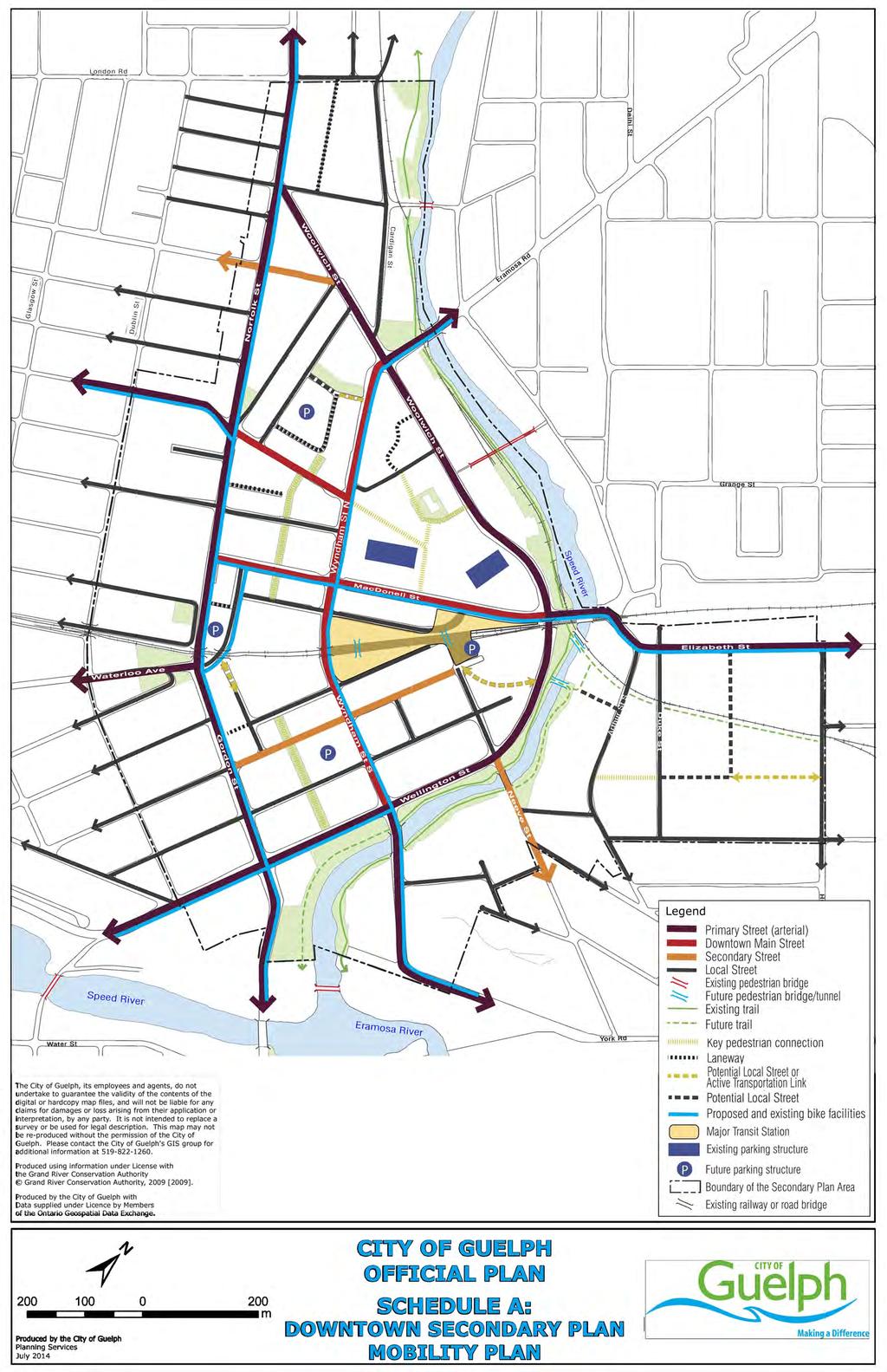
310
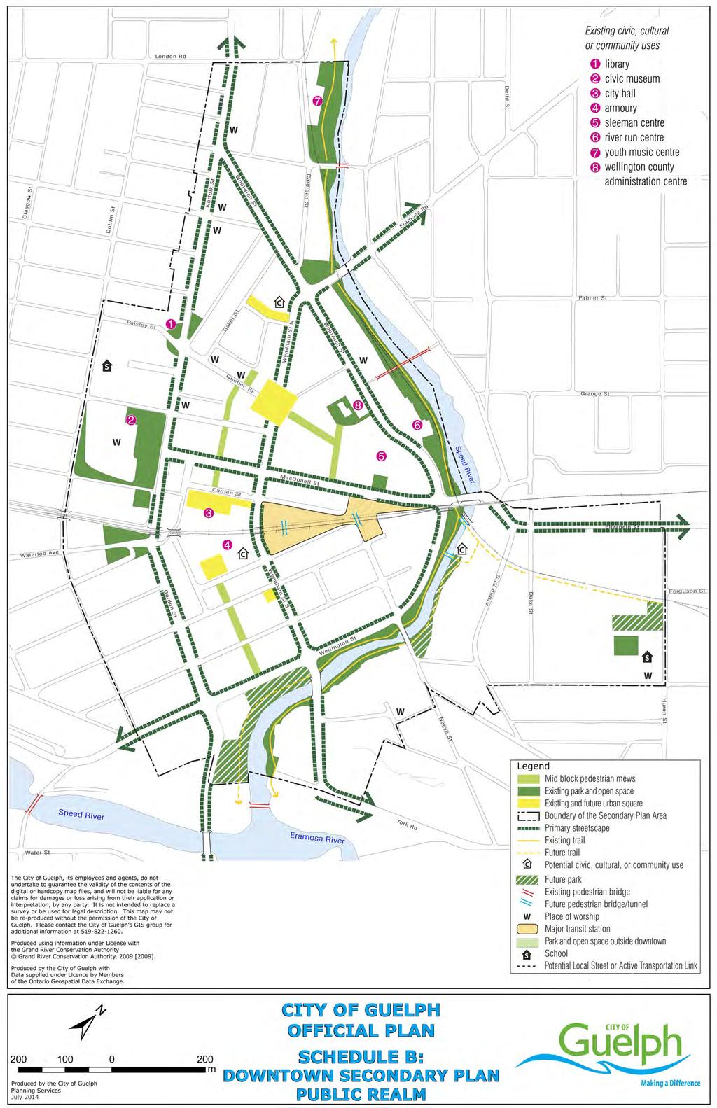
311
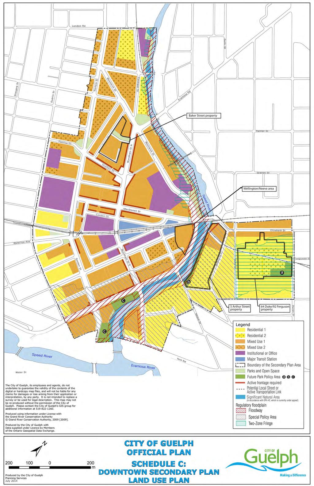
312
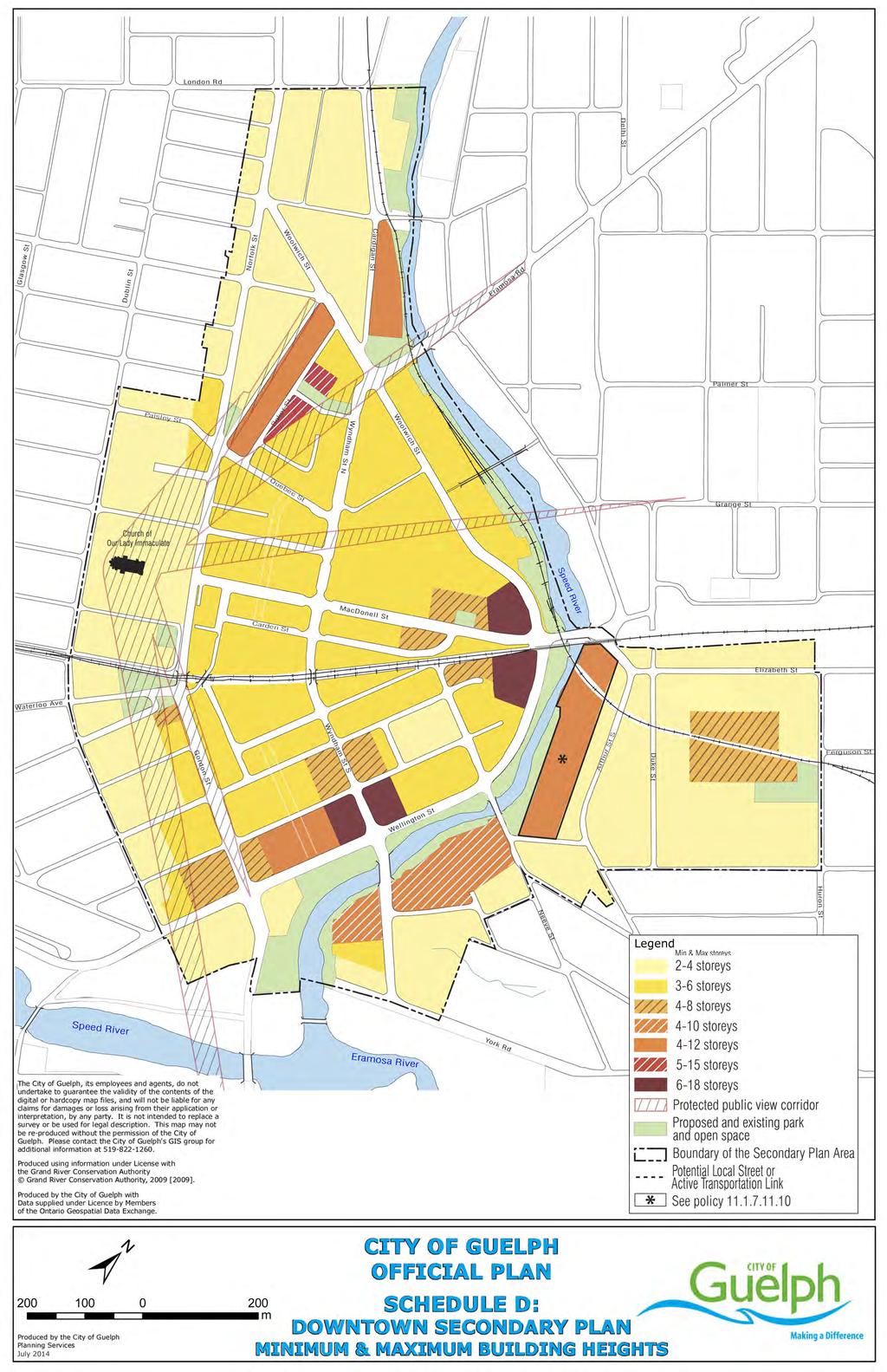
313


314 Appendix A: Built-Form Precedents High-quality cotemporary materials with architectural articulations of facades Mixed-use buildings with main entrance on a street Ground-floor residential units that support the animation of adjacent streets


315 Taller buildings with narrow floorplates that contribute to a varied skyline Appropriate urban transition between built form and trails Sensitive infill development within an historic context Low Impact Development measures integrated into an urban context
316 11.2 Guelph Innovation District Secondary Plan Introduction The Guelph Innovation District (GID) Secondary Plan establishes a detailed planning framework consisting of a Vision, Principles and Objectives and Policies and Schedules to guide and regulate future development of the GID Planning Area. Users of this Secondary Plan should refer to the comprehensive Official Plan for general city-wide policies applicable to the GID. The GID Planning Area comprises lands bounded by York Road to the north, Victoria Road South to the west and Watson Parkway South to the east and extending south to Stone Road East, also inclusive of lands south of, and immediately adjacent to, Stone Road East. City of Guelph Official Plan 304
317 Vision, Principles and Objectives A Vision for Guelph s Innovation District The Guelph Innovation District (GID) is a compact, mixed-use community that straddles the Eramosa River in the City s east end. The GID will serve predominately as the home of innovative, sustainable employment uses with an adjacent urban village connecting residential and compatible employment uses. The urban village is meant to be an identifiable, pedestrian oriented space, with street-related built form that supports a mix of medium and high density commercial, residential and employment uses. Important land use connections are also envisioned between the GID, as an innovation centre, the University of Guelph, as a knowledge-based research centre and the Downtown, as the City s civic hub and cultural centre, supporting the emergence of a University-Downtown-GID trinity of innovation spaces. The GID is at once highly energetic and intimately familiar, because it showcases an entirely new approach to planning, designing, and developing urban places, and at the same time, reflects Guelph s history and celebrates the rich heritage resources of the district, including the stunning river valley, dramatic topography and views, and historic Reformatory Complex. The GID is attractive, pedestrian-focused and human-scaled. It provides a mix of land uses at transit-supportive densities, offers meaningful places to live, work, shop, play and learn, and supports a wide range of employment and residential land uses. It protects valuable natural and cultural heritage resources while fully integrating them with the new community, features sustainable buildings and infrastructure, and works towards carbon neutrality. It makes needed connections between all modes of transportation, but in a manner that prioritizes pedestrians, cyclists and transit users over drivers, and stitches the GID into the overall fabric of the City. It is exciting and new and feels like it has been part of the City for a long time Principles and Objectives Principle 1: Protect what is Valuable Creating a place that respects the Natural Heritage System and cultural heritage resources, making citizens stewards of the resources for current and future generations. Objectives a) Preserve and enhance the extensive Natural Heritage System, including the Eramosa River Valley which is designated as a Canadian Heritage River. b) Respect the existing topography and sightlines, including public views and public vistas of the Eramosa River, Downtown and the historic Reformatory Complex. c) Ensure compatible public access opportunities to the Natural Heritage System and cultural heritage resources and promote their City of Guelph Official Plan 305
318 celebration, especially river vistas and edges, the Provincially Significant Earth Science Area of Natural and Scientific Interest (ANSI), and the historic Reformatory Complex. d) Connect surrounding land uses with the Natural Heritage System and cultural heritage resources and provide opportunities for compatible research, educational, recreational and urban agricultural uses. e) Ensure that significant built heritage resources and significant cultural heritage landscapes are conserved. Principle 2: Create Sustainable and Energy Efficient Infrastructure Building infrastructure that is efficient, focuses on renewable energy sources, and supports an integrated energy distribution system that enables a carbon free lifestyle. Objectives a) Create a framework for the GID to work toward carbon neutrality and exceed the City s Community Energy Plan targets, building infrastructure that is efficient that focuses on renewable energy systems, and supports an integrated distribution system that enables a carbon free lifestyle. b) Support development of an integrated energy distribution system, which maximizes connections between energy generation opportunities (producers) and end users (provides opportunities for local energy generation, maximizes connections between generation opportunities and end users, and minimizes overall energy use). c) Support processes where the waste by-products/surpluses of one activity are used as resources by another (e.g. industrial ecology). d) Include efficient, long-term and community based strategies to conserve and manage energy, water, wastewater, stormwater and solid waste. e) Develop a model community that showcases sustainable, green, low impact development. f) Embrace innovation, establish best practices, and serve as a learning environment for other communities across Guelph and Southern Ontario. g) Support the reduction of waste from construction debris as a result of the demolition of buildings by promoting and encouraging the adaptive reuse of existing building stock. Principle 3: Establish a Multi-modal Pedestrian-focused Mobility System Making connections that serve the community, allow current and future generations to walk or cycle to daily needs, and provide convenient transit services to access broader activities. Objectives a) Integrate the GID with the City as a whole, with clear connections to Downtown, the University of Guelph campus, and nearby neighbourhoods. City of Guelph Official Plan 306
319 b) Provide a transportation system (streets, sidewalks, cycle paths, trails, and rail) that serves the GID, provides rational and efficient connections for all modes of transportation, and provides compatible public access to the Natural Heritage System, where appropriate. c) Provide a land use pattern, urban design policies and standards and supportive transportation system that connect us with our daily needs, including transit stops, within a 5-10 minute walk of most residents. d) Provide a transportation system that is designed to prioritize pedestrians, cyclists and transit users over drivers by incorporating alternative development standards (e.g. larger right-of-ways for pedestrians and cyclists) and providing an extensive pedestrian and cycling network with direct, safe travel routes, and convenient, affordable transit service which is integrated with the rest of the City. e) Create and enhance connections for pedestrians, cyclists and potentially transit users across the Eramosa River Valley to better connect uses and activities. f) Integrate the current commercial rail line within the new community by including a potential transportation hub and commuting centre for the movement of people and goods. g) Ensure that the capacity of existing and new streets is sufficient to support the GID, while managing traffic impacts on adjacent road networks and neighbourhoods. Principle 4: Create an Attractive and Memorable Place Creating meaningful places to bring people, activities, environment(s) and ideas together, creating a sense of arrival and inclusion. Objectives a) Create a district of landmark quality with a strong and recognizable identity on par with the Downtown and the University of Guelph. b) Define gateways and community focal points on both sides of the Eramosa River to support the development of mixed-use areas that are safe, coherent, vibrant, and comfortable. c) Create a cohesive, efficient and vibrant transition area that will provide common supportive uses and built form to connect the urban village and employment area while still maintaining the unique function and identity of each area. d) Respect the southeast residential neighbourhood through the design and inclusion of an appropriate transition area between the residential uses and the industrial and major utility uses to the north. e) Define a block and parcel fabric that knits uses together and encourages new buildings to define the edges of streets, parks, trails and open spaces to provide a friendly face to encourage social interaction, safety, and a human scale. f) Create an accessible network of public facilities, parks, and open spaces which serves the new community and surrounding neighbourhoods, and is integrated with the Natural Heritage System and cultural heritage resources. City of Guelph Official Plan 307
320 g) Encourage high quality urban and architectural design that responds to and respects the GID s unique setting, natural and cultural heritage, edges and adjacent uses. h) Create a memorable landmark for the GID that establishes its identity, including potential connections to landmarks within the Downtown and the University of Guelph campus. i) Increase the overall tree canopy cover, and encourage the use of native species and edible landscapes, where appropriate, in restoration areas, parks, and open spaces and along streets throughout the new community. j) Respect (and emulate where appropriate) the Beaux-Arts design of the cultural heritage landscape component of the historic Reformatory Complex. Principle 5: Promote a Diversity of Land Uses and Densities Mixing it up to create vibrant, resilient, and efficient spaces that make it possible, practicable, and beneficial to reduce our ecological footprint. Objectives a) Create an integrated, compact, mixed-use district that provides an opportunity for people to live close to job opportunities and supportive daily services. b) Achieve transit-supportive densities with human-scaled built form. c) Establish a mix of land uses, building types and tenures in the new community, providing accessible choices for living, working, shopping, playing and learning. d) Promote mixed-use developments in appropriate locations that provide three or more significant uses, ideally in the same building, or if in separate buildings, within a walkable environment. e) Provide for a diverse cross section of residents with a mix of residential uses, building types and tenures in an urban village-type setting that is affordable, accessible and allows people to remain within the same neighbourhood as their needs change. f) Provide for a significant number and variety of jobs with a range of employment uses, building types, including those related to the development of a knowledge-based innovation cluster. g) Define a flexible block and parcel fabric that encourages evolution over time. h) Plan for a land use mix and densities which contribute to achieving the City s overall population, employment and density targets and the specific targets for the GID. Principle 6: Grow Innovative Employment Opportunities Grow innovative employment opportunities that support the knowledge-based innovation sector, within a compact, mixed-use community. Objectives a) Accommodate a significant share of Guelph s employment growth to City of Guelph Official Plan 308
321 b) Target the GID as a key area supporting the growth of a knowledgebased innovation cluster, which may include the agriculture, environment, information technology, advanced manufacturing, health and related science sectors, making connections to the Downtown and the University of Guelph campus. c) Nurture and capitalize on the GID as a recreational and tourist destination. d) Create a setting that reinforces the GID as a high density employment area that attracts provincially, nationally and/or internationally significant employment uses. e) Encourage employment uses within the historic Reformatory Complex that can showcase the site s cultural heritage resources. f) Support strategic and collaborative economic development partnerships within the GID, and local and regional community. g) Encourage a business environment by fostering learning and innovation within the GID. h) Encourage economic opportunities for the GID that contribute to innovative and sustainable employment uses that are compatible with a mixed-use environment, including residential uses. i) Support existing industrial uses, recognizing their contribution to the City s overall employment, waste management services, and carbon footprint reduction Natural and Cultural Heritage The natural and cultural heritage policies shape and regulate the conservation, protection and enhancement of the Natural Heritage System and cultural heritage resources found within the Guelph Innovation District (GID). The policies below are informed by the Vision and supporting Principles which seek to reflect Guelph s history and celebrate the rich heritage resources of the district, including the Eramosa River Valley, dramatic topography and views, and historic Reformatory Complex Natural Heritage 1. As identified on Schedule B, a significant portion of the GID is within the Natural Heritage System and is subject to the Natural Heritage System policies of the Official Plan. 2. The Natural Heritage System within the site area includes features such as the Eramosa River Valley that are important for their environmental and social values. The GID works in harmony with the Natural Heritage System which forms the basis of the Secondary Plan through its integration by the provision of natural breaks, transitional areas and scenic public views and public vistas within the site. 3. Roads and trails will be designed along the edge of the Eramosa River Valley to provide opportunities for a public edge, public views and greater protection opportunities. The Natural Heritage System shall City of Guelph Official Plan 309
322 be protected, maintained, restored and enhanced so that it may fill its role as the centerpiece of the GID. 4. The City will identify and support opportunities to provide greater public access to the Natural Heritage System including examining potential for an active transportation link located central to the site, providing a direct connection between the western development and the Reformatory Complex to the east and linking trail systems subject to an Environmental Assessment or EIS. 5. The City shall control access to the Natural Heritage System through wayfinding and signage along public trails to minimize impacts on flora and fauna. 6. The Provincially Significant Earth Science ANSI, shown on the Natural Heritage System Schedules of the Official Plan, within the GID presents opportunities for scientific and educational activities. These activities will be supported and showcased in conjunction with the adjacent trail network shown on Schedule A Cultural Heritage 1. Appendix A shows cultural heritage resources for illustrative purposes only, along with the Natural Heritage System as designated in the Official Plan to highlight the interconnections between the Natural Heritage System, cultural heritage resources and public views referred to in the Secondary Plan policies. Appendix A does not constitute part of the Secondary Plan policies. 2. As identified on Schedule B, the eastern portion of the GID is predominantly designated as Adaptive Re-use within a cultural heritage landscape with built heritage resources in the historic Reformatory Complex. Land uses within the cultural heritage landscape boundary are subject to the provisions of the Cultural Heritage Resource policies of the Official Plan. Policies related to the Adaptive Re-use land use designation can be found in Section of this Secondary Plan. 3. Development within the GID, on lands designated as Adaptive Re-use and/or adjacent to cultural heritage resources, should adopt an architectural vocabulary and design elements that are compatible with and respectful of the cultural heritage value and heritage attributes of the cultural heritage resources on site. 4. Cultural heritage resources including all features identified as provincially significant shall be conserved through long term protection mechanisms (e.g. heritage conservation easements). City of Guelph Official Plan 310
323 Topography 5. A Cultural Heritage Resource Impact Assessment and/or Conservation Plan will be required as part of a complete application to ensure that the cultural heritage resources within the site will be conserved. 6. All land uses within the GID are subject to the provisions of the Cultural Heritage Resource policies of the Official Plan. 7. It is the intent of this Secondary Plan to conserve cultural heritage landscapes, such as the area delineated as the historic Reformatory Complex on Appendix A that have been modified by human activities and are valued by the community. 8. Cultural heritage landscapes and visual relationships to built heritage resources shall be conserved and monitored to allow for meaningful interpretation. 9. Development will respect the existing cultural heritage resources and important public views and public vistas in site design. 10. The retention and integration of the Turfgrass Institute Building (G.M. Frost Centre) into the GID community is encouraged. 1. The topography associated with the Eramosa River Valley within the GID offers appealing vistas towards the historic Reformatory Complex as well as the Downtown, providing a distinctive character to the area. Future development shall take advantage of favourable topography and public views and public vistas and minimize the need for re-grading on site, where possible Urban Forest 1. The GID includes hedgerows, smaller wooded areas and individual trees that are part of the City s urban forest. Development and site alteration will identify opportunities for: a) Protection, enhancement, compensation and/or restoration of the urban forest; and b) Contributing to maintaining and increasing canopy cover in a manner that respects the cultural heritage landscape and associated public views and public vistas Energy, Servicing and Stormwater The energy, infrastructure and sustainability policies below contribute to the development of sustainable, green, low impact urban development within the GID. These policies are informed by the Vision and supporting Principles which seek to exceed Community Energy Plan targets, develop an integrated renewable and alternative energy generation and distribution system, and implement efficient, City of Guelph Official Plan 311
324 long-term, community-based strategies to conserve and manage energy, water, wastewater, stormwater and solid waste. These policies together with the mixeduse, active transportation and transit-oriented design policies for the GID will minimize the carbon footprint in the GID and increase the overall sustainability of development in the city General Policies Energy 1. Development in the GID shall contribute to the City s overall carbon reduction targets as set out in the climate change policies of the Official Plan and the City s Community Energy Plan. 2. The City will encourage decreased energy usage and emissions from transportation through the provision of infrastructure that encourages walking, cycling, use of public transit and the use of low-energy vehicles. Reductions in vehicular trips will also result through the mixed-use form of the GID which supports a live/work community. 1. Development within the GID shall be in accordance with the Energy Sustainability and Community Energy policies of the Official Plan and the following: a) All development in the GID shall have regard for the goals and strategies of the City s Community Energy Plan; b) Should the City, Guelph Hydro, and appropriate partners identify parts of the GID as potential district energy areas, new development shall be district energy ready subject to the City establishing District Energy Ready Guidelines; c) The City shall work with Guelph Hydro and appropriate partners on the development of a district energy system for the GID if such a system is feasible for the GID; and d) Where a district energy system has been established or is planned, new development will be encouraged and may be required to connect to the district energy system and new municipal buildings will connect to the district energy system. 2. Development in the GID will be encouraged to approach carbon neutrality in a cost-effective manner through gains in energy efficiency in built form and by sourcing additional needs from renewable energy sources such as wind, solar, and biomass energy. 3. Developers and owners of all new and existing buildings shall be encouraged to determine and label building energy performance subject to standards as may be adopted by the City. 4. Within the GID, a majority of the available roof area of new development will be encouraged to be dedicated to roof top solar technologies such as photovoltaic or solar thermal. City of Guelph Official Plan 312
325 5. Retrofits for achieving energy efficiency will only be undertaken to a built heritage resource where it is demonstrated that retrofitting can be accomplished without compromising the heritage integrity of the building Water and Wastewater Servicing Stormwater 1. Development within the GID shall be in accordance with the Water and Wastewater Systems policies of the Official Plan. 2. Development within the GID will implement water and wastewater master plans and the City of Guelph Water Conservation and Efficiency Strategy as updated from time-to-time. Given the importance of Innovation for the GID, development is encouraged to demonstrate water efficiency measures. 3. Industrial, Commercial and Institutional (ICI) development shall be encouraged to decrease water use through the reuse and/or substitution of water demands via greywater reuse or rainwater harvesting. Developers shall be required to demonstrate the efficient use of potable water with any development application. A target of 250 litres per day, per employee, is proposed for the new ICI development. 1. Development within the GID shall be in accordance with the watershed planning and water resources policies, and stormwater management policies of the Official Plan and the following: a) Low Impact Development (LID) measures intended to minimize stormwater run-off and recharge groundwater, including but not limited to rainwater harvesting and reuse systems, bio-swales or water features, infiltration facilities, permeable pavement and green roofs, shall be encouraged; and b) The City will explore opportunities to integrate LID measures into the public realm areas such as open space, amenity areas and right-of-ways, where feasible and appropriate. 2. Development within the GID shall address how pre-development standards may be achieved to maintain the hydrological cycle of the area under post development conditions. This will be achieved through the completion of a stormwater management assessment and/or analysis that includes, but is not limited to, the establishment of water quality, water quantity, water balance, erosion control and natural environment objectives and criteria. These analyses may be used in establishing stormwater management design requirements for development in the GID. City of Guelph Official Plan 313
326 Mobility The mobility policies strive to establish a multi-modal pedestrian-focused mobility system inclusive of an integrated network with roads, cycling facilities, sidewalks and paths designed, built and maintained with consideration for all users. The GID has been planned to encourage residents and employees to use active transportation and transit modes to support overall sustainability and carbon neutral objectives of this Secondary Plan. The mobility system must be comprised of: a network fully integrated with adjacent systems and destinations; sufficient transportation capacity within the network to absorb growth; and a long term plan for integration with the Guelph Junction Railway (GJR). The use of Transportation Demand Management (TDM) will assist the system in achieving the carbon neutral vision of the GID while offering an effective and efficient integrated transportation and recreational trail system General Mobility Policies 1. A legible network of public roads in a modified grid format will be established. This hierarchy of arterial, collector and local roads provide the general urban structure of the GID and the scale of future development blocks. 2. Wherever possible, public roads shall be aligned to respect the existing topography of the GID and minimize the need for site alteration. 3. All streets shall exhibit a high quality of streetscaping, landscaping, signage and amenities. 4. Consideration and provisions will be made for a future Active Transportation Link crossing over the Eramosa River as shown in Schedule A. If future development necessitates, controlled motorized vehicle access to this crossing may be considered for public transit. Any bridge crossing the Eramosa River will use the existing slopes and maintain, to the greatest extent possible, the topography of the Eramosa River Valley while ensuring that existing Natural Hazards are appropriately addressed and not further aggravated Transportation Demand Management (TDM) 1. All roads shall provide for the safe and efficient movement of people and goods. In areas planned for both high levels of truck traffic and high levels of pedestrian and cyclist activity, special attention will be paid to the design of the roadways to enhance pedestrian and cyclist safety and comfort (e.g. consolidated truck loading/unloading areas). Where necessary, traffic calming measures shall be incorporated into the street design of the local street network. 2. The City shall work with transit providers, developers and businesses within the University-Downtown-GID trinity area to develop and City of Guelph Official Plan 314
327 implement TDM measures that aim to reduce motorized vehicular trips and promote the use of active transportation modes, public transit, car-sharing and/or carpooling Active Transportation Walking and Cycling 1. Active Transportation Links identified on Schedule A are paths principally designed to provide a high level of service for Active Transportation as a component of the transportation network. Active Transportation Links connect cycling and transit systems enabling access to important destinations within and outside of the GID. 2. Active transportation shall be encouraged as a primary, safe, appealing and convenient mode of transportation to, from and within the GID. Pedestrian infrastructure shall be developed in accordance with the policies of the Official Plan. A cycling network shall be incorporated into both the street network and city-wide trail system. 3. An Active Transportation network shall ensure access and integration of all transportation modes within the network inclusive of: a) New pedestrian linkages to the river valley trail network, where feasible; b) Dedicated bicycle lanes on both sides of collector and arterial roads or separated bicycle facilities on one or both sides of arterial roads, where possible; and c) Bicycle rack and/or storage facilities conveniently located to facilitate access to a range of uses, transit stop locations and trail canoe launch and node locations. 4. Construction of cycling facilities, such as bicycle lanes, routes and/or cycle tracks shall align with the City s Cycling Master Plan guidelines for details regarding design standards Public Transit 1. Proposed Transit Stops are shown on Schedule A. To maximize accessibility and transit capture potential, the GID has been planned to have transit stops and amenities within a 5 to 10 minute walk of all development. 2. Public transit and its related infrastructure and amenities, including bicycle rack and/or bicycle storage facilities, shall form an integral component of the mobility network. 3. Where appropriate, special paving treatments including distinct visual and tactile materials are to be incorporated at Proposed Transit Stops. These raised, visually contrasting surfaces should clearly delineate pedestrian connections between street corners, street edges and transit stops. City of Guelph Official Plan 315
328 4. The future Active Transportation Link crossing the Eramosa River shall be designed to provide access to the Proposed Transit Stop along the existing GJR corridor The Road Network 1. The road network serving the GID shall generally be designed in accordance with the road classifications and alignments identified in Schedule A Arterial Roads 1. Arterial roads shall generally be designed and built in accordance with the standards outlined in Table 1 and the policies of the Official Plan. 2. Victoria Road South, York Road, Watson Parkway South and Stone Road East are arterial roads that provide access to and through the GID. 3. The City will improve York Road, Victoria Road South and Stone Road East according to relevant approved Environmental Assessments accommodating traffic generated by development of the GID. 4. Improvements to York Road will include an Environmental Assessment to determine the realignment of Clythe Creek Collector Roads Main Street 1. Collector roads shall generally be designed and built in accordance with the standards outlined in Table 1 and the policies of the Official Plan. 2. A new collector road (New Street A ) will provide a north-south link through the west side of the GID as shown on Schedule A and the following: d) North of College Avenue East this collector road shall provide the primary connection to the GID s residential community. This segment of the collector road shall intersect with local roads, with the number and location of intersections to be determined through the Block Planning process; and e) South of College Avenue East the collector road establishes the main spine for the GID s Employment Mixed-use 1 area. 1. A Main Street has been identified on the extension of College Avenue East into the site. The Main Street will function as a transition area City of Guelph Official Plan 316
329 Local Roads Parking between the lands designated Residential to the north and the Employment Mixed-Use 1 lands designated to the south. The Main Street area will accommodate a range of transportation options but should be considered a pedestrian and transit priority street and shall generally be designed and built in accordance with the standards outlined in Table 1 and in accordance with the Main Street policies of the Official Plan. 1. Local roads shall generally be designed and built in accordance with the standards outlined in Table 1 and the policies of the Official Plan. Local road alignments shall be determined through the Block Planning process. 2. An east-west local road (New Street B ) is shown on Schedule A to provide mid-block access between the College Avenue Extension and Stone Road East by connecting Victoria Road South with the GID s new north-south collector road (New Street A ). 3. A single loaded perimeter local road along the western edge of the Eramosa River Valley shall be considered to provide a public edge, opportunities for separated active transportation infrastructure, public view and public vista opportunities and greater protection opportunities of the Eramosa River Valley given single public ownership of the adjacent land. 4. Consideration shall be given to a potential connection from York Road to Dunlop Drive through the adaptive reuse area identified on Schedule B to increase public connectivity and access to the cultural heritage landscape and built heritage resources where appropriate and feasible. 5. A potential extension of New Street A south of Stone Road East as shown on Schedule A will be determined through the Block Planning process. 1. Wherever feasible, landowners are encouraged to enter into shared parking arrangements with adjacent uses and/or landowners. The shared parking approach takes advantage of different peak periods and reduces the overall additive peak hour use supply while also meeting the peak demands of individual uses. Occupancy Rates may be included as part of a shared parking table in the implementing Zoning By-Law and will be determined through the development approvals process. 2. The City may grant, on a site-by-site basis, suitable reductions in onsite parking requirements where off-site parking can be provided in City of Guelph Official Plan 317
330 proximity to principal building entrances, or car-share/carpooling, or transit pass arrangements are made, high levels of transit exist, or are planned, or affordable housing is proposed as per the parking policies of the Official Plan. A Parking Study and/or TDM Plan, prepared by a qualified professional, and provision of a binding parking lease agreement, shall be required by the municipality in order to evaluate and determine an appropriate reduction. 3. The provision of centralized shared parking opportunities will be considered as part of the Block Planning process. 4. Where parking is provided, priority spots for carpool vehicles, alternative energy vehicles (such as hybrids and electric cars), carshares, scooters and motorcycles shall be allocated. Such provisions shall be determined through site plan approval. 5. Parking areas for non-residential uses shall generally be located at the rear or side of buildings. All parking areas shall incorporate landscaping features to screen views of parking areas to the street. 6. The City may consider cash-in-lieu parking strategy as part of the implementing Zoning By-Law which shall consider the following: f) Cash-in-lieu options for mixed-use areas with large institutional anchors; g) Provision of underground, semi-underground or parking structures to facilitate shared parking demands; and h) Shared parking standards considering anticipated land use mix. City of Guelph Official Plan 318
331 Table 1: Public Street Classifications and Characteristics Street Type Arterial Roads Collector Roads Local Roads Main Street Other Street Names Victoria Road South, Stone Road East, York Road, College Avenue East New Street A New Street B All others Watson Parkway South Right-ofway widths 26 m to 36 m (As per OP) 26 m m 18 20m Planned setbacks Travel Lanes Proposed Transit Stops Parking Pedestrian Amenities Dedicated Bicycling Facilities Varies (Up to 3 m in Mixed-use Corridor areas) Victoria Road South, York Road, Stone Road East, Watson Parkway South Lane requirements defined by EA process Yes (Victoria Road South and New Street A; Victoria Road South and College Avenue East; Victoria Road South and New Street B; Victoria Road South and Stone Road East; New Street A and Stone Road East) None (Except as may be permitted in accordance with the Official Plan) Minimum 1.8 m sidewalks; 1.8 m planting, lighting and furnishing zone 3.0 m multi-use pathway on east side of Victoria Road South Min 1.8 m dedicated bicycle lanes, where possible. 3.0 m multi-use path on east side of Victoria Road South and bike lane on west side of Victoria Road South to be refined during detailed design Varies (1 m to 3 m for commercial displays and café seating) Varies (1 m to 3 m for commercial displays and café seating) 2 lanes 2 lanes (up to 4 lanes at peak hours) Yes (College Avenue East and Victoria Road South; College Avenue East and New Street A) Yes (both sides) Minimum 2.0 m sidewalks; 1.8 m planting, lighting and furnishing zone Min 1.5 m dedicated bicycle lanes Yes (College Avenue East and New Street A; New Street A and Victoria Road South; New Street A and Stone Road East) Yes Minimum 2.0 m sidewalks; 1.8 m planting, lighting and furnishing zone Min 1.5 m dedicated bicycle lanes Varies 2 lanes None Yes (where appropriate) 1.5 m sidewalks on both sides None City of Guelph Official Plan 319
332 The Public Realm The public realm policies shape and regulate two critical and inter-related elements: publicly owned spaces within the Guelph Innovation District (GID) (including all roads, sidewalks, and trails, parks and open spaces), and the relationship of the built environment (including all buildings and hard infrastructure) to these public spaces. Many of the components of the Vision and supporting Principles for the GID are related to and supported by these public realm policies, including: the creation of a pedestrian-focused and human-scaled environment; and the creation of a landmark quality community with defined gateways and focal points General Streets 1. In addition to the policies of this Section, the public realm within the GID is subject to the general Urban Design policies of the Official Plan. 1. Public streets are the backbone of a strong public realm. All streets will be designed to function as attractive and accessible public spaces in their own right. Road design will balance the provisions of a safe, accessible, functional and attractive pedestrian-oriented environment with an acceptable level of motor vehicle traffic and the movement of goods along arterial and collector roads. 2. In general, streets shall incorporate a high degree of landscaping within the public right-of-way allowance, inclusive of: landscaped boulevards separating sidewalks from traffic including on-street parking lanes. Where landscaped boulevards are not feasible, street trees shall be provided and their design and placement shall sustain a healthy urban tree canopy. 3. New tree rooting technologies should be used within higher density areas such as the Mixed-use Corridor (GID) areas. 4. Opportunities for landscaping within the public right-of-way will be explored and implemented as a means to increase the area s tree canopy and contribute to stormwater management. 5. The design and placement of street lighting and signage standards will be coordinated to establish a consistent and cohesive identity for the GID. Pedestrian scaled lighting should also be incorporated, where appropriate, into the design of lighting standards within the District. 6. Wherever possible, driveway access to parking areas will be shared between adjacent properties in order to maximize landscaping opportunities within medians; and to minimize the potential for City of Guelph Official Plan 320
333 pedestrian and vehicular conflict where driveways and sidewalks intersect. 7. In consultation with landowners, the City may seek to establish conveyances, or alternatively the creation of public easements, for the creation of appropriately sized mid-block pedestrian and bicyclist connections, interconnecting arterial, collector and local roads, the trail network and active transportation links. 8. The design and layout of the street network shall generally be consistent with Schedule A Parks, Public Open Spaces and Trail Networks 1. Development within the GID will include the creation of two new public park spaces, each with distinct roles and functions. The general location of new public parks are identified on Schedule B. City staff will secure and develop the new parkland through the development approvals process, making use of the provisions under the Planning Act to provide these park spaces over time. 2. The exact location and configuration of the new public parks will be determined through the development approvals process. 3. The public park spaces will be developed in accordance with the Open Space System: Trails and Parks policies of the Official Plan and the following specific policies: a) A new neighbourhood park will be developed in a central location within the designated Residential lands north of the identified Main Street; and will serve as a focal point for active and passive recreation. Frontage along a local road is preferred with strong active transportation linkages and facilities included within/adjacent to the park space to make connections to the trail system. b) A new community park that also includes neighbourhood park components will be developed within the designated Residential and/or Employment Mixed-use 1 lands south of the identified Main Street; and will serve as a focal point for active and passive recreation. Frontage along a collector road is preferred with strong active transportation linkages and facilities included within/adjacent to the park space to make connections to the trail system. 4. Buildings adjacent to park spaces will be designed to enliven and animate the edges of parks. Consideration shall be given to principal building entrances that front onto park spaces, where appropriate, while surface parking areas should not be situated flanking parks. 5. Parks and open spaces will support both active and passive activities. City of Guelph Official Plan 321
334 6. Subject to additional detailed design, park spaces shall incorporate a suitable balance of hard landscaped, soft landscaped and designated open and playground areas to accommodate a range of active, passive, programmed and aesthetic functions. 7. Parks and open spaces will be designed as community and cultural hubs accommodating programmed and non-programmed activities and reflect multi-generational and multi-use needs, providing spaces for both residential and employment populations. 8. Schedule A displays the existing and planned trail network. A trail network will be established for the GID, in accordance with the policies of the Official Plan, to serve as both a recreational and active transportation resource. The multi-purpose function of the trail system will support a carbon neutral vision and provide a public realm facility for messaging and celebrating the GID s natural and cultural heritage resources. 9. The City will increase the urban forest canopy coverage in parks and open space areas, where feasible and appropriate. 10. The City shall encourage linking parks and open space with the trail network and stormwater management facilities. 11. The City shall encourage and support community engagement opportunities through the design of parks and open space including community gardens, market opportunities, public art, etc. 12. Public art, along with interpretive signage, way-finding strategies and other techniques will serve as unifying elements for the GID. 13. The City shall encourage an integrated public art approach that ties together the natural and cultural significance of the District, with its future vision. The integration of public art in parks and open spaces shall be encouraged. Opportunities presented within the historic Reformatory Complex, trail network, parks and open space designations, and public lookout points and vistas should be considered as potential public art locations. 14. Public lookout points and vistas shall be accessible by multiple transportation modes Mixed-use Corridor Policies 1. Through implementation of the built form policies within this Secondary Plan (Section ), buildings within the mixed-use areas may be setback to preserve opportunities for the placement of small outdoor café and commercial display spaces. City of Guelph Official Plan 322
335 2. Commercial and mixed-use buildings will be encouraged to incorporate sheltering elements for the comfort and amenity of pedestrians Transit Stops Nodes 1. Transit Stops shall be designed to promote a sense of place and provide a high degree of user amenities which may include bicycle parking and/or bicycle storage facilities where appropriate. 2. Additional building setbacks and/or increased right-of-ways may be required through a draft plan of subdivision or site plan control for the provision of public benches, sheltered waiting areas, information displays, and landscaping treatments in the public right-of-way. 1. Nodes are identified at the intersection of collectors and arterial roads within the mixed-use designations in the GID and displayed on Schedule C. Nodes represent the confluence of many activities and uses. They are important gathering and meeting places, and the public realm should be designed to reflect their importance. 2. The design of buildings within and immediately adjacent to designated Nodes shall exhibit a high standard of architectural design. 3. The City will encourage and may require a high degree of transparency within the ground floors of all commercial and mixeduse buildings within the Nodes Land Use and Built Form The land use and built form policies shape and regulate the general pattern of development including permitted uses within the GID and the structuring of these uses within the built form (including building types, massing and height). The policies are informed by the Vision and supporting Principles General Land Use Policies 1. Schedule B establishes the pattern of land use within the GID. Where land use designations are the same as those in the Official Plan, the policies of the Official Plan shall apply. 2. Development within the GID will offer opportunities for people to live and work in close proximity which has the potential to reduce vehicular trips and the GID s overall carbon footprint. A balance of live and work opportunities that provide for day and night activities City of Guelph Official Plan 323
336 shall be encouraged to ensure a vibrant destination community where people can live, work, play and learn. 3. The GID will be developed to support and accommodate emerging innovation businesses and other green energy industries that will contribute to the emergence of the GID as an innovation centre together with the knowledge-based research centre located within the University of Guelph and with the civic hub and cultural centre of Downtown. Large tracts of undeveloped land, proximity to the University and Downtown, scenic viewsheds, the cultural heritage resources of the area and strategic marketing to attract new businesses will advance this third cluster within the University- Downtown-GID trinity. 4. The GID will be comprised of a mix of land uses, housing and building types at a sufficient density to support active transportation and transit. The GID will be defined by the public realm including roads, sidewalks, and parks, open spaces and trails as established by the policies and Schedules contained within this Secondary Plan. Employment, residential and commercial will be the predominant land uses to the west of the Eramosa River, with residential uses concentrated within neighbourhoods north and immediately south of College Avenue East. 5. Large-format, stand-alone retail commercial uses are not permitted within the GID. Small and medium-scale retail commercial uses are encouraged within the mixed-use designations of the site to contribute to a Main Street type environment. 6. In order to contribute to achieving the City-wide population and employment projections and density targets, the GID is planned to achieve the following by the year 2031: a) 8,650 jobs b) 6,650 people 7. Residential and employment lands within the greenfield area of the GID will be planned to contribute toward the overall density targets for the greenfield area of the City over the long term. The greenfield area of the GID will be planned and designed to achieve an overall minimum density target that is not less than 90 persons and jobs combined per hectare. 8. The topography, landscape and natural and cultural heritage features associated with the Eramosa River are unique to the GID within the City of Guelph. Future road alignment, siting and massing of buildings, and design of development should enhance scenic views of the Eramosa River valley and cultural heritage landscape features associated with the historic Reformatory Complex, as well as views of Downtown, by: City of Guelph Official Plan 324
337 a) Introducing a modified grid pattern of streets and designing future streets to respond to the natural open space and topographic conditions found on the site; b) Generally providing a single loaded local road on the table lands adjacent to the Natural Heritage System in the Mixed-use Employment area on the west side of the River to allow public access to views of the Eramosa River; c) Maintaining public views and vistas of the Eramosa River and cultural heritage landscape features from the Main Street area and residential areas to the north of College Avenue East; and d) Maintaining public views of the Church of our Lady Immaculate in Downtown. 9. The predominant character of built form within the GID will be established by mid-rise residential and employment buildings with a limited number of taller buildings at strategic locations marking the Nodes. A range of building types and uses are encouraged, including residential and mixed-use buildings, townhouses, research, design and office complexes, manufacturing and live/work units. 10. A series of nodes will be developed within the GID, as identified on Schedule C and according to policies contained within Section Higher density development within the site shall be organized at these nodes and associated transit stops. 11. Stormwater management facilities shall use land in a compact way, promote connectivity and be integrated within development as a component of the publicly accessible open space and park network by ensuring that: a) Fencing around ponds is minimized in favour of shallow slope grading adjacent to pooled areas; b) Where feasible, stormwater management facilities are integrated within connections between parks and natural heritage features; and c) Open spaces and/or public right-of-ways are provided adjacent to the perimeters of stormwater management ponds General Built Form and Site Development Policies 1. Development shall be planned and designed to: a) Consider future intensification opportunities within the site; b) Enhance connectivity by incorporating multi-modal transportation systems; c) Use sufficient block sizes in Residential and Mixed-use Corridor (GID) areas to achieve pedestrian-oriented development by generally establishing a maximum block length of meters measured along the long axis of a street; and City of Guelph Official Plan 325
338 d) Balance the needs of the businesses and residents through the use of public laneways, parking and open space within transitional areas. 2. Minimum and maximum building heights are indicated on Schedule C. It is planned that the tallest buildings will be located within nodes located at key intersections to provide focal points for the GID and within the southwest Residential area. Where heights have not been indicated on Schedule C, they will be established through the development approvals process. 3. Where public views and vistas are identified, heights lower than the maximum building heights on Schedule C may be established through the development approvals process to maintain public views and vistas of the Eramosa River and the Downtown. 4. Development will be of high quality architecture, landscape, and urban design and will make a significant contribution to creating a distinct character and identify for the residential and mixed-use neighbourhoods contained within the GID and will showcase the area s unique natural and cultural history. 5. Definition of street edge is a priority; development within the GID shall create a rhythm and spacing of building entrances and appropriately sized storefronts to encourage pedestrian activity. 6. Maximum building setbacks from the property line on public streets are included in Section , Table 1. Exceptions to setbacks established in Table 1 may be granted, through the development approvals process in the case of signature sites and public buildings that incorporate highly visible and accessible landscaped open space within the divergent setback. 7. In addition to other policies of this Secondary Plan, blocks, buildings and structures will be organized to define a public realm including public streets and laneways, driveways and sidewalks that contribute positively to the character and identity of neighbourhoods, including: a) Arranging blocks that maximize street frontage with buildings massed and articulated appropriately to minimize the scale of larger buildings and to add visual interest; b) Arranging blocks to maximize solar gain along the long axis while minimizing shadowing of adjacent properties and buildings; c) Providing visual overlook from new development to public spaces and including building entrances, active ground floor frontages and transparent building materials along the edge of public space; City of Guelph Official Plan 326
339 d) Ensuring main building entrances are directly accessible from a public street, or a publicly-accessible courtyard physically and visually connected to the street; e) Minimizing impacts on vehicular, bike and pedestrian traffic on Arterial and Collector streets by providing vehicular access, ramps, servicing and loading access from local streets or laneways whenever possible and minimizing the number of driveway access points; f) Providing vehicular access from rear laneways to detached, semi-detached and duplex houses, townhouses and live/work units to reduce the number of curb cuts and protect opportunities for soft landscaping and active uses at grade along street edges; g) Defining transitional areas between uses in development blocks through provision of landscaped courtyards and other outdoor amenity space; h) Visually enhancing surrounding public streets, parks and other public spaces through landscaped open space; i) Designing sites, buildings and landscaping to encourage informal surveillance through strategies such as: clear sightlines into building entrances, parking areas, amenity spaces and site servicing areas; locating open spaces adjacent to public roads to improve the safety of parks through passive surveillance; providing low growing plant material along pedestrian walkways; and providing pedestrian-scale lighting in areas of pedestrian activity; and j) Providing traffic calming features, including but not limited to, curb extensions, raised surface treatments, chicanes, and textured paving. 8. The GID shall be designed to accommodate the needs of persons with disabilities. Urban design considerations for a barrier-free environment should meet the Accessible Design policies of the Official Plan, at minimum, addressing the following: a) Pathways free of obstructions, including street furniture, signs, trees, shop awnings and advertising signs, etc. Obstructions should be placed outside the path of travel wherever possible; b) Signage that is clear, glare-free, simple, easy to read and understand, and properly lit at night. The colour of signs should contrast with the surrounding surface, and the colour combinations red/green and yellow/blue should not be used to avoid confusing colour-blind persons; c) Provide tactile cues such as guide strips to help a person with sight problems identify travel routes. Guide strips should be laid in a simple and logical manner, and should have a contrasting colour with the surrounding surface. The strips should be flush with the road surface so as not to hinder people with mobility problems; and d) Outdoor accessible parking spaces should be located near accessible building entrances. Indoor accessible parking spaces City of Guelph Official Plan 327
340 should be located near accessible elevators, or as close as possible to exits. 9. To ensure an attractive streetscape and maximize opportunities for passive energy efficiency/carbon neutrality, architectural controls may be required to be developed through the Block Plan process to address detailed building design aspects such as: massing; passive energy efficiency matters; siting; grading; elevation articulation; garage articulation; materials colour, sustainability and quality; and roof design. 10. Residential dwellings shall be designed such that garages are not the dominant feature in the streetscape. Garages for all ground-related dwellings shall generally be in the rear yard accessed by laneway or front driveway. This will allow for: Land Use Designations a) Ground floor front porches, windows and front facing rooms to create a more attractive housing form and to enhance neighbourhood safety through casual surveillance; b) The creation of an attractive streetscape; c) Adequate space for street trees and front yard landscaping; and d) Additional opportunities for on-street parking in front of the units Adaptive Re-use (GID) 1. The Adaptive Re-use area is designated on Schedule B. The Adaptive Re-use designation includes provincially significant cultural heritage resources where the conservation, rehabilitation, restoration, maintenance and re-use of built heritage resources and cultural heritage landscapes will serve as the focal point of new development. This designation permits a mix of uses including institutional, educational, commercial, office, light industrial and open space and park in a form that respects the existing built heritage form, cultural heritage landscape features, as well as the relationships between cultural heritage resources considered for adaptive reuse and redevelopment. 2. Development shall be physically and visually compatible with and respectful of the cultural heritage value and heritage attributes of the cultural heritage resources on site. New additions or new construction to a built heritage resource, where permitted to facilitate adaptive reuse, shall conserve the cultural heritage value and heritage attributes. 3. Through the Block Plan process and/or the development approvals process, the mix of uses, zoning categories and City of Guelph Official Plan 328
341 Mixed-use Corridor (GID) appropriate regulations will be established to permit and control uses within the Adaptive Re-use designation. 1. Mixed-use Corridor (GID) areas are designated on Schedule B and include areas comprised primarily of vacant or under-used lands that are targeted for significant growth. These areas will consist of a mix of residential, commercial, live/work, institutional, office and educational uses within a highly compact form of development that will contribute to the creation of focal points and transition areas. High quality urban and architectural design and a well-connected, pedestrian-oriented, public realm in accordance with the policies of this Section and Section of this Secondary Plan will define these areas. 2. The following uses may be permitted within the Mixed-use Corridor (GID) designation: a) Commercial, retail and service uses; b) Office; c) Entertainment and recreational commercial uses; d) Cultural and educational uses; e) Institutional uses; f) Hotels; g) Live/work; and h) Medium and high density multiple unit residential buildings and apartments. 3. A consistent built form edge shall be established through maximum setbacks established in the implementing Zoning Bylaw in accordance with Table Development within the nodes identified on Schedule C and along College Avenue East within the identified Main Street area will be compact and mixed-use with a continuous built form edge containing the following: a) Retail and service uses, including restaurants and personal service uses, entertainment uses or professional offices and community or social services shall generally be required on the ground floors of all buildings at the street edge; b) Building façades facing a public street shall be considered a primary façade. A minimum of one pedestrian entrance shall be provided for any primary façade; c) Buildings on corner lots should be designed to have primary façades on both the front and side street; d) Ground floor heights will generally be a minimum of approximately 4.5 metres floor to floor; windows shall City of Guelph Official Plan 329
342 correspond appropriately to the height of ground floors. Generally, a large proportion of the street-facing ground floor wall of new mixed-use buildings shall be glazed; and e) Building heights shall contribute to a continuous street wall that has a minimum height of 4 storeys as shown on Schedule C. 5. The GID will be anchored by a mixed-use urban village at the intersection of the eastern extension of College Avenue East and an interior north-south collector that will offer a wide range of urban amenities and services. A signature site will be located at the intersection of College Avenue East and the proposed northsouth Collector. A landmark building of high quality urban design and architectural detail located within the signature site will provide an anchor to the urban village. At grade, pedestrian-oriented, commercial amenities will be provided. 6. The following shall apply to all development located within the Mixed-use Corridor (GID) designation: a) Buildings with long façades shall be designed with architectural articulation and changes in material to create interesting building forms, compatible development which breaks up the visual impact of the massing. Articulated massing may include: building stepping/façade stepbacks, layered massing (horizontal or vertical) and modulation and change in materials and colour; b) The massing and articulation of buildings taller than five storeys shall provide appropriate transitions to areas with lower permitted heights, minimizing impact on the street level as well as shadow impacts. A step-back of generally 3m-6m minimum is required above the sixth storey. The floorplates of floors above the eighth storey generally shall be a maximum of 1000 square metres; and c) All buildings should be finished with high quality, enduring materials, such as stone, brick and glass. 7. For free-standing residential development, the maximum net density is 150 units per hectare and the minimum net density is 100 units per hectare Employment Mixed-use 1 1. The Employment Mixed-use 1 designation on Schedule B includes areas targeted for significant growth as a landmark area in the University-Downtown-GID trinity. These areas will permit a mix of uses focusing on higher density, innovation and sustainability which includes uses such as research and development, commercial, educational, and entertainment uses City of Guelph Official Plan 330
343 that will serve to support the role of the business area as a knowledge-based innovation centre. 2. The following uses may be permitted within the Employment Mixed-use 1 designation: a) Office and administrative facilities; b) Research and development facilities; c) Hotel and convention facilities; d) Entertainment and recreational commercial uses; e) Assembly and manufacturing of product lines requiring ongoing research and development support; f) Associated ancillary retail uses that are an integral component of the primary uses; and g) Complementary or accessory uses may also be permitted. Such uses may include restaurants, financial institutions, medical services, fitness centres, open space and recreation facilities and child care centres. 3. Low density employment uses such as logistics and warehousing are not permitted. 4. Where land use transitions from Residential and/or Mixed-use Corridor (GID) to Employment Mixed-use 1 areas, the following uses shall be priorities to ensure a compatible mix of uses: offices and entertainment and recreational commercial. 5. Development in the Employment Mixed-use 1 designation will comprise a mix of street-related and campus form development. Campus form development is to consist primarily of prestige employment/research park uses and is to be concentrated within Block Plan Area 2 with higher density encouraged to locate along Victoria Road South and Stone Road East. 6. Campus form development in the employment area is appropriate near open space and natural heritage elements (Eramosa River Valley) where a balance of site and building design can integrate landscape, topography, and other special features with site access requirements including roads, driveways, parking, and service and loading areas. Campus form development shall comply with the following: a) Buildings should be oriented to maximize open space opportunities, providing a scale and pattern of development that supports pedestrian activities at grade between buildings while maximising solar gain; and b) Where appropriate, building heights and massing should optimize views at-grade to the open space and natural heritage elements. City of Guelph Official Plan 331
344 7. Street related design consists of buildings that define street edges through established maximum setbacks and consistent landscape edge treatment and include: a) Maximum setbacks as established in Table 1; and b) Active at-grade uses with street access which could include retail, cafes and restaurants to connect public activity within the building, street and open space. 8. Through the Block Plan process and/or the development approvals process, zoning categories and appropriate regulations will be established to permit and control uses within the Employment Mixed-use 1 designation including locations for street edge and campus form development Employment Mixed-use 2 1. Employment Mixed-use 2 areas are designated on Schedule B. These areas will have a mix of uses including: office, commercial, educational and institutional, and, to a lesser extent, entertainment uses that will serve to support the role of the employment area as an important component of the Guelph Agri-Innovation Cluster. 2. The following uses may be permitted within the Employment Mixed-use 2 designation subject to the applicable provisions of this Secondary Plan: a) Research and development facilities; b) Office and administrative facilities; c) Cultural and education uses; d) Institutional uses; e) Entertainment and recreational commercial uses; f) Associated ancillary retail uses that are an integral component of the primary uses; and g) Complementary or accessory uses may be permitted. Such uses may include convenience commercial uses and community facility uses. 3. The following uses are not permitted within the Employment Mixed-use 2 designation: a) Residential; b) Live/work; and c) Logistics and warehousing. 4. The areas designated Employment Mixed-use 2 adjacent to Stone Road East between the Eramosa River and Watson Parkway South will serve as a transitional area to buffer the residential lands south of Stone Road East from the Major Utility City of Guelph Official Plan 332
345 Residential and Industrial designated lands north of Stone Road East. Within the Employment Mixed-use 2 designation the following shall apply: a) Buildings will be oriented towards Stone Road East with sufficient front setbacks with landscaped open space; b) Heights that provide sufficient screening of industrial uses from residential development south of Stone Road East will be established within the implementing Zoning Bylaw; and c) Parking, loading and access will comply with policies established in this Secondary Plan and the general urban design policies of the Official Plan. 5. Through the Block Plan process and/or the development approvals process, zoning categories and appropriate regulations will be established to permit and control uses within the Employment Mixed-use 2 designation. 1. Residential areas are designated on Schedule B. The predominant land use in this designation shall be medium density housing forms such as townhouses and apartments with a limited supply of low density housing forms such as single and semi-detached dwellings. The final range and distribution of these housing forms will be determined through the Block Plan and/or development approvals process and regulated through the implementing Zoning By-Law. 2. The following uses may be permitted within the Residential designation: a) Multiple unit residential buildings, such as townhouses and apartments; b) Detached, semi-detached and duplex dwellings; c) Convenience commercial uses limited to a maximum gross floor area of 400 square metres on a property; d) Live/work units; e) Community services and facilities; f) Child care centres; g) Schools; and h) Park space including urban squares. 3. Multiple unit residential buildings and live/work units shall be oriented towards a street with the main entrance to the building/dwelling unit accessible directly from a right-of-way. City of Guelph Official Plan 333
346 4. The layout of local roads within residential areas shall consider orientation that facilitates maximum solar gain along the long axis of buildings. 5. The maximum net density is 150 units per hectare and not less than a minimum net density of 35 units per hectare. Minimum and maximum heights are indicated on Schedule C Glenholme Estate Residential The Glenholme Estate Residential area is designated on Schedule B. This designation includes lands containing existing low density estate residential uses on large lots that are currently serviced by private individual on-site water and wastewater services. Due to the unique characteristics of the area, it is anticipated that the existing residential uses will continue in their current form during the Secondary Plan period, with opportunities for minor limited additional estate residential infill development which is consistent with the character of existing development. Existing and new development within this land use designation are subject to the following policies: 1. Notwithstanding any other provision of this Secondary Plan, only the following uses shall be permitted: a) Single detached dwelling; b) Accessory apartment; and c) Home occupation. 2. Limited additional low density estate residential infill development may be permitted on existing lots that are 1.0 hectare in size or greater, subject to meeting the following size criteria, and all other applicable policies of this Secondary Plan: a) Minimum lot size of 0.4 hectare for new and retained residential lots and an average lot size (of new lots and retained residential lots) of 0.7 ha. 3. New residential lots shall be configured and sized to maintain the character of the lot fabric of the area including frontage, setbacks, landscaped space and amenity areas and to ensure flexibility for the proper ongoing operation of private individual on-site services. 4. Notwithstanding the servicing policies of the Official Plan, new estate residential development within the Glenholme Estate Residential designation may be permitted with private individual on-site water and wastewater services as an interim measure until full municipal services are available. City of Guelph Official Plan 334
347 5. As part of a development application the City may impose such conditions as are deemed appropriate to protect City and public interest, particularly with respect to protecting City drinking water supplies. The City may require proponents to enter into an agreement related to the ongoing operation and maintenance of interim private services, the requirement for the property owner to connect to full municipal services when they become available at their own expense, and other relevant matters. 6. Development within the Glenholme Estate Residential designation will be regulated through a site specific Zoning Bylaw amendment and shall be subject to site plan control. 7. Notwithstanding the policies of this plan pertaining to woodlands, for the properties at 745 Stone Road East and 58 Glenholme Drive, where a woodland has been identified through an EIS, the assessment of the potential to allow development shall be undertaken in accordance with the policies of Section 6.8, including any associated definitions, of the 2001 City of Guelph Official Plan, in effect as of May 12, Open Space and Parks 1. Open Space and Parks areas are designated on Schedule B and are subject to the Open Space and Parks policies of the Official Plan and the applicable provisions of the GID Secondary Plan. 2. In accordance with the policies of the Official Plan, municipal parks and municipal recreation facilities are permitted in all land use designations Neighbourhood Commercial Centre 1. As identified on Schedule B, a small portion of the GID, located at the southeast corner of York Road and Victoria Road South, is designated as Neighbourhood Commercial Centre and is subject to the Neighbourhood Commercial Centre policies of the Official Plan Service Commercial 1. As identified on Schedule B, a small portion of the GID, located at the southwest corner of York Road and Watson Parkway South, is designated as Service Commercial and is subject to the Service Commercial policies of the Official Plan. City of Guelph Official Plan 335
348 Industrial Major Utility 1. As identified on Schedule B, portions of the GID are designated as Industrial and are subject to the Industrial policies of the Official Plan. 1. As identified on Schedule B, a significant portion of the east side of the GID is designated Major Utility and is subject to the Major Utility policies of the Official Plan Compatibility: Major Utility and Industrial Uses 1. When considering development applications and public realm projects, there shall be regard to all applicable provincial and municipal policies, regulations and guidelines to ensure that compatibility will be achieved and maintained with regard to noise, vibration, dust, odour, air quality and illumination so as to achieve the goals of: a) Preventing undue adverse impacts from proposed development on the City s Waste Resource Innovation Centre, designated Major Utility and the Cargill plant designated Industrial; and b) Preventing undue adverse impacts on the proposed development from the City s Waste Resource Innovation Centre, designated Major Utility and the Cargill plant designated Industrial. 2. Sensitive land uses may be prohibited in the Zoning By-law or limited (through massing and siting, buffering and design mitigation measures) in areas in proximity to the Major Utility and Industrial designations to ensure compatibility. In addition, noise and air emissions reports shall be required and vibration and illumination reports may be required, in support of development approval requests. Such environmental reports are to specify how compatibility will be achieved and maintained between the Waste Resource Innovation Centre and Cargill and the proposed development, and may include measures aimed at minimizing impacts. 3. The City shall consult with the Ministry of the Environment, Cargill and the City s Waste Resource Innovation Centre during the development approvals process and during the design process for public spaces in the vicinity of the Cargill plant and the City s Waste Resource Innovation Centre property to ensure compatibility Interpretation and Implementation The implementation of this Secondary Plan will require a variety of tools and many actions on the part of the City, private landowners, institutions and others. This City of Guelph Official Plan 336
349 Section describes important tools and strategies to be used by the City in addition to the tools and strategies identified in the Official Plan. It also identifies initiatives and partnerships intended to implement key elements of this Secondary Plan and, in the process, encourage private development and investment in the GID. Many of the strategies build upon previous initiatives and current investments by the City Interpretation and Implementation Policies 1. Lands within the GID Secondary Plan area are subject to the interpretation and implementation policies of the Official Plan and the following specific policies. 2. Where the policies of this Secondary Plan conflict with those in the Official Plan, the policies of the GID Secondary Plan shall prevail. 3. The built form policies of the GID Secondary Plan respond sensitively to the topography and adjacent land uses. The primary intent is to ensure compatibility among buildings of different types and forms, the minimization and mitigation of adverse shadow and view impacts, and the creation and maintenance of an inviting and comfortable public realm. Nevertheless, the City recognizes the need to be somewhat flexible and allow for well-designed buildings that respond appropriately to the conditions of their site and surroundings and are consistent with the principles of this Secondary Plan. Where generally is used to qualify a built form policy found in Section of this Secondary Plan, it is the intent that the policy requirement shall be met except where an applicant has demonstrated to the City s satisfaction that site-specific conditions warrant considerations of alternatives, and that the proposed alternative built form parameters meet the general intent of the policy. Such exceptions shall not require an amendment to this Secondary Plan Design Review 1. The City may establish a design review committee, comprised of professionals with expertise in planning and urban design, architecture, engineering, landscape architecture and/or environmental design, or other advisory process, such as an architectural or urban design peer review process at the applicant s expense, to assist in the review of significant development proposals and capital projects in the GID. In reviewing significant development projects within the GID, such a committee or process shall be guided by the policies of the GID Secondary Plan and applicable Official Plan policies and shall consider the urban design, architectural, engineering, landscape and environmental design aspects of the proposal. City of Guelph Official Plan 337
350 Block Plans 1. Block Plan areas are identified on Schedule D. These areas have been delineated based on existing boundaries such as roads and the Eramosa River, land ownership patterns and land use designations. 2. Block Plans will be developed for each of the identified Block Plan areas to specifically implement the policies of the GID Secondary Plan. The Block Plan process will establish a pattern of development which ensures that development will occur in an orderly, cost effective and timely manner. Actual timing of development will be managed through the City s annual Development Priorities Plan in accordance with the managing growth policies of the Official Plan. 3. The Block Plan areas will be used for the purposes of monitoring and ensuring achievement of population, employment and density targets as well as capital programming and land assembly. The minimum targets for the Block Plan areas are established in Table 2: Table 2: Block Plan Area Targets Population Target Employment Target Residential Density (units/net ha) Employment Density (jobs/net ha) Block Plan Area 1: 4,600 1, Block Plan Area 2: N/A 2,500 N/A 90 Block Plan Area 3: 2,000 1, Block Plan Area 4: N/A 750 N/A N/A 4. Block Plans are required to be developed to the satisfaction of the City and approved by the City for each of the identified Block Plan areas prior to approval of any development application within the corresponding Block Plan area. 5. Block Plans will be prepared in accordance with a Terms of Reference approved by the City. Block Plans will demonstrate conformity with the policies and schedules of the GID Secondary Plan and will include, but not necessarily be limited to, the following: City of Guelph Official Plan 338
351 a) Road pattern (including location of new public and/or private streets and laneways and alternative street cross-sections where required); b) Layout of development blocks and stormwater management ponds and facilities; c) Location, size and configuration of parks, open space and urban squares; d) Density and distribution of housing types; e) Architectural design controls; f) Achievement of the population, employment and density targets established in Table 2; g) Provision of municipal services; h) Refinement of trail network and active transportation links; i) River crossings (need and feasibility analysis); j) General location of public views and vistas; k) Evaluation of cultural heritage resources and methods of conservation; l) Conformity with the built form and site development policies of the GID Secondary Plan and the urban design policies of the Official Plan through the development of design guidelines for the area; and m) Conformity with the energy policies of the GID Secondary Plan including the Implementation Strategy for the GID that coordinates and manages the implementation of the policy directions related to the achievement of carbon neutral development. 6. Draft plan of subdivision, Zoning By-law amendment and site plan applications, or any phases thereof, for properties subject to Block Plans shall demonstrate to the City s satisfaction that the proposed development is generally consistent with the applicable Block Plan and will contribute to meeting the principles, objectives and applicable policies and targets of the GID Secondary Plan. Block Plans may be amended through the development approvals process, provided the relevant policies of the GID Secondary Plan continue to be satisfied. 7. A traffic impact study will be prepared to the satisfaction of the City in accordance with a Terms of Reference approved by the City as part of the Block Plan process. 8. An Environmental Impact Study will be prepared in accordance with a Terms of Reference approved by the City as part of the Block Plan process and will meet the Environmental Study Requirements of the City s Official Plan to the satisfaction of the City in consultation with the GRCA. 9. The EIS will include the enhancement and restoration of existing surface water features and their riparian areas in order to support fish habitat and the improvement of water quality and quantity. City of Guelph Official Plan 339
352 10. The EIS will establish management objectives and stewardship and/or restoration recommendations for the respective block plan areas for the City s Natural Heritage System that is within the GID. 11. The City may require the preparation of detailed Environmental Impact Studies in support of development applications. The need for additional environmental studies will be determined through the preconsultation process prior to the submission of development applications Height and Density Bonusing 1. Development may be permitted additional height and density to a maximum of two additional storeys above the maximum building heights identified on Schedule C, in accordance with the Height and Density Bonus Provision policies of the Official Plan, for the following: a) Development within the Mixed-use Corridor (GID) designation; and b) Development within the Employment Mixed-use 1 designation along Victoria Road South and Stone Road East. 2. In addition to the community benefits outlined in the Official Plan, design elements that significantly contribute to the achievement of carbon neutrality shall be considered community benefits when the City considers authorizing increases in height and density within the identified nodes in the GID Special Studies and Future Initiatives 1. The City will prepare an Implementation Strategy for the GID to coordinate and manage the implementation of the policy directions related to the achievement of carbon neutral development. The Implementation Strategy will identify targets for carbon neutrality and describe a range of mechanisms, tools and initiatives that may be used by the City, landowners and developers to achieve the identified targets. The GID Implementation Strategy shall be incorporated into and refined through the Block Plan process. 2. Alternative development standards may be developed where appropriate to meet the objectives and policies of this Secondary Plan. 3. Additional studies may be required prior to or as part of Block Plan approval to implement development within the GID. These studies include but are not limited to the following: City of Guelph Official Plan 340
353 Finance a) A stormwater management assessment and/or analysis that includes, but is not limited to, the establishment of water quality, water quantity, water balance, erosion control and natural environment objectives and criteria. These analyses may be used in establishing stormwater management design requirements for development in the GID; b) A Water and Wastewater Master Plan that establishes conceptual design and development standards for development in the GID; and c) A District Energy Feasibility Study with Guelph Hydro and landowners to guide implementation and development of a District Energy System in the GID. 1. The implementation of the policies of the GID Secondary Plan will be subject to the capital budget and financial policies and procedures approved by City Council, as well as the availability of funding or service provision from other levels of government Partnerships Definitions 1. The City will work in partnership with the Province and other stakeholders towards the effective and efficient development of lands in accordance with the policies of this Secondary Plan, including assessing the following: a) Site/servicing development models for priority areas including the extension of College Avenue East; b) Development of Research and Development Clusters in partnership with the Post-Secondary Institutions; c) Redevelopment of the Guelph Correctional Facility for uses permitted by the Adaptive Re-use designation, including assessing the feasibility for the possible extension of College Avenue East over the Eramosa River to provide pedestrian and transit connections to such development; and d) Coordination of marketing and business development efforts targeting knowledge-based innovation sector businesses and other related users within mixed-use employment areas. 1. In addition to definitions of the Official Plan, the following definitions are applicable in the Guelph Innovation District Secondary Plan: Active Transportation means: Modes of transportation, such as walking and cycling that: provide the personal benefits of fitness and recreation; are environmentally friendly; contribute to the personal and social health of neighbourhoods; and are readily available to a wide range of age groups within the community. City of Guelph Official Plan 341
354 Adaptive Reuse means: The alteration of built heritage resources to fit new uses or circumstances while retaining their heritage value and attributes. Available Roof Area means: The total roof area minus the area for mechanical equipment, roof top terraces and perimeter access restrictions. Carbon Neutral means: For the purpose of the GID, carbon neutrality refers to the indirect and direct carbon emissions emitted from the new buildings that will be developed within the GID boundary. Net zero carbon emissions will be achieved by balancing the annual amount of carbon released (by burning fossil fuels) with the equivalent amount that is sequestered and/or offset from on-site or off-site renewable energy. The carbon emissions associated with transportation, waste, water and food generation/production will be addressed and reduced as a result of the complete community design of the GID. That said, these related emissions will not be included in the carbon neutral definition for the GID. Compatibility means: Development or redevelopment which may not necessarily be the same as, or similar to, the existing development, but can co-exist with the surrounding area without unacceptable adverse impact. District Energy means: A system that ties together distributed thermal energy generation and users through a local supply loop. Guelph Agri-Innovation Cluster means: The Guelph Agri-Innovation Cluster consists of two main subsectors, food and wellness and agri-business, which afford many niche opportunities for value creation that align strongly with the infrastructural strengths of the region. The report Strategic Plan for the Guelph Agri-Innovation Cluster, dated March 3, 2010, completed by Hickling Arthur Low and Urban Strategies Inc. further defines the Guelph Agri-Innovation Cluster. Public Realm means: Public spaces such as public streets and rights of way, urban squares, parks, community trails, and open spaces. Public View means: A view toward important public and historic buildings, natural heritage and open space features, landmarks and skylines when viewed from the public realm. City of Guelph Official Plan 342
355 Public Vista means: Views that are framed through built form or between rows of trees when viewed from the public realm. Redevelopment means: The creation of new units, uses or lots on previously developed land in existing communities, including brownfield and greyfield sites. City of Guelph Official Plan 343
356 Schedules Schedule A Schedule B Schedule C Schedule D Appendix A Mobility Plan Land Use Built Form Elements Block Plan Areas Heritage City of Guelph Official Plan 344
357
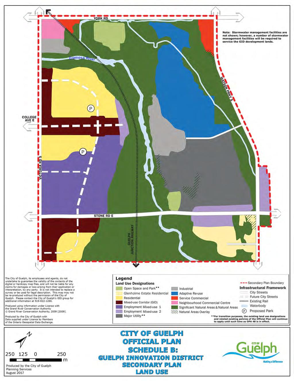
358
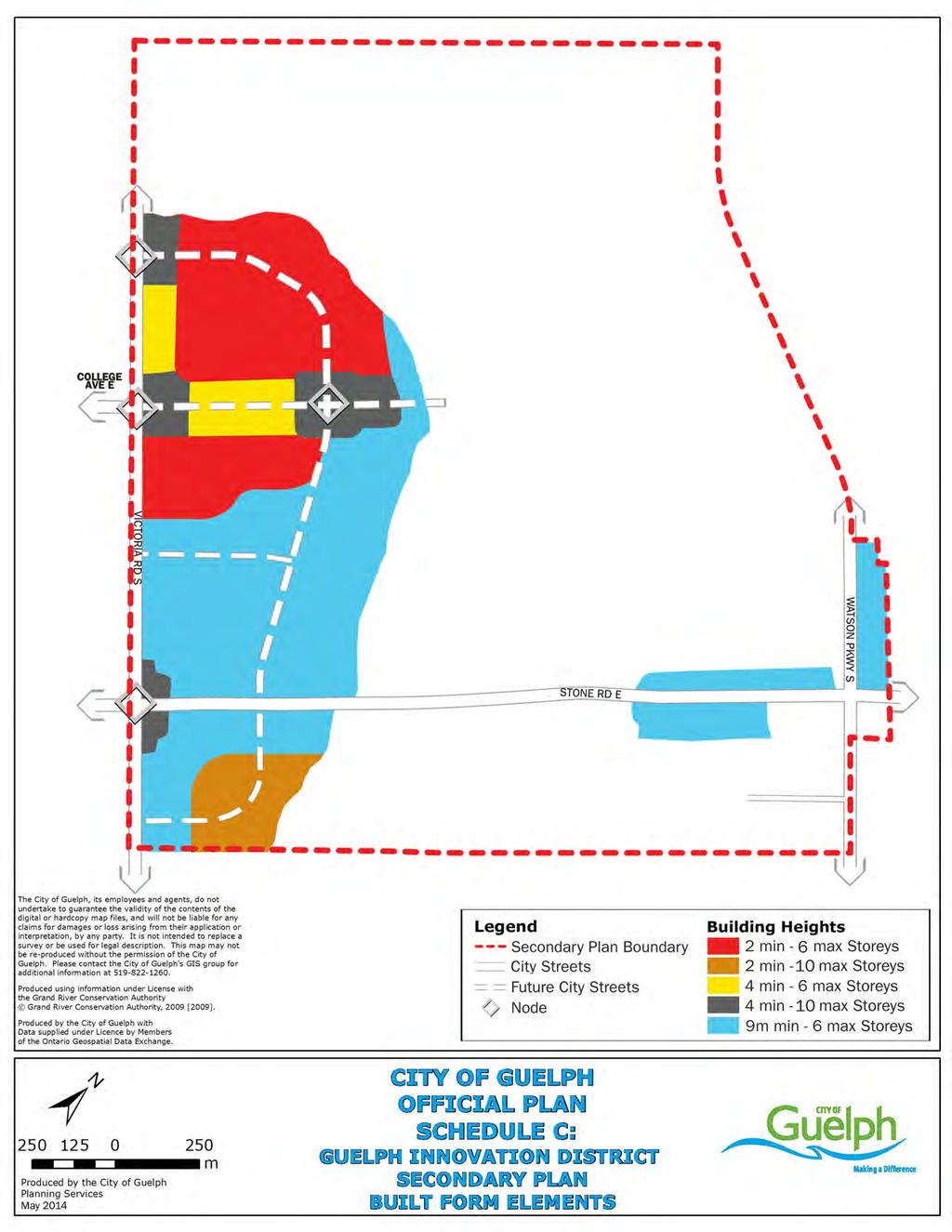
359
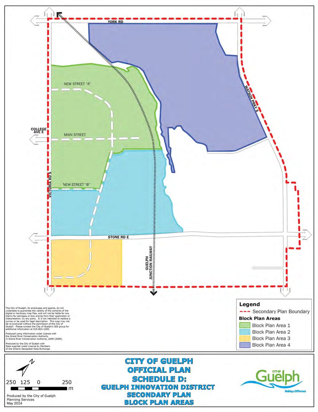
360
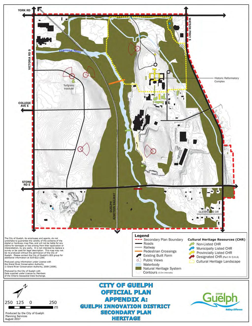
361
362 12 Glossary The terms as listed in the Glossary have a specific technical meaning as used in the Plan text. They are italicized in the body of the Plan in instances where this technical meaning applies. The terms are listed in alphabetical order. 100 Year Flood means: the flood which has a return period of 100 years, on average, or which has a 1% chance of occurring or being exceeded in any given year, as determined by the Grand River Conservation Authority. Accessory Apartment means: a dwelling unit located within and subordinate to an existing single detached dwelling or semi-detached dwelling. Active Transportation means: Modes of transportation, such as walking and cycling that: provide the personal benefits of fitness and recreation; are environmentally friendly; contribute to the personal and social health of neighbourhoods; and are readily available to a wide range of age groups within the community. Adjacent Lands means: For the purpose of designated property or protected heritage property, any parcel of land that: i) shares a boundary with a parcel containing a designated property or protected heritage property; ii) is separated from a designated property or protected heritage property by a right of-way (e.g., road) and within the span of the extended lot lines of the parcel containing a designated property or protected heritage property or is located at a corner opposite a corner property that is a designated heritage property or protected heritage property; iii) is within 30 metres of a designated heritage property or protected heritage property in instances where a designated heritage property or protected heritage property is within a right-of-way (e.g. bridge) or located on a parcel 2.5 hectares in area or greater. Adjacent Lands means: for the purpose of the Natural Heritage System, those lands contiguous to specific natural heritage features or areas, where it is likely that development or site alteration would have a negative impact on the feature, area or ecological functions. The extent of the adjacent lands are defined in Table 6.1 of this Plan. Adverse Effects as defined in the Environmental Protection Act means one or more of: Impairment of the quality of the natural environment for any use that can be made of it; Injury or damage to property or plant and animal life; Harm or material discomfort to any person; An adverse effect on the health of any person; Impairment of the safety of any person; Rendering any property or plant or animal life unfit for use by humans; Loss of enjoyment of normal use of property; and City of Guelph Official Plan 345
363 Interference with normal conduct of business. Affordable Housing means: a) in the case of ownership housing, housing for which the purchase price is at least 10 percent below the average purchase price of a resale unit in the City of Guelph; b) in the case of rental housing, a unit for which the rent is at or below the average market rent of a unit in the City of Guelph. Affordable Housing Benchmark means: The maximum affordable housing price as defined for the City of Guelph for ownership and rental housing. The benchmark is adjusted on an annual basis to be reflective of changing market conditions within the city. Agricultural Use means: the growing of crops, including nursery and horticultural crops; raising of livestock and other animals for food, fur or fibre, including poultry and fish; aquaculture; apiaries; agroforestry; maple syrup production; and associated on-farm building and structures. Alter (and alteration) means: A change in any manner, and includes to restore, renovate, repair or disturb. Alternative energy systems means: sources of energy or energy conversion processes that significantly reduce the amount of harmful emissions to the environment (air, earth and water) when compared to conventional energy systems. Ancillary Use means: A use that is incidental to, but associated with the principle use or a primary function of a site. Aquifer means: a subsurface geological material which yields significant amounts of water. Archaeological Assessment means: For a defined project area or property, a survey undertaken by a licensed archaeologist within those areas determined to have areas of potential archaeological resources in order to identify archaeological sites, followed by evaluation of their cultural heritage value or interest, and determination of their characteristics. Based on this information, recommendations are made regarding the need for mitigation of impacts and the appropriate means for mitigating those impacts. Archaeological Resources means: Includes artifacts, archaeological sites and marine archaeological sites. The identification and evaluation of such resources are based upon archaeological fieldwork undertaken in accordance with the Ontario Heritage Act. Archaeological Site means: Any property that contains an artifact, or any other physical evidence of past human use or activity that is of cultural heritage value or interest. City of Guelph Official Plan 346
364 Area of Natural and Scientific Interest (ANSI) means: areas of land and water containing natural landscapes or features which have been identified by the Province (MNR) as having science or earth science values related to protection, scientific study or education. Areas of Potential Archaeological Resources means: areas with the likelihood to contain archaeological resources. The criteria for determining archaeological potential is based on the presence of a wide range of features or characteristics, including but not limited to: i) previously identified archaeological sites; ii) water sources; iii) elevated topography; iv) pockets of well-drained sandy soil; v) distinctive landforms; vi) resource areas (including food or medicinal plants, scarce raw materials, or early Euro-Canadian industry); vii) areas of early Euro-Canadian settlement; viii) early historical transportation routes; ix) property listed on a Municipal Register, or designated under the Ontario Heritage Act or that is a federal, provincial or municipal historic landmark or site; x) property that local histories or informants have identified with possible archaeological sites, historical events, activities, or occupations. Archaeological potential is confirmed through archaeological fieldwork undertaken in accordance with the Ontario Heritage Act. The features indicating archaeological potential are described in detail in the Ministry of Tourism and Culture s Standards and Guidelines for Consultant Archaeologists (2010). Artifact means: Any object, material or substance that is made, modified, used, deposited, or affected by human action and is of cultural heritage value or interest. Bankful Channel means: The usual or average level to which a body of water rises at its highest point and remains for sufficient time so as to change the characteristics of the land (also known as the ordinary High Water Mark HWM). In flowing waters (rivers, streams) this refers to the active channel which is often the 1:2 year flood flow return level (Department of Fisheries and Oceans, 2010). Brownfield sites means: undeveloped or previously developed properties that may be contaminated. They are usually, but not exclusively, former industrial or commercial properties that may be underutilized, derelict or vacant. Buffers means: areas identified adjacent to some natural heritage features or areas that are intended to be protected and provide a separation between the protected feature or area and the adjacent development, and mitigate against negative impacts to the natural heritage feature or area and/or its ecological function(s). City of Guelph Official Plan 347
365 Built Heritage Resource means: one or more significant buildings, structures, landscapes, monuments, installations or remains associated with architectural, cultural, social, political, economic or military history and identified as being important to a community. These resources may be identified through designation or heritage conservation easement under the Ontario Heritage Act, or listed by local, provincial or federal jurisdictions. Built heritage resources include those properties that have been included in the Couling Architectural Inventory as it is completed and as it may be amended. All buildings, structures, landscapes, monuments, installations or visible remains constructed prior to 1927, but not limited to those constructed prior to 1927,shall be considered to be built heritage resources until considered otherwise by Heritage Guelph. Built-up area means: lands identified within the built boundary as approved by the Minister of Energy and Infrastructure in accordance with Section of the Growth Plan and as identified on Schedule 1. Child Care Centre see Day Care Centre Coach House means: a one unit detached residence containing bathroom and kitchen facilities that is located on the same lot, but is subordinate to an existing residential dwelling and is designed to be a permanent unit. Committee of Adjustment means: a quasi-judicial body, appointed by City Council in accordance with the Planning Act, authorized to rule on applications for minor variances to zoning by-laws, for enlargements and extensions to non-conforming buildings, for conversions of non-conforming uses and buildings to other non-conforming uses, to interpret general clauses in by-laws, and for consents in accordance with the provisions of the Planning Act. Community Infrastructure means: lands, buildings, and structures that support the quality of life for people and communities by providing public services for health, education, recreation, socio-cultural activities, security and safety and the provision of programs and services provided or subsidized by a government or other body, such as social assistance and affordable housing. Community infrastructure does not include infrastructure or municipal services. Compact Urban Form means: a land-use pattern that encourages efficient use of land, walkable communities, mixed land uses (residential, retail, workplace and institutional all within one neighbourhood), is in proximity to transit and reduces need for infrastructure. Compact urban form can include detached and semi-detached houses on small lots as well as townhouses and walk-up apartments, multi-storey commercial developments, and apartments or offices above retail. Compatibility/compatible means: Development or redevelopment which may not necessarily be the same as, or similar to, the existing development, but can co-exist with the surrounding area without unacceptable adverse impact. City of Guelph Official Plan 348
366 Complete Community means: a city that meet people s needs for daily living throughout an entire lifetime by providing convenient access to an appropriate mix of jobs, local services, a full range of housing, and community infrastructure including affordable housing, schools, recreation and open space for their residents. Convenient access to public transportation and options for safe, nonmotorized travel is also provided. Condominium means: a form of property ownership in which title to a unit, such as an individual apartment or townhouse unit is held by an individual together with a share of the rest of the property, which is common to all of the owners. Consent means: the authorization granted by the Committee of Adjustment in accordance with the Planning Act, to deal with land severance, lot additions, easements, rights-of-way, validation of title, charge/discharge of mortgages and long term leases of land for more than 21 years. A consent is not needed to convey, mortgage, grant or lease an entire lot, or a whole lot on a registered plan of subdivision. Conserved (and conservation) means: In regard to cultural heritage resources, the identification, protection, use and/or management of cultural heritage resources and archaeological resources in such a way that their heritage attributes and integrity are retained. This may be addressed though a cultural heritage conservation plan or cultural heritage resource impact assessment. Consolidated Municipal Service Manager (Service Manger) means: The legislated agency appointed by the Province that is responsible for the delivery of social housing services within Guelph and Wellington County. The County of Wellington is responsible for this service within the City and the County. Convenience Commercial means: a small-scale commercial operation and personal service that has a planning function of serving the day-to-day convenience shopping needs of an immediately surrounding residential population. Examples of uses include a convenience food store, a dry cleaner or a small-scale restaurant. Conversion means: the alteration or change of use of an existing building or structure to some other use. Co-ownership means: a form of property possession in which a person has a joint interest in a co-operative or as a member of a corporation with the stated right to a present or future exclusive possession to a dwelling unit within a multiple unit residential building. Cultural Heritage Conservation Easement Agreement means: A voluntary legal agreement between the heritage property owner, the municipality and/or the Ontario Heritage Trust, establishing mutually accepted conditions that will ensure the conservation of a heritage property in perpetuity. Cultural Heritage Conservation Plan means: A plan developed to demonstrate how heritage attributes will be conserved, protected or City of Guelph Official Plan 349
367 enhanced such that the integrity of the heritage attributes is retained. Such plans will include descriptions of repairs, stabilization and preservation techniques as well as short and long term conservation and maintenance measures and including how the heritage attributes will be integrated or commemorated. Cultural Heritage Landscape means: a defined geographical area of heritage significance which has been modified by human activities and is valued by the community. It may involve a grouping(s) of individual heritage features such as structures, spaces, archaeological sites, and natural elements, which together form a significant type of heritage form, distinctive from that of its constituent elements or parts. Examples may include, but are not limited to Heritage Conservation Districts designated under the Ontario Heritage Act, parks, gardens, neighbourhoods, townscapes, farm-scapes, battlefields, main streets, cemeteries, trail ways and industrial complexes of cultural heritage value or interest. Cultural Heritage Resource means: an archaeological resource, built heritage resource or cultural heritage landscape resource. Cultural Heritage Resource Impact Assessment means: a study conducted prior to development/redevelopment to investigate the potential impact of development on cultural heritage resources. This type of study will determine how a particular development should proceed and what actions or measures are required to minimize negative impacts on cultural heritage resources. Cultural Heritage Review means: An assessment conducted to accompany a request to modify a description of nondesignated properties listed in the Heritage Register or to list or remove non-designated properties from the Heritage Register. Cultural Heritage Value or Interest means: A property is of cultural heritage value or interest if, where criteria for whether the property is of cultural heritage value or interest has been prescribed by regulation, the property meets the criteria. Cultural Resources (see Cultural Heritage Resource definition). Cultural Woodland means: a woodland with tree cover between 35% and 60% originating from, or maintained by, anthropogenic, influences and culturally based disturbances (e.g., planting or agriculture, clearing, recreation, grazing or mowing); often having a large proportion of introduced (i.e., non-indigenous) species (as per the Ecological land Classification System for southern Ontario) and with shrubs, grasses, and/or herbaceous ground cover. These may be second or third growth woodlands that occur on land that has been significantly altered by human disturbance where the original forest was completely or mostly removed at various points in time (e.g., from agriculture, grazing, gravel extraction) and may include a small proportion of planted trees but has undergone natural succession to the point where tree cover is between 35% and 60%, with grass and herbaceous ground covers, and possibly shrubs as well. City of Guelph Official Plan 350
368 Day Care Centre means: a premise licensed under the Day Nurseries Act, that receives more than five children who are not of common parentage primarily for the purpose of providing temporary care or guidance, or both temporary care or guidance, for a continuous period not exceeding twenty-four hours, when the children are under eighteen years of age in the case of a day nursery for children with a developmental handicap and under ten years of age in all other cases. Density Targets means: the targets for the Urban Growth Centre density contained in policy of this Plan and for designated greenfield areas density targets contained in policy Deposits of mineral aggregate resources means: An area of identified mineral aggregate resources, as delineated in Aggregate Resource Inventory Papers or comprehensive studies prepared using evaluation procedures established by the Province for surficial and bedrock resources, as amended from time to time, that has a sufficient quantity and quality to warrant present or future extraction. Designated and Available means: with respect to housing supply, lands designated in the Official Plan for urban residential use. Where more detailed official plan policies (e.g., secondary plans) are required before development applications can be considered for approval, only lands that have commenced the more detailed planning process are considered to be designated for the purpose of this definition. Designated Property means: For the purpose of cultural heritage, property designated by a municipality under Part IV of the Ontario Heritage Act or within a Heritage Conservation District designated under Part V of the Ontario Heritage Act. Development means: a) The creation of a new lot, a change in land use, or the construction of buildings and structures requiring approval under the Planning Act; b) Site alteration activities such as fill, grading and excavation that would change the landform and natural vegetative characteristics of a site; and c) Various forms of intensification, infill development and redevelopment. Development does not include activities that create or maintain infrastructure authorized under an environmental assessment process or works subject to the Drainage Act. In spite of the above definition, for the Special Policy Area Flood Plain of this Plan, development means the construction, erection or placing of one or more buildings or structures on lands, or an addition or alteration to a building or structure which adds more than 50% of the existing ground floor space area to the building or structure. District Energy means: A system that ties together distributed thermal energy generation and users through a local supply loop. Dwelling Unit means: a room or group of rooms occupied or designed to be occupied as an independent and separate self-contained housekeeping unit. City of Guelph Official Plan 351
369 Easement means: the permission to use a part of an individual's property, usually for services that are either overhead (as wires) or underground (i.e. pipes) and, furthermore, to service such installations. Ecological Functions means: the natural processes, products or services that living and non-living environments provide or perform within or between species, ecosystems and landscapes. These may include biological, physical, chemical and socio-economic interactions. With respect to wetlands, ecological functions mean the biological, physical and socioeconomic interactions that occur in an environment because of the properties of the wetlands that are present, including, but not limited to groundwater recharge and discharge; flood damage reduction; shoreline stabilization; sediment trapping; nutrient retention and removal; food chain support; habitat for fish and wildlife; and attendant social and economic benefits. Ecological Linkage means: areas identified based on the principles of conservation biology that connect Significant Natural Areas and/or protected Habitat for Significant Species and along which wildlife can forage, genetic interchange can occur, and populations can move from one habitat to another in response to life cycle requirements. Ecological Linkages provide or enhance connectivity where it is otherwise lacking, ensuring a systems based approach, and supporting natural connections between Significant Natural Areas and/or protected Habitat for Significant Species. Ecological Linkages can also include those areas currently performing, or with the potential to perform linkage functions through restoration measures. Although linkages help to maintain and improve the Natural Heritage System and related ecological functions, they can also serve as habitat in their own right. Ecosystem Services means: the broad range of services provided by natural heritage features and areas within a given jurisdiction. These services include contributions to: surface and groundwater protection, air quality improvement, erosion and flood control, localized temperature moderation, noise attenuation, visual barriers, soil and wildlife protection and regeneration, and pollination of crops and natural vegetation. A number of these services can also be attributed to trees and treed areas outside natural areas but within the urban matrix (e.g., trees on boulevards, in yards and parks, etc.) Employment Area means: those areas designated in the Official Plan for clusters of businesses and economic activities including, but not limited to: i) manufacturing uses; ii) warehousing uses; iii) office uses; iv) retail uses that are associated with the uses mentioned in clauses i) to iii); and iii) Facilities that are ancillary to the uses mentioned in clauses i) to iv). Endangered Species means: a species that is listed or categorized as an Endangered Species on the Ministry of Natural Resources official species at risk list, as updated and amended from time to time.. City of Guelph Official Plan 352
370 Environmental Assessment (EA) means: a planning process to determine the potential impacts of an infrastructure project as determined by the Environmental Assessment Act. Environmental Corridor means: a linear biophysical feature usually associated with natural topographic, surface water and vegetation features such as wetlands, rivers and creeks, valleylands and wooded areas. These corridors serve as essential passageways for native plant and animal species and communities including: migratory routes; passage between different habitat types for animals requiring a variety of habitat types to survive and; pathways for movement and reproductive interchange between different populations of the same plant or animal species. In addition, where these corridors are associated with streams, these natural corridors also serve as essential buffers to protecting the integrity of the stream s ecosystem. Environmental Impact Study (EIS) means: the form or product a study used in the context of natural heritage features and areas where development provisions on or adjacent to a natural heritage feature have been established through a rigorous ecosystems-analysis approach. This will usually take the form of a (sub) watershed study or environmental overview based on a landscape scale review of a natural features and functions of an area. Erosion Hazard means: The loss of land, due to human or natural processes, that poses a threat to life and property. The erosion hazard limit is determined using considerations that include the 100 year erosion rate (the average annual rate of recession extended over a one hundred year time span), an allowance for slope stability and an erosion/erosion access allowance. Essential means: that (1) there is a demonstrated need, and (2) it has been demonstrated that no other reasonable alternatives exist. Established Buffers means: the buffers established and approved by the City following the adjacent lands analysis carried out through the required site specific study (e.g. EIS or EA). Exempt means: In regard to energy projects, an energy project that is exempt from Planning Act approvals as outlined in Section 62 of the Planning Act. (see also non-exempt) Extirpation means: a wildlife species no longer existing in a given jurisdiction where it formerly occurred, but still occurring elsewhere. Feature (see Natural Heritage Features and Areas definition). Federally Significant Species means: species that are listed by the Federal Species at Risk Act as i) endangered or threatened or Special Concern, but are not listed provincially (i.e., Endangered or Threatened Species as defined in this Plan). City of Guelph Official Plan 353
371 Fish means: fish, shellfish, crustaceans, and marine animals, at all stages of their life cycles. Fish habitat means: spawning grounds and nursery, rearing, food supply and migration areas on which fish depend directly or indirectly in order to carry out their life processes. Flood means: a temporary rise in the water level resulting in the inundation of areas in the floodplain not ordinarily covered by water. Flood Lines (see Regulatory Flood Lines definition). Flood Fringe means: the outer portion of the floodplain between the floodway and the flooding hazard limit. Flooding Hazard means: The inundation, under the conditions specified below, of areas adjacent to a shoreline or a river or stream system and not ordinarily covered by water. i) Along the shorelines of the Great Lakes - St. Lawrence River System and large inland lakes, the flooding hazard limit is based on the one hundred year flood level plus an allowance for wave uprush and other water-related hazards; ii) Along river, stream and small inland lake systems, the flooding hazard limit is the greater of: a) the flood resulting from the rainfall actually experienced during a major storm such as the Hurricane Hazel storm (1954), transposed over a specific watershed and combined with the local conditions, where evidence suggests that the storm event could have potentially occurred over watersheds in the general area; b) the one hundred year flood; and c) a flood which is greater than a. or b. which was actually experienced in a particular watershed or portion thereof as a result of ice jams and which has been approved as the standard for that specific area by the Minister of Natural Resources; d) where the use of the one hundred year flood or the actually experienced event has been approved by the Minister of Natural Resources as the standard for a specific watershed (where the past history of flooding supports the lowering of the standard). Floodplain means: the area, usually low lands, adjoining a watercourse, which has been, or may be subject to flooding hazards. The regulatory floodline delimits the boundaries of the floodplain. Floodproofing (and floodproof and floodproofed) means: a combination of structural changes and/or adjustments incorporated into the basic design and/or construction or alteration of individual buildings, structures or properties subject to flooding so as to reduce or eliminate flood damages. Floodway means: a portion of the floodplain where development and site alteration would cause a danger to public health or safety or property damage. City of Guelph Official Plan 354
372 Where the one zone concept is applied, the floodway is the entire contiguous floodplain. Where the two zone or Special Policy Area concept are applied, the floodway is the contiguous inner portion of the floodplain, representing that area required for the safe passage of flood flow/or that area where flood depths and/or velocities are considered to be such that they pose a potential threat to life or property damage. Where the two zone or Special Policy Area concept are applied, the outer portion of the floodplain is called the flood fringe. Forest Management means: the sustainable management of the woodland to maintain, restore or enhance environmental conditions for wildlife, and for the protection of water supplies and may include the removal or pruning of dead, diseased, and hazard trees, and invasive species. Management may also include the judicious removal of selected tree(s) to improve the diversity and health of the woodland e.g., selective cutting of plantations to permit natural succession to occur. However, forest management does not include the removal of trees solely for commercial purposes. Functions (see Ecological Functions definition). Garden Suite means: (also known as a Granny Flat): A one-unit detached residential structure containing bathroom and kitchen facilities that is separate from and subordinate to an existing residential dwelling and that is designed to be portable. Globally Significant Species means: species that are considered globally significant (i.e., ranked as G1, G2 or G3) by the Nature Conservancy, as listed by the Ontario Ministry of Natural Resource s Natural Heritage Information Centre. Greenfield area means: the area within the settlement area boundary that was not part of the built-up area in 2006 and is not part of the non-settlement areas identified on Schedule 1B. Greyfield means: previously developed properties that are not contaminated. They are usually, but not exclusively, former commercial properties that may be underutilized, derelict or vacant. Gross Floor Area means: the total floor area of a building that is designed and intended for exclusive use and occupancy by a tenant or owner measured from the centre line of partition walls and from the exterior face of outside walls. Groundwater means: the water held beneath the earth's surface, especially water that flows or seeps downward and saturates the soil. The upper level of this saturated zone is called the water table. City of Guelph Official Plan 355
373 Groundwater Feature means: water-related features in the earth s subsurface, including recharge/discharge areas, water tables, aquifers and unsaturated zones that can be defined by surface and subsurface hydrogeologic investigations. Group Home means: a single housekeeping unit in a dwelling unit licensed, approved or supervised by the Province of Ontario under any general or specialized or group accommodation with responsible 24 hour supervision consistent with the requirements of its residents. Without limiting the generality of the foregoing, a group home does not include a day care centre, a crisis care centre or a halfway house. Growth Plan means: The Growth Plan for the Greater Golden Horseshoe (2006), as amended from time to time, prepared and approved under the Places to Grow Act (2005). Habitable Floor Space means: any room or space in a dwelling unit designed for living, sleeping, the preparation of food and sanitary facilities; and also includes hotels and motels for overnight accommodation. Habitat Conservation means: management practices that aim to conserve, protect and restore wildlife habitat in order to increase biodiversity, including but not limited to: introduction of indigenous species and removal of non-indigenous invasive species. Hazards or Hazardous (see Hazard Lands definition). Hazard(ous) Lands means: property or land that could be unsafe for development due to naturally occurring processes. This means land, including that covered by water, to the furthest landward limit of the flooding hazard or erosion hazard limits. Hazardous Site means: Property or land that could be unsafe for development and site alteration due to naturally occurring hazards. These may include unstable soils, organic soils or unstable bedrock (karst topography). Hazardous substances means: Substances which, individually, or in combination with other substances, are normally considered to pose a danger to public health, safety and the environment. These substances generally include a wide array of materials that are toxic, ignitable, corrosive, reactive, radioactive or pathological. Hedgerow means: trees left standing or planted along the edge of a former or existing agricultural field or laneway to create a physical and/or visual barrier. Hedgerows also typically include trees remaining along former fence lines. Heritage attributes means: In relation to real property, and to the buildings and structures on the real property, the City of Guelph Official Plan 356
374 attributes of the property, buildings and structures that contribute to their cultural heritage value or interest. Heritage Conservation District means: An area with a group or complex of buildings, or a larger area with many buildings and properties, with a concentration of cultural heritage resources with special character or historical association that distinguishes it from its surroundings. Heritage Conservation District Plan means: A document adopted by the City to manage and guide future change in a Heritage Conservation District, through the adoption of a district plan with policies and guidelines for conservation, protection and enhancement of the Heritage Conservation District s special character. Heritage Register (see: Municipal Register of Cultural Heritage Properties) Heritage Tree means: A single tree (or group of trees) which has cultural heritage value or interest. Heritage trees may be located on private and/or public property or form part of a cultural heritage landscape. Heritage trees may be identified as a heritage attribute of a non-designated property listed in the Municipal Register of Cultural Heritage Properties under the Ontario Heritage Act. Heritage trees may be identified as part of a Cultural Heritage Resource Impact Assessment, Cultural Heritage Conservation Easement Agreement, Cultural Heritage Review, Environmental Impact Statement, Environmental Assessment Study or through a specific tree study. Highway-Oriented Service Commercial means: service commercial uses that are particularly well suited to a highway location. These uses usually comprise business activities that require expansive storage components to their operation or are activities catering to tourists and inter-urban traffic. Hummocky Topography means: the character of land as displayed by the Paris Galt Moraine consisting of a topography highlighted by concave and convex slopes connecting a high diversity of slope classes. (i.e., more than one of the following: <5%, >=5% to <10%, >=10% to <15%, >=15% to <20%, and >=209%) and generally incorporating closed depressions, ridges and/or hilltops. Hydrologic Function means: the functions of the hydrological cycle that include the occurrence, circulation, distribution and chemical and physical properties of water on the surface of the land, in the soil and underlying rocks, and in the atmosphere, and water s interaction with the environment including its relation to living things. Impact (see Negative Impact definition). Individual On-Site Sewage Services means: Individual, autonomous sewage disposal systems within the meaning of s.8.1.2, O Reg. 403/97, under the Building Code Act that are owned, operated and managed by the owner City of Guelph Official Plan 357
375 of the property upon which the system is located. Individual On-Site Water Services means: Individual, autonomous water supply systems that are owned, operated and managed by the owner of the property upon which the system is located. Industrial Park means: a planned or organized industrial district with a comprehensive plan which is designed to insure compatibility between the industrial operations therein and the existing activities and character of the community in which the park is located. The plan must provide for streets designed to facilitate truck and other traffic, proper setbacks, lot size minimums, land use ratio minimums, architectural provisions, landscaping requirements, and specific use requirements. Infill Development means: a form of development within an older established area of the city on land that has not previously been built on. Infrastructure means: physical structures and services (facilities and corridors) that form the foundation for development. Infrastructure includes: sewage and water systems, stormwater management facilities, septage treatment systems, waste management systems, electric power generation and transmission, communications/telecommunications, transit and transportation corridors and facilities, and oil and gas pipelines and associated facilities. Intensification means: the development of a property, site or area at a higher density than currently exists through: a) redevelopment, including the reuse of brownfield sites; b) the development of vacant and/or underutilized lots within previously developed areas; c) infill development; and d) the expansion or conversion of existing buildings. Intensification Area means: lands identified by municipalities within a settlement area that are to be the focus for accommodating intensification. Intensification areas include Downtown Guelph, intensification corridors, major transit station areas, and other major opportunities that may include infill, redevelopment, brownfield sites, the expansion or conversion of existing buildings and greyfields. Intensification Corridors means: intensification areas identified along major roads, arterials or higher order transit corridors that have the potential to provide a focus for higher density mixed-use development consistent with planned transit service levels. Intensification Target means: the target as established in Section 3.7 of the Official Plan in accordance with section of the Growth Plan. City of Guelph Official Plan 358
376 Intermittent Stream means: watercourses that only flow during wet periods (30 to 90% of the time) and flow in a continuous, well-defined channel. These are distinguished from ephemeral streams which refer to water that only flows during storm events and may or may not have a well-defined channel. Invasive Species means: species of plants, animals and microorganisms introduced by human action outside their natural past or present distribution whose introduction or spread threatens the environment. An invasive plant is one that has been moved from its indigenous habitat to a new area (possibly for garden/domestic use), and reproduces so aggressively that it displaces species within indigenous plant communities. Land Severance (see Consent definition). Landfill Site means: a site used for the disposal of waste by deposit, under controlled conditions, on land. LEED means: Leadership in Energy and Environmental Design: a system for rating buildings based on their environmental performance including energy and water use. Legal non-conforming means: A use of land, building or structure that is not recognized in the Zoning By-law but which lawfully existed on the day the Zoning By-law was passed. Linear Infrastructure means: corridors that include infrastructure such as the pipes necessary for the transmission and distribution of sewage (including stormwater) and water, communication, hydro, oil, and gas lines, but does not include transportation infrastructure. List (Listed or Listing) means: For the purposes of identifying cultural heritage resources, the addition of a designated property or non-designated property to the Municipal Register of Cultural Heritage Properties. Live/work means: a dwelling unit that may be partially used for the operation of a small scale business. Livestock-based Agricultural Operation means: a place where the grazing, breeding, raising, boarding or training of animals or birds occurs for commercial purposes. Living Community Centre means: Programming and/or improved animation of parks that strengthen community cohesion and pride through the introduction of activities such as, but not limited to, movie nights, walking clubs, family pick-up games and activities, neighbourhood picnics, community gardens, brick bake ovens, markets and talent nights. City of Guelph Official Plan 359
377 Locally Significant Species means: species that are not Endangered or Threatened Species but that are considered locally significant at the regional level (i.e., as identified in the Significant Plant List and the Significant Wildlife List for Wellington County, and any City-approved updates to these lists). Such species may also be considered Globally, Federally and/or Provincially Significant. Locally Significant Wetlands means: evaluated wetland (including wetland complexes) of at least two (2) hectares in size which are not identified as provincially significant, and unevaluated wetlands of at least 0.5 hectares in size. Lodging House means: any place, including but not limited to a dwelling unit, that is used to provide 5 or more lodging units for hire or gain directly or indirectly to persons. Low and Moderate Income Households means: i) In the case of ownership housing, households with incomes in the lowest 60 percent of the income distribution within the city; or ii) In the case of rental housing, households with incomes in the lowest 60 percent of the income distribution for households renting within the city. Low Impact Development means: a stormwater management strategy that seeks to mitigate the impacts of increased runoff and stormwater pollution by managing runoff as close to its source as possible. LID comprises a set of site design strategies that minimize runoff and distributed, small scale structural practices that mimic natural or pre-development hydrology through the processes of infiltration, evapotranspiration, harvesting, filtration and detention of stormwater. Site specific designs that can be used to control stormwater include, but are not limited to, rainwater harvesting, green roofs, bio-retention, permeable pavers, infiltration facilities and vegetated swales. These practices can effectively remove nutrients, pathogens and metals from runoff, and they reduce the volume and intensity of stormwater flows. Main Street Area means: A pedestrian oriented commercial or mixed-use area centred on a public street, private road or internal driveway that provides a focal point for surrounding neighbourhoods. Major Offices generally means: freestanding office building having a minimum of 10,000 sq.m. (107,639 Sq.ft.) and 500 jobs. Major Retail Uses means: retail uses that are greater than 3,250 sq.m. (34,982.7 sq.ft.). Major Transit Station Area means: the area generally defined as the area within an approximate 500 metre radius of a major bus depot or transit station, representing about a 10-minute walk. City of Guelph Official Plan 360
378 Mineral Aggregate Operation means: i) lands under license or permit, other than for a wayside pit or quarry, issued in accordance with the Aggregate Resources Act, or successors thereto. ii) for lands not designated under the Aggregate Resources Act, established pits and quarries that are not in contravention of municipal Zoning By-laws and including adjacent land under agreement with or owned by the operator, to permit continuation of the operation; and iii) associated facilities used in extraction, transport, beneficiation, processing or recycling of mineral aggregate resources and derived products such as asphalt and concrete, or the production of secondary related products. Mineral Aggregate Resources means: gravel, sand, clay, earth, shale, stone, limestone, dolostone, sandstone, marble, granite, rock or other material prescribed under the Aggregate Resources Act suitable for construction, industrial, manufacturing and maintenance purposes but does not include metallic ores, asbestos, graphite, kyanite, mica, nepheline syenite, salt, talc, wollastonite, mine tailings or other material prescribed under the Mining Act. Mitigation or Avoidance means: In regard to cultural heritage resources, methods of minimizing or avoiding a negative impact on a cultural heritage resource. These methods include, but are not limited to: i) alternative development approaches; ii) isolating development and site alteration from significant built and natural features and vistas; iii) design guidelines that harmonize mass, setback, setting, and materials; iv) limiting height and density; v) allowing only compatible infill and additions; vi) reversible alterations; and vii) buffer zones, site plan control, and other planning mechanisms. Minimum Buffer means: the minimum buffers identified on Table 6.1 of this Plan. Mode Share or Modal Share means: the percentage of person trips or of freight movements made by one travel mode relative to the total number of such trips made by all modes. Multi-modal means: the availability or use of more than one form of transportation, such as automobiles, buses, rail (commuter, light rail and freight), walking, and cycling. Municipal Comprehensive Review means: an Official Plan review, or an Official Plan amendment, initiated by a municipality that comprehensively applies the policies and schedules of this Plan. Municipal Register of Cultural Heritage Properties or Heritage Register means: A register established pursuant to Section 27 of the Ontario Heritage Act and filed with the Clerk which identifies properties of cultural heritage value or interest within the city. Designated properties are listed in the Municipal Register of Cultural Heritage Properties. City of Guelph Official Plan 361
379 Non-designated properties may also be listed in the Municipal Register of Cultural Heritage Properties. Municipal Sewage Services means: a sewage works within the meaning of Section 1 of the Ontario Water Resources Act, as amended from time to time, that is owned or operated by a municipality. Municipal Water means: A municipal drinking water system within the meaning of Section 2 of the Safe Drinking Water Act, as amended from time to time. Natural Areas (see Natural Heritage Features definition). Natural Hazards (see Hazard Lands definition). Natural Heritage Features and Areas means: significant wetlands and other wetlands, significant habitats of endangered and threatened species, significant Areas of Natural and Scientific Interest, surface water features and fish habitat, significant woodlands, significant landform, significant valleylands, ecological linkages and significant wildlife habitat, Restoration Areas, habitat of significant species and cultural woodlands as defined by the criteria in this Plan. Naturalization means: a process whereby an area that has been previously disturbed by humans or from natural events, is allowed to regenerate naturally with input of seeds and other propagules from the existing soil and/or adjacent natural areas. Negative Impacts means: i) In regard to water resources, degradation to the quality and quantity of water, sensitive surface water features and sensitive groundwater features, and their related hydrologic functions, due to single, multiple or successive development or site alteration activities. ii) In regard to fish habitat, the harmful alteration, disruption or destruction of fish habitat, except where, in conjunction with the appropriate authorities, it has been authorized under the Fisheries Act, using the guiding principle of no net loss of productive capacity; iii) In regard to other natural heritage features and areas, degradation that threatens the health and integrity of the natural features or ecological functions for which an area is identified due to single, multiple or successive development or site alteration activities. Negative Impacts means: In regard to cultural heritage resources, negative impacts include, but are not limited to: a) Destruction of any, or part of any, significant heritage attributes or features; b) Alteration that is not sympathetic, or is incompatible, with the historic fabric and appearance; c) Shadows created that alter the appearance of a heritage attribute or change the viability of a natural feature or plantings, such as a garden; d) Isolation of a heritage attribute from its surrounding environment, context or a significant relationship; e) Direct or indirect obstruction of significant views or vistas within, from, or of built City of Guelph Official Plan 362
380 and natural features; f) A change in land use such as rezoning a battlefield from open space to residential use, allowing new development or site alteration to fill in the formerly open spaces; g) Land disturbances such as a change in grade that alters soils, and drainage patterns that adversely affect an archaeological resource. Net Density means: the concentration of residential development, calculated by dividing the total number of dwellings by the net area of the site developed for residential purposes. This term excludes roads and road rights-of-way and areas that have been dedicated to the City or another public agency. Non-exempt means: In regard to energy projects, an energy project that is subject to approval under the Planning Act. (see also exempt) Non-settlement Area means: publicly owned land, which is not identified in the Official Plan for development or redevelopment up to the year 2031 as shown on Schedule 1. Normal Maintenance means: activities undertaken in conjunction with infrastructure including energy, communication, waste water, roads, railways, trails, water supply and storage, water management and stormwater management to ensure regular operation parameters and public safety in accordance with the associated guidelines, regulations and maintenance policies, procedures and risk mitigation strategies for the infrastructure. Nursing Home means: any premises, licensed under the Nursing Homes Act, maintained and operated for persons requiring nursing care. One Hundred Year Flood (see 100 Year Flood definition at beginning of Glossary). Ontario Heritage Act means: Ontario Heritage Act, R.S.O. 1990, c as amended. Other Wetlands means: unevaluated wetlands of at least 0.2 hectares and no more than 0.5 hectares. Paris Galt Moraine means: the geomorphic feature referred to as the Paris Galt Moraine Complex with is a 6.4 to 8 km wide belt that extends over most of the city s south end (south of Clair Road) and occurs in a few more isolated patches in the central portion of the city. The Paris and Galt Moraines were both deposited by the Ontario ice lob during the Port Bruce Stadial (15,000 14,000 yr. B.P.) Partial Services means: i) Municipal sewage services or private communal sewage services and individual on-site water services; or ii) Municipal water services or private communal water services and individual on- City of Guelph Official Plan 363
381 site sewage services. Passive Recreational Activities means: a range of outdoor activities and passive uses compatible with protecting the Natural Heritage features and areas including, but not limited to, wildlife habitat, wetlands and woodlands. Activities and uses include bird watching, hiking, photography, snowshoeing, and may require the construction of a trail, benches or boardwalks in accordance with the Guelph Trail Master Plan or are integral to the scientific, educational or passive recreational use of a property. Performance Labelling means: A transparent energy benchmarking process whereby the energy efficiency of a building is documented. Plans of Subdivision (see Registered Plan of Subdivision definition). Plantations means: where tree cover is greater than 60% and dominated by canopy trees that have been planted: i) managed for production of fruits, nuts, Christmas trees or nursery stock; or ii) managed for tree products with an average rotation of less than 20 years (e.g. hybrid willow or poplar); or iii) established and continuously managed for the sole purpose of tree removal at rotation, as demonstrated with documentation acceptable to the planning authority or the MNR, without a forest restoration objective. Pollinator Habitat means: natural areas within the landscape that contain indigenous plants, shrubs, and trees that provide pollen, nectar, and other floral resources for pollinating insects and other animal pollinators. In addition, these areas may provide appropriate nesting sites, such as exposed soil, rotting logs, cavity trees, hollow-stemmed plants, and host plants specific to local pollinators. Portable Asphalt Plant means a facility: a) With equipment designed to heat and dry aggregate and to mix aggregate with bituminous asphalt to produce asphalt paving material, and includes stockpiling and storage of bulk materials used in the process; b) Which is not of permanent construction, but which is to be dismantled at the completion of the construction project. Planning Act means: The Planning Act, R.S.O. 1990, chapter P.13, as amended. Portable Concrete Plant means: A building or structure: i) with equipment designed to mix cementing materials, aggregate, water and admixtures to produce concrete, and includes stockpiling and storage of bulk materials used in the process; and ii) which is not of permanent construction, but which is designed to be dismantled at the completion of the construction project. City of Guelph Official Plan 364
382 Property, as defined in Parts IV and V of the Ontario Heritage Act, means: Real property and includes all buildings and structures thereon. This includes anything fixed to the property fixture but excludes anything portable chattel. Generally, a fixture is something affixed to the property by means other than its own weight, which cannot be removed without causing damage to the building. A chattel is a moveable item of property not permanently attached to land or a building. Property Standards By-law means a municipal by-law, passed in accordance with the provisions of the Ontario Building Code which prescribes the standards for the maintenance and occupancy of property. Protected Heritage Property means: Real property designated under Parts IV, V, or VI of the Ontario Heritage Act; heritage conservation easement property under Parts II or IV of the Ontario Heritage Act; and property that is the subject of a covenant or agreement between the owner of the property and a conservation body or level of government, registered on title and executed with primary purpose of preserving, conserving and maintaining a cultural heritage feature or resource, or preventing its destruction, demolition or loss. Provincial Plan means: A plan approved by the Lieutenant Governor in Council or the Minister of Municipal Affairs and Housing, but does not include municipal Official Plans. Provincially Significant Species means: species that are not Endangered or Threatened Species but that are considered provincially significant by the MNR s Natural Heritage Information Centre (i.e., ranked as S1, S2 or S3) and/or listed as Special Concern at the provincial level by the Committee on the Status of Species at Risk in Ontario. Provincially Significant Wetlands means: wetlands or a wetland complex identified by the MNR as being of provincial significance as determined through the Ontario Wetland Evaluation System. Public Realm means: Public spaces such as public streets and rights-of-way, urban squares, parks, community trails, and open spaces. Public Service Facilities means: Land, buildings and structures for the provision of programs and services provided or subsidized by a government or other body, such as social assistance, recreation, police and fire protection, health and educational programs, and cultural services. Public service facilities do not include infrastructure. Public View means: A view toward important public and historic buildings, natural heritage and open space features, landmarks and skylines when viewed from the public realm. Public Vista means: Views that are framed through built form or between rows of trees when viewed from the public realm. City of Guelph Official Plan 365
383 Redevelopment means: the creation of new units, uses or lots on previously developed land in existing communities, including brownfield and greyfield sites. In spite of the above definition, for the lands within the Special Policy Area Floodplain of this Plan, redevelopment shall include an addition which is larger than 50% of the total ground floor area of the original or existing building or structure. Registered Plan of Subdivision means: a plan showing lots, streets and blocks of land, approved by the City of Guelph, in accordance with the Planning Act, and registered under the Registry Act, or the Land Titles Act. Regulatory Flood means: the flood resulting from the Hurricane Hazel Regional Storm, as determined by the Grand River Conservation Authority. Regulatory or Regional Flood Level means: a set of lines on either side of river or stream showing the highest water level which may be reached in the event of a regional storm as defined and calculated by the Grand River Conservation Authority. In Guelph, the regional flood is defined as the rainfall experience during the Hurricane Hazel storm of 1954 superimposed over the Grand River watershed. Renewable Energy means: the production of heat or energy from a renewable source such as, the sun, wind, water, biomass, biogas or geothermal. Renewable Energy Systems means: the production of power or heat from an energy source that is renewable by natural processes including, but not limited to, wind, water, a biomass resource or product, solar and geothermal energy. Renovation shall mean: for the Special Policy Area Flood Plain of this Plan, a form of development involving the improvement, alteration or addition under 50% of total ground floor area to an existing building or structure. Residential Intensification means: Intensification of a property, site or area which results in a net increase in residential units or accommodation and includes: a) redevelopment, including the redevelopment of brownfield sites; b) the development of vacant or underutilized lots within previously developed areas; c) infill development; d) the conversion or expansion of existing industrial, commercial and institutional buildings for residential use; and e) the conversion or expansion of existing residential buildings to create new residential units or accommodation, including accessory apartments, secondary suites and rooming houses. City of Guelph Official Plan 366
384 Restoration means: active management of an area that results in accelerated regeneration and recovery of a desired vegetation community or habitat, typically one that once occurred naturally in the area. This may include the creation or re-creation of wetlands, woodlands or meadows/grasslands. Retail Commercial means: an enterprise whose purpose is to sell a commodity to the end user. S-Ranks or Provincial Ranks means: Provincial (or Subnational) ranks are used by the NHIC to set protection priorities for rare species and natural communities. These ranks are not legal designation. Provincial Ranks are assigned in a manner similar to that described for global ranks, but consider only those factors within the political boundaries of Ontario. By comparing the global and provincial ranks, the status, rarity, and the urgency of conservation needs can be ascertained. The NHIC evaluates provincial ranks on a continual basis and produces updated lists at least annually. i) S1 Critically Imperiled Critically imperiled in the nation or state/province because of extreme rarity (often 5 or fewer occurrences) or because of some factor(s) such as very steep declines making it especially vulnerable to extirpation from the state/province. ii) S2 Imperiled Imperiled in the nation or state/province because of rarity due to very restricted range, very few populations (often 20 or fewer), steep declines, or other factors making it very vulnerable to extirpation from the nation or state/province. iii) S3 Vulnerable Vulnerable in the nation or state/province due to a restricted range, relatively few populations (often 80 or fewer), recent and widespread declines, or other factors making it vulnerable to extirpation. Safe Access means: Locations where, during the Regulatory Flood: i) the flow velocity does not exceed 1.0 m/sec.; ii) the product of depth and velocity does not exceed 0.4 metres squared/sec.; iii) the depth of flooding along access routes to residential units does not exceed 0.8 metres; iv) the depth of flooding along access routes to commercial or industrial buildings or structures does not exceed or 2.0 metres; v) the depth of flooding adjacent to residential units does not exceed 1.2 metres; and vi) the depth of flooding adjacent to commercial or industrial buildings or structures does not exceed 2.0 metres. Scoped Cultural Heritage Resource Impact Assessment means: a reduced scope of study conducted prior to development/redevelopment to investigate the potential impact of development on cultural heritage resources, including development proposals on lands adjacent to designated property or other protected heritage property. Scoped Environmental Impact Study (EIS) means: the form of study used in the context of assessing impact on natural heritage features where development within or adjacent to a natural heritage feature or area is contemplated City of Guelph Official Plan 367
385 and a comprehensive study (EIS/EA/Subwatershed Plan) has been completed. In this instance an area or site specific study that addresses the issues of particular concern not previously addressed in sufficient detail in the comprehensive studies will be examined for the site specific development proposal. Alternatively, this form of EIS may be used in instances where a Comprehensive EIS has not been undertaken, but the City, via its development approval process, requires a study to be conducted to assess impact on the features and adjacent lands thereto. Senior Citizen means: any person 60 years of age or older. Sensitive means: in regard to surface water features and groundwater features, areas that are particularly susceptible to impacts from activities or events including but limited to, water withdrawals, and additions of pollutants. Sensitive Land Use means: buildings, amenity areas or outdoor spaces where routine or normal activities occurring at reasonably expected times would experience one or more adverse effects from contaminant discharges generated by a nearby facility. Sensitive land uses may be a part of the natural or built environment. Examples may include, but not be limited to residences, day care centres, and educational and health facilities. Service Manager means: (see Consolidated Municipal Service Manager definition) Service Commercial means: uses that support highway-oriented or service-oriented commercial activities that cannot be readily located within the downtown area or within a shopping centre location. The following list characterizes the main features of a service commercial use: a) A use that requires a large site area and outdoor display area to accommodate the sale of large commodities such as cars, recreational vehicles, building supplies; b) A use that primarily relies on business from tourists and inter-urban traffic such as a hotel, gas bar, fast-food restaurant; c) A use that supplies goods and services that are not normally found within the downtown or a shopping centre such as auto repair and service facilities; d) A use that requires a location convenient to industry as it primarily provides service to industry such as machinery sales and service, electrical supplies; or e) A use that requires substantial showroom area because of the bulky or large size nature of the principal commodities that are being marketed, and the requirement for a large showroom makes it economically difficult to provide the space in the downtown or shopping centre location. Settlement area means: all lands identified in the Official Plan, excluding non-settlement areas, for development or redevelopment up to the year 2031 as shown on Schedule 1B. City of Guelph Official Plan 368
386 Significance (see Significant definition). Significant means: i) in regard to the habitat of provincially endangered and threatened species, means the habitat, as approved by the MNR, that is necessary for the maintenance, survival, and/or the recovery of naturally occurring or reintroduced populations of endangered species or threatened species, and where those areas of occurrence are occupied or habitually occupied by the species during all or any part(s) of its life cycle. ii) in regard to landform, means the portions of the Paris Galt Moraine containing concentrations of 20% slopes, and closed depressions located in close proximity to other Significant Natural Areas of the NHS. iii) in regard to wetlands means: a) provincially significant wetlands b) locally significant wetlands iv) in regard to woodlands means woodlands that are ecologically important in terms of features such as species composition, age of trees and stand history, functionally important due its contribution to the broader landscape because of its location, size or due to the amount of remaining forest cover in the city; a) in regard to valleylands means a protected natural heritage feature or area that occurs in a valley or other landform depression that has water flowing through or standing for some period of the year. This includes regulatory floodplains/riverine flooding hazards, riverine erosion hazards and apparent/other valleylands ecologically important in terms of features, functions, representativeness, or amount, and contributing to the quality and diversity of the Natural Heritage System; b) in regard to cultural heritage and archaeology, resources that are valued for the important contribution they make to our understanding of the history of a place, an event or a people.. Site Alteration means: activities such as grading, excavation and the placement of fill that would change the landform and natural vegetative characteristics of a site. Social Housing means: Sometimes referred to as assisted, subsidized or rent-geared-to income housing, housing that is a sub-set of affordable housing. It refers to housing units provided under a variety of federal and provincial housing program by the municipal non-profit housing corporation and private non-profit and co-operative non-profit housing corporations. Residents in rent-geared-to income units in social housing portfolios pay no more than 30% of their annual gross household income in rent. It also refers to housing units within the private rental sector, where rent-geared-to-income subsidy is provided through a rent supplement agreement to the landlord. Special Concern means: a species with characteristics resulting in sensitivity to human activities or natural events which may cause it to become endangered or threatened species. City of Guelph Official Plan 369
387 Special Needs Housing means: any housing, including dedicated facilities, in whole or in part, that is used by people who have specific needs beyond economic needs, including but not limited to, needs such as mobility requirements or support functions required for daily living. Examples of special needs housing may include, but are not limited to, housing for persons with disabilities such as physical, sensory or mental health disabilities, and housing for the elderly. For the purposes of this Plan, it also includes group homes, emergency shelters, special care facilities for persons with disabilities and housing for seniors (rest homes, palliative care, nursing homes). Subwatershed Plan means: a plan prepared by the City and/or the Grand River Conservation Authority. A Subwatershed Plan builds on findings of a Watershed Plan providing specific subwatershed targets, goals, objectives including but not limited to: natural system linkages and functions; surface and groundwater quantity and quality management; the enhancement, rehabilitation of natural features; areas suitable for development; best management practices for incorporation into subdivision designs; and specific implementation and monitoring schemes. Surface Water Features means: water related features, including headwaters, rivers, stream channels, inland lakes and ponds, seepage areas, recharge/discharge areas, springs, wetlands and associated riparian lands that can be defined by their soil moisture, soil type, vegetation and topographic characteristics. Threatened Species means: species that is listed or categorized as a Threatened species on the Ontario Ministry of Natural Resources official Species at risk list, as updated and amended from time to time by the Endangered Species Act. Transit-supportive means: making transit viable and improving the quality of the experience of using transit. When used in reference to development, it often refers to compact, mixed-use development that has a high level of employment and residential densities to support frequent transit service. When used in reference to urban design, it often refers to design principles that make development more accessible for transit users, such as roads laid out in a grid network rather than a discontinuous network; pedestrian-friendly built environment along roads to encourage walking to transit; reduced setbacks and placing parking at the sides/rear of buildings; and improved access between arterial roads and interior blocks in residential areas. Transportation Corridor means: a thoroughfare and its associated buffer zone for passage or conveyance of vehicles or people. A transportation corridor includes any or all of the following: a) Major roads, arterial roads, and highways for moving people and goods; b) Rail lines/railways for moving people and goods; c) Transit rights-of-way/transitways including buses and light rail for moving people. City of Guelph Official Plan 370
388 Transportation Demand Management (TDM) means: A series of policies, programs and incentives intended to influence whether, when, where and how people travel, and encourage them to make more efficient use of the transportation system. Transportation infrastructure means: Works such as maintenance, repair or installation of roads or bridges/overpasses as well as underpasses and culverts, and rail lines, but does not include buildings or parking that may be associated with these infrastructure components with the exception of small-scale bus/rail boarding platforms and associated structures. Tree Canopy Cover means: the proportion of land area occupied by tree crowns when visualized from above. It is the two-dimensional horizontal extent of the combined canopies of all the trees on a given land area. Urban Agriculture means: The growing of crops or raising of animals for food at a small scale that is compatible with the surrounding neighbourhood. It may also include small-scale sales of urban agricultural products subject to zoning and other applicable regulations. Urban Forest means: for the purposes of this Plan, plantations, woodlands, hedgerows, treed areas and individual trees outside the City s Natural Heritage System. Urban Growth Centre means: Downtown Guelph as identified on Schedule 1 and defined in accordance with the policies for the Growth Plan for the Greater Golden Horseshoe. Vacancy Rate means: the percentage of dwelling units that are vacant in relation to the total number of dwelling units of that type. A vacant dwelling unit is one that is available for immediate rental and is physically unoccupied at the time of enumeration. Valleylands means: a natural area that occurs in a valley or other landform depression that has water flowing through or standing for some period of the year. Vulnerable in regards to surface or groundwater means: surface and groundwater that can be easily changed or impacted by activities or events, either by virtue of their vicinity to such activities or events or by permissive pathways between such activities and the surface and/or groundwater. Walkable Communities means: well-designed, compact communities where people can walk to school or work, to stores, parks, restaurants and entertainment destinations thereby providing opportunities for exercise and significantly reducing the need to drive. Watershed means: all land drained by a river or stream and its tributaries. City of Guelph Official Plan 371
389 Watershed Plan means: a plan prepared by the City and/or the Grand River Conservation Authority, in consultation with Provincial Government ministries and local municipalities. The plan will take a broad ecosystem approach to water, water related natural features, terrestrial resources, fisheries, water dependencies/linkages and valley/open space systems. It is intended to provide watershed-wide policy and direction for: ecological integrity and carrying capacity; the protection of valley systems and green space planning; the management of water quantity and quality; aquifer and groundwater management; fisheries management; rehabilitation/enhancement programs; a framework for implementation of watershed policies and programs; regional opportunities/constraints; and document servicing needs/availability of water/sewerage. The plan will also delineate subwatershed planning areas and present targets, goals and objectives for subwatersheds. Wayside Pit and Quarry means: a temporary pit or quarry opened and used by or for a public authority solely for the purpose of a particular project or contract of road construction and not located on the road right-of-way. Wetland Evaluation means: evaluation of wetland carried out in accordance with the MNR Wetland Evaluation Manual, as amended from time to time. Wetlands mean: lands that are seasonally or permanently covered by shallow water, as well as lands where the water table is close to or at the surface. In either case the presence of abundant water has caused the formation of hydric soils and has favoured the dominance of either hydrophytic plants or water tolerant plants. The four major types of wetlands are swamps, marshes, bogs and fens. Wildlife Habitat means: areas where plants, animals and other organisms live and find adequate amounts of food, water, shelter and space needed to sustain their populations. Specific wildlife habitats of concern may include areas where species concentrate at a vulnerable point in their annual or life cycle; and areas, which are important to migratory or non-migratory species. Woodlands means: treed areas that provides environmental and economic benefits to both the private land owner and the general public, such as erosion prevention, hydrological and nutrient cycling, provision of clean air and the long-term storage of carbon, provision of clean air and the long-term storage of carbon, provision of wildlife habitat, outdoor recreational opportunities, and the sustainable harvest of a wide range of woodland products. Woodlands include treed areas, woodlots or forested areas and vary in their level of significance at the local, regional and Provincial levels. This includes an area of land at least 0.2 hectares in size with at least: i) 1000 trees of any size, per hectare; ii) 750 trees measuring over 5 centimetres diameter at breast height, per hectare; iii) 500 trees measuring over 12 centimetres diameter at breast height, per hectare; iv) 250 trees measuring over 20 centimetres diameter at breast height, per hectare, City of Guelph Official Plan 372
390 But does not include a cultivated fruit or nut orchard, a plantation established for the purpose of producing Christmas trees or nursery stock. For the purposes of defining woodland, treed areas separated by more than 20 metres will be considered a separate woodland. Zoning By-law means: a municipal by-law prepared in accordance with the Planning Act, that restricts the use of land and the manner in which buildings or structures are located on a property. A zoning by-law implements the intent of the Official Plan by specifically regulating what may or may not be done on individual parcels of land. Glossary of Acronyms ANSI Area of Natural and Scientific Interest EIR Environmental Implementation Report EIS Environmental Impact Study EA Environmental Assessment (under the Environmental Assessment Act) COSEWIC Committee on the Status of Endangered Wildlife in Canada COSSARO Committee on the Status of Species at Risk in Ontario dbh Diameter at breast height (for trees) DFO Department of Fisheries and Ocean GIS Geographic Information System GRCA Grand River Conservation Authority MNR Ministry of Natural Resources NHS Natural Heritage System NHIC Natural Heritage Information Centre (Ontario Ministry of Natural Resources) OMB Ontario Municipal Board PSW Provincially Significant Wetland SAR Species at Risk S1 Critically Imperiled (see definition under S-Ranks) S2 Imperiled (see definition under S-Ranks) S3 Vulnerable (see definition under S-Ranks) S4 Apparently Secure S5 Secure City of Guelph Official Plan 373
391 Schedules Schedule 1 Schedule 2 Schedule 3 Schedule 4 Growth Plan Elements Land Use Plan Development Constraints Natural Heritage System Schedule 4A Natural Heritage System- ANSIs and Wetlands Schedule 4B Natural Heritage System- Surface Water and Fish Habitat Schedule 4C Natural Heritage System- Significant Woodlands Schedule 4D Natural Heritage System- Significant Valleylands & Significant Landform Schedule 4E Natural Heritage System- Significant Wildlife Habitat & Habitat for Significant Species Schedule 5 Schedule 6 Schedule 7 Road & Rail Network Open Space System: Trail Network Wellhead Protection Areas City of Guelph Official Plan 374
392 SOUTHGATE DR WHITELAW RD SILVERCREEK PKY S HANLON EXPY SOUTHGATE DR SCOTTSDALE DR ALMA ST N STEVENSON ST N KATHLEEN ST This Schedule is to be read in conjunction with the other Schedules and the text of The Official Plan WELLINGTON RD 86 WELLINGTON RD 39 VICTORIA RD N G u e Guelph l p h L ELMIRA RD N WOODLAWN RD W SILVERCREEK PKY N EDINBURGH RD N NICKLIN RD BAILEY AVE G.J.R. Speed RIVERVIEW DR River WOODLAWN RD E WAVERLEY DR COUNTRY CLUB DR WINDSOR ST INVERNESS DR BRANT AVE MU SKOKA DR L a k e a WELLINGTON RD 124 k e SPEEDVALE AVE W SPEEDVALE AVE E SPEEDVALE AVE E TO VE LL DR WILLOW RD IMPERIAL RD N WILLOW RD DAWSON RD C.N.R. WESTMOUNT RD WOOLWICH ST DELHI ST EMMA ST ERAMOSA RD EASTVIEW RD WELLINGTON RD 31 FIFE RD ELMIRA RD S FIFE RD IMPERIAL RD S PAISLEY RD WESTWOOD R D S TEP HANIE DR C.N.R. C.N.R. WATERLOO AVE Speed River WELLINGTON ST W LONDON RD W SUFFOLK ST W YORKSHIRE ST N WATERLOO AVE WATER ST PAISLEY ST NORFOLK ST WYNDHAM ST N T MACDONELL ST WELLINGTON ST E ARTHUR ST N NEEVE ST METCALFE ST ELIZABETH ST C.N.R. G.J.R. GRANGE ST STEVENSON ST S H ADATI RD ELIZABETH ST GRANGE RD AUDEN RD CITYVIEW DR N STARWOOD DR YORK RD FLEMING RD WATSON PKY N MUNICIPAL ST DEAN AVE WATSON PKY S WATSON RD S WELLINGTON RD 124 Township of Guelph/Eramosa Township of Puslinch WHITELAW RD COLLEGE AVE W JANEFIELD AVE EDINBURGH RD S COLLEGE AVE W GORDON ST COLLEGE AVE E Eramosa River Township of Guelph/Eramosa SIDEROAD 10 N NISKA RD WOODLAND GL EN DR STONE RD W IRONWOOD RD HARVARD RD STONE RD E COOK'S MILL RD WATSON RD S STONE RD E Township of Puslinch PTARMIGAN DR K O R T R I G H T R D E IR O N W O OD R D KORTRIGHT RD W R I C K S O N A V E CARTER RD WELLINGTON RD 41 TEAL DR Legend LAIRD RD W DOWNEY RD HANLON CREEK BLVD ARKELL RD VICTORIA RD S FARNHAM RD City Streets Future City Streets County Roads Railways WELLINGTON RD 37 BOREHAM DR Watercourses Waterbodies Corporate Boundary SIDEROAD 12 WELLINGTON RD 35 FORESTELL RD CONCESSION 4 FORESTELL RD The City of Guelph, its employees and agents, do not undertake to guarantee the validity of the contents of the digital or hardcopy map files, and will not be liable for any claims for damages or loss arising from their application or interpretation, by any party. It is not intended to replace a survey or be used for legal description. This map my not be re-produced without the permission of the City of Guelph. Please contact the City of Guelph's GIS group for additional information at Produced using information under License with the Grand River Conservation Authority Grand River Conservation Authority, 2009 [2009]. Produced by the City of Guelph with Data supplied under Licence by Members of the Ontario Geospatial Data Exchange. LA IR D RD SIDEROAD 20 N HANLON EXPY LAIRD RD CLAIR RD W POPPY DR CLAIRFIELDS DR W CLAIR RD W GOSLING GDNS GORDON ST PINE RIDGE DR BEAVER MEADOW DR JENSON BLVD SU M M E RFIELD DR MALTBY RD W MALTBY RD E F A R L E Y D R CLAIRFIELDS DR E CLAIR RD E COLONIAL DR VICTORIA RD S MALTBY RD E Growth Plan Elements T Major Transit Station Intensification Corridors Community Mixed-Use Nodes Urban Growth Centre (Downtown Guelph) Built-Up Area Greenfield Area Settlement Area Boundary Non-Settlement Area WATSON RD S HUME RD ± CITY OF GUELPH OFFICIAL PLAN KM SCHEDULE 1: Projection: UTM 17N NAD83 Produced by the City of Guelph Planning Services ± GROWTH PLAN ELEMENTS I:\gis_staging\Planning\OFFICIAL PLAN MAPPING NEW\Schedule2\OPSchedule1-GrowthPlanElements.mxd
393 WHITELAW RD HANLON EXPY!!!!!!!!!!!!!!!!!! SILVERCREEK PKY S!!!!!!!!!!!!!!!!!!!!!!!!!!!!!!! SOUTHGATE DR! SOUTHGATE DR!!! ALMA ST N!! KATHLEEN ST!!!!! STEVENSON ST N!!!!!!!!!!!!!!!!!!!!!!!!!!!!!!!!!!!!!!!!!!!!!!!!!!!!!!!!!! This Schedule is to be read in conjunction with the other Schedules and the text of The Official Plan WELLINGTON RD 86 WELLINGTON RD 39 VICTORIA RD N G u e l p h L ELMIRA RD N WOODLAWN RD W (!!!!!!!!!!! SILVERCREEK PKY N EDINBURGH RD N NICKLIN RD BAILEY AVE G.J.R. RIVERVIEW DR WOODLAWN RD E WAVERLEY DR COUNTRY CLUB DR WINDSOR ST INVERNESS DR BRANT AVE MU SKOKA DR a WELLINGTON RD 124 k e SPEEDVALE AVE W!!!!!! SPEEDVALE AVE E SPEEDVALE AVE E TO VE LL DR WILLOW RD IMPERIAL RD N!!!!!!!!!!!!!!!!!!!!!!!!!!!!!!!!!!!!!!!!!!!!!!!!!!!!!!!!!!!!!!!!!!!!!!! WILLOW RD DAWSON RD C.N.R. WESTMOUNT RD WOOLWICH ST DELHI ST EMMA ST!!!!!!!!!! ERAMOSA RD!!!!!!!! EASTVIEW RD WELLINGTON RD 31 FIFE RD ELMIRA RD S FIFE RD IMPERIAL RD S PAISLEY RD WESTWOOD RD S TEP HANIE DR C.N.R. C.N.R.!!! WATERLOO AVE WELLINGTON ST W LONDON RD W SUFFOLK ST W YORKSHIRE ST N WATERLOO AVE WATER ST PAISLEY ST ARTHUR ST N Refer to Downtown Secondary Plan NORFOLK ST WYNDHAM ST N MACDONELL ST WELLINGTON ST E NEEVE ST!!!!!!!!!!!!!!!!!!!!!!!!! METCALFE ST ELIZABETH ST C.N.R. G.J.R. GRANGE ST STEVENSON ST S!!!!!!!!!!!!!!!!!!!!!!!!!!!!!!!!!!!!!!!!!!!!!!!!!!!!!!!!!!!!! H ADATI RD ELIZABETH ST GRANGE RD AUDEN RD CITYVIEW DR N STARWOOD DR YORK RD FLEMING RD WATSON PKY N!!!!!!! MUNICIPAL ST!!!!!!!!! DEAN AVE WATSON PKY S WATSON RD S WELLINGTON RD 124 Township of Guelph/Eramosa Township of Puslinch SIDEROAD 10 N WHITELAW RD NISKA RD COLLEGE AVE W WOODLAND GL EN DR (! JANEFIELD AVE!!!!!!!!!!!!!!!!!!!!!!!!!!!!!!!!!!!!!!!!!!!!!!!!!!!!!!!!!!!!!!!!!!!!!!!!!!!!!!!!!!!!!!!!!!!!!!!!!!!!!!!!! STONE RD W!!!!!!!!!! IRONWOOD RD EDINBURGH RD S!!!!!!!!!!!!!!!!!!!!!!!!!!!!!!! COLLEGE AVE W!!!!!!!!! HARVARD RD GORDON ST COLLEGE AVE E STONE RD E Refer to Guelph Innovation District Secondary Plan COOK'S MILL RD WATSON RD S Township of Guelph/Eramosa STONE RD E Township of Puslinch Legend Note: Official Plan Amendment no. 48 remains under appeal for the lands indicated, known municipally as 0 Niska Road. LAIRD RD W PTARMIGAN DR DOWNEY RD TEAL DR HANLON CREEK BLVD (! IR O N W O OD SCOTTSDALE DR R D KORTRIGHT RD W FORESTELL RD!!!!!!!!!!!!!!!!!!!!!!!!!!!!!!!!!!!!!!!!!!!!!!!!!!!!!!!!!!!!!!!!!!!!!!!!!!! R I C K S O N A V E!!!!!!!!!!!!!!!!!!!!!!!!!!!!!!!!!!!!!!!!!!!!!!!!!!!!!!!!!!!!!!!!!!!!!!!!!!!!!!!!!!!!!!!!!!!!!!!!!!!!!!! K O R T!!!!!!!!!!!!!!!!!!!!!!!!!!!!!!!!!!!!!!!!!!!!!!!!!!!!!!!!!!!!!!!!!!!!!!!!!!!!!!!!!!!!!!!! R I G H T R D E ARKELL RD VICTORIA RD S (! n City Street Future City Street County Road Future Highway Interchange Railway CARTER RD Watercourse Waterbody Corporate Boundary Potential School Site FARNHAM RD Land Use Designations Low Density Residential WELLINGTON RD 37 BOREHAM DR Low Density Greenfield Residential WELLINGTON RD 41 Medium Density Residential SIDEROAD 12 FORESTELL RD PINE RIDGE DR JENSON BLVD SU M M E RFIELD DR COLONIAL DR High Density Residential Mixed-Use Corridors Community Mixed-Use Centre Service Commercial LA IR D RD HANLON EXPY LAIRD RD CLAIR RD W POPPY DR CLAIRFIELDS DR W CLAIR RD W GOSLING GDNS F A R L E Y D R CLAIRFIELDS DR E BEAVER MEADOW DR CLAIR RD E!!!!!!!!!!!!!!!!!!!!!!!!!!!!!!!!!!!!!!!!!!!!!!!!!!!!!!!!!!!!!!!!!!!!!!!!!!!!!!!!!!!!!!!!!!!!!!!!!!!!!!!!!!!!!!!!!!!!!!!! Neighbourhood Commercial Centre Mixed Office / Commercial Industrial Corporate Business Park Mixed Business Institutional / Research Park Major Institutional Special Study Area Major Utility WATSON RD S HUME RD The City of Guelph, its employees and agents, do not undertake to guarantee the validity of the contents of the digital or hardcopy map files, and will not be liable for any claims for damages or loss arising from their application or interpretation, by any party. It is not intended to replace a survey or be used for legal description. This map may not be re-produced without the permission of the City of Guelph. Please contact the City of Guelph's GIS group for additional information at Produced using information under License with the Grand River Conservation Authority Grand River Conservation Authority, 2009 [2009]. WELLINGTON RD 35 CONCESSION 4 SIDEROAD 20 N GORDON ST!!!!!!!!!!!!!!!!!!!!!!!!!!!!!!!!!!!!!!!!!!!!!!!!!!!!!!!!!!!!!!!!!!!!!!!!!!!!!!!!!!!!!!!!!!!!!!!!!!!!!!!!!!!!!!!!!!!!!!!!!!!!!!!!!!!!!!!!!!!!!!!!!!!!!!!!!!!!!!!!!!!!!!!!!!!!!!!!!!!!!!!!!!!!!!!!!!!!!!!!!!!!!!!!!!!!!!!!!!!!!!!!!!!!!!!!!!!!!!!!!!!!!!!!!!!!!!!!!!!!!!!!!!!!!!!!!!!!!!!!!!!!!!!!!!!!!!!!!!!!!!!!!!!!!!!!!!!!!!!!!!!!!!!!!!!!!!!!!!!!!!!!!!!!!!!!!!!!!!!!!!!!!!!!!!!!!!!!!!!!!!!!!!!!!!!!!!!!!!!!!!!!!!!!!!!!!!!!!!!!!!!!!!!!!!!!!!!!!!!!!!!!!!!!!!!!!!! VICTORIA RD S!!!!!!!! Open Space and Park Significant Natural Areas & Natural Areas Natural Areas Overlay Reserve Lands Secondary Plans Secondary Planning Area Approved Secondary Plans Produced by the City of Guelph with Data supplied under Licence by Members of the Ontario Geospatial Data Exchange.!!! MALTBY RD W MALTBY RD E MALTBY RD E ± KM Projection: UTM 17N NAD83 Produced by the City of Guelph Planning Services I:\gis_staging\Planning\OFFICIAL PLAN MAPPING NEW\Schedule2\OPSchedule2-Landuse.mxd CITY OF GUELPH OFFICIAL PLAN SCHEDULE 2: LAND USE PLAN
394 SOUTHGATE DR WHITELAW RD SILVERCREEK PKY S HANLON EXPY SOUTHGATE DR SCOTTSDALE DR ALMA ST N STEVENSON ST N KATHLEEN ST INTERNAL INTERNAL USE USE ONLY ONLY DRAFT DRAFT - WORK - WORK IN IN PROGRESS PROGRESS This Schedule is to be read in conjunction with the other Schedules and the text of The Official Plan WELLINGTON RD 86 WELLINGTON RD 39 HWY 6 WELLINGTON VICTORIA RD N G u e l p h L WILTON RD ODLAWN RD W ELMIRA RD N WOODLAWN RD W (! SILVERCREEK PKY N EDINBURGH RD N NICKLIN RD BAILEY AVE G.J.R. Speed RIVERVIEW DR River WOODLAWN RD E WAVERLEY DR COUNTRY CLUB DR WINDSOR ST INVERNESS DR BRANT AVE MU SKOKA DR a k WELLINGTON RD 124 e EDVALE AVE W SPEEDVALE AVE W SPEEDVALE AVE E SPEEDVALE AVE E TO VE LL DR WILLOW RD IMPERIAL RD N WILLOW RD DAWSON RD C.N.R. WESTMOUNT RD WOOLWICH ST DELHI ST EMMA ST ERAMOSA RD EASTVIEW RD WELLINGTON RD 31 FIFE RD ELMIRA RD S FIFE RD IMPERIAL RD S PAISLEY RD WESTWOOD R D S TEP HANIE DR C.N.R. C.N.R. WATERLOO AVE Speed River WELLINGTON ST W LONDON RD W SUFFOLK ST W YORKSHIRE ST N WATERLOO AVE WATER ST PAISLEY ST NORFOLK ST WYNDHAM ST N MACDONELL ST WELLINGTON ST E ARTHUR ST N NEEVE ST METCALFE ST ELIZABETH ST C.N.R. G.J.R. GRANGE ST STEVENSON ST S H ADATI RD ELIZABETH ST GRANGE RD AUDEN RD CITYVIEW DR N STARWOOD DR YORK RD FLEMING RD WATSON PKY N HWY 7 MUNICIPAL ST DEAN AVE WATSON PKY S WATSON RD S WELLINGTON RD 124 Township of Guelph/Eramosa Township of Puslinch SIDEROAD 10 N WHITELAW RD NISKA RD COLLEGE AVE W WOODLAND GL EN DR (! JANEFIELD AVE STONE RD W IRONWOOD RD EDINBURGH RD S COLLEGE AVE W HARVARD RD GORDON ST COLLEGE AVE E STONE RD E Eramosa River COOK'S MILL RD WATSON RD S Township of Guelph/Eramosa STONE RD E Township of Puslinch PTARMIGAN DR (! K O R T R I G H T R D E IR O N W O O D R D KORTRIGHT RD W R I C K S O N A V E HARTS LANE Legend CARTER RD WELLINGTON RD 41 TEAL DR City Streets Future City Streets LAIRD RD W DOWNEY RD HANLON CREEK BLVD ARKELL RD VICTORIA RD S (! County Roads FARNHAM RD Future Highway Interchange Railways WELLINGTON RD 37 Watercourses BOREHAM DR Waterbodies Corporate Boundary SIDEROAD 12 FORESTELL RD FORESTELL RD LA IR D RD HANLON EXPY LAIRD RD CLAIR RD W POPPY DR CLAIRFIELDS DR W CLAIR RD W GOSLING GDNS F A R L E Y D R PINE RIDGE DR FARLEY DR CLAIRFIELDS DR E BEAVER MEADOW DR JENSON BLVD SU M M E RFIELD DR CLAIR RD E COLONIAL DR Development Constraints Landfill Constraint Area Natural Heritage System Regulatory Floodplain Regulatory Floodline One Zone / Floodway Two-Zone Fringe Special Policy Area Floodplain WATSON RD S HUME RD The City of Guelph, its employees and agents, do not undertake to guarantee the validity of the contents of the digital or hardcopy map files, and will not be liable for any claims for damages or loss arising from their application or interpretation, by any party. It is not intended to replace a survey or be used for legal description. This map may not be re-produced without the permission of the City of Guelph. Please contact the City of Guelph's GIS group for additional information at Produced using information under License with the Grand River Conservation Authority Grand River Conservation Authority, 2009 [2009]. WELLINGTON RD 35 CONCESSION 4 SIDEROAD 20 N GORDON ST VICTORIA RD S Produced by the City of Guelph with Data supplied under Licence by Members of the Ontario Geospatial Data Exchange. NGTON R HWY 6 HWY 6 CONCESSION 7 LLINGTON RD 46 N MALTBY RD W MALTBY RD E VICTORIA RD S MALTBY RD E ± KM Projection: UTM 17N NAD83 Produced by the City of Guelph Planning Services CITY OF GUELPH OFFICIAL PLAN SCHEDULE 3: DEVELOPMENT CONSTRAINTS I:\gis_staging\Planning\OFFICIAL PLAN MAPPING NEW\Schedule3\OPSchedule3_DevelopmentConstraints.mxd
395 SOUTHGATE DR WHITELAW RD SILVERCREEK PKY S HANLON EXPY SOUTHGATE DR ALMA ST N STEVENSON ST N KATHLEEN ST WELLINGTON RD 86 This Schedule is to be read in conjunction with the other Schedules and the text of The Official Plan WELLINGTON RD 39 Ø VICTORIA RD N G u e l p L h WILTON RD ELMIRA RD N WOODLAWN RD W SILVERCREEK PKY N EDINBURGH RD N NICKLIN RD BAILEY AVE G.J.R. Speed RIVERVIEW DR River WOODLAWN RD E WAVERLEY DR COUNTRY CLUB DR WINDSOR ST INVERNESS DR BRANT AVE MU SKOKA DR a k e WELLINGTON RD 124 Ø SPEEDVALE AVE W SPEEDVALE AVE E SPEEDVALE AVE E X TO VE LL DR WILLOW R D IMPERIAL RD N WILLOW RD DAWSON RD C.N.R. WESTMOUNT RD WOOLWICH ST DELHI ST EMMA ST ERAMOSA RD X EASTVIEW RD Ø WELLINGTON RD 31 FIFE RD ELMIRA RD S FIFE RD IMPERIAL RD S PAISLEY RD WESTWOOD RD S T EP HANIE DR C.N.R. C.N.R. WATERLOO AVE Speed River WELLINGTON ST W LONDON RD W SUFFOLK ST W YORKSHIRE ST N WATERLOO AVE WATER ST PAISLEY ST NORFOLK ST WYNDHAM ST N MACDONELL ST WELLINGTON ST E ARTHUR ST N NEEVE ST METCALFE ST ELIZABETH ST C.N.R. G.J.R. GRANGE ST STEVENSON ST S HADATI RD ELIZABETH ST GRANGE RD AUDEN RD CITYVIEW DR N STARWOOD DR YORK RD X FLEMING RD WATSON PKY N Ø Ø MUNICIPAL ST X DEAN AVE WATSON PKY S WATSON RD S WELLINGTON RD 124 Township of Guelph/Eramosa Township of Puslinch Township of Puslinch SIDEROAD 10 N WHITELAW RD Ø X NISKA RD COLLEGE AVE W W OODLAND GL EN DR JANEFIELD AVE STONE RD W IRONWOOD RD SCOTTSDALE DR EDINBURGH RD S COLLEGE AVE W HARVARD RD GORDON ST COLLEGE AVE E X X STONE RD E X X Eramosa River X X COOK'S MILL RD WATSON RD S Township of Guelph/Eramosa STONE RD E Township of Puslinch Township of Puslinch Ø K O R T R I G H T R D E PTARMIGAN DR Ø IR O N W O O D R D Ø Ø KORTRIGHT RD W R I C K S O N A V E X Legend City Streets Future City Streets CARTER RD County Roads WELLINGTON RD 41 LAIRD RD W Ø DOWNEY RD Ø TEAL DR HANLON CREEK BLVD Ø Ø Ø Ø Ø ARKELL RD X VICTORIA RD S FARNHAM RD Railways Watercourses Waterbodies Corporate Boundary WELLINGTON RD 37 BOREHAM DR County of Wellington Greenland System Natural Heritage System Significant Natural Areas Ø Ø Significant Natural Areas* SIDEROAD 12 FORESTELL RD Ø Ø LAIRD RD CLAIRFIELDS DR W CLAIRFIELDS DR PINE RIDGE DR E JENSON BLVD SU M M E RFI ELD DR COLONIAL DR Natural Areas Ecological Linkages Restoration Areas Natural Areas* WELLINGTON RD 35 CONCESSION 4 FORESTELL RD The City of Guelph, its employees and agents, do not undertake to guarantee the validity of the contents of the digital or hardcopy map files, and will not be liable for any claims for damages or loss arising from their application or interpretation, by any party. It is not intended to replace a survey or be used for legal description. This map may not be re-produced without the permission of the City of Guelph. Please contact the City of Guelph's GIS group for additional information at Produced using information under License with the Grand River Conservation Authority Grand River Conservation Authority, 2009 [2009]. Produced by the City of Guelph with Data supplied under Licence by Members of the Ontario Geospatial Data Exchange. LA IR D RD SIDEROAD 20 N HANLON EXPY X CLAIR RD W X X Ø POPPY DR Ø CLAIR RD W GOSLING GDNS Ø GORDON ST Ø MALTBY RD W MALTBY RD E F A R L E Y D R Ø BEAVE R MEADOW DR X X CLAIR RD E X Ø Ø Ø VICTORIA RD S MALTBY RD E Wildlife Crossings Deer Crossings Ø Ø X Natural Areas Overlay Amphibian Crossings Other Wildlife Crossing Opportunities *Note: Significant Natural Areas and Natural Areas designations include minimum buffers, where applicable. WATSON RD S HUME RD ± KM Projection: UTM 17N NAD83 Produced by the City of Guelph Planning Services I:\gis_staging\Planning\OFFICIAL PLAN MAPPING NEW\OPA 48 \OPSchedule4-NHS_January2018Consolidation.mxd CITY OF GUELPH OFFICIAL PLAN SCHEDULE 4: NATURAL HERITAGE SYSTEM Natural Heritage System

396 VICTORIA RD N WELLINGTON RD 39 el ph This Schedule is to be read in conjunction with the other Schedules and the text of The Official Plan u WELLINGTON RD 86 G k La WILTON RD e WOODLAWN RD W R WILLOW RD S KOK A D R r Rive DR S pe ed 124 AVE RIV ER VI EW KATHLEEN ST WOOLWICH ST C.N.R. D DELHI ST W EMMA ST SPEEDVALE AVE E AM ER A OS RD DR R OD SUFFOL K ST W ST N ST SILVERCREEK PKY S HAN DR EP GRANGE ST D MACD ONEL OO N ST IE DR S W AR ST RD ST UR TH AR YORK SHIRE ST N L IA R PE IM ST PAIS LE Y AUDEN RD. RD TI DA C.N.R D HA PAIS LEY R WELLINGTON RD 31 METCALFE ST D LONDON RD W WATSON PKY N WO ST ALMA ST N WE EASTVIEW RD WYN DHAM V LL LO NORFOL K TO E IL T BRA N RD TON SPEEDVALE AVE E WESTMOUNT RD W IM PE R IA L RD N DAWSON RD SPEEDVALE AVE W WAVERLEY DR LING WEL MU NICKLIN RD EDINBURGH RD N BAILEY AVE WINDSOR ST. SILVERCREEK PKY N J.R G. HANLON EXPY WOODLAWN RD E STEVENSON ST N ELMIRA RD N INVERNESS DR COUNTRY CLUB DR C.N.R. FLEMING RD GRANGE RD L ST S A RD ELMIR R. N. C. L LIN WE WELLINGTON ST W ver Speed R i FIFE RD CITYVIEW DR N S ON GT G.J.R. TE ST FIFE RD AVE A VE STEVENSON ST S WATERLOO O WATERL O E EV NE WHITELAW RD ELIZABETH ST EL I ZA BE TH ST YORK RD WATER ST ON TS WA WATSON RD S MUNICIPAL ST DEAN AVE Y PK Township of Puslinch GORDON ST EDINBURGH RD S WHITELAW RD Township of Guelph/Eramosa COLLEGE AVE E River JANEFIELD AVE COLLEGE AVE W mosa C OLL S E AVE W EG Era 124 WELLINGTON RD Township of Guelph/Eramosa STONE RD E STONE RD E WATSON RD S STONE RD W HARVARD RD D AN D IRONWOOD G EN RD L SID DL ER OA D 10 N W OO NIS KA R Township of Puslinch COOK'S MILL RD DR T SD OT SC ALE DR PT R K O T R I G H T R D E AR M LD RD OOD Future City Streets County Roads AV E TE A W City Streets R I C K S O N IR O N R WELLINGTON RD 41 A Legend KORTRIGHT RD W DR CARTER RD IG N Railways HA NL ON CR EE K ARKELL RD BL VD Waterbodies FARNHAM RD Corporate Boundary BOREHA M W VICTORIA RD S RD DO WN EY R D Watercourses LA IR D DR RD 37 County of WellingtonWELLINGTON Greenland System City of Guelph Natural Heritage System ON JE NS BLVD M E RFI ELD DR RD EL LR D HANLON EXPY Other Wetlands Other Wetlands (overlay) GORDON ST SOUTHGATE DR Minimum or Established Buffers SID ER OA D 20 N D3 5 Natural Areas VICTORIA RD S WE LL ING TO NR City of Guelph Defined CLAIR RD E CLAIR RD W DR The City of Guelph, its employees and agents, do not CO undertake to guarantee the validity of the contents of the NC ES SIO N not be liable for any digital or hardcopy map files, and will 4 claims for damages or loss arising from their application or interpretation, by any party. It is not intended to replace a survey or be used for legal description. This map my not be re-produced without the permission of the City of Guelph. Please contact the City of Guelph's GIS group for additional information at P OP P Y CLAIR RD W Ontario Ministry of Natural Resources Defined Produced using information under License with the Grand River Conservation Authority Grand River Conservation Authority, 2009 [2009]. Produced by the City of Guelph with Data supplied under Licence by Members of the Ontario Geospatial Data Exchange. MALTBY RD W ± Projection: UTM 17N NAD83 Produced by the City of Guelph Planning Services 1 KM MALTBY RD E CITY OF GUELPH OFFICIAL PLAN SCHEDULE 4A: NATURAL HERITAGE SYSTEM I:\gis_staging\Planning\OFFICIAL PLAN MAPPING NEW\OPA 48 \OPSchedule4A_WETLANDSANSIPROVINCIAL_January2018Consolidation.mxd ANSIs and Wetlands MALTBY RD E WATSON RD S RD L A IR D Locally Significant Wetlands D OW DR FARLEY S DN G ST Provincially Significant Wetlands C L AI R FIELDS DR E GOS L IN G FO RE Regionally Significant Earth Science ANSIs Significant Wetlands IELDS DR W RF AI DR CL LAIRD RD Provincially Significant Earth Science ANSIs COLONIAL DR P INE RIDGE D R BEAV E R MEA 12 OA D SID ER Significant Areas of Natural and Scientific Interest (ANSI) SU M FO RE ST EL L SOUTHGATE DR Significant Natural Areas HUME RD
397 VICTORIA RD N WELLINGTON RD 39 el ph This Schedule is to be read in conjunction with the other Schedules and the text of The Official Plan u WELLINGTON RD 86 G k La WILTON RD e WOODLAWN RD W R WILLOW RD S KOK A D R r Rive DR S pe ed 124 AVE RIV ER VI EW KATHLEEN ST WOOLWICH ST C.N.R. D DELHI ST W EMMA ST SPEEDVALE AVE E AM ER A OS RD DR R OD SUFFOL K ST W ST N ST SILVERCREEK PKY S HAN DR EP GRANGE ST D MACD ONEL OO N ST IE DR S W AR ST RD ST UR TH AR YORK SHIRE ST N L IA R PE IM ST PAIS LE Y AUDEN RD. RD TI DA C.N.R D HA PAIS LEY R WELLINGTON RD 31 METCALFE ST D LONDON RD W WATSON PKY N WO ST ALMA ST N WE EASTVIEW RD WYN DHAM V LL LO NORFOL K TO E IL T BRA N RD TON SPEEDVALE AVE E WESTMOUNT RD W IM PE R IA L RD N DAWSON RD SPEEDVALE AVE W WAVERLEY DR LING WEL MU NICKLIN RD EDINBURGH RD N BAILEY AVE WINDSOR ST. SILVERCREEK PKY N J.R G. HANLON EXPY WOODLAWN RD E STEVENSON ST N ELMIRA RD N INVERNESS DR COUNTRY CLUB DR C.N.R. FLEMING RD GRANGE RD L ST S A RD ELMIR R. N. C. L LIN WE WELLINGTON ST W ver Speed R i FIFE RD CITYVIEW DR N S ON GT G.J.R. TE ST FIFE RD AVE A VE STEVENSON ST S WATERLOO O WATERL O E EV NE WHITELAW RD ELIZABETH ST EL I ZA BE TH ST YORK RD WATER ST ON TS WA WATSON RD S MUNICIPAL ST DEAN AVE Y PK Township of Puslinch GORDON ST EDINBURGH RD S WHITELAW RD Township of Guelph/Eramosa COLLEGE AVE E River JANEFIELD AVE COLLEGE AVE W mosa C OLL S E AVE W EG Era 124 WELLINGTON RD Township of Guelph/Eramosa STONE RD E STONE RD E WATSON RD S STONE RD W HARVARD RD D AN D IRONWOOD G EN RD L SID DL ER OA D 10 N W OO NIS KA R Township of Puslinch COOK'S MILL RD DR T SD OT SC ALE DR PT R K O T R I G H T R D E AR M A City Streets Future City Streets P INE RIDGE D R JE NS VD ON BL E RFI ELD DR Cold Water Fish Habitat D OW DR Cool Water Fish Habitat Warm Water Fish Habitat HUME RD Intermittent Streams and Undetermined Fish Habitat CLAIR RD E CLAIR RD W Minimum or Established Buffers Projection: UTM 17N NAD83 Produced by the City of Guelph Planning Services 1 KM GORDON ST SOUTHGATE DR 20 N ER OA D SID VICTORIA RD S MALTBY RD E CITY OF GUELPH OFFICIAL PLAN SCHEDULE 4B: NATURAL HERITAGE SYSTEM Surface Water and Fish Habitat I:\gis_staging\Planning\OFFICIAL PLAN MAPPING NEW\OPA 48 \OPSchedule4B_FISHERIESRESOURCES_January2018Consolidation.mxd WATSON RD S FARLEY S DN G GOS L IN G HANLON EXPY Significant Natural Areas WE MALTBY RD W ± 1 WELLINGTON RD 37 Surface Water & Fisheries Resources Produced using information under License with the Grand River Conservation Authority Grand River Conservation Authority, 2009 [2009]. Produced by the City of Guelph with Data supplied under Licence by Members of the Ontario Geospatial Data Exchange. DR City of Guelph Natural Heritage System DR D3 5 P OP P Y CLAIR RD W LL ING TO NR Watercourses C L AI R FIELDS DR E RD L A IR D The City of Guelph, its employees and agents, do not CO NC undertake to guarantee the validity ESof the contents of the SIO 4 digital or hardcopy map files, and willn not be liable for any claims for damages or loss arising from their application or interpretation, by any party. It is not intended to replace a survey or be used for legal description. This map my not be re-produced without the permission of the City of Guelph. Please contact the City of Guelph's GIS group for additional information at Railways County of Wellington Greenland System M IELDS DR W RF AI DR CL EL LR D County Roads Corporate Boundary LAIRD RD ST FARNHAM RD Waterbodies RD FO RE VICTORIA RD S ARKELL RD BL VD SOUTHGATE DR CR EE K COLONIAL DR W BOREHA M D RD BEAV E R MEA 12 OA D Legend SU M SID ER RD R HA NL ON FO RE ST EL L OOD DO WN EY R LA IR D LD W AV E TE A R I C K S O N IR O N WELLINGTON RD 41 KORTRIGHT RD W DR CARTER RD IG N MALTBY RD E
398 VICTORIA RD N WELLINGTON RD 39 el ph This Schedule is to be read in conjunction with the other Schedules and the text of The Official Plan u WELLINGTON RD 86 G k La WILTON RD e WOODLAWN RD W R WILLOW RD S KOK A D R r Rive DR S pe ed 124 AVE RIV ER VI EW KATHLEEN ST WOOLWICH ST C.N.R. D DELHI ST W EMMA ST SPEEDVALE AVE E AM ER A OS RD DR R OD SUFFOL K ST W ST N ST SILVERCREEK PKY S HAN DR EP GRANGE ST D MACD ONEL OO N ST IE DR S W AR ST RD ST UR TH AR YORK SHIRE ST N L IA R PE IM ST PAIS LE Y AUDEN RD. RD TI DA C.N.R D HA PAIS LEY R WELLINGTON RD 31 METCALFE ST D LONDON RD W WATSON PKY N WO ST ALMA ST N WE EASTVIEW RD WYN DHAM V LL LO NORFOL K TO E IL T BRA N RD TON SPEEDVALE AVE E WESTMOUNT RD W IM PE R IA L RD N DAWSON RD SPEEDVALE AVE W WAVERLEY DR LING WEL MU NICKLIN RD EDINBURGH RD N BAILEY AVE WINDSOR ST. SILVERCREEK PKY N J.R G. HANLON EXPY WOODLAWN RD E STEVENSON ST N ELMIRA RD N INVERNESS DR COUNTRY CLUB DR C.N.R. FLEMING RD GRANGE RD L ST S A RD ELMIR R. N. C. L LIN WE WELLINGTON ST W ver Speed R i FIFE RD CITYVIEW DR N S ON GT G.J.R. TE ST FIFE RD AVE A VE STEVENSON ST S WATERLOO O WATERL O E EV NE WHITELAW RD ELIZABETH ST EL I ZA BE TH ST YORK RD WATER ST ON TS WA WATSON RD S MUNICIPAL ST DEAN AVE Y PK Township of Puslinch GORDON ST EDINBURGH RD S WHITELAW RD Township of Guelph/Eramosa COLLEGE AVE E River JANEFIELD AVE COLLEGE AVE W mosa C OLL S E AVE W EG Era 124 WELLINGTON RD Township of Guelph/Eramosa STONE RD E STONE RD E WATSON RD S STONE RD W HARVARD RD AN IRONWOOD D D RD GL SID DL ER OA D 10 N W OO NIS KA R Township of Puslinch EN COOK'S MILL RD DR T SD OT SC ALE DR PT R K O T R I G H T R D E AR M A LD RD W OOD AV E TE A R I C K S O N IR O N R WELLINGTON RD 41 KORTRIGHT RD W DR CARTER RD IG N Legend HA NL ON CR EE K ARKELL RD Future City Streets FARNHAM RD BOREHA M W VICTORIA RD S RD DO WN EY R D City Streets LA IR D County Roads Railways DR WELLINGTON RD 37 Watercourses BL VD Waterbodies VD ON BL M E RFI ELD DR RD Significant Woodlands EL LR D RD L A IR D Cultural Woodlands Cultural Woodlands (overlay) CLAIR RD E CLAIR RD W Minimum or Established Buffers GORDON ST SOUTHGATE DR 20 N ER OA D SID VICTORIA RD S WE LL ING TO NR D3 5 The City of Guelph, its employees and agents, do not CO NC undertake to guarantee the validity ESof the contents of the SIO 4 digital or hardcopy map files, and will Nnot be liable for any claims for damages or loss arising from their application or interpretation, by any party. It is not intended to replace a survey or be used for legal description. This map may not be re-produced without the permission of the City of Guelph. Please contact the City of Guelph's GIS group for additional information at Natural Areas DR HANLON EXPY P OP P Y CLAIR RD W Significant Woodlands Produced using information under License with the Grand River Conservation Authority Grand River Conservation Authority, 2009 [2009]. Produced by the City of Guelph with Data supplied under Licence by Members of the Ontario Geospatial Data Exchange. MALTBY RD E MALTBY RD W ± CITY OF GUELPH OFFICIAL PLAN SCHEDULE 4C: Projection: UTM 17N NAD83 Produced by the City of Guelph Planning Services 1 KM NATURAL HERITAGE SYSTEM Significant Woodlands I:\gis_staging\Planning\OFFICIAL PLAN MAPPING NEW\OPA 48 \OPSchedule4C_SIGNIFICANTWOODLANDS_January2018Consolidation.mxd MALTBY RD E WATSON RD S FARLEY NS GD ST Significant Natural Areas C L AI R FIELDS DR E GOS L I N G FO RE City of Guelph Natural Heritage System IELDS DR W RF AI DR CL LAIRD RD County of Wellington Greenland System COLONIAL DR SOUTHGATE DR JE NS BEAV E R MEAD OW DR 12 OA D SID ER SU M FO RE ST EL L Corporate Boundary P INE RIDGE D R HUME RD
399 VICTORIA RD N WELLINGTON RD 39 el ph This Schedule is to be read in conjunction with the other Schedules and the text of The Official Plan u WELLINGTON RD 86 G k La WILTON RD e WOODLAWN RD W R WILLOW RD S KOK A D R r Rive DR S pe ed 124 AVE RIV ER VI EW KATHLEEN ST WOOLWICH ST C.N.R. D DELHI ST W EMMA ST SPEEDVALE AVE E AM ER A OS RD DR R OD SUFFOL K ST W ST N ST SILVERCREEK PKY S HAN DR EP GRANGE ST D MACD ONEL OO N ST IE DR S W AR ST RD ST UR TH AR YORK SHIRE ST N L IA R PE IM ST PAIS LE Y AUDEN RD. RD TI DA C.N.R D HA PAIS LEY R WELLINGTON RD 31 METCALFE ST D LONDON RD W WATSON PKY N WO ST ALMA ST N WE EASTVIEW RD WYN DHAM V LL LO NORFOL K TO E IL T BRA N RD TON SPEEDVALE AVE E WESTMOUNT RD W IM PE R IA L RD N DAWSON RD SPEEDVALE AVE W WAVERLEY DR LING WEL MU NICKLIN RD EDINBURGH RD N BAILEY AVE WINDSOR ST. SILVERCREEK PKY N J.R G. HANLON EXPY WOODLAWN RD E STEVENSON ST N ELMIRA RD N INVERNESS DR COUNTRY CLUB DR C.N.R. FLEMING RD GRANGE RD L ST S A RD ELMIR R. N. C. L LIN WE WELLINGTON ST W ver Speed R i FIFE RD CITYVIEW DR N S ON GT G.J.R. TE ST FIFE RD AVE A VE STEVENSON ST S WATERLOO O WATERL O E EV NE WHITELAW RD ELIZABETH ST EL I ZA BE TH ST YORK RD WATER ST ON TS WA WATSON RD S MUNICIPAL ST DEAN AVE Y PK Township of Puslinch GORDON ST EDINBURGH RD S WHITELAW RD Township of Guelph/Eramosa COLLEGE AVE E River JANEFIELD AVE COLLEGE AVE W mosa C OLL S E AVE W EG Era 124 WELLINGTON RD Township of Guelph/Eramosa STONE RD E STONE RD E WATSON RD S STONE RD W HARVARD RD D AN D IRONWOOD G EN RD L SID DL ER OA D 10 N W OO NIS KA R Township of Puslinch COOK'S MILL RD DR T SD OT SC ALE DR PT R K O T R I G H T R D E AR M A RD OOD R Legend HA NL ON CR EE K VICTORIA RD S W ARKELL RD City Streets FARNHAM RD Future City Streets County Roads BOREHA M D RD DO WN EY R LA IR D LD W AV E TE A R I C K S O N IR O N WELLINGTON RD 41 KORTRIGHT RD W DR CARTER RD IG N DR WELLINGTON RD 37 Railways BL VD Watercourses BLVD M E RFI ELD DR RD L A IR D RD HANLON EXPY Significant Landform Significant Portions of the Paris-Galt Moraine GORDON ST SOUTHGATE DR SID ER OA D 20 N D3 5 Other Valleylands CLAIR RD E CLAIR RD W VICTORIA RD S WE LL ING TO NR Undeveloped Portions of the Regulatory Floodplain DR The City of Guelph, its employees and agents, do not CO NC ESof the contents of the undertake to guarantee the validity SIO 4 digital or hardcopy map files, and will Nnot be liable for any claims for damages or loss arising from their application or interpretation, by any party. It is not intended to replace a survey or be used for legal description. This map may not be re-produced without the permission of the City of Guelph. Please contact the City of Guelph's GIS group for additional information at P OP P Y CLAIR RD W Significant Valleylands Produced using information under License with the Grand River Conservation Authority Grand River Conservation Authority, 2009 [2009]. Produced by the City of Guelph with Data supplied under Licence by Members of the Ontario Geospatial Data Exchange. MALTBY RD W Projection: UTM 17N NAD83 Produced by the City of Guelph Planning Services MALTBY RD E MALTBY RD E CITY OF GUELPH OFFICIAL PLAN SCHEDULE 4D: ± 1 1 KM NATURAL HERITAGE SYSTEM Significant Valleylands & Significant Landform I:\gis_staging\Planning\OFFICIAL PLAN MAPPING NEW\OPA 48 \OPSchedule4D_VALLEYLANDS_LANDFORM_January2018Consolidation.mxd WATSON RD S EL LR D Significant Natural Areas D OW DR FARLEY S DN G ST City of Guelph Natural Heritage System C L AI R FIELDS DR E GOS L IN G FO RE County of Wellington Greenland System IELDS DR W RF AI DR CL LAIRD RD Corporate Boundary COLONIAL DR SOUTHGATE DR ON JE NS BEAV E R MEA 12 OA D SID ER SU M FO RE ST EL L Waterbodies P INE RIDGE D R HUME RD
400 VICTORIA RD N WELLINGTON RD 39 el ph This Schedule is to be read in conjunction with the other Schedules and the text of The Official Plan u WELLINGTON RD 86 G k La WILTON RD e WOODLAWN RD W R WILLOW RD S KOK A D R r Rive DR S pe ed 124 AVE RIV ER VI EW KATHLEEN ST WOOLWICH ST C.N.R. D DELHI ST W EMMA ST SPEEDVALE AVE E AM ER A OS RD DR R OD SUFFOL K ST W ST N ST SILVERCREEK PKY S HAN DR EP GRANGE ST D MACD ONEL OO N ST IE DR S W AR ST RD ST UR TH AR YORK SHIRE ST N L IA R PE IM ST PAIS LE Y AUDEN RD. RD TI DA C.N.R D HA PAIS LEY R WELLINGTON RD 31 METCALFE ST D LONDON RD W WATSON PKY N WO ST ALMA ST N WE EASTVIEW RD WYN DHAM V LL LO NORFOL K TO E IL T BRA N RD TON SPEEDVALE AVE E WESTMOUNT RD W IM PE R IA L RD N DAWSON RD SPEEDVALE AVE W WAVERLEY DR LING WEL MU NICKLIN RD EDINBURGH RD N BAILEY AVE WINDSOR ST. SILVERCREEK PKY N J.R G. HANLON EXPY WOODLAWN RD E STEVENSON ST N ELMIRA RD N INVERNESS DR COUNTRY CLUB DR C.N.R. FLEMING RD GRANGE RD L ST S A RD ELMIR R. N. C. L LIN WE WELLINGTON ST W ver Speed R i FIFE RD CITYVIEW DR N S ON GT G.J.R. TE ST FIFE RD AVE A VE STEVENSON ST S WATERLOO O WATERL O E EV NE WHITELAW RD ELIZABETH ST EL I ZA BE TH ST YORK RD WATER ST ON TS WA WATSON RD S MUNICIPAL ST DEAN AVE Y PK Township of Puslinch GORDON ST EDINBURGH RD S WHITELAW RD Township of Guelph/Eramosa COLLEGE AVE E River JANEFIELD AVE COLLEGE AVE W mosa C OLL S E AVE W EG Era 124 WELLINGTON RD Township of Guelph/Eramosa STONE RD E STONE RD E WATSON RD S STONE RD W HARVARD RD D AN D IRONWOOD G EN RD L SID DL ER OA D 10 N W OO NIS KA R Township of Puslinch COOK'S MILL RD DR T SD OT SC ALE DR PT R K O T R I G H T R D E AR M A LD RD W OOD AV E TE A R I C K S O N IR O N R WELLINGTON RD 41 KORTRIGHT RD W DR CARTER RD IG N Legend City Streets Future City Streets D HA NL ON CR EE K ARKELL RD FARNHAM RD BOREHA M W VICTORIA RD S RD DO WN EY R LA IR D County Roads Railways DR WELLINGTON RD 37 Watercourses BL VD Waterbodies VD ON BL M E RFI ELD DR RD RD HANLON EXPY GORDON ST SOUTHGATE DR SID ER OA D 20 N D3 5 VICTORIA RD S WE LL ING TO NR CLAIR RD E CLAIR RD W DR The City of Guelph, its employees and agents, do not CO NC ES of the contents of the undertake to guarantee the validity SIO N digital or hardcopy map files, and will 4not be liable for any claims for damages or loss arising from their application or interpretation, by any party. It is not intended to replace a survey or be used for legal description. This map my not be re-produced without the permission of the City of Guelph. Please contact the City of Guelph's GIS group for additional information at P OP P Y CLAIR RD W Habitat for Significant Species (confirmed) WATSON RD S L A IR D EL LR D Significant Wildlife Habitat Natural Areas D OW DR FARLEY S DN G ST Significant Natural Areas C L AI R FIELDS DR E GOS L IN G FO RE City of Guelph Natural Heritage System IELDS DR W RF AI DR CL LAIRD RD County of Wellington Greenland System COLONIAL DR SOUTHGATE DR JE NS BEAV E R MEA 12 OA D SID ER SU M FO RE ST EL L Corporate Boundary P INE RIDGE D R Produced using information under License with the Grand River Conservation Authority Grand River Conservation Authority, 2009 [2009]. Produced by the City of Guelph with Data supplied under Licence by Members of the Ontario Geospatial Data Exchange. MALTBY RD W ± Projection: UTM 17N NAD83 Produced by the City of Guelph Planning Services 1 KM MALTBY RD E MALTBY RD E CITY OF GUELPH OFFICIAL PLAN SCHEDULE 4E: NATURAL HERITAGE SYSTEM Significant Wildlife Habitat & Habitat for Significant Species I:\gis_staging\Planning\OFFICIAL PLAN MAPPING NEW\OPA 48 \OPSchedule4E_SIGNIFICANTHABITAT_January2018Consolidation.mxd HUME RD
401 SOUTHGATE DR WHITELAW RD SILVERCREEK PKY S PROVINCIAL HIGHWAY 6 (HANLON EXPRESSWAY) HANLON EXPY SOUTHGATE DR SCOTTSDALE DR ALMA ST N STEVENSON ST N KATHLEEN ST This Schedule is to be read in conjunction with the other Schedules and the text of The Official Plan WELLINGTON RD 86 WELLINGTON RD 39 HWY 6 VICTORIA RD N G u e Highway 7 Expressway Highway 6 North l p h L WOODLAWN RD W ELMIRA RD N WOODLAWN RD W SILVERCREEK PKY N EDINBURGH RD N NICKLIN RD BAILEY AVE G.J.R. Speed RIVERVIEW DR River WOODLAWN RD E WAVERLEY DR COUNTRY CLUB DR WINDSOR ST INVERNESS DR BRANT AVE MU SKOKA DR a WELLINGTON RD 124 k e SPEEDVALE AVE W SPEEDVALE AVE W SPEEDVALE AVE E SPEEDVALE AVE E TO VE LL DR WILLOW RD IMPERIAL RD N WILLOW RD DAWSON RD C.N.R. WESTMOUNT RD WOOLWICH ST DELHI ST EMMA ST ERAMOSA RD EASTVIEW RD WELLINGTON RD 31 FIFE RD ELMIRA RD S FIFE RD IMPERIAL RD S PAISLEY RD WESTWOOD R D S TEP HANIE DR C.N.R. C.N.R. WATERLOO AVE Speed River WELLINGTON ST W LONDON RD W SUFFOLK ST W YORKSHIRE ST N WATERLOO AVE WATER ST PAISLEY ST Refer to Downtown Secondary Plan ARTHUR ST N METCALFE ST C.N.R. G.J.R. GRANGE ST STEVENSON ST S H ADATI RD GRANGE RD AUDEN RD CITYVIEW DR N STARWOOD DR YORK RD FLEMING RD WATSON PKY N Highway 7 HWY 7 MUNICIPAL ST DEAN AVE WATSON PKY S WATSON RD S WELLINGTON RD 124 Township of Guelph/Eramosa Township of Puslinch WHITELAW RD COLLEGE AVE W JANEFIELD AVE EDINBURGH RD S COLLEGE AVE W GORDON ST COLLEGE AVE E Refer to Guelph Innovation District Secondary Plan Township of Guelph/Eramosa SIDEROAD 10 N NISKA RD WOODLAND GL EN DR STONE RD W IRONWOOD RD HARVARD RD STONE RD E COOK'S MILL RD WATSON RD S STONE RD E Township of Puslinch K O R T R I G H T R D E SIDEROAD 12 FORESTELL RD LAIRD RD W WELLINGTON RD 35 CONCESSION 4 FORESTELL RD PTARMIGAN DR DOWNEY RD The City of Guelph, its employees and agents, do not undertake to guarantee the validity of the contents of the digital or hardcopy map files, and will not be liable for any claims for damages or loss arising from their application or interpretation, by any party. It is not intended to replace a survey or be used for legal description. This map my not be re-produced without the permission of the City of Guelph. Please contact the City of Guelph's GIS group for additional information at Produced using information under License with the Grand River Conservation Authority Grand River Conservation Authority, 2009 [2009]. LA IR D TEAL DR HANLON CREEK BLVD RD SIDEROAD 20 N PROVINCIAL HIGHWAY 6 (HANLON EXPRESSWAY) HANLON EXPY LAIRD RD IR O N W O O D R D CLAIR RD W KORTRIGHT RD W POPPY DR CLAIRFIELDS DR W CLAIR RD W R I C K S O N A V E GOSLING GDNS GORDON ST F A R L E Y D R PINE RIDGE DR CLAIRFIELDS DR E BEAVER MEADOW DR JENSON BLVD ARKELL RD SU M M E RFIELD DR CLAIR RD E COLONIAL DR VICTORIA RD S VICTORIA RD S Legend Railways FARNHAM RD CARTER RD County Roads Watercourses Waterbodies Corporate Boundary Existing Roads WELLINGTON RD 37 BOREHAM DR Provincial Highway Arterial Collector Local Private University Proposed Roads Proposed Provincial Highway Proposed Arterial Roads Proposed Collector Roads Infrastructure Improvements Potential Passenger Rail Railway Grade Separation (! Full Interchange (! Partial Interchange DDD Proposed Road Closure "! WATSON RD S WELLINGTON RD 41 HUME RD Produced by the City of Guelph with Data supplied under Licence by Members of the Ontario Geospatial Data Exchange. Highway 6 South HWY 6 CONCESSION 7 MALTBY RD W MALTBY RD E MALTBY RD E ± CITY OF GUELPH OFFICIAL PLAN KM Projection: UTM 17N NAD83 Produced by the City of Guelph Planning Services SCHEDULE 5: ROAD & RAIL NETWORK I:\gis_staging\Planning\OFFICIAL PLAN MAPPING NEW\Schedule6\OPSchedule6-ROADRAILNETWORK.mxd
402 SOUTHGATE DR WHITELAW RD SILVERCREEK PKY S HANLON EXPY SOUTHGATE DR SCOTTSDALE DR ALMA ST N STEVENSON ST N KATHLEEN ST This Schedule is to be read in conjunction with the other Schedules and the text of The Official Plan WELLINGTON RD 86 WELLINGTON RD 39 TransCanada Trail to Elora (North) and Elmira (Northwest via Kissing Bridge Trail) HWY 6!(!(!( VICTORIA RD N to the Refer for GORBA trails in this GORBA Trails developed and maintained under special agreement with the Grand River Conservation Authority. G u e l p h L!(!(!(!( ELMIRA RD N WOODLAWN RD W!(!( SILVERCREEK PKY N EDINBURGH RD N NICKLIN RD BAILEY AVE G.J.R.!(!( Speed RIVERVIEW DR River WOODLAWN RD E WAVERLEY DR COUNTRY CLUB DR WINDSOR ST INVERNESS DR BRANT AVE MU SKOKA DR!( Guelph Off-Road and Bicycling Association (GORBA) Trails area. Trail Club GUELPH LAKE CONSERVATION AREA!(!( a WELLINGTON RD 124 k e SPEEDVALE AVE W SPEEDVALE AVE E SPEEDVALE AVE E!( TO VE LL DR WILL OW RD IMPERIAL RD N!( WILLOW RD DAWSON RD C.N.R. WESTMOUNT RD!( WOOLWICH ST!(!( DELHI ST EMMA ST!( ERAMOSA RD!( EASTVIEW RD WELLINGTON RD 31 FIFE RD!( ELMIRA RD S FIFE RD IMPERIAL RD S PAISLEY RD!(!( WESTWOOD RD!( S TEP HANIE DR C.N.R. C.N.R.!(!(!(!(!(!(!(!(!( WATERLOO AVE Speed River!(!( WELLINGTON ST W MUNICIPAL ST LONDON RD W SUFFOLK ST W YORKSHIRE ST N WATERLOO AVE WATER ST PAISLEY ST!(!(!(!(!( ARTHUR ST N Refer to Downtown Secondary Plan NORFOLK ST WYNDHAM ST N MACDONELL ST WELLINGTON ST E NEEVE ST!(!(!( METCALFE ST ELIZABETH ST C.N.R. G.J.R. GRANGE ST STEVENSON ST S!(!(!(!(!( H ADATI RD!(!(!(!( ELIZABETH ST GRANGE RD!(!( AUDEN RD CITYVIEW DR N STARWOOD DR YORK RD!( FLEMING RD WATSON PKY N!(!(!(!( HWY 7!(!( DEAN AVE Refer to the University of Guelph Arboretum Trails!(!( WATSON PKY S WATSON RD S WELLINGTON RD 124 Township of Guelph-Eramosa Township of Puslinch SIDEROAD 10 N WHITELAW RD!(!(!( NISKA RD COLLEGE AVE W WOODLAND GL EN DR JANEFIELD AVE STONE RD W!( IRONWOOD RD EDINBURGH RD S COLLEGE AVE W HARVARD RD GORDON ST COLLEGE AVE E Continue to explore trail connections with the University of Guelph STONE RD E Eramosa Refer to Guelph Innovation District SecondaryPlan!(!(!(!( River COOK'S MILL RD WATSON RD S Township of Guelph-Eramosa STONE RD E Township of Puslinch PTARMIGAN DR K O R T R I G H T R D E!( Potential Connection to Guelph Radial Line Trail and Starkey Hill Trail!( IR O N W O O D R D!( KORTRIGHT RD W R I C K S O N A V E Legend CARTER RD WELLINGTON RD 41 City Streets TEAL DR Future City Streets LAIRD RD W DOWNEY RD HANLON CREEK BLVD ARKELL RD VICTORIA RD S FARNHAM RD County Roads Railways Watercourses Waterbodies WELLINGTON RD 37 BOREHAM DR Trail routing in the new section of the Hanlon Business Park is based on the Draft Plan of Subdivision. SIDEROAD 12 FORESTELL RD!( FORESTELL RD!( LA IR D RD HANLON EXPY LAIRD RD CLAIR RD W!( POPPY DR CLAIRFIELDS DR W CLAIR RD W GOSLING GDNS F A R L E Y D R!( PINE RIDGE DR CLAIRFIELDS DR E BEAVER MEADOW DR JENSON BLVD SU M M E RFIELD DR!( CLAIR RD E COLONIAL DR Corporate Boundary Trail Network!!!! Natural Heritage System* Open Space and Park* Existing City Trails Proposed City Trails Structure Required Staging Area Canoe Launch & Node Trail Gateway * Shown for context only WATSON RD S HUME RD WELLINGTON RD 35 CONCESSION 4 The City of Guelph, its employees and agents, do not undertake to guarantee the validity of the contents of the digital or hardcopy map files, and will not be liable for any claims for damages or loss arising from their application or interpretation, by any party. It is not intended to replace a survey or be used for legal description. This map may not be re-produced without the permission of the City of Guelph. Please contact the City of Guelph's GIS group for additional information at Produced using information under License with the Grand River Conservation Authority Grand River Conservation Authority, 2009 [2009]. Produced by the City of Guelph with Data supplied under Licence by Members of the Ontario Geospatial Data Exchange. SIDEROAD 20 N HWY 6 HWY 6!( CONCESSION 7!( WELLINGTON RD 46 N GORDON ST Potential trail gateway to be located at City boundary when area plans are developed. MALTBY RD W MALTBY RD E!( VICTORIA RD S General note for all future development areas: It is imperative that the City Wide Trail Master Plan be referenced in conjuction with this schedule as supporting documentation. Trail routing is to be provided as part of the development planning process and will be consistent with the goals, objectives and guiding principles of the GTMP. MALTBY RD E This schedule is intended to be used for planning purposes only. ± KM Projection: UTM 17N NAD83 Produced by the City of Guelph Planning Services CITY OF GUELPH OFFICIAL PLAN SCHEDULE 6: OPEN SPACE SYSTEM: TRAIL NETWORK I:\gis_staging\Planning\OFFICIAL PLAN MAPPING NEW\Schedule7\Schedule7-TrailNetwork.mxd

403 Township of Guelph/Eramosa SCHUETT RD C.N.R. G.J.R. NASSAGAWEYA-PUSLINCH TLINE WELLINGTON RD 29 3RD LINE This Schedule is to be read in conjunction with the other Schedules and the text of The Official Plan 8TH LINE E SIDEROAD 18 6TH LINE E 4TH LINE E 2ND LINE E WELLINGTON RD 7 WELLINGTON RD 51 CAMPBELL RD GUELPH-NICHOL TLINE WOOLWICH-PILKINGTON TLINE GUELPH-NICHOL TLINE WATSON RD N JONES BASELINE SIDEROAD 20 SIDEROAD 20 MILL RD WELLINGTON RD 86 WELLINGTON RD 30 MARDEN RD WELLINGTON RD 38 TOWNSHIP ROAD 3 WELLINGTON RD 39 CONSERVATION RD WELLINGTON RD 124 SIDEROAD 10 SPEEDVALE AVE W C.N.R. SPEEDVALE AVE E JONES BASELINE WELLINGTON RD 31 C.N.R. WELLINGTON RD 32 FIFE RD C.N.R. G.J.R. INDIAN TRAIL WELLINGTON RD 124 Township of Puslinch WHITELAW RD Township of Guelph/Eramosa Township of Puslinch STONE RD E ASH ST SIDEROAD 10 N COOK'S MILL RD WILSON ST CARTER RD WELLINGTON RD 41 FARNHAM RD LAIRD RD W WELLINGTON RD 37 FORESTELL RD CONCESSION 4 SIDEROAD 12 HUME RD WATSON RD S CONCESSION 11 Legend WELLINGTON RD 35 MALTBY RD E City Streets County Roads Railways The City of Guelph, its employees and agents, do not undertake to guarantee the validity of the contents of the digital or hardcopy map files, and will not be liable for any claims for damages or loss arising from their application or interpretation, by any party. It is not intended to replace a survey or be used for legal description. This map may not be re-produced without the permission of the City of Guelph. Please contact the City of Guelph's GIS group for additional information at Produced using information under License with the Grand River Conservation Authority Grand River Conservation Authority, 2009 [2009]. Produced by the City of Guelph with Data supplied under Licence by Members of the Ontario Geospatial Data Exchange. CONCESSION 2 SIDEROAD 20 S SIDEROAD 20 N CONCESSION 7 SIDEROAD 25 N BRIDLE PATH WELLINGTON RD 46 N OLD BROCK RD HAMMERSLEY RD FOX RU N DR WELLINGTON RD 34 GILMOUR RD VICTORIA RD S WATSON RD S Corporate Boundary Township Boundary Wellhead Protection Areas Wellhead Locations Wellhead Protection Area A Wellhead Protection Area B Wellhead Protection Area C Wellhead Protection Area D ± KM Projection: UTM 17N NAD83 Produced by the City of Guelph Planning Services CITY OF GUELPH OFFICIAL PLAN SCHEDULE 7: WELLHEAD PROTECTION AREAS I:\gis_staging\Planning\OFFICIAL PLAN MAPPING NEW\Schedule7\OPSchedule7-WellheadProtection.mxd
AMENDMENT NUMBER 48 TO THE OFFICIAL PLAN FOR THE CORPORATION OF THE CITY OF GUELPH: ENVISION GUELPH: OFFICIAL PLAN UPDATE PHASE 3
 AMENDMENT NUMBER 48 TO THE OFFICIAL PLAN FOR THE CORPORATION OF THE CITY OF GUELPH: ENVISION GUELPH: OFFICIAL PLAN UPDATE PHASE 3 PART A - THE PREAMBLE INDEX The Preamble provides an explanation of the
1 Introduction. Chapter. In this chapter:
 Chapter 1 Introduction In this chapter: 1.1 A Snapshot of the Region 1.2 Towards a Sustainable Region 1.3 The Provincial Context 1.4 Purpose and Organization The Regional Municipality of York Official
Official Plan Review
 Official Plan Review Summary Report - The Built Environment August 2014 Part 1: Introduction Planning for a healthy, prosperous and sustainable community is an important goal for our municipality. From
Sustainable Growth. Sustainable Growth
 2 Sustainable Growth Sustainable Growth SUSTAINABLE GROWTH 2.1 COMMUNITY VISION... 2-5 2.2 THE CITY SYSTEM... 2-7 2.2.1 AREAS... 2-7 2.2.2 CITY-WIDE SYSTEMS... 2-8 2.2.3 PROVINCIAL PLAN BOUNDARIES AND
The protection of the agricultural resources of the Province;
 PART II INTRODUCTION An Official Plan is a policy document, which is intended to serve as the basis for making land use decisions and managing change in any municipality in Ontario. According to the Planning
2. Shaping Waterloo Region s Urban Communities
 2. Much of the region s growth over the past several decades has occurred in suburban areas that separated where people live from where they work and shop. This pattern of growth has increased the need
A Growing Community Rural Settlement Areas
 Town of Huntsville Official Plan Review - POLICY BACKGROUND PAPER A Growing Community Rural Settlement Areas BACKGROUND: In addition to the fully municipally-serviced Urban Settlement Area and the Hidden
and services The protection and conservation of environmentally significant and sensitive natural heritage features and functions.
 6. Land Use 6.0 Preamble A healthy and livable city is one in which people can enjoy a vibrant economy and a sustainable healthy environment in safe, caring and diverse neighbourhoods. In order to ensure
2.0 A FRAMEWORK FOR SUSTAINABLE GROWTH CONTENTS
 2-2 A Framework for Sustainable Growth 2.0 A FRAMEWORK FOR SUSTAINABLE GROWTH CONTENTS 2.1 MANAGING SUSTAINABLE GROWTH THE VISION TO 2031 2.2 GOALS AND OBJECTIVES 2.2.1 Protecting the Natural Environment
1.0 PLANNING MARKHAM S FUTURE CONTENTS
 1-1 Planning Markham s Future 1.0 PLANNING MARKHAM S FUTURE CONTENTS 1.1 THE PURPOSE OF THE OFFICIAL PLAN 1.2 THE MARKHAM CONTEXT 1.3 THE REGULATORY CONTEXT 1.3.1 Province of Ontario 1.3.2 York Region
PORT WHITBY COMMUNITY
 PORT WHITBY COMMUNITY SECONDARY PLAN UPDATE COMMUNITY IMPROVEMENT PLAN URBAN DESIGN GUIDELINES September 2015 DRAFT PROPOSED AMENDMENT NUMBER # to the Whitby Official Plan PURPOSE: The intent of this Amendment
6 Growth Management Challenges and Opportunities
 6 Growth Management Challenges and Opportunities The Town has established a goal of attaining a 50% participation rate with respect to employment opportunities versus residential population. The Town s
9 CITY OF VAUGHAN OFFICIAL PLAN AMENDMENT NO BOCA EAST INVESTMENTS LIMITED
 9 CITY OF VAUGHAN OFFICIAL PLAN AMENDMENT NO. 631 - BOCA EAST INVESTMENTS LIMITED The Planning and Economic Development Committee recommends the adoption of the recommendations contained in the following
SCHEDULE 'A' TO BY-LAW as Amended by AMENDMENT NO. 90 TO THE WHITBY OFFICIAL PLAN
 SCHEDULE 'A' TO BY-LAW 6413-10 as Amended by 6553-11 AMENDMENT NO. 90 TO THE WHITBY OFFICIAL PLAN SECTION A: GROWTH PLAN CONFORMITY PURPOSE: LOCATION: BASIS: The purpose of this Amendment is to: conform
Mark-up of the effect of the proposed Bronte Village Growth Area OPA No.18 on the text of section 24, Bronte Village, of the Livable Oakville Plan
 Mark-up of the effect of the proposed Bronte Village Growth Area OPA No.18 on the text of section 24, Bronte Village, of the Livable Oakville Plan Notes: This document is provided for information purposes
CONTENTS 2.0 A FRAMEWORK FOR SUSTAINABLE GROWTH 2.1 MANAGING SUSTAINABLE GROWTH THE VISION TO GOALS AND OBJECTIVES 2.3 MARKHAM STRUCTURE
 2 A Framework for Sustainable Growth 2.0 A FRAMEWORK FOR SUSTAINABLE GROWTH CONTENTS 2.1 MANAGING SUSTAINABLE GROWTH THE VISION TO 2031 2.2 GOALS AND OBJECTIVES 2.2.1 Protecting the Natural Environment
NEW REGIONAL OFFICIAL PLAN HIGH LEVEL PROCESS & FRAMEWORK
 NEW REGIONAL OFFICIAL PLAN HIGH LEVEL PROCESS & FRAMEWORK Why A New Official Plan Originally the role of Regionally Planning and content of Regional Official Plan (1970s) primarily focused on protecting
THE CITY OF VAUGHAN BY-LAW BY-LAW NUMBER A By-law to adopt Amendment Number 1 to the Official Plan of the Vaughan Planning Area.
 THE CITY OF VAUGHAN BY-LAW BY-LAW NUMBER 015-2014 A By-law to adopt Amendment Number 1 to the Official Plan of the Vaughan Planning Area. NOW THEREFORE the Council of the Corporation of the City of Vaughan
4 Sustainability and Growth Management
 4 Sustainability and Growth Management Introduction Traditionally, has assumed growth and development with limited consideration for the long-term negative social, environmental or economic impacts on
Urban Design Manual PLANNING AROUND RAPID TRANSIT STATIONS (PARTS) Introduction. Station Study Areas
 Introduction. Station Study Areas") 111111 PLANNING AROUND RAPID TRANSIT STATIONS (PARTS) Introduction The ION rapid transit system will link Waterloo, Kitchener and Cambridge through a central transit corridor (CTC). There are a number
111111 PLANNING AROUND RAPID TRANSIT STATIONS (PARTS) Introduction The ION rapid transit system will link Waterloo, Kitchener and Cambridge through a central transit corridor (CTC). There are a number
2.0 A FRAMEWORK FOR SUSTAINABLE GROWTH CONTENTS
 2-2 A Framework for Sustainable Growth 2.0 A FRAMEWORK FOR SUSTAINABLE GROWTH CONTENTS 2.1 MANAGING SUSTAINABLE GROWTH THE VISION TO 2031 2.2 GOALS AND OBJECTIVES 2.2.1 Protecting the Natural Environment
Urban Design Brief. Watson Parkway North & Watson Road North Guelph, Ontario. Prepared by Coletara Development
 Urban Design Brief Watson Parkway North & Watson Road North Guelph, Ontario Prepared by Coletara Development December, 2013 Urban Design Brief, Coletara Development 1 Introduction This Urban Design Brief
MAYFIELD WEST SECONDARY PLAN PHASE 2
 MAYFIELD WEST SECONDARY PLAN PHASE 2 Public Open House #3 February 25, 2010 Draft Preferred Land Use Scenario TOWN OF CALEDON PLANNING & DEVELOPMENT DEPARTMENT Open House Agenda TOWN OF CALEDON 1. Welcome
The West Vaughan Employment Area Secondary Plan Policies
 Part 2: The West Vaughan Employment Area Secondary Plan Policies 2.1 General Policies It is the policy of Council: 2.1.1. That the West Vaughan Employment Area (the WVEA), identified on Schedule 1, will
This page has been intentionally left blank.
 This page has been intentionally left blank. Chapter 3 3-2 3. Employment 3.A Niagara Economic Gateway 3.A.1 General The Niagara Economic Gateway comprises: a) The Gateway Economic Zone which includes all
CONTENTS 8.0 LAND USE 8.1 GENERAL LAND USE 8.2 RESIDENTIAL 8.3 MIXED USE 8.4 COMMERCIAL 8.5 EMPLOYMENT LANDS
 8-2 Land Use 8.0 LAND USE CONTENTS 8.1 GENERAL LAND USE 8.1.1 Uses provided for in all Land Use Designations 8.1.2 Uses prohibited in Hazardous Lands, Hazardous Sites and Special Policy Areas 8.1.3 Uses
THE STRUCTURE OF THE PLAN...
 TABLE OF CONTENTS THE STRUCTURE OF THE PLAN... 1 A1 THE COMMUNITY VISION... 3 A2 GOALS AND OBJECTIVES... 3 A2.1 THE NATURAL ENVIRONMENT... 3 A2.1.1 Goal... 3 A2.1.2 Objectives... 3 A2.2 GROWTH AND SETTLEMENT...
Official Plan Review: Draft Built Form Policies
 PG.30.1 REPORT FOR ACTION Official Plan Review: Draft Built Form Policies Date: May 15, 2018 To: Planning and Growth Management Committee From: Chief Planner and Executive Director, City Planning Division
Draft Urban Hamilton Official Plan. Amendment No. XX
 1 of 75 The following text, together with: Draft Appendix A Appendix B Volume 1, Schedule E-1 Urban Land Use Designations Appendix C Volume 1, Appendix A Parks Classification Map Appendix D Volume 1, Appendix
URBAN DESIGN BRIEF URBAN DESIGN BRIEF 721 FRANKLIN BLVD, CAMBRIDGE August 2018
 URBAN DESIGN BRIEF URBAN DESIGN BRIEF 721 FRANKLIN BLVD, CAMBRIDGE August 2018 DESIGN BRIEF CONTENTS PART A 1.0 INTRODUCTION 2.0 DESCRIPTION & ANALYSIS OF SITE CONTEXT 3.0 DESIGN CONSTRAINTS AND OPPORTUNITIES
THE GARDEN CITY PLAN. City of St. Catharines Official Plan. City of St. Catharines
 THE GARDEN CITY PLAN City of St. Catharines Official Plan City of St. Catharines August 2010 APPROVAL INFORMATION This Official Plan of the City of St. Catharines Planning Area, known as the Garden City
Employment and Commercial Review Analysis of Policy Directions
 Employment and Commercial Review Analysis of Policy Directions Appendix A The following analysis is town staff s response to the policy directions provided by the consultants who prepared the Employment
SECTION ONE: INTRODUCTION. introduction
 introduction 1 INTRODUCTION Since it was first established in 1843 as a trading post for the Hudson s Bay Company, Victoria has evolved into a Provincial capital city that is recognized across Canada and
DAVENPORT VILLAGE SECONDARY PLAN
 27 DAVENPORT VILLAGE SECONDARY PLAN 27. DAVENPORT VILLAGE SECONDARY PLAN 1. VISION FOR THE DAVENPORT VILLAGE SECONDARY PLAN Davenport Village, municipally known as 830, 940, 980 and 1100 Lansdowne Avenue,
Figure 1- Site Plan Concept
 Figure 1- Site Plan Concept Parking will be provided underground on three levels at rate of 1.0 space/ unit; this rate includes all visitors parking. MMM Group has prepared a parking assessment (April,
THE CORPORATION OF THE TOWN OF OAKVILLE BY-LAW NUMBER
 THE CORPORATION OF THE TOWN OF OAKVILLE BY-LAW NUMBER 2017-120 A by-law to adopt an amendment to the Livable Oakville Plan, Official Plan Amendment Number 20 (Downtown Oakville Growth Area) WHEREAS the
Growing Community Urban Settlement Area and Hidden Valley Settlement Area
 Town of Huntsville Official Plan Review - POLICY BACKGROUND PAPER Growing Community Urban Settlement Area and Hidden Valley Settlement Area BACKGROUND: Through the Provincial Policy Statement (PPS), the
THE CORPORATION OF THE TOWN OF OAKVILLE BY-LAW NUMBER
 THE CORPORATION OF THE TOWN OF OAKVILLE BY-LAW NUMBER 20012-08530 A by-law to adopt an amendment to the Official Plan of the Oakville Planning Area (Official Plan Amendment 198) Land North of Dundas Street.
CITY OF LANGLEY OFFICIAL COMMUNITY PLAN BYLAW, 2005, NO APPENDIX II - REGIONAL CONTEXT MAP
 CITY OF LANGLEY OFFICIAL COMMUNITY PLAN BYLAW, 2005, NO. 2600 APPENDIX II - REGIONAL CONTEXT MAP ± Legend Agricultural Mixed Employment Industrial Conservation & Recreation Regional City Centre Urban Containment
Downtown Streetscape Manual & Built Form Standards
 City of Guelph Downtown Streetscape Manual & Built Form Standards July 2014 Prepared by Brook McIlroy Inc. in association with Unterman McPhail Associates and McCormick Rankin Inc. City of Guelph Downtown
AMENDMENT NO. 9 TO THE TOWNSHIP OF WILMOT OFFICIAL PLAN. The Corporation of the Township of Wilmot 60 Snyder s Road West, Baden, ON N3A 1A1
 AMENDMENT NO. 9 TO THE TOWNSHIP OF WILMOT OFFICIAL PLAN The Corporation of the Township of Wilmot 60 Snyder s Road West, Baden, ON N3A 1A1 AMENDMENT NO. 9 TO THE TOWNSHIP OF WILMOT OFFICIAL PLAN SECTION
The Corporation of the Town of Milton
 Report To: From: Council Barbara Koopmans, Commissioner, Planning and Development Date: May 7, 2018 Report No: Subject: Making it Possible Positioning the Town s Strategy for Growth and Economic Development
FORMER CANADIAN FORCES BASE (CFB) ROCKCLIFFE SECONDARY PLAN. Official Plan Amendment XX to the Official Plan for the City of Ottawa
 ROCKCLIFFE SECONDARY PLAN. Official Plan Amendment XX to the Official Plan for the City of Ottawa") FORMER CANADIAN FORCES BASE (CFB) ROCKCLIFFE SECONDARY PLAN Official Plan Amendment XX to the Official Plan for the City of Ottawa 1 INDEX THE STATEMENT OF COMPONENTS PART A THE PREAMBLE PAGE Purpose...
FORMER CANADIAN FORCES BASE (CFB) ROCKCLIFFE SECONDARY PLAN Official Plan Amendment XX to the Official Plan for the City of Ottawa 1 INDEX THE STATEMENT OF COMPONENTS PART A THE PREAMBLE PAGE Purpose...
Transforming Saint John s Urban Heart -
 Transforming Saint John s Urban Heart - How Innovative Community Engagement Inspires a Bold Municipal Plan for a More Sustainable and Compact Saint John 2012 NNECAPA Conference - Brunswick, ME October
MAYFIELD WEST SECONDARY PLAN PHASE 2
 MAYFIELD WEST SECONDARY PLAN PHASE 2 Council Information Workshop February 16, 2010 Draft Preferred Land Use Plan TOWN OF CALEDON PLANNING & DEVELOPMENT DEPARTMENT Workshop Agenda TOWN OF CALEDON 1. Welcome
ONTARIO MUNICIPAL BOARD
 PL 120483 ONTARIO MUNICIPAL BOARD Applicant/Appellant: 2124123 Ontario Limited Subject: OPA, Rezoning and Draft Plan of Subdivision Municipal Address: 3940 Highway 7 East Municipality: City of Markham
CITY CLERK. Parkland Acquisition Strategic Directions Report (All Wards)
") CITY CLERK Clause embodied in Report No. 10 of the, as adopted by the Council of the City of Toronto at its meeting held on November 6, 7 and 8, 2001. 10 Parkland Acquisition Strategic Directions Report
CITY CLERK Clause embodied in Report No. 10 of the, as adopted by the Council of the City of Toronto at its meeting held on November 6, 7 and 8, 2001. 10 Parkland Acquisition Strategic Directions Report
SECTION E. Realizing the Plan
 SECTION E Realizing the Plan 60 DESIGN REGINA - OFFICIAL COMMUNITY PLAN SECTION E Realizing the Plan Design Regina has been an ambitious plan-making exercise, with a high level of community, stakeholder,
Commercial, Retail and Tourism Executive Summary December 2018
 Town of Wasaga Beach Official Plan Review, Retail and Executive Summary December 2018 1 An Official Plan directs where and how to grow The preparation of a new Official Plan for Wasaga Beach is an opportunity
Niagara Region Official Plan. Table of Contents
 Niagara Region Official Plan Table of Contents This page has been intentionally left blank. Table of Contents ii Niagara Region Official Plan Niagara Region Official Plan - Table of Contents Chapter 1
St. Lawrence Neighbourhood Focused Area - Official Plan Amendment Status Report
 STAFF REPORT ACTION REQUIRED St. Lawrence Neighbourhood Focused Area - Official Plan Amendment Status Report Date: May 21, 2015 To: From: Wards: Reference Number: Toronto and East York Community Council
1 Introduction. 1.1 Background
 1 Introduction 1.1 Background Mississauga is at a decisive moment in its history most of its greenfield lands have been developed and much of its infrastructure is in place. New growth will take place
178 Carruthers Properties Inc.
 178 Carruthers Properties Inc. Planning Rationale for 178 Carruthers Avenue Site Plan Control Application June 2014 Table of Contents 1.0 Introduction 2.0 Overview of Subject Property 3.0 Current Zoning
6 PORT SYDNEY SETTLEMENT AREA
 Section 6 Port Sydney Page 61 6 PORT SYDNEY SETTLEMENT AREA 6.1 Basis and Principles Village of Port Sydney Waterfront Community Existing Services 6.1.1 Port Sydney is an historic settlement that has developed
Plan Modification to Chapter B2 of the Auckland Unitary Plan(AUP) Operative in part (15 November 2016)
 Operative in part (15 November 2016)") UNITARY PLAN UPDATE REQUEST MEMORANDUM TO FROM Phill Reid Linley Wilkinson DATE 25 September 2018 SUBJECT Plan Modification to Chapter B2 of the Auckland Unitary Plan(AUP) Operative in part (15 November
UNITARY PLAN UPDATE REQUEST MEMORANDUM TO FROM Phill Reid Linley Wilkinson DATE 25 September 2018 SUBJECT Plan Modification to Chapter B2 of the Auckland Unitary Plan(AUP) Operative in part (15 November
City of Peterborough Draft Official Plan 2016 Part 1 (Sections A to C) Vision and Strategic Policies
 Vision and Strategic Policies") City of Peterborough Draft Official Plan 2016 Part 1 (Sections A to C) Vision and Strategic Policies Includes Figure 2 Commercial Structure and Schedule A-1 City Structure Table of Contents A. INTRODUCTION...
City of Peterborough Draft Official Plan 2016 Part 1 (Sections A to C) Vision and Strategic Policies Includes Figure 2 Commercial Structure and Schedule A-1 City Structure Table of Contents A. INTRODUCTION...
3 TOWN OF WHITCHURCH-STOUFFVILLE OFFICIAL PLAN AMENDMENT NOS. 116 & 117
 3 TOWN OF WHITCHURCH-STOUFFVILLE OFFICIAL PLAN AMENDMENT NOS. 116 & 117 The Planning and Economic Development Committee recommends the adoption of the recommendations contained in the following report,
Complete Neighbourhood Guidelines Review Tool
 Complete Neighbourhood Guidelines Review Tool Prepared By: City of Regina Planning Department October 2014 Page 1 of 14 Community Development Review Checklist for Secondary Plans and Concept Plans The
11.4 Highway 400 North Employment Lands Secondary Plan APPROVED BY THE ONTARIO MUNICIPAL BOARD ON NOVEMBER 21, 2011
 11.4 Highway 400 North Employment Lands Secondary Plan APPROVED BY THE ONTARIO MUNICIPAL BOARD ON NOVEMBER 21, 2011 11.4.1 General 11.4.1.1. as approved by the Ontario Municipal Board on November 21, 2011,
QUEEN-RIVER SECONDARY PLAN
 34 QUEEN-RIVER SECONDARY PLAN 34. QUEEN RIVER SECONDARY PLAN 1. INTRODUCTION The Queen-River area is approximately 6.4 hectares and is located at the eastern edge of the Downtown as shown on Map 34-1.
Edward R. Sajecki Commissioner of Planning and Building
 Corporate Report Clerk s Files Originator s Files CD.03.POR DATE: TO: FROM: SUBJECT: Chair and Members of Planning and Development Committee Meeting Date: February 27, 2012 Edward R. Sajecki Commissioner
Town of Cobourg Heritage Master Plan. Statutory Public Meeting
 Town of Cobourg Heritage Master Plan Statutory Public Meeting April 25 th 2016 Presentation Overview 1. Introduction 2. Project background and schedule overview 3. Review of strategic direction content
141 GEORGE STREET PLANNING RATIONALE
 141 GEORGE STREET PLANNING RATIONALE MINOR ZONING BY-LAW AMENDMENT NOVEMBER 2, 2016 PLANNING RATIONALE 223 McLeod Street Ottawa, ON K2P 0Z8 613.730.5709 fotenn.com INTRODUCTION FOTENN Consultants is acting
CONTENTS 6.1 URBAN DESIGN
 6-2 Urban Design and Sustainable Development 6.0 URBAN DESIGN AND SUSTAINABLE DEVELOPMENT CONTENTS 6.1 URBAN DESIGN 6.1.1 General Policies 6.1.2 The Public Realm 6.1.3 Streets and Blocks 6.1.4 Streetscapes
Tāhuhu whakaruruhau ā-taone The sheltering ridge pole
 B2. Tāhuhu whakaruruhau ā-taone - Urban growth and form B2.1. Issues Tāhuhu whakaruruhau ā-taone The sheltering ridge pole Auckland s growing population increases demand for housing, employment, business,
Summary of Changes for the Comprehensive Draft Proposed Official Plan Amendment
 Summary of Changes for the Comprehensive Draft Proposed Official Plan Amendment Note: Due to the broad scope of the Official Plan Review, this list is not exhaustive of the extent of changes in the comprehensive
ELMVALE ACRES SHOPPING CENTRE MASTER PLAN
 ELMVALE ACRES SHOPPING CENTRE MASTER PLAN Contents 1.0 INTRODUCTION... 2 2.0 LOCATION... 2 3.0 EXISTING CONTEXT... 2 4.0 VISION & GUIDING PRINCIPLES... 2 5.0 LAND USE AND BUILT FORM... 4 5.1 St. Laurent
13 THORNHILL YONGE STREET STUDY IMPLEMENTATION CITY OF VAUGHAN OPA 669 AND TOWN OF MARKHAM OPA 154
 13 THORNHILL YONGE STREET STUDY IMPLEMENTATION CITY OF VAUGHAN OPA 669 AND TOWN OF MARKHAM OPA 154 The Planning and Economic Development Committee recommends the adoption of the recommendations contained
1.0 Purpose of a Secondary Plan for the Masonville Transit Village
 Report to Planning and Environment Committee To: Chair and Members Planning & Environment Committee From: John M. Fleming Managing Director, Planning and City Planner Subject: Masonville Transit Village
12 AMENDMENT NO. 149, TOWN OF MARKHAM HIGHWAY 404 NORTH SECONDARY PLAN
 12 AMENDMENT NO. 149, TOWN OF MARKHAM HIGHWAY 404 NORTH SECONDARY PLAN The Planning and Economic Development Committee recommends the adoption of the recommendation contained in the following report August
K. SMART ASSOCIATES LIMITED
 Planning Justification Report Zoning By-Law Amendment 185 King Street North Waterloo, Ontario April 7th, 2017 Project Reference Number 16-245 K. SMART ASSOCIATES LIMITED CONSULTING ENGINEERS AND PLANNERS
CHAPTER 12 IMPLEMENTATION
 CHAPTER 12 IMPLEMENTATION The 2010 Town of Denton Comprehensive Plan is intended to capture a vision of the future of Denton. As such, it provides a basis for a wide variety of public and private actions
PUBLIC OPEN HOUSE HURONTARIO-MAIN CORRIDOR SECONDARY PLAN
 PUBLIC OPEN HOUSE HURONTARIO-MAIN CORRIDOR SECONDARY PLAN Tuesday, February 28, 2012 6pm 9pm 1 st Floor Atrium, City Hall 2 Wellington Street West, Brampton 1 POLICY FRAMEWORK The 2006 Provincial Growth
WITNESS STATEMENT Of. Ronald Blake. On behalf of the Intervenor The Corporation of the City of Markham
 Filed: 2013-06028 EB-2012-0451 Exhibit L.EGD.COM.2 Page 1 of 7 WITNESS STATEMENT Of Ronald Blake On behalf of the Intervenor The Corporation of the City of Markham In the matter of an application by Enbridge
Visioning Statement and Guiding Principles
 Visioning Statement and Guiding Principles Planning for the Future The General Plan The General Plan represents Woodland's shared vision of the future and defines a path to lead the community toward its
5 TOWN OF MARKHAM OFFICIAL PLAN AMENDMENT NO. 144 MILLIKEN MAIN STREET SECONDARY PLAN
 5 TOWN OF MARKHAM OFFICIAL PLAN AMENDMENT NO. 144 MILLIKEN MAIN STREET SECONDARY PLAN The Planning and Economic Development Committee recommends the following: 1. The communication from Brendan O Callaghan,
Municipal Development Plan 2013
 UNIQUELY STONY PLAIN: Municipal Development Plan 2013 Quick Reference Guide What is a Municipal Development Plan (MDP)? The Town s highest-level planning document Sets the long-term vision and key themes
CITY COUNCIL AGENDA REPORT
 CITY COUNCIL AGENDA REPORT Subject: COUNCIL MOTION LRT ALIGNMENT REMOVAL FROM THE TRANSPORTATION MASTER PLAN On February 10, 2016 Councillor Hughes provided notice in accordance with Section 23 of Procedure
1.3 TRANSIT VISION 2040 FROM VISION TO ACTION THEME 1: PUTTING TRANSIT AT THE CENTRE OF COMMUNITIES. Fully integrate transit with community planning
 TRANSIT VISION 2040 FROM VISION TO ACTION TRANSIT VISION 2040 defines a future in which public transit maximizes its contribution to quality of life with benefits that support a vibrant and equitable society,
Public Open House. Overview of the Downtown Plan Official Plan Amendment April 23, 2018
 Public Open House Overview of the Downtown Plan Official Plan Amendment April 23, 2018 1 A 25-Year Plan for Downtown To ensure growth contributes positively to Toronto s Downtown as a great place to live,
Macintosh HD:CURRENT WORK-(JRW):4026 Northumberland Trent River Crossings:4026_Mem- Pannu_Report(jm)Oct2510.docx
:4026 Northumberland Trent River Crossings:4026_Mem- Pannu_Report(jm)Oct2510.docx") MEMORANDUM To: Mobushar Pannu, County of Northumberland From: Nick McDonald Date: October 27, 2010 Re: First Draft of Report (Trent River Crossing) Our File No: 4026 Attached to this memorandum is a first
MEMORANDUM To: Mobushar Pannu, County of Northumberland From: Nick McDonald Date: October 27, 2010 Re: First Draft of Report (Trent River Crossing) Our File No: 4026 Attached to this memorandum is a first
5 Direct Growth. 5.1 Introduction
 5 Direct Growth 5.1 Introduction Mississauga s population and employment growth prospects are expected to remain strong over the next 25 years. Mississauga has sufficient land to accommodate projected
THAT the attached Terms of Reference for the Thornhill Centre Street Study be approved.
 COMMITTEE OF THE WHOLE AUGUST 18, 2003 THORNHILL CENTRE STREET STUDY PLANNING FILE: 15.92 Recommendation The Commissioner of Planning recommends: THAT the attached Terms of Reference for the Thornhill
[PLANNING RATIONALE] For Site Plan Control and Lifting of Holding Zone By-Law 101 Champagne Avenue. May 23, 2014
![[PLANNING RATIONALE] For Site Plan Control and Lifting of Holding Zone By-Law 101 Champagne Avenue. May 23, 2014](/thumbs/75/71599615.jpg "[PLANNING RATIONALE] For Site Plan Control and Lifting of Holding Zone By-Law 101 Champagne Avenue. May 23, 2014") [PLANNING RATIONALE] For Site Plan Control and Lifting of Holding Zone By-Law 101 Champagne Avenue May 23, 2014 Contents 1.0 Introduction... 2 2.0 Site Context... 2 2.1 Adjacent Uses... 2 Figure 1: Site
[PLANNING RATIONALE] For Site Plan Control and Lifting of Holding Zone By-Law 101 Champagne Avenue May 23, 2014 Contents 1.0 Introduction... 2 2.0 Site Context... 2 2.1 Adjacent Uses... 2 Figure 1: Site
The Five Components of the McLoughlin Area Plan
 The Five Components of the McLoughlin Area Plan This documents contains the complete language of the five components of the McLoughlin Area Plan: The Vision Statement The Values The Guiding Principles
HEMSON C o n s u l t i n g L t d.
 INVENTORY & ASSESSMENT OF INTENSIFICATION OPPORTUNITIES City of Brampton Discussion i Paper for Public Review C o n s u l t i n g L t d. November 2008 EXECUTIVE SUMMARY This report is one of the key background
OFFICE CONSOLIDATION CHAPTER 47 HIGHWAY 427 INDUSTRIAL SECONDARY PLAN
 OFFICE CONSOLIDATION CHAPTER 47 HIGHWAY 427 INDUSTRIAL SECONDARY PLAN NOTE: This Secondary Plan is partially in effect. Highlighted sections are under appeal. August 2017 1 EXPLANATORY NOTE Office Consolidation
Trafalgar Road Corridor Planning Study Open House
 Trafalgar Road Corridor Planning Study Open House June 24, 2013 6:30-8:30 p.m. Oakville & Trafalgar Rooms Overview The Livable Oakville Plan identifies the lands along Trafalgar Road, between the QEW and
PSRC REVIEW REPORT & CERTIFICATION RECOMMENDATION
 PSRC REVIEW REPORT & CERTIFICATION RECOMMENDATION KITSAP COUNTY COUNTYWIDE PLANNING POLICIES July 2, 2012 BACKGROUND A major emphasis of the Washington State Growth Management Act (GMA) is the need to
4- PA - LD - LIVELY DOWNTOWN. LD - Background
 4- PA - LD - LIVELY DOWNTOWN LD - Background The downtown has been the service centre for the community since the city s inception and the area continues to supply people with their personal services,
2040 LUP is a part of the Comprehensive Plan and carries the same legal authority. Economic Challenges
 1.1. Guiding Anchorage s Growth Where will new residents settle over the next two decades? Where will people work, shop, and play? Will there be enough room to grow? How will Anchorage look? Will growth
SUBJECT: GO Station Mobility Hubs Preferred Concepts: Aldershot GO, Burlington GO and Appleby GO. Planning and Development Committee - Public Meeting
 Page 1 of Report PB-76-17 SUBJECT: GO Station Mobility Hubs Preferred Concepts: Aldershot GO, Burlington GO and Appleby GO TO: FROM: Planning and Development Committee - Public Meeting Planning and Building
DRAFT Northeast Quadrant of Kipling Avenue and Highway 7 DRAFT AUGUST 29, Goals Land Use. The goals of this Plan are to:
 AUGUST 29, 2017 12.15 Northeast Quadrant of Kipling Avenue and Highway 7 12.15.1 Goals 12.15.2 Land Use The goals of this Plan are to: 12.15.2.1 General Provisions: a) Ensure the development of a compact
Planning Justification Report for 150 Wellington Street Guelph, Ontario
 Planning Justification Report for 150 Wellington Street Guelph, Ontario Prepared for: The City of Guelph on behalf of The Tricar Group 3800 Colonel Talbot Road London ON N6P 1H5 Prepared by: Stantec Consulting
1. MAKING CHOICES. What kind of city will Toronto be in the 21st century?
 1. MAKING CHOICES Toronto is a great city! It has evolved into a special place that people care about deeply. It is a wonderful city in which to live, offering a diversity and richness of urban life that
The Official Plan of The City of Brantford
 The Official Plan of The NOTE TO USERS The following document is an office consolidation of the Official Plan of the City of Brantford originally approved by the Minister of Municipal Affairs on November
Proposed UHAUL Burlington Interior Self Storage & Vehicle Rental Facility
 Proposed UHAUL Burlington Interior Self Storage & Vehicle Rental Facility AMERCO Real Estate / UHAUL Co. 3267 Mainway Rd. Burlington, Ontario April, 2018 Prepared By: Strategy4 Inc. 1. Introduction: The
COMMITTEE OF THE WHOLE MEETING FEBRUARY 12, And further that the presentation by The Planning Partnership be received.
 REPORT #PD-2018-07 COMMITTEE OF THE WHOLE MEETING FEBRUARY 12, 2018 OFFICIAL PLAN REVIEW PHASE 2 DISCUSSION PAPERS AND PHASE 3 DIRECTIONS AND RECOMMENDATIONS RECOMMENDATION That Report #PD-2018-07 be received;
SUBJECT: Revised proposed new official plan recommended for adoption
 Page 1 of Report PB-04-18 SUBJECT: Revised proposed new official plan recommended for adoption TO: FROM: Planning and Development Committee Department of City Building Report Number: PB-04-18 Wards Affected:
6. REGIONAL AND COMMUNITY FACILITIES DESIGNATIONS 6.1. OBJECTIVES FOR REGIONAL AND COMMUNITY FACILITIES LAND USE DESIGNATIONS
 6. REGIONAL AND COMMUNITY FACILITIES DESIGNATIONS INTRODUCTION The Regional and land use designations provide the primary locations for uses which satisfy the health, education and other service needs