Variation to North Tipperary County Development Plan Text/Maps to be replaced
|
|
|
- Ernest Cox
- 5 years ago
- Views:
Transcription

1 North Tipperary 2010 (as varied) 2015 Service Centres - North Tipperary 2010 (as varied) Service Centres are outlined below and comprise a written statement and associated map. These village statements have been updated by the adoption of variations number 1 and 2 of the North Tipperary. Variation number 1 incorporated new landzoning maps for the settlements of Borrisokane, Borrisoleigh, Cloughjordan, Littleton, Toomevara and Two-Mile-Borris and also incorporated Settlement Plans for Ballina, Ballinderry, Birdhill, Dromineer, Garrykennedy, Kilbarron, Newtown, Portroe, Puckaun, Terryglass. Variation number 2 incorporated a revised settlement hierarchy (Section 3.2.2) this amended the placement of certain settlements in the settlement hierarchy for the county. Landuse zoning categories are indicated in this Plan (as varied) and are set out below. The land use zoning objectives should be read in conjunction with the settlement plans and associated maps set out below. Phase 1 and Phase 2 lands for Residential Development Lands in certain settlement centres have been zoned Phase 1 and Phase 2. Phase 1 lands relate to lands to be developed up to 2016 and Phase 2 lands relates to land which will be available for development between 2016 and 2022, subject to Phase 1 lands being developed in the interim. Landuse zoning categories
2 North Tipperary 2010 (as varied) 2015 Map Index Service Centres There are 13 Service Centres as outlined in the Settlement Strategy (Chapter 3) of the North Tipperary 2010 (as varied). These are listed below in the following order: 1. Ballina/Killaloe 2. Borrisokane 3. Borrisoleigh 4. Cloughjordan 5. Littleton 6. Newport 7. Newtown 8. Portroe 9. Puckaun 10. Silvermoines 11. Templetoughy 12. Toomevara 13. Twomileborris Notice Please note that this website is under construction and therefore formatting, page numbers etc may be imprecise. The planning section requests your patience in this respect.
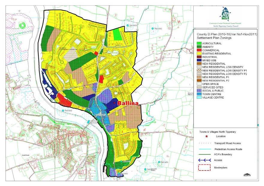
3 BALLINA SETTLEMENT PLAN 37
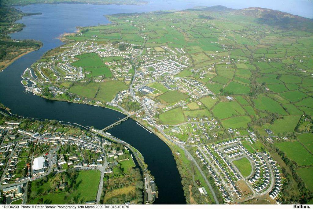
4 1.0 General Introduction and Development Context Location Ballina is located at the southern tip of Lough Derg on its eastern shore. The town is physically linked to Killaloe, Co Clare by a 13 arch stone bridge - Killaloe Bridge. The town is situated in a valley with the Arra Mountains rising to the north east. The R494 links the town to Birdhill and the M7. Population Having regard to its picturesque setting and proximity to Limerick, Ballina is a thriving town with an ever increasing population. In 1996 the CSO recorded a population of 598 in Ballina. This increased substantially to 1185 in 2002 and again in 2006 to The 10 year period between 1996 and 2006 resulted in an increase in population of over 300%. Settlement Form Ballina (and its sister town Killaloe) is steeped in the history, antiquities and traditions surrounding the last Irish High King, Brian Boru, the O Brien Clan and the bishops of Killaloe. In more recent history Ballina was an important location on the Shannon for Barges travelling to Dublin. Improvements in rail networks led to reduced reliance on inland waterways networks. However the need for railway transportation also fell out of favour and the lines were removed in the 1950s having fallen into disrepair. Due to its history and reliance on the Shannon for its development, Ballina has largely developed in a linear fashion along the shoreline of Lough Derg and the Shannon River with the town centre being focused around Killaloe Bridge. More recent development has taken place to the north of the historic town predominantly in the forms of residential dwellings. Heritage Ballina along with its twin town Killaloe has been designated a Heritage town. Heritage status is allocated to towns across Ireland that exhibit unique character in terms of architectural styles. These features in the towns have also been preserved through time. Ballina/Killaloe boasts a magnificent-arched bridge, which joins these two towns. The area is also known to have been home to Brian Boru, King of Ireland over a millennium ago. Today the towns share a visitor s centre, a Romanesque cathedral and a church as well as the ruins of an ancient Norman castle. Much of the historic streetscape is in Killaloe however, landmark heritage sites such as St. Lua s Church exist in Ballina. Killaloe and Ballina have a complimentary provision of services to meet this demand, with Killaloe providing historical and cultural attractions in the historic core and Ballina providing much of the open space and car parking on the Lough Derg shore. Tourism Ballina is a popular destination with the boating fraternity, tourists and locals. There is a newly rejuvenated tree lined Park along the riverbank, formerly the railway line. The park leads to temporary mooring facilities and shower/changing rooms. Additional moorings are provided north of the bridge with the Derg Marina catering for the leisure craft. The excellent boating facilities combine to make Killaloe/Ballina one of the best centres for water activity breaks in Ireland. 38
5 The village itself offers locals and tourists alike a range of services with first-class pubs and eateries along the main street and old quayside. There is also ample convenience and comparison shopping opportunities within the sister towns. The village offers the potential to further develop as a tourist destination and economic driver within the region. 2.0 Key Aim and Objectives The key aim of the settlement plan is to provide a framework for the development of residential, commercial and other appropriate development and to enhance the visual character and amenities of the village. Key Objectives To facilitate low density, high quality housing appropriate to the village location to ensure adequate critical mass to maintain/improve local service provision. To provide, maintain and enhance social, community and amenity facilities within the village. Promotion of Ballina as a tourism destination in North Tipperary and to facilitate and encourage the development of commercial and employment opportunities which are necessary in sustaining its tourism base. To work in coordination with Clare County Council to progress the development of Killaloe and Ballina as linked settlements. To encourage and support the provision of improved transportation infrastructure within Ballina including a second Shannon crossing and inner relief roads as necessary. To facilitate the provision of appropriate amenity areas as part of any new development to link to public thoroughfares or existing developments. Reinforce the attractive setting of Ballina which exists at present by permitting appropriate and sensitively designed new development. To support opportunities for commercial and employment facilities. Cater for a number of low density housing schemes, serviced sites developments and also commercial / employment generating development which is appropriate in terms of scale, use and location within the village. Consolidate development within the delineated village boundary in order to protect the area of high amenity within which the village is set. Foster the creation of a more coherent settlement, with adequate critical mass to maintain/improve local service provision. 3.0 Services and Social Infrastructure Water Supply The village is serviced by a public water supply. An upgrade to the existing public water supply is imminent. Waste Water Ballina town is serviced by a waste water treatment plant and public sewer. The existing sewage treatment plant has limited capacity and as such upgrade works may be required during the lifetime of the Plan. Notwithstanding that the amount of land zoned in the plan allows for growth in the town, normal planning development management practice is that proposals are assessed as regards capacity of services to cater for them and development would not be permitted unless adequate treatment can be assured. Any development proposed within the village will need to clearly demonstrate this as part of any planning application. 39

 would have provide beneficial connectivity between Cullenagh and Ballina Village Centre.")
6 Roads and Transport Infrastructure. Ballina is located at the junction of Regional Roads R494, R4963 and R463. There is a network of public footpaths and public lighting within the town along its main artery with a much more limited provision on secondary routes and residential areas. The walkway link to facilitate the construction of a pedestrian accessway linking Lower Lakeview Road to Marine Village Road adjoining the boundary of Cullenagh House and the Slate Quarry Housing development, (traversing the disused Quarry front embankment) would have provide beneficial connectivity between Cullenagh and Ballina Village Centre. Social and Community Infrastructure Ballina town is served by a primary school, Roman Catholic Church & graveyard, a number of public houses, eateries, coffee shops and restaurants, convenience and comparison shopping and professional services. The facilities provided in Ballina are supplemented by additional and similar such facilities in Killaloe. In addition to the obvious water related sporting activities on offer there are a number of sports facilities in Ballina. Ballina has a large GAA pitch located off the approach road to the town from Portroe and also a handball alley beyond the national school. A small public park is located on the Limerick road adjacent to the river, and recent rejuvenation works and the provision of mooring facilities aim to increase the use the accessibility of the park. 4.0 Architectural and Archaeological Heritage Ballina has a unique history dating back to the pre-christian era. A castle once situated in proximity to the bridge. While no evidence of the castle remains today the town has developed around this site. Significantly, Ballina and Killaloe were formerly the capital of Ireland, being home to Brian Boru, High King of Ireland. This colourful history coupled with its picturesque setting at the southern tip of Lough Derg a significant navigation channel in the 1800s, has resulted in Ballina/Killaloe being designated Heritage Town status. Significant buildings/structures within the village considered worthy of protection and other buildings/features of note in and around the village are illustrated below. Killaloe Bridge S 672 Church of our Lady and St Lua S


7 Lady Lansdown - Underwater Archaeology Traditional Buildings Lady Lansdown at Killaloe drawn by William Stokes 1840s 5.0 Natura 2000 Sites Given its location on the shores of Lough Derg, and the banks of the Shannon, Ballina town abuts Lough Derg NHA and SAC. Any development proposed within the village will need to clearly demonstrate as part of any planning application that no negative impact is caused to the Natura 2000 sites. 6.0 Key Messages for Ballina Amenity and Town Centre Improvements Objectives A1. Consolidate and develop a vibrant town centre through promoting the development of vacant and derelict sites for commercial/mixed uses complimentary to the expanding residential base. Such land is zoned to the east of Main St in the centre of the town. These derelict and vacant sites include a garage with petrol pumps, a cottage and an agricultural shed fronting the Main St and lands to the east of McKeoghs Supermarket and Hardware Store. A2. To protect existing access to back-lands in the town and support the redevelopment of land adjacent to the National School which will facilitate access to such lands. A3. To promote the development of recreational amenities particularly playing pitches (GAA, soccer and rugby) and tourist recreational facilities such as a public park in the town and particularly on lands zoned accordingly in conjunction with works as part of planning permissions granted is envisaged, to improve the amenities of the area. A4. To maintain and improve the amenity space around the swimming pool in accordance with the Lough Derg Study prepared by Tourism Development Resources in July,2001. A5. To preserve the existing public right-of-way that leads from the Main Street to the banks of the Shannon. A6. To seek the reopening of the eye of the arch-bridge so as to facilitate the free movement of the public along the banks of the river and particularly to facilitate movement from the car park of the swimming pool to the middle of Ballina. A7. To provide off street car parking facilities in the town centre as part of commercial/mixed use development on lands to the east of Main St. A8. Promote the provision of appropriately designed signage and nameplates in respect of established and new residential development in Ballina. A9. Promote the provision of a rescue centre and boathouse facility within the amenity area adjacent to the swimming pool. 41
8 A10. To preserve the existing public access to the recreational amenity provided by the Derg Marina. A11. Promote the retention of traditional buildings within the town core forming a streetscape A12. Protection of public vistas to and from Lough Derg and the River Shannon. Tourism Objectives TM1. Promotion of Ballina as a tourism destination in North Tipperary and to facilitate and encourage the development of commercial and employment opportunities which are necessary in sustaining its tourism base. Public Utilities P1. To support the implementation of Stage 2 of the Newport Water Scheme to serve Ballina and improve the existing water supply. P2. To upgrade the storm and foul water collection network in the town. P3. To support the under-grounding of all utility cables along Ballina s Main Street. P4. To provide a new graveyard and adequate ancillary car parking facilities within close proximity to the town. Transport and Access T1. To preserve the approach roads free from sporadic development and/or development that would have a negative impact on traffic safety or the carrying capacity of the road network. T2. To improve and provide public footpaths, traffic calming and lighting particularly on Quarry Lane, the western side of the Nenagh road and Grange road. T3. To seek the widening of the footpath network in the town and the construction of new footpaths on all routes between the perimeter and existing network as part of new development. T4. To provide road widening, footpaths, lighting and traffic calming measures on Quarry Lane. T5. To provide for adequate set down and off street car parking areas alongside the school as part of the development of the lands adjoining the school. T6. To encourage co-operation with public and private service providers in an effort to secure improvements in the public transportation system, serving the town T7. To address the traffic movement on the bridge and support the current study by Barry & Associates Consulting Engineers in the long term to identify a corridor for constructing a new river crossing downstream of the existing bridge. T8. To promote and provide for pedestrian access and walkways along the river bank. T9. To address the issue of pedestrian and cycle movement throughout the village with particular reference to ensuring linkage of footpaths and provision of crossing facilities between major residential areas and the National School. Housing H1. To limit development along the approach roads to Ballina so as to prevent town sprawl; H2. To ensure that residential development should be developed in a properly planned and coordinated manner in accordance with the zoning objectives of the settlement plan. H3. High quality designs, which are reflective of the existing rural character of the village, without precluding high quality innovative contemporary designs. H4. Improved public footpaths and lighting should be provided as part of all new developments Heritage HE1. To develop a heritage trail in the town, in cooperation with Killaloe which allows visitors and locals to appreciate and gain insight into the history and archaeology of the town 42
9 HE2. The Council will seek to ensure the protection of protected structures, historic buildings and buildings/structures of archaeological significance HE3. To ensure that developments which would be harmful to, or that would result in a significant deterioration of habitats and/or disturbance of species in a Natura 2000 site will be resisted. 7.0 Specific Development Objectives Proposals for development will be assessed in accordance with the policies and objectives of the, as set out in the main text in Volume 1. In addition to general policy requirements for development, the Council will seek to implement the following objectives: DA 1: Development Area 1 - Cullenagh This site shall provide for the consolidation and completion of Cullenagh on land zoned for lowdensity residential development and amenity as follows: 1. Set out an overall framework for the proper planning and sustainable development of the study area, through proposals for residentially zoned lands, and identification of lands required/suitable for recreational and leisure appropriate for master plan areas; 2. Provide for overall improvement in the visual amenity of the area through enhanced open space provision, landscaping, boundary treatment and development guidance; 3. Provide for the protection and enhancement of the shore line, and identify opportunities for lakeside development where such opportunities exist. 4. To provide for a park and play pitch located west of GAA pitch as part of new development; 5. It is intended that the completed development site would form the basis for completion of all necessary infrastructure, including water supply, sewerage, roads and lighting. 6. To seek a second master plan for the lands west and northwest of the existing GAA pitch to include proposed residential, low-density residential and amenity uses as shown on the zoning map. This plan shall take account of the Cullenagh Estate Master Plan and form part of the overall master plan for Cullenagh. 7. The Cullenagh Estate Master Plan has been commissioned by North Tipperary County Council to address the physical condition and appearance of existing housing land at Cullenagh with recommendations on the preferred way forward to the satisfaction of both the local residents and the new developer of the site. The main aim of the masterplan is to achieve an appropriate balance between the amount and type of new development while safeguarding the environmental quality and the amenity of existing residents. In addition, the shoreline is a particular sensitive area where future development needs to be carefully considered in relation to existing vegetation, views across Lough Derg, and the provision of suitable amenity space for the existing Cullenagh development. Outline proposals for the completion of each of these Detailed Areas, with development guidance where appropriate, are included on the Cullenagh Estate Master Plan. DA 2: Development Area 2 - McKeogh Lands East of Main Street and south of Grange Road: This development site will provide for mixed use development on land zoned for mixed use and social and public uses as follows: 1. Provide a link road between Grange Road and Ard Lua Road and an extension of the offstreet car park to the rear of McKeogh s supermarket. 43
10 2. To provide for an extension to the town centre, and therefore provide new streetscape along the main spine route. 3. To provide an extension to the primary school and improved off-street and set down parking. 4. To provide a park of 0.4 ha (1 acre) in area and within the overall master plan include footpaths, seating and planting. DA 3: Development Site 3 - Lands north of Lakeside Drive and South of Quarry Lane: This site shall provide for new land zoned for amenity, town centre and residential use as follows: 1. Mixed use commercial and residential development which incorporate a new civic square with community building. The overall development shall include an element of streetscape and which can be accessed from Lakeside Drive and Quarry Lane. 2. The development should ensure that a developed amenity space is provided as part of any commercial and/or residential development including recreational and leisure facilities within the overall development of this section of land 3. The development shall provide a through link between the Derg Road and Portroe Road. The proposed development should seek to share existing entrances or extend access from adjoining developed lands. 4. Seek the provision of car parking and bus parking adjacent to the river. DA 4: Development Site 4 Derg Marina Development of this site shall incorporate the submission of a masterplan to provide for mixed use development on land zoned as follows: 1. To provide for enhanced amenities to include improved public access. 2. The site can provide infrastructure supporting water and marina based activities as well as shore based activities. 3. The retention of boat servicing and provision for over wintering of boats. 4. It is a specific objective of the Council that any proposed development of this site shall be primarily for tourism related activities which are necessary in sustaining a strong tourism base. This shall include the provision of public berthage as part of any future development of the site. The Masterplan shall take into account the requirements of the SEA and Habitats Directives as appropriate. 5. Development will ensure that the integrity of the Special Protection Area (SPA), Special Area of Conservation (SAC) and proposed Natural Heritage Area (pnha) are protected. 6. Development will take place recognising the outcome of a comprehensive Flood Risk Assessment carried out by a suitably qualified person and through consultation with the OPW and/or with reference to the outcome of the Shannon Catchment Flood Risk and Management Study (Shannon CFRAM). DA 5: Development Site 5 - Grange Road The development of this site shall provide for mixed use development including residential, lowdensity residential, social and public use and amenity as follows: 1. To provide an access road that links the Grange Road to church via internal lands. 2. Provide for a play pitch / park area adjacent to low-density housing. 3. Provide for a future grave yard on lands to the north of the master plan area. 4. Provide for road widening along the existing lane within the master plan. 44
11 STAGE ONE FLOOD RISK ASSESSMENT - BALLINA 1.0 Introduction This is the Stage 1 Flood Risk Identification for Variation No. 1 of the 2010 (hereafter referred to as the Plan), prepared in accordance with the Planning System and Flood Risk Management Guidelines for Planning Authorities published by the Department of the Environment, Heritage and Local Government and the OPW in November The purpose of this process is to identify whether there may be any flooding or surface water management issues related to the plan area that may warrant further investigation through stage 2 and 3 Flood Risk Assessment. This stage 1 Flood Risk Assessment forms an integral part of the SEA process for Variation of the Plan and will inform the approach to future planning and development in North Tipperary. 2.0 Flood Risk Identification (Stage 1) The following sources of information have been investigated in order to determine flood risk potential; 1. OPW preliminary Flood Risk Assessment indicative fluvial flood maps. 2. Predictive and historic flood maps, and benefiting land maps, such as those at 3. Predicative flood maps produced under the CFRAM. 4. River Basin Management Plans and reports. 5. Indicative assessment of existing flood risk under preliminary flood risk assessment. 6. Expert advice from OPW 7. Consultation with local authority 8. Topographical maps. 9. GSI Alluvial deposit map. 10. Liable to flood markings on the old 6 inch maps. 11. Newspaper reports. 12. Consultation with Local Community 13. Walkover survey Each of these sources is addressed individually below: 1. OPW preliminary Flood Risk Assessment indicative fluvial flood maps. These are being produced through the catchment-based Flood Risk Assessment and Management Study. These maps are not yet available for the River Shannon Catchment. 2. Predictive and historic flood maps, and benefiting land maps, such as those at This website was consulted. It was found that there were a few flood events in the village of Ballina. The last recorded event was in 2004; prior to this there was a severe flood in the Winter 1999/2000, which included the flooding of the entire River Shannon catchment. There was also a flood event in 1994/95 and in Predicative flood maps produced under the CFRAM. The Shannon Catchment Flood Risk and Management Study (CFRAM) is to be commenced in 2010 and is scheduled to be completed by the end of Therefore the predicative flood maps to be prepared under this project are not yet available. 45
 is to be commenced in 2010 and is scheduled to be completed by the end of 2013.")
12 4. Catchment Flood Risk Assessment and Management Plans and reports. The Shannon Catchment Flood Risk and Management Study (CFRAM) is to be commenced in 2010 and is scheduled to be completed by the end of Therefore this Stage 1 Flood Risk Assessment has not been able to make reference to any guidance or information which may be contained within it. It is hoped that as part of the review of the Plan, to be completed by 2013 that this information will be available and can feed into the Assessment for the new Plan. 5. Indicative assessment of existing flood risk There is no river flowing through Ballina village, although it is situated along the banks of the River Shannon, at the southernmost tip of Lough Derg. The topography is such that the land falls from east to west at the southerly end of the Ballina. Moving north towards Cullenagh the land falls from north east to south west. The meeting point of these topographical areas gives rise to a narrow cleft of lowland where Alluvial soils are present. The most recent flood event took place in this area, Summerhill Road (R404), in The lowland areas situated on the banks of the River Shannon at the northern end of the town flooded in the winter of 1999/2000. This area lies at a substantially lower level to the town itself. 6. Expert advice from OPW This Stage 1 Flood Risk has been undertaken with the advantage of expert advice from the OPW. 7. Consultation with local authority A site visit was undertaken and planning histories consulted. Flood risk assessments were required on 2008 planning application 08/51/ Topographical maps. County Topographical maps do not adequately address the local Ballina area as they are based on the topography of the county. 9. GSI Alluvial deposit map. GSI Soils Map for Ballina 46
13 The GSI Soils map is set out above for Ballina. The turquoise area indicates lands which are manmade. The red area represents that area where Acid Brown Earths Brown Podzolics soils are in existence. The yellow/mustard area highlights where Alluvium soils are present and is indicative of an area which is prone to flooding. Alluvial soil mapping alone is not a definitive gauge of areas at flood risk, however, it a useful indicator of areas where flood events have occurred historically. The GSI Soils Map has informed the Land Use Zoning Map. 10. Liable to flood markings on the old 6 inch maps. None of the lands within the village or adjacent to the river, within the settlement boundary have been identified on the 6 maps as being liable to flooding. A Ford is indicated in the Roolagh area of Ballina. 11. Newspaper reports The Newspaper Reports available at were consulted as part of this Stage 1 Flood Risk Assessment. There was no record of reports of flooding in the village. 12. Consultation with local people. Consideration will be given to any comments received during the public consultation phase on the 2010 Development Plan variation that relate to flooding in the area. 13. Walkover survey to assess potential sources of flooding. A number of inspections were carried out on site by the Planning Officer during the preparation of the Variation. 3.0 Conclusion This is the Stage 1 Flood risk assessment for Variation No. 1 to the The Planning Authority is satisfied that there is no potential flood risk identified in areas planned for growth in Ballina based on an assessment of all the sources listed above and bearing in mind a precautionary approach. This report should be read in conjunction with the SEA and HDA Report documentation as part of the variation process. It is concluded that there will be no significant flood risk to the Plan area and any surrounding areas as a result of Variation No. 1 to the
14
15

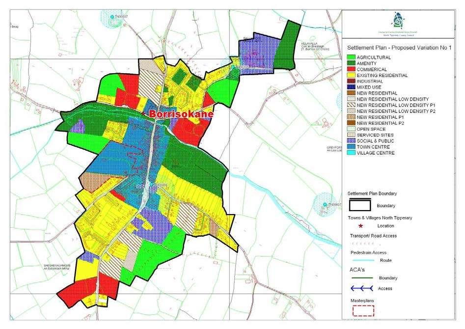
16 1.0 General Introduction and Development Context Location Borrisokane is located 15km north of Nenagh on the N52. While the town is primarily residential, it acts as a market town for services, being conveniently located in relation to the major towns of Nenagh and Roscrea, and amenities such as Lough Derg. provide for employment uses, retail and general warehousing, and expansion of the existing nursing/ retirement home. Population The population fell from 850 in 1996 to 823 in 2002 (CSO) which was a decline of 2.1% in the census period. It has remained at 823 in 2006 (CSO). The town has a current imbalance between social and private housing, previously the majority of housing developments have been completed by the County Council in the form of social housing. However, there has been some private development under the last. It is, therefore, imperative that the current situation continues through the provision of private and affordable housing to ensure that the town has a healthy mix of private, affordable and social housing. It will therefore, be important that a range of housing types are proposed as part of new housing schemes. This should include low-density housing on large sites to provide an alternative to one-off housing in rural locations. Settlement Form Borrisokane is situated in an area dominated by agriculture, lying in a bowl-shaped syncline. The town itself rises towards the north and south with important buildings, such as the Catholic Church, the Terrace and AIB bank located in prominent positions. The town is intersected by the Ballyfinboy River. There is a strong historic legacy evident in the town, and many of the key architectural elements that give the town its character are still intact. There is an existing employment area west of Shannon Street in the form of a small Shannon Development Park and Minch Norton Grain yards. The land-use zoning map provides for the expansion of the Shannon Development site. It is important that serviced and affordable lands are made available for small start up industries that are currently setting up in the rural areas around the town. Secondly, lands have been zoned on the Nenagh Road for commercial development. This would. 2.0 Key Aim and Objectives The town is designated as a Secondary Service Area/Market Town in Population and Settlement Strategy Chapter of the Plan. The key aim of the settlement is to provide a framework for development for appropriate residential, commercial and industrial development and to enhance the visual character and amenities of the town. Key Objectives To facilitate low density, high quality housing appropriate to the town location, To maintain and enhance social, community and amenity facilities within the town. To support opportunities for commercial, industrial and other employment facilities. To focus development within the development boundary of the settlement 3.0 Services and Social Infrastructure Water Supply The settlement is serviced by a public water supply. Waste Water The settlement is serviced by a public sewer. Notwithstanding that the amount of land zoned in the plan allows for growth in the town, normal planning development management practice is that proposals are assessed as regards capacity of services to cater for them and development would not be permitted unless adequate treatment can be assured. Any development proposed within the town will need to clearly demonstrate this as part of any planning application.
 branch to the west from the settlement.")
17 Roads and Transport Infrastructure Borrisokane is located on the National Secondary Road (N52 Birr) and the N65 Galway route. The Regional Road R490 to Cloughjordan is located at the southern side of the settlement and Local Roads (L-1100 and L-1092) branch to the west from the settlement. Other significant historical sites within the town include; David Clarke Memorial Hall (Protected Structure No. S421) on Mill Street, built c Old Church Centre (Protected Structure No. S422) again on Mill Street is a detached cruciform-plan gable-fronted former church, completed There is an extensive network of footpaths within the area. Public lighting is provided throughout the settlement. Social and Community Infrastructure A Roman Catholic Church, Church of Ireland Church, national and secondary schools, GAA grounds, community centres and play area, numerous public houses, guesthouses, restaurants, a court house and take-aways and a post office are currently located within the settlement. 4.0 Architectural and Archaeological Heritage There are a number of significant historical sites within the town. Among its attractions include Borrisokane Courthouse and Community College which are located in a detached former workhouse complex, built c. 1850, comprising four two- and three-storey blocks having large courtyards between and two single-storey buildings. The Methodist Chapel (Protected Structure No. S417) on Main Street The Borrisokane Church of Ireland on Main Street is a single-cell Board of First Fruits church, built in 1812 See the Record of Protected Sructures for full list of Protected Structures in the County Development Plan as set out in the main text in Volume III. Conservation Area This includes all of Main Street, part of South Main Street, part of Mil Street and part tower Hill and Shannon Street. Archaeological Heritage Recorded Monuments TI Settlement Possible and TI Church Site and Graveyard are both located around the junction of the Cloughjordan Road and Main Street. 5.0 Key Messages for Borrisokane The settlement shall be developed in a properly planned and coherent manner. The picturesque setting shall be retained and enhanced in accordance with appropriately designed and sensitive development. The conservation and integration into new development of existing stone walls, trees and native hedgerows, and promotion of similar materials for new boundaries. High quality designs, which are particularly reflective of the predominantly rural character of the area, without precluding high quality innovative contemporary designs. Promotion of natural building and boundary materials.


18 The conservation and protection of protected structures, recorded monuments and other features of archaeological and historical merit within the settlement. 6.0 General Development Objectives Proposals for development will be assessed in accordance with the policies and objectives of the as set out in the main text in Volume I. Ion addition to general policy requirements for development, the Council will seek to implement the following objectives: Facilitate people to live in high quality, primarily low density housing in a rural town location. Maintain services at a local level. Reinforce the attractive rural town which exists at present by permitting appropriate and sensitively designed new development. Facilitate the creation of commercial, industrial and other employment opportunities. The rate of growth must be in accordance with the Council s policy on towns and villages and the availability of services (including physical and social provisions). To provide a new streetscape as part of redevelopment of current playing fields. To provide a park as part of new residential development on lands south of Cloughjordan Road. To provide a river side walk and park as follows; (1) Maintain link from Main Street east along river, (2) maintain right of way from Mill Street through Opportunity site C, develop the land between the river and stream to the rear of the Old Church Centre as park with footbridge access, and to provide a riverside park to north of GAA field as part of new residential development which would be subject to a flood risk assessment. To seek the undergrounding of Cables and wirescape on Main Street. To seek the protection of the architectural conservation area, particularly elements such as coach arches. To seek the protection of trees at the following locations: i. Hardwood trees north and south along Mill Road. ii. Beech trees on southern approach road and west of The Terrace. To reserve land for a future link road between N65 and N52 to the north east of the town. To provide a cycle track on the access road to the Community College. To ensure that proposals for new development of lands adjacent to public roads provides access to backlands and land that does not have road frontage. To provide pedestrian linkage as part of new town centre development. To seek the redevelopment of derelict and vacant dwelling and sheds to town centre uses. To seek the redevelopment of this riverside site to provide town centre uses that include new streetscape on Mill Street, off-street parking, preservation of the Georgian house and retention of the right of way through the northern part of the site to the river and land north of the river. To provide new town centre development on land off Shannon Street that is currently occupied by derelict limestone buildings. New development may provide for the restoration of the limestone buildings, or the reuse of the stone and arches. Restoration of derelict building to town centre uses.

19
20
21 1.0 General Introduction and Development Context Location Borrisoleigh is situated on the R-498 between Thurles and Nenagh and is intersected on the northern side of the town by the Clodagh River. Population The population of the town grew between 1996 and 2002 from 564 persons to 598 persons, which is a 6% increase in population in the period and this rose to 626 in 2006 CSO figures, a further increase of 4.7%. Settlement Form The town is situated in a high quality landscape area, lying in a bowl-shaped syncline north east of the Silvermines and Slievefelim Mountains. The town itself rises towards the north and south, with important buildings, such as the renaissance Catholic Church, located in prominent positions. The town centre has a linear pattern with junctions with Pallas Street and Chapel Street. The church dominates the central area with some good examples of Irish Victorian architecture in Finn s pub and Chadwick s shop. The town is the home of Tipperary Natural Mineral Water which is a nationally and internationally recognised brand and is a large employer in the town and occupies a significant area. 2.0 Key aim and objectives Borrisoleigh has been identified as being a Secondary Service Areas / Market Town in Chapter 3 of the. The key aim of this settlement plan is to provide a framework for the development for appropriate residential, commercial and industrial development, to enhance the visual character and amenities of the town and to ensure that Borrisoleigh provides the services and facilities for its hinterland. Key Objectives To facilitate low density, high quality housing appropriate to the town and its designation as a Secondary Service Areas / Market Town on the Settlement Hierarchy in Chapter 3 of the Plan. To maintain and enhance social, community and amenity facilities within the town. To support opportunities for commercial, industrial and other employment facilities. To focus development within the development boundary of the settlement. 3.0 Services and Social Infrastructure Water Supply The settlement is serviced by a public water supply. Waste Water The settlement is serviced by a waste water treatment plant and public sewer. Upgrade works may be required during the lifetime of the Plan. Notwithstanding that the amount of land zoned in the plan allows for growth in the town, normal planning development management practice is that proposals are assessed as regards capacity of services to cater for them and development would not be permitted unless adequate treatment can be assured. Any development proposed

22 within the town will need to clearly demonstrate this as part of any planning application. Roads and Transport Infrastructure Borrisoleigh is situated on the R498 and R501, conveniently located in relation to the major towns of Thurles, Nenagh and the City of Limerick. There is an extensive network of footpaths within the area. Public lighting is provided throughout the settlement. Social and Community Infrastructure A Roman Catholic Church, primary and secondary schools, Town Park with GAA pitch, soccer pitch, tennis courts pavilion and play ground, public houses, shops, butchers, hairdressers, chemists, guesthouses, take-away, bank, bakery, restaurant and a post office are currently located within the settlement providing for the immediate needs of those living within the hinterland of the town. 4.0 Architectural and Archaeological Heritage There are a number of significant historical sites within the town. Among its attractions are some traditional shop fronts, and a 15th century tower house. An inscribed slab inserted into the gable of one of a pair of red sandstone houses are engraved the names Richard Burke and Ellis Hurley, Walter Doolin was the architect of the church in McDonagh Square. The window and door surrounds were quarried at Drombane, 12 miles away. It is similar to the stone used in Cormacs Chapel, Cashel. Conservation Area This includes all of Main Street, northern part of Pallas Street, part of Chapel Street and Lower Street. Protected Structures See RPS for list of Protected Structures in the as set out in the main text in Volume III. 5.0 Key Messages for Borrisoleigh The settlement shall be developed in a properly planned and coherent manner. The picturesque setting shall be retained and enhanced in accordance with appropriately designed and sensitive development. The conservation and integration into new development of existing stone walls, trees and native hedgerows, and promotion of similar materials for new boundaries. High quality designs, which are particularly reflective of the predominantly rural character of the area, without precluding high quality innovative contemporary designs. Promotion of natural building and boundary materials. The conservation and protection of protected structures, recorded monuments and other features of

23 archaeological and historical merit within the settlement. 6.0 General Development Objectives Proposals for development will be assessed in accordance with the policies and objectives of the as set out in the main text in Volume I. In addition to general policy requirements for development, the Council will seek to implement the following objectives: Facilitate people to live in high quality, primarily low density housing in a rural town location. Maintain services at a local level. Reinforce the attractive rural town which exists at present by permitting appropriate and sensitively designed new development. Facilitate the creation of retail, commercial, industrial and other employment opportunities. The rate of growth must be in accordance with the Council s policy on towns and villages and the availability of services (including physical and social provisions). Specific Objectives 1. To create an Inner Relief Road as part of future development to link the R498 on the western side of the town with the Templemore Road (R501). 2. To seek the restoration of a number of derelict or vacant sites in the town. 3. To protect existing access to backlands and to support the redevelopment of Main Street properties as part of the development of backlands. Such lands include lands south of Main Street, to the rear of Old School and Council Car Park and lands south of Main Street to the rear of Garda Station. 4. To provide suitable and accessible land for commercial development. A prominent site is zoned on the Thurles Road, south of the Sewerage Treatment Plant, for such use to attract uses that heretofore have been developed in rural locations along the R To preserve the Local Road L-3215 to the north of the town free from sporadic development and/or development that would have a negative impact on the setting of the town. 6. To seek to implement a town improvement scheme which would include the under-grounding of cables and wirescape within the town, the improvement of pavement quality and the introduction of landscaping into the town where possible. 7. To seek to provide traffic calming on approach roads into the town where resources permit. 8. To seek to improvement junctions within the town as resources permit. 9. To seek that the proposed linear park along the river provides adequate pedestrian walkways and access to the river where possible. 10. To seek the provision of an amenity area in Borrisland North to be developed as part of new developments with seating/picnic area/play area/skate board park etc.
24
25
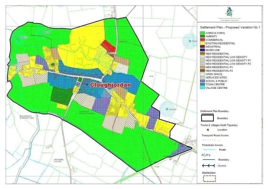
26 1.0 General Introduction and Development Context Location The market town of Cloughjordan lies close to the border with Offaly at the junction of the R490 and R491 Regional Roads. The town serves an area which is renowned for the quality of its agricultural land and the food it produces. While the town is primarily residential in nature, it acts as a local centre for services and facilities. Population The population fell from 447 in 1996 to 431 in 2002 (CSO) which is decline of 3.6% in the census period. There has been a further decline to 394 in the 2006 Census (CSO, 2006). Settlement Form The Ballyfinboy River intersects the town. The town has a strong historic legacy, and many of the key architectural elements that give the town its character are still intact. Important landmark buildings in the town include the three churches and the Rail Station. The town of Cloughjordan remained relatively unchanged during the Celtic Tiger years with limited investment in employment, retail development, or necessary medium or large-scale commercial or industrial development. What is evident from the population figures is that the town has suffered from an outflow of population to the rural countryside and the larger towns. Much of the private housing in the town is on stand alone sites, with a few new private estates having been constructed. It is important that this continues through the provision of private and affordable housing to ensure that the town has a healthy mix of private, affordable and social housing. It will therefore, be important that a range of housing types is proposed as part of new housing schemes. This should include low-density housing on large sites to provide an alternative to one-off housing in rural locations. One of the most important developments in Cloughjordan in recent years has been the progress on Ireland s first Eco-Village. The concept of this innovative and unique proposal, to develop a community with commitments to ecological, social and economic sustainability within a urban environment, has been recognised nationally and internally, as being an important pilot for the way future communities might develop. This new community, being developed on 67 acres (c.27ha) of farmland, will merge with the existing village of Cloughjordan through a new street opposite the Church of Ireland. The development of the Eco-village will provide a welcomed inflow of people into the town and has developed Cloughjordan s image as an eco-town. The town of Cloughjordan consists of one main street, with three branching side streets. Halfway down Main Street, is the Church Meadow or Town Green, bordered by a stone wall and mature lime trees; setting the stage for St. Kieran s Churchy of Ireland church, built in To the left of the church are the Militia Houses, reputed to have been built as a nineteenth century army barracks, but never used as such. To the right is the modern St. Kieran s hall, standing on the site of the first purpose-built school in the town. The Methodist Church, built in 1875 is on Main Street, while on Templemore Road, the Catholic Church of SS Michael and John, built in 1899, creates a dramatic vista at that entrance to the town. The oldest and most historically significant
27 domestic building in the town, Cloughjordan House, is situated on the Shinrone Road. To continue to develop the concept of Cloughjordan being a Eco-town. 2.0 Key aim and objectives Cloughjordan is identified as being a District Service Centre in Chapter 3 of the. The key aim of this settlement plan is to provide a framework for the development for appropriate residential commercial and light industrial development, to enhance the visual character and amenities of the village and to ensure that Cloughjordan provides the services and facilities for its hinterland. Key Objectives To facilitate low density, high quality housing appropriate to the town and its designation as a District Service Centre on the Settlement Hierarchy in Chapter 3 of the Plan. To maintain and enhance social, community and amenity facilities within the village. To support opportunities for commercial and employment facilities. To focus development within the development boundary of the settlement. 3.0 Services and Social Infrastructure Water Supply The village is serviced by a public water supply. Waste Water The village is serviced by a sewage treatment plant. However, up-grade works may be required to cater for additional development. Roads and Transport Infrastructure Cloughjordan developed at the intersection of travel routes between Nenagh, Birr and Moneygall. It is a district service town located 16km north of Nenagh on the R491. It is conveniently located in relation to the major towns of Nenagh, Roscrea, Birr and Borrisokane. Cloughjordan railway station opened on 5 October It is connected to the Irish railway network on a branch from Limerick to Ballybrophy (where it joins the main Cork Dublin line) and has a twice-daily service in each direction. There is an extensive network of footpaths within the area. Public lighting is provided throughout the settlement.
28 Social and Community Infrastructure The town has a broad main street, with a tree-lined square at its mid-point. Main Street is lined by an attractive mix of houses and shops, including a post office, a Garda station, a library, ten shops (including a book/coffee shop, a butcher with his own farm, a pharmacy and a cycle shop), a garage, a restaurant, four pubs, a 'chipper', a fire station, sports clubs, two surgeries, two schools, three churches (Catholic, Methodist and Church of Ireland) and GAA grounds. 4.0 Key Messages for Cloughjordan The settlement should be developed in a properly planned and co-ordinated manner in accordance with the zoning objectives of the settlement plan. The picturesque setting shall be retained and enhanced in accordance with appropriately designed and sensitive development. Low density rural clustered style development is promoted on residential zoned sites. The provision of additional passive amenity spaces including playground facilities should be provided. High quality designs, which are particularly reflective of the predominantly rural character of the area, without precluding high quality innovative contemporary designs. The conservation and protection of protected structures, recorded monuments and other features of archaeological and historical merit within the settlement. The conservation and integration into new development of existing stone walls, trees and native hedgerows, and promotion of similar materials for new boundaries. 5.0 General Development Objectives Proposals for development will be assessed in accordance with the policies and objectives of the County Development Plan, as set out in the main text in Volume 1. In addition to general policy requirements for development, the Council will seek to implement the following objectives: The Council will seek to make provision and/or facilitate the provision of footpaths and public lighting to enhance the local infrastructure. The Council will seek to foster a village identity and definition of the village by facilitating the provision of hard and soft landscaping and signage. The Council will seek to ensure the protection of Protected Structures and archaeological monument (i.e by preservation in situ or at a minimum protection by record). The Council will seek to control ribbon development on the approach roads to preserve and consolidate the built environment of the village. The Council will seek to ensure hedgerows, trees and any natural stone walls are preserved and maintained in any new development proposals. The Council will seek to continue to improve the approach roads to the village and improve traffic calming. The Council will seek to ensure that development is focused
29 within the village around the core area so as to consolidate the centre of the village. To provide a new streetscape in the centre of the town on vacant and derelict sites. To provide a park as part of the planned village expansion north of Cloughjordan. To protect and provide access to back lands on the Station Road and to lands north and south of Main Street. To seek the undergrounding of cables and wirescape on Main Street. To seek the protection of the architectural conservation area, particularly elements such as coach arches. To seek the protection of stone boundary walls on the Borrisokane approach road, the Birr approach road and within the Conservation Area. To seek the protection of trees at the following locations: o Hardwood trees on the Birr Road. o Trees within the grounds of protected structures. 5.1 Transport and Access Improvement Objectives To reserve land for a future link road between R491 and R490 to the south east of the town. To provide extended footpaths as part of new development. To ensure that proposals for new development of lands adjacent to public roads provides access to backlands and land that does not have road frontage. To preserve rights of way. To provide pedestrian linkage as part of new town centre development. 6.0 Conservation Area: This includes most of Main Street, part of South Main Street, part of Station Road (see map attached) 7.0 See RPS (Volume III) for list of Protected Structures
30
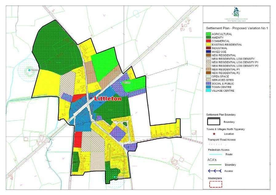
31 1.0 General Introduction and Development Context Location Littleton is located c. 5km southeast of Thurles on the former National Primary Road (N8) now re-classified as a regional road R639. Population Littleton village had a recorded population of 463 persons in 2006, which represented a decline of 37 people over the inter-censal period(cso, 2006). Settlement Form The core of Littleton is defined by a traditional main street along the old N8. Residential development has expanded particularly to the south by the construction of a number of local authority housing estates. 2.0 Key aim and objectives Littleton is a designated local service centre under the settlement hierarchy as set out in Chapter 3 of the Draft Development Plan. Therefore the settlement has a key role in terms of service provision both for the village and its surrounding rural hinterland. The key aim of the settlement plan is provide a land use framework to promote the expansion of residential, employment, social and community service provision. Key Objectives To support the vitality and viability of the village through the promotion of the commercial and local service facilities to service the settlement and its hinterland. To encourage new residential owner occupied developments to provide a greater socio-economic mix in the settlement. To maintain and enhance social, community and amenity facilities within the village. To support opportunities for commercial and employment provision. 3.0 Services and Social Infrastructure Water Supply The village is serviced by a public water supply. Waste Water The village is served by a waste water treatment plant. Roads and Transport Infrastructure Littleton is served by a excellent road network, linked by the former national primary road to Thurles and in close proximity to the new M8. Traffic calming has taken place on the boundary of the village along the R639
 There is an extensive network of public footpaths in the area. Public lighting is provided throughout the settlement.")

32 which has created defined entrances to the village. These entrances are formed by large signs, and thus an opportunity is provided to enhance the character of the village through soft landscaping. Townhouse (S872) There is an extensive network of public footpaths in the area. Public lighting is provided throughout the settlement. Social and Community Infrastructure The village centre provides a selection of services such as retail shops, public houses, post office, garage, school and church. 4.0 Architectural and Archaeological Heritage Littleton has a number of buildings of architectural significance including the Chruch of Ireland church, which was built c and is protected under the. Buildings which are proposed for protection includes an early 19 th century townhouse, which occupies a corner site on the main streetscape. Church of Ireland Church (S260) There are a number of recorded monuments within in the settlement boundary, which include a Ringfort to the south of the village and a Tower House to the east. 5.0 Key Messages for Littleton The settlement should be developed in a properly planned and co-ordinated manner in accordance with the zoning objectives of the settlement plan. Commercial and enterprise development is encouraged within the settlement boundary to expand the service provision and employment base for local residents. Low density rural clustered style development, which incorporates detached houses and serviced site are promoted. The development of infill sites and under-utilised sites within the village is encouraged. 6.0 General Development Objectives
33 Proposals for development will be assessed in accordance with the policies and objectives of the County Development Plan, as set out in the main text in Volume 1. In addition to general policy requirements for development, the Council will seek to implement the following objectives: The Council will seek to make provision and/or facilitate the provision of footpaths and public lighting to enhance the local infrastructure. The Council will seek to enhance the village identity and traffic safety through the facilitation of additional traffic calming including hard and soft landscaping. The Council will seek to ensure the protection of the protected structures and archaeological monuments (i.e by preservation in situ or at a minimum protection by record). The Council will seek to control ribbon development on the approach roads to preserve and consolidate the built environment of the village. The Council will seek to ensure hedgerows, trees and any natural stone walls are preserved and maintained in any new development proposals.

34 Newport Local Area Plan 2010 Context Newport is identified as Service Centre in the (as varied). Newport has a dedicated Local Area Plan Newport LAP 2010, this should be referred to for further detail. Development Objectives Please refer to the detailed development objectives as set out in the Newport LAP 2010 and any amendments thereto during the life of the (as varied).
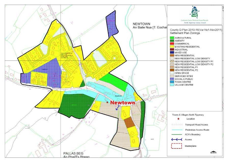
35 NEWTOWN SETTLEMENT PLAN 78
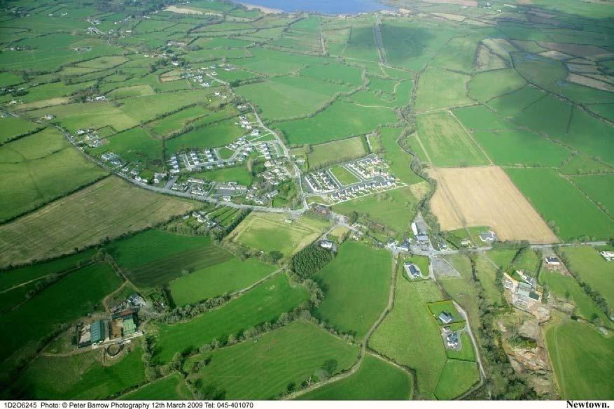
36 1.0 General Introduction and Development Context Location Newtown village is located on the Regional Road R494 approximately 6km west of Nenagh town. The Newtown River runs in a northerly direction through the village before entering Youghal Bay and Lough Derg Population Although the core of the village is quite compact, Newtown extends over a much larger area. During the period between 2002 and 2006 the population of the Youghalarra DED (within which Newtown is located) grew by 40% from 626 people to 877 people. Settlement Form The original settlement is likely to have developed as a small cluster between the river and the junction. Subsequent expansion has in the main, taken the form of linear development along the constituent roads. The settlement is low rise and low density, with a number of different building styles in evidence, although the original core has a slightly tighter grain and more vernacular style. 2.0 Key Aim and Objectives The key aim of the settlement plan is to provide a framework for the development of residential, commercial and other appropriate development and to enhance the visual character and amenities of the village. Key Objectives To facilitate low density, high quality housing appropriate to the village location to ensure adequate critical mass to maintain/improve local service provision. To provide, maintain and enhance social, community and amenity facilities within the village. Reinforce the attractive rural village which exists at present by permitting appropriate and sensitively designed new development. To support opportunities for commercial and employment facilities. Cater for a number of small in-depth housing schemes, serviced sites developments and also commercial / employment generating development which is appropriate in terms of scale, use and location within the village. Consolidate development within the delineated village boundary in order to protect the area of high amenity within which the village is set. Foster the creation of a more coherent settlement, with adequate critical mass to maintain/improve local service provision. 3.0 Services and Social Infrastructure Water Supply The village is serviced by a public water supply. Waste Water The settlement is serviced by a waste water treatment plant and public sewer. The existing sewage treatment plant has limited capacity and as such upgrade works may be required during the lifetime of the Plan. Notwithstanding that the amount of land zoned in the plan allows for growth in the town, normal planning development management practice is that proposals are assessed as regards capacity of services to cater for them and development would not be 79


37 permitted unless adequate treatment can be assured. Any development proposed within the village will need to clearly demonstrate this as part of any planning application. Roads and Transport Infrastructure. Newtown is located on the Regional Road R494 with some recent development taking place on the L-6052 road to Youghal Harbour and Quay. There is a limited network of public footpaths and public lighting within the village. Social and Community Infrastructure The village is served by two public houses, a primary school, Roman Catholic Church, post office and a childcare facility. The local sports club have a playing field within the village boundary. 4.0Architectural and Archaeological Heritage There are a number of historic buildings and sites within the village boundaries. Significant buildings within the village considered worthy of note in and around the village are illustrated below. Former National School 5.0 Key Messages for Newtown Newtown R.C. Chapel Vernacular House The settlement should be developed in a properly planned and co-ordinated manner in accordance with the zoning objectives of the settlement plan. 80
38 Low density rural clustered style development is promoted on residential zoned sites. Promotion of low-density linear or clustered style development within the village, with the exception of slightly tighter knit development in the core. Facilitate and encourage the development of commercial and employment opportunities which are necessary in sustaining its tourism base. Encourage the use of natural building and boundary materials. The conservation and integration into new development of existing stone walls, trees and native hedgerows, and promotion of similar materials for new boundaries. High quality designs, which are reflective of the existing rural character of the village, without precluding high quality innovative contemporary designs. New development should recognise any existing outlying developments/ permissions with a view to linking up and therefore consolidating them back into the village fabric in a sensitive and coherent manner. Improved road alignment, public footpaths and lighting should be provided as part of all new developments. 6.0 General Development Objectives Proposals for development will be assessed in accordance with the policies and objectives of the, as set out in the main text in Volume 1. In addition to general policy requirements for development, the Council will seek to implement the following objectives: The Council will seek to improve and extend the provision of footpaths and public lighting to enhance the local infrastructure. The Council will seek to foster a village identity and definition of the village by facilitating the provision of hard and soft landscaping and signage. A traditional streetscape which maintains where possible the front boundary wall and trees. The Council will seek to ensure hedgerows, trees and any natural stone walls are preserved and maintained in any new development proposals. Promotion of low-density linear or clustered style development within the village, with the exception of slightly tighter knit development in the core. Buildings which respect the scale, massing and design of existing buildings in the village. The Council will seek to ensure the protection of protected structures, historic buildings and buildings/structures of archaeological significance. The Council will seek to control ribbon development on the approach roads to preserve and consolidate the built environment of the village. Enhancement of gateway features and natural edges as the opportunities arise, so as to increase the sense of place and character of the village. Access points to be provided where necessary, within the proposed development boundary. The incremental provision of footpaths through development contributions / special development contributions or requirements for works as part of planning permissions granted is envisaged, to improve the amenities of the area. 81
39 STAGE ONE FLOOD RISK ASSESSMENT - NEWTOWN 1.0 Introduction This is the Stage 1 Flood Risk Identification for Variation No. 1 of the 2010 (hereafter referred to as the Plan), prepared in accordance with the Planning System and Flood Risk Management Guidelines for Planning Authorities published by the Department of the Environment, Heritage and Local Government and the OPW in November The purpose of this process is to identify whether there may be any flooding or surface water management issues related to the plan area that may warrant further investigation through stage 2 and 3 Flood Risk Assessment. This stage 1 Flood Risk Assessment forms an integral part of the SEA process for Variation of the Plan and will inform the approach to future planning and development in North Tipperary. 2.0 Flood Risk Identification (Stage 1) The following sources of information have been investigated in order to determine flood risk potential; 1. OPW preliminary Flood Risk Assessment indicative fluvial flood maps. 2. Predictive and historic flood maps, and benefiting land maps, such as those at 3. Predicative flood maps produced under the CFRAM. 4. River Basin Management Plans and reports. 5. Indicative assessment of existing flood risk under preliminary flood risk assessment. 6. Expert advice from OPW 7. Consultation with local authority 8. Topographical maps. 9. GSI Alluvial deposit map. 10. Liable to flood markings on the old 6 inch maps. 11. Newspaper reports. 12. Consultation with Local Community 13. Walkover survey Each of these sources is addressed individually below: 1. OPW preliminary Flood Risk Assessment indicative fluvial flood maps. These are being produced through the catchment-based Flood Risk Assessment and Management Study. These maps are not yet available for the River Shannon Catchment. 2. Predictive and historic flood maps, and benefiting land maps, such as those at This website was consulted. It was found that in 2006 the Area Engineer with North Tipperary County Council identified Newtown as an area prone to flooding. A recurring flood event has been recorded as a result of runoff from hills after heavy rain. 3. Predicative flood maps produced under the CFRAM. The Shannon Catchment Flood Risk and Management Study (CFRAM) is to be commenced in 2010 and is scheduled to be completed by the end of Therefore the predicative flood maps to be prepared under this project are not yet available. 82
 is to be commenced in 2010 and is scheduled to be completed by the end of 2013.")
40 4. Catchment Flood Risk Assessment and Management Plans and reports. The Shannon Catchment Flood Risk and Management Study (CFRAM) is to be commenced in 2010 and is scheduled to be completed by the end of Therefore this Stage 1 Flood Risk Assessment has not been able to make reference to any guidance or information which may be contained within it. It is hoped that as part of the review of the Plan, to be completed by 2013 that this information will be available and can feed into the Assessment for the new Plan. 5. Indicative assessment of existing flood risk The Newtown River bisects the village of Newtown and empties into Youghal Bay. The topography is such that the land falls from south-west to north-east towards the river basin. 6. Expert advice from OPW This Stage 1 Flood Risk has been undertaken with the advantage of expert advice from the OPW. 7. Consultation with local authority A site visit was undertaken and planning histories consulted. A recurring flood event was recorded in 2006 as a result of runoff from hills after heavy rain. 8. Topographical maps. County Topographical maps indicate that Newtown is situated on lands inclining south-west to north-east towards the Newtown River basin. 9. GSI Alluvial deposit map. GSI Soils Map for Newtown The GSI Soils map is set out above for Newtown. The red area represents where Acid Brown Earths Brown Podzolics soils are in existence. The yellow/mustard area highlights where Alluvium soils are present and is indicative of an area which is prone to flooding. Alluvial soil 83
41 mapping alone is not a definitive gauge of areas at flood risk, however, it a useful indicator of areas where flood events have occurred historically. The GSI Soils Map has informed the Land Use Zoning Map and areas which are potentially liable to flooding have been zoned for amenity uses (save where they have already been developed). 10. Liable to flood markings on the old 6 inch maps. None of the lands within the village or adjacent to the river, within the settlement boundary have been identified on the 6 maps as being liable to flooding. 11. Newspaper reports The Newspaper Reports available at were consulted as part of this Stage 1 Flood Risk Assessment. There was no record of reports of flooding in the village. 12. Consultation with local people. Consideration will be given to any comments received during the public consultation phase on the Development Plan that relate to flooding in the area. 13. Walkover survey to assess potential sources of flooding. A number of inspections were carried out on site by the Planning Officer during the preparation of the Variation. 3.0 Conclusion This is the Stage 1 Flood risk assessment for Variation No. 1 to the The Planning Authority is satisfied that there is no potential flood risk identified in areas planned for growth in Newtown based on an assessment of all the sources listed above and bearing in mind a precautionary approach. Having regard for the recurring flood event which has been recorded by the OPW in Newtown, any applications for future development of lands adjacent to the Newtown River will be accompanied by a comprehensive flood risk assessment. This report should be read in conjunction with the SEA and HDA documentation prepared as part of the variation process. It is concluded that there will be no significant flood risk to the Plan area and any surrounding areas as a result of Variation No. 1 to the
42 PORTROE SETTLEMENT PLAN 85
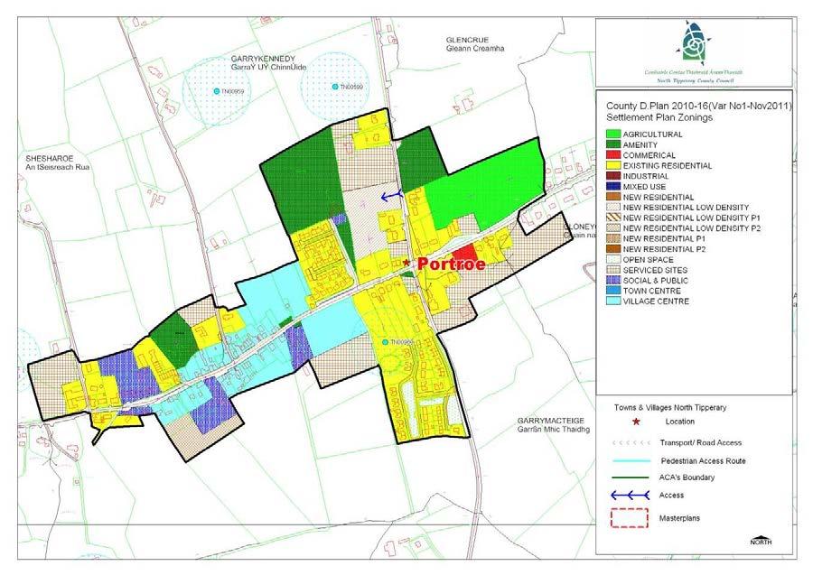
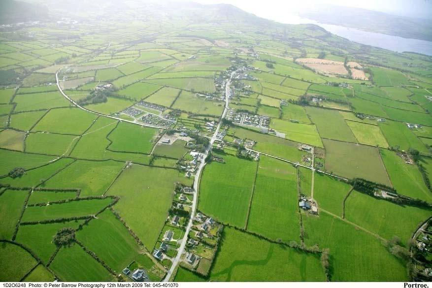
43 1.0 General Introduction and Development Context Location Portroe stands at 182 metres/605 feet above sea level and has a commanding view of the surrounding countryside, including Lough Derg. It also boasts an attractive church made of cream grit stone. The village is just 2.5-3km from the shores of Lough Derg and is the gateway to the popular harbour of Garrykennedy. The village developed as the Portroe slate quarries prospered. The modern day village has a strong community structure. The village streetscape however, lacks definition and contains a number of under-used sites. Population Portroe extends over a much larger area than the defined village itself. During the period between 2002 and 2006 the population of the Castletown DED (within which Portore is located) grew by 10.5% from 1223 people to 1352 people. Settlement Form The settlement has developed in a linear pattern running along the regional road and in a northeast, south-west axis from the crossroads. The original settlement is likely to have developed as a small cluster to the western end of the village. Subsequent expansion has in the main, taken the form of linear development along the constituent roads. This settlement is low rise and low density, with a number of different building styles in evidence, although the original core has a slightly tighter grain and more vernacular style. Tourism Having regard to its proximity to the lake and particularly Garrykennedy, Portroe attracts tourists to the Lough Derg area. The village offers the potential to further develop as a tourist destination and economic driver within the region. 2.0 Key Aim and Objectives The key aim of the settlement plan is to provide a framework for the development of residential, commercial and other appropriate development and to enhance the visual character and amenities of the village. Key Objectives To facilitate low density, high quality housing appropriate to the village location to ensure adequate critical mass to maintain/improve local service provision. To provide, maintain and enhance social, community and amenity facilities within the village. Reinforce the attractive rural village which exists at present by permitting appropriate and sensitively designed new development. To support opportunities for commercial and employment facilities. Cater for a number of small in-depth housing schemes, serviced sites developments and also commercial / employment generating development which is appropriate in terms of scale, use and location within the village. 86

44 Consolidate development within the delineated village boundary in order to protect the area of high amenity within which the village is set. Foster the creation of a more coherent settlement, with adequate critical mass to maintain/improve local service provision. 3.0 Services and Social Infrastructure Water Supply The village is serviced by a public water supply. Waste Water The settlement is serviced by a waste water treatment plant and public sewer. The existing sewage treatment plant has limited capacity and as such upgrade works may be required during the lifetime of the Plan. Notwithstanding that the amount of land zoned in the plan allows for growth in the town, normal planning development management practice is that proposals are assessed as regards capacity of services to cater for them and development would not be permitted unless adequate treatment can be assured. Any development proposed within the village will need to clearly demonstrate this as part of any planning application. Roads and Transport Infrastructure. Portroe is located on the Regional Road R494 with the local road L-2138 leading to Garrykennedy and the L-2135 leading to the Portroe Slate quarries and the Arra Mountains. There is a limited network of public footpaths and public lighting within the village. Social and Community Infrastructure The village is served by a primary school, Roman Catholic Church, garda station, a public house, community hall, garage/petrol station, and some shops. The local sports club have a playing field and club house within the village boundary. 4.0 Architectural and Archaeological Heritage There are a number of historic buildings and sites within the village boundaries. Significant buildings within the village considered worthy of note in and around the village are illustrated below. St Marys R.C. Church S 620 Former RIC Barracks S
45 5.0 Key Messages for Portroe The settlement should be developed in a properly planned and co-ordinated manner in accordance with the zoning objectives of the settlement plan. Low density rural clustered style development is promoted on residential zoned sites. Promotion of low-density linear or clustered style development within the village, with the exception of slightly tighter knit development in the core. Facilitate and encourage the development of commercial and employment opportunities which are necessary in sustaining its tourism base. Encourage the use of natural building and boundary materials. The conservation and integration into new development of existing stone walls, trees and native hedgerows, and promotion of similar materials for new boundaries. High quality designs, which are reflective of the existing rural character of the village, without precluding high quality innovative contemporary designs. Improved public footpaths and lighting should be provided as part of all new developments. 6.0 General Development Objectives Proposals for development will be assessed in accordance with the policies and objectives of the, as set out in the main text in Volume 1. In addition to general policy requirements for development, the Council will seek to implement the following objectives: The Council will seek to improve and extend the provision of footpaths and public lighting to enhance the local infrastructure. The Council will seek to foster a village identity and definition of the village by facilitating the provision of hard and soft landscaping and signage. A traditional streetscape which maintains where possible the front boundary wall and trees. The Council will seek to ensure hedgerows, trees and any natural stone walls are preserved and maintained in any new development proposals. Promotion of low-density linear or clustered style development within the village, with the exception of slightly tighter knit development in the core. Buildings which respect the scale, massing and design of existing buildings in the village. The Council will seek to ensure the protection of protected structures, historic buildings and buildings/structures of archaeological significance. The Council will seek to control ribbon development on the approach roads to preserve and consolidate the built environment of the village. Enhancement of gateway features and natural edges as the opportunities arise, so as to increase the sense of place and character of the village. Access points to be provided where necessary, within the proposed development boundary. The incremental provision of footpaths through development contributions / special development contributions or requirements for works as part of planning permissions granted is envisaged, to improve the amenities of the area. Pedestrian linkages should be provided as part of any new development to link to public thoroughfares or existing developments. The provision of serviced sites on residentially zoned lands on the Garrykennedy road should be accessed with a single access point only. 88
46 STAGE ONE FLOOD RISK ASSESSMENT - PORTROE 1.0 Introduction This is the Stage 1 Flood Risk Identification for Variation No. 1 of the 2010 (hereafter referred to as the Plan), prepared in accordance with the Planning System and Flood Risk Management Guidelines for Planning Authorities published by the Department of the Environment, Heritage and Local Government and the OPW in November The purpose of this process is to identify whether there may be any flooding or surface water management issues related to the plan area that may warrant further investigation through stage 2 and 3 Flood Risk Assessment. This stage 1 Flood Risk Assessment forms an integral part of the SEA process for Variation of the Plan and will inform the approach to future planning and development in North Tipperary. 2.0 Flood Risk Identification (Stage 1) The following sources of information have been investigated in order to determine flood risk potential; 1. OPW preliminary Flood Risk Assessment indicative fluvial flood maps. 2. Predictive and historic flood maps, and benefiting land maps, such as those at 3. Predicative flood maps produced under the CFRAM. 4. River Basin Management Plans and reports. 5. Indicative assessment of existing flood risk under preliminary flood risk assessment. 6. Expert advice from OPW 7. Consultation with local authority 8. Topographical maps. 9. GSI Alluvial deposit map. 10. Liable to flood markings on the old 6 inch maps. 11. Newspaper reports. 12. Consultation with Local Community 13. Walkover survey Each of these sources is addressed individually below: 1. OPW preliminary Flood Risk Assessment indicative fluvial flood maps. These are being produced through the catchment-based Flood Risk Assessment and Management Study. These maps are not yet available for the River Shannon Catchment. 2. Predictive and historic flood maps, and benefiting land maps, such as those at This website was consulted. It was found that there were no recorded flood events in the village of Portroe. 3. Predicative flood maps produced under the CFRAM. The Shannon Catchment Flood Risk and Management Study (CFRAM) is to be commenced in 2010 and is scheduled to be completed by the end of Therefore the predicative flood maps to be prepared under this project are not yet available. 89
 is to be commenced in 2010 and is scheduled to be completed by the end of 2013.")
47 4. Catchment Flood Risk Assessment and Management Plans and reports. The Shannon Catchment Flood Risk and Management Study (CFRAM) is to be commenced in 2010 and is scheduled to be completed by the end of Therefore this Stage 1 Flood Risk Assessment has not been able to make reference to any guidance or information which may be contained within it. It is hoped that as part of the review of the Plan, to be completed by 2013 that this information will be available and can feed into the Assessment for the new Plan. 5. Indicative assessment of existing flood risk There is no river flowing through Portroe village and the topography is such that the land falls from a west to east direction. No flood event has been recorded in Portroe in recent years. The village is situation on high ground ( meters above sea level). It is noted that the OPW has no recorded flood events in the village either. 6. Expert advice from OPW This Stage 1 Flood Risk has been undertaken with the advantage of expert advice from the OPW. 7. Consultation with local authority A site visit was undertaken and planning histories consulted. There is no evidence of flooding history. 8. Topographical maps. County Topographical maps do not adequately address the local Portroe area as they are based on the topography of the county. 9. GSI Alluvial deposit map. GSI Soils Map for Portroe 90
48 The GSI Soils map is set out above for Portroe. The red area represents that area where Acid Brown Earths Brown Podzolics soils are in existence. The type group it belongs to is deep well drained minerals. The cyan area represents that area where manmade soils are in existence. The GSI Soils Map has informed the Land Use Zoning Map. 10. Liable to flood markings on the old 6 inch maps. None of the lands within the village or within the settlement boundary have been identified on the 6 maps as being liable to flooding. 11. Newspaper reports The Newspaper Reports available at were consulted as part of this Stage 1 Flood Risk Assessment. There was no record of reports of flooding in the village. 12. Consultation with local people. Consideration will be given to any comments received during the public consultation phase on the 2010 Development Plan variation that relate to flooding in the area. 13. Walkover survey to assess potential sources of flooding. A number of inspections were carried out on site by the Planning Officer during the preparation of the Variation. 3.0 Conclusion This is the Stage 1 Flood risk assessment for Variation No. 1 to the The Planning Authority is satisfied that there is no potential flood risk identified in areas planned for growth in Portroe based on an assessment of all the sources listed above and bearing in mind a precautionary approach. This report should be read in conjunction with the SEA and HDA documentation prepared as part of the variation process. It is concluded that there will be no significant flood risk to the Plan area and any surrounding areas as a result of Variation No. 1 to the
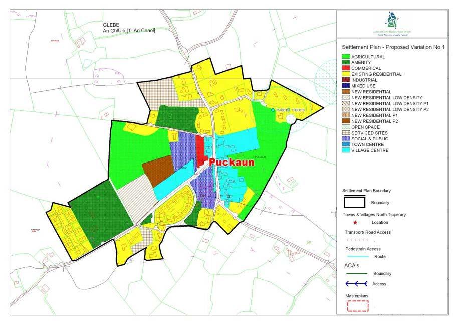
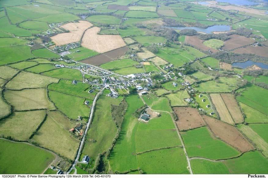
49 PUCKAUN SETTLEMENT PLAN 92
50 1.0 General Introduction and Development Context Location A little inland from Lough Derg is Puckaun (Pocán), an attractive and busy village. Its traditional style cottages are interesting and attractive. Puckaun nestles between the unspoilt shores of Lough Derg and the bustling shopping town of Nenagh It is 10km north of Nenagh Population Puckaun extends over a much larger area than the defined village itself and is contained within the Knigh DED. During the period 1991 and 2006 the population of the Knigh DED grew by 13.4%. In fact there has been a higher increase in population in Knigh between the 1996/2002 Census (14.3%) and the 2002/2006 Census (3.7%). The 2006 census reports a population of 239 for the village of Puckaun which is a decrease of 11.2% from the previous census. Settlement Form The settlement has developed in a linear pattern running along the regional road R493 and in a north south axis. The original settlement is likely to have developed as a small cluster and subsequent expansion has in the main, taken the form of linear development along the constituent roads. This settlement is low rise and low density, with a number of different building styles in evidence, although the original core has a slightly tighter grain and more vernacular style. Tourism Having regard to its proximity to the lake and its picturesque setting, Puckaun attracts tourists to the Lough Derg area. The village was the first to be chosen in North Tipperary for the development of twelve Rent an Irish Cottage units in the early 1970s and as such the village offers the potential to further develop as a tourist destination and economic driver within the region. 2.0 Key Aim and Objectives The key aim of the settlement plan is to provide a framework for the development of residential, commercial and other appropriate development and to enhance the visual character and amenities of the village. Key Objectives To facilitate low density, high quality housing appropriate to the village location to ensure adequate critical mass to maintain/improve local service provision. To provide, maintain and enhance social, community and amenity facilities within the village. Reinforce the attractive rural village which exists at present by permitting appropriate and sensitively designed new development. To support opportunities for commercial and employment facilities. Cater for a number of small in-depth housing schemes, serviced sites developments and also commercial / employment generating development which is appropriate in terms of scale, use and location within the village. 93


51 Consolidate development within the delineated village boundary in order to protect the area of high amenity within which the village is set. Foster the creation of a more coherent settlement, with adequate critical mass to maintain/improve local service provision. 3.0 Services and Social Infrastructure Water Supply The village is serviced by a public water supply. Waste Water The settlement is serviced by a waste water treatment plant and public sewer. The existing sewage treatment plant has limited capacity and as such upgrade works may be required during the lifetime of the Plan. Notwithstanding that the amount of land zoned in the plan allows for growth in the village, normal planning development management practice is that proposals are assessed as regards capacity of services to cater for them and development would not be permitted unless adequate treatment can be assured. Any development proposed within the village will need to clearly demonstrate this as part of any planning application. Roads and Transport Infrastructure. Puckaun is located on the Regional Road R493. There is a limited network of public footpaths and public lighting within the village. Social and Community Infrastructure The village is served by a primary school, Roman Catholic Church, two public houses, a local shop, and a number of sporting facilities including a GAA pitch and club house, and a tennis club and club house. 4.0 Architectural and Archaeological Heritage There are a number of historic buildings and sites within the village boundaries. Significant buildings within the village considered worthy of note in and around the village are illustrated below. R.C. Church S 573 Pats Cottage 94
52 5.0 Key Messages for Puckaun The settlement should be developed in a properly planned and co-ordinated manner in accordance with the zoning objectives of the settlement plan. Low density rural clustered style development is promoted on residential zoned sites. Promotion of low-density linear or clustered style development within the village, with the exception of slightly tighter knit development in the core. Promote the retention of traditional buildings within the village core forming a streetscape. Facilitate and encourage the development of commercial and employment opportunities which are necessary in sustaining its tourism base. Encourage the use of natural building and boundary materials. The conservation and integration into new development of existing stone walls, trees and native hedgerows, and promotion of similar materials for new boundaries. High quality designs, which are reflective of the existing rural character of the village, without precluding high quality innovative contemporary designs. Improved public footpaths and lighting should be provided as part of all new developments. 6.0 General Development Objectives Proposals for development will be assessed in accordance with the policies and objectives of the, as set out in the main text in Volume 1. In addition to general policy requirements for development, the Council will seek to implement the following objectives: The Council will seek to foster a village identity and definition of the village by facilitating the provision of hard and soft landscaping and signage. A traditional streetscape which maintains where possible the front boundary wall and trees. The Council will seek to ensure hedgerows, trees and any natural stone walls are preserved and maintained in any new development proposals. Promotion of low-density linear or clustered style development within the village, with the exception of slightly tighter knit development in the core. Buildings which respect the scale, massing and design of existing buildings in the village. Pedestrian linkages should be provided as part of any new development to link to public thoroughfares or existing developments. The Council will seek to ensure the protection of protected structures, historic buildings and buildings/structures of archaeological significance. The Council will seek to control ribbon development on the approach roads to preserve and consolidate the built environment of the village. Enhancement of gateway features and natural edges as the opportunities arise, so as to increase the sense of place and character of the village. Access points to be provided where necessary, within the proposed development boundary. The incremental provision of footpaths through development contributions / special development contributions or requirements for works as part of planning permissions granted is envisaged, to improve the amenities of the area. The provision of serviced sites on residentially zoned lands. All developments within the village shall have due regard to the Puckaun Village Design Statement. 95
53 STAGE ONE FLOOD RISK ASSESSMENT - PUCKAUN 1.0 Introduction This is the Stage 1 Flood Risk Identification for Variation No. 1 of the 2010 (hereafter referred to as the Plan), prepared in accordance with the Planning System and Flood Risk Management Guidelines for Planning Authorities published by the Department of the Environment, Heritage and Local Government and the OPW in November The purpose of this process is to identify whether there may be any flooding or surface water management issues related to the plan area that may warrant further investigation through stage 2 and 3 Flood Risk Assessment. This stage 1 Flood Risk Assessment forms an integral part of the SEA process for Variation of the Plan and will inform the approach to future planning and development in North Tipperary. 2.0 Flood Risk Identification (Stage 1) The following sources of information have been investigated in order to determine flood risk potential; 1. OPW preliminary Flood Risk Assessment indicative fluvial flood maps. 2. Predictive and historic flood maps, and benefiting land maps, such as those at 3. Predicative flood maps produced under the CFRAM. 4. River Basin Management Plans and reports. 5. Indicative assessment of existing flood risk under preliminary flood risk assessment. 6. Expert advice from OPW 7. Consultation with local authority 8. Topographical maps. 9. GSI Alluvial deposit map. 10. Liable to flood markings on the old 6 inch maps. 11. Newspaper reports. 12. Consultation with Local Community 13. Walkover survey Each of these sources is addressed individually below: 1. OPW preliminary Flood Risk Assessment indicative fluvial flood maps. These are being produced through the catchment-based Flood Risk Assessment and Management Study. These maps are not yet available for the River Shannon Catchment. 2. Predictive and historic flood maps, and benefiting land maps, such as those at This website was consulted. It was found that there were no recorded flood events in the village of Puckaun. 3. Predicative flood maps produced under the CFRAM. The Shannon Catchment Flood Risk and Management Study (CFRAM) is to be commenced in 2010 and is scheduled to be completed by the end of Therefore the predicative flood maps to be prepared under this project are not yet available. 96
 is to be commenced in 2010 and is scheduled to be completed by the end of 2013.")
54 4. Catchment Flood Risk Assessment and Management Plans and reports. The Shannon Catchment Flood Risk and Management Study (CFRAM) is to be commenced in 2010 and is scheduled to be completed by the end of Therefore this Stage 1 Flood Risk Assessment has not been able to make reference to any guidance or information which may be contained within it. It is hoped that as part of the review of the Plan, to be completed by 2013 that this information will be available and can feed into the Assessment for the new Plan. 5. Indicative assessment of existing flood risk There is no river flowing through Puckaun village and the topography is such that the land falls gently from a south to north direction. No flood event has been recorded in Puckaun in recent years. It is noted that the OPW has no recorded flood events in the village either. 6. Expert advice from OPW This Stage 1 Flood Risk has been undertaken with the advantage of expert advice from the OPW. 7. Consultation with local authority A site visit was undertaken and planning histories consulted. There is no evidence of flooding history. 8. Topographical maps. County Topographical maps do not adequately address the local Puckaun area as they are based on the topography of the county. 9. GSI Alluvial deposit map. GSI Soils Map for Puckaun 97
55 The GSI Soils map is set out above for Puckaun. The predominant soil within the village boundary, the cyan area, is manmade soil. The area in purple represents the area where grey brown podzolics brown earths are in existence. The type group it belongs to is deep well drained minerals. The area in grey represents the area where rendzinas lithosols soils are in existence. The soil type it belongs to is shallow well drained minerals. The GSI Soils Map has informed the Land Use Zoning Map. 10. Liable to flood markings on the old 6 inch maps. None of the lands within the village or within the settlement boundary have been identified on the 6 maps as being liable to flooding. 11. Newspaper reports The Newspaper Reports available at were consulted as part of this Stage 1 Flood Risk Assessment. There was no record of reports of flooding in the village. 12. Consultation with local people. Consideration will be given to any comments received during the public consultation phase on the 2010 Development Plan variation that relate to flooding in the area. 13. Walkover survey to assess potential sources of flooding. A number of inspections were carried out on site by the Planning Officer during the preparation of the Variation. 3.0 Conclusion This is the Stage 1 Flood risk assessment for Variation No. 1 to the The Planning Authority is satisfied that there is no potential flood risk identified in areas planned for growth in Puckaun based on an assessment of all the sources listed above and bearing in mind a precautionary approach. This report should be read in conjunction with the SEA and HDA documentation prepared as part of the variation process. It is concluded that there will be no significant flood risk to the Plan area and any surrounding areas as a result of Variation No. 1 to the
56 SILVERMINES SETTLEMENT PLAN

57 1.0 General Introduction and Development Context Location Silvermines village is located approximately 9km south west of Nenagh and at the junction of two regional roads, the R-499 and R-500. Population The village is located within the DED of Kilmore which has a population of 579 persons. The population increased by 5.1% from 551 to 579 persons between 1996 and By the 2006 Census the population had increased to 642, an increase of 10%. Settlement Form Silvermines has a picturesque setting located at the foot of the Step Forest and the Silvermines mountains. The settlement has is characterised by this unique natural environment, a strong and well consolidated vernacular streetscape and historic buildings linked to the village s mining heritage. New residential development has generally contributed to the character of the settlement. 2.0 Key aim and objectives Silvermines is a designated local service centre under the settlement hierarchy as set out in Chapter 3 of the Development Plan. Therefore the settlement has a key role in terms of service provision both for the village and its surrounding rural hinterland. The key aim of the settlement plan is provide a land use framework to promote the expansion of residential, employment, social and community service provision. Key Objectives To protect the village core and designated Architectural Conservation Area through the promotion of the maintenance of buildings and encouraging appropriate re-use of structures. To protect and support the tourism potential of the village. To facilitate low density, high quality housing appropriate to the village location. To promote the development of tourism facilities and mining heritage attractions.
58 To maintain and enhance social, community and amenity facilities within the village. To support opportunities for commercial and employment facilities. 3.0 Services and Social Infrastructure Water Supply The village is serviced by a public water supply. Waste Water The village is served by a wastewater treatment plant. Road and Transport Infrastructure Silvermines village is well connected to transport links given its proximity to the N7 and its location an a regional road corridor linking the N7 to Dolla and onto Toomevara. There is a limited network of public footpaths in the area. Public lighting is provided throughout the settlement. Social and Community Infrastructure The village is quite a well-serviced village, with a shop, two pubs, community hall and school. There have also been a number of community developed amenity areas, such as the picnic area near the school and a landscaped area on the southern approach road. The Miner s Sculpture is a striking feature in the heart of he village which provides a incidental public space and contributed to the character of the streetscape. 4.0 Architectural Heritage Architectural Conservation Area The main street has been designated an ACA under the Plan and is illustrated on the attached map. There are a number of structures which are protected under the plan, under the Draft Plan, including those which relate to the mining heritage of the area.

59 RC Chruch and objectives of the County Development Plan, as set out in the main text in Volume 1. Full record of protected structures is contained in Volume III of the Plan. 5.0 Key Messages for Silvermines The settlement should be developed in a properly planned and coordinated manner in accordance with the zoning objectives of the settlement plan. The re-use of existing structures within the village centres is encouraged. Low density rural clustered style development is promoted on residential zoned sites. Development within the village should respect the historical and architectural heritage of the village. The local service provision for locals and tourism should be expanded. Tourism development proposals are encouraged. 6.0 General Development Objectives Proposals for development will be assessed in accordance with the policies In addition to general policy requirements for development, the Council will seek to implement the following objectives: The Council will seek to make provision and/or facilitate the provision of footpaths and public lighting to enhance the local infrastructure. The Council will seek to foster a village identity and definition of the village by facilitating the provision of hard and soft landscaping and signage. The Council will seek to ensure the protection of the protected structure and archaeological monument (i.e. by preservation in situ or at a minimum protection by record). The Council will seek to control ribbon development on the approach roads to preserve and consolidate the built environment of the village. The Council will seek to ensure hedgerows, trees and any natural stone walls are preserved and maintained in any new development proposals.
60 TEMPLETOUHY SETTLEMENT PLAN
61 1.0 General Introduction and Development Context Location The village located on the regional road, R502 c. 8km east of Templemore Town. Population The village is located within the District Electoral Division of Templetuohy, which has experienced a population decline during the inter-censal period of 2%, from persons (CSO, 2006). Settlement Form The village has a traditional rural character, with an established main street of vernacular buildings forming a strong core. New housing schemes have been developed on the approach roads, however the village has remained in the main consolidated and defined. 2.0 Key aim and objectives Templetuohy is a designated local service centre under the settlement hierarchy as set out in Chapter 3 of the Draft Development Plan. Therefore the settlement has a key role in terms of service provision both for the village and its surrounding rural hinterland. The key aim of the settlement plan is provide a land use framework to promote the expansion of residential, employment, social and community service provision. Key Objectives To support residential development to achieve a critical mass to facilitate infrastructural improvements in the village. To support the vitality and viability of the town centre through the promotion of the reuse and re-development of existing structures for commercial and residential uses. To facilitate the residential development on zoned sites, which includes low density provision and serviced sites. To maintain and enhance social, community and amenity facilities within the village. To support opportunities for commercial and employment facilities. 3.0 Services and Social Infrastructure Water Supply The village is serviced by an existing public water supply Water Services The village is serviced by a sewage treatment plant. Up-grade works to include tertiary treatment are required.

62 Roads and Transport Infrastructure The village is strategically located on a regional road network linking Templemore and Johnstown. A network of public footpaths and public lighting is provided throughout the settlement. Social and Community Infrastructure Templetuohy provides a range of facilities which contribute to local service provision, including a school, church, community hall, shops, pubs, café and a health centre. 4.0 Architectural Heritage The RC Church located to the south of the main street is a protected structure under the Plan. RC Church S375 The graveyard which takes a prominent position at the east of the village, was the site of a church which dates back to the 5 th century. The graveyard is a recorded monument of archaeological important. 5.0 Key Messages for Templetuohy The settlement should be developed in a properly planned and co-ordinated manner in accordance with the zoning objectives of the settlement plan. Commercial and enterprise developments are promoted to expand the employment based of the settlement. Local service provision should be maintained and enhanced. Low density rural clustered style and serviced sites is promoted on residential zoned site. 6.0 General Development Objectives Proposals for development will be assessed in accordance with the policies and objectives of the County Development Plan, as set out in the main text in Volume 1. In addition to general policy requirements for development, the Council will seek to implement the following objectives: The Council will seek to make provision and/or facilitate the provision of footpaths and public lighting to enhance the local infrastructure. The Council will seek to foster a village identity and definition of the village by facilitating the provision of hard and soft landscaping and signage. The Council will seek to control ribbon development on the approach roads to preserve and consolidate the built environment of the village.
63 The Council will seek to ensure hedgerows, trees and any natural stone walls are preserved and maintained in any new development proposals. The Council will seek the provision of public play areas in new residential developments. The Council will seek to ensure the protection of the protected structures and archaeological monuments (i.e by preservation in situ or at a minimum protection by record).
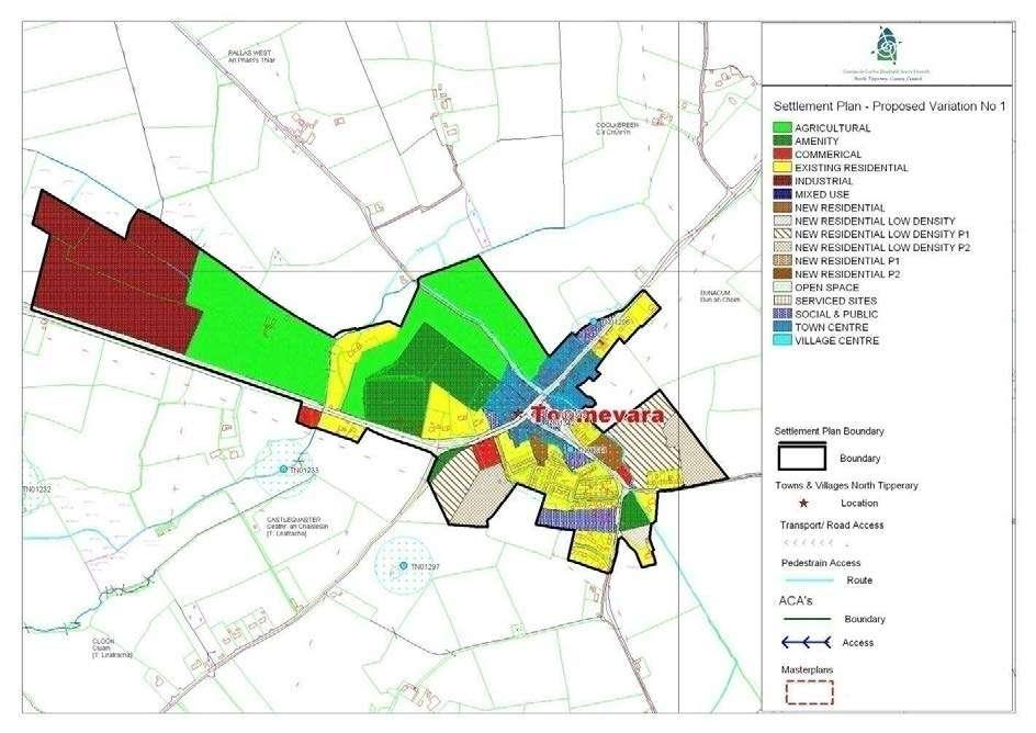
64
65 1.0 General Introduction and Development Context Location Toomevara is located 10km from Nenagh on the N7 national primary road linking Limerick and Dublin. Population The village is located within the Rural Electoral Division of Latteragh, which has experienced a population decline during the inter-censal period of 1.5%, from 639 to 629 persons (CSO, 2006). Settlement Form The village has a traditional settlement pattern, with a strong streetscape of vernacular buildings, which has developed along the national road and local road running to the south west. The settlement is well defined, with a consolidated built environment. 2.0 Key aim and objectives Toomevara is a designated local service centre under the settlement hierarchy as set out in Chapter 3 of the Draft Development Plan. Therefore the settlement has a key role in terms of service provision both for the village and its surrounding rural hinterland. The key aim of the settlement plan is provide a land use framework to promote the expansion of residential, employment, social and community service provision. Key Objectives To support residential and commercial development to achieve a critical mass to support infrastructural improvements in the village. To support the vitality and viability of the town centre through the promotion of the reuse and re-development of existing structures for appropriate commercial and residential uses. To facilitate residential development on zoned sites with provides a mix of dwelling types. To maintain and enhance social, community and amenity facilities within the village. 3.0 Services and Social Infrastructure Water Supply The village is serviced by an existing public water supply Waste Water The village is serviced by a sewage treatment plant. However, up-grade works are required to cater for additional development. Roads and Transport Infrastructure The village is well connected by the N7 to nearby towns of Nenagh and Roscrea.


66 The new M7, which is currently under construction, will bypass the village and will reduce travel times to nearby towns, including the primary service centres of Nenagh and Roscrea. Church of Ireland Church S656 The future opening of the motorway will have a number of advantages for the settlement, including increased traffic and pedestrian safety, reduced noise and pollution. There is an extensive network of public footpaths in the area and public lighting is provided throughout the settlement. 4.0 Architectural and Archaeological Heritage The village has a number of features of architectural and archaeological importance in the village RC Church which is a protected structure and Josie s Molony s pub and the protestant church which is proposed for protection under the draft Plan. RC Church S385 Archaeoglcial monuments within the village include the ruined church and graveyard in the central amenity space. Full record of protected structures is contained in Volume III of the Plan. 5.0 Key Messages for Toomevara The settlement should be developed in a properly planned and co-ordinated manner in accordance with the zoning objectives of the settlement plan. The expansion of commercial and To expansion of enterprise and employment generating commercial activity is promoted. To expansion of local service provision and community facilities is promoted. The re-use and redevelopment of existing buildings in town centre is encouraged.
67 Low density housing and serviced sites are promoted on residentially zoned land. in situ or at a minimum protection by record). 6.0 General Development Objectives Proposals for development will be assessed in accordance with the policies and objectives of the County Development Plan, as set out in the main text in Volume 1. In addition to general policy requirements for development, the Council will seek to implement the following objectives: The Council will seek to make provision and/or facilitate the provision of footpaths and public lighting to enhance the local infrastructure. The Council will seek to foster a village identity and definition of the village by facilitating the provision of hard and soft landscaping and signage. The Council will seek to ensure the protection of the protected structures and designated conservations areas within the village. The Council will seek to control ribbon development on the approach roads to preserve and consolidate the built environment of the village. The Council will seek to ensure hedgerows, trees and any natural stone walls are preserved and maintained in any new development proposals. The Council will seek to ensure the protection of the protected structure and archaeological monuments (i.e by preservation
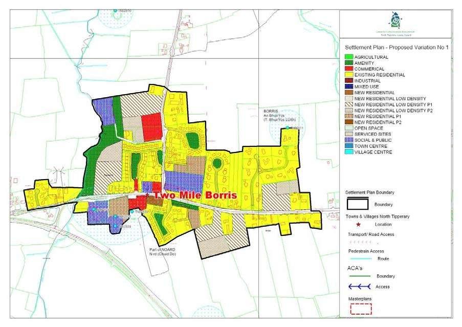
68
69 1.0 General Introduction and Development Context the N75 where there has been extensive ribbon development both to the east and west of the settlement Location Two-Mile-Borris is located on the N-75 national secondary road c. 6km east of Thurles. Population The population of Two Mile Borris given its proximity to Thurles, has increased significantly over the past 15 years. The population in 1991 was 298 person, while the population in 2006 was 831 (CSO, 2006). Settlement Form The village has expanded from a small cluster of building at the cross roads in a linear pattern along the N75. New residential development has been significant, relative to the scale of the village with the development of a number of housing off the main road and local road running to the north. Notably these new developments have singular access point off the main roads which has not aided the integration and consolidation of the built environment. The village lack definition with its agricultural hinterland, particularly along 2.0 Key aim and objectives Two-Mile Borris is a designated local service centre under the settlement hierarchy as set out in Chapter 3 of the Development Plan. Therefore, the settlement has a key role in terms of service provision both for the village and its surrounding rural hinterland. The key aim of the settlement plan is provide a land use framework to promote the expansion of residential, employment, social and community service provision. Key Objectives To support the vitality and viability of the village through the promotion of the commercial development and local service provision to serve the settlement and its hinterland. To facilitate residential development on zoned sites, to consolidate development within the settlement boundary. To maintain and enhance social, community and amenity facilities within the village. To support opportunities for commercial and employment provision. 3.0 Services and Social Infrastructure Water Supply The village is serviced by a public water supply.

70 Waste Water There village is serviced by a public wastewater treatment plant. Up-grade works to include tertiary treatment is required. St. James RC Church S840 Roads and Transport Infrastructure The village is strategically located north of the recently opened M8 and its associated interchange, which provides an access point to Thurles. The recently opened motorway has served to significantly reduce traffic volume through the village, thereby increasing pedestrian and road safety, reducing noise levels and improving air quality. There is an extensive network of public footpaths in the area and public lighting is provided throughout the settlement. Social and Community Infrastructure The village provides a range of services including shops, public houses, post office, commercial garage, school and St. James s Church. 4.0 Architectural and Archaeological Heritage The RC Church, which occupies a prominent position in the heart of the settlement, is a protected structure under the Plan. There are a number of recorded archaeological monuments at the southwestern edge of the village including a tower house, deserted settlement, and associated church and graveyard. 5.0 Key Messages for Two-Mile-Borris The settlement should be developed in a properly planned and co-ordinated manner in accordance with the zoning objectives of the settlement plan. Commercial and enterprise development is encouraged within the settlement boundary to expand the service provision and employment base for local residents.
BORRISOKANE SETTLEMENT PLAN
 BORRISOKANE SETTLEMENT PLAN 1.0 General Introduction and Development Context Location Borrisokane is located 15km north of Nenagh on the N52. While the town is primarily residential, it acts as a market
CLOUGHJORDAN SETTLEMENT PLAN
 CLOUGHJORDAN SETTLEMENT PLAN 1.0 General Introduction and Development Context Location The market town of Cloughjordan lies close to the border with Offaly at the junction of the R490 and R491 Regional
Service Centres - North Tipperary County Development Plan 2010 (as varied)
") North Tipperary County Development Plan 2010 (as varied) 2015 Service Centres - North Tipperary County Development Plan 2010 (as varied) Service Centres are outlined below and comprise a written statement
North Tipperary County Development Plan 2010 (as varied) 2015 Service Centres - North Tipperary County Development Plan 2010 (as varied) Service Centres are outlined below and comprise a written statement
Settlement Nodes - North Tipperary County Development Plan 2010 (as varied)
") North Tipperary County Development Plan (as varied) 2010 2015 Settlement Nodes - North Tipperary County Development Plan 2010 (as varied) Settlement Nodes are outlined below and comprise a written statement
North Tipperary County Development Plan (as varied) 2010 2015 Settlement Nodes - North Tipperary County Development Plan 2010 (as varied) Settlement Nodes are outlined below and comprise a written statement
28. Coolaney-Rockfield Mini-Plan
 28. Coolaney-Rockfield Mini-Plan 28. Coolaney-Rockfield Mini-Plan Community facilities Community facilities in Coolaney-Rockfield consist of a primary school, crèche, community centre, sports field and
County Development Plan Consolidated Draft + Adopted Amendments August 2017 Volume 2, Chapter 22 Easky Mini-Plan
 22. Easky Mini-Plan Village profile Easky is a coastal settlement located approximately 40 km to the west of Sligo City, in a designated Rural Area In Need of Regeneration. The nearby coastline is designated
20. Ballysadare Mini-Plan
 20. Ballysadare Mini-Plan 20. Ballysadare Mini-Plan Community facilities Ballysadare has a wide range of community facilities: a primary school, St Mary s College (secondary school), a health centre, playing
30. Riverstown Mini-Plan
 County Development Plan 2017-2023 Consolidated Draft + Adopted Amendments August 2017 Volume 2, Chapter 30 Riverstown Mini-Plan 30. Riverstown Mini-Plan Village profile Riverstown is located approximately
17. Coolaney-Rockfield Mini-Plan
 County Development Plan 2017-2023 Consolidated Draft + Adopted Amendments - August 2017 17. Coolaney-Rockfield Mini-Plan Village profile Coolaney is located approximately 23 km to the south-west of Sligo
Rathmolyon Written Statement
 Settlement Rathmolyon Position in Settlement Hierarchy Village - Local centre for services and local enterprise development Position in Retail Strategy Fourth tier retail centre Population (2011) Census
5. Bankside and The Borough 5.1. Bankside and The Borough Area Vision
 5. 5.1. Area Vision 5.1.1. are: A globally significant central London business district which is home to international business headquarters; At the heart of the commercial and cultural life of the capital
13. London Bridge London Bridge Area Vision
 13. 13.1. Area Vision 13.1.1. is: A globally significant central London business district which is home to international business headquarters; Internationally renowned for its prominent riverfront location
Public Consultation. Land at Monks Farm, North Grove. Welcome
 Welcome Welcome to our public exhibition for development on Land at Monks Farm, orth Grove. Gallagher Estates and Gleeson Strategic Land are preparing an outline planning application for new homes, open
Welcome to our public exhibition
 About Our Scheme Welcome to our public exhibition This exhibition gives you the chance to view and comment upon our emerging proposals for a new residential development of 68 new homes on the site of the
6. Ballintogher Mini-Plan
 County Development Plan 2017-2023 Consolidated Draft + Adopted Amendments August 2017 Volume 2, Chapter 6 Ballintogher Mini-Plan 6. Ballintogher Mini-Plan Village profile Ballintogher is located approximately
Page 1 of 19 URBAN DESIGN FRAMEWORK FOR BOLTON STREET WATERFORD
 Page 1 of 19 URBAN DESIGN FRAMEWORK FOR BOLTON STREET WATERFORD 1.0 Introduction: The relocation of the City Council stores and depot from Bolton Street creates an exciting opportunity for development
Overview Report. Proposed Development
 Overview Report Proposed Development the construction of a 1km cycle/pedestrian trail including a new footbridge, new car park and entrance road at Drumshanbo Lock and a new pedestrian/cycle road crossing,
3.0 Area-Wide Strategies 30
 3.0 Area-Wide Strategies 30 3.6 Tourism Strategy This section of the plan aims to develop and improve the tourism potential of the area. Strategic Context The City Plan outlines the potential of Cork to
Kibworth Harcourt. Introduction. Introduction
 Introduction Introduction Welcome to this public exhibition on the proposals for the delivery of new homes on land at The Kibworths. The purpose of today s exhibition is to give you the opportunity to
2.0 Strategic Context 4
 2.0 Strategic Context 4 2.1 The Area Action Plan is a non-statutory plan, which forms a corporate policy document, expressing particular issues and areas of concern while also providing a vision for the
8.0 Design and Form of Development 43/
 42/ 8.0 Design and Form of Development 43/ Rothwells Farm, Golborne/ Development Statement Figure 7. Site Constraints Key 44/ Site Boundary 360 Bus Route/Stops Existing Trees Underground Water Pipe Sensitive
Welcome to our public exhibition
 About our development Welcome to our public exhibition This exhibition gives you the chance to view and comment on our proposals for a new residential development of 165 high-quality homes, along with
Ballivor Written Statement
 Settlement Ballivor Position in Settlement Hierarchy Village - Local centre for services and local enterprise development Position in Retail Strategy Fourth tier retail centre Population (2011) Census
Colchester Northern Gateway Master Plan Vision Review Draft. July 2016
 Colchester Northern Gateway Master Plan Vision Review Draft July 2016 Contents Introduction 4 Context 8 Purpose of the Report 8 Strategic Position 9 Overview of the Process 11 2012 Master Plan Vision 12
Newcourt Masterplan. November Exeter Local Development Framework
 Newcourt Masterplan November 2010 Exeter Local Development Framework Background The Exeter Core Strategy Proposed Submission sets out the vision, objectives and strategy for the development of Exeter up
3.3. Urban Structure Defining a New Hierarchy of Routes and Spaces >Images
 Section 3.0 I The Masterplan Framework 18 >Images Examples of high quality routes and spaces 3.3. Urban Structure The success of any masterplan lies in a clear definition of the future urban structure
Planning and Sustainability Statement
 Land adjacent to Manor Farm, Catterick Village Pallett Hill Sand and Gravel Co Ltd Proposed 10 new dwellings, (6 No market dwellings and 4 No affordable dwellings) with access, associated car parking and
Drrumconrratth Wrriitttten Sttattementt. Position in Settlement Hierarchy Village - Local centre for services and local enterprise development
 Drrumconrratth Wrriitttten Sttattementt Settlement Drumconrath Position in Settlement Hierarchy Village - Local centre for services and local enterprise development Position in Retail Strategy Level 4
elbridge Core Strategy
 C elbridge Core Strategy Celbridge is designated as a Moderate Growth Town in the RPGs. The County Development Plan reinforces this designation in its settlement strategy. Moderate Growth Towns within
WELCOME. Land North of STEVENAGE. We would like to thank you for attending our public exhibition today.
 WELCOME We would like to thank you for attending our public exhibition today. The purpose of this event is to share our proposals and hear your thoughts on our ideas. Members of the project team are on
WELCOME TO THE NEW WILTON PARK
 WELCOME TO THE NEW WILTON PARK VISION HISTORY OF WILTON PARK TOWARDS A PLANNING APPLICATION Our objective is to create a truly outstanding environment at Wilton Park. At the heart of our proposals is a
7.2.9 Eudlo local plan code
 7.2.9 local plan code 7.2.9.1 Application (1) This code applies to assessable development:- (a) within the local plan area as shown on Map ZM29 contained within Schedule 2 (Mapping); and (b) identified
35. Gorteen Mini-Plan
 35. Gorteen Mini-Plan 35. Gorteen Mini-Plan Community facilities Community facilities in Gorteen consist of a crèche, community centre, sports field, church, burial ground and health centre. The former
Welcome to our exhibition
 Welcome to our exhibition The Homes & Communities Agency (HCA) welcomes you to this public exhibition explaining our proposals for the redevelopment of the former Lea Castle Hospital site. About the Homes
Clonard Written Statement
 Settlement Clonard Position in Settlement Hierarchy Village - Local centre for services and local enterprise development Position in Retail Strategy Fourth tier retail centre Population (2011) Census 339
WELCOME GYPSY LANE. Wider Site Location plan. Proposals for the development of LAND OFF FOXLYDIATE LANE WEBHEATH. Proposals for the development of
 WELCOME The developers are preparing an outline planning application for a residential led development and need the community s views in order to develop the proposals further WHAT IS PROPOSED? A high
6 PORT SYDNEY SETTLEMENT AREA
 Section 6 Port Sydney Page 61 6 PORT SYDNEY SETTLEMENT AREA 6.1 Basis and Principles Village of Port Sydney Waterfront Community Existing Services 6.1.1 Port Sydney is an historic settlement that has developed
6 Site Framework Strategies
 6 Site Framework Strategies 6.1 Introduction Section 6 identifies a number of specific areas which are considered to be key sites within the Plan area and which may have potential for development / redevelopment.
16. Collooney Mini-Plan
 16. Collooney Mini-Plan Village profile Collooney is located approximately 13 km to the south of Sligo City, in a designated Rural Area under Urban Influence. The village provides a range of services for
8. Camberwell 8.1. Camberwell Area Vision
 8. 8.1. Area Vision 8.1.1. is: Centred on a medieval village centre which has become a thriving modern town centre surrounded by residential streets laid out in the Georgian era; Linked by rail to central
Site ref: AS06 Site Name or Address: Murreys Court, Agates Lane
 Site ref: AS06 Site Name or Address: Murreys Court, Agates Lane Proposed Land Use: Total Site Area (Ha): Housing 1.85 Ha Description: It is understood that the owner has no plans to dispose of the site
STATEMENT OF OBJECTION TO THE PROPOSED DEVELOPMENT OF LAND AT CHURCH CLIFF DRIVE FILEY
 STATEMENT OF OBJECTION TO THE PROPOSED DEVELOPMENT OF LAND AT CHURCH CLIFF DRIVE FILEY You will be aware that Scarborough borough council have adopted a new local plan that includes land at Church Cliff
INTRODUCTION. Land West of Main Road, Stanton Harcourt THE SITE. Why is the Site Suitable for Development?
 0 INTRODUCTION THE SITE Application Boundary Gladman Developments Ltd has successfully invested in communities throughout the UK over the past 0 years, developing high quality and sustainable residential,
6. Bermondsey 6.1. Bermondsey Area Vision
 6. 6.1. Area Vision 6.1.1. is: An inner-london neighbourhood characterised by modest worker ho associated with the historic Rotherhithe docks and local manufacturing industries such as biscuits, jam, vinegar
Kilmessan Written Statement
 Settlement Kilmessan Position in Settlement Hierarchy Village - Local centre for services and local enterprise development Position in Retail Strategy Fourth tier retail centre Population (2011) Census
Stratford Neighbourhood Plan Questionnaire
 Stratford Neighbourhood Plan Questionnaire Please tick the appropriate box or answer in the space provided. If you require further copies of the questionnaire, as more than one person in the household
RURAL ZONE - POLICY. Rural Zone Policy. Issue: Rural Environment. Ruapehu District Plan Page 1 of 8
 Rural Zone Policy RU2 RURAL ZONE - POLICY RU2.1 Introduction The natural resources of the rural environment in the Ruapehu District provide the basis for the existing and potential character, intensity
7. The Landscape. 7.1 Introduction. Environmental Impact Statement (EIS) Scoping Report
 Scoping Report") 7. The Landscape 7.1 Introduction The purpose of this section of the EIS Scoping Report is to describe the scope of work and methods to be applied in the identification and assessment of landscape and
7. The Landscape 7.1 Introduction The purpose of this section of the EIS Scoping Report is to describe the scope of work and methods to be applied in the identification and assessment of landscape and
Peckham Peckham Area Vision Map
 Area Vision Map PNAAP13 PNAAP8 Sumner Road Surrey Canal Walk Bird in Bush Park Key: NSP Site Allocations PNAAP Allocations Greenspace Low Line Cycle Network Primary Shopping Areas Square Surrey Canal Walk
GREENBANK DEVELOPMENT MASTERPLAN
 DEVELOPMENT MASTERPLAN POTENTIAL TRAIN STATION COMMUNITY CENTRE Greenbank will be a connected masterplanned community providing easy access to local and surrounding amenity. Affordable quality homes, green
London Bridge London Bridge Area Vision Map
 Area Vision Map Borough Market Southwark Cathedral NSP54 Hay s Galleria Key: NSP Site Allocations Greenspace Low Line Thames Path Cycle Network Primary Shopping Areas Borough High Street Tube Station NSP51
Carnaross Written Statement
 Ca n rrnarrossss W t rriittten Sttattementt Settlement Position in Settlement Hierarchy Position in Retail Strategy Population (2011) Geodirectory (No census data available) Committed Housing Units (Not
1.0 INTRODUCTION. Brantham Industrial Area Regeneration - Factory Lane - Brantham
 1.0 INTRODUCTION Welcome to this exhibition of our proposals for the regeneration of the Brantham Industrial Area located off Factory Lane in Brantham. This presentation will give you an opportunity to
Lancaster Conservation Area Appraisal. Character Area 8. Cathedral
 Lancaster Conservation Area Appraisal Character Area 8. Cathedral March 2013 118 3.8 Character Area 8. Cathedral 3.8.1. Definition of Special Interest "This character area is distinctive for the fine group
Camberwell Camberwell Area Vision Map
 Area Vision Map NSP23 Burgess Park Edmund Street NSP29 NSP30 NSP31 New Road Benhill Road NSP27 NSP33 Green Brunswick Park NSP22 station NSP24 Peckham Road NSP26 St Giles Church Lucas Gardens NSP28 NSP25
GREENFORD HALL & ADJOINING LAND
 GREENFORD HALL & ADJOINING LAND CONTENTS 1. Introduction 1. Introduction 2. Urban Context 2.1 The Site and Surroundings 2.2 Urban Context Map 2.3 Access and Movement 3. Planning Context 3.1 Planning History
A. The sites in Table 16 below, as identified on the Policies Map, are allocated for retail-led development:
 SWDP 44: Worcester City Centre A. The sites in Table 16 below, as identified on the Policies Map, are allocated for retail-led development: Table 16: Sites Allocated for Retail-Led Development Policy Reference
Crossakiel Written Statement
 Crrossssakiiell Wrriittten tt Sttattementt Settlement Crossakiel Position in Settlement Hierarchy Village - Local centre for services and local enterprise development Position in Retail Strategy Third
COURTHOUSE CAMPUS BARNSLEY Executive Summary March 2010
 COURTHOUSE CAMPUS BARNSLEY Executive Summary March 2010 Estell Warren Cartwright Pickard Buro Happold King Sturge BWA Barnsley Metropolitan Borough Council introduction Courthouse Campus is the last major
Chapter 2: OUTLINE PLANNING APPLICATION PROPOSALS. A New Garden Neighbourhood Matford Barton 17
 Chapter 2: OUTLINE PLANNING APPLICATION PROPOSALS A New Garden Neighbourhood Matford Barton 17 2.1. SUMMARY AND STATUS OF THE PROPOSALS 2.1.1. The parameter plans and associated wording in this chapter
Schedule of Planning Applications Committee Date: 23 May Reference: 06/17/0726/F Parish: Hemsby Officer: Mr J Beck Expiry Date:
 Schedule of Planning Applications Committee Date: 23 May 2018 Reference: 06/17/0726/F Parish: Hemsby Officer: Mr J Beck Expiry Date: 22-05-2018 Applicant: Proposal: Site: Mr Gillett Change of use to the
CORK County Development Plan 2003
 3 VOLUME 3 Specific Zoning Main Settlements Zoning Main Settlements Contents of Volume 3 Settlement 1: BALLINCOLLIG TEXT MAP Settlement 2: BANDON TEXT MAP Settlement 3: BANTRY TEXT MAP Volume 1: Overall
Introduction. Welcome to this consultation regarding the draft redevelopment proposals for the former CeramTec factory on Sidmouth Road, Colyton.
 Introduction Welcome to this consultation regarding the draft redevelopment proposals for the former CeramTec factory on Sidmouth Road, Colyton. We are currently considering options for the mixed-use redevelopment
SOUTH EAST LINCOLNSHIRE LOCAL PLAN: HOUSING PAPER DONINGTON (JUNE 2016)
") SOUTH EAST LINCOLNSHIRE LOCAL PLAN: HOUSING PAPER DONINGTON (JUNE 2016) 1 DONINGTON S PLACE IN THE SPATIAL STRATEGY 1.1 Policy 2 of the South East Lincolnshire Local Plan 2011-2036 Draft for Public Consultation
SOUTH EAST LINCOLNSHIRE LOCAL PLAN: HOUSING PAPER DONINGTON (JUNE 2016) 1 DONINGTON S PLACE IN THE SPATIAL STRATEGY 1.1 Policy 2 of the South East Lincolnshire Local Plan 2011-2036 Draft for Public Consultation
A Growing Community Rural Settlement Areas
 Town of Huntsville Official Plan Review - POLICY BACKGROUND PAPER A Growing Community Rural Settlement Areas BACKGROUND: In addition to the fully municipally-serviced Urban Settlement Area and the Hidden
About 10% of the Borough's population lives in the seven rural parishes. Population figures from the 1991 census are given below:-
 8. THE DISTRICT VILLAGES 8.1 Population About 10% of the Borough's population lives in the seven rural parishes. Population figures from the 1991 census are given below:- Village No. of Persons Cottingham
INTRODUCTION. Land south of Bishopswood Lane, Tadley
 0 INTRODUCTION THE SITE Introduction Gladman Developments Ltd. has successfully invested in communities throughout the UK over the past 0 years, developing high quality and sustainable residential, commercial
9 Pershore. Introduction. Pershore Abbey
 118 Introduction 9.1 The historic town of Pershore lies on the River Avon and has a population of 7,000 (2009 Mid-Term Population Estimates). The main areas of the town are centred on the Abbey, the bustling
Response to the London Bridge Area Vision and Site Allocations within the New Southwark Plan
 1 Melior Place London SE1 3SZ 020 7407 4701 teamlondonbridge.co.uk info@teamlondonbridge.co.uk 28 April 2017 Response to the London Bridge Area Vision and Site Allocations within the New Southwark Plan
A VISION FOR BLAIRGOWRIE
 Welcome to the Westpark Partnership and Lidl UK GmbH Community Presentation. The purpose of this presentation is for you to view and comment upon the revised and updated proposals for the allocated development
Section 1: Canal. 1.1 Introduction
 Section 1: 1.1 Introduction This Action Area Plan (hereinafter referred to as the Drummonds Mill site or the AAP lands) as indicated on Maps 1 and 2, has been prepared in the context of the Kildare County
Dunboyne/Dunboyne North/ Clonee/ Local Area Plan
 Dunboyne/Dunboyne North/ Clonee/ Local Area Plan Strategic Policy SP 1 To operate an Order of Priority for the release of residential lands in compliance with the requirements of CS OBJ 6 of the County
16. Peckham Peckham Area Vision
 16. 16.1. Area Vision 16.1.1. is: A lively town centre providing a range of daytime and night time activities on Rye Lane including a Library, a Leisure Centre and many independent retailers which specialise
LONGDEN VILLAGE DEVELOPMENT STATEMENT
 LONGDEN VILLAGE DEVELOPMENT STATEMENT 2017-2027 1 Longden Development Statement 2017-2027 15/01/18 1. Background 1.1 Longden Village Longden village is a very rural and traditional community first mentioned
SPG 1. * the northern and western sections which are open fields used for pasture and grazing;
 SPG 1 1.0 INTRODUCTION This development brief is based on the allocation of the Priors Hall site for employment and countryside recreational purposes in the Corby Borough Local Plan. The brief is intended
Droitwich Spa 6. Reasoned Justification
 87 Droitwich Spa 6 Reasoned Justification 6.1 Droitwich Spa is identified in the settlement hierarchy (Policy SWDP1) as a main town being the largest settlement in Wychavon District with an estimated population
Hockessin Community Redevelopment Plan
 Hockessin Community Redevelopment Plan 3.1 Introduction The Community Redevelopment Plan for the Village of Hockessin is the result of the people s vision for a distinct village center that serves as the
10. East Dulwich East Dulwich Area Vision
 10. 10.1. Area Vision 10.1.1. is: A predominantly residential area characterised by mostly medium density housing, including many family homes. Many parts of have retained historic character and it includes
ROSCREA LOCAL AREA PLAN
 ROSCREA LOCAL AREA PLAN 2012-2018 June 2012 Table of Contents Chapter 1:Introduction 1.1 How to use this plan 3 1.2 Purpose of the plan 3 1.3 What is a Local Area Plan 3 1.4 Composition of the Plan 4 1.5
WINCHESTER TOWN 3.1 LOCATION, CHARACTERISTICS & SETTING
 WINCHESTER TOWN 3.1 LOCATION, CHARACTERISTICS & SETTING 3.1.1 The area referred to by the City Council, as Winchester Town, consists of the Winchester Wards plus the adjoining built up areas of Badger
OKEFORD FITZPAINE NEIGHBOURHOOD PLAN
 OKEFORD FITZPAINE NEIGHBOURHOOD PLAN Dear Parishioner, The Neighbourhood Plan Project Team have prepared this leaflet to summarise the full Neighbourhood Plan document. It provides a summary of the Vision,
Welcome. Site/11/04. Site/11/03. Proposed Site. 11,400 new homes needed in east Cambs
 Welcome Welcome to our consultation on our proposals for new homes on land north east of Soham Road, Fordham. Members of the project team are available to answer any questions you have and listen to feedback.
URBAN DESIGN BRIEF. 2136&2148 Trafalgar Road. Town of Oakville
 URBAN DESIGN BRIEF 2136&2148 Trafalgar Road Town of Oakville Prepared By: METROPOLITAN CONSULTING INC For 2500674 Ontario Inc November 2016 TABLE OF CONTENTS Page No. 1.0 Introduction/Description of Subject
BLETCHLEY PARK AREA - DEVELOPMENT FRAMEWORK
 ANNEX A To Item 9 REVISED TEXT: additions shown bold and underlined, deletions in (brackets and in italics). BLETCHLEY PARK AREA - DEVELOPMENT FRAMEWORK This framework sets out the key objectives and requirements
Ratthcaiirrn Wrriitttten Sttattementt
 Ratthcaiirrn Wrriitttten Sttattementt Settlement Rathcairn Position in Settlement Hierarchy Village Serve a smaller rural catchment; provide local services with some smaller scale rural enterprises in
Development of land adjacent to Braggs Farm Lane and Rumbush Lane, Dickens Heath. Welcome. Today s exhibition. The proposal site
 Welcome Welcome to this event to discuss the development of land adjacent to Braggs Farm Lane. is currently in the preliminary stages of designing proposals to sensitively develop this site with high-quality
[PLANNING RATIONALE] For Site Plan Control and Lifting of Holding Zone By-Law 101 Champagne Avenue. May 23, 2014
![[PLANNING RATIONALE] For Site Plan Control and Lifting of Holding Zone By-Law 101 Champagne Avenue. May 23, 2014](/thumbs/75/71599615.jpg "[PLANNING RATIONALE] For Site Plan Control and Lifting of Holding Zone By-Law 101 Champagne Avenue. May 23, 2014") [PLANNING RATIONALE] For Site Plan Control and Lifting of Holding Zone By-Law 101 Champagne Avenue May 23, 2014 Contents 1.0 Introduction... 2 2.0 Site Context... 2 2.1 Adjacent Uses... 2 Figure 1: Site
[PLANNING RATIONALE] For Site Plan Control and Lifting of Holding Zone By-Law 101 Champagne Avenue May 23, 2014 Contents 1.0 Introduction... 2 2.0 Site Context... 2 2.1 Adjacent Uses... 2 Figure 1: Site
6.0 Development of Amenities,
 6.0 Development of Amenities, conservation of architectural heritage and other features This chapter outlines the Area's significant potential to provide for amenities of city wide and local importance
PLANNING STATEMENT. Market House Market Place Kingston upon Thames KT1 1JS
 PLANNING STATEMENT To support planning and listed building consent applications for change of use from Class A1 shop and Class A3 cafe to Class A3 restaurant at: Market House Market Place Kingston upon
Neighbourhood Plan Representation
 Date: 10 th November 2017 Neighbourhood Plan Representation Land to the east of Callow Hill Road, Alvechurch Introduction This representation has been prepared by RPS Planning and Development on behalf
APP/G1630/W/15/
 Appeal Decision Site visit made on 20 October 2015 by William Fieldhouse BA (Hons) MA MRTPI an Inspector appointed by the Secretary of State for Communities and Local Government Decision date: 20 November
DESIGN & ACCESS STATEMENT
 DESIGN & ACCESS STATEMENT January 2016 Contents Introduction section 1 Section 1 - Introduction Section 2 - Assessment Section 3 - Involvement Section 4 - Evaluation Section 5 - Design Section 6 - Layout
Kildalkey Written Statement
 Settlement Kildalkey Position in Settlement Hierarchy Village - Local centre for services and local enterprise development Position in Retail Strategy Fourth tier retail centre Population (2011) Census
Mark-up of the effect of the proposed Bronte Village Growth Area OPA No.18 on the text of section 24, Bronte Village, of the Livable Oakville Plan
 Mark-up of the effect of the proposed Bronte Village Growth Area OPA No.18 on the text of section 24, Bronte Village, of the Livable Oakville Plan Notes: This document is provided for information purposes
Strategic Environmental Assessment Screening Report. Dublin Port Masterplan Review 2017
 Strategic Environmental Assessment Screening Report Dublin Port Masterplan Review 2017 Table of Contents 1 Introduction... 1 2 Purpose of the Masterplan... 2 3 Task 1.1 Pre-Screening Check... 5 4 Task
WANSFORD. Village Design Statement. Supplementary Planning Guidance adopted by Peterborough City Council on 22 nd August 2003
 WANSFORD Village Design Statement 2003 Supplementary Planning Guidance adopted by Peterborough City Council on 22 nd August 2003 Prospect of Wansford Bridge, St. Mary s Church and Bridge End, c.1902 Conceived,
SWLP 42: Worcester City Centre
 SWLP 42: Worcester City Centre A. The following sites are allocated for retail development (as shown on the Proposals Map): Policy Reference SWDP7/1 SWDP7/2 SWDP7/3 Sites allocated for retail development
CITY OF FREMANTLE LOCAL PLANNING SCHEME NO. 4 AMENDMENT NO. 68 SCHEME AMENDMENT REPORT
 CITY OF FREMANTLE LOCAL PLANNING SCHEME NO. 4 AMENDMENT NO. 68 SCHEME AMENDMENT REPORT CITY OF FREMANTLE PLANNING AND DEVELOPMENT SERVICES 8 WILLIAM STREET FREMANTLE WA 6160 PLANNING AND DEVELOPMENT ACT
Welcome to our Public Consultation
 About our development This exhibition gives you the chance to view and comment on our emerging plans for a proposed residential development located on land to the West of Alwyn Road, Rugby. Welcome to
Rotherhithe Rotherhithe Area Vision Map
 Area Vision Map CWAAP1 Improved pedestrian and cycle links to the wider area Improved link from town centre to River Thames and docks CWAAP2 Brunel Museum NSP79 CWAAP3 Proposed Thames Crossing Station