APPENDIX 1. Long Range Planning and the Vision for the Future of the Town
|
|
|
- Erika Austin
- 5 years ago
- Views:
Transcription
1 APPENDIX 1 Long Range Planning and the Vision for the Future of the Town
2
3 Long Range Planning and the Vision for the Future of the Town Given the requirements of the Provincial Policy Statement and Growth Plan forecasts and 2031 land budget allocation from York Region, the extent of the settlement area boundary as part of the Official Plan is confined to the 20 year planning horizon. The areas outside of the approved communities and proposed urban expansion areas identified in this Plan represent the capacity for long term growth and build-out of the central growth area outside of the Provincial Greenbelt and within the context of the Places to Grow Provincial Growth Plan. As part of the preparation and background work associated with this Plan, the Town has undertaken a comprehensive longer term growth analysis to 2051 to assist staff in taking a comprehensive planning approach and a long term view, particularly with respect to infrastructure through the Water/Wastewater Master Plan and Transportation Master Plan. The future vision for the Town is represented by the Long Term Concept as described in Figure A.1. The Concept describes the fundamental structural elements of the Urban and Rural Planning Areas which are defined by a series of Centers and Corridors within a Community Area where the majority of residential growth will be focused, strategic Employment Areas associated with the planned 400-series goods movement corridors and a permanent Rural Area associated with the Oak Ridges Moraine and Greenbelt. The Long-Term Concept is an informative vision for the future of the Town which is helpful to guide long range strategic decisions for the municipality. The Town s comprehensive Growth Management work has identified a Preliminary Planning Assessment policy framework that provides for the consideration of future potential land use scenarios that will help inform staff and Council s consideration of future urban expansions which help to build on the Long-Term Vision. This approach allows flexibility in working with landowners concurrently with infrastructure approvals and Provincial and Regional planning initiatives. Landowners could start undertaking some of the background studies that would help inform future urban expansion which may take place as part of the Official Plan review processes and municipal comprehensive review. The lands subject to a Preliminary Planning Assessment may be planned for urban uses following a Settlement Area boundary expansion as part of a municipal comprehensive review. The Preliminary Planning Assessment process provides a comprehensive planning framework to help facilitate good planning and growth management decisions by Council within the context of the long-term vision and eliminate piecemeal development proposals. A Preliminary Planning Assessment is a voluntary, non-statutory process that would be considered to analyze the development potential of Near Urban Agricultural Areas prior to inclusion of those lands within the Settlement Area Boundary. The outcome of this process is a Preliminary Planning Assessment report, which would be considered by the Town to assess Near Urban Agricultural Areas when determining an appropriate location to accommodate Settlement Area Boundary expansions. Interested landowners may prepare a Preliminary Planning Assessment subject to the criteria outlined in Section 8.2.2, for future planning areas that may include. Areas approximately 400 hectares in size and delineated by logical boundaries (existing settlement area boundaries, APPENDIX 1 IS NOT AN OPERABLE PART OF THE OFFICIAL PLAN

4 natural features, roads/highways, railways, etc), but may also include smaller areas which constitute a potential rounding out of an existing Secondary Plan Area that cannot be logically included within the area of a potential new Secondary Plan due to its smaller size and/or geographic location. The Preliminary Planning Assessment process shall consider the growth management and phasing criteria outlined in Section 3 of this Plan and contribute to the goals and objectives of this Plan. Figure A-1. Long-Term Concept APPENDIX 1 IS NOT AN OPERABLE PART OF THE OFFICIAL PLAN
5 APPENDIX 2 Background Studies and Supporting Documents
6
7 Background Studies and Supporting Documentation This Official Plan is based on a detailed Official Plan Review, which commenced in The Review involved the preparation of the following background studies and documents: Strategic Employment Lands Study (Watson & Associates ) o Provides direction on the supply and demand of employment, lands within the Town over the long term; Community Facilities Study Master Plan (Totten Sims Hubicki ) o Analyzes existing municipal facilities and ties growth and land use planning to the development of new facilities; Natural System Update (Beacon Environmental ) o Establishes a Town-wide system to protect and enhance significant environmental features and functions; Sustainable Development Background Study (Dillon Consulting ) o Identifies sustainable development standards and establishes an evaluation system to measure the sustainability and help reduce the environmental footprint of new development; Restoration and Securement Strategy for Enhancing the Natural System (Beacon Environmental 2009) Water and Wastewater Master Plan (Genivar ) o Identifies servicing infrastructure requirements to accommodate projected build-out growth; Parks, Recreation and Culture Strategic Master Plan (Monteith Brown Planning Consultants 2009) o Provides a comprehensive framework for planning and developing recreation programs, facilities, culture, parks, trails and open space Development Charges Background Study and Fiscal Impact Analysis (Watson & Associates ) o Establishes new Development Charges to address growth costs and analyzes the costs of growth to minimize the fiscal impact on existing residents; Community Energy Plan (Garforth International ) o Provides a comprehensive framework to achieve breakthrough levels of energy and water conservation that will ensure the competitiveness and environmental performance of the Town; Transportation Master Plan (MMM Group ) o Identifies transportation infrastructure requirements to accommodate projected build-out growth and provides recommendations around transit, cycling and pedestrian, and Transit Demand Management (TDM) initiatives; Growth Management Report (Malone Given Parsons ) o Establishes a growth management strategy to help plan the Town s long term urban structure and develop EG into a complete and sustainable community;
8
9 APPENDIX 3 Leslie Design Concepts
10


11 Typical Typical 8.0m 8.0m 8.0m Feature Band Varies According to Edge Condition 8.0m 8.0m 8.0m Typical 8.0m Property Line 8.0m Tree (ie. Honey Locust) PRIVATE with 0.6 m Splash +/-1.5 m LAND- SIDE- BLVD + LESLIE STREET 7.0 m CURB-TO-CURB SCAPEWALKON-STREET m +/- 23 m ROW with BLVD + ON-STREET SIDE- WALK +/-5.5 m LANDSCAPE PRIVATE Leslie District scape Plan A-A Option 1 - Narrow Road Lanes - Slow Moving Traffic - On- Parking - Left Turn Lane at Intersections Only
12 Typical Property Line PRIVATE +/-1.5 m LAND- SCAPE with BLVD + ON STREET 0.6 m Splash with Property Line LESLIE STREET 7.0 m CURB-TO-CURB m +/- 23 m ROW +/-5.5 m BLVD + ON STREET LANDSCAPE PRIVATE Leslie District scape Section A-A Option 1 - Narrow Road Lanes - Slow Moving Traffic - On- Parking - Left Turn Lane at Intersections Only
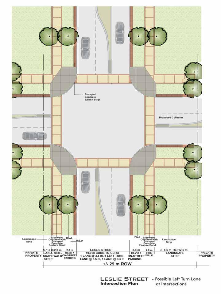
13 Typical Typical 8.0m 8.0m 8.0m Feature Band Varies According to Edge Condition 8.0m 8.0m 8.0m Typical 8.0m Property Line 8.0m Tree (ie. Honey Locust) PRIVATE with +/-1.5 m LAND- SIDE- BLVD + SCAPEWALKON-STREET 0.6 m Splash LESLIE STREET 10.0 m CURB-TO-CURB m, 1 LEFT TURN 3.5 m, m +/- 26 m ROW with BLVD + ON-STREET SIDE- WALK +/-5.5 m LANDSCAPE PRIVATE Leslie District scape Plan A-A Option 2 - Narrow Road Lanes - Slow Moving Traffic - On- Parking - Possible Left Turn Lane at Intersections (see Intersection Plan)
14 Typical Property Line PRIVATE +/-1.5 m LAND- SCAPE with BLVD + ON STREET 0.6 m Splash with Property Line LESLIE STREET 10.0 m CURB-TO-CURB m, 1 LEFT TURN 3.0 m, m +/- 26 m ROW +/-5.5 m BLVD + ON STREET LANDSCAPE PRIVATE Leslie District scape Section A-A Option 2 - Narrow Road Lanes - Slow Moving Traffic - On- Parking - Possible Left Turn Lane at Intersections
15 Typical Property Line PRIVATE +/-1.5 m LAND- SCAPE with On- Parking Patterned Surface ON-STREET LESLIE STREET 7.0 m CURB-TO-CURB m +/- 23 m ROW On- Parking Patterned Surface ON-STREET Property Line with +/-5.5 m LANDSCAPE PRIVATE Leslie scape Section A1-A1 Option 1 - Narrow Road Lanes - Slow Moving Traffic - On- Parking - Left Turn Lane at Intersections Only
16 Typical Property Line PRIVATE +/-1.5 m LAND- SCAPE with On- Parking Patterned Surface ON-STREET Property Line On- Parking Patterned Surface with LESLIE STREET 10.0 m CURB-TO-CURB m, 1 LEFT TURN 3.0 m, m +/- 26 m ROW ON-STREET +/-5.5 m LANDSCAPE PRIVATE Leslie scape Section A1-A1 Option 2 - Narrow Road Lanes - Slow Moving Traffic - On- Parking - Possible Left Turn Lane at Intersections


17 Typical 8.0m 8.0m 8.0m Typical Feature Band Varies According to Edge Condition 8.0m 8.0m 8.0m Typical Property Line 8.0m 8.0m Tree (ie. Honey Locust) PRIVATE with +/-1.5 m LAND- SIDE- BLVD + SCAPEWALKON-STREET 0.6 m Splash LESLIE STREET 7.0 m CURB-TO-CURB m +/- 26 m ROW +/- 30 m ROW with BLVD + ON-STREET SIDE- WALK +/-8.5 m TO +/-12.5 m LANDSCAPE PRIVATE Leslie scape Plan B-B Option 1 - Standard Road Lanes - On- Parking - Left Turn Lane at Intersections Only

 with +/-8.5 m TO 12.")
18 Typical Property Line +/-1.5 m LAND- SCAPE with BLVD + ON STREET 0.6 m Splash LESLIE STREET m 7.0 m CURB-TO-CURB +/- 26 m ROW +/- 30 m ROW Property Line (26 m ROW) Property Line (30 m ROW) with +/-8.5 m TO 12.5 m BLVD + ON STREET +/- LANDSCAPE Leslie scape Section B-B Option 1 - Standard Road Lanes - On- Parking - Left Turn Lane at Intersections Only
19 Typical 8.0m 8.0m 8.0m Typical Feature Band Varies According to Edge Condition 8.0m 8.0m 8.0m Typical Property Line 8.0m 8.0m Tree (ie. Honey Locust) with PRIVATE +/-1.5 m LAND- SIDE- BLVD + SCAPEWALKON-STREET 0.6 m Splash LESLIE STREET 10.0 m CURB-TO-CURB m, 1 LEFT TURN 3.5 m, m +/- 29 m ROW +/- 33 m ROW with BLVD + ON-STREET SIDE- WALK +/-8.5 m TO +/-12.5 m LANDSCAPE Leslie scape Plan B-B Option 2 - Standard Road Lanes - Possible Left Turn Lane at Intersections (see Intersection Plan) PRIVATE
20 Typical Property Line with +/-1.5 m LAND- SCAPE BLVD + ON STREET 0.6 m Splash LESLIE STREET 10.0 m CURB-TO-CURB m, 1 LEFT TURN 3.0 m, m +/- 29 m ROW +/- 33 m ROW Property Line (29 m ROW) with +/-8.5 m TO 12.5 m BLVD + ON STREET +/- LANDSCAPE Leslie scape Section B-B Option 2 - Standard Road Lanes - On- Parking - Possible Left Turn Lane at Intersections Property Line (33 m ROW)


21 Typical Property Line +/-1.5 m LAND- SCAPE with On- Parking Patterned Surface STREET LESLIE STREET 7.0 m CURB-TO-CURB m +/- 26 m ROW +/- 30 m ROW On- Parking Patterned Surface STREET with Property Line (26 m ROW) Property Line (30 m ROW) +/-8.5 m TO +/ m LANDSCAPE Leslie scape Section B1-B1 Option 1 - Standard Road Lanes - On- Parking - Left Turn Lanes at Intersections Only
22 Typical Property Line +/-1.5 m LAND- SCAPE with On- Parking Patterned Surface STREET LESLIE STREET 10.0 m CURB-TO-CURB m, 1 LEFT TURN 3.0 m, m +/- 29 m ROW +/- 33 m ROW On- Parking Patterned Surface STREET Property Line (29 m ROW) with +/-8.5 m TO +/ m LANDSCAPE Leslie scape Section B1-B1 Option 2 - Standard Road Lanes - On- Parking - Possible Left Turn Lane at Intersections Property Line (33 m ROW)
23


24 8.0m 8.0m 8.0m Feature Band 8.0m 8.0m 8.0m Bollard with Down Lights 8.0m Property Line 8.0m Property Line Tree (ie. Honey Locust) Property Line PRIVATE +/-1.75 m LAND- SCAPE with SIDE- WALK BLVD Splash 0.6 m LESLIE STREET m 6.4 m CURB-TO-CURB 21 m ROW 0.6 m 3.0 m WILD- FLOWER BED Cobblestone Sidewalk SIDE- WALK Lawn +/- LAND- SCAPE SHARON TEMPLE Leslie Sharon Temple Precinct( District) scape Plan C-C - Narrow Road Lanes - Slow Moving Traffic - No On- Parking
25 Property Line PRIVATE with +/-1.75 m LAND- SCAPE 0.6 m BLVD Splash -Post LESLIE STREET m 6.4 m CURB-TO-CURB 21 m ROW 0.6 m Cobblestone Sidewalk Lawn 3.0 m WILDFLOWER PLANTING BED +/- LAND- SCAPE SHARON TEMPLE Leslie scape Section Sharon Temple Precinct( District) - Narrow Road Lanes - Slow-Moving Traffic - No On- Parking


26 Property Line PRIVATE with +/-1.75 m LAND- SCAPE BLVD 0.6 m Splash -Post LESLIE STREET m 6.4 m CURB-TO-CURB 21 m ROW 0.6 m Property Line Cobblestone Sidewalk Lawn 3.0 m WILDFLOWER PLANTING BED +/- LAND- SCAPE SHARON TEMPLE Leslie scape Section Sharon Temple Precinct( District) - Night Time
 - Narrow Road Lanes - Slow-Moving")
27 Property Line CIVIC CENTRE LANDSCAPE Cobblestone Sidewalk Splash 0.6 m CIVIC CENTRE DRIVE m 6.4m CURB-TO-CURB 0.6 m Cobblestone Sidewalk Lawn 3.0 m WILDFLOWER PLANTING BED LANDSCAPE SHARON TEMPLE Civic Centre Drive scape Section Sharon Temple Precinct - Civic Centre Drive ( District) - Narrow Road Lanes - Slow-Moving Traffic - No On- Parking
28 Property Line Typical with WIDTH OF LANDSCAPE VARIES Grass BLVD Splash 0.6 m Grass with Property Line LESLIE STREET m 3.8 m MEDIAN 13.5 m CURB-TO-CURB BLVD WIDTH OF LANDSCAPE VARIES Intersection: Leslie + Civic Centre Drive scape Section E2-E2
29 Property Line Typical with +/- LAND- SCAPE Grass BLVD THROUGH TRAFFIC Splash LEFT-TURN LANE THROUGH TRAFFIC 0.6 m Grass with Property Line LESLIE STREET THROUGH TRAFFIC m LEFT-TURN 3.2 m 0.6 m CONCRETE MEDIAN 10.5 m CURB-TO-CURB BLVD +/- LAND- SCAPE Intersection: Leslie + Civic Centre Drive scape Section E2-E2
30
31 APPENDIX 4 Natural Evaluation Terms of Reference
32
33 Terms of Reference: Natural Evaluation The following are the general Terms of Reference for a Natural Evaluation (NHE) to determine the potential impacts on the Natural System (NHS) from development and site alteration proposals. The actual Terms of Reference for any particular application will be determined by the Town of East Gwillimbury in conjunction with the Lake Simcoe Region Conservation Authority. 1. Objectives The objectives of the Terms of Reference are as follows: 1.1 To provide an outline to applicants and their consultants of the expectations of an NHE, subject to a Terms of Reference meeting with the Town and the Authority. 1.2 To ensure that the required work and/or studies are known and agreed to prior to the commencement of work, to facilitate a cost-effective, stream-lined and timely review process. 2. General Policies 2.1 It is mandatory that the applicant and/or their consultant meet with the Town and the Conservation Authority to determine and agree upon the Terms of Reference of the NHE prior to the commencement of any work. 2.2 The NHE must be undertaken by a qualified professional in environmental or related sciences to the satisfaction of the Town and the Conservation Authority. 2.3 A visit to the site may be required by the Town and the Conservation Authority prior to, during, or upon receipt of the NHE. 2.4 The staking of regulated areas (i.e., wetlands, top of bank, etc.) and NHS features (i.e., woodlands, etc.) by the Authority may be required. Staking will generally occur between the end of May and the end of October. Any staking that occurs outside of this time may require a confirmatory visit between May and October. 3. Terms of Reference 3.1 Existing Conditions The existing conditions of the subject property must be clearly described and clearly mapped on aerial photographs.
34 3.1.2 The description must include the zoning and all designations of all Official Plans on and adjacent to the subject property. This includes any land use designations from other municipal planning documents, such as Secondary Plans Land use designations from any other applicable planning documents (i.e., Oak Ridges Moraine Conservation Plan, Greenbelt Plan) must be clearly described and the limits identified in the mapping The NHE shall identify the components of the Natural System and their respective Levels. The boundaries of the NHS shall be staked in the field by the proponent and approved by the Authority and the Town. The staked and surveyed boundaries shall be provided on a figure in the report All designated environmental features (i.e., the NHS or natural features identified in the OPs) must be identified in the mapping and described in the report. These features include provincial or regional Areas of Natural and Scientific Interest (ANSIs), Provincially Significant Wetlands (PSWs), etc The vegetation communities must be identified using the Ecological Land Classification (ELC) system to vegetation type. The communities must be identified in the mapping, using the appropriate ELC codes, as well as described in the text. A three-season survey may be required As a component of the ELC, a plant list with common and scientific names must be included as an appendix. The list must include an analysis for the presence of federal, provincial, regional and/or watershed rare, threatened or endangered species. This should include information from the MNR district office and NHIC The NHE may require a breeding bird survey. The need for such a survey will be determined as part of the initial Terms of Reference/scoping meeting. The survey must be conducted during the breeding bird season at an appropriate time of day in appropriate weather conditions and by a qualified professional. A minimum of two surveys are required and they must follow generally accepted scientific protocols, not necessarily atlassing methods A list of the breeding birds is required as an appendix. The list must include an analysis for the presence of federal or provincial rare, threatened or endangered species. Watershed rarity status shall be determined in conjunction with the Conservation Authority The NHE may require a breeding amphibian/reptile survey. The survey must be conducted during the breeding amphibian season and by a qualified professional. For calling amphibians a minimum of three surveys are required. These surveys must span the full amphibian breeding season to ensure that the peak periods of
35 activity for early and late breeding species are accounted for. For non-calling amphibians, appropriate methodology must be used A list of the breeding amphibians is required as an appendix. The list must include an analysis for the presence of federal, provincial, threatened or endangered species. Watershed rarity status shall be determined in conjunction with the Conservation Authority If any watercourses or waterbodies identified in the NHS as habitat for fish are present, a fisheries assessment shall be provided. Existing data regarding fish species shall be obtained from LSRCA and/or the MNR. Where necessary, fish will be sampled through electrofishing and/or netting during the appropriate season, under a collection permit issued by the Ministry of Natural Resources. The assessment shall include a description of watercourses or other fish habitat on and/or adjacent to the property All incidental wildlife observed shall be reported on and listed in an appendix. The list must include an analysis for the presence of federal or provincial rare, threatened or endangered species. Watershed rarity status shall be determined in conjunction with the conservation authority A functional assessment of the subject property describing the ecology of the natural heritage features and functions should be provided. This shall include a consideration of the hydrological requirements of natural heritage features, particularly wetlands Where the NHS has identified a stream linkage or potential proximity linkage on or adjacent to the property, the NHE must identify the location, width and proposed vegetation composition of the linkage. Once the limits of the linkage have been determined to the satisfaction of the Town and the Conservation Authority, these shall be staked in the field and subsequently surveyed Mapping (at a minimum) shall consist of the following: a) All mapping must have a title, figure number, north arrow, legend and scale or scale bar. b) A site location map that provides the regional or watershed context of the subject property. c) The extent of the Natural System and its components must be clearly demarcated on an orthophoto base. d) The locations of all watercourses and waterbodies and an indication of their flow and thermal regimes.
36 e) Vegetation communities must be delineated and identified using ELC. f) The location of any rare, threatened or endangered species and/or populations shall be identified. g) The location of any important wildlife features (i.e., hibernacula, den, stick nest, etc.) shall be identified. 3.2 Assessment of Impacts The potential impacts to the features and functions of the Natural System shall be identified and discussed An assessment of the potential impact on wildlife at a local, watershed and provincial (if applicable) level shall be provided In the case of a Core Area feature, the NHE must demonstrate that there is no development or site alteration within the feature or negative impacts. The NHE must determine appropriate buffers from Core Area features through the identification of critical function and protection zones In the case of Supporting Area features, the NHE must demonstrate no net negative impacts on the natural features or ecological functions, which may involve the identification of buffers from Supporting Area features and other mitigation measures A description of the natural features proposed for removal shall be provided. The quantity of removal shall also be included An assessment of the potential impact on the Natural System, including any Linkages areas that have been identified. 3.3 Recommendations and Mitigation Measures Avoidance of any NHS feature, regardless of its assigned level, is the preferred approach to mitigation. In the case of Core Area features, avoidance is required Determine adequate buffers through the identification of the critical function and protection zones of the NHS Where avoidance of a feature is not feasible or possible, mitigation approaches/techniques must be provided. These may include edge management plans, buffer plantings, fencing, etc In cases where a Linkage area has been identified on a property, the NHE must demonstrate how it will be integrated into the proposed development plan.
37 3.3.4 Recommendations for Best Management Practices during construction should be provided. This may include silt fencing, tree protection, fencing, identification of timing or seasonal constraints to construction or restoration, etc Mitigation for negative impacts on the natural features or their ecological functions (or to achieve no net negative impact) may include, at the discretion of the Town in conjunction with the LSRCA, approaches to replace lost areas or functions If acceptable, replacement shall, to the extent possible, occur within the same subwatershed as the proposed development or site alteration The appropriate amount of replacement will be determined through discussions with the Authority and the Town and will be agreed to by all parties in writing If monitoring is required, the details of a monitoring program must be agreed to in writing by the Town, LSRCA and other parties. 3.4 Conclusions The NHE must demonstrate the following: No development or site alteration within Core Area features No net negative impacts to Supporting Area features Conformity with the policies and requirements of the Official Plan(s) Conformity with the policies and requirements of other applicable planning documents (i.e., ORMCP, Greenbelt Plan, etc) Conformity with the requirements of the LSRCA s Watershed Development Policies
38
39 APPENDIX 5 Schedule 3 (Severely Toxic Contaminants) to Regulation 347 of the Revised Regulations of Ontario, 199
40
41 SCHEDULE 3 SEVERELY TOXIC CONTAMINANTS Severely Toxic Contaminants Regulated Constituent Land Disposal Treatment Requirements Aqueous Waste Non-aqueous Waste Column 1 Column 2 Column 3 Column 4 Column 5 Column 6 Column 7 Haz. Waste Number 1 CAS Number 2 Contaminant Generic Name or other description CAS Number 2 Concentration 3 (mg/l) Concentration 4 (mg/kg) S Aflatoxin NA NA NA NA S ,3,7,8- Tetrachlorodibenzo-pdioxin TCDDs (All Tetrachlorodibenzo-p-dioxins) S ,2,3,7,8- Pentachlorodibenzo-pdioxin S ,2,3,4,7,8- Hexachlorodibenzo-pdioxin S ,2,3,6,7,8- Hexachlorodibenzo-pdioxin S ,2,3,7,8,9- Hexachlorodibenzo-pdioxin PeCDDs (All Pentachlorodibenzo-pdioxins) HxCDDs (All Hexachlorodibenzo-pdioxins) HxCDDs (All Hexachlorodibenzo-pdioxins) HxCDDs (All Hexachlorodibenzo-pdioxins) S ,3,7,8- TCDFs (All Tetrachlorodibenzofurans) Tetrachlorodibenzo furan Notes to Schedule 3: 1 Haz. Waste Number means Hazardous Waste Number. These numbers are consistent with United States Environmental Protection Agency Hazardous Waste Numbers. If there is no United States Environmental Protection Agency Hazardous Waste Number for a waste, the Hazardous Waste Number is assigned to the waste by the Ontario Ministry of the Environment. 2 CAS Number means the Chemical Abstracts Service Registry Number. When the waste or a regulated constituent is described as a combination of a chemical with its salts or esters, the CAS number is given for the parent compound only. 3 Concentration requirements for aqueous wastes are based on analysis of composite samples. 4 Concentration requirements for non-aqueous wastes are based on analysis of grab samples.
AMENDMENT NO. 30 TO THE OFFICIAL PLAN OF THE TOWN OF MILTON
 AMENDMENT NO. 30 TO THE OFFICIAL PLAN OF THE TOWN OF MILTON Subject: Boyne Survey Secondary Plan and Related Official Plan Amendments The following text and schedules constitute Amendment No. 30 to the
6 Growth Management Challenges and Opportunities
 6 Growth Management Challenges and Opportunities The Town has established a goal of attaining a 50% participation rate with respect to employment opportunities versus residential population. The Town s
TRCA Field Staking Protocol December 2016
 Page 1 of 6 TRCA Field Staking Protocol December 2016 This Protocol describes TRCA staff s current practice for field staking the physical top of bank, the physical toe of slope, and the limit of existing
TERRESTRIAL NATURAL HERITAGE SYSTEM STRATEGY APPENDIX F: MODEL POLICIES FOR THE IMPLEMENTATION OF THE TARGET TERRESTRIAL NATURAL HERITAGE SYSTEM
 TERRESTRIAL NATURAL HERITAGE SYSTEM STRATEGY APPENDIX F: MODEL POLICIES FOR THE IMPLEMENTATION OF THE TARGET TERRESTRIAL NATURAL HERITAGE SYSTEM C H A P T E R 1 M O D E L P O L I C I E S F O R I M P L
Township of Adjala-Tosorontio Official Plan Review. Natural Heritage
 Township of Adjala-Tosorontio Official Plan Review 13 Natural Heritage Introduction What is an Official Plan? An official plan is a municipal policy document which sets out the community s vision and strategies
Summary of Changes for the Comprehensive Draft Proposed Official Plan Amendment
 Summary of Changes for the Comprehensive Draft Proposed Official Plan Amendment Note: Due to the broad scope of the Official Plan Review, this list is not exhaustive of the extent of changes in the comprehensive
APPENDIX 1: SCOPED ENVIRONMENTAL IMPACT STATEMENT (EIS) FORM
 FORM") APPENDIX 1: SCOPED ENVIRONMENTAL IMPACT STATEMENT (EIS) FORM This form is intended for use by applicants (primarily private landowners) who need to conduct a Scoped EIS in support of minor development
APPENDIX 1: SCOPED ENVIRONMENTAL IMPACT STATEMENT (EIS) FORM This form is intended for use by applicants (primarily private landowners) who need to conduct a Scoped EIS in support of minor development
CONSULTING SERVICES FOR THE WHITEBELT VISIONING EXERCISE ADDENDUM TO THE GTA WEST LAND USE STUDY WORK PROGRAM
 CONSULTING SERVICES FOR THE WHITEBELT VISIONING EXERCISE ADDENDUM TO THE GTA WEST LAND USE STUDY 1. Introduction WORK PROGRAM The Town of Caledon is a large, local municipality located in the Greater Toronto
13. VANDORF-PRESTON LAKE SECONDARY PLAN 13.1 INTRODUCTION
 13. VANDORF-PRESTON LAKE SECONDARY PLAN 13.1.1 Purpose 13.1 INTRODUCTION The Vandorf-Preston Lake Secondary Plan establishes the principles, objectives and general policies, as well as specific strategies
Peel Region. Greenbelt Plan Conformity. Plan Review. Background & Approach
 Peel Region Plan Review Background & Approach Greenbelt Plan Conformity November 2008 Page 2 of 13 2 COMMENT SHEET Region of Peel Greenbelt Plan Policy Review This comment sheet is to be used to provide
Planning for the Future Urban Area. in north Markham. Update. Development Services Committee. December 9, De Development Services Committee
 Planning for the in north Markham 1 Update De December 9, 2014 Overview - Growth Management Strategy and new Official Plan 2014 Status - Official Plan 2014 and ROPA3 Update - Planning for the Future Urban
OFFICIAL PLAN FOR THE TOWN OF NEW TECUMSETH
 OFFICIAL PLAN FOR THE TOWN OF NEW TECUMSETH Approved by Simcoe County- March 10, 2010 TABLE OF CONTENTS PAGE# 1.0 TITLE AND COMPONENTS... 5 2.0 INTRODUCTION... 6 2.1 Purpose... 6 2.2 Organization of the
THE CORPORATION OF THE CITY OF WINDSOR Office of the City Solicitor Planning Department
 THE CORPORATION OF THE CITY OF WINDSOR Office of the City Solicitor Planning Department REPORT TO THE CITY OF WINDSOR PLANNING ADVISORY COMMITTEE DATE OF REPORT: August 19, 2010 SUBJECT: Official Plan
1 Introduction. Chapter. In this chapter:
 Chapter 1 Introduction In this chapter: 1.1 A Snapshot of the Region 1.2 Towards a Sustainable Region 1.3 The Provincial Context 1.4 Purpose and Organization The Regional Municipality of York Official
Sharon Village Block Plan
 Sharon Village Block Plan February, 2010 SHARON Malone Given Parsons Ltd. NAK Design Group MMM Group [This page intentionally left blank] Table of Contents 1.0 Introduction 1-1 1.1 Overview 1-1 1.2 Community
Central Lake Ontario Conservation Conservation Lands Master Plan
 Conservation Lands Master Plan Top 13 Frequently Asked Questions 1. What are conservation lands? Where are these conservation lands located in the Central Lake Ontario Conservation watershed? Conservation
NEW REGIONAL OFFICIAL PLAN HIGH LEVEL PROCESS & FRAMEWORK
 NEW REGIONAL OFFICIAL PLAN HIGH LEVEL PROCESS & FRAMEWORK Why A New Official Plan Originally the role of Regionally Planning and content of Regional Official Plan (1970s) primarily focused on protecting
The protection of the agricultural resources of the Province;
 PART II INTRODUCTION An Official Plan is a policy document, which is intended to serve as the basis for making land use decisions and managing change in any municipality in Ontario. According to the Planning
AMENDMENT NO. 38 TO THE CITY OF BARRIE OFFICIAL PLAN SALEM SECONDARY PLAN. June 2014
 AMENDMENT NO. 38 TO THE CITY OF BARRIE OFFICIAL PLAN SALEM SECONDARY PLAN June 2014 AMENDMENT NO. 38 TO THE OFFICIAL PLAN OF THE BARRIE PLANNING AREA TABLE OF CONTENTS Page Introduction 1 Part A - The
Environment and Sustainability. Environment and Sustainability
 4 Environment and Sustainability Environment and Sustainability ENVIRONMENT AND SUSTAINABILITY 4.1 CLIMATE CHANGE AND AIR QUALITY... 4-5 4.1.1 OBJECTIVES... 4-6 4.1.2 POLICIES... 4-6 4.2 NATURAL HERITAGE
12 AMENDMENT NO. 149, TOWN OF MARKHAM HIGHWAY 404 NORTH SECONDARY PLAN
 12 AMENDMENT NO. 149, TOWN OF MARKHAM HIGHWAY 404 NORTH SECONDARY PLAN The Planning and Economic Development Committee recommends the adoption of the recommendation contained in the following report August
Official Plan Review
 Official Plan Review Summary Report - The Built Environment August 2014 Part 1: Introduction Planning for a healthy, prosperous and sustainable community is an important goal for our municipality. From
3 Development Process 3.1 Stage One page Stage Two page Stage Three page CENTRAL PICKERING DEVELOPMENT PLAN
 3 Development Process 3.1 Stage One page 24 3.2 Stage Two page 25 3.3 Stage Three page 28 22 CENTRAL PICKERING DEVELOPMENT PLAN The Central Pickering Development Plan establishes the key elements of new
2 STATUTORY PUBLIC MEETING AND INFORMATION REPORT FOR PUBLIC MEETING ON AMENDMENT NO. 62 TO THE YORK REGION OFFICIAL PLAN
 2 STATUTORY PUBLIC MEETING AND INFORMATION REPORT FOR PUBLIC MEETING ON AMENDMENT NO. 62 TO THE YORK REGION OFFICIAL PLAN Pursuant to Section 17(15) of the Planning Act, as amended, the Regional Planning
The West Vaughan Employment Area Secondary Plan Policies
 Part 2: The West Vaughan Employment Area Secondary Plan Policies 2.1 General Policies It is the policy of Council: 2.1.1. That the West Vaughan Employment Area (the WVEA), identified on Schedule 1, will
Master Environmental Servicing Plan & Secondary Plan
 East Side Lands Stage 2 1 Master Environmental Servicing Plan & Secondary Plan Public Information Centre #1 June 16, 2016 Welcome! Today s Agenda Please sign in at the front desk. 5:30 pm 6:30 pm: Open
AMENDMENT NO. 41 TO THE OFFICIAL PLAN FOR THE TOWN OF MONO
 AMENDMENT NO. 41 TO THE OFFICIAL PLAN FOR THE TOWN OF MONO This Amendment to the Official Plan for the Town of Mono, which has been adopted by the Corporation of the Town of Mono, is hereby approved in
DRAFT. & Secondary Plan Study. East Side Lands- Stage 2. Planning Rationale Report
 East Side Lands- Stage 2 Master Environmental SERVICING Plan & Secondary Plan Study Planning Rationale Report Draft April 24, 2018 QUALITY MANAGEMENT Issue/Revision First Issue Revision 1 Revision 2 Remarks
THE REGIONAL MUNICIPALITY OF PEEL BY-LAW NUMBER
 - 1 - THE REGIONAL MUNICIPALITY OF PEEL BY-LAW NUMBER 34-2010 A by-law to adopt Regional Official Plan Amendment Number 24 to the Region of Peel Official Plan in order to amend policies related to Growth
Cc~tporate Sers~ic:es
 tg * Cc~tporate Sers~ic:es Csrmcil and Adnrirristrativs Services April 26,201 1 ". RE(;lr?N (1;. 1q.1 i Town of Caledon Region of Peel ci E~iliS DEP? Attn: Karen Landry, Director of Attn: Carol Reig, Regional
RECOMMENDED DIRECTIONS REPORT FOR THE TOWN OF RICHMOND HILL
 RECOMMENDED DIRECTIONS REPORT ENVIRONMENTAL POLICY REVIEW FOR THE TOWN OF RICHMOND HILL Prepared for: Town of Richmond Hill 225 East Beaver Creek Road Richmond Hill, ON, L4B 3P4 Prepared by: SENES Consultants
July 9, Adèle Labbé Environmental Planner City of Guelph 1 Carden Street Guelph, Ontario N1H 3A1. Dear Ms. Labbé.
 July 9, 2014 Adèle Labbé Environmental Planner City of Guelph 1 Carden Street Guelph, Ontario N1H 3A1 Dear Ms. Labbé. Re: 132 Clair Road West EIS Terms of Reference North-South Environmental Inc. (hereafter,
THE CORPORATION OF THE TOWN OF OAKVILLE BY-LAW NUMBER
 THE CORPORATION OF THE TOWN OF OAKVILLE BY-LAW NUMBER 20012-08530 A by-law to adopt an amendment to the Official Plan of the Oakville Planning Area (Official Plan Amendment 198) Land North of Dundas Street.
OFFICIAL PLAN of the TOWN of BRADFORD WEST GWILLIMBURY Adopted February 15, 2000
 OFFICIAL PLAN of the TOWN of BRADFORD WEST GWILLIMBURY Adopted February 15, 2000 OFFICE CONSOLIDATION (Consolidated to October 1, 2002) J. Ross Raymond & Associates Ltd Gravenhurst, Ontario Building Community
9 CITY OF VAUGHAN OFFICIAL PLAN AMENDMENT NO BOCA EAST INVESTMENTS LIMITED
 9 CITY OF VAUGHAN OFFICIAL PLAN AMENDMENT NO. 631 - BOCA EAST INVESTMENTS LIMITED The Planning and Economic Development Committee recommends the adoption of the recommendations contained in the following
Town of Newmarket 395 Mulock Drive P.O. Box 328, Newmarket, Ontario, L3Y 4X7. Website: newmarket.ca Phone:
 Town of Newmarket 395 Mulock Drive P.O. Box 328, Newmarket, Ontario, L3Y 4X7 Email: info@newmarket.ca Website: newmarket.ca Phone: 905-895-5193 Natural Heritage System Boundary Refinement: Vacant Lot West
The lands identified as Residential Areas on Schedule A1, Urban Structure, represent the areas that provide for stable residential communities.
 Livable Oakville Part D: Land Use Designations and Policies 11. RESIDENTIAL 11.1 General The lands identified as Residential Areas on Schedule A1, Urban Structure, represent the areas that provide for
AMENDMENT NO. 2 TO THE TRENT HILLS OFFICIAL PLAN
 The Municipality of Trent Hills Official Plan AMENDMENT NO. 2 TO THE TRENT HILLS OFFICIAL PLAN Adopted by Council on Approved by the Ministry of Municipal Affairs and Housing on Version Date: November
APPENDIX I Presentations
 APPENDIX I Presentations Workshop Summary Report 11 Peel Region Official Plan Review May 5, 2010 Compatible Active Recreation Workshop July 29, 2010 Components of PROPR Sustainability Planning Tools/Updates
3-2 Environmental Systems
 3-2 Environmental Systems 3.0 ENVIRONMENTAL SYSTEMS CONTENTS 3.1 GREENWAY SYSTEM 3.1.1 General Policies 3.1.2 Natural Heritage Network 3.1.3 Natural Heritage Network Enhancement Lands 3.1.4 Rouge Watershed
Feasibility Analysis for Expansion of the Provincial Greenbelt Plan Area into Mississauga
 Feasibility Analysis for Expansion of the Provincial Greenbelt Plan Area into Mississauga November 8, 2013 Natural Heritage and Urban Forest Strategy: Draft Discussion Paper #3: Table of Contents 1.0 Introduction...
B R I E F A p p e n d i x A : F i g u r e s
 HALTON MUNICIPALITIES BRIEF: APPENDIX A 1 B R I E F A p p e n d i x A : F i g u r e s 2 0 1 6 Halton Municipalities Regional Municipality of Halton Corporation of the City of Burlington Corporation of
A Growing Community Rural Settlement Areas
 Town of Huntsville Official Plan Review - POLICY BACKGROUND PAPER A Growing Community Rural Settlement Areas BACKGROUND: In addition to the fully municipally-serviced Urban Settlement Area and the Hidden
Leonard s Beach Secondary Plan (Alcona North) Official Plan Amendment
 Official Plan Amendment") Leonard s Beach Secondary Plan (Alcona North) Official Plan Amendment Public Meeting Presentation August 14, 2013 Note: This document is for presentation purposes only. Please see Staff Report DSR-135-13
Leonard s Beach Secondary Plan (Alcona North) Official Plan Amendment Public Meeting Presentation August 14, 2013 Note: This document is for presentation purposes only. Please see Staff Report DSR-135-13
AMENDMENT NO. 107 TO THE CLARINGTON OFFICIAL PLAN ADOPTED BY CLARINGTON COUNCIL NOVEMBER 1, 2016
 AMENDMENT NO. 107 TO THE CLARINGTON OFFICIAL PLAN ADOPTED BY CLARINGTON COUNCIL NOVEMBER 1, 2016 Purpose The purpose and effect of the Recommended Official Plan Amendment No. 107 is to bring the Clarington
1.0 INTRODUCTION AND BACKGROUND
 1.0 INTRODUCTION AND BACKGROUND 1.1 INTRODUCTION / BACKGROUND The Regional Municipality of York (hereafter referred to as York Region ) has completed a Municipal Class Environmental Assessment (Class EA)
New Official Plan Quest November 2013
 City of Markham New Official Plan Quest November 2013 Building Markham s Future Together - 6 Key Strategic Priorities 1. Growth - Managing our Growth 2. Transportation/Transit - Improving transportation
Richmond Hill Official Plan PART II SECONDARY PLANS
 9 N O R T H L E S L I E Richmond Hill Official Plan PART II SECONDARY PLANS TABLE OF CONTENTS 9.0 THE NORTH LESLIE SECONDARY PLAN 9-3 Basis The Development Concept 9.1 Introduction 9-4 9.2 Purpose 9-4
Toronto Complete Streets Guidelines
 Toronto Complete Streets Guidelines 108 110 7.1 Green Infrastructure Design Principles 112 7.2 Context-Sensitive Green Streets 114 7.3 Key Green Street Elements Green infrastructure refers to natural and
AMENDMENT NO. TO THE CITY OF BARRIE OFFICIAL PLAN HEWITT S SECONDARY PLAN
 AMENDMENT NO. TO THE CITY OF BARRIE OFFICIAL PLAN HEWITT S SECONDARY PLAN OFFICIAL PLAN FOR THE CITY OF BARRIE Amendment No. Amendment No. to the was prepared by the Barrie General Committee and was recommended
Heritage Road Improvements from Steeles Avenue to Rivermont Road
 The Corporation of the City of Brampton Heritage Road Improvements from Steeles Avenue to Rivermont Road Class Environmental Assessment Study (Schedule C) September 19, 2013 The Corporation of the City
Infrastructure, Development and Enterprise Services. Natural Heritage Action Plan (NHAP) Project Initiation
 Project Initiation") Staff Report To Service Area Committee of the Whole Infrastructure, Development and Enterprise Services Date Monday, March 6, 2017 Subject Natural Heritage Action Plan (NHAP) Project Initiation Report
Staff Report To Service Area Committee of the Whole Infrastructure, Development and Enterprise Services Date Monday, March 6, 2017 Subject Natural Heritage Action Plan (NHAP) Project Initiation Report
4. What are the goals of the Kawarthas, Naturally Connected project? 7. What are watersheds and why are they being used as the project boundaries?
 Frequently Asked Questions (FAQs) 1. What are Natural Heritage Systems (NHS)? 2. Why are they important? 3. Which areas of the province have undertaken NHS projects? 4. What are the goals of the Kawarthas,
FORMER CANADIAN FORCES BASE (CFB) ROCKCLIFFE SECONDARY PLAN. Official Plan Amendment XX to the Official Plan for the City of Ottawa
 ROCKCLIFFE SECONDARY PLAN. Official Plan Amendment XX to the Official Plan for the City of Ottawa") FORMER CANADIAN FORCES BASE (CFB) ROCKCLIFFE SECONDARY PLAN Official Plan Amendment XX to the Official Plan for the City of Ottawa 1 INDEX THE STATEMENT OF COMPONENTS PART A THE PREAMBLE PAGE Purpose...
FORMER CANADIAN FORCES BASE (CFB) ROCKCLIFFE SECONDARY PLAN Official Plan Amendment XX to the Official Plan for the City of Ottawa 1 INDEX THE STATEMENT OF COMPONENTS PART A THE PREAMBLE PAGE Purpose...
TOWN OF SAUGEEN SHORES OFFICIAL PLAN
 TOWN OF SAUGEEN SHORES OFFICIAL PLAN Adopted by Council: December 10, 2012 Approved by County of Bruce: March 26, 2014 (Office Consolidation September 2014) Town of Saugeen Shores 1 Table of Contents Saugeen
2.5.1 Mineral aggregate resources shall be protected for long-term use
 2.5 MINERAL AGGREGATE RESOURCES 2.5.1 Mineral aggregate resources shall be protected for long-term use 2.5.2 Protection of Long-Term Resource Supply 2.5.2.1 As much of the mineral aggregate resources as
PORT WHITBY COMMUNITY
 PORT WHITBY COMMUNITY SECONDARY PLAN UPDATE COMMUNITY IMPROVEMENT PLAN URBAN DESIGN GUIDELINES September 2015 DRAFT PROPOSED AMENDMENT NUMBER # to the Whitby Official Plan PURPOSE: The intent of this Amendment
Complete Neighbourhood Guidelines Review Tool
 Complete Neighbourhood Guidelines Review Tool Prepared By: City of Regina Planning Department October 2014 Page 1 of 14 Community Development Review Checklist for Secondary Plans and Concept Plans The
Background Summary Report
 Background Summary Report May 2014 Submitted by Macaulay Shiomi Howson Ltd. In association with AMEC MMM Group Brook McIlroy Inc. Hemson Consulting Ltd. Table of Contents 1. Introduction... 1 2. Why is
TORONTO COMPLETE STREETS GUIDELINES
 TORONTO COMPLETE STREETS GUIDELINES Presentation by Fiona Chapman, Manager, Pedestrian Projects Public Realm Section, Transportation Services, City of Toronto June 2017 PURPOSE OF THE PROJECT To develop
SECTION E. Realizing the Plan
 SECTION E Realizing the Plan 60 DESIGN REGINA - OFFICIAL COMMUNITY PLAN SECTION E Realizing the Plan Design Regina has been an ambitious plan-making exercise, with a high level of community, stakeholder,
CITY OF VAUGHAN EXTRACT FROM COUNCIL MEETING MINUTES OF NOVEMBER 15, 2016
 Item 11, Report No. 38, of the Committee of the Whole, which was adopted without amendment by the Council of the City of Vaughan on November 15, 2016. Regional Councillor Di Biase declared an interest
CITY OF VAUGHAN EXTRACT FROM COUNCIL MEETING MINUTES OF DECEMBER 10, 2013
 Item 1, Report No. 55, of the Committee of the Whole (Working Session), which was adopted without amendment by the Council of the City of Vaughan on December 10, 2013. Regional Councillor Di Biase declared
Rapid Transit Implementation Working Group September 14, 2017
 Rapid Transit Implementation Working Group September 14, 2017 BACKGROUND Council approved the Rapid Transit Master Plan and Updated Business Case on July 25, 2017. Approval of the RTMP confirmed the BRT
Integration of Trees into Roads Policy - the road to success -
 Integration of Trees into Roads Policy - the road to success - Trees, People and the Built Environment 3 City of Birmingham, UK April 5 th, 2017 Ian Buchanan Natural Heritage and Forestry Regional Municipality
Tremaine Dundas Secondary Plan (Draft May 2017)
") PB-52-17 Appendix A Tremaine Dundas Secondary Plan (Draft May 2017) Page 2 Tremaine Dundas Secondary Plan (Draft May 2017) This page has been left blank intentionally Page 3 Tremaine Dundas Secondary Plan
PB-52-17 Appendix A Tremaine Dundas Secondary Plan (Draft May 2017) Page 2 Tremaine Dundas Secondary Plan (Draft May 2017) This page has been left blank intentionally Page 3 Tremaine Dundas Secondary Plan
Figure 1- Site Plan Concept
 Figure 1- Site Plan Concept Parking will be provided underground on three levels at rate of 1.0 space/ unit; this rate includes all visitors parking. MMM Group has prepared a parking assessment (April,
DISCUSSION PAPER INFRASTRUCTURE
 Town of Penetanguishene DISCUSSION PAPER INFRASTRUCTURE OCTOBER 2016 Working Draft Contents 1. Introduction... 1 2. Water, Sewer and Stormwater... 1 2.1. Provincial Policy Statement, 2014... 1 2.2. Growth
A Proposed Modelling and Scenariobased Approach for Identifying Natural Heritage Systems in Southern Ontario Discussion Paper
 A Proposed Modelling and Scenariobased Approach for Identifying Natural Heritage Systems in Southern Ontario Discussion Paper Ministry of Natural Resources Draft - October 2006 Executive Summary Under
Elfrida Growth Area Study
 Elfrida Growth Area Study Public Information Centre #2 December 6, 2017 6:00-8:30 pm PLANNING & ECONOMIC DEVELOPMENT DEPARTMENT Purpose of the Study The Elfrida Area has been identified as the preferred
Sustainable Natural Environment Wetlands
 Town of Huntsville Official Plan Review - POLICY BACKGROUND PAPER Sustainable Natural Environment Wetlands BACKGROUND: Wetlands are an important natural resource. The ecological, social and economic benefits
KING CITY COMMUNITY PLAN
 KING CITY COMMUNITY PLAN TOWNSHIP OF KING JANUARY 27, 2000 AMENDMENT NO. 54 to the OFFICIAL PLAN for the TOWNSHIP OF KING PLANNING AREA THE COMMUNITY PLAN TABLE OF CONTENTS PAGE PART 1 INTRODUCTION 1.1
11. BALLANTRAE-MUSSELMAN LAKE AND ENVIRONS SECONDARY PLAN
 11. BALLANTRAE-MUSSELMAN LAKE AND ENVIRONS SECONDARY PLAN 11.1 PURPOSE The Ballantrae-Musselman Lake and Environs Secondary Plan Area includes two small existing settlement areas, Ballantrae and Musselman
Planning Justification Report. Milton Meadows Properties Ltd. Milton Meadows South IN SUPPORT OF ZONING BY-LAW AMENDMENT & DRAFT PLAN OF SUBDIVISION
 Planning Justification Report Milton Meadows Properties Ltd. Milton Meadows South IN SUPPORT OF ZONING BY-LAW AMENDMENT & DRAFT PLAN OF SUBDIVISION For Part of Lot 3, Concession 1 Town of Milton HUMPHRIES
MAYFIELD WEST SECONDARY PLAN PHASE 2
 MAYFIELD WEST SECONDARY PLAN PHASE 2 Council Information Workshop February 16, 2010 Draft Preferred Land Use Plan TOWN OF CALEDON PLANNING & DEVELOPMENT DEPARTMENT Workshop Agenda TOWN OF CALEDON 1. Welcome
Planning Justification Report
 Planning Justification Report Application for Draft Plan of Subdivision, Official Plan Amendment and Zoning Bylaw Amendment for Lift of Hold Proposed Residential Development Part of Lots 34 & 35, Concession
APPENDIX F: EXTERNAL APPROVALS
 1.0 RESPONSIBILITIES When the City is constructing the Park or Open Space Development lands (OPTION I), after the subdivision construction process is completed by the Developer, Open Space Development
SUBJECT: GO Station Mobility Hubs Preferred Concepts: Aldershot GO, Burlington GO and Appleby GO. Planning and Development Committee - Public Meeting
 Page 1 of Report PB-76-17 SUBJECT: GO Station Mobility Hubs Preferred Concepts: Aldershot GO, Burlington GO and Appleby GO TO: FROM: Planning and Development Committee - Public Meeting Planning and Building
PDS June 1, 2016 Page 1. Planning and Development Committee. MEETING DATE: Wednesday, June 01, 2016
 Page 1 REPORT TO: Planning and Development Committee MEETING DATE: Wednesday, June 01, 2016 SUBJECT: ROPA 12: Project Initiation Report Regional Official Plan Amendment (ROPA # 12) Watercourse Policies
SUBJECT: Revised proposed new official plan recommended for adoption
 Page 1 of Report PB-04-18 SUBJECT: Revised proposed new official plan recommended for adoption TO: FROM: Planning and Development Committee Department of City Building Report Number: PB-04-18 Wards Affected:
Planning Department. Director of Planning. Manager of Planning. Planning Technician/ Sustainability Coordinator. Planner II/ Heritage Coordinator
 Department Director of Manager of Policy Planner Planner II (2) Planner II/ Heritage Coordinator Technician/ Sustainability Coordinator Technician Administrative Clerk March 2017 Department 2018 Business
Bostwick Road. Municipal Class Environmental Assessment. October 13, City of London. Bostwick Road Municipal Class Environmental Assessment
 Bostwick Road Municipal Class Environmental Assessment October 13, 2016 Welcome! Welcome to the first Public Information Centre for the Bostwick Road Municipal Class Environmental Assessment. Representatives
Lower Don River West Remedial Flood Protection Project TABLE OF CONTENTS. Page. Executive Summary
 TABLE OF CONTENTS Page Executive Summary 1.0 INTRODUCTION...1-1 1.1 Purpose of the Undertaking...1-1 1.2 Study Area Description...1-1 1.3 Description of the Undertaking...1-1 1.4 Rationale for the Undertaking...1-2
This page has been intentionally left blank.
 This page has been intentionally left blank. Chapter 3 3-2 3. Employment 3.A Niagara Economic Gateway 3.A.1 General The Niagara Economic Gateway comprises: a) The Gateway Economic Zone which includes all
Proposed Kenmount Hill CDS Amendment. Public Hearing October 25 th, 2018
 Proposed Kenmount Hill CDS Amendment Public Hearing October 25 th, 2018 History of Kenmount Hill Why Kenmount Hill? Why Now? We are a city with a vision for growth and the development of Kenmount Hill
North Oakville East Parks Facilities Distribution Plan. November, 2009
 North Oakville East November, 2009 POLICY CONTEXT 1) Purpose a) The purpose of this document is to be a guide for the location, configuration, design and development of the parks system for the North Oakville
13 THORNHILL YONGE STREET STUDY IMPLEMENTATION CITY OF VAUGHAN OPA 669 AND TOWN OF MARKHAM OPA 154
 13 THORNHILL YONGE STREET STUDY IMPLEMENTATION CITY OF VAUGHAN OPA 669 AND TOWN OF MARKHAM OPA 154 The Planning and Economic Development Committee recommends the adoption of the recommendations contained
Population, Housing, and Employment Analysis
 Population, Housing, and Employment Analysis Reviewed housing development patterns, trends, needs, affordability, and estimated employment and population capacity at full build out. Total 28,200 people
CITY OF NIAGARA FALLS. By-law No
 CITY OF NIAGARA FALLS By-law No. 2018- A by-law to provide for the adoption of Amendment No. 128 to the City of Niagara Falls Official Plan (OPA #128). THE COUNCIL OF THE CORPORATION OF THE CITY OF NIAGARA
McKay Road Interchange and Salem / Lockhart Crossing
 McKay Road Interchange and Salem / Lockhart Crossing The McKay Road Interchange Class EA has two components: 1. A new MacKay Road Interchange at Highway 400; and 2. A new bridge crossing of Highway 400
HAZARD MITIGATION GOALS AND OBJECTIVES
 SEWRPC Community Assistance Planning Report No. 282, 2nd Edition CITY OF MILWAUKEE ALL HAZARDS MITIGATION PLAN UPDATE Chapter IV HAZARD MITIGATION GOALS AND OBJECTIVES [NOTE: Throughout this plan update
CONTENTS 2.0 A FRAMEWORK FOR SUSTAINABLE GROWTH 2.1 MANAGING SUSTAINABLE GROWTH THE VISION TO GOALS AND OBJECTIVES 2.3 MARKHAM STRUCTURE
 2 A Framework for Sustainable Growth 2.0 A FRAMEWORK FOR SUSTAINABLE GROWTH CONTENTS 2.1 MANAGING SUSTAINABLE GROWTH THE VISION TO 2031 2.2 GOALS AND OBJECTIVES 2.2.1 Protecting the Natural Environment
Master Environmental Servicing Plan & Secondary Plan
 1 East Side Lands Stage 2 Master Environmental Servicing Plan & Secondary Plan Public Consultation Centre #4 March 20, 2018 Welcome! Today s Agenda Please sign in at the registration table. 6:00 pm 6:30
Regional Context Statement
 Regional Context Statement REGIONAL CONTEXT STATEMENT 3. REGIONAL CONTEXT STATEMENT In 1995, the Provincial Government passed into law the Growth Strategies Act. The purpose of this provincial initiative
Lambeth Main Street Streetscape Improvements
 Lambeth Main Street Streetscape Improvements Open House October 5th, 2017 Agenda 1. Introduction 2. Project Background 3. Context 4. Project Objectives 5. Design Principles & Approach 6. Streetscape Design
Overview of Southwestern Pennsylvania Commission s (SPC) 2040 Long Range Transportation Plan (LRTP)
 2040 Long Range Transportation Plan (LRTP)") Overview of Southwestern Pennsylvania Commission s (SPC) 2040 Long Range Transportation Plan (LRTP) Presented to Pennsylvania Agency Coordination Meeting May 27, 2015 Doug Smith & Ryan Gordon 1 Southwestern
Overview of Southwestern Pennsylvania Commission s (SPC) 2040 Long Range Transportation Plan (LRTP) Presented to Pennsylvania Agency Coordination Meeting May 27, 2015 Doug Smith & Ryan Gordon 1 Southwestern
ONTARIO MUNICIPAL BOARD
 PL 120483 ONTARIO MUNICIPAL BOARD Applicant/Appellant: 2124123 Ontario Limited Subject: OPA, Rezoning and Draft Plan of Subdivision Municipal Address: 3940 Highway 7 East Municipality: City of Markham
Table 8-4: Road Classification Local Roads, second table, of Chapter 8 Create a Multi-Modal City, be amended by adding the following:
 1 Port Street East Official Plan Amendment APPENDIX 3 Amendments to Mississauga Official Plan Table 8-4: Road Classification Local Roads, second table, of Chapter 8 Create a Multi-Modal City, be amended
CITY OF VAUGHAN EXTRACT FROM COUNCIL MEETING MINUTES OF DECEMBER 10, 2013
 CITY OF VAUGHAN EXTRACT FROM COUNCIL MEETING MINUTES OF DECEMBER 10, 2013 Item 1, Report No. 55, of the Committee of the Whole (Working Session), which was adopted without amendment by the Council of the
Burloak Drive Grade Separation
 Burloak Drive Grade Separation Transit Project Assessment Process Public Meeting #1 March 30, 2017 GO Lakeshore West Service Plan Weekday Rush Hour 15-minute, two-way service between Aldershot* and Union