4. ENVIRONMENTAL IMPACT ANALYSIS 7. LAND USE AND PLANNING
|
|
|
- Timothy Gallagher
- 5 years ago
- Views:
Transcription
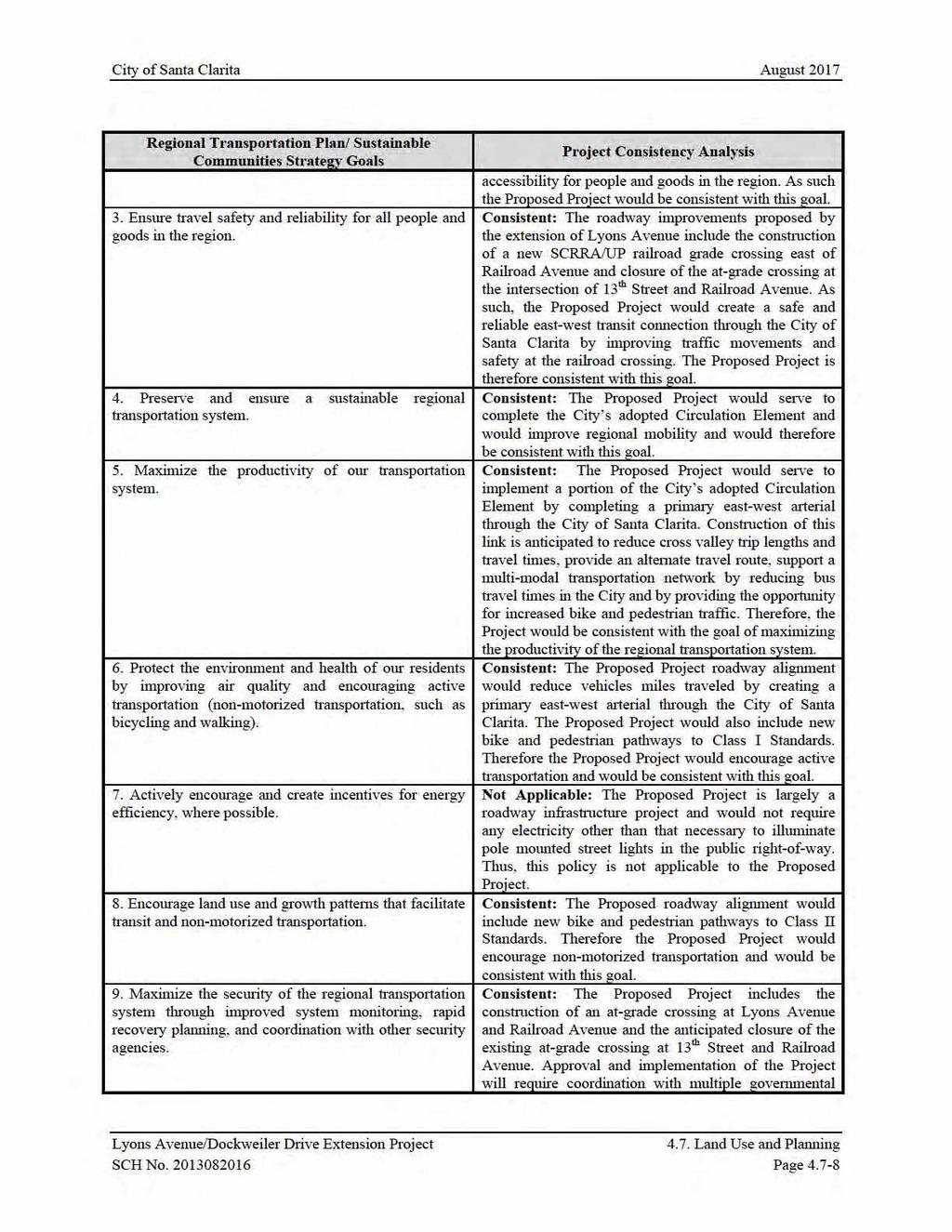
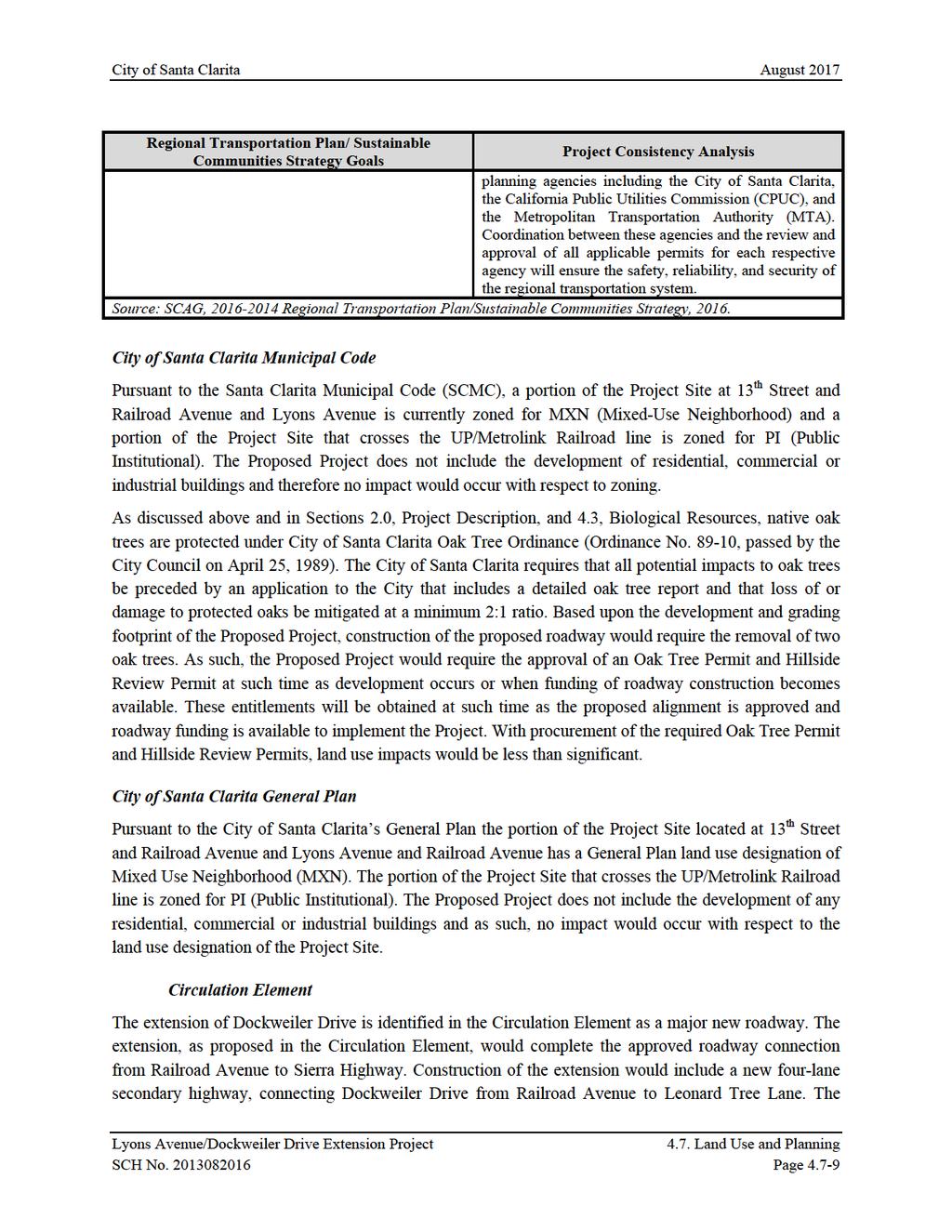
1 4. ENVIRONMENTAL IMPACT ANALYSIS 7. LAND USE AND PLANNING INTRODUCTION The following analysis discusses the consistency of the Proposed Project with the corresponding land use and zoning designations and guidelines within the City of Santa Clarita. The following land use analysis is presented as an informational document to disclose the project s consistency or inconsistency with the existing adopted regional land use plans and local land use and zoning regulations ENVIRONMENTAL SETTING Existing and Adjacent Land Uses The existing Project Site consists of improved segments of Railroad Avenue and Lyons Avenue roadways and undeveloped land to the east extending towards Dockweiler Drive. The west end of the Project Site encompasses portions of Newhall Creek and traverses a storage yard utilized by Los Angeles County Department of Public Works. The portion of the Project Site that includes the intersection of Railroad Avenue and 13 th Street is developed with existing road surface and an at-grade crossing. The UP/Metrolink Railroad line crosses the Project Site east of the intersection of Railroad Avenue and Lyons Avenue Railroad and at the intersection of Railroad Avenue and 13 th Street. The portion of the Project Site to the east of the intersection of Railroad Avenue and Lyons Avenue is bounded by commercial and industrial uses to the north a landscape nursery to the south east, the Jan Heidt Newhall Metro Link Station and open space to the south, and the Old Town Newhall Library and commercial uses to the west across Railroad Avenue. The portion of the Project Site to the east of the intersection of Railroad Avenue and 13 th Street is bounded by undeveloped land to the north, commercial and industrial uses to the east, Newhall Creek to the south, and one-story commercial buildings to the west, across Railroad Avenue. Relevant Land Use Policies The Project Site is subject to the designations and regulations of several local and regional land use and zoning plans. At the regional level, the Project Site is located within the planning area of the Southern California Association of Governments (SCAG), the region s federally-designated metropolitan planning organization, and therefore is subject to SCAG s Regional Comprehensive Plan and Guide (RCPG) and the 2016 Regional Transportation Plan/Sustainable Communities Strategy (RTP/SCS). The Project is also located within the South Coast Air Basin (SCAB) and therefore is within the jurisdiction of the South Coast Air Quality Management District (SCAQMD) and is subject to SCAQMD s Air Quality Management Plan (AQMP). The Project Site is located within the Los Angeles Watershed Basin and is subject to the regulatory oversight of the Los Angeles Regional Water Quality Control Board (LARWQCB). In addition, the Project Site is subject to the Congestion Management Plan (CMP) for Los Angeles County. Lyons Avenue/Dockweiler Drive Extension Project 4.7. Land Use and Planning SCH No Page 4.7-1
2 City of Santa Clarita August 2017 At the local level, development of the Project Site is guided by the General Plan of the City of Santa Clarita (General Plan). The General Plan provides general guidance on land use issues and planning policy for the entire City. The Circulation Element of the General Plan is applicable to the Proposed Project, as it promotes a variety of techniques for improving mobility within the City of Santa Clarita. The City of Santa Clarita Municipal Code (SCMC) guides zoning, land use decisions and development patterns for individual properties. Within the City of Santa Clarita, the Project Site is located in the Placerita Canyon Special Standards District (PCSSD) and is part of the North Newhall Area (NNA), which includes a Mixed-Use Overlay Zone. In addition, the Project Site is located in the City s Compass Blueprint Concept Plan (Concept Plan) area, and is adjacent to the Old Town Newhall Specific Plan (Specific Plan) area. Southern California Association of Governments SCAG is a federally designated Metropolitan Planning Organization (MPO) representing six counties (Ventura, Orange, San Bernardino, Riverside, Imperial, and Los Angeles). SCAG is mandated by federal and State law to research and draw up plans for transportation, growth management, hazardous waste management, and a regional growth forecast that is the foundation for these plans and regional air quality plans developed by the South Coast Air Quality Management District (SCAQMD). SCAG divides its planning area into 15 subregions. The Project Site is located within the North Los Angeles County subregion. As part of its regional planning efforts, SCAG prepared and has adopted the 2012 Regional Transportation Plan/Sustainable Communities Strategy (RTP/SCS) to address regional growth and measure progress toward achieving regional planning goals and objectives. Regional Transportation Plan/ Sustainable Communities Strategy (RTP/SCS) On April 2016, SCAG s Regional Council adopted the Regional Transportation Plan/Sustainable Communities Strategy (RTP/SCS): A Plan for Mobility, Accessibility, Sustainability, and a High Quality of Life. The RTP/SCS is the culmination of a multi-year effort involving stakeholders from across the SCAG Region. The RTP/SCS balances the Southern California region s future mobility and housing needs with economic, environmental, and public health goals. Based on the regional growth projections in the RTP/SCS, the City of Los Angeles had an estimated permanent population of approximately 3,845,500 persons, approximately 1,325,500 residences, and 1,696,400 jobs. 1 By the year 2040, SCAG forecasts the City of Los Angeles will increase to 4,609,400 persons (or a 20 percent increase from the year 2012) with approximately 1,690,300 residences (or an 28 percent increase from the year 2012) and approximately 2,169,100 jobs (or an 1 Southern California Association of Government, Regional Transportation Plan / Sustainable Communities Strategy, Demographics and Growth Forecast Appendix, adopted April Lyons Avenue/Dockweiler Drive Extension Project 4.7. Land Use and Planning SCH No Page 4.7-2
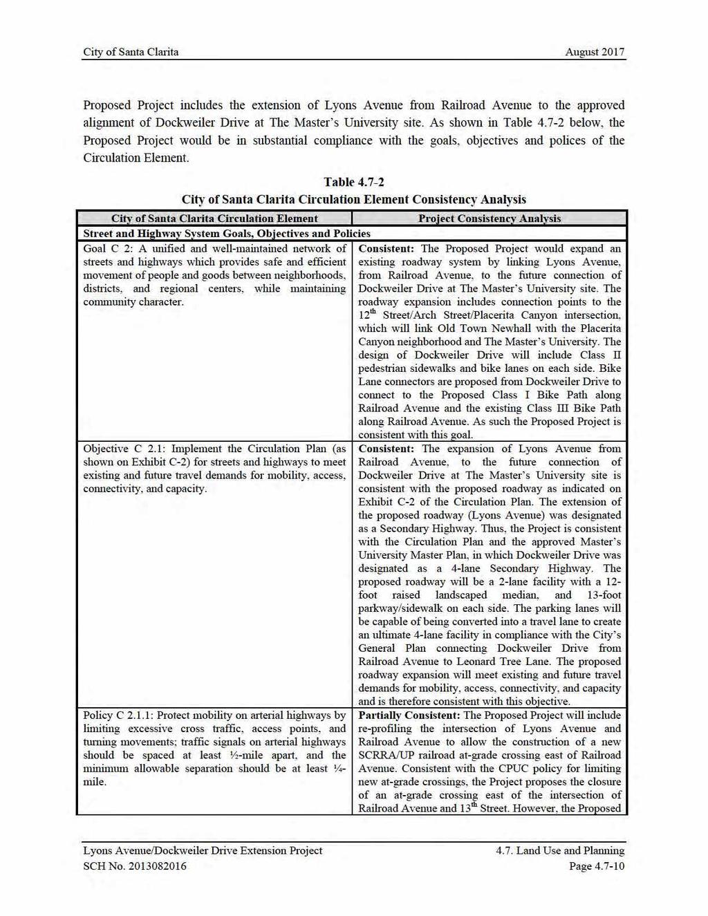
3 City of Santa Clarita August 2017 approximate 28 percent increase from year 2012) 2. The RTP/SCS incorporates SCAG s Compass Growth Vision, adopted in 2004, which encourages better relationships between housing, transportation, and employment. The Growth Vision is driven by four key principles: (1) Mobility Getting where we want to go, (2) Livability Creating positive communities, (3) Prosperity Long-term health for the region, and (4) Sustainability Preserving natural surroundings. Additionally, the Compass Growth Vision incorporates a 2% Growth Strategy that will increase the region s mobility by putting new employment centers and new neighborhoods near major transit systems. Compass Blueprint Concept Plan As part of SCAG's Sustainability Program, the Compass Blueprint program partners SCAG with local governments to develop demonstration projects that promote land use and transportation planning and implement regional visions at the local level. Compass Blueprint is guided by four core principles, which include, mobility, livability, prosperity and sustainability. The City of Santa Clarita s Compass Blueprint Concept Plan is a conceptual land use and circulation plan that guides development in the Newhall community north of Old Town Newhall and east of Railroad Avenue. The Concept Plan consists of a mix of commercial, office and residential uses that serve to strengthen the Old Town Newhall area, encourage the use of public transit, and be compatible with the rural and equestrian character of Placerita Canyon. South Coast Air Quality Management District The Project Site is located within the South Coast Air Basin (SCAB) and is therefore within the jurisdiction of the South Coast Air Quality Management District (SCAQMD). In conjunction with SCAG, the SCAQMD is responsible for formulating and implementing air pollution control strategies. The Air Quality Management Plan (AQMP) is intended to establish a comprehensive regional air pollution control program leading to the attainment of state and federal air quality standards in the SCAB area. Air quality impacts of the Proposed Project and consistency of the Project impacts with the AQMP is analyzed in greater detail in Section 4.2, Air Quality of this Draft EIR. Congestion Management Program The Congestion Management Program (CMP) is a state-mandated program that was enacted by the State Legislature with the passage of Proposition 111 in The program is intended to address the impact of local growth on the regional transportation system. As required by the 2010 Congestion Management Program for Los Angeles County, a Traffic Impact Assessment (TIA) has been prepared to determine the potential impacts on designated monitoring locations on the CMP highway system. The analysis has been prepared in accordance with procedures outlined in the 2010 Congestion Management Program for Los Angeles County, County of Los Angeles 2 Ibid. Lyons Avenue/Dockweiler Drive Extension Project 4.7. Land Use and Planning SCH No Page 4.7-3
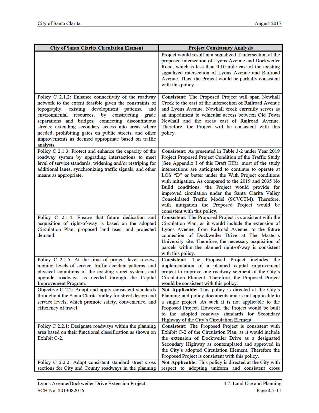
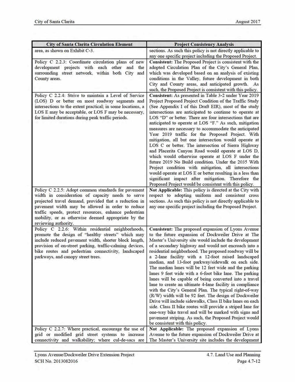
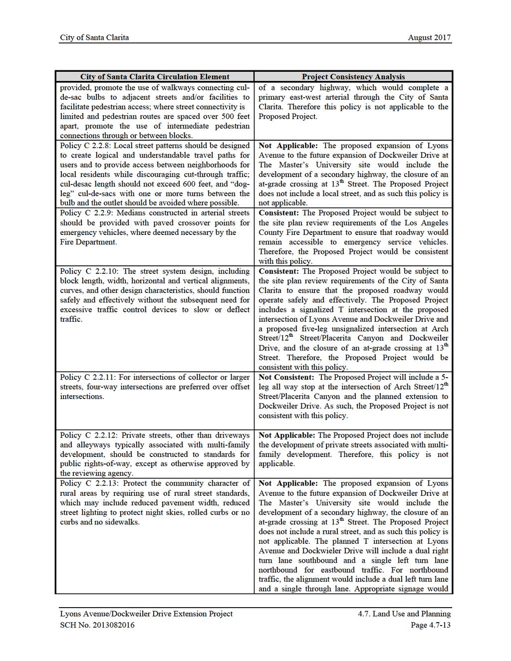
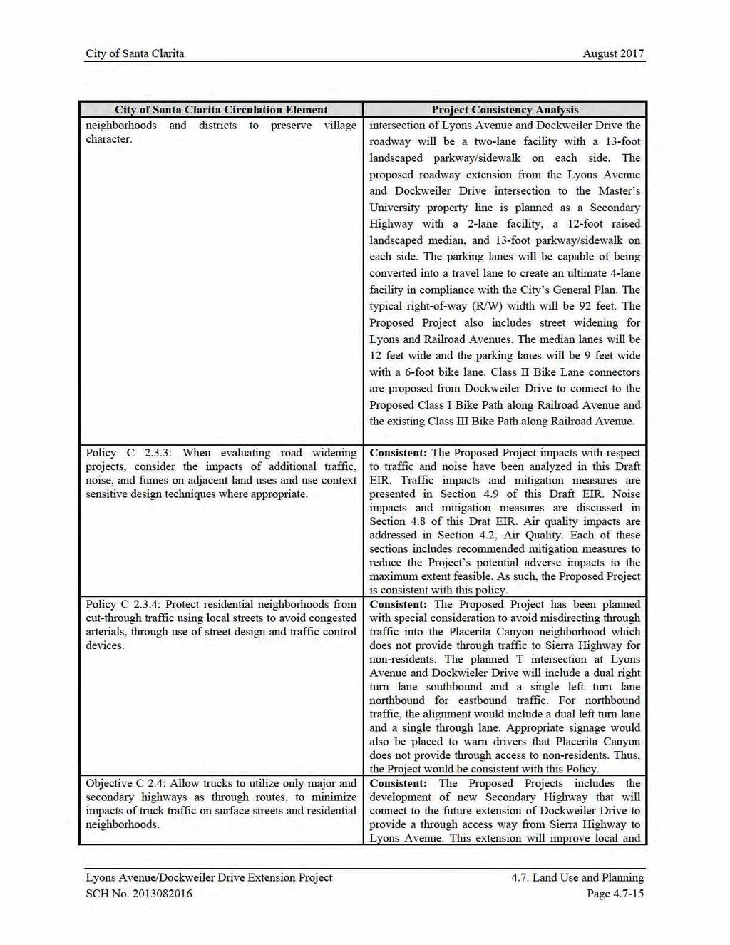
4 City of Santa Clarita August 2017 Metropolitan Transportation Authority. Refer to Section 4.9, Transportation and Traffic, for a complete discussion and project impact analysis related to the CMP. The City of Santa Clarita General Plan Land use decisions are guided by the City of Santa Clarita s General Plan, which establishes goals and policies related to land use, transportation, population growth and distribution, development, open space, resource preservation and utilization, air and water quality, noise impacts, public safety, infrastructure, and other related physical, social, and economic factors. As stated in the General Plan, in addition to serving as a basis for local decision making, the General Plan establishes a clear set of development guidelines for citizens, developers, neighboring jurisdictions and agencies, and provides the community with an opportunity to participate in the planning process. The purpose of this General Plan is to comply with state requirements and to provide the City with a comprehensive, long-range policy guideline for future development. Pursuant to the City of Santa Clarita s General Plan the portion of the Project Site located at 13 th Street and Railroad Avenue and Lyons Avenue and Railroad Avenue has a General Plan land use designation of Mixed Use Neighborhood (MXN). The General Plan states that areas with a MXN designation should be developed to create neighborhoods that combine residential uses with complementary commercial services, including retail and office uses. MXN zoned areas should be located in close proximity to public transit and provide roadway and trail linkages to adjacent development. Circulation Element The Circulation Element of the General Plan aims to guide the development of efficient, cost-effective and comprehensive transportation systems that are consistent with regional plans and local needs of the City of Santa Clarita. Planning for the location and capacity of circulation improvements serves to enhance economic strength and quality of life in Santa Clarita. The Santa Clarita Valley s circulation system provides vital connections linking neighborhoods, services, and employment centers throughout the community and the region. A comprehensive transportation network of roadways, multi-use trails and bike paths, bus transit, and commuter rail provides mobility options to Santa Clarita residents and businesses. The Circulation Element identifies and promotes a variety of techniques for improving mobility, which includes: development of alternative travel modes and support facilities; increased efficiency and capacity of existing systems through management strategies; and coordination of land use planning with transportation planning by promoting concentrated, mixed-use development near transit facilities. The extension of Dockweiler Drive is identified in the Circulation Element as a major new roadway. The proposed roadway from the Arch Street/12 th Street/ Placerita Canyon/Dockweiler Drive intersection to the future intersection of Lyons Avenue and Dockweiler Drive will be a two-lane facility with a 13- foot landscaped parkway/sidewalk on each side. The proposed roadway from the Lyons Avenue and Dockweiler Drive intersection to the Master s University property line will be a 2-lane facility with a 12- Lyons Avenue/Dockweiler Drive Extension Project 4.7. Land Use and Planning SCH No Page 4.7-4
5 City of Santa Clarita August 2017 foot raised landscaped median, and 13-foot parkway/sidewalk on each side. The median lanes will be 12 feet wide and the parking lanes 9 feet wide with a 6-foot bike lane. The parking lanes will be capable of being converted into a travel lane to create an ultimate 4-lane facility in compliance with the City s General Plan. The typical right-of-way (R/W) width will be 92 feet. Santa Clarita Municipal Code All development activity on the Project Site is subject to the Santa Clarita Municipal Code (SCMC), particularly Chapter I7, Zoning. The Planning and Zoning Code establishes requirements for the Project Site, with respect to permitted uses, building height, density, yard setbacks, and parking. The portion of the Project Site located at 13 th Street and Railroad Avenue and Lyons Avenue and Railroad Avenue is currently zoned for MXN (Mixed-Use Neighborhood). Pursuant to SCMC Chapter 17.35, Section 020, the residential density range in mixed-use neighborhoods designates a minimum of 6 to a maximum of 18 dwelling units per acre, and maximum floor area ratio (FAR) for the nonresidential portion of the development is 0.5. The maximum building height of a project is 50 feet. The portion of the Project Site that crosses the UP/Metrolink Railroad line is zoned for PI (Public Institutional). The PI zoning designation identifies lands that are used for various types of public or/and community serving facilities owned and operated by public agencies, special districts, nonprofit organizations and other entities. Allowable uses include civic and governmental offices, public works yards, public or private schools, libraries, day care centers, airports, hospitals and supporting medical facilities, museums, fire stations, police stations, landfills, and prisons. Oak Trees Native oak trees are protected under City of Santa Clarita Oak Tree Ordinance (Ordinance No , passed by the City Council on April 25, 1989) and the City s Oak Tree Preservation and Protection Guidelines (adopted September 11, 1990). The City of Santa Clarita s Oak Tree Preservation ordinance (Unified Development Code ) requires the preservation of all healthy oak trees and that removal, cutting, pruning, relocation, damage, or encroachment into the protected zone of any oak trees measuring 6 inches or larger in circumference (DBH, diameter at breast height) on public or private property can only be done in accordance with a valid oak tree permit issued by the City. Placerita Canyon Special Standards District Chapter 17.39, Section 020, of the SCMC establishes the PCSSD design standards in order to protect, preserve and enhance the secluded, rural and equestrian character of the Placerita Canyon community. The PCSSD ensures that development is compatible with the characteristics of surrounding single-family residential neighborhoods and that development does not negatively impact light, air, and privacy of the existing single-family residences. The PCSSD serves to help mitigate the cumulative impacts of development and ensure reasonable access to public riding and hiking trails. Lyons Avenue/Dockweiler Drive Extension Project 4.7. Land Use and Planning SCH No Page 4.7-5
6 City of Santa Clarita August 2017 North Newhall Area The North Newhall Area (NNA) was established to stimulate development and redevelopment activities in the area north of Old Town Newhall. Most of the NNA is located within the PCSSD. The northern portion of the NNA is undeveloped with a hillside to the north, oak trees and Placerita Creek. The commercial corridor along the west side of Railroad Avenue consists of mixed retail and commercial uses. The SCMC establishes guidelines for the NNA to ensure that it provides buffering, transitional densities and protection for the existing developed areas and not intrude in or change the character of Placerita Canyon located east of the NNA. Additionally, a Mixed Use Overlay Zone was adopted to encourage a mix of residential, commercial, employment, and institutional uses along the Newhall Avenue and Lyons Avenue corridors. The Mixed Use Overlay Zone serves to revitalize older commercial corridors, increase opportunities for infill housing, and encourage development that creates pedestrianoriented neighborhoods. Old Town Newhall Specific Plan As shown in Figure 2-6, of the Project Description, portions of the Project Site are located in the Old Town Newhall Specific Plan area. The Specific Plan encourages mixed-use and transit-oriented development in the historic community of Newhall, in order to promote new investment, spur economic development, and create new residential opportunities in this area. The Specific Plan transformed San Fernando Road into a pedestrian-oriented 'Main Street' with public buildings, parking garages, an open-air market and mixed commercial and residential development ENVIRONMENTAL IMPACTS Thresholds of Significance In accordance with Appendix G of the State CEQA Guidelines, a project may have a significant environmental impact if it were to: (a) Physically divide an established community; (b) Conflict with any applicable land use plan, policy, or regulation of an agency with jurisdiction over the project (including, but not limited to the general plan, specific plan, coastal program, or zoning ordinance) adopted for the purpose of avoiding or mitigating an environmental effect; or (c) Conflict with any applicable habitat conservation plan or natural community conservation plan. Project Impacts The Proposed Project would not physically divide an established community. Rather, the extension of Dockweiler Drive is proposed by the Circulation Element to be one of the primary east-west arterials through the City of Santa Clarita that would provide a through connection from Sierra Highway to Lyons Avenue/Dockweiler Drive Extension Project 4.7. Land Use and Planning SCH No Page 4.7-6
7
8
9
10
11
12
13
14
15
16
17
18
19
20
21
22
23 City of Santa Clarita August 2017 Additionally, Newhall Creek, which extends through the Project Site and provides passage through developed areas between the Santa Clarita River and the Angeles National Forest to the southeast and is considered a part of a wildlife movement or migration corridor. To limit impacts to wildlife movement, four 25-foot wide and 8-foot deep openings in a concrete box bridge with 80-foot wide soft base and 2:1 protected side slopes is proposed where the proposed roadway extension crosses Newhall Creek. As designed, this bridge would not result in any barrier to wildlife movement and would serve to protect Newhall Creek as a functioning wildlife movement corridor. The project as proposed would not result in significant impacts to wildlife movement. Therefore, with incorporation of Mitigation Measure and the aforementioned project design features, impacts with respect to conservation plans would be less than significant CUMULATIVE IMPACTS Cumulative land use impacts could occur if other related projects in the vicinity of the proposed project site would result in land use incompatibility impacts in conjunction with the impacts of the proposed project. However, development of each related project would be subject to all adopted plans and regulations. Based upon the information available regarding the project growth as forecasted in the City s General Plan, it is reasonable to assume that the related projects under consideration in the surrounding community would implement and conform to local and regional planning goals and policies. Therefore, development of the Proposed Project would not result in a significant cumulative land use impact MITIGATION MEASURES No mitigation measures are required LEVEL OF SIGNIFICANCE AFTER MITIGATION The Proposed Project would result in less than significant impacts associated with land use and planning. Lyons Avenue/Dockweiler Drive Extension Project 4.7. Land Use and Planning SCH No Page
2.0 PROJECT DESCRIPTION
 2.0 PROJECT DESCRIPTION 2.1 PROJECT LOCATION The Project Site is located in the City of Santa Clarita, California, about 35 miles north of Downtown Los Angeles. The Project Site is more specifically located
A. LAND USE 1. LAND USE PLANS/ZONES
 IV. ENVIRONMENTAL IMPACT ANALYSIS A. LAND USE 1. LAND USE PLANS/ZONES This Section describes the consistency of the Project with adopted planning and zoning regulations applicable to the Project Site and
III. GENERAL DESCRIPTION OF ENVIRONMENTAL SETTING
 III. GENERAL DESCRIPTION OF ENVIRONMENTAL SETTING Section 15125 of the California Environmental Quality Act (CEQA) Guidelines requires that an EIR include a description of the existing environment. This
SECTION 4.8 LAND USE DRAFT ENVIRONMENTAL IMPACT REPORT DEEP VALLEY DRIVE AND INDIAN PEAK ROAD MIXED-USE RESIDENTIAL PROJECT
 LSA ASSOCIATES, INC. J UNE 2012 SECTION 4.8 LAND USE 4.8 LAND USE Introduction Comprising 10.4 acres (ac), the proposed project site is located in the City of Rolling Hills Estates (City) between Deep
IV. ENVIRONMENTAL IMPACT ANALYSIS H. LAND USE AND PLANNING
 IV. ENVIRONMENTAL IMPACT ANALYSIS H. LAND USE AND PLANNING ENVIRONMENTAL SETTING The Project Site is located in Los Angeles County, within the Hollywood Community Plan area of the City of Los Angeles.
Planning & Zoning Commission Staff Report
 Planning & Zoning Commission Staff Report Meeting Date: May 26, 2015 Drafted by: Katherine Harrison-Rogers CASE # Z2886 PROJECT NAME: APPLICANT/ REPRESENTATIVE: Shawna Runyan PROPERTY OWNER: 1840 (previously
5.9 LAND USE Existing Conditions Historic Land Use Trends Existing Land Use Distribution
 5.9 LAND USE This section describes the existing land use pattern and land use planning/regulatory framework in the City of Fontana. It also evaluates potential long-term land use impacts such as physically
Plano Tomorrow Vision and Policies
 Plano Tomorrow Vision and Policies PLANO TOMORROW PILLARS The Built Environment The Social Environment The Natural Environment The Economic Environment Land Use and Urban Design Transportation Housing
3. VISION AND GOALS. Vision Statement. Goals, Objectives and Policies
 Vision Statement Queen Creek s interconnected network of parks, trails, open spaces and recreation opportunities provide safe and diverse activities and programs that sustain its unique, small town, equestrian
3.0 PROJECT DESCRIPTION
 3.0 PROJECT DESCRIPTION 3.1 BACKGROUND Under California law (Government Code Section 65300 et seq.), every city and county is required to have a general plan. The general plan is to be comprehensive and
IV. ENVIRONMENTAL IMPACT ANALYSIS I. LAND USE PLANNING
 IV. ENVIRONMENTAL IMPACT ANALYSIS I. LAND USE PLANNING ENVIRONMENTAL SETTING Existing Onsite Land Uses The 3.8-acre project site is located at 2055 Avenue of the Stars in the West Los Angeles community
CHAPTER 1. Ms. Guajardo s Class - Central Elementary CH 1 1
 INTRODUCTION CHAPTER 1 Ms. Guajardo s Class - Central Elementary CH 1 1 1.1 SETTING South Centre City is a linear corridor south of Downtown Escondido paralleling Centre City Parkway and South Escondido
Regional Context Statement
 Regional Context Statement REGIONAL CONTEXT STATEMENT 3. REGIONAL CONTEXT STATEMENT In 1995, the Provincial Government passed into law the Growth Strategies Act. The purpose of this provincial initiative
REVIEW AND EVALUATION OF REGIONAL LAND USE
 REVIEW AND EVALUATION OF REGIONAL LAND USE AND TRANSPORTATION SCENARIOS #220831 Environmental Justice Task Force October 7, 2014 VISION 2050 Process Development of Guiding Vision for Land Use and Transportation
CHAPTER 7: VISION AND ACTION STATEMENTS. Noble 2025 Vision Statement
 CHAPTER 7: VISION AND ACTION STATEMENTS This chapter presents the vision, policy and action statements that transform the comprehensive planning study, an analysis of Noble s past, future trends and community
CHAPTER 7: Transportation, Mobility and Circulation
 AGLE AREA COMMUNITY Plan CHAPTER 7 CHAPTER 7: Transportation, Mobility and Circulation Transportation, Mobility and Circulation The purpose of the Transportation, Mobility and Circulation Chapter is to
IV. ENVIRONMENTAL IMPACT ANALYSIS H. LAND USE PLANNING
 IV. ENVIRONMENTAL IMPACT ANALYSIS H. LAND USE PLANNING PREVIOUS ENVIRONMENTAL ANALYSIS Under the Hollywood Redevelopment Plan Amendment, the CRA and the City Council re-established the CRA s ability to
Venice Pumping Plant Dual Force Main Project Draft EIR
 City of Los Angeles 5.9 LAND USE PLANS 5.9.1 Environmental Setting Venice Pumping Plant Dual Force Main Project Draft EIR The Project lies within the bounds of Los Angeles County and the City of Los Angeles.
Ridgefield and the Growth Management Act
 1 2 Ridgefield and the Growth Management Act 3 Why Do We Plan History of Planning in Ridgefield Washington experiences rapid growth in the late 1980 s that began to change the perceived quality of life.
3.10 LAND USE SETTING PROJECT SITE EXISTING LAND USE DESIGNATIONS AND ZONING. General Plan Land Use Designations.
 This section of the Draft EIR addresses the existing land uses on and adjacent to the project site and discusses the potential impacts of the proposed project on existing land uses. Key issues addressed
3.6 LAND USE EXISTING CONDITIONS. Development Site and Surrounding Land Uses
 3.6 Land Use 3.6 LAND USE This section addresses the impacts of the Proposed Project on existing and planned land uses in the Project vicinity. The following analysis considers the Project s compatibility
Section Regulatory Framework/Methodology. Land Use and Development
 Section 4.2 Land Use and Development This section summarizes the existing land uses and developments in the project area, and the potential impacts of the proposed alternatives on these resources. Information
IV. ENVIRONMENTAL IMPACT ANALYSIS D. LAND USE AND PLANNING
 IV. ENVIRONMENTAL IMPACT ANALYSIS D. LAND USE AND PLANNING INTRODUCTION This section of the (Draft EIR) addresses the subject of land use with respect to the proposed Lifeguard Headquarters and Public
1.0 INTRODUCTION 1.1 TH 14 WEST STUDY AREA Project Description Functional Classification Purpose of the Project
 1.0 INTRODUCTION 1.1 TH 14 WEST STUDY AREA 1.1.1 Project Description The Trunk Highway (TH) 14 West Corridor is a two-lane roadway approximately 22 miles in length. Located in Nicollet County, the corridor
Gold Line Bus Rapid Transit Transit Oriented Development (BRTOD) Helmo Station Area Plan
 Helmo Station Area Plan") Appendix F Gold Line Bus Rapid Transit Transit Oriented Development (BRTOD) Helmo Station Area Plan Introduction and Purpose of the Plan The Gold Line Bus Rapid Transit facility is an eleven-mile dedicated
Appendix F Gold Line Bus Rapid Transit Transit Oriented Development (BRTOD) Helmo Station Area Plan Introduction and Purpose of the Plan The Gold Line Bus Rapid Transit facility is an eleven-mile dedicated
The transportation system in a community is an
 7 TRANSPORTATION The transportation system in a community is an important factor contributing to the quality of life of the residents. Without a sound transportation system to bring both goods and patrons
SAN RAFAEL GENERAL PLAN 2040 INTRODUCTION AND OVERVIEW
 SAN RAFAEL GENERAL PLAN 2040 INTRODUCTION AND OVERVIEW Steering Committee Presentation February 14, 2018 Purpose of General Plan Guide land use and development decisions Coordinate transportation, infrastructure,
IV. ENVIRONMENTAL IMPACT ANALYSIS I. LAND USE AND PLANNING
 IV. ENVIRONMENTAL IMPACT ANALYSIS I. LAND USE AND PLANNING ENVIRONMENTAL SETTING The Project Site is located on an irregularly shaped 58 gross square acre property currently occupied by the Verdugo Hills
6. Consistency with Local Plans
 6. Consistency with Local Plans 6.1. Chapter Overview 6.1.1. Introduction This section presents the goals, objectives and policies of municipal, county and state planning entities, as well as known development/redevelopment
Prepared for the Citizens of Forsyth County by the City-County Planning Board
 Prepared for the Citizens of Forsyth County by the City-County Planning Board Bryce A. Stuart Municipal Building 100 East First Street, Winston-Salem, NC 27101 336.727.8000 www.cityofws.org/planning www.legacy2030.com
Implementation Guide Comprehensive Plan City of Allen
 Implementation Guide 2030 Comprehensive Plan City of Allen DRAFT 2015 Implementation Guide Allen 2030 Comprehensive Plan INTRODUCTION The Comprehensive Plan serves as a guide for the growth and development
Introduction and Overview
 Introduction and Overview Articulate local values and priorities Guide land use and development decisions Coordinate transportation, infrastructure, and City services with expected growth and available
IV. ENVIRONMENTAL IMPACT ANALYSIS
 IV. ENVIRONMENTAL IMPACT ANALYSIS IV. ENVIRONMENTAL IMPACT ANALYSIS A. LAND USE AND PLANNING 1. INTRODUCTION This section addresses the impacts of the proposed Project in relationship to applicable land
Transportation. Strategies for Action
 Transportation A major priority for the Overlake Neighborhood is to develop a multimodal transportation system. To achieve this system, a balance has to be found among travel, circulation and access needs;
EXECUTIVE SUMMARY. Introduction
 EXECUTIVE SUMMARY Introduction State Route 68 is a designated scenic route that connects the world-renowned Monterey Peninsula to US Highway 101 and the Salinas Valley. SR 68 is a key route for bicycle,
3.5 - Land Use and Planning
 City of Irvine - William Lyon Homes: Vista Verde Land Use and Planning 3.5 - Land Use and Planning 3.5.1 - Introduction This section describes existing land uses, applicable land use plans, policies or
IV. ENVIRONMENTAL IMPACT ANALYSIS G. LAND USE
 IV. ENVIRONMENTAL IMPACT ANALYSIS G. LAND USE 1. INTRODUCTION This section provides an analysis of the consistency of the proposed project with land use regulations that guide development of the project
HAZARD MITIGATION GOALS AND OBJECTIVES
 SEWRPC Community Assistance Planning Report No. 282, 2nd Edition CITY OF MILWAUKEE ALL HAZARDS MITIGATION PLAN UPDATE Chapter IV HAZARD MITIGATION GOALS AND OBJECTIVES [NOTE: Throughout this plan update
TRANSPORTATION AND LAND USE
 CHAPTER 10 TRANSPORTATION AND LAND USE Transportation and land use are intimately linked. The expansion of a highway typically spurs housing, employment growth and land development in the communities that
Secrest Short Cut and Monroe Expressway Small Area Plan AUGUST 29, 2018
 Secrest Short Cut and Monroe Expressway Small Area Plan AUGUST 29, 2018 Background and Process Monroe Expressway will be open by the end of 2018 Union County and Indian Trail identified a need to revisit
Ten Mile Creek Planning Area
 PLANNING AREA POLICIES TEN MILE CREEK Ten Mile Creek Planning Area Location and Context The Ten Mile Creek Planning Area ( Ten Mile Creek area ) is located south of the current Boise AOCI, generally south
THE 355/270 CORRIDOR:
 THE 355/270 CORRIDOR: Strategic Ideas for Sustaining a Livable Work Place Project Summary ACCESS LIFE DESIGN HEALTH WORK Montgomery County Planning Department The Maryland-National Capital Park and Planning
2040 LUP is a part of the Comprehensive Plan and carries the same legal authority. Economic Challenges
 1.1. Guiding Anchorage s Growth Where will new residents settle over the next two decades? Where will people work, shop, and play? Will there be enough room to grow? How will Anchorage look? Will growth
City of Monrovia Land Use Element. M o n r o v i a G e n e r a l P l a n
 Adopted 01/15/2008 Updated 4/2015 City of Monrovia Land Use Element M o n r o v i a G e n e r a l P l a n Contents CONTENTS 1 INTRODUCTION TO THE LAND USE ELEMENT 2 PURPOSE OF THE LAND USE ELEMENT 2 RELATED
Hockessin Community Redevelopment Plan
 Hockessin Community Redevelopment Plan 3.1 Introduction The Community Redevelopment Plan for the Village of Hockessin is the result of the people s vision for a distinct village center that serves as the
Description of Preferred Alternative
 Chapter 2 Description of Preferred Alternative 2.1 Introduction This chapter of the programmatic Sammamish Town Center Sub-area Plan Final EIS provides a more detailed description of the Preferred Alternative
Corridor Vision. 1Pursue Minnehaha-Hiawatha Community Works Project. Mission of Hennepin County Community Works Program
 1Pursue Minnehaha-Hiawatha Community Works Project Minnehaha-Hiawatha Community Works is a project within the Hennepin Community Works (HCW) program. The mission of the HCW program is to enhance how the
4.1 LAND USE AND PLANNING EXISTING CONDITIONS REGULATORY BACKGROUND LAND USES IN THE PLAN AREA SURROUNDING LAND USES
 4.1 LAND USE AND PLANNING This section includes a description of the existing land use plans that apply to the Plan area and a description of existing land uses in the vicinity. It also includes an analysis
TREASURE COAST REGIONAL PLANNING COUNCIL M E M O R A N D U M. To: Council Members AGENDA ITEM 5H
 TREASURE COAST REGIONAL PLANNING COUNCIL M E M O R A N D U M To: Council Members AGENDA ITEM 5H From: Date: Subject: Staff October 17, 2008 Council Meeting Local Government Comprehensive Plan Review Draft
NEIGHBORHOOD DESIGN ELEMENT
 NEIGHBORHOOD DESIGN ELEMENT INTRODUCTION The following recommendations constitute an urban design oriented "neighborhood analysis" of Plantation. It is an optional Comprehensive Plan Element. The five
4.1.3 LAND USE CATEGORIES
 4.1.3 LAND USE CATEGORIES a. City Center District The City Center District incorporates the existing character and mix of uses in downtown Belmont to encourage redevelopment and new development in keeping
Corridors. Re-vitalize our Corridors and Gateways
 Corridors Re-vitalize our Corridors and Gateways Artist s rendering from the 287 Strategic Plan, 2015 Corridors are the major throughways of Loveland but they also provide important commercial, community
A. WHAT IS A GENERAL PLAN?
 I. Introduction A. WHAT IS A GENERAL PLAN? A general plan is the planning guideline for the future of a city. It contains goals and policies which regulate urban development, the protection of the natural
Joint Public Hearing. Preliminary Subregion 5 Master Plan and Proposed Sectional Map Amendment
 Preliminary Subregion 5 Master Plan and Proposed Sectional Map Amendment Joint Public Hearing April 11, 2013 Council Hearing Room Upper Marlboro 7:00 pm His Lordship s Kindness (Clinton) Presentation Overview
Scope of Services. River Oaks Boulevard (SH 183) Corridor Master Plan
 Corridor Master Plan") Scope of Services River Oaks Boulevard (SH 183) Corridor Master Plan PROJECT AREA The project area consists of the River Oaks Boulevard (SH 183) corridor bounded by SH 199 at the northern end and the Trinity
Scope of Services River Oaks Boulevard (SH 183) Corridor Master Plan PROJECT AREA The project area consists of the River Oaks Boulevard (SH 183) corridor bounded by SH 199 at the northern end and the Trinity
5.1 LAND USE AND RELEVANT PLANNING
 5.1 LAND USE AND RELEVANT PLANNING The purpose of this section is to identify the existing land use conditions, evaluate consistency with relevant planning policies and recommend mitigation measures, which
4. ENVIRONMENTAL IMPACT ANALYSIS 8. LAND USE AND PLANNING
 4. ENVIRONMENTAL IMPACT ANALYSIS 8. LAND USE AND PLANNING 1. INTRODUCTION The following section provides an analysis of the Project s physical compatibility with existing land uses in the vicinity of the
Mark-up of the effect of the proposed Bronte Village Growth Area OPA No.18 on the text of section 24, Bronte Village, of the Livable Oakville Plan
 Mark-up of the effect of the proposed Bronte Village Growth Area OPA No.18 on the text of section 24, Bronte Village, of the Livable Oakville Plan Notes: This document is provided for information purposes
Draft Memorandum #1: Goals and Vision for Revitalization
 Keizer Revitalization Plan Draft Memorandum #1: Goals and Vision for Revitalization Submitted to: City of Keizer April 12, 2018 (revised) Prepared By: Angelo Planning Group and Otak, Inc. Project No. 17482.A
RESOLUTION NO. R Refining the route, profile and stations for the Downtown Redmond Link Extension
 RESOLUTION NO. R2018-32 Refining the route, profile and stations for the Downtown Redmond Link Extension MEETING: DATE: TYPE OF ACTION: STAFF CONTACT: Capital Committee Board PROPOSED ACTION 09/13/2018
4.8 LAND USE AND PLANNING
 4.8 LAND USE AND PLANNING 4.8.1 INTRODUCTION This section describes existing and planned land uses at the Hayward campus and analyzes the impact of implementation of the proposed Master Plan on land uses
Chapter 4. Linking Land Use with Transportation. Chapter 4
 Chapter 4 Linking Land Use with Transportation Chapter 4 59 Chapter 4 Linking Land Use with Transportation Community Design and Transportation Program Introduction Since the 1950s, the predominant development
Status Report: MD 355 Project
 Status Report: MD 355 Project OCTOBER 2006 M-NCPPC MONTGOMERY COUNTY PLANNING DEPARTMENT Summary of Community Comments, and break to the Results of the MD 355 Participation Session Brookside Gardens -
No comments related to land use and planning issues were received in response to the Notice of Preparation.
 4.8 LAND USE AND PLANNING This section analyzes the impacts relative to land use and planning that would occur as a result of implementation of the proposed Facilities Master Plan (proposed project). This
DEVELOPMENT FRAMEWORK 2030 LAND USE PLAN INTRODUCTION
 INTRODUCTION The Oak Grove Land Use Plan anticipates two stages of community development. The first stage of development (28-23) promotes very low density rural growth patterns characterized by large lots,
IV. ENVIRONMENTAL IMPACT ANALYSIS H. LAND USE PLANNING
 IV. ENVIRONMENTAL IMPACT ANALYSIS H. LAND USE PLANNING ENVIRONMENTAL SETTING Existing Land Uses The Project Site is located within the Hollywood Community Planning Area (CPA) of the City of Los Angeles.
SOUTHEAST AREA SPECIFIC PLAN. Planning Commission Study Session August 18, 2016
 SOUTHEAST AREA SPECIFIC PLAN Planning Commission Study Session August 18, 2016 Background: How did we get here? Directed by City Council to prepare Specific Plan (2012) Sustainability focused grant from
CHAPTER 10-D GREATER MONTEREY PENINSULA AREA PLAN
 CHAPTER 10-D GREATER MONTEREY PENINSULA AREA PLAN GREATER MONTEREY PENINSULA AREA PLAN SUPPLEMENTAL POLICIES 1.0 - Land Use GMP-1.1 GMP-1.2 GMP-1.3 GMP-1.4 GMP-1.5 GMP-1.6 GMP-1.7 The County shall overlay
REGIONAL ACTIVITY CENTER
 DRAFT REGIONAL ACTIVITY CENTER 70 EAST BENCH MASTER PLAN DRAFT 06 Introduction The East Bench Regional Activity center is comprised of large educational, research, medical, and employment centers. These
1.0 Introduction. Purpose and Basis for Updating the TMP. Introduction 1
 1.0 Introduction The Town of Castle Rock is situated between the metropolitan areas of Denver and Colorado Springs, amidst a unique terrain of rolling hills, mesas, ravines, and waterways. Like many Front
CHAPTER 12 IMPLEMENTATION
 CHAPTER 12 IMPLEMENTATION The 2010 Town of Denton Comprehensive Plan is intended to capture a vision of the future of Denton. As such, it provides a basis for a wide variety of public and private actions
Final Land Use and Development Opportunities Report 5.0 Environmental Impact/Environmental Consequences
 Figure 5-11. Wilshire/16th 1/4-Mile Station Area August 16, 2010 Page 5-27 Figure 5-12. Wilshire/4th 1/4-Mile Station Area August 16, 2010 Page 5-28 5.7 Alternative 4 Westwood/VA Hospital Extension Plus
1.0 Circulation Element
 5/9/18 1.0 Circulation Element 1.1 Introduction As growth and development occur in Apache County, enhancements to its circulation system will be necessary. With time, more roads will be paved and air and
CITY COUNCIL AGENDA REPORT
 CITY COUNCIL AGENDA REPORT Subject: COUNCIL MOTION LRT ALIGNMENT REMOVAL FROM THE TRANSPORTATION MASTER PLAN On February 10, 2016 Councillor Hughes provided notice in accordance with Section 23 of Procedure
Sacramento Area Council of Governments (SACOG)
") Sacramento Area Council of Governments (SACOG) The Blueprint Vision The SACOG Board of Directors adopted the Preferred Blueprint Scenario in December 2004, a bold vision for growth that promotes compact,
Sacramento Area Council of Governments (SACOG) The Blueprint Vision The SACOG Board of Directors adopted the Preferred Blueprint Scenario in December 2004, a bold vision for growth that promotes compact,
Municipal Development Plan Update Urban Service Area and Hamlets
 ENCLOSURE 1 Municipal Development Plan Update Urban Service Area and Hamlets Priorities Committee January 24, 2017 MUNICIPAL DEVELOPMENT PLAN UPDATE SHAPING OUR FUTURE MDP Update - Agenda MDP Update Public
Lyons Avenue/Dockweiler Drive Extension Project Final Environmental Impact Report
 Lyons Avenue/Dockweiler Drive Extension Project Final Environmental Impact Report Lead Agency: City of Santa Clarita 23920 Valencia Blvd., Ste. 302 Santa Clarita, CA 91355 Contact: Carla Callahan, Senior
Planning Commission Staff Report June 5, 2008
 Owner/Applicant Taylor Village Sacramento Investments Partners, LP c/o Kim Whitney 1792 Tribute Road #270 Sacramento, CA 95815 Staff Recommendation Planning Commission Staff Report Project: File: Request:
SECTION UNIFIED DEVELOPMENT ORDINANCE SECTION Part 1 Ordinance. ARTICLE 1 Zoning Districts
 SECTION 1-100 UNIFIED DEVELOPMENT ORDINANCE SECTION 1-300 Part 1 Ordinance SECTION 1-100. Introduction. ARTICLE 1 Zoning Districts Crystal Lake strives to maintain a balance of various land uses for a
ARTICLE XXXIII (O) OJUS URBAN AREA DISTRICT
 OJUS URBAN AREA DISTRICT") Page 1 ARTICLE XXXIII (O) OJUS URBAN AREA DISTRICT Sec. 33-284.99.14 Purpose, intent and applicability. A. The regulations contained in this chapter and Chapter 18A, Landscape Code, Code of Miami-Dade
Page 1 ARTICLE XXXIII (O) OJUS URBAN AREA DISTRICT Sec. 33-284.99.14 Purpose, intent and applicability. A. The regulations contained in this chapter and Chapter 18A, Landscape Code, Code of Miami-Dade
Appendix G Response to Comments
 Appendix G Response to Comments This appendix contains the comments received during the public circulation and comment period (May 27, 2008 to July 11, 2008). The comments have been numbered (Comment Set
LAND USE ELEMENT. Purpose. General Goals & Policies
 LAND USE ELEMENT Purpose This Land Use Element contains the goals and policies necessary to support the City s responsibility for managing land resources and guiding development through implementing regulations,
Planning Charlotte s Future. Transportation & Planning Committee March 14, 2016
 Planning Charlotte s Future Transportation & Planning Committee March 14, 2016 Charlotte s Vision Livable city Vibrant economy Thriving natural environment Diverse population Choices for housing, education,
Concord Community Reuse Project Goals and Guiding Principles. Overarching Goals (OG)
") Concord Community Reuse Project Goals and Guiding Principles Overarching Goals (OG) No priority is implied by the order of presentation of the goals and guiding principles. Overarching goals for the Concord
Concord Community Reuse Project Goals and Guiding Principles Overarching Goals (OG) No priority is implied by the order of presentation of the goals and guiding principles. Overarching goals for the Concord
Definitions. Average Daily Traffic Demand (ADT): The actual number or projected number of cars that pass a point in a 24-hour period.
: The actual number or projected number of cars that pass a point in a 24-hour period.") Definitions Access Management: A combination of physical techniques and transportation policies used to control the flow of traffic between roads and the surrounding lands. Alternative City Form Scenarios:
Definitions Access Management: A combination of physical techniques and transportation policies used to control the flow of traffic between roads and the surrounding lands. Alternative City Form Scenarios:
Chapter 1.0 Introduction
 Chapter 1.0 Introduction 1.1 Background The North Metro commuter rail line is part of the RTD FasTracks regional transit system expansion program to build more than 100 miles of rail transit throughout
ARROYO PROJECTS ADOPTED CAPITAL IMPROVEMENT PROGRAM BUDGET
 A RROYO P ROJECTS ADOPTED CAPITAL IMPROVEMENT PROGRAM BUDGET FISCAL YEARS 214-218 HAHAMONGNA Priority Description 1 Hahamongna Watershed Park - Implement Master Plan 211,6 211,6 (77565) 2 Hahamongna -
4. Environmental Setting
 4.1 INTRODUCTION The purpose of this section is to provide, pursuant to provisions of the California Environmental Quality Act (CEQA) and the State CEQA Guidelines, a description of the physical environmental
Eastern Terminus TECHNICAL MEMORANDUM CENTRAL BROWARD EAST-WEST TRANSIT ANALYSIS BROWARD COUNTY, FLORIDA
 Eastern Terminus TECHNICAL MEMORANDUM CENTRAL BROWARD EAST-WEST TRANSIT ANALYSIS BROWARD COUNTY, FLORIDA FINANCIAL PROJECT ID NUMBER 411189-2-22-01 FLORIDA DEPARTMENT OF TRANSPORTATION DISTRICT 4 Prepared
NEW CASTLE COUNTY S ZONING DISTRICTS
 NEW CASTLE COUNTY S ZONING DISTRICTS This is general information about New Castle County s zoning districts. The information included is by no means exhaustive or complete. Before designing plans to develop
DEVELOPMENT FRAMEWORK POST 2030 LAND USE PLAN INTRODUCTION
 INTRODUCTION Oak Grove s Comprehensive Plan identifies a future Metropolitan Urban Service Area (MUSA). The Metropolitan Council does not anticipate extending utilities to this area prior to 2030. The
4 LAND USE DESIGNATIONS
 4 LAND USE DESIGNATIONS Chapter 4 describes the land use designations and densities that will implement the development vision for North Burlingame outlined in Chapter 3. Land use densities are described
TRANSPORTATION ELEMENT GOALS, OBJECTIVES, AND POLICIES
 TRANSPORTATION ELEMENT GOALS, OBJECTIVES, AND POLICIES GOAL 2 The City shall provide a safe, convenient, effective, and energy efficient multimodal transportation system which is coordinated with the Future
EXECUTIVE SUMMARY DRAFT CHAPTER 1 INTRODUCTION EXECUTIVE SUMMARY
 CHAPTER 1 EXECUTIVE SUMMARY INTRODUCTION Through the joint efforts of the City of Tulsa planning staff and the Land Services division of Indian Nations Council of Governments (INCOG), the Berryhill Land
Section 9 NEIGHBORHOOD DESIGN
 Section 9 NEIGHBORHOOD DESIGN City of Lancaster Comprehensive Plan D u n k i n, S e f k o & A s s o c i a t e s, I n c. NEIGHBORHOOD DESIGN INTRODUCTION There are many ways in which a neighborhood can
Northwest Rail Corridor and US 36 BRT Development Oriented Transit Analysis 4.4 STATION AREA FINDINGS
 4.4 STATION AREA FINDINGS Each station is different, and each one requires a separate set of recommendations based on the vision for the site. This section outlines an initial TOD strategy and recommendations
GUIDELINES WESTON LOCATION: URBAN DESIGN GUIDELINES
 Development in the Weston area will be consistent with the following urban design guidelines. The guidelines correspond to Site and Area Specific Policies 45, 46, 47, 48, 49, 51, 52 and 232 in Chapter
Planning Districts INTRODUCTION
 INTRODUCTION To facilitate detailed examination of development prospects for all areas of the community, Delano has been divided into 14 planning districts. The location of these planning districts is
ADOPTED CAPITAL IMPROVEMENT PROGRAM BUDGET ARROYO PROJECTS
 ADOPTED CAPITAL IMPROVEMENT PROGRAM BUDGET ARROYO PROJECTS HAHAMONGNA FY 212-216 Capital Improvement Program Priority Description Total Estimated Costs Appropriated Through FY 211 Adopted FY 212 FY 213
CITY OF CLAREMONT MASTER PLAN 2017 CHAPTER 1: LAND USE
 CITY OF CLAREMONT MASTER PLAN CHAPTER 1: LAND USE Prepared by the Claremont Planning Board and the Claremont Planning and Development Department Vision Claremont Master Plan Chapter 1: Land Use Claremont