TOURISM FACILITIES AND ACCOMMODATION
|
|
|
- Marcia Baldwin
- 5 years ago
- Views:
Transcription

1 DRAFT SUPPLEMENTARY PLANNING GUIDANCE CONSULTATION DOCUMENT TOURISM FACILITIES AND ACCOMMODATION MAY 2018 ANGLESEY AND GWYNEDD JOINT LOCAL DEVELOPMENT PLAN
2 Contents 1.0 Introduction and Purpose of the Supplementary Planning Guidance Purpose Introduction Planning Policy Context National Planning Policy Joint Local Development Plan Tourism Overarching Planning Considerations High Quality Development Landscape/Environmental Considerations Welsh Language Considerations Permanent Serviced and Self-Serviced Holiday Accommodation Type of units Scale of development Converting existing buildings Suitable previously developed land Extensions to existing permanent holiday accommodation development business Existing supply / Over-concentration of permanent self-catering holiday developments Applications to delete the Occupancy Condition Static Caravan, Chalets and Permanent Alternative Camping Accommodation Type of Units Standalone developments Significant intensification Coastal Change Management Areas Using static caravans and chalets for residential purposes Touring Caravan, Camping and Temporary Alternative Camping Accommodation Type of Units Landscape considerations Highway considerations Periods of Operation Ancillary facilities Excessive use of hard standings and man-made features Occupancy Conditions Visitor Attractions and Facilities Location of Development Further Information & Contacts Appendix 1 Relevant JLDP Policies STRATEGIC POLICY PS 1: WELSH LANGUAGE AND CULTURE STRATEGIC POLICY PS 5: SUSTAINABLE DEVELOPMENT POLICY PCYFF 2: DEVELOPMENT CRITERIA
3 POLICY PCYFF 3: DESIGN AND PLACE SHAPING POLICY PCYFF 4: DESIGN AND LANDSCAPING POLICY ARNA 1: COASTAL CHANGE MANAGEMENT AREA POLICY TWR 1: VISITOR ATTRACTIONS AND FACILITIES POLICY TWR 2: HOLIDAY ACCOMMODATION POLICY TWR 3: STATIC CARAVAN AND CHALET SITES AND PERMANENT ALTERNATIVE CAMPING ACCOMMODATION POLICY TWR 4: HOLIDAY OCCUPANCY POLICY TAI 14: RESIDENTIAL USE OF CARAVANS POLICY TWR 5: TOURING CARAVAN, CAMPING AND TEMPORARY ALTERNATIVE CAMPING ACCOMMODATION Appendix 2 LANDMAP Collector File Example Appendix 3 Sensitivity and Capacity Maps Appendix 4 - Business Plan Template Appendix 5 Coastal Change Management Areas
4 1.0 Introduction and Purpose of the Supplementary Planning Guidance 1.1 Purpose The Purpose of this Guidance is to: assist the public and their agents in preparing planning applications and in guiding them in discussions with officers before submitting planning applications, assist officers to assess planning applications, and officers and councillors to make decisions about planning applications, and help Planning Inspectors make decisions on appeals The general aim is to improve the quality of new developments and facilitate a consistent and transparent way of making decisions. The Policy Context Local Development Plan Under planning legislation, the planning policies for every area are contained within the 'development plan'. The Gwynedd and Anglesey Joint Local Development Plan was adopted on 31 July It relates to the Gwynedd and Anglesey Planning Authority area The Plan provides wide-ranging policies along with allocations for the main land uses, such as housing, employment and retail; it will help shape the future of the Plan area physically and environmentally, and will also influence it economically, socially and culturally. The Plan, therefore, attempts to: guide the Local Planning Authorities to make rational and consistent decisions on planning applications by providing a policy framework that is consistent with national policy; and guide developments to suitable areas during the period up to The need for Supplementary Planning Guidance Although the Plan contains policies that enable the Local Planning Authority to make consistent and transparent decisions on development applications, it cannot provide all the detailed advice required by officers and prospective applicants to steer proposals locally. In order to provide this detailed advice, the Councils are preparing a range of Supplementary Planning Guidances to support the Plan that will provide more detailed guidances on a variety of topics and matters to help interpret and implement the Plan's policies and proposals. The Status of Supplementary Planning Guidance Supplementary Planning Guidance (SPG) may be considered to be material planning considerations during the process of assessing and determining planning applications. Welsh Government and the Planning Inspectorate will place considerable weight on supplementary planning guidance that stem from, and are consistent with, a development plan. The SPGs do not introduce any new planning policies In accordance with Welsh Government advice, the SPG has been the subject of a public consultation and a resolution to adopt by the Joint Planning Policy Committee on behalf of the Councils. A draft version of this SPG was approved for public 4
5 consultation on date by Committee name. The supplementary planning guidance was the subject of a public consultation exercise between date. The x observations presented to the Councils were considered and, where appropriate, appropriate changes have been included in the final draft approved by the Joint Planning Policy Committee on date to be used as a material consideration when assessing and determining planning applications and appeals. A summary of the observations and the Councils' response are given in Appendix or location of a Committee report. (Once it has been adopted) This document should, therefore, be given substantial weight as a material planning consideration. 1.2 Introduction This SPG covers all forms and scales of holiday accommodation and tourism attractions. Tourism is a dynamic sector and is subject to continuous change. It plays a significant role in the plan area s economy. The visitor economy provides jobs, services and facilities that are essential to the well-being and enjoyment of local communities and residents in the plan area. The importance of tourism can be seen in the table 1 below: 2016 Gwynedd* Anglesey Total economic impact of tourism 1.01 billion million Total visitor numbers (millions) Number of staying visitors (millions) Number of day visitors (millions) Number of FTE 2 jobs supported by 15,557 4,032 tourism spend *includes Snowdonia National Park Both Anglesey and Gwynedd benefit form extensive natural and cultural assets that offer considerable potential for residents and visitors to enjoy. However new tourism developments can have a negative impact upon the local environment and communities if they are insensitively developed or inappropriately located Both Gwynedd Council and the Isle of Anglesey County Council are committed to the principles of sustainability and the Joint Local Development Plan has sustainable development at its core and recognises that all development in the plan area should embody these principles, balancing the need to support the rural economy, whilst maintaining and enhancing the environmental, social and cultural quality of the plan area. See policy PS 5 Sustainable Development in Appendix 1. 1 STEAM Report FTE = Full Time Employment 5
6 2.0 Planning Policy Context 2.1 National Planning Policy National planning policy guidance on tourism is set out in Chapter 11 of Planning Policy Wales (PPW, Edition 9, Nov 2016) and reflects the Welsh Government s aim to encourage tourism to grow in a sustainable way and make an increasing contribution to the economic, social and environmental well-being in Wales (11.1.2). It states that the planning system should encourage sustainable tourism in ways which enable it to contribute to economic development, conservation, rural diversification, urban regeneration and social inclusion, recognising the needs of visitors and those of local communities (11.1.4) It recognises that in rural areas, tourism-related development is an essential element in providing for a healthy and diverse economy. New tourism developments should be sympathetic in nature and scale to the local environment, local communities and visitors (11.1.7). It also recognises that there is a need to limit new development to avoid damage to the environment (for example in undeveloped coastal areas) (11.1.6) Further guidance is also contained in the Technical Advice Notes (TAN) TAN13: Tourism (1997) which provides advice on hotel development, static and touring caravans and seasonal occupancy conditions. TAN6: Planning for Sustainable Communities (2010) contains advice such as the location of development and the conversion of buildings for holiday use. 2.2 Joint Local Development Plan The Anglesey and Gwynedd Joint Local Development Plan (JLDP) was adopted on the 31 st July 2017 and provides the planning policy framework for this SPG. The important role of tourism in the plan area is reflected in the JLDP which seeks to support and enable sustainable tourism development while at the same time ensuring that the natural and built environment are preserved and enhanced The overarching strategic policy for tourism in the JLDP is policy PS14: The Visitor Economy as set out below: STRATEGIC POLICY PS14: THE VISITOR ECONOMY Whilst ensuring compatibility with the local economy and communities and ensuring the protection of the natural, built and historic environment the Councils will support the development of a year-round local tourism industry by: 1. Focusing larger scale, active and sustainable tourism, cultural, the arts and leisure development in the sub-regional centre, urban service centres, and, where appropriate, local service centres; 2. Protecting and enhancing existing serviced accommodation and supporting the provision of new high quality serviced accommodation in the sub-regional, urban and local service centres and villages; 3. Managing and enhancing the provision of high quality un-serviced tourism accommodation in the form of self-catering cottages and apartments, camping, alternative luxury camping, static or touring caravan or chalet parks; 4. Supporting appropriately scaled new tourist provision and initiatives in sustainable locations in the countryside through the reuse of existing buildings, where appropriate, or as part of farm diversification, particularly where these would also benefit local communities and support the local economy and where they are in accordance with sustainable development objectives; 6
7 5. Preventing development that would have an unacceptable adverse impact on tourist facilities, including accommodation and areas of visitor interest or their setting, and maximise opportunities to restore previous landscape damage This SPG contains the following information: Section 3 Overarching Planning Considerations Section 4 Permanent Serviced and Self Serviced Accommodation Section 5 Static Caravan, Chalet and Permanent Alternative Camping Accommodation Sites Section 6 Touring Caravans, Camping and Temporary Alternative Camping Accommodation Sites Section 7 Holiday Occupancy Section 8 Visitor Attractions and Facilities 7
8 3.0 Tourism Overarching Planning Considerations There are a number of considerations that are relevant to the majority of proposals for new or extensions to tourism facilities and holiday accommodation which are set out below. Other considerations may, however, be relevant to the different types of proposals being put forward. These issues will be considered in later sections of this SPG. 3.1 High Quality Development (Policy TWR 1 criterion ii; Policy TWR 2; Policy TWR 3 criterion 1; Policy TWR 5 criterion 1) This refers to the quality of the development in terms of land-use considerations and not to any recognised grading scheme operated by the tourism industry. In addition to local policy requirements, national policy guidance states that development in rural areas should embody sustainability principles, balancing the need to support the rural economy, whilst maintaining and enhancing the environmental, social and cultural quality of rural areas (TAN13: Transport, para 3.11) All proposed tourism developments should be high quality in terms of design, layout and appearance. A primary consideration will be the overall quality of the scheme, measured against the requirements of the plan s development management policies (see Appendix 1): Policy PCYFF2: Development Criteria, which states that development proposals should not have an adverse impact on the health, safety or amenity of the local community due to increased activity, disturbance, vibration, noise, dust, fumes, litter, drainage, light pollution, or other forms of pollution or nuisance. Policy PCYFF3: Design and Place Shaping, which states that all proposals will be expected to demonstrate high quality design which fully takes into account the natural, historic and built environment context and contributes to the creation of attractive, sustainable places, and, Policy PCYFF4: Design and Landscaping, which states that all proposals should integrate into their surroundings. Proposals that fail to show (in the manner appropriate to the nature, scale and location of the proposed development) how landscaping had been considered from the outset as part of the design proposal will be refused Central to deciding the land use effects of applications are the criteria which help to define a high quality development. No policy document can be prescriptive, or exhaustive, in describing the opportunities that may arise. In terms of the planning of high quality development the issues will normally relate to the type of factors identified below. (Please note this is not an exhaustive list and each application will be assessed on its merit). Criteria which help define high quality development in terms of land use considerations include: Sites located in a sustainable location i.e. within or close to existing settlements where new development can be best be accommodated in terms of infrastructure, access and habitat and landscape conservation and sites not normally lying in open countryside unless there is robust justification for this; 8
9 Sites that are close to the main highway network and have good links to various modes of transport; Sites that are not visually intrusive on the landscape, are well screened and do not cause adverse harm to protected landscapes (e.g. the AONB and SLAs); Sites that are of a suitable scale to fit in with their surroundings; Sites that have existing landscape cover and no major visual impact; Protecting the undeveloped coast; Protecting and promoting biodiversity interest; Respect for the historic and natural environment; Helps reinforce and strengthen an existing tourism centre and makes better use of land by consolidating areas of existing tourism activity (tourist attractions, marina etc.); Enhancing suitable previously developed (brown field) land; Part of as scheme for agricultural diversification and supporting the rural economy. 3.2 Landscape/Environmental Considerations (Policy TWR 3 criterion 1; Policy TWR 5 criterion 1) Landscape setting, site layout and screening are important considerations in assessing tourism proposals. The JLDP policies state that new developments should be located in an unobtrusive location. An unobtrusive location is defined in the plan as one which is well screened by existing landscape features and/or where units can be readily assimilated into the landscape without the need for excessive man made features Policy PCYFF4: Design and Landscaping states that all proposals should integrate into their surroundings. Proposals that fail to show (in a manner appropriate to the nature, scale and location of the proposed development) how landscaping has been considered from the outset as part of the design proposal will be refused. The policy gives guidance on the contents of a landscape scheme, and should, where relevant: 1. Demonstrate how the proposed development has given due consideration to the Landscape Character Area Assessment or Seascape Character Area Assessment; 2. Demonstrate how the proposed development respects the natural contours of the landscape; 3. Demonstrate how the proposed development respects and protects local and strategic views; 4. Respect, retain and complement any existing positive natural features, landscapes, or other features on site; 5. Identify trees, hedgerows, water courses and topographical features to be retained; 6. Provide justification for circumstances where the removal/loss of existing trees, hedgerows, water courses and topographical features cannot be avoided and provides details of replacements; 7. Provide details of any proposed new landscaping together with a phased programme of planting; 8. Demonstrate that any proposed new planting includes plants and trees of mainly native species of local provenance and does not include any non-native invasive species; 9
10 9. Ensure that selection of species and planting position of any trees allows for them to grow to their mature height without detriment to nearby buildings, services and other planting; and 10. Provide permeable hard surface landscaping Where appropriate, visuals, landscape visual impact assessment, where appropriate, and photomontages from viewpoints agreed with the LPA to demonstrate potential visual impacts of a proposed development should be provided along with mitigation measures to address the identified impacts The landscaping scheme should be submitted with the application. Conditions will be used to ensure that the agreed landscaping scheme is implemented before the development becomes operational and is maintained in perpetuity There will be unsuitable sites in an open countryside location i.e. where there are no exiting natural screening or when the development is in a prominent location, where no amount of landscaping will mitigate any impacts Applicants will be expected to demonstrate how they have considered the information provided by the Gwynedd Landscape Strategy 3, Anglesey Landscape Strategy 4, Landscape Sensitivity and Capacity Study 5 and the LANDMAP resource 6. LANDMAP is an all-wales landscape resource where landscape characteristics, qualities and influences on the landscape are recorded and evaluated. It contains detailed surveys for individual areas called Collector Files. An example of a collector file can be found in Appendix Within the AONBs and SLAs all developments must have regard for the AONB and SLA special qualities. Applications that have a significant impact on these special qualities will be refused. 3.3 Welsh Language Considerations (Policy PS 1; Policy PS 5 criterion 4) The Welsh language plays an important role in the social, cultural and economic life of the Plan area s residents and visitors. Where development is proposed, consideration must be given to the enhancement and protection of the language and culture. Strategic Policy PS1 sets out the context for the assessment of the potential impact of proposals upon the language and culture (see Appendix 1) In terms of tourism development the larger proposals that involve employing more than 50 people and/or with and area of 1,000sq metres will require a Welsh Language Statement, which will protect, promote and enhance the Welsh language. All
11 proposals, irrespective of type, size or location, will be expected to comply with criterion 4 and 5 of PS1 which is the requirement of a bilingual signage scheme to deal with all operational signage in the public domain that are proposed in a planning application by public bodies and by commercial and business companies. It is expected that existing Welsh names are retained and appropriate Welsh names are used for new developments Criteria 3 of PS1 states that the Councils will refuse proposals which would cause significant harm to the character and language balance of a community that cannot be avoided or suitably mitigated by appropriate planning mechanisms Further information on the above can be found in the Maintenance and creation of distinctive and sustainable communities SPG. 11
12 4.0 Permanent Serviced and Self-Serviced Holiday Accommodation Policy TWR 2: Holiday Accommodation (see Appendix 1) provides the primary policy framework for the provision of new or the extension of existing permanent serviced and self-serviced holiday accommodation facilities. The main policy considerations are as follows: Type of Units Scale of development Converting existing buildings Suitable previously developed land Extensions to existing permanent holiday accommodation development Over-concentration of permanent self-catering holiday accommodation Planning Conditions 4.1 Type of units The type of units considered under this policy are permanent buildings that are constructed on site over a period of time, unable to be dismantled and rebuilt elsewhere. 4.2 Scale of development Criteria ii. of TWR 2 states that all proposed developments should be appropriate in scale having regard to the site, location and/or settlement in question. To ensure that this is achieved a thorough assessment of the character of both the site and its surrounds and the site s existing or potential relationships with any important focal points, views, historic buildings etc. needs to be undertaken by the applicant. In line with national planning policy it is expected that large scale new developments will be located within to existing settlements or on suitable previously developed land, which already have the infrastructure to service the development, and protect the open countryside from inappropriate development. Factors that will be taken into account when assessing the scale of a proposal include: 1. That the site is of sufficient size to accommodate the proposal without prejudicing any appropriate provision of ancillary facilities such as soft landscaping and parking and service areas. (See policy PCYFF 4, Appendix 1). 2. That the scale of the development is compatible with, and fits comfortably into its surrounding (See policy PCYFF 3, Appendix 1). 3. In accord with the principles of promoting sustainable development it is important that new developments (including those on previously developed sites), which could substantially increase the number of journeys made by private vehicles, should be located within or as close as possible to, or within reasonable walking distance of the service centres identified in the Plan s settlement hierarchy, and/or within reasonable safe walking distance to public transport interchanges or routes. 4. That the scale of the development does not adversely impact on the cultural character of the local community but is proportionate to the size and character of existing buildings/business and any settlement it is located within or nearby. 4.3 Converting existing buildings When assessing planning applications for the re-use or adaption of a building to either serviced or self-serviced holiday accommodation facilities, the primary consideration will be whether the nature and extent of the new use proposed for the building is 12
13 acceptable in planning terms. Further information can be found in the Conversion of Buildings in the Open Countryside SPG The following is a list of issues that will be considered in order to assess the building s suitability to be used specifically as holiday accommodation: i. The building is structurally sound and capable of conversion without major or complete reconstruction, large extensions or major alterations; ii. The building is suitable for the specific use; iii. Any inherit characteristics of merit in the building are retained and any features of historical or architectural importance are safeguarded; iv. The conversion does not result in unacceptable impacts upon the structure, form, character or setting where the building is of historic and / or architectural interest; v. Protecting biodiversity interests such as bats; vi. The conversion respects the character, scale and setting of the existing building; vii. Their form, bulk and general design are in keeping with their surroundings; viii. The conversion does not lead to dispersal of activity on such scale as to prejudice town and village vitality; ix. The need for new services to the property; x. Whilst it should not normally be necessary to consider whether a building is no longer needed for its present purposes, it will be appropriate to investigate (a) the history of the building to establish whether it was ever used for the purpose for which it was claimed to have been built, and/or (b) the impact of its loss on any adjoining/nearby properties (e.g. loss of any curtilage buildings); xi. The proposed use s compatibility with existing adjoining/ nearby property s use in terms of noise, traffic disturbance, lack of privacy for any adjoining property/ nearby property; xii. The existing building s effect on the landscape in terms of visual amenity and whether the proposal would secure an improvement in the external appearance of the building. xiii. The proposal would not harm the amenities of neighbouring properties Any application to convert an existing building must be accompanied by a full structural survey by a qualified person which demonstrates that the building is structurally capable of conversion without extensive rebuilding, alterations and extensions. The structural survey must relate to the proposed plans i.e. that the building can take the works proposed, and should include trail pits so that fundamental issues are known e.g. what foundations exist, is underpinning required etc Further guidance can be found in national planning policy guidance. Paragraph of TAN 23: Economic Development 7 states that the re-use and adaptation of existing rural buildings has an important role in meeting the needs of rural areas for commercial and industrial development, and tourism, sport and recreation. In recognising this, local planning authorities are expected to adopt a positive approach to the conversion of rural buildings for business re-use, especially those buildings located within or adjoining farm building complexes. 4.4 Suitable previously developed land
14 4.4.1 In the case of proposals for new visitor attractions and serviced and self-serviced holiday accommodation, all development proposals will have to be either located within a development boundary or on suitable previously developed land. The JLDP uses the definition of previously developed land found in Planning Policy Wales (9 th Edition, Nov 2016: Figure 4.4) which states: Previously developed land is that which is or was occupied by a permanent structure (excluding agricultural or forestry buildings) and associated fixed surface infrastructure. The curtilage (see note 1 below) of the development is included, as are defence buildings, and land used for mineral extraction and waste disposal (see note 2 below) where provision for restoration has not been made through development management procedures. Excluded from the definition are: land and buildings currently in use for agricultural or forestry purposes; land in built-up areas which has not been developed previously, for example parks, recreation grounds and allotments, even though these areas may contain certain urban features such as paths, pavilions and other buildings; land where the remains of any structure or activity have blended into the landscape over time so that they can reasonably be considered part of the natural surroundings; previously developed land the nature conservation value of which could outweigh the re-use of the site; and previously developed land subsequently put to an amenity use. Notes: 1. The curtilage is defined as the area of land attached to a building. All of the land within the curtilage of the site will also be defined as previously-developed. However this does not mean that the whole area of the curtilage should therefore be redeveloped. For example, where the footprint of a building only occupies a proportion of a site of which the remainder is open land (such as a hospital) the whole site should not normally be developed to the boundary of the curtilage. The local planning authority should make a judgement about site layout in this context, bearing in mind other planning considerations such as policies for the protection of open space, playing fields or development in the countryside. They should consider such factors as how the site relates to the surrounding area and requirements for on-site open space, buffer strips and landscaped areas. 2. This relates to minerals and waste sites which would otherwise remain unrestored after use because the planning permission allowing them did not include a restoration condition. All other such sites will be restored to greenfield status, by virtue of the planning condition Once established that the development is located on previously developed land (as defined in the box above) an assessment of its suitability must be undertaken. Factors that define the suitability of the previously developed land include: Location As the plan promotes sustainable development, proposals involving development on poorly sited development will not be considered to align with the Policy s approach. In line with national planning policy it is expected that new development will be located within or close to existing settlements which already have the infrastructure to service the development and which are accessible via sustainable means of transport. 14
15 Nature of the previously developed land Urban development (nature of and appearance) in the open countryside can often be considered as alien to its natural surroundings therefore careful consideration should be given to the visual/landscape impact of such development, i.e. new buildings located above a ridgeline or which occupy a top of slope/ridge location or would otherwise be a prominent feature in the landscape will be unacceptable. It should be ensured that any proposed development will not have a tangible greater impact on the character and openness of the surrounding area in comparison to that of the previously developed land All applications for demolishion and rebuilding of an existing building must be accompanied by a structural survey in order to assess the structural condition of the existing building to ascertain whether it is capable of conversion or not. It is not the policy s intention to allow for the demolition of an existing structurally sound building in order to engineer new brownfield land. 4.5 Extensions to existing permanent holiday accommodation development business Any application for extensions to existing permanent holiday accommodation developments must prove that there is an established link between the proposed and current development i.e. will form part of the same planning unit, must be part the same business and the application to extend the holiday accommodation business is part of a wider scheme to improve the business and tourist offer in the Plan area The scale and design of the proposed development should be commensurate with the existing business. 4.6 Existing supply / Over-concentration of permanent self-catering holiday developments The number of holiday accommodation units within some communities in the plan area is already significantly high and can have a detrimental impact on the cultural character of those local communities. Criteria v. of policy TWR2 relates to the over-concentration of permanent holiday accommodation In order to support all applications for the development of self-serviced holiday accommodation all applicants will be required to submit a detailed business plan, which demonstrates the robustness of the proposed scheme and to prove compliance with criteria v. of the policy The purpose of the business plan is to enable the Authority to assess whether the scheme has a realistic chance of being viable, is not speculative in nature, and would help to make sure that there is no loophole to allow the redevelopment of existing buildings in the countryside for holiday use, and then allow them to convert to residential use if shown to be unviable in holiday use. The business plan The Business Plan is not expected to be a long and complex document, however detailed information supported by quantitative and qualitative information will be required (as applicable). Further, the level of detail/information expected to be included within the Business Plan needs to be commensurable with the proposal. Evidence 15
16 which support any assumptions within the Business Plan should be included and annexed as appropriate within the Plan The Business Plan should be prepared by a qualified individual/company. For example, those undertaking the Business Plan could be an Architect, Professional Planner, Chartered Surveyor, Financial Advisor or an expert in the field of tourism (or a combination of these individuals) with the applicant s input in terms of the business vision for the future. The Business Plan should clearly state who has undertaken the Plan along with the individual s qualification in relation to undertaking the work All Business Plans will be assessed by the Planning Officer in consultation with competent officers within the Council. Further assistance may be required by external experts at the applicants expense In order to give advice to applicants relating to what information should be included within the Business Plan a template has been included in appendix 4. Please note that the template is not definitive but it does give guidance on the type of information which is required. The template is an adaptation of guidance given by Business Wales [ 4.7 Applications to delete the Occupancy Condition A planning condition will be placed on all applications that the property(ies) will be used for holiday accommodation purposes only. A number of these properties are located in the open countryside, away from the settlements identified in the JLDP, in areas where new residential development would not normally be permitted. If robust evidence is provided to demonstrate that the property is no longer viable as a holiday let, a sequential approach will be taken to manage the property s occupation, in line with national planning policy guidance. In the first instance, the applicant will need to demonstrate sound planning reasons that the property cannot be adapted for another employment use. Then, if it can be proven that no other employment uses can be found for the building then it could suitable for workers who work on a rural enterprise locally and there are no existing dwellings available on the enterprise (subject to planning consent) Finally, if the LPA is satisfied that there are no eligible rural enterprise workers seeking accommodation, the eligibility will be extended to local persons who would be eligible for consideration for affordable housing. In this respect, the views of the Housing Service should be sought regarding the local need for affordable housing For this purpose the occupancy of the property shall be restricted as follows: The holiday unit/s shall be occupied for holiday purposes only and shall not be occupied as a person s sole or main place of residence. The owners / operators of the holiday unit/s shall maintain an up-to-date register, log of the names of all owners / occupiers of the holiday unit/s on the site and of their main home addresses and shall make the information available at all reasonable times, to the Local Planning Authority. If it can be demonstrated that the holiday unit is no longer viable, the following uses will be considered: a) a suitable alternative employment use, or occupied by a person solely or mainly working on a rural enterprise in the locality; where there is/was a defined functional need; or if it can be demonstrated that there is no eligible alternative employment use, to those: 16
17 b) who would be eligible for consideration for affordable housing under the local authority s housing policies; or if it can be demonstrated that there are no persons eligible for occupation under (a); c) widows, widowers or civil partners of the above and any resident dependants The size of the converted or new holiday unit must not be excessive or it may not be affordable if, for some reason, the holiday property is no longer viable. Please note that this is relevant to properties classified as C3 use in the use class order. 17
18 5.0 Static Caravan, Chalets and Permanent Alternative Camping Accommodation Policy TWR 3: Static Caravan, Chalets and Permanent Alternative Camping Accommodation (see Appendix 1) provides the primary policy framework for the provision of new or the extension of existing sites. The main policy considerations are as follows: Type of units Standalone developments Significant intensification Coastal change management areas Using static caravans and chalets for residential purposes 5.1 Type of Units The type of units that are acceptable under this policy are units which are capable of being dismantled an re-assembled elsewhere if required, they include prefabricated units which involve little construction on site. Caravan means any structure designed for human habitation which is capable of being moved from one place to another as defined under the Caravan Sites and Control of Development Act 1960 (and amended by the Caravan Sites Act 1968). Chalet A single storey semi-permanent prefabricated unit which can be dismantled and built elsewhere. Permanent Alternative Camping Accommodation - These are units, because of their degree of permanency, physical attachment to the ground and due to the nature of their design, cannot be entirely removed off site when not in use. 5.2 Standalone developments Applications for standalone single caravans or chalets placed in a field or within the curtilage of residential dwellings without any associated facilities are not considered to be high quality development and therefore do not align with Policy TWR 3. These type of developments do not enhance the type and quality of tourist offer in the plan area and the cumulative effects of such developments can have a negative impact on the landscape. 5.3 Significant intensification Policy TWR 3 stipulates that proposals for new static caravan or chalet developments which lie outside the Areas of Outstanding Natural Beauty (AONB) and Special Landscape Areas (SLAs) will only be permitted provided that the proposal conforms with the criteria listed within the policy. The first criteria states as follows:- i) it can be demonstrated that it doesn t lead to a significant intensification in the provision of static caravan or chalet sites in the locality In order to define intensification within the remit of Policy TWR 3, the explanation to the Policy refers to the Isle of Anglesey, Gwynedd and Snowdonia National Park 18
19 Landscape Sensitivity and Capacity Study (Gillespies, 2014) 8. Within the study each Landscape Character Area (as defined by the Anglesey Landscape Strategy 9 and the Gwynedd Landscape Strategy 10 ) is assessed to determine the landscapes overall capacity for further caravan and chalet park developments. When considering applications for new developments, reference should therefore be made to the capacity of the local landscape as specified within the Landscape Sensitivity and Capacity Study The tables in Appendix 3 specify the various typologies for caravan and chalet park developments along with the overall capacity and sensitivity for each Landscape Character Area. The maps in Appendix 3 shows each Landscape Character Area and their capacity for static caravan and chalet developments. 5.4 Coastal Change Management Areas Shoreline Management Plans (SMP) are developed by Coastal Groups with members mainly from local councils and the Environment Agency (which now forms part of Natural Resources Wales). They identify the most sustainable approach to managing the flood and coastal erosion risks to the coastline in the: short-term (up to 2025) medium term (2026 to 2055) long term (2056 to 2105) The West Wales SMP 2 11 covers the plan area and provides a large-scale assessment of the risks associated with coastal processes during the above epochs and is the primary source of evidence in defining coastal change management areas. It sets a range of polices for the coastline which are: Hold the line No active intervention Managed realignment Planning Policy Wales states that Local Authorities should help reduce the risk of flooding and the impact of coastal erosion by avoiding inappropriate development in vulnerable areas. A Coastal Change Management Area (CChMA) is defined where the accepted shoreline management plan policy is for no active intervention or managed realignment during the Plan period. Appendix 5 provides a schedule of coastal areas defined as the CChMA. The coastal areas included in the CChMA are those where the SMP 2 sets a no active intervention or managed realignment policy approach either up to 2025 or between 2026 and 2055 policy epochs or both policy epochs Policy TWR 3 does not allow for new units in the AONBs and SLAs. Criteria 2 of the policy, however, states that, in exceptional circumstances, proposals involving the relocation of an existing site already located in the AONBs or SLAs and the CChMA to another site outside CChMA provided that the new site is:
20 i. of a high quality in terms of design, layout and appearance, and is sited in an unobtrusive location which is well screened by existing landscape features and/or where the units can be readily assimilated into the landscape in a way which does not significantly harm the visual quality of the landscape; and ii. located close to the main highway network and that adequate access can be provided without significantly harming landscape characteristics and features. Preference will be given to brownfield sites. 5.5 Using static caravans and chalets for residential purposes Caravans and other forms of non-permanent accommodation are generally considered to be unacceptable as permanent homes. However they may have a part to play in providing short term low cost accommodation where there is a proven need. Policy TAI 14: Residential Use of Caravans, Mobile Homes or other forms of Non-Permanent Accommodation provides the local policy framework to deal with such scenarios (see Appendix 1) One of the possible scenarios includes making use of caravans and other forms of non-permanent accommodation as temporary accommodation required in association with an approved building project The following matters need to be considered when assessing a proposal for using caravans, mobile homes or other forms of non-permanent accommodation for temporary residential purposes: 1. Need i. There is a demonstrable need for temporary residential accommodation for a limited period of time and the proposed use of caravans, mobile homes and other forms of non-permanent accommodation forms part of a robust construction worker accommodation strategy; ; 2. Location and accessibility i. The proposed site is not located within an AONB or Special Landscape Area ii. Outside an AONB or Special Landscape Area, the proposal doesn t lead to a significant intensification in the provision of static caravans, chalet or permanent alternative camping sites in the locality iii. The proposed site is located within an agreed traveling distance from the approved building project and set out in the construction worker accommodation strategy. iv. The proposed sites is well related to existing settlements in order to facilitate access to services and facilities such as health and retail. v. The proposed site is located close to the main highway network and is close to public transport interchanges, bus routes and any park and ride vi. parks/pickups in order to reduce dependency on the use of the private car. Adequate access can be provided without significantly harming landscape characteristics and features 3. Type and suitability of the accommodation and site i. The unit must be suitable for year round occupancy in terms of, for example, adequate heating, ventilation and air conditioning ii. iii. The site must be deemed suitable for year round occupancy especially during the winter months where adverse weather could cause problems. The proposed development is of a high quality in terms of design, layout and appearance and is sited in an unobtrusive location, which is well screened by existing landscape features 20
21 5.5.4 For the avoidance of doubt, the use of touring caravans, camping or temporary alternative camping sites for temporary residential use is not promoted by Policy TWR 5 as touring caravan, tents and temporary alternative camping accommodation sites provide pitches for caravans, etc that are on tour, are not open throughout the year and are not deemed suitable for occupation during the winter months. 21
22 6.0 Touring Caravan, Camping and Temporary Alternative Camping Accommodation Policy TWR 5: Touring Caravan, Camping and Temporary Alternative Camping Accommodation (see Appendix 1) provides the primary policy framework for the provision of new or the extension of existing sites. The main policy considerations are as follows: Type of Units Landscape considerations Highway considerations Periods of operation Ancillary facilities Excessive use of hardstanding and man-made features 6.1 Type of Units The type of units covered by this policy include touring caravans, motorhomes, campervans, tents and temporary alternative camping accommodation such as bell tents and tee pees. Typically the holiday accommodation units covered by this policy have infrastructure requirements in the form of amenity blocks as many forms of units do not contain facilities such as toilets, showers and kitchens Temporary alternative camping units have less impacts on the landscape than permanent alternative camping accommodation (please see paragraph 5.1.1) and can be removed when not in use. Applicants will have to demonstrate how the unit will be removed when not in use. 6.2 Landscape considerations Although in use for only part of the year, touring caravan and camping sites are often situated in prominent and open locations and can be very intrusive in the open countryside, particularly on the coast. Particularly heavily pressurised areas exist in many communities located on or near to the coast, including extensive parts of the Areas of Outstanding Natural Beauty. The Authority will require strong evidence that proposals for further units of accommodation in such areas will not add to servicing problems, unacceptable traffic impacts or harm the character or natural resources of these areas National Planning Policy guidance states that the primary objective for designating AONBs is the conservation and enhancement of their natural beauty. Development plan policies and development management decisions affecting AONBs should favour conservation of natural beauty, although it will also be appropriate to have regard to the economic and social well-being of the areas. Local authorities, other public bodies and other relevant authorities have a statutory duty to have regard to AONB purposes (PPW 5.3.5) Both AONBs have a management plan that sets out the characteristics and special qualities of the landscape of the designation and how they will be conserved and enhanced 12. All developments within the AONBs (and areas that contribute to their
23 setting) must have regard for these special qualities (Policy PS 19 and Policy AMG 1). Applications that have a significant impact on these special qualities will be refused (Policy PS 19) As with all applications, the scale of development, landscape setting, site layout and screening are important considerations in assessing proposals. In all cases the applicant will need to submit a landscaping scheme (Policy PCYFF 4). Please see section Highway considerations It is important that new sites are located as close as possible to the main highway network (i.e. A and B class roads). Unclassified rural roads are generally single track lanes and are considered unsuitable for heavy volumes of traffic. Any proposal which in the Authority s opinion is not sited within close proximity to the main highway network will not be supported. Furthermore, these roads are generally bounded by natural/man made features (e.g. stone walls, cloddiau, hedgerows) which are important to the visual character of rural areas. Providing suitable access from new sites onto these roads may require the removal of important landscape features. The importance of such features are identified in the LANDMAP study and the Authority will be guided by the findings of this study. The Authority will expect applicants to demonstrate how they have considered the information provided by the LANDMAP study (see paragraph 6.2.1). 6.4 Periods of Operation New touring, camping and temporary alternative camping sites may be permitted in areas where static caravan, chalets and permanent alternative camping sites are not i.e. AONBs and SLAs, because they can be considered acceptable in land use planning terms as having less impact on the landscape than static sites because, by their very nature, they have transient features which do not impose permanent, year round effects on the local environment. Policy TWR 5 does not promote the development of static touring sites whereby the unit is left permanently on site throughout the whole holiday season and used only occasionally by its owner or other visitors. By allowing the units to stay on site all year round they have the same effect, in terms of land use planning and visual impact, as a new static caravan or chalet site. Criterion 7 of policy TWR 4 clearly stipulates that the site is used for touring purposes only and that any units are removed from site during periods when not in use. Where planning permission is granted for new touring sites a planning condition will be attached to the permission limiting the use of the site for touring purposes only Paragraph states that since the countryside looks very different during the winter months, a condition will be attached to planning permissions for all new sites approved, limiting the operational period of the site to between 1st March and 31st October of the same year. 6.5 Ancillary facilities Amenity blocks (showers, toilets, laundry and kitchen areas) are often required to accompany new touring caravan, camping and temporary alternative camping 23
24 accommodation sites because these facilities are not usually incorporated within the accommodation itself. In such instances, the first preference for these facilities would be for the conversion of suitable existing buildings (as stated in criteria 4 of policy TWR 5. Where this is not possible, the need for new facilities needs to be clearly demonstrated, commensurate with the scale of the development, situated as near as possible to existing buildings, well screened and subject to other relevant policy considerations, including landscape impact. Careful consideration should be given to the scale and design of amenity facilities so that they are proportionate to the scale of the permitted site and to ensure the any harmful landscape and environmental impacts are minimised Ancillary facilities should be shared facilities and not individual facilities per pitch as to minimise the effect on the landscape. 6.6 Excessive use of hard standings and man-made features In order to ensure minimum visual impact upon the landscape, especially during the closed season when there are no units on site, the proposed development should avoid excessive use of hard standings and man-made features. Where possible, measures should be taken to restore the site to its original state when not in use / during the closed season The use of hard standing for every touring units is not considered appropriate as they become a permanent feature on the landscape. Sites that require excessive hard standing because of local site conditions are considered unsuitable The JLDP and national planning policy guidance promotes the use of Sustainable Urban Drainage Systems (SUDS) (policy PS 5; Sustainable Development and policy PCYFF 6: Water Conservation). Policy PCYFF 4 states that permeable surfaces should be used. 24
25 7.0 Occupancy Conditions 7.1 Statistics 13 show that the nature of holidays in the Plan area has become more diverse in location, season and duration in recent years. More people are choosing short breaks outside the traditional summer months. Both national and local planning guidance recognises the importance of having a year round sustainable tourism economy. 7.2 Whilst extending the season has many advantages in terms of supporting the tourist economy and reducing the disadvantages of seasonal staff, the demand for holiday accommodation may occur in areas which the provision of permanent housing would be contrary to national planning guidance. In all cases, the use of such visitor accommodation for permanent occupancy will not be acceptable. Holiday accommodation of all types must remain for the intended tourism purpose only so that the wider economic benefits are secured. Planning conditions will be used to ensure compliance. 7.3 Policy TWR 4 allows for proposals to extend the holiday season provided that: It can be demonstrated that the accommodation is being used exclusively for holiday purposes and does not become the occupant s main residence; The accommodation and site is suitable for occupation during the winter months; The extended season would not increase the consequences of an extreme flooding event; The extended season will not have a detrimental effect on the local environment. 7.4 In order to ensure that the holiday accommodation is being used exclusively for the use intended the owners must keep an up to date register of the names of all owner/occupiers of the units and their main home address and be made available at all reasonable times to the local planning authority. 7.5 A seasonal occupancy condition will be imposed on all proposals which do not comply with the criteria in policy TWR4. Seasonal occupancy conditions will be placed on all new touring caravan, camping and temporary glamping sites. 13 STEAM Report
26 8.0 Visitor Attractions and Facilities Policy TWR 1: Visitor Attractions and Facilities (see Appendix 1) provides the primary policy framework for the provision of new or the extension of existing visitor attractions and facilities. 8.1 Location of Development This policy aims to encourage the development of high quality sustainable tourism attractions and facilities in the right place. New attractions and facilities should be located, where possible, within settlement development boundaries where visitors can access a range of services by a choice of travel modes The policy stipulates that where there are no opportunities are available for development within the development boundary the Authority would consider other locations as follows: i. Re-using a suitable existing building outside development boundaries proposals should first look at re-using existing buildings. More information regarding converting existing buildings can be found in section 5.2 ii. Suitable previously developed land please see section 5.3 iii. A site closely related to other existing buildings that forms part of an existing tourist facility new build developments could be permitted in certain areas of the open countryside if it can be demonstrated there are no sequentially preferable sites within development boundaries or no suitable existing building to re-use. On sites outside existing settlements, the Councils will permit tourism developments only in exceptional circumstances where the applicant has been able to demonstrate specific locational requirements and economic benefits which would justify allowing the proposal. iv. An activity restricted to a specific location due to its appropriate use of an existing historical or natural resource or its proximity to the attraction which it relates the Plan recognises that some new tourism attractions and facilities will have specific locational requirements such as a lake or woodland. The criteria used to assess the its proximity to the attraction it relates includes the degree of separation and physical distance from the attraction. The landscape and visual impact of the proposed development and the ability to integrate the development into the landscape and townscape will also be important considerations in assessing the proposed development s suitability. 26
27 9.0 Further Information & Contacts For further information please contact the: Joint Planning Policy Unit First Floor, Bangor City Council Offices, Ffordd Gwynedd, Bangor Gwynedd LL57 1DT Gwynedd Council s Planning Service, Council Offices Ffordd y Cob Pwllheli Gywnedd LL53 5AA planning@gwynedd.llyw.cymru Isle of Anglesey s Planning Service Council Offices Llangefni Anglesey LL77 7TW planning@anglesey.gov.uk 27
28 Appendix 1 Relevant JLDP Policies 14 STRATEGIC POLICY PS 1: WELSH LANGUAGE AND CULTURE The Councils will promote and support the use of the Welsh language in the Plan area. This will be achieved by: 1. Requiring a Welsh Language Statement, which will protect, promote and enhance the Welsh language, where the proposed development falls within one of the following categories: a. Retail, industrial or commercial development employing more than 50 employees and/or with an area of 1,000 sq. m. or more; or b. Residential development which will individually or cumulatively provide more than the indicative housing provision set out for the settlement in Policies TAI 1 TAI 6; or c. Residential development of 5 or more housing units on allocated or windfall sites within development boundaries that doesn t address evidence of need and demand for housing recorded in a Housing Market Assessments and other relevant local sources of evidence. 2. Requiring a Welsh Language Impact Assessment, which will set out how the proposed development will protect, promote and enhance the Welsh Language, where the proposed development is on an unexpected windfall site for a large scale housing development or large scale employment development that would lead to a significant workforce flow; 3. Refusing proposals which would cause significant harm to the character and language balance of a community that cannot be avoided or suitably mitigated by appropriate planning mechanisms; 4. Requiring a bilingual Signage Scheme to deal with all operational signage in the public domain that are proposed in a planning application by public bodies and by commercial and business companies; 5. Expect that Welsh names are used for new developments, house and street names. STRATEGIC POLICY PS 5: SUSTAINABLE DEVELOPMENT Development will be supported where it is demonstrated that they are consistent with the principles of sustainable development. All proposals should: 1. Alleviate the causes of climate change and adapting to those impacts that are unavoidable in accordance with Strategic Policy PS 6; 2. Give priority to effective use of land and infrastructure, prioritizing wherever possible the reuse of previously developed land and buildings within the development boundaries of Sub Regional Centre, Urban and Local Service Centres, Villages or in the most appropriate places outside them in accordance with Strategic Policy PS 17, PS 13 and PS 14; 3. Promote greater self-containment of Centres and Villages by contributing to balanced communities that are supported by sufficient services; cultural, arts, sporting and entertainment activities; a varied range of employment opportunities; physical and social infrastructure; and a choice of modes of travel;
29 4. Protect, support and promote the use of the Welsh language in accordance with Strategic Policy PS 1; 5. Preserve and enhance the quality of the built and historic environment assets (including their setting), improving the understanding, appreciation of their social and economic contribution and sustainable use of them in accordance with Strategic Policy PS 20; 6. Protect and improve the quality of the natural environment, its landscapes and biodiversity assets, including understanding and appreciating them for the social and economic contribution they make in accordance with Strategic Policy PS 19; 7. Reduce the effect on local resources, avoiding pollution and incorporating sustainable building principles in order to contribute to energy conservation and efficiency; using renewable energy; reducing / recycling waste; using materials from sustainable sources; and protecting soil quality; 8. Reduce the amount of water used and wasted; reducing the effect on water resources and quality; managing flood risk and maximizing use of sustainable drainage schemes; and progressing the objectives of the Western Wales River Basin Water Management Plan. Proposals should also where appropriate: 9. Meet the needs of the local population throughout their lifetime in terms of their quality, types of tenure and affordability of housing units in accordance with Strategic Policy PS 16; 10. Promote a varied and responsive local economy that encourages investment and that will support Centres, Villages and rural areas in accordance with Strategic Policy PS 13; 11. Support the local economy and businesses by providing opportunities for lifelong learning and skills development in accordance with Strategic Policy PS 13; 12. Reduce the need to travel by private transport and encourage the opportunities for all users to travel when required as often as possible by means of alternative modes, placing particular emphasis on walking, cycling and using public transport in accordance with Strategic Policy PS 4; 13. Promote high standards of design that make a positive contribution to the local area, accessible places, that can respond to future requirements and that reduce crime, antisocial behaviour and the fear of crime in accordance with Policy PCYFF 3. POLICY PCYFF 2: DEVELOPMENT CRITERIA A proposal should demonstrate its compliance with: 1. Relevant policies in the Plan; 2. National planning policy and guidance. Proposals should: 3. Make the most efficient use of land, including achieving densities of a minimum of 30 housing units per hectare for residential development (unless there are local circumstances or site constraints that dictate a lower density); 4. Provide appropriate amenity space to serve existing and future occupants; 29
30 5. Include provision for storing, recycling and waste management during the construction period and occupancy period; 6. Include, where applicable, provision for the appropriate management and eradication of invasive species; Additionally, planning permission will be refused where the proposed development would have an unacceptable adverse impact on: 7. The health, safety or amenity of occupiers of local residences, other land and property uses or characteristics of the locality due to increased activity, disturbance, vibration, noise, dust, fumes, litter, drainage, light pollution, or other forms of pollution or nuisance; 8. Land allocated for other development/ uses. POLICY PCYFF 3: DESIGN AND PLACE SHAPING All proposals will be expected to demonstrate high quality design which fully takes into account the natural, historic and built environmental context and contributes to the creation of attractive, sustainable places. Innovative and energy efficient design will be particularly encouraged. Proposal, including extensions and alterations to existing buildings and structures will only be permitted provided they conform to all of the following criteria, where relevant: 1. It complements and enhances the character and appearance of the site, building or area in terms of siting, appearance, scale, height, massing and elevation treatment; 2. It respects the context of the site and its place within the local landscape, including its impact on important principal gateways into Gwynedd or into Anglesey, its effects on townscape and the local historic and cultural heritage and it takes account of the site topography and prominent skylines or ridges; 3. It utilises materials appropriate to its surroundings and incorporates hard and soft landscaping and screening where appropriate, in line with Policy PCYFF 4; 4. It achieves and creates attractive, safe places and public spaces, taking account of 'Secured by Design' principles (including where appropriate natural surveillance, visibility, well lit environments and areas of public movement); 5. It plays a full role in achieving and enhancing a safe and integrated transport and communications network promoting the interests of pedestrians, cyclists and public transport and ensures linkages with the existing surrounding community; 6. Its drainage systems are designed to limit surface water run-off and flood risk and prevent pollution; 7. The layout and design of the development achieves inclusive design by ensuring barrier free environments, allowing access by all and making full provision for people with disabilities; 8. Where practical, include infrastructure for modern telecommunications and information; 9. Encourage active frontages at ground level where development is non-residential; 10. It helps create healthy and active environments, and considers the health and well-being of future users. POLICY PCYFF 4: DESIGN AND LANDSCAPING 30
31 All proposals should integrate into their surroundings. Proposals that fail to show (in a manner appropriate to the nature, scale and location of the proposed development) how landscaping has been considered from the outset as part of the design proposal will be refused. A landscape scheme should, where relevant: 1. Demonstrate how the proposed development has given due consideration to the Landscape Character Area Assessment or Seascape Character Area Assessment; 2. Demonstrate how the proposed development respects the natural contours of the landscape; 3. Demonstrate how the proposed development respects and protects local and strategic views; 4. Respect, retain and complement any existing positive natural features, landscapes, or other features on site; 5. Identify trees, hedgerows, water courses and topographical features to be retained; 6. Provide justification for circumstances where the removal/loss of existing trees, hedgerows, water courses and topographical features cannot be avoided and provides details of replacements; 7. Provide details of any proposed new landscaping together with a phased programme of planting; 8. Demonstrate that any proposed new planting includes plants and trees of mainly native species of local provenance and does not include any non-native invasive species; 9. Ensure that selection of species and planting position of any trees allows for them to grow to their mature height without detriment to nearby buildings, services and other planting; and 10. Provide permeable hard surface landscaping. POLICY ARNA 1: COASTAL CHANGE MANAGEMENT AREA A Coastal Change Management Area (CChMA) is identified in Appendix 6. New Residential Development Proposals for new dwellings, replacement dwellings, subdivisions of existing buildings to residential use or conversion of existing buildings to residential use will be refused in the CChMA. Relocation of Existing Permanent Dwellings in the Countryside Proposals for the relocation of existing permanent dwellings in the countryside located in the CChMA predicted to be affected by coastal erosion and/or flood risk will be permitted provided they conform to the following criteria: 1. The development replaces a permanent dwelling which is affected or threatened by erosion and/or flood risk within 20 years of the date of the proposal; and 2. The relocated dwelling is located an appropriate distance inland with regard to CChMA and other information in the Shoreline Management Plan and where possible it is in a location that is: i. in the case of an agricultural dwelling, within the farm holding or within or immediately adjacent to existing settlements, or 31
32 ii. within or immediately adjacent to existing settlements close to the location from which it was displaced; 3. The existing site is cleared and made safe; and 4. The proposal should result in no detrimental impact on the landscape, townscape or biodiversity of the area. New or Existing Non-Residential Buildings 5. New non-residential permanent buildings not associated with an existing use or building will not be permitted in areas within the CChMA predicted as being at risk from coastal change during the first indicative policy epoch up to Proposals for the following types of new non-residential development will be permitted on sites within the CChMA predicted as being at risk from coastal change during the second indicative policy epoch ( ), subject to a compliant Flood Consequence Assessment or a Stability Assessment: i. development directly linked to the coastal area (e.g. beach huts, cafés, tea rooms, shops, short let holiday accommodation, touring caravan sites, camping sites, leisure activities); and ii. providing substantial economic and social benefits to the community; and iii. where it can be demonstrated that there will be no increased risk to life, nor any significant risk to property; and iv. subject to either time-limited and/ or season-limited planning permission, as appropriate. 7. Redevelopment of, or extensions to, existing non-residential property or intensification of existing non-residential land uses on sites within the CChMA, will be permitted where it can be demonstrated by a TAN 15 compliant Flood Consequences Assessment or a Stability Assessment that there will be no increased risk to life, nor any significant risk to property and subject to a time-limited planning permission (where appropriate) and that the development complies with TAN 15 over the period of its permission. Extensions to Existing Dwellings, Community Facilities or Services or Infrastructure Proposals for the following types of development will be permitted in the CChMA, subject to a TAN 15 compliant Flood Consequences Assessment or a Stability Assessment: 8. Limited residential extensions that are closely related to the existing scale of the property and therefore doesn t result in a potential increase in the number of people living in the property; 9. Ancillary development within the curtilage of existing dwellings that require planning permission; 10. Key community infrastructure, which has to be sited in the CChMA to provide the intended benefit for the wider community and there are clear plans to manage the impact of coastal change on it and the services it provides; 11. Essential infrastructure, e.g. roads, provided that there are clear plans to manage the impact of coastal change on it, and that it will not have an adverse impact on rates of coastal change elsewhere. New or Replacement Coastal Defence Scheme 32
33 Proposals for new or replacement coastal defence schemes will only be permitted where it can be demonstrated that the works are consistent with the management approach for the frontage presented in the Shoreline Management Plan, and there will be no material adverse impact on the environment. Managing Development Planning conditions will be applied or a planning obligation will be secured where there is a need to: limit the planned life of a development or seasonal use; remove a time-limited development or existing dwellings on cessation of use; review relevant planning permissions; manage the occupancy of a relocated dwelling. POLICY TWR 1: VISITOR ATTRACTIONS AND FACILITIES Proposals to develop new visitor attractions and facilities or to improve and extend the standard of existing facilities will be encouraged to locate to sites within the development boundary. Where there are no suitable opportunities within the development boundary, only proposals that involve the following will be granted: 1. The re-use of an existing building(s) or a suitable previously used site; or 2. The re-use of an existing building(s) or a site closely related to other existing buildings that forms part of an existing tourist facility; or 3. An activity restricted to a specific location due to its appropriate use of a historical or natural resource or its proximity to the attraction which it relates. All proposals will be required to comply with all the following criteria: i. The scale, type and character of the proposed development is appropriate for its urban/rural setting; ii. The proposed development is of high quality in terms of design, layout and appearance; iii. The proposed development will support and extend the range of facilities within the Plan area; iv. The proposal is supported by evidence to demonstrate that there would be local employment opportunities. Where appropriate, the development can be accessed by various modes of transport, especially sustainable modes of transport, such as walking, cycling and public transport. POLICY TWR 2: HOLIDAY ACCOMMODATION Proposals for: 1. The development of new permanent serviced or self-serviced holiday accommodation, or 2. The conversion of existing buildings into such accommodation, or 3. Extending existing holiday accommodation establishments, 33
34 will be permitted, provided they are of a high quality in terms of design, layout and appearance and that all the following criteria can be met: i. In the case of new build accommodation, that the development is located within a development boundary, or makes use of a suitable previously developed site; ii. That the proposed development is appropriate in scale considering the site, location and/or settlement in question; iii. That the proposal will not result in a loss of permanent housing stock; iv. That the development is not sited within a primarily residential area or does not significantly harm the residential character of an area; v. That the development does not lead to an over-concentration of such accommodation within the area. POLICY TWR 3: STATIC CARAVAN AND CHALET SITES AND PERMANENT ALTERNATIVE CAMPING ACCOMMODATION 2. Proposals for the development of new static caravan 15 (i.e. single or twin caravan), holiday chalet 16 sites or permanent alternative camping accommodation will be refused within the Anglesey Coast Area of Outstanding Natural Beauty, Llŷn Area of Outstanding Natural Beauty and the Special Landscape Areas. In other locations proposals for new static caravan or holiday chalet sites and permanent alternative camping accommodation will only be granted where: i. It can be demonstrated that it doesn t lead to a significant intensification in the provision of static caravan or chalet or permanent alternative camping sites in the locality; and ii. That the proposed development is of a high quality in terms of design, layout and appearance, and is sited in an unobtrusive location which is well screened by existing landscape features and/or where the units can be readily assimilated into the landscape in a way which does not significantly harm the visual quality of the landscape; and iii. That the site is close to the main highway network and that adequate access can be provided without significantly harming landscape characteristics and features. 2. In exceptional circumstances, proposals involving the relocation of an existing static or chalet site already located in the Anglesey Coast Area of Outstanding Natural Beauty, Llŷn Area of Outstanding Natural Beauty and the Special Landscape Areas that forms part of the Coastal Change Management Area to another site will only be permitted providing that criteria 1. i iii are met and the new site is located outside the Coastal Change Management Area. 3. Within the Anglesey Coast Area of Outstanding Natural Beauty, Llŷn Area of Outstanding Natural Beauty and the Special Landscape Areas proposals to improve existing static and chalet sites by: i. minor extensions to the site area, and/or 15 Defined under the Caravan Sites and Control of Development Act 1960 (as amended by the Caravan Sites Act 1968) 16 For the purpose of this Plan, a holiday chalet will be defined as any structure or suitable building intended for use as holiday accommodation, which is not defined by the statutory definition of caravan, that is: when it is not possible to transport the structure to the site in one piece, and/or that the structure/building prior to assembly is composed of more than two parts; and/or that the structure is placed on a purpose-built foundation, and /or that the structure, once assembled, cannot be removed from the site in one piece 34
35 ii. the relocation of units from prominent settings to less prominent locations, will be permitted providing all of the following criteria can be met: iii. the improvements does not increase the number of static caravan or chalet units on the site unless, in exceptional circumstances, proposals involve the relocation of existing static and chalet parks that fall within the Coastal Change Management Area; iv. that the proposed development is part of a scheme to improve the range and quality of tourist accommodation and facilities on the site; v. in the case of a site located within the Coastal Change Management Area, that the proposed development is also part of a scheme to improve the safety of occupiers or occupiers of caravans or chalets; vi. that the proposed development offers significant and permanent improvements to the design, layout and appearance of the site and its setting in the surrounding landscape; vii. is appropriate when considered against other policies in the Plan 4. Outside the Anglesey Coast Area of Outstanding Natural Beauty, Llŷn Area of Outstanding Natural Beauty and the Special Landscape Areas proposals to improve existing static caravan and chalet sites by: i. minor extensions to the site area, and/or ii. the relocation of units from prominent settings to less prominent locations, and/or, iii. a minor increase in the number of units on site, will be permitted providing all of the following criteria can be met: iv. That the proposed development is part of a scheme to improve the range and quality of tourist accommodation and facilities on the site; v. That the proposed development offers significant and permanent improvements to the design, layout and appearance of the site and its setting in the surrounding landscape; vi. In the case of a site located within the Coastal Change Management Area, that the proposed development is part of a scheme to improve the safety of occupiers of occupiers of caravans or chalets; vii. That any increase in the number of static holiday caravan or holiday chalet units is minor and is commensurate with the scale of any improvements to the site; viii. Is appropriate when considered against other policies in the Plan POLICY TWR 4: HOLIDAY OCCUPANCY Proposals for new static caravans and chalets or proposals to extend the holiday season of existing static caravan and chalet sites will be granted provided it can be demonstrated that the accommodation is being used exclusively for holiday purposes and does not become the occupant s main or sole place of residence. In cases involving extending the holiday season of existing static caravan and chalet sites, the following criteria must be satisfied: 1. The accommodation and site is suitable for occupation during the winter months; 2. The extended season would not increase the consequences of an extreme flooding event; 35
36 3. The extended season will not have a detrimental effect on the local environment. POLICY TAI 14: RESIDENTIAL USE OF CARAVANS New caravan or other forms of non-permanent accommodation sites for temporary residential use As an exception to Strategic Policy PS 17 and Policy TAI 16, a proposal for a new site involving the siting of caravans or other forms of non-permanent accommodation for the purpose of temporary residential use will be granted planning permission, provided it conforms to all the following criteria: 1. The siting is for a limited period of time, and is required to accommodate temporary workers during construction of a specific approved building project; or 2. There is a proven need for a single caravan or other form of non-permanent accommodation in connection with the establishment of a new rural based enterprise, in line with national planning policy and guidance. In the case of scenario 1 above: i. the siting of temporary residential caravans or other forms of non-permanent accommodation will be subject to the same locational considerations as set out in Policy TWR 3; and ii. the site is located so as to minimise the need to travel and promotes the use of sustainable transport modes to the approved building project site or a park and ride facility provided by the building project promoter; and iii. it can be demonstrated that the accommodation facilitates the delivery of the building project s construction workers accommodation strategy. Existing holiday caravans or other forms of non-permanent holiday accommodation A proposal involving occupation of existing holiday caravans or other forms of non-permanent accommodation outside the usual occupancy season or the extension of existing sites for the purpose of temporary residential use will be granted planning permission, provided they conform to all the following criteria: 3. There is a proven need for temporary residential accommodation in association with an approved building project; and 4. The site is located so as to minimise the need to travel and promotes the use of sustainable transport modes to the approved building project site or a park and ride facility provided by the building project promoter; and 5. It can be demonstrated that the construction worker accommodation facilitates the delivery of the building project s construction workers accommodation strategy; and 6. It can be demonstrated that the proposal would not have a significant detrimental impact on the tourism industry; 7. The proposal is appropriate when considered against Policy TWR 3. Mechanisms to manage the development 36
37 Where planning permission is granted a planning condition will be attached, or an obligation will be secured, to ensure that: 8. Occupancy of the caravans or other form of non-permanent accommodation is confined to persons able to demonstrate the essential need for the accommodation; and 9. The permission is for a time-limited period only and, after which time the need for the accommodation ceases, the caravan or other form of non-permanent accommodation shall be removed from the site and the land restored to its former condition within a specified period, or serviced plots are retained for a future policy conforming use. In the case of temporary residential caravans approved in accordance with this Policy, applications to renew temporary permissions will be assessed against the above criteria. POLICY TWR 5: TOURING CARAVAN, CAMPING AND TEMPORARY ALTERNATIVE CAMPING ACCOMMODATION Proposals for new touring caravan, camping or temporary alternative camping sites, extensions to existing sites or additional pitches will be granted provided they conform to the following criteria: 1. That the proposed development is of a high quality in terms of design, layout and appearance, and is sited in an unobtrusive location which is well screened by existing landscape features and/or where the units can be readily assimilated into the landscape in a way which does not significantly harm the visual quality of the landscape; 2. Avoids excessive areas of hard standing; 3. Have limited physical connection to the ground and is capable of being removed off the site out of season; 4. Any ancillary facilities should, if possible, be located within an existing building or as an extension to existing facilities. If no suitable buildings are available, the need for additional facilities needs to be clearly demonstrated and commensurate with the scale of the development. 5. That the site is close to the main highway network and that adequate access can be provided without significantly harming landscape characteristics and features; 6. Occupation is limited to holiday use. 7. That the site is used for touring purposes only and any units are removed from the site during periods when not in use. 37


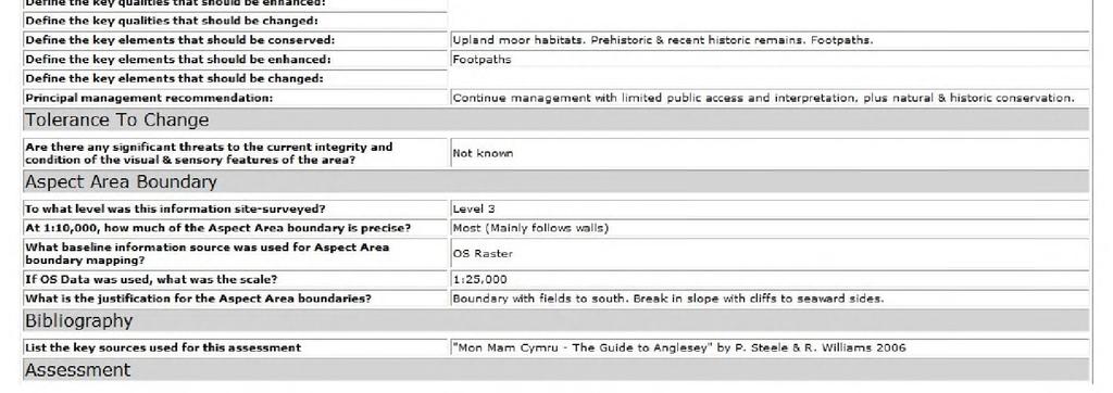
38 Appendix 2 LANDMAP Collector File Example 38
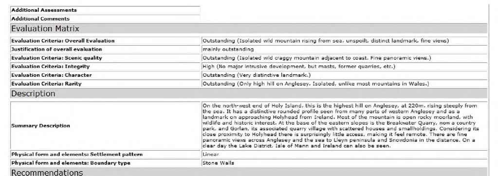
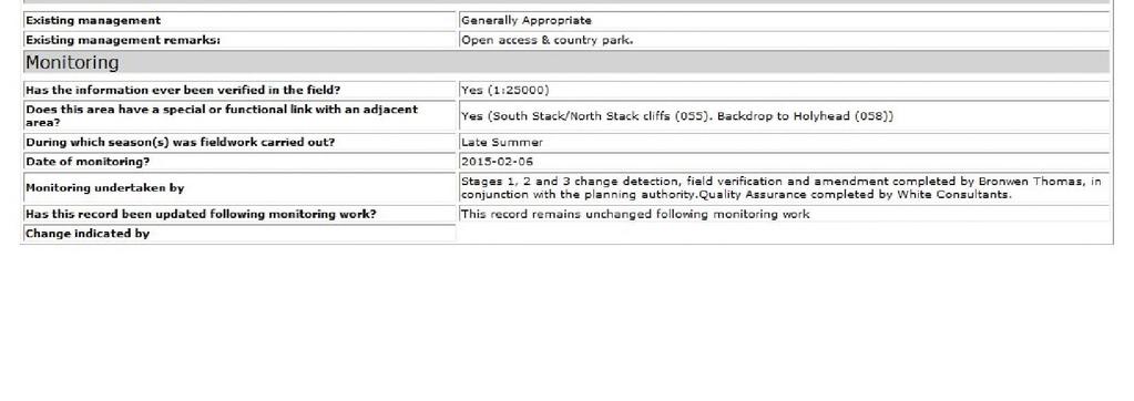
39 39
40 Appendix 3 Sensitivity and Capacity Maps Development typologies Site Typology Very Small Small Medium Large Very Large Indicative Criteria Up to 10 units (typically below 1 hectare in area) units (typically below 2 hectares in area) (typically below 10 hectares in area) (typically below 15 hectares in area) Over 200 units (typically over 15 hectares in area) Sensitivity Levels Sensitivity Very High High Medium- High Medium Low- Medium Low Definition The key characteristics and qualities of the landscape are very highly sensitive to change from the type and scale of development being assessed. The key characteristics and qualities of the landscape are highly sensitive to change from the type and scale of development being assessed. The key characteristics and qualities of the landscape are sensitive to change from the type and scale of development being assessed. Some of the key characteristics and qualities of the landscape are sensitive to change from the type and scale of development being assessed. Few of the key characteristics and qualities of the landscape are sensitive to change from the type and scale of development being assessed. Key characteristics and qualities of the landscape are robust and less likely to be adversely affected by the type and scale of development being assessed. Capacity within each LCA LCA Indicative Overall Capacity Sensitivity Gwynedd G01 Within all areas that contribute to the setting of the National Park there is typically no capacity for static caravan/chalet park developments. However, outside these areas there may be some capacity for very small to small, well designed and sited static caravan/chalet park developments. G02 Within the SLAs (and all areas that contribute to their setting and the setting of the National Park), there is typically no capacity for static caravan/chalet park developments. G03 Outside these areas there may be some capacity for sensitively sited and well-designed very small to small scale developments, which should relate well to the existing built environment/urban landcover. Within the SLA (and all areas that contribute to its setting and the setting of the National Park), there is typically no capacity for static caravan/chalet park developments. Outside these areas there may be some capacity for sensitively sited and well-designed very small to small scale developments, which should relate well to the existing built environment/urban landcover. 40
41 LCA Indicative Overall Capacity Sensitivity G04 Within the AONB and SLAs (and all areas that contribute to their setting and the setting of the National Park and WHS), there is typically no capacity for static caravan/chalet park developments. G05 G06 G07 G08 Outside these areas there may be some capacity for sensitively sited and well-designed very small to small scale developments, which should relate well to the existing built environment/urban landcover. Within the SLA (and all areas that contribute to its setting and the setting of the AONB and National Park), there is typically no capacity for static caravan/chalet park developments. Outside these areas there may be some capacity for sensitively sited and well-designed very small developments, which should relate well to the existing built environment/urban landcover. Typically no capacity for static caravan/chalet park developments (with the exception of very infrequent, very small scale development which should relate well to existing settlement/buildings). Due to the considerable numbers of static caravan/chalet parks, there is very limited capacity, if any, for further static caravan/chalet park developments and extensions. Within the areas that contribute to the setting of the SLAs and the National Park, there is typically no capacity for static caravan/chalet park developments. Outside these areas there may be some capacity for sensitively sited and well-designed very small to small scale developments, which should relate well to the existing built environment/urban landcover. G09 G10 In all cases development should avoid the undeveloped coastal edge and its immediate setting and should be clearly separated so that their effects remain local and there is no collective/cumulative defining influence on the landscape. Due to the considerable numbers of static caravan/chalet parks, in combination with the overall higher sensitivity, there is no capacity for further static caravan/chalet park developments and extensions. Within the AONB and SLAs (and all areas that contribute to their setting and the setting of the National Park), there is typically no capacity for static caravan/chalet park developments. Outside these areas there may be some capacity for sensitively sited and well-designed very small to small scale developments, which should relate well to the existing built environment/urban landcover. G11 In all cases development should avoid the undeveloped coastal edge and its immediate setting and should be clearly separated so that their effects remain local and there is no collective/cumulative defining influence on the landscape. Within areas that contribute to the outlook and setting of the National Park and ELDP Areas of Natural Beauty, there is typically no capacity for static caravan/chalet park developments. 41
42 LCA Indicative Overall Capacity Sensitivity Outside these areas there may be some capacity for sensitively sited and well-designed very small to small scale developments, which should relate well to the existing built environment/urban landcover. G12 There is typically no capacity for static caravan/chalet park developments throughout much of this LCA, although there may be limited capacity for very small to small, well designed and sited static caravan/chalet park developments to the south / south east of the LCA. G13 Due to the considerable numbers of static caravan/chalet parks, there is typically very limited capacity, if any, for further static caravan/chalet park developments and extensions. G14 Typically no capacity for static caravan/chalet park developments (with the exception of very infrequent sensitively sited and well designed very small developments, which should relate well to the existing built environment/urban). G15 Due to the considerable numbers of static caravan/chalet parks, there is typically very limited capacity, if any, for further static caravan/chalet park developments and extensions. G16 Within the SLA (and all areas that contribute to its setting and the setting of the National Park, WHS and AONBs), there is typically no capacity for static caravan/chalet park developments. Outside these areas there may be some capacity for sensitively sited and well-designed very small to small scale developments, which should relate well to the existing built environment/urban landcover. Anglesey A01 Typically no capacity for static caravan/chalet park developments within this LCA. A02 Within the AONB, and areas that contribute to its setting, there is typically no capacity for further static caravan/chalet park developments and extensions. Outside the AONB there may be very limited capacity for static caravan/chalet park developments and extensions, typically comprising very infrequent, very small scale well sited developments. A03 A04 A05 In all cases development should avoid the undeveloped coastal edge and its immediate setting and should be clearly separated so that their effects remain local and there is no collective/cumulative defining influence on the landscape. Typically no capacity for static caravan/chalet park developments or extensions within this LCA. Typically no capacity for further static caravan/chalet park developments or extensions within this LCA. Within the AONB and SLA (and all areas that contribute to their setting), there is typically no capacity for further static caravan/chalet park developments and extensions. Outside the AONB and SLA it is considered there may be some capacity for sensitively sited and well designed very small to small scale developments, which should relate well to the existing built environment/urban landcover. 42
43 LCA Indicative Overall Capacity Sensitivity A06 Within the AONB and SLAs (and all areas that contribute to their setting), there is typically no capacity for further static caravan/chalet park developments or extensions. A07 A08 A09 Outside the AONB and SLAs it is considered there may be some capacity for well sited very small to small scale developments. Typically no capacity for static caravan/chalet park developments. Within the AONB and SLAs (and all areas that contribute to their setting), there is typically no capacity for further static caravan/chalet park developments or extensions. Outside the AONB and SLAs it is considered there may be some capacity for very small to small scale developments, in particular where these may relate well to the existing built environment/settlements. Within the AONB and SLA (and areas that contribute to their setting), there is typically no capacity for further static caravan/chalet park developments and extensions. Outside the AONB there may be limited capacity for further very small to small well sited static caravan/chalet park developments and extensions. A10 A11 A12 A13 A14 A15 A16 In all cases development should avoid the undeveloped coastal edge and its immediate setting. Typically no capacity for static caravan/chalet park developments within this LCA. Within the AONB and SLA (and all areas that contribute to their setting), there is typically no capacity for further static caravan/chalet park developments or extensions. Outside the AONB and SLA it is considered there may be limited capacity for very small to small scale well sited developments. Within the AONB and SLAs (and all areas that contribute to their setting), there is typically no capacity for static caravan/chalet park developments. Outside the AONB and SLAs it is considered there may be some capacity for sensitively sited very small to small scale developments which should relate well to the existing built environment/urban landcover. Typically no capacity for further static caravan/chalet park developments and/or extensions within this LCA. Typically no capacity for static caravan/chalet park developments. Typically no capacity for static caravan/chalet park developments within this LCA. Within the AONB and SLA (and all areas that contribute to their setting), there is typically no capacity for static caravan/chalet park developments. Outside the AONB and SLA it is considered there may be limited capacity for very small to small scale developments, which should relate well to the existing built environment/urban landcover. 43
44 LCA Indicative Overall Capacity Sensitivity A17 Within the AONB and SLAs (and all areas that contribute to their setting), there is typically no capacity for further static caravan/chalet park developments and extensions. A18 Outside the AONB and SLAs it is considered there may be some capacity for very small to small scale developments, and/or limited capacity for well designed and sensitively sited larger scale developments, which should, in all cases relate well to the existing built environment/urban landcover. Although a lower sensitivity to static caravan/chalet park developments may indicate a higher capacity in this LCA, there may be very limited capacity, if any, for further static caravan/chalet park developments and extensions. This is due to the relatively small size of the LCA together with the amount of modern development which already influences the landscape (including RAF Valley Airfield and several larger scale static caravan/chalet parks). 44
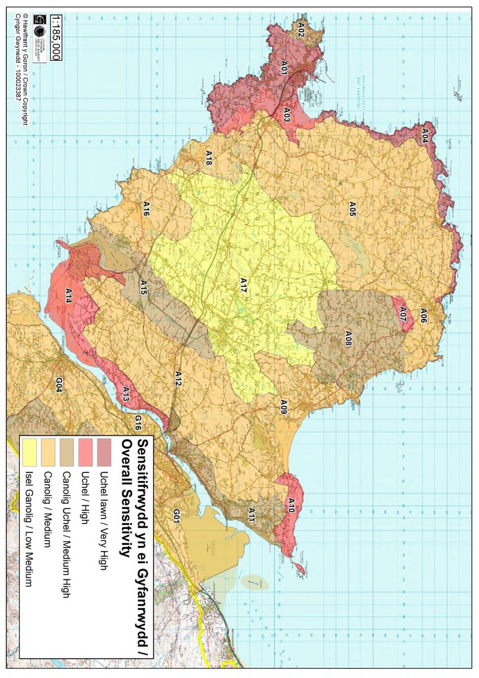
45 45
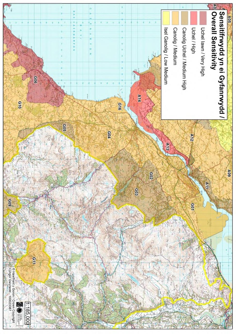
46 46
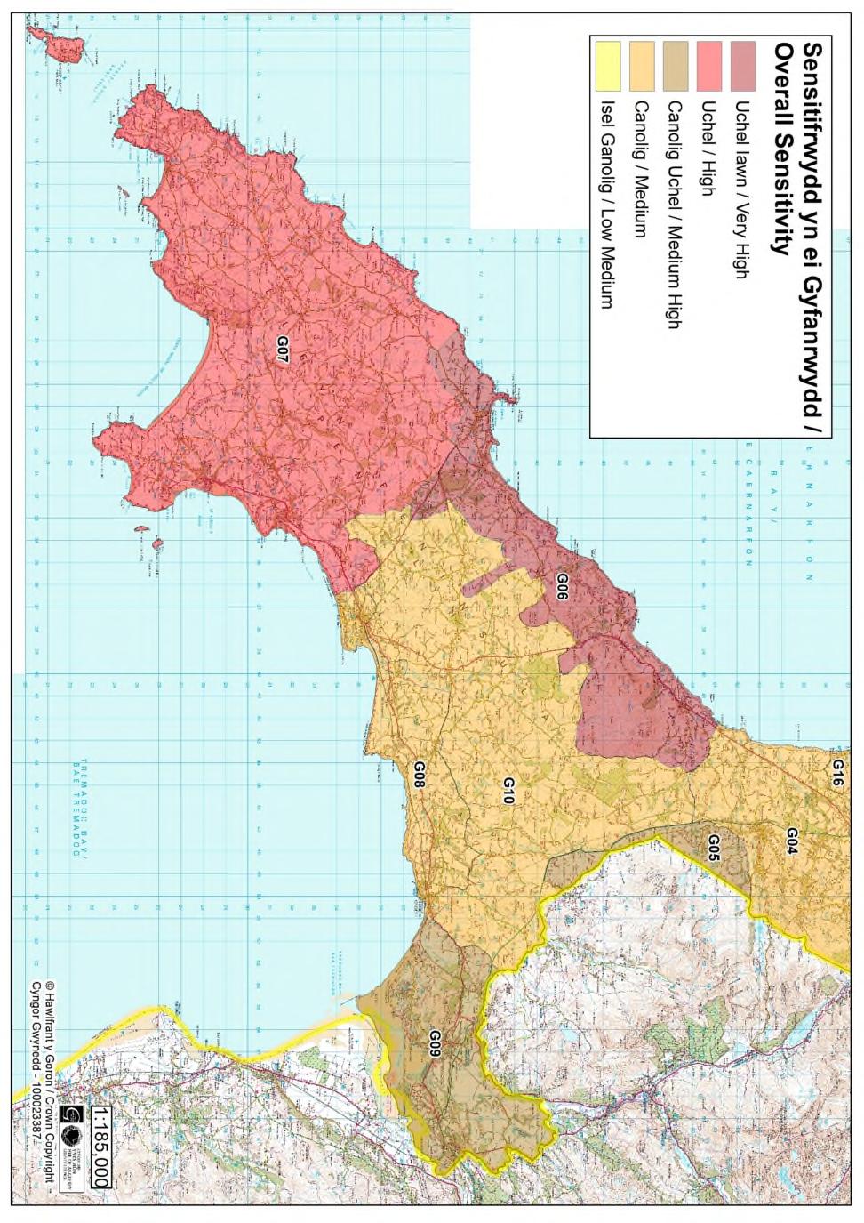
47 47
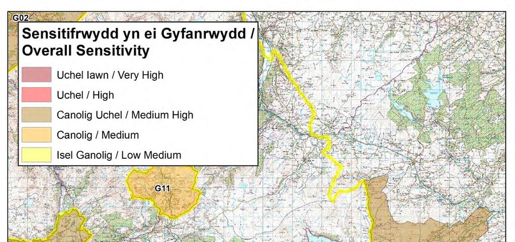
48 48
PLANNING COMMITTEE DATE: 07/09/2015 REPORT OF THE SENIOR MANAGER PLANNING AND ENVIRONMENT SERVICE CAERNARFON. Number: 4
 Number: 4 Application Number: C15/0034/37/LL Date Registered: 21/05/2015 Application Type: Full - Planning Community: Llanaelhaearn Ward: Llanaelhaearn Proposal: Location: Summary of the Recommendation:
Schedule of Planning Applications Committee Date: 23 May Reference: 06/17/0726/F Parish: Hemsby Officer: Mr J Beck Expiry Date:
 Schedule of Planning Applications Committee Date: 23 May 2018 Reference: 06/17/0726/F Parish: Hemsby Officer: Mr J Beck Expiry Date: 22-05-2018 Applicant: Proposal: Site: Mr Gillett Change of use to the
Cookham Parish Council s Response to The Draft Local Borough Plan
 Cookham Parish Council s Response to The Draft Local Borough Plan As Agreed at the Planning Committee Meeting on 10 th January 2017. Designation of Poundfield as a Local Green Space The Parish Council
STATEMENT OF OBJECTION TO THE PROPOSED DEVELOPMENT OF LAND AT CHURCH CLIFF DRIVE FILEY
 STATEMENT OF OBJECTION TO THE PROPOSED DEVELOPMENT OF LAND AT CHURCH CLIFF DRIVE FILEY You will be aware that Scarborough borough council have adopted a new local plan that includes land at Church Cliff
Development in the Green Belt
 Supplementary Planning Document: Development in the Green Belt Consultation Draft February 2013 Local Development Framework How to comment This document was published on 21st March 2013 and comments should
DEVELOPMENT MANAGEMENT REPORT
 ITEM A08-1 DEVELOPMENT MANAGEMENT REPORT TO: BY: DATE: DEVELOPMENT: SITE: WARD: APPLICATION: APPLICANT: Development Management Committee Development Manager Proposed live/work unit in connection with existing
DUNSFOLD NEIGHBOURHOOD PLAN Site Selection Policies
 DUNSFOLD NEIGHBOURHOOD PLAN Site Selection Policies The criteria for assessing sites for future housing and business development in Dunsfold are set out below. (Development criteria, covering what it is
LONGDEN VILLAGE DEVELOPMENT STATEMENT
 LONGDEN VILLAGE DEVELOPMENT STATEMENT 2017-2027 1 Longden Development Statement 2017-2027 15/01/18 1. Background 1.1 Longden Village Longden village is a very rural and traditional community first mentioned
Suffolk Coastal Local Plan Review Issues and Options, August 2017, Public Consultation
 Suffolk Coastal Local Plan Review Issues and Options, August 2017, Public Consultation Having reviewed the issues and options documents, the Society has made the following response: Part 1 - Strategic
Site Assessment Technical Document Appendix A: Glossary
 Central Bedfordshire Council www.centralbedfordshire.gov.uk Site Assessment Technical Document Appendix A: Glossary July 2017 1.1.11-1 - ii Appendix A: Glossary Term Agricultural Land Classification AONB
About 10% of the Borough's population lives in the seven rural parishes. Population figures from the 1991 census are given below:-
 8. THE DISTRICT VILLAGES 8.1 Population About 10% of the Borough's population lives in the seven rural parishes. Population figures from the 1991 census are given below:- Village No. of Persons Cottingham
Parish of Repton NEIGHBOURHOOD DEVELOPMENT PLAN
 Parish of Repton NEIGHBOURHOOD DEVELOPMENT PLAN BASIC CONDITIONS STATEMENT December 2018 CEF 4 Legal Requirements This statement has been produced by the NDP Working Group on behalf of Repton Parish Council
Local Development Scheme
 Local Development Scheme 2012 2016 The Local Development Scheme (LDS) is a project plan that outlines how and when the Authority will update its planning policies and other associated documents. It ensures
Neighbourhood Planning Local Green Spaces
 Neighbourhood Planning Local Green Spaces Introduction... 2 1. Why green space is important... 4 2. Neighbourhood plans and green space... 6 3. Evidence... 8 Statutory designations... 9 Green space audit...
List of Policies. SESPlan. None applicable. Consolidated Scottish Borders Local Plan 2011: POLICY G1 - QUALITY STANDARDS FOR NEW DEVELOPMENT
 List of Policies Local Review Reference: 15/00021/RREF Planning Application Reference: 15/00616/FUL Development Proposal: Installation of 16no solar photovoltaic (PV) panels to roof Location: Raebank,
2015/1020 Mr Edward Cockburn Caravan storage on hardcore base (Retrospective) Ranah Stones, Whams Road, Hazlehead, Sheffield, S36 4HT
 Ranah Stones, Whams Road, Hazlehead, Sheffield, S36 4HT") 2015/1020 Mr Edward Cockburn Caravan storage on hardcore base (Retrospective) Ranah Stones, Whams Road, Hazlehead, Sheffield, S36 4HT Dunford Parish Council have not commented Councillor Andrew Millner
2015/1020 Mr Edward Cockburn Caravan storage on hardcore base (Retrospective) Ranah Stones, Whams Road, Hazlehead, Sheffield, S36 4HT Dunford Parish Council have not commented Councillor Andrew Millner
RULE 6 (6) STATEMENT OF CASE
 STATEMENT OF CASE") RULE 6 (6) STATEMENT OF CASE Former Allerthorpe Park Golf Club, Allerthorpe, YO42 4RL Submitted on Behalf of Allerthorpe Parish Council Appeal by Turnwalk Ltd. and Park Leisure 2000 Ltd. Appeal Reference:
RULE 6 (6) STATEMENT OF CASE Former Allerthorpe Park Golf Club, Allerthorpe, YO42 4RL Submitted on Behalf of Allerthorpe Parish Council Appeal by Turnwalk Ltd. and Park Leisure 2000 Ltd. Appeal Reference:
PLANNING DECISION NOTICE
 PLANNING DECISION NOTICE TOWN AND COUNTRY PLANNING ACT, 1990 Applicant WILLITON VILLAGE HALL STEERING COMM. C/O ALISON CALLOWWAY 54 NORTHCROFT WILLITON TAUNTON TA4 4RT Date Registered 11/08/2006 Application
Newcourt Masterplan. November Exeter Local Development Framework
 Newcourt Masterplan November 2010 Exeter Local Development Framework Background The Exeter Core Strategy Proposed Submission sets out the vision, objectives and strategy for the development of Exeter up
Ipswich Issues and Options for the Ipswich Local Plan Review, August 2017, Public Consultation
 Ipswich Issues and Options for the Ipswich Local Plan Review, August 2017, Public Consultation Having reviewed the issues and options documents, the Society has made the following response: Part 1 Strategic
Settlement Boundaries Methodology North Northumberland Coast Neighbourhood Plan (August 2016)
") Introduction This background paper sets out a methodology for the definition of settlement boundaries in the North Northumberland Coast Neighbourhood Plan. The neighbourhood plan is planning positively
Introduction This background paper sets out a methodology for the definition of settlement boundaries in the North Northumberland Coast Neighbourhood Plan. The neighbourhood plan is planning positively
Great Easton Neighbourhood Plan Statement of Basic Conditions
 Great Easton Neighbourhood Plan 2017-2031 Statement of Basic Conditions OCTOBER 2016 GREAT EASTON PARISH COUNCIL Contents 1.0 Introduction....Page 2 2.0 Summary of Submission Documents and Supporting Evidence..
Sustainability Statement. Whitby Business Park Area Action Plan
 Sustainability Statement Whitby Business Park Area Action Plan November 2014 Contents Page 1. Introduction 1 2. Scoping 3 3. Sustainability Appraisal of Options 6 4. Assessment of Draft Area Action Plan
Ground Floor Flat 15 Redbourne Avenue London N3 2BP
 Location Ground Floor Flat 15 Redbourne Avenue London N3 2BP Reference: 17/4160/FUL Received: 28th June 2017 Accepted: 29th June 2017 Ward: West Finchley Expiry 24th August 2017 Applicant: Proposal: Mr
ROCHFORD LOCAL DEVELOPMENT FRAMEWORK: Sustainability Appraisal/ Strategic Environmental Assessment. Rochford Core Strategy Preferred Options Document
 ROCHFORD LOCAL DEVELOPMENT FRAMEWORK: Sustainability Appraisal/ Strategic Environmental Assessment Non Technical Summary Rochford Core Strategy Preferred Options Document October 2008 SUSTAINABILITY APPRAISAL
Derry City and Strabane District Council Planning Committee Report
 Derry City and Strabane District Council Planning Committee Report COMMITTEE DATE: 23 rd March 2016 APPLICATION No: APPLICATION TYPE: PROPOSAL: LOCATION: APPLICANT: LA11/2015/0395/F Residential Development
Babergh and Mid Suffolk Joint Draft Local Plan Consultation, August 2017, Public Consultation
 Babergh and Mid Suffolk Joint Draft Local Plan Consultation, August 2017, Public Consultation Having reviewed the documents, the Society has made the following response: Housing Delivery Q 7. Do you agree
Reference: 16/1447/FUL Received: 7th March 2016 Accepted: 7th March 2016 Ward: East Finchley Expiry 2nd May 2016
 Location 374B Long Lane London N2 8JX Reference: 16/1447/FUL Received: 7th March 2016 Accepted: 7th March 2016 Ward: East Finchley Expiry 2nd May 2016 Applicant: Ms Katrin Hirsig Proposal: Single storey
Change of use and development of land to form The Stour Valley Visitor Centre at Horkesley Park.
 Sue Jackson Principal Planning Officer Colchester Borough Council PO Box 889 Rowan House 33 Sheepen Road Colchester CO3 3WG By email only 2 Aug 2012 Dear Ms Jackson, 120965 Change of use and development
19 th October FAO Paul Lewis Planning Policy Branch Planning Division Welsh Assembly Government Cathays Park Cardiff CF10 3 NQ
 19 th October 2009 FAO Paul Lewis Planning Policy Branch Planning Division Welsh Assembly Government Cathays Park Cardiff CF10 3 NQ Dear Sir / Madam Technical Advice Note 6 Planning for Sustainable Rural
Neighbourhood Plan Representation
 Date: 10 th November 2017 Neighbourhood Plan Representation Land to the east of Callow Hill Road, Alvechurch Introduction This representation has been prepared by RPS Planning and Development on behalf
OKEFORD FITZPAINE NEIGHBOURHOOD PLAN
 OKEFORD FITZPAINE NEIGHBOURHOOD PLAN Dear Parishioner, The Neighbourhood Plan Project Team have prepared this leaflet to summarise the full Neighbourhood Plan document. It provides a summary of the Vision,
2. The application, which is a full plans application, is for a commercial development comprising B1, D1, D2 and A3 uses.
 Former Taff Vale Shopping Centre, Taff Street, Pontypridd, CF37 4TR PLANNING APPLICATION SUPPORTING STATEMENT May 2017 Ref.11431/1 INTRODUCTION AND APPLICATION CONTEXT 1. This planning application statement
EXTRACT FROM THE CUDDINGTON NEIGHBOURHOOD PLAN The Policies
 EXTRACT FROM THE CUDDINGTON NEIGHBOURHOOD PLAN The Policies Environment and Landscape Policy 1 - Landscape Setting Development should respect and wherever possible enhance the landscape setting of Cuddington
The Gwennap Parish Vision Statement
 QUICK GUIDE What is a Neighbourhood Development Plan? Ultimately it is a document used by developers or anyone wishing to submit a planning application that describes the vision, strategy, plans, regeneration,
REFERENCE: B/03745/12 Received: 02 October 2012 Accepted: 05 October 2012 WARD(S): Totteridge Expiry: 30 November 2012.
: Totteridge Expiry: 30 November 2012.") LOCATION: 15A Pyecombe Corner, London, N12 7AJ REFERENCE: B/03745/12 Received: 02 October 2012 Accepted: 05 October 2012 WARD(S): Totteridge Expiry: 30 November 2012 Final Revisions: APPLICANT: PROPOSAL:
LOCATION: 15A Pyecombe Corner, London, N12 7AJ REFERENCE: B/03745/12 Received: 02 October 2012 Accepted: 05 October 2012 WARD(S): Totteridge Expiry: 30 November 2012 Final Revisions: APPLICANT: PROPOSAL:
Planning, Design and Access Statement
 Planning, Design and Access Statement November 2018 Demolition of Lansdowne House and garage, and part of the existing adjacent William Ainge Court development, and redevelopment and reconfiguration of
PWYLLGOR CYNLLUNIO DYDDIAD: 23/03/2015 ADRODDIAD UWCH REOLWR GWASANAETH CYNLLUNIO AC AMGYLCHEDD CAERNARFON. Number: 1
 Number: 1 Application Number: C14/1218/33/LL Date Registered: 12/01/2015 Application Type: Full - Planning Community: Buan Ward: Efailnewydd/Buan Proposal: CHANGE OF USE OF A FIELD TO FORM A TOURING CARAVAN
6. THE COAST POLICY INDEX
 6. THE COAST POLICY INDEX LP/C1 Development within the Coastal Zone Page 90 LP/C2 Piers & Harbours Page 92 LP/C3 Fish Farms Page 94 LP/C4 Coastal Erosion Page 96 THE ORKNEY LOCAL PLAN - Coastal Policies
2014/0590 Reg Date 26/06/2014 Chobham
 2014/0590 Reg Date 26/06/2014 Chobham LOCATION: PROPOSAL: TYPE: APPLICANT: OFFICER: ASCOT PARK POLO CLUB, WESTCROFT PARK FARM, WINDLESHAM ROAD, CHOBHAM, WOKING, GU24 8SN Erection of a two storey detached
4 RESIDENTIAL ZONE. 4.1 Background
 4 RESIDENTIAL ZONE 4.1 Background The residential areas within the City are characterised by mainly lowrise dwellings sited on individual allotments. Past architectural styles, settlement patterns and
ALLERTHORPE NEIGHBOURHOOD PLAN
 Allerthorpe s Neighbourhood Plan sets out a vision for the Parish for the next 15 years (2018 2033) that builds on and reflects the opinions and views of parish residents. VISION In 2033 Allerthorpe will
Plumpton Neighbourhood Development Plan Revised Pre Submission Document - Regulation 14 Consultation
 REPRESENTATIONS... Plumpton Parish Council Plumpton Neighbourhood Development Plan Revised Pre Submission Document - Regulation 14 Consultation Representations submitted on behalf of: Cala Homes (South
Change Paper / Date CAIRNGORMS NATIONAL PARK AUTHORITY
 Change Paper / Date CAIRNGORMS NATIONAL PARK AUTHORITY Title: Prepared by: REPORT ON CALLED-IN PLANNING APPLICATION FIONA MURPHY (PLANNING OFFICER DEVELOPMENT MANAGEMENT) DEVELOPMENT PROPOSED: REFERENCE:
Draft Island Development Plan
 Draft Island Development Plan February 2015 Written Statement Contents Part One 1 About the Island Development Plan What is the Island Development Plan? What is the Island Development Plan used for? Structure
Garages To Rear Of The Willows 1025 High Road London N20 0QE
 Location Garages To Rear Of The Willows 1025 High Road London N20 0QE Reference: 15/03944/FUL Received: 25th June 2015 Accepted: 2nd July 2015 Ward: Totteridge Expiry 27th August 2015 Applicant: Mr Alex
3. Neighbourhood Plans and Strategic Environmental Assessment
 1. Introduction This report sets out a draft Screening Determination for the Preston Parish Council s Neighbourhood Plan and has been prepared by rth Hertfordshire District Council. The purpose of the
Derry City and Strabane District Council Planning Committee Report
 Derry City and Strabane District Council Planning Committee Report COMMITTEE DATE: 20.12.2017 APPLICATION No: APPLICATION TYPE: PROPOSAL: LOCATION: APPLICANT: AGENT: A/2014/0495/F Full Construction of
LETTER OF OBJECTION LAND TO THE SOUTH WEST OF FORGE GARAGE, HIGH STREET, PENSHURST, KENT, TN11 8BU
 Senior Planning Officer Andrew Byrne Sevenoaks District Council Community & Planning Services PO Box 183 Argyle Road Sevenoaks Kent TN13 1GN 04 November 2011 Your Ref: 11/02258/FUL For the attention of
Basic Conditions Statement Exmouth Neighbourhood Plan
 Exmouth Neighbourhood Plan 2018-2031. On behalf Exmouth Neighbourhood Plan Steering Group July 2018 Table of Contents 1. Introduction... 4 2. Legal Requirements... 5 3. Why there is a need for a Neighbourhood
SOUTH CAMBRIDGESHIRE DISTRICT COUNCIL. Planning and New Communities Director
 SOUTH CAMBRIDGESHIRE DISTRICT COUNCIL REPORT TO: Planning Committee 5 June 2013 AUTHOR/S: Planning and New Communities Director S/0747/13/FL HISTON Construction of Car Park at Histon Baptist Church, Station
CA//16/00504/FUL. Canterbury City Council Military Road Canterbury Kent CT1 1YW. Crown copyright and database rights 2016 Ordnance Survey
 O Scale 1:1,250 Map Dated: 09/05/2016 CA//16/00504/FUL Crown copyright and database rights 2016 Ordnance Survey 100019614 Canterbury City Council Military Road Canterbury Kent CT1 1YW AGENDA ITEM NO 13
3 Abbey View Mill Hill London NW7 4PB
 Location 3 Abbey View Mill Hill London NW7 4PB Reference: 15/03203/HSE Received: 26th May 2015 Accepted: 16th June 2015 Ward: Mill Hill Expiry 11th August 2015 Applicant: Proposal: Mr Richard Benson Alterations
Planning Committee 04/02/2015 Schedule Item 6. Smith Farm Estate, Old Bridge Close, Northolt, UB5 6UA.
 Planning Committee 04/02/2015 Schedule Item 6 Ref: Address: Ward: Proposal: PP/2014/5145 Smith Farm Estate, Old Bridge Close, Northolt, UB5 6UA. Greenford Broadway Installation of sports pitch, reconstruction
1 The development hereby permitted shall be carried out in accordance with the following approved plans:
 Location 59 Greenway Close London N20 8ES Reference: 16/00011/HSE Received: 30th December 2015 Accepted: 7th January 2016 Ward: Totteridge Expiry 3rd March 2016 Applicant: Mr Ankit Shah Proposal: Part
Annex B: SWDP Objectives mapped against Worcestershire SCS Objectives. Annex B: SWDP Objectives mapped against Worcestershire SCS Objectives
 Annex B: SWDP mapped against SCS Annex B: SWDP mapped against SCS in SCS Economic Success That Is Shared By All 1. A skilled prosperous economy 1. Development that focuses on improving A. Enhanced prosperity
49 Broughton Avenue London N3 3EN
 Location 49 Broughton Avenue London N3 3EN Reference: 17/3448/RCU Received: 30th May 2017 Accepted: 1st June 2017 Ward: Finchley Church End Expiry 27th July 2017 Applicant: Mr P Atwal Proposal: Erection
Appendix A: Retail Planning Assessment
 Rotherham Town Centre Masterplan Appendix A: Retail Planning Assessment 139 Appendix A Rotherham Town Centre Masterplan Retail Planning Background and Policy Context 1. Introduction 1.1 The Masterplan
CA//17/02777/FUL. Scale 1:1,250. Planning Services Canterbury City Council Military Road Canterbury Kent CT1 1YW
 O CA//17/02777/FUL Scale 1:1,250 Map Dated: 15/03/2018 Planning Services Canterbury City Council Military Road Canterbury Kent CT1 1YW AGENDA ITEM NO 16 PLANNING COMMITTEE APPLICATION NUMBER: SITE LOCATION:
Report Author/Case Officer: Paul Keen Senior Planning Officer (Dev Control) Contact Details:
 Contact Details:") APP 03 Application Number: 17/02060/FUL Description A full planning application for the demolition of an existing bungalow (C3 use class) and associated out buildings and the erection of two, two storey
APP 03 Application Number: 17/02060/FUL Description A full planning application for the demolition of an existing bungalow (C3 use class) and associated out buildings and the erection of two, two storey
Tāhuhu whakaruruhau ā-taone The sheltering ridge pole
 B2. Tāhuhu whakaruruhau ā-taone - Urban growth and form B2.1. Issues Tāhuhu whakaruruhau ā-taone The sheltering ridge pole Auckland s growing population increases demand for housing, employment, business,
Cotswolds AONB Landscape Strategy and Guidelines. June 2016
 Cotswolds AONB Landscape Strategy and Guidelines June 2016 Cotswolds AONB Landscape Strategy and Guidelines Introduction The evolution of the landscape of the Cotswolds AONB is a result of the interaction
To secure a Green Belt around Cambridge whose boundaries are clearly defined and which will endure for the plan period and beyond.
 4. GREEN BELT OBJECTIVES GB/a GB/b GB/c GB/d To secure a Green Belt around Cambridge whose boundaries are clearly defined and which will endure for the plan period and beyond. To maintain the purposes
18 Birkbeck Road London NW7 4AA. Reference: 15/02994/HSE Received: 14th May 2015 Accepted: 26th May 2015 Ward: Mill Hill Expiry 21st July 2015
 Location 18 Birkbeck Road London NW7 4AA Reference: 15/02994/HSE Received: 14th May 2015 Accepted: 26th May 2015 Ward: Mill Hill Expiry 21st July 2015 Applicant: Proposal: Mrs Tania Kallis Single storey
Designations protecting the historic designed landscape
 Historic Landscape Project Designations protecting the historic designed landscape A. Key national designations affecting the historic environment: 1. Listed buildings 2. Scheduled Monuments (generally
WINCHESTER TOWN 3.1 LOCATION, CHARACTERISTICS & SETTING
 WINCHESTER TOWN 3.1 LOCATION, CHARACTERISTICS & SETTING 3.1.1 The area referred to by the City Council, as Winchester Town, consists of the Winchester Wards plus the adjoining built up areas of Badger
Reference: 16/1234/HSE Received: 25th February 2016 Accepted: 2nd March 2016 Ward: High Barnet Expiry 27th April 2016
 Location 7 Sunset View Barnet EN5 4LB Reference: 16/1234/HSE Received: 25th February 2016 Accepted: 2nd March 2016 Ward: High Barnet Expiry 27th April 2016 Applicant: Proposal: Mr & Mrs Peter & Anny Woodhams
Definition of Cumulative Landscape and Visual Effects
 SECTION 5: GUIDANCE FOR ASSESSING CUMULATIVE LANDSCAPE AND VISUAL EFFECTS 5.1 Although this landscape sensitivity and capacity study has identified that parts of the National Park may be able to accommodate
46 Burley Street, Leeds, LS3 1LB Retail Statement
 , LS3 1LB Retail Statement , LS3 1LB Retail Statement October 2014 Indigo Planning Indigo Planning Limited Toronto Square Leeds LS1 2HJ Tel: 0113 380 0270 Fax: 0113 380 0271 info@indigoplanning.com indigoplanning.com
an Inspector appointed by the Secretary of State for Communities and Local Government
 Appeal Decision Site visit made on 23 January 2017 by Gareth Wildgoose BSc (Hons) MSc MRTPI an Inspector appointed by the Secretary of State for Communities and Local Government Decision date: 6 February
Perth and Kinross Council Development Management Committee 20 February 2013 Report of Handling by Development Quality Manager
 Perth and Kinross Council Development Management Committee 20 February 2013 Report of Handling by Development Quality Manager 4(4)(iii) 13/81 Erection of sports hall, associated changing facilities, offices
SECTION 7A: WHAKARONGO RESIDENTIAL AREA
 SECTION 7A: WHAKARONGO RESIDENTIAL AREA CONTENTS 7A.1 Introduction 1 7A.2 Resource Management Issues 1 7A.3 Objectives and Policies 1 7A.4 Methods 4 7A.5 Residential Zone 4 7A.5.1 Rules: Controlled Activities
DEVELOPMENT MANAGEMENT REPORT
 ITEM A07-1 DEVELOPMENT MANAGEMENT REPORT TO: BY: Development Management Committee (South) Development Manager DATE: 21 June 2016 DEVELOPMENT: SITE: WARD: APPLICATION: APPLICANT: Outline application for
I615. Westgate Precinct
 I615. Westgate Precinct I615.1. Precinct Description The Westgate Precinct is located approximately 18km west of the Auckland city centre. There are seven Sub-precincts in the Westgate Precinct: Sub-precinct
Test Valley Borough Council Southern Area Planning Committee 8 January 2019
 ITEM 11 APPLICATION NO. 18/02218/FULLS APPLICATION TYPE FULL APPLICATION - SOUTH REGISTERED 23.08.2018 APPLICANT Rugby Football Union SITE The Trojans Club, Stoneham Lane, Eastleigh, SO50 9HT, CHILWORTH
Rev John Withy, Sion House, 120 Melmount Road, Sion Mills
 Derry City and Strabane District Council Planning Committee Report COMMITTEE DATE: 4 th October 2017 APPLICATION No: APPLICATION TYPE: PROPOSAL: LOCATION: APPLICANT: AGENT: LA11/2016/0701/F Full Retrospective
Case Officer: Sarah Kay File No: CHE/14/00515/REM Tel. No: (01246) Plot No: 2/6132 Ctte Date: 15 th September 2014 ITEM 1
 Plot No: 2/6132 Ctte Date: 15 th September 2014 ITEM 1") Case Officer: Sarah Kay File No: CHE/14/00515/REM Tel. No: (01246) 345786 Plot No: 2/6132 Ctte Date: 15 th September 2014 ITEM 1 APPROVAL OF RESERVED MATTERS FROM APPLICATION CHE/12/00234/OUT (1) LAYOUT,
Case Officer: Sarah Kay File No: CHE/14/00515/REM Tel. No: (01246) 345786 Plot No: 2/6132 Ctte Date: 15 th September 2014 ITEM 1 APPROVAL OF RESERVED MATTERS FROM APPLICATION CHE/12/00234/OUT (1) LAYOUT,
Planning and Regulatory Committee 20 May Applicant Local Councillor Purpose of Report
 Planning and Regulatory Committee 20 May 2014 7. APPLICATION FOR PLANNING PERMISSION FOR THE CARRYING-OUT OF DEVELOPMENT PURSUANT TO PLANNING PERMISSION REFERENCE NUMBER 603451 DATED 28 FEBRUARY 2007 WITHOUT
Item No: 4 Reference: B/16/00635/FUL. Parish: BENTLEY Ward Member: Cllrs Stephen William and John Hinton
 Item No: 4 Reference: B/16/00635/FUL Parish: BENTLEY Ward Member: Cllrs Stephen William and John Hinton Location: Proposal: Applicant: Bentley Plants Ltd, Bergholt Road, Bentley, IPSWICH IP9 2DQ Change
5 Gratton Terrace London NW2 6QE. Reference: 17/5094/HSE Received: 4th August 2017 Accepted: 7th August 2017 Ward: Childs Hill Expiry 2nd October 2017
 Location 5 Gratton Terrace London NW2 6QE Reference: 17/5094/HSE Received: 4th August 2017 Accepted: 7th August 2017 Ward: Childs Hill Expiry 2nd October 2017 Applicant: WSD (Gratton) Ltd Proposal: The
Copyright Nigel Deeley and licensed for reuse under this Creative Commons Licence
 1 Copyright Nigel Deeley and licensed for reuse under this Creative Commons Licence Prepared by the Neighbourhood Plan Steering Group on behalf of Garway Parish Council with assistance from 2 Table of
South Worcestershire Development Plan. South Worcestershire Design Guide Supplementary Planning Document
 South Worcestershire Development Plan South Worcestershire Design Guide Supplementary Planning Document Statement of Consultation: Early Engagement Scoping Paper February 2017 1. Introduction 1.1 This
Introduction. Grounds of Objection
 Planning application ref. number 18/04496/APP Planning application to Aylesbury Vale District Council for the erection of 17 dwellings and associated works to the South of Hogshaw Road Granborough. Granborough
Reference: 15/06961/RCU Received: 13th November 2015 Accepted: 17th November 2015 Ward: Coppetts Expiry 12th January 2016
 Location 91 Manor Drive London N20 0XD Reference: 15/06961/RCU Received: 13th November 2015 Accepted: 17th November 2015 Ward: Coppetts Expiry 12th January 2016 Applicant: Mr Christos Papadopoulos Proposal:
26 September 2014 CONSULTATION EXPIRY : APPLICATION EXPIRY : 22 July 2014 SUMMARY RECOMMENDATION: PERMISSION
 Item No.: 5 The information, recommendations and advice contained in this report are correct as at the date of preparation, which is more than one week in advance of the Committee meeting. Because of the
SOUTH CAMBRIDGESHIRE DISTRICT COUNCIL. REPORT TO: Planning Committee 1 April 2015 Planning and New Communities Director
 SOUTH CAMBRIDGESHIRE DISTRICT COUNCIL REPORT TO: Planning Committee 1 April 2015 AUTHOR/S: Planning and New Communities Director Application Number: Parish(es): Proposal: Site address: Applicant(s): Recommendation:
APP/G1630/W/15/
 Appeal Decision Site visit made on 20 October 2015 by William Fieldhouse BA (Hons) MA MRTPI an Inspector appointed by the Secretary of State for Communities and Local Government Decision date: 20 November
1 The development hereby permitted shall be carried out in accordance with the following approved plans:
 Location The Avenue Tennis Club The Avenue London N3 2LE Reference: 16/6509/FUL Received: 10th October 2016 Accepted: 10th October 2016 Ward: Finchley Church End Expiry 5th December 2016 Applicant: Mrs
Rochford District Council Allocations Development Plan Document: Discussion and Consultation Document Sustainability Appraisal
 Option SWH1 Balanced Communities Option SWH1 1 To ensure the delivery of high quality sustainable communities where people want to live and work Will it ensure the phasing of infrastructure, including
Parish: Westbourne. Ward: Westbourne WE/16/01078/COU
 Parish: Westbourne Ward: Westbourne WE/16/01078/COU Proposal Change of use of land to a private gypsy and traveller caravan site consisting of 1 no. mobile home, 1 no. utility building, 1 no. touring caravan
Wallingford Neighbourhood Plan
 Wallingford Neighbourhood Plan Introduction What is neighbourhood planning? Neighbourhood planning was introduced by the Localism Act 2011 to give local people more influence over how development comes
BLEWBURY NEIGHBOURHOOD DEVELOPMENT PLAN STATEMENT OF BASIC CONDITIONS
 BLEWBURY NEIGHBOURHOOD DEVELOPMENT PLAN STATEMENT OF BASIC CONDITIONS Introduction 1.1 This statement has been prepared to accompany the submission of the Blewbury Neighbourhood Development Plan ( the
A Growing Community Rural Settlement Areas
 Town of Huntsville Official Plan Review - POLICY BACKGROUND PAPER A Growing Community Rural Settlement Areas BACKGROUND: In addition to the fully municipally-serviced Urban Settlement Area and the Hidden
Planning and Sustainability Statement
 Land adjacent to Manor Farm, Catterick Village Pallett Hill Sand and Gravel Co Ltd Proposed 10 new dwellings, (6 No market dwellings and 4 No affordable dwellings) with access, associated car parking and
PLANNING STATEMENT. Market House Market Place Kingston upon Thames KT1 1JS
 PLANNING STATEMENT To support planning and listed building consent applications for change of use from Class A1 shop and Class A3 cafe to Class A3 restaurant at: Market House Market Place Kingston upon
Interim Advice Note 76 / 06 ASSESSMENT PART 1 AIMS AND OBJECTIVES OF ENVIRONMENTAL ASSESSMENT. Contents
 Interim Advice Note 76 / 06 VOLUME 11 SECTION 1: ENVIRONMENTAL ASSESSMENT INTRODUCTION PART 1 AIMS AND OBJECTIVES OF ENVIRONMENTAL ASSESSMENT Contents 1. Introduction and Application 2. Aims and Objectives
I539. Smales 2 Precinct
 I539. Smales 2 Precinct I539.1. Precinct Description The Smales 2 Precinct applies to a 4.8 hectare block of land located on the southern side of Northcote Road and fronting Lake Pupuke, Takapuna. The
Perth and Kinross Council Development Management Committee 8 June Pre-Application Report by Development Quality Manager
 Perth and Kinross Council Development Management Committee 8 June 2016 5(3)(i) 16/259 Pre-Application Report by Development Quality Manager Residential development at St Martins Road, Land 120 metres West
REFERENCE: B/00601/12 Received: 11 February 2012 Accepted: 21 February 2012 WARD(S): High Barnet Expiry: 17 April 2012
: High Barnet Expiry: 17 April 2012") LOCATION: 37 Kings Road, Barnet, Herts, EN5 4EG REFERENCE: B/00601/12 Received: 11 February 2012 Accepted: 21 February 2012 WARD(S): High Barnet Expiry: 17 April 2012 Final Revisions: APPLICANT: PROPOSAL:
LOCATION: 37 Kings Road, Barnet, Herts, EN5 4EG REFERENCE: B/00601/12 Received: 11 February 2012 Accepted: 21 February 2012 WARD(S): High Barnet Expiry: 17 April 2012 Final Revisions: APPLICANT: PROPOSAL:
2A District-wide Policies
 2A Introduction This Chapter contains policies which are relevant to subdivision, use and development activities occurring across all zones and areas of the District. The policies in this Chapter implement