A L F O N S O A R C H I T E C T S
|
|
|
- Brianna Sanders
- 5 years ago
- Views:
Transcription
1 A L F O N S O A R C H I T E C T S

2 A L M A T H E P I E R O F S T. P E T E R S B U R G A L F ALFONSO O N S O A R ARCHITECTS C H I T E C T S
3 ALMA
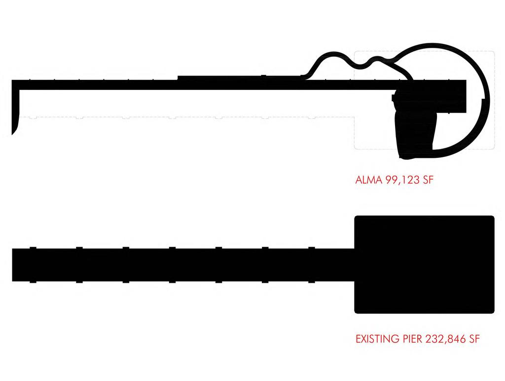
4 1. Please demonstrate how the project fits within the Pinellas County Water and Navigation permit requirements as it relates to pre versus proposed wall area, roof area, and height differences. WE SPOKE WITH DAVID WALKER AT PINELLAS COUNTY. SEE ATTACHED PLAN AND ELEVATION AREAS. 11. Please confirm that a variance from PCWCNA is no longer required for this project, and that it complies with the FAA cone restrictions for the site. CONFIRMED IN WRITING, SHOWN IN ATTACHED DIAGRAM, AND CONFIRMED WITH DAVID WALKER AT PINELLAS COUNTY WATER PERMIT DEPARTMENT.differences
5
6
7 2. Expound upon and clarify the programming opportunities in the proposed tower structure and how the anticipated modes of transportation will adequately support the tower and event space program opportunities. SEE ATTACHED PLANS FOR EVENT VEHICLE STAGING.
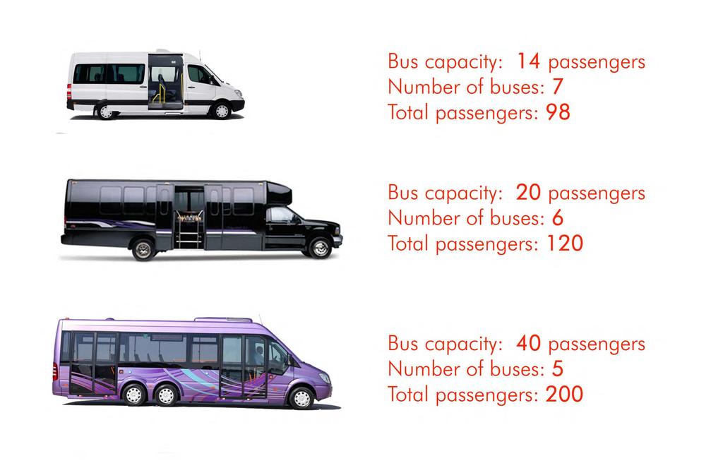
8 3. Please provide a cross section of the pier bridge approach at a minimum of three (3) distinct distances over the water. The distances could be at the 1/3, 1/2 and 2/3 points out over the water, or at reasonable locations based on the features of your concept. In the cross sections, please indicate (with dimensions) zones for pedestrian and bicycle uses and those for vehicular and tram uses. SEE ATTACHED. 2. The activities provided for at the pier head in your proposal could often lead to large numbers of people attending special events. Tram or trolley access might not be appropriate for many of these. Is there a plan to provide for other options to address such needs, and if not, will addressing this affect your cost plan? If it would affect the cost, what would need to be eliminated in order to accommodate such access? SEE ATTACHED PLANS FOR SPECIAL EVENT VEHICLE STAGING.
9 1. In all cases, the information given on transportation options along the pier approach typically focused more on the needs of the pier users and did not as carefully address the needs of maintenance and service vehicles. Please give an assessment of how these other essential needs will interact with and interfere with your plan to transport users. SEE ATTACHED PLAN SHOWING FIRE DEPARTMENT ACCESS AND ENLARGED SECTION SHOWING SPACE FOR MAINTENANCE VEHICLES AND PEDESTRIANS.
10 1. How wide is the approach to the pier head? Could it support the trolley/looper vehicles and still provide room for pedestrians and bikes? APPROACH IS 30 WIDE, YES. 2. Could limos and/or valet services use the pier approach during special events at the ballroom? YES. 8. Please confirm how guests will be transported to the Waterside Tower and Dance Hall CITY OPERATED PIER SHUTTLE, IN ADDITION MULTI PASSENGER VEHICLES COULD BE ALLOWED OUT ONTO PIER. MULTIPLE VEHICLES CAN BE STAGED AT THE TRANSPORTATION PLAZA AND PIER HEAD..

11 ENLARGED PIER PLAN

12 ENLARGED PIER PLAN
13
14
15
16 EMERGENCY, SERVICE, AND SPECIAL VEHICLE ACCESS

17 SPECIAL EVENTS TRANSPORTATION

18 SPECIAL EVENTS VEHICLE STAGING TRANSPORTATION PLAZA

19 SPECIAL EVENTS VEHICLE STAGING TOWER PIAZZA
20
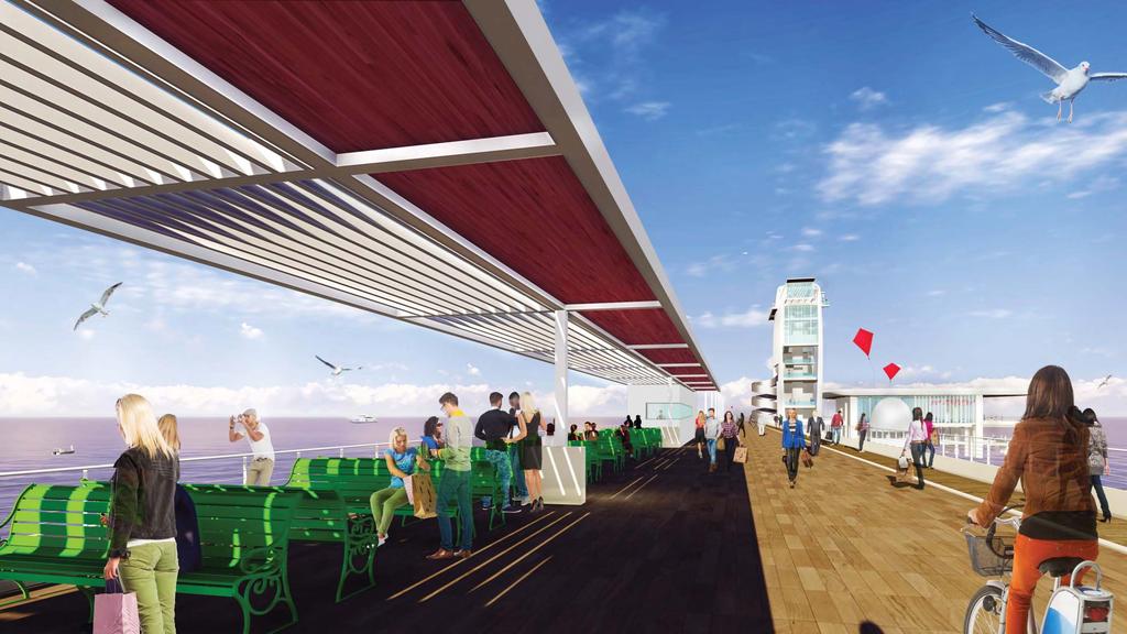
21 9. Please confirm any activation plans for the pedestrian pier promenade SEE ATTACHED PLANS FOR PEDESTRIAN/BIKING/FISHING/ETC. 6. In the latest design, how big is the kiosk on the approach? Does it have power, water and sewer? THE KIOSK IS 10 BY 15. POWER, WATER, AND SEWER IS PROVIDED. 12. Is the roof of the shelter in the middle of the approach solid to protect from rain or designed to just create dappled shade? PARTIALLY SOLID, PARTIALLY LOUVERED.
22
23 1. Explain how you envision the servicing of your solution will occur. Servicing relates to deliveries, maintenance, locations for support services equipment, etc. specifically explain distances and how you would maneuver to accomplish this. SEE ATTACHED PLANS. 8. How many square feet is the tower bar? 735 SF 9. What are the dimensions of the actual dance floor (length and width, not just square footage)? APPROX. 70 X 88 WITH 51 X 87 EXTERIOR SPACE. Is there also room for storage of tables and chairs when not needed for an event? YES - SEE ATTACHED PLAN. 10. Where is the "back of house" space to support the ballroom, and the tower restaurant? SEE ATTACHED PLAN. 7. Please confirm how all back of house operations will be addressed at the Waterside Tower and Dance Hall at the pier head. SEE ATTACHED PLAN.

24 PIER HEAD- LEVEL 1
25 PIER HEAD- LEVEL 2
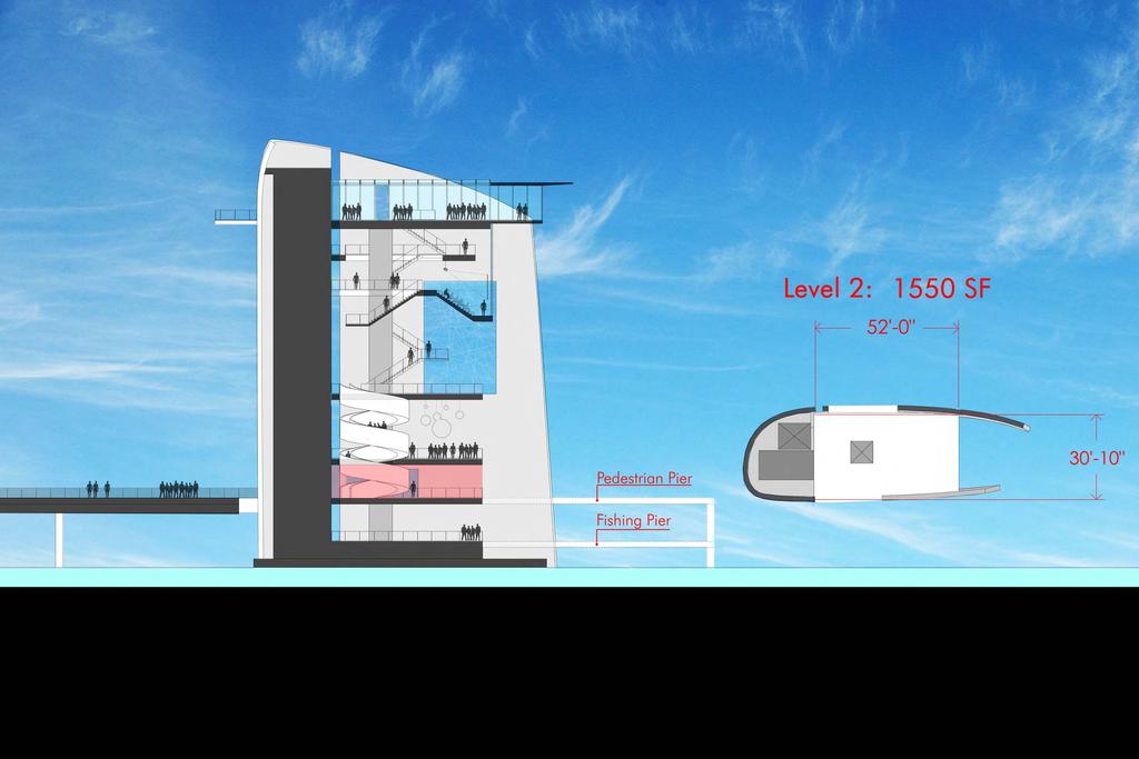
26 3. I'm not clear, after the reductions were made to bring the project within the budget, how many floors are in the latest tower design? What are the approximate dimensions of each floor (approximate length and width, not just square footage)? Which floors are air conditioned? TOTAL OF 7 FLOORS SEE ATTACHED TOWER SECTION AND ON PLANS FOR DIMENSIONS AND AREAS. PARTIAL FLOOR 6 (LECTURE AUDITORIUM) AND FLOOR 7 OBSERVATION DECK ARE AIR CONDITIONED. 4. How many can be seated in the tower auditorium? 70
27
28
29
30
31
32
33
34 7. How many toilet fixtures are in the entire project and where are they located? SEE ATTACHED PLANS FOR RESTROOM LOCATIONS. TOILET FIXTURE QUANTITIES TO BE DETERMINED AT TA LATER DATE.
35 BATHROOM LOCATIONS
36 1. Please confirm how your proposed concept supports the Plan Themes as noted in the draft St. Petersburg Waterfront Master Plan, including: THE ALMA PROJECT PROVIDES A DIRECT RESPONSE TO THE FOLLOWING THEMES: a. Stewardship of the waterfront environment a sustainable relationship between the natural and built environments b. Enhancing the experience of the water expanding St. Petersburg as a waterfront destination for boaters and non-boaters c. An active waterfront parks system diversifying the activities of the waterfront to meet a growing community d. Economically vibrant downtown places leveraging the economic potential of in-water and upland areas along the water s edge e. A connected, accessible downtown + waterfront, continuous linkages, service oriented parking + transit, increased public access 2. Confirm how your solution is meeting the intent of the waterfront master plan, especially utilization of uplands i.e. restaurants. TO BE DISCUSSED IN PRESENTATION.
37 3. In connection to the masterplan, if parking and driving was totally eliminated, how do you envision your solution maintaining its feasibility? OUR DESIGN IS STILL FEASIBLE BUT CONVENIENT ACCESS FOR THE PUBLIC WOULD BE MORE CHALLENGING. CURRENTLY THE DISTANCE FROM BAYSHORE DRIVE TO OUR TRANSPORTATION PLAZA (WHERE VISITORS ACCESS THE PIER SHUTTLE) IS APPROXIMATELY 1770 FEET. IF THE 2ND AVENUE APPROACH DRIVE IS ELIMINATED, ALONG WITH THE PELICAN AND DOLPHIN PARKING LOTS, THE CITY WOULD NEED TO PROVIDE INTERCITY BUS/TRAM/TROLLEY TRANSPORTATION FOR PATRONS WANTING TO ACCESS THE GATEWAY, GARDEN, PIER AND TOWER ELEMENTS OF OUR PROJECT. IN ADDITION A CONVENIENT PARKING LOT WITH ADEQUATE PARKING WOULD NEED TO BE PROVIDED NEARBY.
38 2. Please confirm the M/WBE participation on your team ALFONSO ARCHITECTS WILL SERVE AS THE LEAD ARCHITECT AND IS AN MBE FIRM. VOLTAIR IS THE LEAD MEP, FP ENGINEER AND IS AN MBE AND MALL BUSINESS ENTERPRISE.
39 3. In your own words, please describe how your proposed solution addresses what didn t work in the past on the Pier. TO BE DISCUSSED IN PRESENTATION.
40 4. Please respond to the key findings in the Lambert Advisory Comparative Assessment of Economic Benefits dated March 11th, SEE ATTACHED LAMBERT REPORT WITH HIGHLIGHTED FINDINGS. 5. Please provide a brief one-page chart noting how your proposal in its current form addresses all pier working group required elements. SEE ATTACHED PAGE FROM THE CURRENT ST PETE PIER WEBSITE.
41 Summary of St. Petersburg Pier Comparative Economic Benefits Revenue can be maximized from more restaurant/bar/entertainment areas along the pier Desire to have meeting/banquet areas be integrated with other uses such as restaurant or observation area and to be of modest scale and a modest portion of overall budget Cultural/performance/artistic spaces would be unsuccessful without proper funding from philanthropic or government sources Must be an area that both tourists and locals can enjoy
42 Structure/Observation Tower at End of Pier to Drive Visitation Concerns: Having an interesting structure (with activities) at the end of the pier head is not enough to draw visitors long-term. Activities must be integrated into the upland, along the pier, and at the pier head, in a seamless way, to become a must-see jewel. Dining Concerns: A demand for more restaurant/banquet/drinking space than what is currently proposed. Current proposed spaces fall short of the amount that is considered economically beneficial. The 3 proposals which expand dining into two of the areas of the pier and upland redevelopment include ALMA
43 Event Space Only ONE PROPOSAL, ALMA, has allocated indoor space (4,000 square feet) for meeting/banquets. SPACE WILL BE HEAVILY USED, PROVIDE JOBS, AND CREATE ACTIVITY ALONG PIER. Most proposals include large, open air, non-formal space for flexible congregational events. Environmental Education Four proposals include shell space for a potential environmental education center ALMA sets aside land for a future marine discovery center 40,000-50,000 minimum square feet would be required for discovery/educational space: all proposals fall short of this space Attractions Family entertainment and attractions are a strong draw for families and visitors and ALL PROPOSALS have elements to attract children and families to the pier. Desire to seek out more vendors for family oriented entertainment
44 Transient Boat Docking Other Ancillary Activities The transient boat slips provide another way for visitors to access the pier and added slips are of demand downtown considering existing marinas in Downtown St. Petersburg act as boat parks and have very limited transient access for day visitors. Slips would provide little profit but require little maintenance All proposals include ancillary activities including biking and watercraft rental, limited retail and recreation kiosks, and a location for fishing that will help activate the pier for locals and visitors
45 ALMA - PIER WORKING GROUP REQUIRED ELEMENTS 1. Observation/Viewing Areas Exceptional 2. Dining Options Destination dining included at upland and casual café at pier head 3. Cycling, Walking & Jogging...Generous 4. Transportation Options...Tram/Trolley, Waterland/Ferry and pedestrian adequately included 5. Fishing..Extensive w/ 18,592 dedicated SF 6. Boat Dockage..In Central Basin as part of City grant 7. Environmental Education...Dedicated upland for future development 8. Flexible Event Space Flexible event space at pier building at 8,615 SF dance hall and large open-air park setting upland at Gateway Lawn 9. Bike & Watercraft Rental.Available 10. Retail..Minimal
46 27. Please describe how each key element of your proposal is accessible to persons with disabilities. ADA ACCESSIBILITY HAS BEEN INCORPORATED INTO ALL ASPECTS OF THE GATEWAY, THE GARDEN, THE PIER, THE PIER HEAD AND THE TOWER THROUGH THE USE OF: LEVEL SIDEWALKS CURB CUTS AND RAMPS AT ALL PEDESTRIAN AND VEHICULAR CROSSINGS TACTILE DEVICES AT ALL PEDESTRIAN DECISION POINTS ADA COMPLIANT RAMPS AT ALL PEDESTRIAN GRADE CHANGES ADA ACCESSIBLE ELEVATORS AT ALL MULTIPLE LEVELS INCLUDING THE WATERFRONT RESTAURANT AND TOWER
47 28. Please expand on your February 11th presentation supplement response regarding the gateway projection walls and the maintenance of open views in each direction. What water views will be affected, and what will be enhanced through this design? How does framing enhance views around the area? THE CONCEPT OF FRAMING VIEWS WILL BE EXPANDED UPON DURING THE PRESENTATION.

48 VIEW FROM PROPOSED PROJECTION WALL LOCATION
49 4. Are you confident that the solution as depicted will be carried out through the design process without significant changes? YES.
IMAGINE CLEARWATER. Community Workshop 3. November 2016
 IMAGINE CLEARWATER Community Workshop 3 November 2016 Imagine Clearwater has been a 6-month community-focused process to re-envision the downtown waterfront. VISIONING FRAMEWORK MASTER PLAN HOW CAN WE
chapter DESIGN GUIDELINES NEW RIVER MASTER PLAN REPORT
 chapter DESIGN GUIDELINES NEW RIVER MASTER PLAN REPORT .76 DESIGN GUIDELINES An Overview design guidelines NEW RIVER MASTER PLAN Design Guidelines can transform the image of a city. Specific, design-based
PLANNING ADVISORY BOARD AGENDA OCTOBER
 ! City of Langley PLANNING ADVISORY BOARD AGENDA OCTOBER 1, 2014 3-5pm LANGLEY CITY HALL - 112 2 nd Street, Langley WA 1) Call to Order and Roll Call 2) Approval of the Minutes September 10, 2014 3) Public
Bourne Downtown Site Planning
 Prepared for: The Town of Bourne, MA In Cooperation with: Bourne Financial Development Corporation Prepared by:, Inc. June 24, 2009 Table of Contents Introduction and Summary... 1 Site Existing Conditions...
This Review Is Divided Into Two Phases:
 Semiahmoo Town Centre Review The purpose of this review: To review the Semiahmoo Town Centre Concept Plan, originally approved in 1993, to ensure that this centre will continue to serve the needs of South
Online Survey Results 1 Port Street East
 Online Survey Results 1 Port Street East Inspiration Port Credit is about envisioning a bright, new future for the Port Credit waterfront. Through an online survey in the fall of 2014, we asked what the
Cold Lake Marina Master Plan
 Cold Lake Marina Master Plan Intro to Team Moffatt & Nichol is recognized throughout the world for our role in the revitalization and redevelopment of urban waterfronts, including the evolution of modern
Pedestrian and Bike Bridge LOGO
 6.2.2 Pedestrian and Bike Bridge The proposed pedestrian and bike crossing re-envisions the existing bridge at Pismo Creek on Cypress Street. The bridge is currently underutilized by vehicular through
The transportation system in a community is an
 7 TRANSPORTATION The transportation system in a community is an important factor contributing to the quality of life of the residents. Without a sound transportation system to bring both goods and patrons
Table of Contents. Elm Avenue Improvement Plan City of Waco, Texas. Introduction 1. Existing Context 1 Figure 1 2.
 Table of Contents Introduction 1 Existing Context 1 Figure 1 2 Plan Guidelines 3 Future Urban Form 4 The West-End 4 Main Street 6 The East-End 7 Figure 2 9 Public Improvement Recommendations 7 General
South th E ast Communit ity Centre (SECC)
") South East Community Centre (SECC) 1 New Park Design & Community Centre Update Thursday, February 8, 2018 Public Open House Thank you for attending this Open House! The town and the Consulting Team will
South East Community Centre (SECC) 1 New Park Design & Community Centre Update Thursday, February 8, 2018 Public Open House Thank you for attending this Open House! The town and the Consulting Team will
Preliminary Sketch Plan for Fort Hunter Park
 Preliminary Sketch Plan for Fort Hunter Park Public Presentation November 19, 2009 Dauphin County Parks and Recreation 100 Fort Hunter Road Harrisburg, PA 17110 (717) 599-5188 www.dauphinc.org THOMAS COMITTA
TOWN COUNCIL / PLANNING COMMISSION
 Workshop #3 TOWN COUNCIL / PLANNING COMMISSION January 20, 2011 Consultant Team In Attendance Tonight BMS Design Group Nevada City and San Francisco Michael Smiley, AICP, ASLA Partner-in-Charge Nancy L.
Rosslyn Plaza PDSP (SP #422) SPRC Staff Presentation
 SPRC Staff Presentation") Rosslyn Plaza PDSP (SP #422) SPRC Staff Presentation ote Guiding Principles included in this document are taken from the latest working draft of the Guiding Principles dated. The illustrations included
Rosslyn Plaza PDSP (SP #422) SPRC Staff Presentation ote Guiding Principles included in this document are taken from the latest working draft of the Guiding Principles dated. The illustrations included
George Hotel application STAFF REVIEW COMMITTEE OF THE WHOLE JANUARY 14, 2014
 George Hotel application STAFF REVIEW COMMITTEE OF THE WHOLE JANUARY 14, 2014 1 Presentation outline Purpose: to seek Council direction for next steps in the review process Application process to date
THE GAS PLANT DISTRICT MASTER PLAN SCENARIO 2. COMMUNITY MEETING August 6, 2018
 THE GAS PLANT DISTRICT MASTER PLAN SCENARIO 2 COMMUNITY MEETING August 6, 2018 The Gas Plant Neighborhood in the 1970 s The development should honor the history of the Gas Plant neighborhood and the community
4.9 Mendocino Avenue Corridor Plan Design Guidelines
 4.9 Mendocino Avenue Corridor Plan Design Guidelines The Mendocino Avenue Corridor Plan addresses the area between College Avenue and Steele Lane. Mendocino Avenue is a busy arterial that runs parallel
Policies and Code Intent Sections Related to Town Center
 Policies and Code Intent Sections Related to Town Center The Town Center Vision is scattered throughout the Comprehensive Plan, development code and the 1994 Town Center Plan. What follows are sections
2.1 Location and Size
 2.0 Context 7 2.1 Location and Size The Saanich Penninsula The study area is centrally located within the Town boundaries on the east side of Highway 17, which runs through Sidney in a north-south direction.
Highland Falls Waterfront Redevelopment Feasibility Study Village Board Meeting March 20, 2017
 Village Board Meeting March 20, 2017 Agenda I. Public Meeting #1 Visioning Summary II. Public Meeting #2 Comment Summary III. IV. IV. Case Study: Milton Train Station Schematic Design Concepts Schedule/Next
Workshop #3 June 13, 2016
 Downtown Ocoee Master Plan Workshop #3 June 13, 2016 Our Team Our Team and Tonight s Goal Quick Recap: Why a Downtown Plan? How are we developing the plan? How can you still be involved? What s left to
EcoVerde MADISON TO DOWNTOWN TO BEACH. Legend Highway Major Connection Major Street Local Street Proposed Access. Response to Tropicana Field RFP
 EcoVerde TO BEACH 275 16th Street North 16th Street South 13th Street North 13th Street South 11th Street North 11th Street South 1st Avenue North Central Avenue 1st Avenue South TO DOWNTOWN 2nd Avenue
III. PROJECT DESCRIPTION
 III. PROJECT DESCRIPTION LOCATION AND BOUNDARIES The City of Manhattan Beach is located in the South Bay region of Los Angeles County, California, approximately 2 miles south of the Los Angeles International
SUBJECT: PREDEVELOPMENT PLAN REVIEW OF PROJECT LOCATED AT E. COLORADO BOULEVARD (PASEO COLORADO)
") TO: FROM: Honorable Mayor and City Council Planning & Community Development Department SUBJECT: PREDEVELOPMENT PLAN REVIEW OF PROJECT LOCATED AT 260-400 E. COLORADO BOULEVARD (PASEO COLORADO) RECOMMENDATION:
TO: FROM: Honorable Mayor and City Council Planning & Community Development Department SUBJECT: PREDEVELOPMENT PLAN REVIEW OF PROJECT LOCATED AT 260-400 E. COLORADO BOULEVARD (PASEO COLORADO) RECOMMENDATION:
Los Angeles Harbor Commission Approves a New Wilmington Waterfront
 At the Port of Los Angeles Los Angeles Harbor Commission Approves a New Wilmington Waterfront In June, the Los Angeles Harbor Commission approved the Wilmington Waterfront Development Project. The project
Riverfront Development Plan
 Planning Studies Project Overview: Continuity Developing Fort Myers underused riverfront was the final step in Downtown redevelopment. To mine all facets of the riverfront, the Plan had to be created cohesively
2011 ASLA Design Awards. Centennial Park Merit Award Design Concepts CLA, Inc. Design over $500,000 Construction Budget
 2011 ASLA Design Awards Centennial Park Merit Award Design Concepts CLA, Inc. Design over $500,000 Construction Budget 2011 ASLA Colorado Professional Design Awards Project Name: Category: Location: Const.
Zoning and Development Considerations in the Boothbay Harbor Maritime/Water Dependent District
 Zoning and Development Considerations in the Boothbay Harbor Maritime/Water Dependent District Bob Faunce Lincoln County Planner Lincoln County Regional Planning Commission Board of Selectmen and Planning
Urban Design 9Identity
 Urban Design 9Identity URBAN DESIGN IDENTITY Urban design is about connecting people to their places through the built environment, nature, and overall urban form. Done well, it creates a memorable space
The University District envisions, in its neighborhood
 Envisioning the University District Link Light Rail in Seattle s neighborhoods CIY OF SEALE CONCEP-LEVEL SAION AREA PLANNING RECOMMENDAION RESOLUION # 30165 EXHIBI L Vision 08.2000 he University District
Lynn Waterfront Master Plan
 Lynn Waterfront Master Plan Public Meeting #2 December 10th, 2018 1 Project Schedule Update September 26, 2018 December 10, 2018 Development of the Master Harbor Plan Amendment and Revised Waterfront Master
BRADENTON RIVERWALK EXPANSION MASTER PLAN
 BRADENTON RIVERWALK EXPANSION MASTER PLAN INTRODUCTION & AGENDA Process Update Community Engagement Summary Center for Active Design (CfAD) Recommendations Context and Existing Conditions Master Plan Alternatives
38 Queen s University Campus Master Plan Part 1
 38 Queen s University Campus Master Plan Part 1 46 The Campus at the City Scale Chapter 4 The Campus at the City Scale 39 Queen s is an urban University centrally located in Kingston. Decisions made by
Washington Plaza at the. Lake Anne Village Center
 Lake Anne Village Center Washington Plaza Design Charrette Washington Plaza at the Lake Anne Village Center Process and Recommendations Presentation to the Reston Association Board of Directors January
Emerson Park Master Plan Update. Public Meeting III August 27, 2014
 Emerson Park Master Plan Update Public Meeting III August 27, 2014 Meeting Agenda: Project Update Presentation of Master Plan Components Discussion and Feedback The Path Forward: Building on the Concept
Commercial Node Plan Devine Street/Jackson Blvd. COLUMBIA, SC
 Commercial Node Plan Devine Street/Jackson Blvd. COLUMBIA, SC 9.17.13 AGENDA 1 Introductions 2 Project Update 3 Concepts 4 Recommendations 5 Next Steps Introductions Project Update Process 5-Phase Process
THE COUTURE AT A GLANCE $122 MILLION TOTAL PROJECT COST 44 STORIES / 700,000 SQUARE FEET PUBLIC PLAZAS, PARK & PEDESTRIAN BRIDGES 302 MARKET RATE
 MILWAUKEE THE COUTURE AT A GLANCE $122 MILLION TOTAL PROJECT COST 44 STORIES / 700,000 SQUARE FEET PUBLIC PLAZAS, PARK & PEDESTRIAN BRIDGES 302 MARKET RATE APARTMENTS 54,893 SQUARE FEET OF DESTINATION
MARINA MARKET & WATERFRONT DEVELOPMENT STUDY PORT ARANSAS, TEXAS
 MARINA MARKET & WATERFRONT DEVELOPMENT STUDY PORT ARANSAS, TEXAS FEBRUARY 2015 PRESENTATION OUTLINE 1 2 3 4 5 6 7 REGIONAL POSITIONING SITE IMPRESSIONS PLANNING & DESIGN PRINCIPLES EXISTING IMPROVEMENTS
CENTRAL ESTUARY PLAN AVISION FOR OAKLAND S WATERFRONT
 Central Estuary Plan A VISION FOR OAKLAND S WATERFRONT Specific Plan and Environmental Assessment Presentation to the Parks and Recreation Advisory Commission December 9, 2009 This Afternoon s Presentation
BURTON STATION STRATEGIC GROWTH AREA PLAN UPDATE PUBLIC MEETING 3/26/18
 BURTON STATION STRATEGIC GROWTH AREA PLAN UPDATE PUBLIC MEETING 3/26/18 1 WHERE WE ARE? 2 PRIMARY OBJECTIVES OF THE PLAN UPDATE 1. Update the land use designation for Burton Station Village to reflect
General Plan Infill Policies (workshops and hearings)
") COMMUNITY PROCESS General Plan Infill Policies (workshops and hearings) Stockton Greater Downtown Housing Strategy (2007-2008) Housing Action Team Property owner meetings Community workshop Planning Commission
COMMUNITY PROCESS General Plan Infill Policies (workshops and hearings) Stockton Greater Downtown Housing Strategy (2007-2008) Housing Action Team Property owner meetings Community workshop Planning Commission
FLORIN ROAD CORRIDOR Site Plan and Design Review Guidelines Checklist
 FLORIN ROAD CORRIDOR Site Plan and Design Review Guidelines Checklist Applicant s Name: Project Address: Phone: Email: Applicant shall fill out the design guidelines checklist for all guidelines applicable
Parking: Yes! Add parking capacity, at Gage site or at parking deck/ramp opposite CSU
 Memorandum To: File From: Kathy Wallace Project: MSU Mankato Master Plan Project Number: 12-0433 Subject: Options Open Houses Input from Students Date: February 20, 2013 Copy To: File Darryl Pratte and
Design Considerations
 Essential to the development of a successful Master Plan for the Park Complex is input from the community that the park will serve. The community outreach component of the planning process included numerous
DRAFT City of Titusville 2040 Comprehensive Plan Future Land Use, Housing, and Transportation Elements April 16, 2018
 DRAFT City of Titusville 2040 Comprehensive Plan Future Land Use, Housing, and Transportation Elements April 16, 2018 Prepared by Canin Associates for the City of Titusville About the Comprehensive Plan:
Downtown Waterfront Municipal Harbor Plan Advisory Committee
 Downtown Waterfront Municipal Harbor Plan Advisory Committee Waterfront Activation and Programming Subcommittee November 1, 2013 1 Our Process 1. Solicit Ideas and Public Input a. Through charrettes Charrette
3.1 community vision. 3.3 required plan elements
 Chapter 3 Community Form 3.1 community vision 3.2 Parks & landscaping concepts 3.3 required plan elements D R A F T 20 Community Form Chapter 3 3.0 Community form 3.1 community vision The Specific Plan
Village of Fair Haven Goals & Objectives
 Village of Fair Haven Goals & Objectives 1 Natural Environmental Quality & Aesthetics Embrace policies and programs that preserve and enhance the Village s natural resources, environment, water quality,
City of Poughkeepsie Waterfront Redevelopment Strategy. Poughkeepsie Waterfront Redevelopment Strategy
 City of Poughkeepsie Waterfront Redevelopment Strategy Poughkeepsie Waterfront Redevelopment Strategy City of Poughkeepsie Prime Assets: Major Waterfront Advantages: - Central City of the Hudson River
Somers Point Master Plan
 Somers Point Master Plan Progress Report and Public Meeting August 20, 2014 Master Plan Reexamination Municipal Land Use Law require that all municipalities reexamine their master plan every ten years.
CITY OF MERCER ISLAND DESIGN COMMISSION STAFF REPORT
 CITY OF MERCER ISLAND DESIGN COMMISSION STAFF REPORT Agenda Item: 2 March 9, 2011 Project: Description: Applicant: DSR11-004 The applicant is requesting approval to replace the existing exterior wood framed
JACKsON STREET PIER CONCEPTUAL DESIGN PACKAGE SEPTEMBER 21, 2017
 JACKsON STREET PIER CONCEPTUAL DESIGN PACKAGE SEPTEMBER 21, 2017 JACKsON STREET PIER Process outline DESIGN PROCESS OVERVIEW: Sandusky s Jackson Street Pier Conceptual Design process included input from
Ivywild On The Creek PRELIMINARY CREEK DISTRICT MASTER PLAN
 Ivywild On The Creek PRELIMINARY CREEK DISTRICT MASTER PLAN Introduction: Rejuvenating an extraordinary Creekside neighborhood THE CREEKSIDE DISTRICT The Ivywild On The Creek Neighborhood District Master
Nagle Place Extension Workshop August 3, 2010
 Nagle Place Extension Workshop August 3, 2010 Overview On Tuesday, August 3, 2010, Sound Transit, the Capitol Hill Community Council, the Capitol Hill Chamber of Commerce and the City of Seattle teamed
Highest & Best Use Study Marina Park Lands
 Executive Summary of Report MARCH 2006 TABLE OF CONTENTS 1. Introduction...1 2. Study Process...2 3. Highest And Best Use Program...3 4. Concept Plan...8 5. Public Area Animation...9 6. Marina Park Implementation
A larger version of this map is located on the last page of this PDF.
 MAP Committee Input McLoughlin Area Draft Vision Map A larger version of this map is located on the last page of this PDF. 1. The map above is intended to portray a vision for the McLoughlin area. It highlights
PINE CURVE REZONING. Property does not meet criteria for open space preservation and is not a candidate for a park
 PINE CURVE REZONING BACKGROUND Purchased as two parcels in 2001 and 2002 Annexed and Zoned Greater Downtown District Historic Center September 25, 2002 and October 7, 2002 WHAT THE PROJECT IS AND IS NOT
CITY OF TARPON SPRINGS DCA#11-1AR
 Agenda Item #3.H.2 05/09/11 TAMPA BAY REGIONAL PLANNING COUNCIL LOCAL GOVERNMENT COMPREHENSIVE PLAN ADOPTED AMENDMENT REPORT CITY OF TARPON SPRINGS DCA#11-1AR 1 ADOPTED WITH THE FOLLOWING CHANGES: Ordinance
Parks Master Plan Implementation: Phase I Waterfront Use and Design REPORT #: September 7, 2016 File #
 0 'O DI Lan-171-14 1 - THE CORPORATION OF THE TOWN OF COBOURG..,. STAFF REPORT TO: FROM: Mayor and Members of Council Dean A. Hustwick, Director of Recreation and Culture DATE OF MEETING: Committee of
Waterfront Development Master Plan
 PORT of VANCOUVER USA Vancouver, WA Waterfront Development Master Plan DRAFT - FINAL CONCEPTUAL MASTER PLAN PROJECT TEAM NBBJ Heritage Research Associates JLA Kittelson Associates Leland Consulting Group
ENVISIONING TOMORROW S FORT MYERS BEACH
 ENVISIONING TOMORROW S FORT MYERS BEACH NATURAL ENVIRONMENT... 2-1 MOBILITY... 2-1 TIMES SQUARE... 2-1 AVENUE OF PALMS... 2-2 RESIDENTIAL NEIGHBORHOODS... 2-2 A SECOND MAIN STREET... 2-4 FORT MYERS BEACH,
Please read the entire document
 projects impacting the waterfront revitalization area. The waterfront revitalization area of the town will have to subareas to the west and east of the village. Page 6 of 6 Wayfinding master plan create
ASHTABULA COUNTY COASTAL MANAGEMENT PLAN
 Location Ashtabula County, Ohio Planning Grantwriting ODNR, Office of Coastal Management, $25,000 Local Match $25,000 Size 21 miles of coastal area Professional Services 2012 Project Team Randy Mielnik,
3.1 Existing Land Use
 3.0 Land Use This strategy has been developed taking into account the position of the Town of Sidney as the economic center of the Saanich Peninsula. It acknowledges existing land use patterns in the downtown
2.0 THE PLATINUM TRIANGLE VISION
 2.0 THE PLATINUM TRIANGLE VISION The envisions an exciting future for the area surrounding Angel Stadium of Anaheim, the Honda Center and The Grove of Anaheim. 2.1 Planning Principles In order to further
About Momentum Midland
 About Momentum Midland Achieving a community s full potential in terms of economic development and quality of life is critically important to its long term sustainability. Core to achieving this is a vibrant
Downtown North Las Vegas Demonstration Site Project. Project Update
 Downtown North Las Vegas Demonstration Site Project Project Update 7.16.14 Presentation Overview Project Purpose and Process Planning Context Opportunities and Barriers Summary Community Input Preliminary
Virginia Department of Planning and Budget Project Request Justification
 DPB Form CNJ June 2005 Virginia Department of Planning and Budget Project Request Justification 2006-2008 Biennium Date: July 22, 2005 A. General Information 1. Agency name: Virginia Tech 2. Agency code:
Introduction. Community Outreach Approach. Sacramento Valley Station Master Plan. Online Questionnaire Summary of Feedback.
 Introduction Located in the northwest sector of downtown Sacramento, the Sacramento Valley Station (SVS) is the primary rail station in northern California and the seventh busiest station in the country.
PLAN ELEMENTS WORKSHOP. April 5, 2016
 PLAN ELEMENTS WORKSHOP April 5, 2016 needs more housing. But there is no one-size fits-all solution. Every neighborhood has its own character. In some places, density is not only appropriate it is badly
Community Conversation. Thursday, March 30, James St N 7:00 pm 9:15 pm
 Community Conversation Thursday, March 30, 2017 294 James St N 7:00 pm 9:15 pm Start Time Agenda item Presenter / Facilitator 7:00 Welcome & Agenda Overview Diedre Rozema (City of Hamilton) Participation
PROGRAM: A mixed-use (retail, residential, commercial) infill project encompassing two blocks and nearly 20 acres of downtown Salt Lake City.
 infill project encompassing two blocks and nearly 20 acres of downtown Salt Lake City.") PROGRAM: A mixed-use (retail, residential, commercial) infill project encompassing two blocks and nearly 20 acres of downtown Salt Lake City. Upon completion in 2012, the site will feature more than 650
PROGRAM: A mixed-use (retail, residential, commercial) infill project encompassing two blocks and nearly 20 acres of downtown Salt Lake City. Upon completion in 2012, the site will feature more than 650
Centennial Hall Planning Comments Public Meetings, 9/19/2011. General Comments
 Centennial Hall Planning Comments Public Meetings, 9/19/2011 General Comments Space/Location Too tight. Acquire more space (Women s Club?) Is there a more central visitor center site? Site very important
Clearwater Marina District Boardwalk Design Guidelines and Specifications
 General Information: The Clearwater Marina District Boardwalk Design Guidelines and Specifications, adopted by Ordinance No. 8438-13, should be considered a supplemental document to the City of Clearwater
Workshop 3. City of Burlington Waterfront Hotel Planning Study. September 14, The Planning Partnership
 Workshop 3 City of Burlington Waterfront Hotel Planning Study September 14, 2017 The Planning Partnership The Waterfront Hotel Planning Study 01 The Brant & Lakeshore Planning Study will establish a Strategic
REBUILD GUTTER AND ROLLED CURB TO MATCH EXISTING DETAIL. (TYPICAL) REPAIR EXISTING BENCH FINISH. RETURN TO EXISTING LOCATIONS.
 REPAIR EXISTING BENCH FINISH. RETURN TO EXISTING LOCATIONS.") MILL STREET REBUILD GUTTER AND ROLLED CURB TO MATCH EXISTING DETAIL. CURB RAMP FLUSH WITH STREET. REMOVE TWO PARKING SPACES FOR BIKE RACKS AND WASTE RECEPTACLES OVER CONCRETE SURFACE. REMOVE ONE PARKING
MILL STREET REBUILD GUTTER AND ROLLED CURB TO MATCH EXISTING DETAIL. CURB RAMP FLUSH WITH STREET. REMOVE TWO PARKING SPACES FOR BIKE RACKS AND WASTE RECEPTACLES OVER CONCRETE SURFACE. REMOVE ONE PARKING
DRAFT. 10% Common Open Space
 % OF CHARLOTTE IS CATEGORIZED AS A. LAND USES : Placeholder map displaying location of Place Type GOALS: Accommodate XX% of future growth. Provide a concentration of primarily commercial and civic activity
Route 1 Corridor Study
 Route 1 Corridor Study Westbrook, Connecticut A Vision for the Connecticut Shoreline Public Informational Meeting July 28, 2015 Lower Connecticut River Valley Council of Governments Fitzgerald & Halliday,
DRAFT ROOSEVELT ROAD. District Recommendations. Figure 5.23 The Roosevelt Road Corridor
 CHAPTER 5 Figure 5.23 The Road Corridor Road will develop as a mixed-use corridor, emphasizing regional retail, west of the river and mixed-use development east of the river. KEY RECOMMENDATIONS 1. High
DISCUSSION TOPIC: ST JOHNS RIVER & ITS TRIBUTARIES (BPII) 2030 COMPREHENSIVE PLAN POLICES AND REGULATORY FRAMEWORK
 2030 COMPREHENSIVE PLAN POLICES AND REGULATORY FRAMEWORK") DISCUSSION TOPIC: ST JOHNS RIVER & ITS TRIBUTARIES (BPII) 2030 COMPREHENSIVE PLAN POLICES AND REGULATORY FRAMEWORK St. John s River & Its Tributaries Issue Summary: The St. Johns River is an important
DISCUSSION TOPIC: ST JOHNS RIVER & ITS TRIBUTARIES (BPII) 2030 COMPREHENSIVE PLAN POLICES AND REGULATORY FRAMEWORK St. John s River & Its Tributaries Issue Summary: The St. Johns River is an important
The Wildflower Property
 Jonathan Kolbe, FRSA The Wildflower Property An inclusive alternative Table of Contents Table of Figures... 2 Background... 3 Location... 3 Purpose... 3 Existing Conditions... 3 Silver Palm Park... 3 The
A. Selma Park, Davis Bay and Wilson Creek
 A. Selma Park, Davis Bay and Wilson Creek This waterfront neighbourhood consists of three separate community areas, linked by Highway 101, but with different character, land use patterns and future potential.
Preliminary Regulatory and Engineering
 Preliminary Regulatory and Engineering Overview For the Isle of Palms, South Carolina Prepared by: Applied Technology & Management, Inc. 941 Houston Northcutt Boulevard, Suite 201 Mount Pleasant, South
M i s s i o n B a y W a t e r f r o n t
 114 M i s s i o n B a y W a t e r f r o n t Character of the Area: The Mission Bay Waterfront extends from Pier 48 at China Basin Channel to 18th Street in the Central Basin. This area of the waterfront
LPC Goals and Strategies. Transportation and Connectivity Employment Opportunities Food Access Waterfront Access Livable Communities
 LPC Goals and Transportation and Connectivity Employment Opportunities Food Access Waterfront Access Livable Communities Transportation and Connectivity Goal: Safe and ready access of all types allowing
CHAPTER 7: Transportation, Mobility and Circulation
 AGLE AREA COMMUNITY Plan CHAPTER 7 CHAPTER 7: Transportation, Mobility and Circulation Transportation, Mobility and Circulation The purpose of the Transportation, Mobility and Circulation Chapter is to
V. Gateways GATEWAYS / V-1
 V. GATEWAYS / V-1 Many of Chesapeake s gateways are located on highways and call for bold and attractive designs that motorists can understand, appreciate, and enjoy. can also take the form of natural
12 th Street Connector Alignment Study VISIONING PUBLIC WORKSHOP - JUNE 25, :00PM TO 8:00PM
 12 th Street Connector Alignment Study VISIONING PUBLIC WORKSHOP - JUNE 25, 2018 6:00PM TO 8:00PM Goals for Today s Workshop Agenda: Project Introduction, Purpose, and Goals Existing Conditions Traffic
The Vision. Photo provided by The Minervini Group. 46 Vision, Objectives & Strategies
 Vision, Objectives & Strategies The is the public framework and guide for future development of the Grand Traverse Commons. The establishes public polices for infrastructure, the preservation of natural
PRELIMINARY DESIGN + DEVELOPMENT PLAN
 WELCOME! To The Public Open House May 30 th, 2017 HARBOUR WEST PARKS Vision Project Overview The City s vision for Port Credit Harbour West Parks is to develop a vibrant waterfront destination that integrates
Area Plans. September 18, 2012
 Area Plans September 18, 2012 Transfer ratio for existing development up to 1:6 depending on sending parcel sensitivity and distance from community centers and/or transit routes. Within Town Center and
North Downtown Specific Plan MEMORANDUM
 North Downtown Specific Plan MEMORANDUM MEETING DATE: November 13, 2017 TO: Members of the North Downtown Specific Plan Advisory Committee FROM: Jeanine Cavalli, Senior Planner SUBJECT: Materials for the
VISION, GOALS & CONCEPT DIAGRAM 2.0
 CHAPTER 2.0 2.1 Vision Creation Process 2.2 City Center Vision Statement, Goals and Objectives 2.3 Individual Zone Visions 2.4 Steps in City Building 2.5 Urban Form Concept Diagram for City Center VISION,
2013 CAMPUS MASTER PLAN UPDATE
 The University of North Carolina at Greensboro 2013 CAMPUS MASTER PLAN UPDATE Board of Trustees December 6, 2013 MASTER PLAN GOALS 1. Plan for an engaging, collaborative learning environment that aligns
Sub-committee on Harbour Plan Review of Harbour-front Enhancement Committee. Ninth Meeting
 Sub-committee on Harbour Plan Review of Harbour-front Enhancement Committee Ninth Meeting Date: 5 October 2005 Time: 3:30pm Venue: Conference Room 15/F, North Point Government Offices, 333 Java Road, North
Stadium District Masterplan
 Stadium District Masterplan Masterplan (noun): an evolving long-term planning document that establishes the framework and key elements of a site. It reflects a clear vision synthesizing developer goals
VICTORIA DOWNTOWN DEVELOPMENT PLANNING
 VICTORIA DOWNTOWN DEVELOPMENT PLANNING A Vision & Guide for the Future Downtown Victoria thrives as a center for the community, offering a great mix of entertainment, culture, business, and recreational
3. VISION AND GOALS. Vision Statement. Goals, Objectives and Policies
 Vision Statement Queen Creek s interconnected network of parks, trails, open spaces and recreation opportunities provide safe and diverse activities and programs that sustain its unique, small town, equestrian
Illustrative Development Plan
 Illustrative Development Plan December 7, 005 045 Sansome St., Studio 3 San Francisco, CA 94 Area A - Increase visibility to waterfront and aquatic center from the Embarcadero - Provide streets rather
PARKS. Chapter Introduction
 Chapter 4. PARKS 4.1. Introduction This Parks Element of the 2016 Comprehensive Plan Update provides direction and guidance, based on citizen input, in order to improve and maintain the City s existing