MONTGOMERY COUNTY PLANNING DEPARTMENT
|
|
|
- Julie Conley
- 5 years ago
- Views:
Transcription


1 MONTGOMERY COUNTY PLANNING DEPARTMENT THE MARYLAND-NATIONAL CAPITAL PARK AND PLANNING COMMISSION MCPB Item # Date: Ourisman Ford at Montgomery Mall, Site Plan No B Emily Tettelbaum, Planner Coordinator, Area 2 Division, emily.tettelbaum@montgomeryplanning.org, Patrick Butler, Supervisor, Area 2 Division, patrick.butler@montgomeryplanning.org, Carrie Sanders, Chief, Area 2 Division, carrie.sanders@montgomeryplanning.org, Description Request to redevelop the existing car dealership with up to 344 multi-unit dwellings, residential amenities, and structured parking. Location: northeast corner of the intersection of Motor City Drive and Westlake Terrace; Master Plan: 2017 Rock Spring Sector Plan; Zone: CRT-2.5 C-1.5 R-2.0 H-150; Property Size: 4.08 acres; Acceptance Date: March 29, 2018; Applicant: FP Whitro Westlake, LLC; Review Basis: Chapter 59, Zoning Ordinance. Staff Report Date: Summary Staff recommends approval with conditions. The Planning Board approved Site Plan under the former C-2 Zone in 2009 to redevelop the Property with 340 dwelling units and 50,869 square feet of general retail uses, but the approval was not implemented. The Adequate Public Facilities (APF) finding pursuant to the 2009 Site Plan remains valid until November 15, 2022, and the Applicant must complete the Policy Area Mobility Review (PAMR) improvements that were required as a condition of approval of Site Plan No Sketch Plan , approved by the Planning Board on November 30, 2017, allows the Applicant to pursue development approvals under the current CRT Zone. The Subject amendment eliminates the retail uses approved under the original Site Plan (and required in the C-2 zone), requests four additional dwelling units, and proposes a revised site design. Although the Applicant is requesting 344 units, Staff recommends approval of 343 units (3 units more than approved under Site Plan No ) due to the development moratorium in the Ashburton Elementary School service area. Staff has not received any correspondence about this Application. On July 12, 2018, the Planning Board approved a timely request to extend the regulatory review period from August 2, 2018 until September 6,
2 TABLE OF CONTENTS SECTION 1: RECOMMENDATIONS AND CONDITIONS... 3 SECTION 2: SITE DESCRIPTION AND BACKGROUND... 8 SECTION 3: PROJECT DESCRIPTION SECTION 4: ANALYSIS AND REQUIRED FINDINGS
3 SECTION 1: RECOMMENDATION AND CONDITIONS Staff recommends approval of Site Plan Amendment No B. The development must comply with the binding elements and conditions of approval for Sketch Plan No as listed in the MCPB Resolution No dated November 30, All site development elements shown on the latest electronic version as of the date of this Staff Report submitted via eplans to the M-NCPPC are required except as modified by the following conditions, which supersede all previous site plan conditions. 1 Density, Height & Housing 1. Density The Site Plan Amendment is limited to a maximum of 355,822 square feet of residential development with 343 dwelling units. 2. Height The development is limited to a maximum height of 75 feet, as measured from the building height measuring point and as illustrated on the Certified Site Plan. 3. Moderately Priced Dwelling Units (MPDUs) The Planning Board accepts the recommendations of the Department of Housing and Community Affairs (DHCA) in its letter dated July 13, 2018 and incorporates them as conditions of the Site Plan approval. The Applicant must comply with each of the recommendations as set forth in the letter, which DHCA may amend provided that the amendments do not conflict with other conditions of the Site Plan approval. a) The development must provide 12.5 percent MPDUs on-site consistent with the requirements of Chapter 25A. b) Before issuance of any building permit for any residential unit(s), the MPDU agreement to build between the Applicant and the Department of Housing and Community Affairs (DHCA) must be executed. Open Space, Facilities and Amenities 4. Public Open Space, Facilities, and Amenities a. The Applicant must provide a minimum of 17,786 square feet of public open space (10% of net lot area) on-site. b. Before the issuance of a Use and Occupancy certificate for the final residential unit, all public open space areas on the Subject Property must be completed. 5. Public Benefits The Applicant must provide the following public benefits and meet the applicable criteria and requirements of the Zoning Ordinance and the CR Zone Incentive Density Implementation Guidelines for each one. 1 For the purposes of these conditions, the term Applicant shall also mean the developer, the owner or any successor (s) in interest to the terms of this approval. 3
4 a) Major Public Facilities Before the issuance of the Use and Occupancy certificate for the final residential unit, the Applicant must provide a bike share station as shown on the Certified Site Plan. b) Transit Proximity c) Connectivity between Uses, Activities, and Mobility Options Minimum Parking The Applicant must not construct more than 373 parking spaces. d) Diversity of Uses and Activities Enhanced Accessibility for the Disabled The Applicant must construct seven dwelling units that satisfy American National Standards Institute A117.1 Residential Type A standards or an equivalent County standard. e) Quality Building and Site Design Structured Parking The Applicant must provide all on-site parking spaces within an abovegrade structure. f) Protection and Enhancement of the Natural Environment i. Cool Roof The Applicant must provide a minimum solar reflectance index (SRI) of 75 for roofs with a slope at or below a ratio of 2:12, and a minimum SRI of 25 for slopes above 2:12. ii. Vegetated Area The Applicant must install plantings in a minimum of 12 inches of soil, covering a minimum of 5,045 square feet of the site. 6. Common Open Space Covenant Before the release of any building permit, the Applicant must execute and record among the Land Records of Montgomery County the Common Open Space Covenant recorded at Liber Folio 578 (Covenant). 7. Recreation Facilities The Applicant must provide, at a minimum, the recreation facilities as shown on the Certified Site Plan. 8. Public Amenities a) The Applicant is responsible for maintaining all publicly accessible amenities including, but not limited to urban plaza, benches, and pedestrian connections. b) Before issuance of any building permit, the Applicant must submit final design for the focal element and public art seating in the urban plaza for Staff review and approval. Environment 9. Forest Conservation Before any land disturbing activities, the Applicant must pay the required fee-in-lieu to meet the Forest Conservation mitigation requirement. 10. Noise Attenuation a) Before issuance of any building permit, the Applicant must provide certification to M-NCPPC Staff from an engineer who specializes in acoustical treatment that: i. The location of the noise mitigation techniques to attenuate current noise levels to no more than 65 dba Ldn for the areas of common outdoor activity are adequate. 4
5 ii. The building shell for residential dwelling units affected by exterior noise levels projected above 65 dba Ldn will attenuate the projected exterior noise levels to an interior level not to exceed 45 dba Ldn. b) If the plan changes in any manner that affects the validity of the noise analysis dated October 18, 2017 regarding acoustical certifications and noise attenuation features, the Applicant must conduct a new noise analysis to reflect the revised plans, and new noise attenuation features may be required. c) Before issuance of any Use and Occupancy Certificate for residents, the Applicant must certify that the noise impacted units have been constructed in accordance with the certification of the engineer that specializes in acoustical treatments. 11. Stormwater Management The Planning Board accepts the recommendations of the Montgomery County Department of Permitting Services (MCDPS) Water Resources Section in its stormwater management concept letter dated April 10, 2018 and incorporates them as conditions of approval. The Applicant must comply with each of the recommendations as set forth in the letter, which the MCDPS Water Resources Section may amend if the amendments do not conflict with other conditions of Site Plan approval. The MCDPS Water Resources Section will review, approve, and inspect all landscaping within the Storm Water Management easements and facilities. Transportation & Circulation/ Adequate Public Facilities (APF) 12. Transportation a) Before the release of any building permit the Applicant must: i. Enter into a Traffic Mitigation Agreement (TMAg) with the Planning Board and MCDOT to participate in the North Bethesda Transportation Management District (TMD). ii. Execute a deed of dedication for a total of 45 feet from centerline along the Property frontage on Westlake Terrace. The deed must be reviewed and approved by the Commission s Office of General Counsel and the Montgomery County Department of Permitting Services (DPS), and must be recorded in the Land Records of Montgomery County. iii. To satisfy the Policy Area Review (PAMR) test pursuant to the 2009 APF approval, the Applicant must contribute $120,000 to the Montgomery County Department of Transportation (MCDOT) for ADA compliant Accessible Pedestrian Signals (APS) at the following intersections: i. Rock Spring Drive- Fernwood Road and Marriott Driveway; and ii. Rock Spring Drive and Rockledge Drive. 13. Pedestrian & Bicycle Circulation a) The Applicant must provide 102 long-term and 6 short-term bicycle parking spaces. b) The long-term spaces must be in a secured, well-lit bicycle room adjacent to the covered parking area, and the short-term spaces must be inverted-u racks (or approved equal) installed in a location convenient to the main entrance (weather protected preferred). The specific location(s) of the short-term bicycle rack(s) must be identified on the Certified Site Plan. c) The Applicant must provide a sidewalk and tree panel that are each at least seven-feet wide along the Property s Motor City Drive frontage. 5
6 14. Validity The Adequate Public Facility Review (APF) will remain valid until November 15, 2022, per the original resolution dated October 15, Fire and Rescue The Planning Board accepts the recommendations of the Montgomery County Department of Permitting Services (MCDPS), Fire Department Access and Water Supply Section in its letter dated July 16, 2018, and hereby incorporates them as conditions of approval. The Applicant must comply with each of the recommendations as set forth in the letter, which MCDPS may amend if the amendments do not conflict with other conditions of Preliminary Plan approval. 16. Right-of-Way (ROW) Permit All proposed non-standard pavers in the public ROW are subject to review and approval by MCDPS at the time of ROW permit (and MCDOT lab for testing). If approved, a maintenance and liability agreement is required. Site Plan 17. Site Design The exterior architectural character, proportion, materials, and articulation must be substantially similar to the schematic elevations shown on the submitted architectural drawings, as determined by M-NCPPC Staff. 18. Lighting a) Prior to Certified Site Plan, the Applicant must provide certification to Staff from a qualified professional that the exterior lighting in this Site Plan conforms to the latest Illuminating Engineering Society of North America (IESNA) recommendations (Model Lighting Ordinance- MLO: June 15, 2011, or as superseded) for a development of this type. All onsite exterior area lighting must be in accordance with the latest IESNA outdoor lighting recommendations (Model Lighting Ordinance-MLO: June 15, 2011, or as superseded). b) All onsite down-lights must have full cut-off fixtures. c) Illumination levels generated from on-site lighting must not exceed 0.5 footcandles (fc) at any property line abutting public roads and residentially developed properties. d) Streetlights and other pole-mounted lights must not exceed the height illustrated on the Certified Site Plan. e) On the rooftop of the building, the light pole height must not exceed the height illustrated on the Certified Site Plan. 19. Site Plan Surety and Maintenance Agreement Prior to issuance of any building permit, sediment control permit, or Use and Occupancy Certificate, the Applicant must enter into a Site Plan Surety and Maintenance Agreement with the Planning Board in a form approved by the M-NCPPC Office of General Counsel that outlines the responsibilities of the Applicant. The Agreement must include a performance bond(s) or other form of surety in accordance with Section K.4 of the Montgomery County Zoning Ordinance, with the following provisions: 6
7 a) A cost estimate of the materials and facilities, which, upon Staff approval, will establish the surety amount. b) The cost estimate must include applicable Site Plan elements, including, but not limited to plant material, on-site lighting, indoor and outdoor recreational facilities, site furniture, trash enclosures, retaining walls, fences, railings, private sidewalks, private utilities, paths and associated improvements of development, including sidewalks, bikeways, storm drainage facilities, street trees and street lights. The surety must be posted before issuance of the any building permit of development and will be tied to the development program. c) The bond or surety must be tied to the development program, and completion of all improvements covered by the surety for each phase of development will be followed by a site plan completion inspection. The surety may be reduced based upon inspector recommendation and provided that the remaining surety is sufficient to cover completion of the remaining work. 20. Development Program The Applicant must construct the development in accordance with a development program table that will be reviewed and approved prior to the approval of the Certified Site Plan. 21. Certified Site Plan Before approval of the Certified Site Plan the following revisions must be made and/or information provided subject to Staff review and approval: a) Include the stormwater management concept approval letter, development program, and Sketch Plan and Site Plan resolutions on the approval or cover sheet(s). b) Add a note to the Site Plan stating that M-NCPPC Staff must inspect all tree-save areas and protection devices before clearing and grading. c) Add a note stating that Minor modifications to the limits of disturbance shown on the site plan within the public right-of-way for utility connections may be done during the review of the right-of-way permit drawings by the Department of Permitting Services. d) Modify data table to reflect development standards approved by the Planning Board. e) Ensure consistency of all details and layout between Site and Landscape plans. f) Include the knox box and extra stairway to the plans per the approved fire access plan. g) Identify the location of the focal element and public art seating in the urban plaza. h) Revise all sheets as necessary to indicate the approval of 343 dwelling units. i) The Applicant must send a copy of the draft deed of dedication to Planning Board staff reflecting dedication for a total of 45 feet from the centerline of Westlake Terrace. The deed must be in a form acceptable to the Commission s Office of General Counsel. j) The Applicant must provide a sidewalk and tree panel that are each at least seven-feet-wide along the Property s Motor City Drive frontage. 7


8 SECTION 2: SITE DESCRIPTION AND BACKGROUND Site Vicinity The Property is surrounded by a mix of existing commercial, institutional, multi-family residential, office, and retail uses. Immediately to the north of the Property is an existing multi-story office building with a surface parking lot. To the east across the I-270 spur is the Rock Spring Office Park. To the south across Westlake Terrace is the Westfield Montgomery Mall site including the Transit Center with Metrobus and Ride On buses. A United States Post Office and Home Depot store are located to the northwest and west, respectively. Further to the west, condominiums and townhouses are located on the west side of Westlake Drive, along with the entrance to the Cabin John Regional Park (Figure 1). Figure 1: Vicinity Map Site Description The Property is located at the northeast corner of the Motor City Drive and Westlake Terrace intersection and is the site of a former Ourisman Ford Automobile Dealership. It has a gross tract area of 117,911 square feet, or 4.08 acres, and is known as Parcel B of the Montgomery Mall Auto Park Subdivision, recorded in January It is currently improved with a 37,300-square-foot building and a surface parking lot (Figure 2). The Property slopes down from the southeast to the northwest and contains no significant environmental features. A Pepco easement encumbers a 15-foot wide area along the south side of the Property and an approximately 60-foot wide area along the eastern (Interstate I-270) side of the Property. 8

9 Figure 2: Aerial view of Property Prior Approvals/Background In October 2009, the Planning Board approved Site Plan No for this Property to allow a mixeduse development under the previous C-2 Zone for 340 dwelling units including 12.5% MPDUs, 42,000 square feet of retail, and 12,000 square feet of restaurant space in a 75-foot high building with a 645- space parking garage. This site plan was never implemented, partly because the retail space was not marketable. 2 In 2014, the Countywide Zoning Rewrite and subsequent District Map Amendment rezoned the Property from C-2 to CRT-2.5, C-1.5, R-2.0, H-75, and the Sectional Map Amendment associated with the 2017 Rock Spring Sector Plan rezoned the Property to CRT-2.5 C-1.5 R-2.0 H-150. The Planning Board approved Sketch Plan No on November 30, 2017 allowing the Applicant to pursue entitlements under the CRT Zone. 2 Site Plan Amendment A was previously submitted by a contract purchaser, but a final application was never accepted. The contract has since expired and the contract purchaser no longer has authorization to file the application. 9

10 SECTION 3: PROJECT DESCRIPTION The proposed Project will replace the existing structure and surface parking lot associated with the former automobile dealership with a new residential development consisting of 344 residential units, with 12.5% MPDUs in a 75-foot tall building 3. The proposed Project will achieve the maximum allowed residential density of 2.0 FAR. Figure 3: Site Plan Building The proposed architecture builds upon the massing approved in the Sketch Plan. The most prominent façade of the proposed building faces Westlake Terrace at its intersection with Motor City Drive and features a chamfered section that emphasizes the proposed urban plaza and the pedestrian entrance into the lobby. The building façade is highly articulated and uses a variety of materials, including brick and cement panels, and various colors to create texture and visual interest. Ground floor walk-up units with stoops are located along Westlake Terrace and Motor City Drive to help activate the existing street frontages. 3 The Applicant requested approval of 344 units, but Staff recommends approval of 343 units due to the development moratorium in the Ashburton Elementary School service area. 10


11 The proposed building is oriented to maximize solar exposure in the winter and shade for the interior courtyards in the summer. The Project intends to distinguish itself from recent development east of Interstate 270 along the Red Line corridor by providing larger units with more bedrooms. The parking garage will have vehicular access from Motor City Drive; the service dock is on the north side of the building accessed via a short driveway from Motor City Drive. The structured parking garage will be above ground but wrapped on all sides with residential units and hidden from street view. A portion of Motor City Drive will include parallel parking along the Property frontage. Figure 4: Perspective from the intersection of Motor City Drive and Westlake Terrace (facing northeast) Figure 5: Perspective showing stoops along Motor City Drive 11

12 Open Space and Recreation The proposed public open space is an urban plaza located at the corner intersection of Motor City Drive and Westlake Terrace (Figure 6). The plaza includes hard and soft landscape areas, trees, public art seating, a small lawn area, and a focal element. The design of the plaza is intended to activate the streetscape and encourage pedestrian and bicycle connections to the surrounding area. In addition to the public open space, the Applicant proposes a semi-public pedestrian trail around the south, east, and north side of the building. The southern part of the trail is the required 12-foot wide Pepco access easement to the eastern side of the Property which is also part of the easement. In addition to adhering to the requirements of the Pepco easement, the trail and open space along I-270 are intended to provide active and passive recreation opportunities primarily for residents; these areas are not counted towards the 10% public open space requirement. However, they will be accessible to the public during daylight hours. The Project also includes two private courtyards, one with an outdoor swimming pool facing the I-270 spur, and the other entirely enclosed within the residential building. An eight-foot noise barrier is proposed along the eastern portion of the Property to mitigate noise from adjacent I-270. Further recreational amenities include a fitness room, an area for outdoor games, and landscape elements for children. Figure 6: Conceptual Design of Urban Plaza 12


13 Figure 7: Precedent Image for Public Art Seating in Urban Plaza Figure 8: Trail along the southern side of the building. 13

14 Figure 9: Perspective of the building s I-270 frontage with view of rear courtyard and recreation area/pepco easement. 14
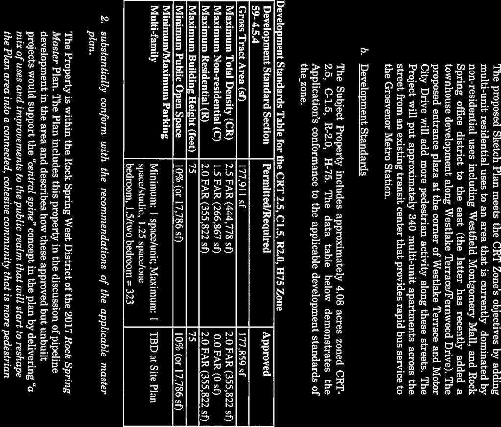
15 SECTION 4: ANALYSIS AND REQUIRED FINDINGS Section E.2, Necessary Findings, states that to approve a site plan, the Planning Board must find that the proposed development: a. Satisfies any previous approval that applies to the site; The previous Site Plan approval ( ) will be superseded by this Site Plan Amendment. The Subject Application satisfies Sketch Plan , approved by the Planning Board on November 20, The Site Plan Amendment implements the approved Sketch Plan by adhering to the binding elements for maximum density and height; approximate location of lots and public dedications; general location and extent of public open space; general location of vehicular access points, and public benefit schedule. b. Satisfies under Section B.5 the binding elements of any development plan or schematic development plan in effect on October 29, 2014; This finding is not applicable as this Property is not subject to a development plan or schematic development plan. c. Satisfies under Section B.5 any green area requirement in effect on October 29, 2014, for a property where the zoning classification on October 29, 2014 was the result of a Local Map Amendment; This finding is not applicable because the Property s zoning classification on October 29, 2014 was not the result of a Local Map Amendment. d. Satisfies applicable use standards, development standards, and general requirements under this chapter; i. Use and Development Standards The proposed multi-unit living use is permitted in the CRT-2.5 C-1.5 R-2.0 H-150 zone, and therefore has no use standards. As demonstrated in Table 1, the Project satisfies the development standards for the CRT Zone optional method of development. 15
16 Table 1: CRT Zone Optional Method Development Standards (Section B) Development Standard Permitted/ Required Proposed Tract Area n/a 177,911 sf (4.084 ac) Proposed Dedication- Westlake Terrace n/a 52 sf (0.001 ac) Site Area n/a 177,859 sf (4.083 ac) Density (max) Total Density 444,647/2.5 FAR 355,822 sf/2.0 FAR Residential Density 355,822 sf/2.0 FAR 355,822 sf/2.0 FAR Commercial Density 266,788/1.5 FAR n/a Building Height (max) 150 ft 75 ft Public Open Space (min) 10% (17,786 sf) 10% (17,786 sf) Minimum Setbacks Established at site plan 10 ft ii. Public Benefits As demonstrated in Table 3, the Project will provide at least 50 public benefit points in a minimum of three categories as required under Section A.2. The Rock Spring Master Plan recommends that all optional method projects in the master plan area should provide 15% MPDUs as the highest priority public amenity for new residential developments, unless the property is required to dedicate land for a school site or athletic fields that can be used by Montgomery County Public Schools (MCPS) and approximate the size of a local park. The Sketch Plan review was initiated long before the Council's PHED Committee added this recommendation to the Planning Board Draft and the County Council adopted the Master Plan. Therefore, this Project does not include 15% MPDUs as a public amenity to earn benefit points; nor does it dedicate land for a school or athletic field. At the time of Sketch Plan approval, the Planning Board agreed with the Applicant s assertion that this recommendation was added to the Draft Master Plan at a very late stage in the development review process (approximately one week before the publication of the Sketch Plan Staff Report), and that the Sketch Plan application had already gone through significant Staff review, including the Development Review Committee (DRC) without consideration of this eleventh-hour revision to the Draft Master Plan. Instead, the Planning 16
17 Board found that the Applicant was proposing appropriate amenities to help the Project achieve needed benefit points given the circumstances. Therefore, the Applicant is not required to provide 15% MPDUs, as substantial compliance has been achieved. Table 2: Public Benefit Points Max Points Points Allowed Requested Public Benefit Categories/Amenities A: Major Public Facilities Bikeshare Station B: Transit Proximity Level 2 Transit Proximity C: Connectivity and Mobility Minimum Parking D: Diversity of Uses and Activities Enhanced Accessibility E: Quality Building and Site Design Structured Parking F: Protection and Enhancement of the Natural Environment Cool Roof Vegetated Area TOTAL Recommended for Approval Major Public Facility Bikeshare Station: The Project includes a 19-dock bikeshare station and the Applicant is requesting five points, which is consistent with the amount granted for bikeshare stations approved with comparable projects. Transit Proximity The Property is located across Westlake Terrace from the Westfield Montgomery Mall Transit Center, a future stop for the master planned Bus Rapid Transit Corridor that will run along Westlake Terrace. The Zoning Ordinance classifies this type of stop as Level 2 transit proximity. In the CRT Zone, a Property that confronts a Level 2 transit stop may be granted 15 points, as requested by the Applicant. Connectivity and Mobility Minimum Parking: The Applicant is requesting points for providing fewer than the maximum allowed number of parking spaces. Points for this incentive are granted on a sliding scale up to a maximum of 10 points for providing no more than the minimum number of required parking spaces on-site. The minimum required number of on-site spaces is 323 and the Applicant is proposing 373 parking spaces. The Applicant is requesting 5 points in this subcategory as allowed using the calculation below from the Commercial/Residential and Employment Zones Incentive Density Implementation Guidelines (CR Guidelines). [423 (maximum allowed spaces)-373 (proposed spaces)] / [423 (maximum allowed spaces)-323(minimum spaces required) *10= 5 17
18 Diversity of Uses and Activities Enhanced Accessibility for Seniors or the Disabled: Seven of the proposed ground-level units will be constructed with interiors that satisfy American National Standards Institute A117.1 Residential Type A standards, or an equivalent County standard. The Applicant requests six points, consistent with the following formula in the CR Guidelines: 7(ANSI units) / (343 total units)*300 = 6.1 Quality Building and Site Design Structured Parking: The Applicant is proposing to include all off-street parking in an above-grade parking garage, which will be wrapped around on all sides with residential units. The Applicant is requesting 10 points in this subcategory, consistent with the CR Guideline formula: (373 (above grade spaces)/373 (total spaces)*10= 10 Protection and Enhancement of the Natural Environment Cool Roof: The Applicant requests five points for constructing any roof area (that is not covered by a vegetated roof) with a minimum solar reflectance index (SRI) of 75 for roofs with a slope at or below a ratio of 2:12, and a minimum SRI of 25 for slopes above 2:12. The C/R Guidelines indicate that five points are appropriate for development on sites greater than one acre. Vegetated Area: The Applicant proposes 10 points for the installation of plantings on the eastern portion of the site in a minimum of 12 inches of soil that covers 5,045 square feet. The C/R Guidelines indicate that 5 points are appropriate for a vegetated area that covers at least 5,000 square feet and does not include vegetated roofs or stormwater management facilities. iii. Parking Table 3: Parking Requirements (Division 6.2) Minimum Maximum Spaces Spaces Required Allowed Vehicle Parking (Reduced Parking Area) 1 Efficiency (38 market rate; 5 MPDUs 2 ) BR (157 market rate; 22 MPDUs) BR (106 market rate; 16 MPDUs) Total Vehicle Spaces Bicycle Parking 344 du 100 (95 long term) n/a Spaces Provided 102 long-term, 6 short-term Loading Spaces 1 n/a 1 1 Spaces for electric vehicles, car-share and motorcycles are provided as required in Section The Applicant is using a 0.5 adjustment factor for MPDUs as allowed under Section I. 18
19 iv. Open Space and Recreation The Project s 17,786 square feet designated as public open space (the urban plaza) adheres to the requirements of Division 6.3 (Open Space and Recreation). This area only contains allowed features and does not contain any prohibited improvements per Section of the Zoning Ordinance. Furthermore, the public open space abuts public sidewalks, includes areas for pedestrian circulation, landscaping, seating, shade, artwork and recreation, is in a contiguous space that abuts other public open space, sidewalks, or pedestrian routes, and is neither fragmented nor disconnected. The tabulations included in the Application also demonstrate compliance with recreation facility guidelines. Recreation facilities include an outdoor pool, a pedestrian connection/trail system, and a grilling area. e. Satisfies the applicable requirements of: i. Chapter 19, Erosion, Sediment Control, and Stormwater Management; and The Montgomery County Department of Permitting Services (MCDPS) Stormwater Management Section issued a letter dated April 10, 2018 to reconfirm approval of the Stormwater Management Concept Plan originally approved on August 9, ii. Chapter 22A, Forest Conservation Environmental Guidelines A Natural Resources Inventory/Forest Stand Delineation (NRI/FSD) was approved for this Property on October 1, The Property contains no streams or stream buffers, wetlands or wetland buffers, 100-year floodplains, hydraulically adjacent steep slopes, or known occurrences of Rare, Threatened, and Endangered species. This Site Plan Amendment is in conformance with the Montgomery County Planning Department s Environmental Guidelines. Forest Conservation This site has a previously approved Final Forest Conservation Plan (FFCP No ). The Property contains no forest, and no forest was cleared as a part of the original approval. The Net Tract area remains the same, as does the forest conservation mitigation requirement of 0.67 acres of forest planting. The Limits of Disturbance are being amended only slightly. No variance trees are being impacted. The Applicant proposes to satisfy the mitigation requirement through payment of a fee-in-lieu of planting. Because the original FFCP had approval to mitigate by payment of a fee-in-lieu, this remains acceptable for this amendment. The plan as submitted is in compliance with Chapter 22A, Forest Conservation. Noise The Applicant submitted a noise study indicating that a noise barrier and enhanced building materials will be needed to mitigate interior and exterior noise levels in impacted portions of the development. The Site Plan Amendment includes an eight-foot noise barrier along the eastern portion of the site as recommended by the noise study. The noise study indicates that a Building Shell Analysis will be performed to determine exact materials and ratings needed for construction. Enhanced building materials must be incorporated into the building materials to mitigate interior noise levels to meet the 45 bba Ldn standard. 19
20 f. Provides safe, well integrated parking, circulation patterns, building massing and, where required, open space and amenities; Parking and Circulation Patterns Vehicles will access the Project s above-grade structured parking facility via a dedicated entrance off of Motor City Drive near the signalized intersection at Westlake Terrace. The parking structure is designed to be shielded from view as it sits below the roofline and is entirely wrapped by the Project s residential uses. The Project incorporates a separate loading and service area, which is appropriately located in the rear of the Property and accessed via a drive aisle off of Motor City Drive in order to prevent any conflicts with resident and visitor traffic accessing the parking garage entrance. The Project accommodates proper circulation for fire and emergency vehicles. An existing traffic signal at the intersection of Westlake Terrace and Motor City Drive will facilitate vehicle movements to and from the Property and to Interstate 270. Enhanced landscaping, as well as the inclusion of a bikeshare station, will encourage pedestrian and cyclist activity. The Project s open spaces, including the entry plaza at the corner of Westlake Terrace and Motor City Drive and the leisure trail, as well as improved streetscaping along both street frontages will facilitate pedestrian and bicycle movement around the entire perimeter of the Property. Existing crosswalks with countdown pedestrian signals at the intersection of Westlake Terrace and Motor City Drive also promote safe circulation to the Transit Center, the Westfield Montgomery Mall, the nearby retail uses, and Cabin John Regional Park. Building Massing The building is designed with the entry plaza as a focal point for the development with chamfered corners framed by the Project s interior residential amenities. The building s incorporation of walkup units with ground floor entries and stoops along both Motor City Drive and Westlake Terrace promote street level activity and connections with surrounding development. Building facades are highly articulated and include balconies to provide visual interest along all street frontage. Open Space and Amenities The Project s public open space entry plaza is sited in a central location with art, trees, landscaping, benches, an open lawn area, and pathways to offer a welcoming gathering area and encourage connections to nearby uses. The open areas extend around the building s southern and eastern boundary to provide space for walking trails, swaths of plantings, picnic areas, seating areas with moveable furniture, and a game lawn to promote both active and passive recreation. Two contrasting courtyards will provide additional private amenity areas for residents: one with a lounge, grilling area, and swimming pool with deck that is open to the leisure trail, and the other enclosed with a terrace, plantings, and seating for quieter activities. g. Substantially conforms with the recommendation of the applicable master plan and any guidelines approved by the Planning Board that implement the applicable plan; The Property is within the Rock Spring West/Mixed-Use Regional Marketplace District of the 2017 Rock Spring Master Plan, and the proposed development satisfies one of the plans overarching goals to create opportunities for redevelopment of single-use commercial areas and surface parking lots with a mix of uses and public spaces (p 18). The Master Plan includes the Property in the discussion of pipeline development in the area and describes how these approved but unbuilt projects would support the central spine concept in the Master Plan by delivering a mix of uses and improvements 20
21 to the public realm that will start to reshape the Plan area into a connected, cohesive community that is more pedestrian and bicycle friendly for employees, residents, students, and visitors (pgs 16 and 17). The Applicant has incorporated the following applicable design guidance from the Rock Spring Master Plan in the proposed Site Plan: Buildings (p22) Concentrate development intensity along Westlake Drive and Westlake Terrace and proximate to the Transit Center on the West Side. To the extent possible, activate the frontage of Westlake Terrace. Implement quality building and site design considerations, such as building orientation to take advantage of passive heating, lighting, and ventilation. Prioritize consolidation of frontage along the central spine, and the introduction of residential uses to balance existing commercial uses. The proposed Project establishes a gateway into the Rock Spring district and begins the transformation of this area at a highly visible location along the Central Spine. The Project adds new housing along Westlake Terrace across the street from the Transit Center and provides a plaza and the main building entrance along Westlake Terrace that will activate this street. At the Sketch Plan stage, the Applicant conducted a solar study to demonstrate that the building orientation will maximize solar gain in the winter months and provide shade for the interior courtyards and the pool area in the summer. The Project will bring residential units to a predominantly commercial area directly across the street from the Transit Center and transform a former automobile dealership site into a block with urban street frontages and public and private open spaces. Connectivity and Open Space (p.23) - Improve the public realm along existing connections with wider sidewalks and landscaped areas to enhance pedestrian access between developing properties, the central spine, and adjacent communities. - Consolidate the areas designated for public open space as part of the development process into usable, substantial, active, programmed, and accessible spaces. The Project proposes a public plaza at the corner of Westlake Terrace and Motor City Drive, which will also act as the main pedestrian entrance to the building. This space will be an attractive addition to the network of sidewalks and other open spaces in the surrounding neighborhood. Further, the Project will improve the pedestrian experience along Westlake Terrace and Motor City Drive with landscaped areas and wider sidewalks. The proposed Project also improves an existing PEPCO easement along I-270 to provide a walking loop around the site that will connect to the network of public sidewalks in the area. The proposed development also satisfies several of the Master Plan s environmental and sustainability goals by increasing the tree canopy and reducing the amount of impervious surface on 21
22 a site that is almost completely covered with asphalt. The Project also offers opportunities to reduce reliance on single-occupant vehicles by locating housing close to a bus transit hub. h. Will be served by adequate public facilities including schools, police and fire protection, water, sanitary sewer, public roads, storm drainage, and other public facilities. If an approved adequate public facilities test is currently valid and the impact of the development is equal to or less than what was approved, a new adequate public facilities test is not required. If an adequate public facilities test is required, the Planning Board must find that the proposed development will be served by adequate services and facilities, including schools, police and fire protection, water, sanitary sewer, public roads, and storm drainage; The Resolution for the original site plan for this Property (No ), adopted by the Planning Board on October 15, 2009, found that there were adequate facilities to serve the proposed development. Although the resolution did not specify a specific expiration of the Adequate Public Facilities (APF) validity period, the minimum APF validity period at the time was seven years for any plan approved on or after April 1, 2009, but before April 1, After factoring in the 30-day appeal period, the Planning Board s APF finding as part of its Site Plan approval would have expired on November 15, Subsequent to the original APF approval, the County Council passed three separate automatic two-year extensions of all valid plans, adding another six years of validity to the original approval. Thus, the Planning Board s finding of APF made in the original Site Plan Resolution remains valid until November 15, Since the prior APF is still valid, the Subject Application is only evaluated based on the change in use proposed in this amendment the elimination of the commercial uses and the addition of four residential units. As discussed in detail below, the proposed Project falls within the Ashburton Elementary School service area, which is in moratorium. An additional three units would fall within the de minimis exemption; therefore, Staff recommends conditioning this approval to a maximum of 343 dwellings units rather than the requested 344 units. Schools Site plan application # for Ourisman Ford Montgomery Mall was approved with conditions by the Planning Board on September 17, 2009 for 340 multifamily high-rise units. The applicant remains entitled to those 340 units until the adequate public facilities ordinance validity period expires on November 15, The proposed amendment (# B) would increase the number of multifamily high-rise units to 344, for a net increase of four units. The amendment is scheduled for Planning Board review on September 6, 2018, therefore the applicable annual school test is the FY19 Annual School Test, approved by the Planning Board on June 21, 2018 and effective July 1, Cluster Service Area Status and Adequacy The project is located in the Walter Johnson High School (WJ) Cluster service area, which for FY19 is conditionally open for new residential development. The student enrollment and capacity projections from the FY19 Annual School Test for the WJ Cluster are noted in the following table: Projected Cluster Totals, September 2023 Moratorium Enrollment School Level Enrollment Program Capacity % Utilization Threshold Elementary 4,586 4, % 5,450 Middle 2,333 2, % 2,915 22
23 High 2, , % 2,797 The Moratorium Enrollment Threshold identified in the table is the enrollment at which the 120% utilization threshold is exceeded, resulting in a cluster-wide residential development moratorium. Current projections for the cluster fall within the threshold at each level, therefore the cluster service area remains open to new residential development. School Service Area Status and Adequacy The project is located within the North Bethesda MS and the Ashburton ES service areas. For FY19, the North Bethesda MS service area is open for new residential development; however, the Ashburton ES service area is under a residential development moratorium. As such, no development application or amendment that exceeds the de minimis threshold of three units can be approved within the Ashburton ES service area. Based on the FY19 Annual School Test results, the student enrollment and capacity projections for these schools are noted in the following table: Projected School Totals, September 2023 Moratorium Enrollment Thresholds School Enrollment Program Capacity % Utilization Surplus/ Deficit 120% Utilization Surplus/ Deficit Ashburton ES % No. Bethesda MS 1,188 1, % +41 1,475 1,409 Under the individual school adequacy test, a school is deemed inadequate if the projected school utilization rate exceeds 120% and if the school seat deficit meets or exceeds 110 seats for the elementary school or 180 seats for the middle school. If a school s projected enrollment exceeds both thresholds, then the school service area is placed in a residential development moratorium. The Moratorium Enrollment Thresholds identified in the table above are the enrollments at which the 120% utilization threshold and the seat deficit threshold are exceeded. The projected enrollment falls below both applicable moratorium thresholds for North Bethesda MS. The projected enrollment at Ashburton ES, however, exceeds both applicable moratorium thresholds, therefore the school s service area is under a residential development moratorium for FY19. Analysis Conclusion Due to the residential development moratorium currently in place on the Ashburton ES service area, the Planning Board cannot approve the applicant s proposed amendment. If the applicant, however, limits the amendment to a net of three additional dwelling units (bringing the project s total to 343 dwelling units), it can be approved under the moratorium s de minimis exemption, which allows approval of applications or amendments with a net effect of three units or less. 4 The projected cluster high school enrollment of 3,118 has been modified to reflect the estimated impact of a future boundary change that will reassign students from Walter Johnson HS to a reopened Charles W. Woodward HS prior to September
24 Transportation Master-Planned Roadways, Bikeway, and Transitway The master-planned transportation facilities are designated below in accordance with the following: 2017 Rock Spring Master Plan 2005 Countywide Bikeways Functional Master Plan Draft Bikeways Master Plan 2013 Countywide Transit Corridors Master Plan Westlake Terrace is designated as a business district street, B-3, in the Rock Spring Master Plan with a recommended 90-foot right-of-way. There is currently less than 45 feet from Westlake Terrace s centerline along one segment of the roadway where up to nine feet of additional right-of-way must be dedicated by a deed of dedication. The Rock Spring Master Plan and the draft Bikeways Master Plan recommend a separated bikeway with two-way bike lanes on the south side of Westlake Terrace. Westlake Terrace currently has striped bike lanes on both sides of the roadway that will remain in the interim until the bikeway is constructed on the south side of the road. The Countywide Transit Corridors Functional Master Plan recommends a Bus Rapid Transit route (Corridor 6 North Bethesda Transitway) that includes a segment along the Property s Westlake Terrace frontage, with a stop at the Transit Center across the street. The I-270 West Spur is designated as a freeway, F-1a, with a recommended 300-foot right-of-way. Motor City Drive is designated as a business district street with a 70-foot right-of-way in the Rock Spring Master Plan. Transit Service The following bus routes operate along the site frontage of Westlake Terrace and stop at the Montgomery Mall Transit Center located on the opposite side of Westlake Terrace: Ride-On route 6 operates between the Grosvenor Metrorail Station and the Montgomery Mall Transit Center with half-hour headways on weekdays only. Ride-On route 26 operates between the Glenmont Metrorail Station and the Montgomery Mall Transit Center with half-hour headways on weekdays and weekends. Ride-On route 42 operates between the White Flint Metrorail Station and the Montgomery Mall Transit Center with half-hour headways on weekdays and Saturdays. Ride-On route 47 operates between the Rockville Metrorail Station and the Bethesda Metrorail Station with half-hour headways on weekdays and weekends. Ride-On route 96 operates between the Grosvenor Metrorail Station and the Montgomery Mall Transit Center with half-hour headways on weekdays only. Metrobus routes J2 and J3 operate between the Silver Spring Metrorail Station/Paul Sarbanes Transit Center and the Montgomery Mall Transit Center with half-hour headways on weekdays and weekends. 24
25 Pedestrian and Bicycle Facilities The Applicant has proposed to upgrade the existing sidewalks along the Property s Motor City Drive frontage and the Westlake Terrace/Motor City Drive intersection including dual handicap ramps at the northeast corner of the intersection and other pedestrian improvements. The improvements are necessary to provide a safe pedestrian connection from the Property to Westfield Montgomery Mall and the Transit Center located on the opposite side of Westlake Terrace. The existing five to six-foot sidewalk along the retaining wall on Westlake Terrace will remain, but the sidewalk will be upgraded at the corner of the intersection with Motor City Drive. The Applicant is providing a 19-dock bikesharing station on the site in addition to six short-term inverted-u bike racks, or approved equivalent, and 102 long-term bicycle parking spaces in a bike room in the garage. Transportation Demand Management The Property is located within the western limits of the North Bethesda Transportation Management District (TMD). The Applicant must enter into a Traffic Mitigation Agreement with the Planning Board and MCDOT to participate in the North Bethesda Transportation Management District (TMD) in order to assist the County in achieving and maintaining the 41% non-auto-driver mode share for residential trips as recommended in the Rock Spring Master Plan. Adequate Public Facilities (APF) Test for Prior Site Plan Approval The 2009 Site Plan ( ) approval limited the development to 340 mid-rise apartment units and 50,869 square feet of general retail/restaurant uses under the Growth Policy. A traffic study was submitted with Site Plan No to satisfy the Local Area Transportation Review (LATR) test because the proposed land uses would generate 30 or more peak-hour vehicular trips within the weekday morning (6:30-9:30 am) and evening (4:00-7:00 pm) peak periods. Based on the results of the 2009 traffic study, the CLV values at all ten studied intersections were less than their congestion standard and, thus, the LATR test was satisfied. A Policy Area Mobility Review (PAMR) test was also required for the 2009 APF approval. To satisfy the PAMR test, the Applicant was required to mitigate new site-generated peak-hour trips within the weekday evening peak hours by providing pedestrian improvements at three intersections connecting the Transit Center at Montgomery Mall and the office buildings in Rock Spring Park (Table 4). Intersection Rockledge Drive & Rock Spring Drive Rockledge Drive-Marriott s Table 4: Intersection Improvements Required by 2009 APF PAMR Approval Dual Handicap Ramps 8 ramps at 2 of the 4 corners 8 ramps at 2 of the 4 corners Accessible Pedestrian Signal Pushbuttons At all 4 corners At all 4 corners Pedestrian Crosswalks & Stop Bars Pedestrian Countdown Signal Heads Trips Mitigated Not Needed Not Needed 32 On each intersection leg In the southeast corner 32 25
26 driveway & Fernwood Road Rock Spring Drive- Marriott s driveway & Fernwood Road 8 ramps at 2 of the 4 corners At all 4 corners Not Needed Not Needed 32 Trips Mitigated All of the handicap ramps were upgraded by the County. Accessible Pedestrian Signals (APS) were installed in 2014 at the intersection of Rockledge Drive- Marriott Driveway and Fernwood Road. At the intersection of Rockledge Drive & Rock Spring Drive and the intersection of Rock Spring Drive- Marriott s driveway & Fernwood Road, the County has APS improvements included in the Capital Improvements Program (CIP). 5 To satisfy the 2009 PAMR test, the Applicant must contribute to the CIP project, with the amount to be determined by MCDOT. LATR for Subject Application The proposed changes in land use will result in a net reduction in the number of peak-hour trips and, thus, a traffic study is not required to satisfy the LATR. Other Public Facilities The proposed development will be served by public water and sewer systems. Fire and Rescue has reviewed the application and has determined that the Property has appropriate access for fire and rescue vehicles. Other public facilities and services including police stations, firehouses and health care are currently operating in accordance with the Subdivision Staging Policy and will continue to be sufficient following the construction of the Project. Electric, gas and telecommunications services will also be available and adequate. i. On a property in a Rural Residential or Residential zone, is compatible with the character of the residential neighborhood; Not applicable, the Subject Property is zoned CRT. j. On a property in all other zones, is compatible with the existing and approved or pending adjacent development. The Project is compatible with existing and pending nearby development. The Project s building strongly defines the street edge and introduces urban inspired design on a highly visible corner in an area that is transitioning from an auto-centric built environment. A public open space plaza at the intersection of Westlake Terrace and Motor City Drive, the inclusion of ground level walk-up units with stoops and patios, the incorporation of significant landscaping along street frontages, and the Property s location directly across the street from the Transit Center all encourage increased pedestrian and cyclist activity around the Property. The Project s landscape design, which includes new green areas and open spaces for recreation and relaxation, effectively buffers the Property from Interstate 270 and takes advantage of the adjacent tree line. The Project s proposed building 5 CIP Project No , Traffic Signals Account Code 405/50522/
27 height of up to 75 feet is appropriate with nearby structures. The building type and use is also compatible with the anticipated redevelopment of the Westfield Montgomery Mall confronting the Property to the south. CONCLUSION Based on the review by Staff and the other relevant agencies, and the analysis contained in this report, Staff finds that the proposed Site Plan Amendment meets all the required findings and complies with the applicable Zoning Ordinance standards. Staff recommends approval of this Site Plan Amendment No B, subject to the conditions and findings contained herein. ATTACHMENTS 1. Site Plan Resolution 2. Sketch Plan No Resolution 3. Noise Study (Executive Summary) 4. Agency Letters 27
28 ATTACHMENT 1 OCT MONTGOMERY COUNTY PLANNING DEPARTMENT THE MARYLAND-NATIONAL CAPITAL PARK AND PLANNING COMMISSION MCPB No Site Plan No Project Name: Ourisman Ford at Montgomery Mall Date of Hearing: September 17, 2009 MONTGOMERY COUNTY PLANNING BOARD RESOLUTION WHEREAS, pursuant to Montgomery County Code Division , the Montgomery County Planning Board ("Planning Board") is vested with the authority to review site plan applications; and WHEREAS, on March 18, 2009, Withro Holdings, LLP/FP Westlake, LLC, ("Applicant") filed an application for approval of a site plan for a mixed-use development with 340 dwelling units, including 43 MPDUs (12.5%), 42,000 gross square feet of retail use, and 12,000 gross square feet of restaurant space, and a parking waiver for 118 parking spaces ("Site Plan" or "Plan") on 4.08 acres of C-2-zoned land, located in the northwest quadrant of the intersection of Motor City Drive and Westlake Terrace ("Property" or "Subject Property"); and WHEREAS, Applicant's site plan application was designated Site Plan No , Ourisman Ford at Montgomery Mall (the "Application"); and WHEREAS, Planning Board staff ("Staff') issued a memorandum to the Planning Board, dated September 7, 2009, setting forth its analysis of, and recommendation for approval of the Application subject to certain conditions ("Staff Report"); and WHEREAS, following review and analysis of the Application by Staff and the staff of other governmental agencies, on September 17, 2009, the Planning Board held a public hearing on the Application (the "Hearing"); and Approved as to Legal Sufficiency Georgia Avenue, Silver Spring, Maryland Director's Office: Fax: % recycled paper

29 MCPB No. Site Plan No Ourisman Ford at Montgomery Mall Page 2 WHEREAS, at the Hearing, the Planning Board heard testimony and received evidence submitted for the record on the Application; and WHEREAS, on September 17, 2009, the Planning Board approved the Application subject to conditions on the motion of Commissioner Wells-Harley; seconded by Commissioner Alfandre; with a vote of 3-0, Commissioners Alfandre, Hanson, and Wells-Harley voting in favor, and Commissioners Cryor and Presley being absent. NOW, THEREFORE, BE IT RESOLVED, that pursuant to the relevant provisions of Montgomery County Code Chapter 59, the Montgomery County Planning Board APPROVES Site Plan No for a mixed-use development with 340 dwelling units, including 43 MPDUs (12.5%), 42,000 gross square feet of retail use, and 12,000 gross square feet of restaurant space, and a parking waiver for 118 parking spaces, on 4.08 gross acres in the C-2 zone, subject to the following conditions: Environment 1. Forest Conservation a. The applicant must satisfy all conditions of the final forest conservation plan prior to Montgomery County Department of Permitting Services (MCDPS) issuance of sediment and erosion control permit(s), as appropriate. b. Submission of the final forest conservation plan consistent with Section 109.B. of the forest conservation regulations. Worksheet must be revised to include only native trees, and trees outside public rights of way for credits towards meeting forest conservation requirements. 2. Noise Mitiqation a. The applicant must investigate design options and propose noise mitigation measures that are consistent with the intent of the performance criteria identified in the "Conclusions" section of the Polysonics Corp. technical noise study entitled "Traffic Noise Testing - Ourisman Site - Montgomery Mall" dated June 11, Details showing noise appropriate site design and mitigation must be submitted for Environmental Planning and Development Review staff review and approval prior to certified site plan approval. b. Certification from an acoustical engineer that the building shell for residential dwelling units to be constructed within the projected 65 dba Ldn noise contour is designed to attenuate projected exterior noise levels to an interior level not to exceed 45 dba Ldn. The certification shall be provided to M-NCPPC Environmental Planning staff for concurrence prior to issuance of building permits. c. The builder shall provide a signed commitment to construct the impacted units in accord with the acoustical design specifications. Any changes to the

30 MCPB No. Site Plan No Ourisman Ford at Montgomery Mall Page 3 building shell construction that may affect acoustical performance after issuance of building permit shall be approved by an acoustical engineer and M-NCPPC Environmental Planning staff prior to their implementation. 3. Stormwater Manaqement The proposed development is subject to Stormwater Management Concept approval conditions dated January 26, 2009, unless amended and approved by the Montgomery County Department of Permitting Services. 4. LEED Certification The Applicant must achieve a LEED (Leadership in Energy and Environmental Design) Certified Rating Certification at a minimum. The Applicant must make good faith e.fforts to achieve a LEED Silver rating. Before the issuance of any use and occupancy certificate, the Applicant must inform M-NCPPC staff of the LEED Certification Level for which they are applying. If this level is less than a Silver rating, before the issuance of the final use and occupancy certificate the Applicant must provide to staff a written report, for public record purposes only, from the Applicant's LEED consultant analyzing the feasibility of achieving a LEED-Silver rating and identifying the minimum additional improvements required to achieve the LEED Silver rating, including their associated extra cost. Transportation & Circulation 5. Maximum Development The Applicant must limit the proposed mixed-use development to a maximum of 340 mid-rise apartments and 50,869 leasable square feet of general retail uses. 6. PAMR The Applicant must satisfy Policy Area Mobility Review (PAMR) by providing pedestrian safety ADA-compliant improvements at the signalized intersections of Rockledge Drive/Rock Spring Drive, Rock Spring Drive-Marriott's driveway/ Fernwood Road, and Rockledge Drive-Marriott's driveway/ Fernwood Road. The three intersections are along the walking route that connects the Westfield Montgomery Mall and its Transit Center with the office buildings in the adjacent Rock Spring Park. At each corner of the three intersections, ADA-compliant dual handicapped ramps and accessible pedestrian signals must be installed. At Rockledge Drive-Marriott's driveway/fernwood Road only, the pedestrian crosswalks and stop bars need to be upgraded at each intersection approach. In addition, a countdown pedestrian signal head is needed at the southeast corner. The pedestrian safety improvements must be permitted and bonded by the Montgomery County Department of Permitting Services (DPS) prior to release of any building permit.
31 MCPB No. Site Plan No Ourisman Ford at Montgomery Mall Page 4 7. Traffic Mitiqation Aqreement The Applicant must enter into a Traffic Mitigation Agreement with the Planning Board and the Montgomery County Department of Transportation (MCDOT) to participate in the North Bethesda Transportation Management District (TMD) and assist in achieving and maintaining its non-auto driver mode share goals. By Certified Site Plan, the Applicant must submit for staff review a draft Traffic Mitigation Agreement. The Traffic Mitigation Agreement must be fully executed prior to release of any building permit. 8. Pedestrian Improvements The Applicant must provide ADA-compliant dual handicapped ramps and accessible pedestrian signals at each corner of the two signalized intersections of Westlake Terrace with Motor City Drive. The pedestrian safety improvements must be permitted and bonded by DPS prior to release of any building permit. 9. Bicvcle Storaqe The Applicant must provide twenty (20) inverted-u bike racks along the site's frontage and ten (10) bike lockers in the garage within 50 feet of the elevator to serve the residents and visitors of the apartment building. Transportation Planning staff will determine the ultimate locations of the bike racks and lockers prior to site plan certification. Site Plan 10. Site Desiqn The exterior architectural character, proportion, materials, and articulation must be substantially similar to the schematic elevations shown on Sheet A A of the submitted architectural drawings, as determined by M-NCPPC Development Review and Urban Design staff. 11. Liqhtinq a. The lighting distribution and photometric plan with summary report and tabulations must conform to IESNA standards for mixed-use development. b. All onsite down- light fixtures must be full cut-off fixtures. c. Deflectors shall be installed on all fixtures causing potential glare or excess illumination, specifically on the perimeter fixtures abutting the adjacent residential properties. d. The height of the light poles shall not exceed the height specified in the certified site plan, including the mounting base.
32 MCPB No. Site Plan No Ourisman Ford at Montgomery Mall Page Landscape Surety The Applicant shall provide a surety (letter of credit, performance bond) in accordance with Section 59-D-3.5(d) of the Montgomery County Zoning Ordinance with the following provisions: a. The amount of the surety shall include plant material, on-site lighting, recreational facilities, and site furniture within the relevant block of development. Surety to be posted prior to issuance of first building permit within each relevant block of development and shall be tied to the development program. b. Provide a cost estimate of the materials and facilities, which will establish the initial bond amount. c. Completion of plantings by block, to be followed by inspection and bond reduction. Inspection approval starts the 1 year maintenance period and bond release occurs at the expiration of the one year maintenance period. d. Provide a screening/landscape amenities agreement that outlines the responsibilities of the respective parties and incorporates the cost estimate. Agreement to be executed prior to issuance of the first building permit. 13. Development Proqram The Applicant must construct the proposed development in accordance with a development program that will be reviewed and approved prior to the approval of the Certified Site Plan. The development program must include the following items in its phasing schedule: a. Street lamps and sidewalks must be installed as construction is completed. Street tree planting may wait until the next growing season. b. On-site amenities including, but not limited to, sidewalks, benches, trash receptacles, and bicycle facilities must be installed prior to release of any residential building occupancy permit. c. Clearing and grading must correspond to the construction phasing to minimize soil erosion and must not occur prior to approval of the Final Forest Conservation Plan, Sediment Control Plan, and M-NCPPC inspection and approval of all tree-save areas and protection devices. d. The development program must provide phasing of stormwater management, sediment and erosion control, afforestation, trip mitigation, and other features. 14. Certified Site Plan Prior to approval of the Certified Site Plan the following revisions must be made and/or information provided subject to Staff review and approval: a. Include the final forest conservation approval, stormwater management concept approval, development program, inspection schedule, and site plan resolution on the approval or cover sheet.

33 MCPB No. Site Plan No Ourisman Ford at Montgomery Mall Page 6 b. Add a note to the site plan stating that "M-NCPPC staff must inspect all treesave areas and protection devices prior to clearing and grading". c. Add a note that "All plant substitutions must be approved by M-NCPPC" and provide a list of alternative species. d. Modify data table to reflect development standards enumerated in the staff report. e. Ensure consistency off all details and layout between site plan and landscape plan. f. Minor changes to landscape, lighting, and recreation facilities. g. Final location, design, and details of any noise walls on-site. h. Provide a drawing elevation for the surface adjoining the recreational putting green on the east; show landscaping and planting. I. Show noise attenuation for the exterior recreational spaces, including the pool area. J. Provide fac;ade design for roof top mechanical equipment and/or mechanical penthouse( s). k. Provide a drawing showing line-of-sight visibility of roof top equipment and lighting standards, & signage (from public streets and and ramps). I. Demonstrate compliance with MCFRS requirements. BE IT FURTHER RESOLVED, that all site development elements as shown on Ourisman Ford at Montgomery Mall drawings stamped by the M-NCPPC on August 20, 2009, shall be required, except as modified by the above conditions of approval; and BE IT FURTHER RESOLVED, that having given full consideration to the recommendations and findings of its Staff as set forth in the Staff Report, which the Planning Board hereby adopts and incorporates by reference, and upon consideration of the entire record, the Montgomery County Planning Board FINDS, with the conditions of approval, that: 1. The Site Plan conforms to all non-illustrative elements of a development plan or diagrammatic plan, and all binding elements of a schematic development plan, certified by the Hearing Examiner under Section , or is consistent with an approved project plan for the optional method of development if required, unless the Planning Board expressly modifies any element of the project plan. Neither a development plan, diagrammatic plan, schematic development plan, nor a project plan were required for the subject site. 2. The Site Plan meets all of the requirements of the C-2 zone and where applicable conforms to an urban renewal plan approved under Chapter 56.
34 MCPB No. Site Plan No Ourisman Ford at Montgomery Mall Page 7 The proposed use is allowed in the C-2 Zone and the site plan fulfills the purposes of the zone by providing a mix of residential and commercial uses convenient to a Metro Bus Station to be developed on the adjacent Montgomery Mall site. As the project data table on page 12 indicates, the site plan meets all of the development standards of the zone. With respect to building height, setbacks, green space, and density the proposed development is under all the maximum standards allowed. Sections of the C-2 zone (59-C-4.35), including the purpose clause, allowed uses (e.g. dwelling units), and building height provisions, were invalidated by a recent court case but were not formally removed from the code by the County Council. There remains some ambiguity as to which standards apply, particularly to building height (i.e., 65' for 75'). Staff is prepared to recommend a maximum building height for this project of 75', but subsequent action by the County Council, or possibly other body, may be incompatible with this approach. Staff is pursuing corrective/clarifying action parallel to this review. The requested partial waiver of the total number of parking spaces required by the Zone, reducing the on-site parking from 763 spaces to 645 spaces, is consistent with the intent of providing transit-oriented housing and commercial uses. Requirements of the C-2 zone The Staff Report contains a data table that lists the Zoning Ordinance required development standards and the developments standards proposed for approval. The Board finds, based on the aforementioned data table, and other [uncontested] evidence and testimony of record, that the Application meets all of the applicable requirements of the C-2 Zone. The following data table sets forth the development standards approved by the Planning Board and binding on the Applicant. Data Table Development Standards Approved by the Board and Binding on the Applicant Gross Tract Area (acres) Gross Tract Area (square feet) Building Height (feet) ,911 75
35 MCPB No. Site Plan No Ourisman Ford at Montgomery Mall Page 8 Building Setbacks Motor City Drive Westlake Terrace North side East side (feet) Green Area (% of lot) Floor Area Ratio (FAR) Building Area (square feet) Max. Commercial Density (FAR) Max. Commercial Density (square feet) total Max. Retail Density (square feet) Max. Restaurant Density (square feet) Dwelling units MPDUs (%) , ,000 42,000 12, (43 du) Parking Spaces The locations of the buildings and structures, the open spaces, landscaping, recreation facilities, and pedestrian and vehicular circulation systems are adequate, safe, and efficient. a. Buildings and Structures The buildings and structures of the proposed development are located along the street, setting the correct standard for definition and activation of the public street as this area redevelops. The location provides easy access to the building from adjoining sidewalks and parking. Staff finds the locations of the buildings and structures to be adequate and efficient, while meeting the aesthetic concerns of the area, and not to pose safety concerns on the site. b. Open Spaces, Landscaping, and Recreation Facilities The central open space, the internal retail street accessible to the public, provides a well-designed pedestrian environment with opportunities for multiple activities. This area provides attractive streetscape, landscape,

36 MCPB No. Site Plan No Ourisman Ford at Montgomery Mall Page 9 and lighting. A secondary open space sequence, accessible only to residents, provides a variety of recreational facilities, including an outdoor pool, to complement indoor exercise and meeting spaces. The plan further includes and maintains a landscaped buffer along the busy adjacent roads, Interstate 270 and the Westlake Terrace overpass, to improve screening for residents. The open spaces, landscaping, and recreation facilities are adequate, safe, and efficient. c. Vehicular and Pedestrian Circulation Pedestrian access from adjacent sidewalks adequately and efficiently integrates this site into the surrounding area. The vehicular circulation design efficiently directs traffic into the site with minimal impacts to pedestrian circulation. The pedestrian and vehicular circulation systems are adequate, safe, and efficient. 4. Each structure and use is compatible with other uses and other site plans and with existing and proposed adjacent development. The proposed development sets a high standard for urban design in the redevelopment of this area. It faces the streets, opens to the sidewalks, and provides activating uses. This area is currently dominated by automobile-oriented uses and the proposed development is a strong beginning for its reorientation to transit-oriented pedestrian-friendly development. The structure itself is in scale with nearby redevelopment and is located such that it will not adversely impact existing or proposed adjacent uses. The proposed structure and uses are compatible with the surrounding existing, proposed, and planned uses and development. 5. The Site Plan meets all applicable requirements of Chapter 22A regarding forest conservation, Chapter 19 regarding water resource protection, and any other applicable law. A final forest conservation plan (FFCP) date stamped received by the Environmental Planning Division on March 18, 2009, has been submitted for approval. The plan shows no existing forest and/or specimen and champion trees on-site. The FFCP shows the site's forest conservation requirement of 0.67 acres to be met partially with afforestation tree planting credit of 0.29 acres and the remaining 0.38 acres by in-lieu payment. County DPS has issued concept stormwater management plan approval on January 26, The proposed method includes on-site detention and required
37 MCPB No. Site Plan No Ourisman Ford at Montgomery Mall Page 10 review of the landscape plan as part of the Sediment Control/Stormwater Management Plan. BE IT FURTHER RESOLVED, that this resolution constitutes the written opinion of the Planning Board in this matter and incorporates by reference all evidence of record, including maps, drawings, memoranda, correspondence, and other information; and BE IT FURTHER RESOLVED, that this Site Plan shall remain valid as provided in Montgomery County Code 59-D-3.8; and I""".. BE'5 IT " record); and FURTHER RESOLVED, that the date of this resolution is (which is the date that this resolution is mailed to all parties of BE IT FURTHER RESOLVED, that any party authorized by law to take an administrative appeal must initiate such an appeal within thirty days of the date of this Resolution, consistent with the procedural rules for the judicial review of administrative agency decisions in Circuit Court (Rule 7-203, Maryland Rules). * * * * * * * * * * * CERTIFICATION This is to certify that the foregoing is a true and correct copy of a resolution adopted by the Montgomery County Planning Board of The Maryland-National Capital Park and Planning Commission on motion of Commissioner Wells-Harley, seconded by Commissioner Hanson, with Commissioners Hanson, Presley, and Wells-Harley voting in favor of the motion, and with Commissioner Alfandre recused and Commissioner Cryor absent, at its regular meeting held on Thursday, October 1, 2009, in Silver Spring, Maryland.


38 ATTACHMENT 2
39
40

41
42
43

44
45


46

47

48
49 ATTACHMENT 3

50
MONTGOMERY COUNTY PLANNING DEPARTMENT
 MONTGOMERY COUNTY PLANNING DEPARTMENT THE MARYLAND-NATIONAL CAPITAL PARK AND PLANNING COMMISSION Ourisman Ford at Montgomery Mall, Sketch Plan No. 320170100 MCPB Item No. Date: 11-30-17 LS Lori Shirley,
MONTGOMERY COUNTY PLANNING DEPARTMENT THE MARYLAND-NATIONAL CAPITAL PARK AND PLANNING COMMISSION
 MONTGOMERY COUNTY PLANNING DEPARTMENT THE MARYLAND-NATIONAL CAPITAL PARK AND PLANNING COMMISSION MCPB Item No. Date: 12-10-15 Leisure World Clubhouse II Addition Fitness Center, Limited Site Plan Amendment
JUSTIFICATION STATEMENT FOR SKETCH PLAN NO Sketch Plan Justification for Ourisman Ford
 I. INTRODUCTION JUSTIFICATION STATEMENT FOR SKETCH PLAN NO. 320170100 Sketch Plan Justification for Ourisman Ford Owner and Applicant, FP Whitro Westlake, LLC ( Applicant ), by its attorneys, Linowes and
MONTGOMERY COUNTY PLANNING DEPARTMENT THE MARYLAND-NATIONAL CAPITAL PARK AND PLANNING COMMISSION
 MONTGOMERY COUNTY PLANNING DEPARTMENT THE MARYLAND-NATIONAL CAPITAL PARK AND PLANNING COMMISSION MCPB Item No. Date: 3.10.2016 Site Plan 820160040 Nora School Parker Smith, Planning Technician, Area 1,
MONTGOMERY COUNTY PLANNING DEPARTMENT
 MONTGOMERY COUNTY PLANNING DEPARTMENT THE MARYLAND-NATIONAL CAPITAL PARK AND PLANNING COMMISSION MCPB Item No.: Date: 5-03-18 Pike and Rose, Phase I: Site Plan Amendment No. 82012002D Rhoda Hersson-Ringskog,
MONTGOMERY COUNTY PLANNING DEPARTMENT THE MARYLAND-NATIONAL CAPITAL PARK AND PLANNING COMMISSION
 MONTGOMERY COUNTY PLANNING DEPARTMENT THE MARYLAND-NATIONAL CAPITAL PARK AND PLANNING COMMISSION MCPB Item No. Date: 1/26/12 Hanover Shady Grove, Sketch Plan 320120020 Joshua Sloan, Coordinator, Joshua.Sloan@MontgomeryPlanning.org,
MONTGOMERY COUNTY PLANNING DEPARTMENT Newell Street. Site Plan Item #2. Maryland-National Capital Park and Planning Commission
 8001 Newell Street Site Plan 820140020 Item #2 December 19, 2013 Redlined Conditions 1. The Applicant must comply with the conditions of approval for Project Plan 920130020 in MCPB Resolution No. 13-74.
The subject site plan amendment proposes the following revisions to the approved site plan:
 PROPOSED AMENDMENT The subject site plan amendment proposes the following revisions to the approved site plan: 1. The building footprint was modified to accommodate the revised architectural design. 2.
MONTGOMERY COUNTY PLANNING DEPARTMENT
 MONTGOMERY COUNTY PLANNING DEPARTMENT THE MARYLAND-NATIONAL CAPITAL PARK AND PLANNING COMMISSION MCPB Consent Date: 4-26-18 Cabin John Auto Park (N. Bethesda Home Depot), Site Plan Amendment No. 81980017A
MONTGOMERY COUNTY PLANNING DEPARTMENT
 MONTGOMERY COUNTY PLANNING DEPARTMENT THE MARYLAND-NATIONAL CAPITAL PARK AND PLANNING COMMISSION Ashburton Elementary School Addition, Mandatory Referral, MR2018009 MCPB Item No. Date: 02-15-18 Troy Leftwich,
MONTGOMERY COUNTY PLANNING DEPARTMENT THE MARYLAND-NATIONAL CAPITAL PARK AND PLANNING COMMISSION
 MONTGOMERY COUNTY PLANNING DEPARTMENT THE MARYLAND-NATIONAL CAPITAL PARK AND PLANNING COMMISSION The Goddard School in North Bethesda Preliminary Plan Amendment 11996015B and Site Plan Amendment 82006005A
MONTGOMERY COUNTY PLANNING DEPARTMENT THE MARYLAND-NATIONAL CAPITAL PARK AND PLANNING COMMISSION
 MONTGOMERY COUNTY PLANNING DEPARTMENT THE MARYLAND-NATIONAL CAPITAL PARK AND PLANNING COMMISSION MCPB Item No. Date: 06-12-14 King of the Nations Christian Fellowship Church: Limited Site Plan Amendment
MONTGOMERY COUNTY PLANNING DEPARTMENT THE MARYLAND-NATIONAL CAPITAL PARK AND PLANNING COMMISSION
 MONTGOMERY COUNTY PLANNING DEPARTMENT THE MARYLAND-NATIONAL CAPITAL PARK AND PLANNING COMMISSION MCPB Item No.: 2 Date: 12-19-13 Site Plan 820140020, 8001 Newell Street Neil Braunstein, AICP, Area 1, neil.braunstein@montgomeryplanning.org,
MONTGOMERY COUNTY PLANNING DEPARTMENT THE MARYLAND-NATIONAL CAPITAL PARK AND PLANNING COMMISSION MCPB Item No.: 13 Date: 07/19/18
 MONTGOMERY COUNTY PLANNING DEPARTMENT THE MARYLAND-NATIONAL CAPITAL PARK AND PLANNING COMMISSION MCPB Item No.: 13 Date: 07/19/18 Black Hill / ViaSat: Project Plan No. 92012004B, Preliminary Plan No. 12012021B,
MONTGOMERY COUNTY PLANNING DEPARTMENT THE MARYLAND-NATIONAL CAPITAL PARK AND PLANNING COMMISSION
 MONTGOMERY COUNTY PLANNING DEPARTMENT THE MARYLAND-NATIONAL CAPITAL PARK AND PLANNING COMMISSION Montgomery Auto Sales Park: Preliminary Plan No. 11985027A, Site Plan No. 820140130 and Site Plan No. 820140140
MONTGOMERY COUNTY PLANNING DEPARTMENT THE MARYLAND-NATIONAL CAPITAL PARK AND PLANNING COMMISSION
 MONTGOMERY COUNTY PLANNING DEPARTMENT THE MARYLAND-NATIONAL CAPITAL PARK AND PLANNING COMMISSION MCPB Item No. Date10/25/12 Sketch Plan No. 32012004, White Flint Mall Redevelopment Nkosi Yearwood, Senior
MONTGOMERY COUNTY PLANNING DEPARTMENT THE MARYLAND-NATIONAL CAPITAL PARK AND PLANNING COMMISSION
 MONTGOMERY COUNTY PLANNING DEPARTMENT THE MARYLAND-NATIONAL CAPITAL PARK AND PLANNING COMMISSION MCPB Item No. Date: 07-17-2014 Rock Spring Park, Preliminary Plan Amendment 11998093B and Site Plan Amendment,
MONTGOMERY COUNTY PLANNING DEPARTMENT THE MARYLAND-NATIONAL CAPITAL PARK AND PLANNING COMMISSION
 MONTGOMERY COUNTY PLANNING DEPARTMENT THE MARYLAND-NATIONAL CAPITAL PARK AND PLANNING COMMISSION MCPB Item No. Date: 05-22-14 Consent Item - Park Potomac: Site Plan Amendment No. 82004015K MCS. Molline
Rock Spring Master Plan Community Meeting #8: Preliminary Recommendations
 Rock Spring Master Plan Community Meeting #8: Preliminary Recommendations July 18, 2016 Ι Walter Johnson High School Andrea Gilles, andrea.gilles@montgomeryplanning.org Ι www.montgomeryplanning.org/community/rockspring/
MONTGOMERY COUNTY PLANNING DEPARTMENT THE MARYLAND-NATIONAL CAPITAL PARK AND PLANNING COMMISSION
 MONTGOMERY COUNTY PLANNING DEPARTMENT THE MARYLAND-NATIONAL CAPITAL PARK AND PLANNING COMMISSION MCPB Item No. 8 Date: 12-15-16 Montgomery Village Center Sketch Plan No. 320170020 TL Troy Leftwich, Senior
MONTGOMERY COUNTY PLANNING DEPARTMENT
 MONTGOMERY COUNTY PLANNING DEPARTMENT THE MARYLAND-NATIONAL CAPITAL PARK AND PLANNING COMMISSION North Bethesda Town Center Parcel G Site Plan No. 820180010 MCPB Item No.: Date: 01-25-18 Atul Sharma, Planner
MONTGOMERY COUNTY PLANNING DEPARTMENT
 MONTGOMERY COUNTY PLANNING DEPARTMENT THE MARYLAND-NATIONAL CAPITAL PARK AND PLANNING COMMISSION 6000 Executive Boulevard, Sketch Plan No. 320180140 MCPB Item No. Date: 06/21/2018 Emily Tettelbaum, Senior
MONTGOMERY COUNTY PLANNING DEPARTMENT
 MONTGOMERY COUNTY PLANNING DEPARTMENT THE MARYLAND-NATIONAL CAPITAL PARK AND PLANNING COMMISSION MCPB Item No. 4 Date: 12-15-16 CVS Derwood: Site Plan No. 820160150 Calvin Nelson, Jr., Planner Coordinator,
MONTGOMERY COUNTY PLANNING DEPARTMENT THE MARYLAND-NATIONAL CAPITAL PARK AND PLANNING COMMISSION
 MONTGOMERY COUNTY PLANNING DEPARTMENT THE MARYLAND-NATIONAL CAPITAL PARK AND PLANNING COMMISSION MCPB Item No. Date: 05/12/2016 North Bethesda Conference Center Parking Structure, Mandatory Referral No.
MONTGOMERY COUNTY PLANNING DEPARTMENT THE MARYLAND NATIONAL CAPITAL PARK AND PLANNING COMMISSION
 MONTGOMERY COUNTY PLANNING DEPARTMENT THE MARYLAND NATIONAL CAPITAL PARK AND PLANNING COMMISSION MCPB Item No. 3 Date: 1.5.17 7272 Wisconsin Avenue: Sketch Plan Amendment No. 32016004A, Preliminary Plan
MONTGOMERY COUNTY PLANNING DEPARTMENT THE MARYLAND-NATIONAL CAPITAL PARK AND PLANNING COMMISSION
 MONTGOMERY COUNTY PLANNING DEPARTMENT THE MARYLAND-NATIONAL CAPITAL PARK AND PLANNING COMMISSION MCPB Item No. Date: 1/15/2015 Bethesda North Marriott Hotel and Conference Center: Limited Site Plan Amendment
Clarksburg Square Road Extension
 Clarksburg Square Road Extension Preliminary Plan No. 120140060 Site Plan No. 820140050 Site Plan Amendment No. 82007022C (Clarksburg Town Center) Clarksburg SPA Water Quality Plan Mandatory Referral MR2015008
MONTGOMERY COUNTY PLANNING DEPARTMENT THE MARYLAND-NATIONAL CAPITAL PARK AND PLANNING COMMISSION
 MONTGOMERY COUNTY PLANNING DEPARTMENT THE MARYLAND-NATIONAL CAPITAL PARK AND PLANNING COMMISSION MCPB Item No. 3 4/3/14 4990 Fairmont Avenue, Site Plan 820140060 Erin Banks, AICP, Senior Planner, Area
MONTGOMERY COUNTY PLANNING DEPARTMENT THE MARYLAND NATIONAL CAPITAL PARK AND PLANNING COMMISSION
 MONTGOMERY COUNTY PLANNING DEPARTMENT THE MARYLAND NATIONAL CAPITAL PARK AND PLANNING COMMISSION MCPB Item No. 7 Date: 7.19.18 ZOM Bethesda, Preliminary Plan No. 120180140 and Site Plan No. 820180120 Matthew
MONTGOMERY COUNTY PLANNING DEPARTMENT THE MARYLAND-NATIONAL CAPITAL PARK AND PLANNING COMMISSION
 MONTGOMERY COUNTY PLANNING DEPARTMENT THE MARYLAND-NATIONAL CAPITAL PARK AND PLANNING COMMISSION Gables White Flint, Preliminary Plan No. 120150010 and Site Plan No. 820150010 MCPB Item No. Date: 4/30/2015
MONTGOMERY COUNTY PLANNING DEPARTMENT THE MARYLAND-NATIONAL CAPITAL PARK AND PLANNING COMMISSION
 MONTGOMERY COUNTY PLANNING DEPARTMENT THE MARYLAND-NATIONAL CAPITAL PARK AND PLANNING COMMISSION MCPB Item No. 4 7/18/13 4990 Fairmont Avenue, Project Plan 920130070 & Preliminary Plan 120130230 Erin Grayson,
MONTGOMERY COUNTY PLANNING DEPARTMENT THE MARYLAND-NATIONAL CAPITAL PARK AND PLANNING COMMISSION
 MONTGOMERY COUNTY PLANNING DEPARTMENT THE MARYLAND-NATIONAL CAPITAL PARK AND PLANNING COMMISSION MCPB Item No. Date: 9/22/16 Ripley II: Sketch Plan Amendment No. 32015003A, Preliminary Plan No. 120160190,
MONTGOMERY COUNTY PLANNING DEPARTMENT THE MARYLAND-NATIONAL CAPITAL PARK AND PLANNING COMMISSION
 MONTGOMERY COUNTY PLANNING DEPARTMENT THE MARYLAND-NATIONAL CAPITAL PARK AND PLANNING COMMISSION MCPB Item No. Date: 10.25.18 Artery Plaza: Site Plan Amendment 81984002E SD Stephanie Dickel, Planner Coordinator,
REQUEST Current Zoning: O-15(CD) (office) Proposed Zoning: TOD-M(CD) (transit oriented development mixed-use, conditional)
 (office) Proposed Zoning: TOD-M(CD) (transit oriented development mixed-use, conditional)") Rezoning Petition 2016-117 Zoning Committee Recommendation January 4, 2017 REQUEST Current Zoning: O-15(CD) (office) Proposed Zoning: TOD-M(CD) (transit oriented development mixed-use, conditional) LOCATION
Rezoning Petition 2016-117 Zoning Committee Recommendation January 4, 2017 REQUEST Current Zoning: O-15(CD) (office) Proposed Zoning: TOD-M(CD) (transit oriented development mixed-use, conditional) LOCATION
MONTGOMERY COUNTY PLANNING DEPARTMENT THE MARYLAND-NATIONAL CAPITAL PARK AND PLANNING COMMISSION
 MONTGOMERY COUNTY PLANNING DEPARTMENT THE MARYLAND-NATIONAL CAPITAL PARK AND PLANNING COMMISSION MCPB Item No. Date: 04/24/2014 Sketch Plan No. 320140020, AVA Wheaton Michael Brown, Planner Coordinator,
MONTGOMERY COUNTY PLANNING DEPARTMENT
 MONTGOMERY COUNTY PLANNING DEPARTMENT THE MARYLAND-NATIONAL CAPITAL PARK AND PLANNING COMMISSION MCPB Item No. 5 Date: 11.29.2018 The Crescent at Chevy Chase, Preliminary Plan No. 120180150 and Site Plan
MONTGOMERY COUNTY PLANNING DEPARTMENT
 MONTGOMERY COUNTY PLANNING DEPARTMENT THE MARYLAND-NATIONAL CAPITAL PARK AND PLANNING COMMISSION MCPB Item No. Date: 04/05/2018 850 Sligo Avenue Sketch Plan No. 320180090 Neil Sullivan, Planner Coordinator,
I. Introduction. Prior Approvals
 Statement of Justification First National Bank 19790 Crystal Rock Drive, Germantown, Maryland Application for Site Plan and Limited Preliminary Plan Amendment I. Introduction DPH Architecture, for First
MONTGOMERY COUNTY PLANNING DEPARTMENT THE MARYLAND-NATIONAL CAPITAL PARK AND PLANNING COMMISSION
 MONTGOMERY COUNTY PLANNING DEPARTMENT THE MARYLAND-NATIONAL CAPITAL PARK AND PLANNING COMMISSION 8015 Old Georgetown Road, Preliminary Plan 120160220, Site Plan 820160090 MCPB Item No.: 8 Date: 11-03-16
MONTGOMERY COUNTY PLANNING DEPARTMENT THE MARYLAND-NATIONAL CAPITAL PARK AND PLANNING COMMISSION
 MONTGOMERY COUNTY PLANNING DEPARTMENT THE MARYLAND-NATIONAL CAPITAL PARK AND PLANNING COMMISSION Staff Report: Sketch Plan #320110010, Mid-Pike Plaza ITEM #: MCPB HEARING DATE: January 20, 2011 REPORT
DRAFT Northeast Quadrant of Kipling Avenue and Highway 7 DRAFT AUGUST 29, Goals Land Use. The goals of this Plan are to:
 AUGUST 29, 2017 12.15 Northeast Quadrant of Kipling Avenue and Highway 7 12.15.1 Goals 12.15.2 Land Use The goals of this Plan are to: 12.15.2.1 General Provisions: a) Ensure the development of a compact
MONTGOMERY COUNTY PLANNING DEPARTMENT THE MARYLAND-NATIONAL CAPITAL PARK AND PLANNING COMMISSION
 MONTGOMERY COUNTY PLANNING DEPARTMENT THE MARYLAND-NATIONAL CAPITAL PARK AND PLANNING COMMISSION Preliminary Plan 120120220 & Site Plan 820120140, 7001 Arlington Road MCPB Item No. 8 Date: 11-1-12 Erin
MONTGOMERY COUNTY PLANNING DEPARTMENT THE MARYLAND-NATIONAL CAPITAL PARK AND PLANNING COMMISSION
 MONTGOMERY COUNTY PLANNING DEPARTMENT THE MARYLAND-NATIONAL CAPITAL PARK AND PLANNING COMMISSION MCPB Item No. Date: 9-4-13 Limited Site Plan Amendment No. 81994026B, Darcars at Montgomery Industrial Park,
FORMER CANADIAN FORCES BASE (CFB) ROCKCLIFFE SECONDARY PLAN. Official Plan Amendment XX to the Official Plan for the City of Ottawa
 ROCKCLIFFE SECONDARY PLAN. Official Plan Amendment XX to the Official Plan for the City of Ottawa") FORMER CANADIAN FORCES BASE (CFB) ROCKCLIFFE SECONDARY PLAN Official Plan Amendment XX to the Official Plan for the City of Ottawa 1 INDEX THE STATEMENT OF COMPONENTS PART A THE PREAMBLE PAGE Purpose...
FORMER CANADIAN FORCES BASE (CFB) ROCKCLIFFE SECONDARY PLAN Official Plan Amendment XX to the Official Plan for the City of Ottawa 1 INDEX THE STATEMENT OF COMPONENTS PART A THE PREAMBLE PAGE Purpose...
Gold Line Bus Rapid Transit Transit Oriented Development (BRTOD) Helmo Station Area Plan
 Helmo Station Area Plan") Appendix F Gold Line Bus Rapid Transit Transit Oriented Development (BRTOD) Helmo Station Area Plan Introduction and Purpose of the Plan The Gold Line Bus Rapid Transit facility is an eleven-mile dedicated
Appendix F Gold Line Bus Rapid Transit Transit Oriented Development (BRTOD) Helmo Station Area Plan Introduction and Purpose of the Plan The Gold Line Bus Rapid Transit facility is an eleven-mile dedicated
MONTGOMERY COUNTY PLANNING DEPARTMENT THE MARYLAND-NATIONAL CAPITAL PARK AND PLANNING COMMISSION
 MONTGOMERY COUNTY PLANNING DEPARTMENT THE MARYLAND-NATIONAL CAPITAL PARK AND PLANNING COMMISSION Ashton Market: Preliminary Plan No. 120180180 and Site Plan No. 820180160 Jonathan Casey, Senior Planner,
Westwood Shopping Center Sketch Plan, Plan # February 23, 2017 Item # 9
 Westwood Shopping Center Sketch Plan, Plan # 320170010 February 23, 2017 Item # 9 Westwood II Site 64,111 s.f. Manor Care site: vacant two story building HOC-Westwood Towers, 15 story tower To be considered
MONTGOMERY COUNTY PLANNING DEPARTMENT THE MARYLAND-NATIONAL CAPITAL PARK AND PLANNING COMMISSION
 MONTGOMERY COUNTY PLANNING DEPARTMENT THE MARYLAND-NATIONAL CAPITAL PARK AND PLANNING COMMISSION MCPB Item No. 6 Date: 5-9-13 Site Plan No. 820130090, West Chevy Chase Heights Erin Grayson, Senior Planner,
JUSTIFICATION STATEMENT FOR SITE PLAN NO Site Plan Justification for Chevy Chase Lake Townhouses
 I. INTRODUCTION JUSTIFICATION STATEMENT FOR SITE PLAN NO. 820150050 Site Plan Justification for Chevy Chase Lake Townhouses Applicant, CC Associates LLC (the Applicant ), by its attorneys, Linowes and
MONTGOMERY COUNTY PLANNING DEPARTMENT
 MONTGOMERY COUNTY PLANNING DEPARTMENT THE MARYLAND-NATIONAL CAPITAL PARK AND PLANNING COMMISSION MCPB Item No. Date: 11-8-18 Strathmore Square, Sketch Plan 320190010 Emily Tettelbaum, Planner Coordinator,
DRAFT. October Wheaton. Design Guidelines
 October 2011 DRAFT Wheaton Design Guidelines 2 Draft - Design Guidelines - Wheaton Sector Plan Contents 04 Section 1: Introduction 06 Section 2: Context 08 Section 3: Design Guidelines 09 Goal 1: Create
The Development Review Process. Presentation to the GSSC IAC
 The Development Review Process Presentation to the GSSC IAC July 19, 2011 Regulatory Processes in the Planning Department Natural Resource Inventory/Forest Stand Delineation Zoning (Development Plan) Special
MONTGOMERY COUNTY PLANNING DEPARTMENT
 MONTGOMERY COUNTY PLANNING DEPARTMENT THE MARYLAND-NATIONAL CAPITAL PARK AND PLANNING COMMISSION MCPB Item No.: 11 Date: 7-20-17 Burtonsville McDonalds: Site Plan No. 820150020 Jonathan Casey, Senior Planner,
MONTGOMERY COUNTY PLANNING DEPARTMENT THE MARYLAND NATIONAL CAPITAL PARK AND PLANNING COMMISSION
 MONTGOMERY COUNTY PLANNING DEPARTMENT THE MARYLAND NATIONAL CAPITAL PARK AND PLANNING COMMISSION MCPB Item No. Date: 5.3.18 8000 Wisconsin Avenue Sketch Plan No. 320180120 Matthew Folden, Planner Coordinator,
6 May 14, 2014 Public Hearing
 6 May 14, 2014 Public Hearing APPLICANT: MICHAEL D. SIFEN, INC. PROPERTY OWNER: GEORGE STREET CORP. STAFF PLANNER: Stephen J. White REQUEST: Conditional Use Permit (Mini-Warehouse / Self Storage) ADDRESS
Request Conditional Rezoning (R-15 Residential to Conditional A-24 Apartment) Staff Recommendation Approval. Staff Planner Jimmy McNamara
 Staff Recommendation Approval. Staff Planner Jimmy McNamara") Applicant Franklin Johnston Group Management & Development, LLC Property Owner Virginia Wesleyan College Public Hearing July 12, 2017 City Council Election District Bayside Agenda Item 3 Request Conditional
Applicant Franklin Johnston Group Management & Development, LLC Property Owner Virginia Wesleyan College Public Hearing July 12, 2017 City Council Election District Bayside Agenda Item 3 Request Conditional
AWH REPORT OF THE PLANNING AND DEVELOPMENT DEPARTMENT FOR APPLICATION FOR REZONING ORDINANCE TO PLANNED UNIT DEVELOPMENT
 AWH REPORT OF THE PLANNING AND DEVELOPMENT DEPARTMENT FOR APPLICATION FOR REZONING ORDINANCE TO PLANNED UNIT DEVELOPMENT MAY 8, 2014 The Planning and Development Department hereby forwards to the Planning
12 January 12, 2011 Public Hearing APPLICANT: TAILWIND DEVELOPMENT GROUP,LLC PROPERTY OWNER: CITY OF VIRGINIA BEACH
 12 January 12, 2011 Public Hearing APPLICANT: TAILWIND DEVELOPMENT GROUP,LLC PROPERTY OWNER: CITY OF VIRGINIA BEACH STAFF PLANNER: Faith Christie REQUEST: Conditional Change of Zoning (from PD-H1 Planned
MONTGOMERY COUNTY PLANNING DEPARTMENT THE MARYLAND-NATIONAL CAPITAL PARK AND PLANNING COMMISSION
 MONTGOMERY COUNTY PLANNING DEPARTMENT THE MARYLAND-NATIONAL CAPITAL PARK AND PLANNING COMMISSION MCPB Item No.: 9 Date: 07-20-17 Topgolf - Germantown: Preliminary Plan Amendment No. 12007065B and Site
Project Name: MELWOOD HOTEL. Date Accepted: 1/12/04. Waived. Planning Board Action Limit: Plan Acreage: 1.7 Zone: Dwelling Units:
 The Maryland-National Capital Park and Planning Commission Prince George's County Planning Department Development Review Division 301-952-3530 Note: Staff reports can be accessed at www.mncppc.org/pgco/planning/plan.htm.
MONTGOMERY COUNTY PLANNING DEPARTMENT THE MARYLAND-NATIONAL CAPITAL PARK AND PLANNING COMMISSION
 MONTGOMERY COUNTY PLANNING DEPARTMENT THE MARYLAND-NATIONAL CAPITAL PARK AND PLANNING COMMISSION MCPB Item No.: 5 Date: 06-29-17 Bradford s Landing, Site Plan No. 820170060 Sandra Pereira, RLA, Acting
MONTGOMERY COUNTY PLANNING DEPARTMENT THE MARYLAND-NATIONAL CAPITAL PARK AND PLANNING COMMISSION
 MONTGOMERY COUNTY PLANNING DEPARTMENT THE MARYLAND-NATIONAL CAPITAL PARK AND PLANNING COMMISSION MCPB Item No. Date: 11-16-17 Hillandale Gateway, Sketch Plan, 320180020 Summary Lori Shirley, Planner Coordinator,
MONTGOMERY COUNTY PLANNING DEPARTMENT THE MARYLAND-NATIONAL CAPITAL PARK AND PLANNING COMMISSION
 MONTGOMERY COUNTY PLANNING DEPARTMENT THE MARYLAND-NATIONAL CAPITAL PARK AND PLANNING COMMISSION William H. Farquhar Middle School Modernization MCPB Item No. 10 Date: 09-18-2014 Description Summary Fred
MONTGOMERY COUNTY PLANNING DEPARTMENT THE MARYLAND-NATIONAL CAPITAL PARK AND PLANNING COMMISSION
 MONTGOMERY COUNTY PLANNING DEPARTMENT THE MARYLAND-NATIONAL CAPITAL PARK AND PLANNING COMMISSION MCPB Item No. 2 Date: 2.8.2018 7359 Wisconsin Avenue: Sketch Plan No. 320180070, Preliminary Plan No. 120180040,
MONTGOMERY COUNTY PLANNING DEPARTMENT THE MARYLAND NATIONAL CAPITAL PARK AND PLANNING COMMISSION
 MONTGOMERY COUNTY PLANNING DEPARTMENT THE MARYLAND NATIONAL CAPITAL PARK AND PLANNING COMMISSION MCPB Item No. 8 Date: 3.30.2017 Project Name: Lot 31/31A Bethesda, Site Plan Amendment, No. 82007018C Elza
SUBMITTAL REQUIREMENTS
 WHEN PROCESS TYPE III IS USED References to Process Type III applications are found in several places in the Milton Municipal Code (MMC), indicating that the development, activity, or use, is permitted
MONTGOMERY COUNTY PLANNING DEPARTMENT THE MARYLAND-NATIONAL CAPITAL PARK AND PLANNING COMMISSION
 MONTGOMERY COUNTY PLANNING DEPARTMENT THE MARYLAND-NATIONAL CAPITAL PARK AND PLANNING COMMISSION MCPB Item No. Date: 7/26/12 Camden Shady Grove (Danac Stiles), Sketch Plan 320120050 Joshua Sloan, Planner
Rock Spring Master Plan Community Meeting #6: Land Use + Transportation Forecasts
 Rock Spring Master Plan Community Meeting #6: Land Use + Transportation Forecasts May 23, 2016 Ι Walter Johnson High School Andrea Gilles, andrea.gilles@montgomeryplanning.org Ι www.montgomeryplanning.org/community/rockspring/
STATEMENT OF JUSTIFICATION CLARKSBURG PREMIUM OUTLETS AT CABIN BRANCH NORTH DISTRICT, PHASE
 STATEMENT OF JUSTIFICATION CLARKSBURG PREMIUM OUTLETS AT CABIN BRANCH NORTH DISTRICT, PHASE 1 Southwest Corner of Clarksburg Road and Interstate-270 Clarksburg, Maryland Application for Site Plan #820140160
MONTGOMERY COUNTY PLANNING DEPARTMENT THE MARYLAND-NATIONAL CAPITAL PARK AND PLANNING COMMISSION
 MONTGOMERY COUNTY PLANNING DEPARTMENT THE MARYLAND-NATIONAL CAPITAL PARK AND PLANNING COMMISSION MCPB Item No. Date: 6/30/2016 Washington Adventist Hospital, Site Plan Amendment No. 82008021E Michael Brown,
4 January 11, 2012 Public Hearing APPLICANT:
 . 4 January 11, 2012 Public Hearing APPLICANT: MID-ATLANTIC AUTO PROPERTY OWNER: DZR, LLC STAFF PLANNER: Leslie Bonilla REQUEST: Conditional Use Permit (truck rental, automobile service, and automotive/bulk
MONTGOMERY COUNTY PLANNING DEPARTMENT THE MARYLAND-NATIONAL CAPITAL PARK AND PLANNING COMMISSION
 MONTGOMERY COUNTY PLANNING DEPARTMENT THE MARYLAND-NATIONAL CAPITAL PARK AND PLANNING COMMISSION MCPB Item No. Date: 12/11/2014 Ripley East Sketch Plan No. 320150010 SD Stephanie Dickel, Planner Coordinator,
Note: Staff reports can be accessed at Zone: I-3. Tier:
 The Maryland-National Capital Park and Planning Commission Prince George s County Planning Department Development Review Division 301-952-3530 Note: Staff reports can be accessed at www.mncppc.org/pgco/planning/plan.htm.
COUNTY COUNCIL OF PRINCE GEORGE'S COUNTY, MARYLAND SITTING AS THE DISTRICT COUNCIL 2010 Legislative Session. Council Members Dernoga and Olson
 DR- COUNTY COUNCIL OF PRINCE GEORGE'S COUNTY, MARYLAND SITTING AS THE DISTRICT COUNCIL 00 Legislative Session Bill No. CB--00 Chapter No. Proposed and Presented by Introduced by Co-Sponsors The Chairman
COUNTY COUNCIL OF PRINCE GEORGE'S COUNTY, MARYLAND, SITTING AS THE DISTRICT COUNCIL ORDER AFFIRMING PLANNING BOARD DECISION, WITH AMENDED CONDITIONS
 Case No. Applicant: Dawn Limited Partnership COUNTY COUNCIL OF PRINCE GEORGE'S COUNTY, MARYLAND, SITTING AS THE DISTRICT COUNCIL ORDER AFFIRMING PLANNING BOARD DECISION, WITH AMENDED CONDITIONS IT IS HEREBY
Request Conditional Use Permit (Automobile Service Station) Staff Recommendation Approval. Staff Planner Bill Landfair
 Staff Recommendation Approval. Staff Planner Bill Landfair") Applicant Property Owner RTR Real Estate Associates, Tidewater Investments, LLC, Bruce Ranomski Public Hearing December 12, 2018 City Council Election District Centerville Agenda Item 7 Request Conditional
Applicant Property Owner RTR Real Estate Associates, Tidewater Investments, LLC, Bruce Ranomski Public Hearing December 12, 2018 City Council Election District Centerville Agenda Item 7 Request Conditional
EXHIBIT B PROJECT NARRATIVE POULSBO MEADOWS
 EXHIBIT B PROJECT NARRATIVE POULSBO MEADOWS Name of Project: Poulsbo Meadows; A Planned Residential Development (PRD)/Plat Applicants Name: PBH Group LLC/Byron Harris PO Box 1010 Silverdale, WA 98038 Description
EXHIBIT A. Chapter 2.7 SPECIAL PLANNED DISTRICTS. Article XVIII 15th Street School Master Planned Development
 EXHIBIT A Chapter 2.7 SPECIAL PLANNED DISTRICTS Article XVIII 15th Street School Master Planned Development Sections: 2.7.3600 15 th Street School Master Planned Development 2.7.3610 Purpose 2.7.3620 Definitions
VILLAGE OF CLEMMONS PLANNING BOARD DRAFT STAFF REPORT
 VILLAGE OF CLEMMONS PLANNING BOARD DRAFT STAFF REPORT PETITION INFORMATION Docket # C-226 Staff Megan Ledbetter Petitioner(s) JBJH Properties, LLC Owner(s) JBJH Properties, LLC Subject Property 5892-49-1766
Wheaton CBD & Vicinity Sector Plan D E S I G N G U I D E L I N E S
 Wheaton CBD & Vicinity Sector Plan D E S I G N G U I D E L I N E S 1 a b s t r a c t This document contains the design guidelines the property owners, community members, and planners should use to implement
The transportation system in a community is an
 7 TRANSPORTATION The transportation system in a community is an important factor contributing to the quality of life of the residents. Without a sound transportation system to bring both goods and patrons
MONTGOMERY COUNTY PLANNING DEPARTMENT THE MARYLAND-NATIONAL CAPITAL PARK AND PLANNING COMMISSION
 MONTGOMERY COUNTY PLANNING DEPARTMENT THE MARYLAND-NATIONAL CAPITAL PARK AND PLANNING COMMISSION MCPB Item No. Date: 7/30/2015 Pooks Hill Sketch Plan No. 320150060 Kathleen A. Reilly, AICP Planner Coordinator,
Application Number: SD Project Name: Walton Farms Preliminary Subdivision (acting as Master Plan)
") STAFF REPORT Town of Clayton Planning Department 111 E. Second Street, Clayton, NC 27520 P.O. Box 879, Clayton, NC 27528 Phone: 919-553-5002 Fax: 919-553-1720 Planning Board May 22, 2017 Application Number:
STAFF REPORT Town of Clayton Planning Department 111 E. Second Street, Clayton, NC 27520 P.O. Box 879, Clayton, NC 27528 Phone: 919-553-5002 Fax: 919-553-1720 Planning Board May 22, 2017 Application Number:
MONTGOMERY COUNTY PLANNING DEPARTMENT THE MARYLAND-NATIONAL CAPITAL PARK AND PLANNING COMMISSION
 MONTGOMERY COUNTY PLANNING DEPARTMENT THE MARYLAND-NATIONAL CAPITAL PARK AND PLANNING COMMISSION MCPB Item Date: 09/08/16 The Collection (Formerly Chevy Chase Center): Site Plan Amendment No. 82001013C,
MONTGOMERY COUNTY PLANNING DEPARTMENT THE MARYLAND-NATIONAL CAPITAL PARK AND PLANNING COMMISSION
 MONTGOMERY COUNTY PLANNING DEPARTMENT THE MARYLAND-NATIONAL CAPITAL PARK AND PLANNING COMMISSION MCPB Item No.: Date: 9-24-15 Plaza Del Mercado Limited Site Plan Amendment 82006004A Crystal Myers, Senior
PLANNED UNIT DEVELOPMENT STAFF REPORT Date: June 2, 2016
 # 9 ZON2016-01032 PLANNED UNIT DEVELOPMENT STAFF REPORT Date: June 2, 2016 DEVELOPMENT NAME JJT Properties LLC LOCATION 1147 & 1151 East I-65 Service Road South and 1180 Sledge Drive (Southeast corner
SMALL LOT DESIGN STANDARDS. An Illustrated Working Draft for Test Implementation
 SMALL LOT DESIGN STANDARDS An Illustrated Working Draft for Test Implementation SMALL LOT DESIGN STANDARDS ILLUSTRATED WORKING FOR TEST IMPLEMENTATION OVERVIEW SMALL LOT CODE AMENDMENT & POLICY UPDATE
Project phasing plan (if applicable) 12 copies of site plan
 12 copies of site plan") SITE PLAN REVIEW PERMIT APPLICATION City of Grand Haven, 11 N. Sixth Street, Grand Haven, MI 49417 Phone: (616) 847-3490 Fax: (616) 844-2051 Website: www.grandhaven.org 1. Project Information Address/location
SITE PLAN REVIEW PERMIT APPLICATION City of Grand Haven, 11 N. Sixth Street, Grand Haven, MI 49417 Phone: (616) 847-3490 Fax: (616) 844-2051 Website: www.grandhaven.org 1. Project Information Address/location
North Oakville East Parks Facilities Distribution Plan. November, 2009
 North Oakville East November, 2009 POLICY CONTEXT 1) Purpose a) The purpose of this document is to be a guide for the location, configuration, design and development of the parks system for the North Oakville
JUSTIFICATION STATEMENT FOR SKETCH PLAN NO Sketch Plan Justification for Wilgus
 JUSTIFICATION STATEMENT FOR SKETCH PLAN NO. 320190070 Sketch Plan Justification for Wilgus I. INTRODUCTION Owner and Applicant, Wilgus-Montrose Associates LLC ( Applicant ), by its attorneys, Linowes and
MONTGOMERY COUNTY PLANNING DEPARTMENT
 MONTGOMERY COUNTY PLANNING DEPARTMENT THE MARYLAND-NATIONAL CAPITAL PARK AND PLANNING COMMISSION MCPB Item No. Date: 12/20/2018 Nucci Subdivision, Preliminary Plan No. 120160170 MF Marco Fuster, Planner
MONTGOMERY COUNTY PLANNING DEPARTMENT THE MARYLAND-NATIONAL CAPITAL PARK AND PLANNING COMMISSION
 MONTGOMERY COUNTY PLANNING DEPARTMENT THE MARYLAND-NATIONAL CAPITAL PARK AND PLANNING COMMISSION MCPB Item No.: 8 Date: 9-19-13 Bethesda Commerce, Limited Preliminary & Site Plan, 120130240 & 820130240
VILLAGE OF CLEMMONS PLANNING BOARD DRAFT STAFF REPORT. Single Family Residential, Townhomes
 VILLAGE OF CLEMMONS PLANNING BOARD DRAFT STAFF REPORT PETITION INFORMATION Docket # C-212 Staff Megan Ledbetter Petitioner(s) Peacehaven Development LLC Owner(s) Larry Jarvis, William Alexander and Peacehaven
MONTGOMERY COUNTY PLANNING BOARD
 NOV MONTGOMERY COUNTY PLANNING BOARD "' HI MARYLAND-NATIONAL CAPITAL PARK AND PLANNING COMMISSION 1 7 2011 MCPB No. 09-135 Project Name: Date of Hearing: October 22, 2009 MONTGOMERY COUNTY PLANNING BOARD
TOP TEN LIST OF COMMUNITY CONCERNS REGARDING PROPOSED AMENDMENTS TO CHAPTER 42
 TOP TEN LIST OF COMMUNITY CONCERNS REGARDING PROPOSED AMENDMENTS TO CHAPTER 42 1. Extend the urban area to Beltway 8 in stages, over say a three-year period, prioritizing development in transit and declining
PUBLIC RIGHT-OF-WAY IN THIS CHAPTER PUBLIC REALM
 PUBLIC RIGHT-OF-WAY This section provides design guidelines for improvements in the public right-of-way. The public right-of-way refers to streets, sidewalks, non-vehicular thoroughfares, parks and greenways
CITY PLANNING COMMISSION AGENDA. ITEM NO(s): C.1 C.3 STAFF: STEVE TUCK
: C.1 C.3 STAFF: STEVE TUCK") Page 34 CITY PLANNING COMMISSION AGENDA ITEM NO(s): C.1 C.3 STAFF: STEVE TUCK FILE NOS: CPC ZC 12-00035 QUASI-JUDICIAL CPC NV 12-00036 QUASI-JUDICIAL AR DP 12-00039 QUASI-JUDICIAL PROJECT: APPLICANT: OWNER:
Page 34 CITY PLANNING COMMISSION AGENDA ITEM NO(s): C.1 C.3 STAFF: STEVE TUCK FILE NOS: CPC ZC 12-00035 QUASI-JUDICIAL CPC NV 12-00036 QUASI-JUDICIAL AR DP 12-00039 QUASI-JUDICIAL PROJECT: APPLICANT: OWNER:
WHEREAS, after consideration of the evidence presented at the public hearing on January 14, 2010, the Prince George's County Planning Board finds:
 R E S O L U T I O N WHEREAS, the Prince George s County Planning Board has reviewed DDS-600 requesting a departure for the location of two loading spaces without driveway access along Toledo Terrace in
Clairtrell Area Context Plan
 Clairtrell Area Context Plan March 2005 Urban Development Services City Planning Contents 1. Introduction... 4 2. Development Structure... 6 2.1 Streets... 7 2.1.1 Sheppard Avenue and Bayview Avenue...
THE CITY OF VAUGHAN BY-LAW BY-LAW NUMBER
 THE CITY OF VAUGHAN BY-LAW BY-LAW NUMBER 123-2013 A By-law to designate the whole of the City of Vaughan as a Site Plan Control Area, and to adopt site development guidelines and rules of procedure for