MONTGOMERY COUNTY PLANNING DEPARTMENT
|
|
|
- Dorthy Edwards
- 5 years ago
- Views:
Transcription


1 MONTGOMERY COUNTY PLANNING DEPARTMENT THE MARYLAND-NATIONAL CAPITAL PARK AND PLANNING COMMISSION Ourisman Ford at Montgomery Mall, Sketch Plan No MCPB Item No. Date: LS Lori Shirley, Planner Coordinator, Area 2 Division, Lori.Shirley@montgomeryplanning.org, Khalid Afzal, Planning Supervisor, Area 2 Division, Khalid.Afzal@montgomeryplanning.org, Carrie Sanders, Chief, Area 2 Division, Carrie.Sanders@montgomeryplanning.org, Description Request to approve a Sketch Plan to allow 355,822 square feet for a multi-unit, 75-foot high, apartment building with 12.5% MPDUs on a former automobile dealership site, with public open space, recreation amenities, structured parking, hardscape, landscape and stormwater management improvements; 4.08 acres zoned CRT-2.5, C-1.5, R-2.0, H-75; Location: Motor City Drive in the northeast corner of Westlake Terrace and Motor City Drive intersection; 2017 Rock Spring Master Plan area; Applicant: FP Whitro Westlake, LLC; Acceptance date: July 19, Completed: 11/17/17 Summary Staff recommends approval with conditions. The Property has a site plan approved in 2009 under the C-2 Zone for a mixed-use building with retail on the ground floor. That project was never built. The applicant is now proposing an all-residential building because the site s location is deemed unsuitable for retail. The Applicant wants to build the proposed project under the new CRT Zone, which requires a Sketch Plan for a project of this size before an amendment or a new site plan can be filed. Staff has received no correspondence from noticed parties as of the date of this report. 1
2 SECTION 1: RECOMMENDATION AND CONDITIONS Staff recommends approval of Sketch No The following site development elements shown on the latest electronic version of the Sketch Plan as of the date of this report submitted via eplans to the M-NCPPC are binding under Section F: 1. Maximum density and height; 2. General location and extent of public open space; 3. General location of vehicular access points; and 4. Public benefit schedule. All other elements of the Sketch Plan are illustrative. This approval is subject to the following conditions: 1. Density The Sketch Plan is limited to a maximum of 355,822 square feet of residential uses. The total number and distribution of units will be determined at Site Plan review. 2. Height The building height must not exceed 75 feet. 3. Incentive Density The development must be constructed with the public benefits listed below, unless modifications are made under Section I. Total points must equal 50 and must be chosen from at least three categories as required in Section A.2. The requirements of Division and the CR Zone Incentive Density Implementation Guidelines must be fulfilled for each public benefit. Final points will be established at Site Plan. a. Major Public Facilities, achieved through provision of a bikeshare station; b. Transit Proximity, achieved through Level 2 proximity to an existing transit center; c. Connectivity and Mobility, achieved through minimum parking; d. Diversity of Uses and Activities, achieved through providing enhanced accessibility; e. Quality Building and Site Design, achieved through structured parking; and f. Protection and Enhancement of the Natural Environment, achieved through a cool roof and vegetated areas. 4. Future Coordination for Site Plan In addition to any other requirements for Site Plans under Chapter 59, the following must be addressed when filing a Site Plan: a. Demonstrate how each public benefit satisfies the Zoning Ordinance and Incentive Density Implementation Guidelines requirements; b. Submit a noise study for noise generated by traffic on the I-270 spur; c. Coordinate with the Montgomery County Department of Transportation (MCDOT) Commuter Services Section regarding placement of a bikeshare station; and d. Provide dedication to achieve 45 feet from centerline along Westlake Terrace in a deed of dedication. 2

3 SECTION 2: SITE DESCRIPTION Site Vicinity and Description The Property is surrounded by a mix of existing commercial, institutional, multi-family residential, office, and retail uses. Immediately to the north of the Property is an existing multi-story office building with a surface parking lot. To the east across the I-270 spur is the Rock Spring Office Park. To the south across Westlake Terrace is the Westfield Montgomery Mall site including the Transit Center with Metrobus and Ride On buses. A United States Post Office and Home Depot store are located to the northwest and west, respectively. Further to the west, condominiums and townhouses are located on the west side of Westlake Drive, along with the entrance to the Cabin John Regional Park (Figure 1). Figure 1: Vicinity Map The Property is located at the northeast corner of the Motor City Drive and Westlake Terrace intersection and is the location of the former Ourisman Ford Automobile Dealership. It has a gross tract area of 117,911 square feet, or 4.08 acres, and is known as Parcel B of the Montgomery Mall Auto Park Subdivision, recorded in January It is currently improved with a 37,300-square-foot building and a surface parking lot (Figure 2). The Property slopes down from the southeast to the northwest. In 2014, the Countywide Zoning Rewrite and the subsequent comprehensive map amendment rezoned the Property from C-2 to CRT-2.5, C-1.5, R-2.0, H-75. 3

4 Subject Property Figure 2: Subject Property The Property contains no streams or stream buffers, wetlands or wetland buffers, hydraulically adjacent steep slopes, 100-year floodplains, or known occurrences of Rare, Threatened or Endangered species. The Proposed Application is in conformance with the Montgomery County Planning Department s Environmental Guidelines. In October 2009, the Planning Board approved Site Plan No for this Property to allow a mixed-use development under the (then) C-2 Zone for 340 dwelling units including 12.5% MPDUs, 42,000 square feet of retail, and 12,000 square feet of restaurant space in a 75-foot high building with a 645-space parking garage. This site plan was never implemented, partly because the amount and the location of the retail space was not marketable. Retail at this site must compete with the existing retail in the nearby Montgomery Mall, and the location of the proposed retail deep within the building with no exposure to the street made it even harder to be feasible. Since then, the Property s zoning has been changed from C-2, (which requires that some retail must be built on the Property) to CRT-2.5, C-1.5, R- 2.0, H-75, a mixed-use zone that allows both residential and non-residential uses, but does not mandate retail use. Therefore, the Applicant has decided to seek approval for an all residential building under the new CRT Zone, which requires a sketch plan for a building of this size before a site plan application can be filed. 4
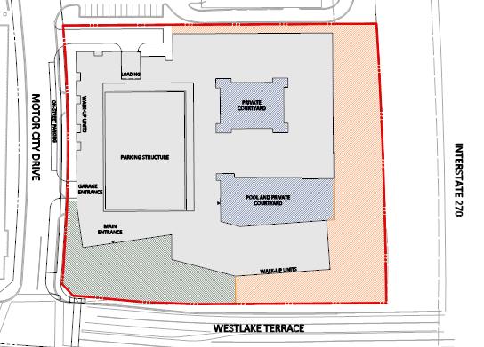
5 SECTION 3: PROJECT DESCRIPTION Proposal The Project will replace the existing structures and surface parking lot associated with the former automobile dealership with a residential redevelopment of up to 355,822 square feet (approximately 340 residential units, including MPDUs) in a 75-foot high building. The proposed project will achieve the maximum allowed residential density of 2.0 FAR of residential use for the Property; no retail space is proposed. The proposed building will be located close to the property lines along Motor City Drive and Westlake Terrace. Ground-level units are proposed on all four sides of the building with stoops and to encourage daily interaction and engagement among neighbors. At the street level, the facades will be mostly glass; however, final facade articulation will be determined at site plan review. The main pedestrian entrance to the building is from the plaza at the corner of Westlake Terrace and Motor City Drive. The building will have a structured parking garage for approximately 373 vehicles and parking spaces for bicycles. The parking garage will have vehicular access from Motor City Drive; the service dock is on the north side of the building accessed via a short driveway from Motor City Drive (Figure 3). Open Space The proposed Public Open Space of 17,786-square feet equals 10% of the tract area and will be located at the corner of Motor City Drive and Westlake Terrace intersection (Figures 3 and 6). It will function as an entry space at the main entrance of the building, and includes hard and soft landscape areas, plants, seating and other open space amenities. It is designed to encourage pedestrian and bicycle connections to the surrounding existing uses. In addition to the public open space, the Applicant proposes a vegetated area with a trail at the east and south sides of the Property that is not part of the public open space calculations. The trail is intended to provide active and passive recreation opportunities primarily for residents and will be accessible to the public only during daylight hours. The project also includes two private courtyards, one with an outdoor swimming pool open facing the I-270 spur, and the other entirely enclosed within the residential building. Community Outreach On May 25, 2017, the Applicant held a pre-submittal meeting at the Davis Library at 6400 Democracy Boulevard, Bethesda, which was attended by three people. The Applicant has complied with all submittal and noticing requirements. Staff has not received any correspondence as of the date of this report. 5


6 N Figure 3: Proposed Sketch Plan Figure 4: Proposed Building Massing 6


7 Figure 5: Building Cross-Section Facing North Figure 6: Public Open Space 7

 Figure 8: Vehicular")
8 Figure 7: Bicycle and Pedestrian Circulation (Pedestrian paths = blue dashed lines, Existing On-street striped Bike Lanes = tan dashed lines, Future 2-way separated Bike Lanes = green dashed line) Figure 8: Vehicular Circulation 8

9 Figure 9: Solar Study 9
10 SECTION 4: ANALYSIS AND FINDINGS The purpose of a Sketch Plan is to identify general land uses, development intensity, and public benefits for the optional method of development in the CR, CRT, EOF, or LSC Zones. The Sketch Plan is intended to be conceptual in nature with an emphasis on building densities, massing, heights and anticipated uses, the locations of open and public use spaces, the general circulation patterns for all modes of transportation, an estimated range of peak-hour trips and relationships between existing or proposed adjacent buildings and rights-of-way. Details of the proposed development are determined during Preliminary and Site Plan review. Section E of the Zoning Ordinance states: To approve a sketch plan the Planning Board must find that the following elements are appropriate in concept and appropriate for further detailed review at site plan. The sketch plan must: 1. meet the objectives, general requirements, and standards of this Chapter; Section 4.51.C. Commercial Residential Town (CRT) states that, The CRT Zone is intended for small downtown, mixed-use, pedestrian-oriented centers and edges of larger, more intense downtown. Retail tenant ground floor footprints are limited to preserve the town center scale. Transit options may include light rail, Metro, and bus. The proposed Sketch Plan meets the CRT Zone s objectives by adding multi-unit residential uses to an area that currently is dominated by non-residential uses including Westfield Montgomery Mall, and Rock Spring office district to the east (the letter has recently added a townhouse development along Westlake Terrace/Fernwood Drive). The proposed entrance plaza at the corner of Westlake Terrace and Motor City Drive will add more pedestrian activity long these streets. The Project will put approximately 340 multi-unit apartments across the street from an existing transit center that provides rapid bus service to the Grosvenor Metro Station. The development standards of the CRT Zone will be met as demonstrated in Table 1 below. Table 1: Development Standards for the CRT 2.5, C1.5, R2.0, H75 Zone Development Standard Section 59- Permitted/Required Proposed Gross Tract Area (sf) 177,911 sf 177,859 sf Maximum Total Density (CR) Maximum Non-residential (C) Maximum Residential (R) 2.5 FAR (444,778 sf) 1.5 FAR (266,867 sf) 2.0 FAR (355,822 sf) 2.0 FAR (355,822 sf) 0.0 FAR (0 sf) 2.0 FAR (355,822 sf) Maximum Building Height (feet) Minimum Public Open Space 10% (or 17,786 sf) 10% (or 17,786 sf) Minimum/Maximum Parking Multi-family Minimum: 1 space/unit; Maximum: 1 space/studio, 1.25 space/one bedroom, 1.5/two bedroom = 323 TBD at Site Plan 10
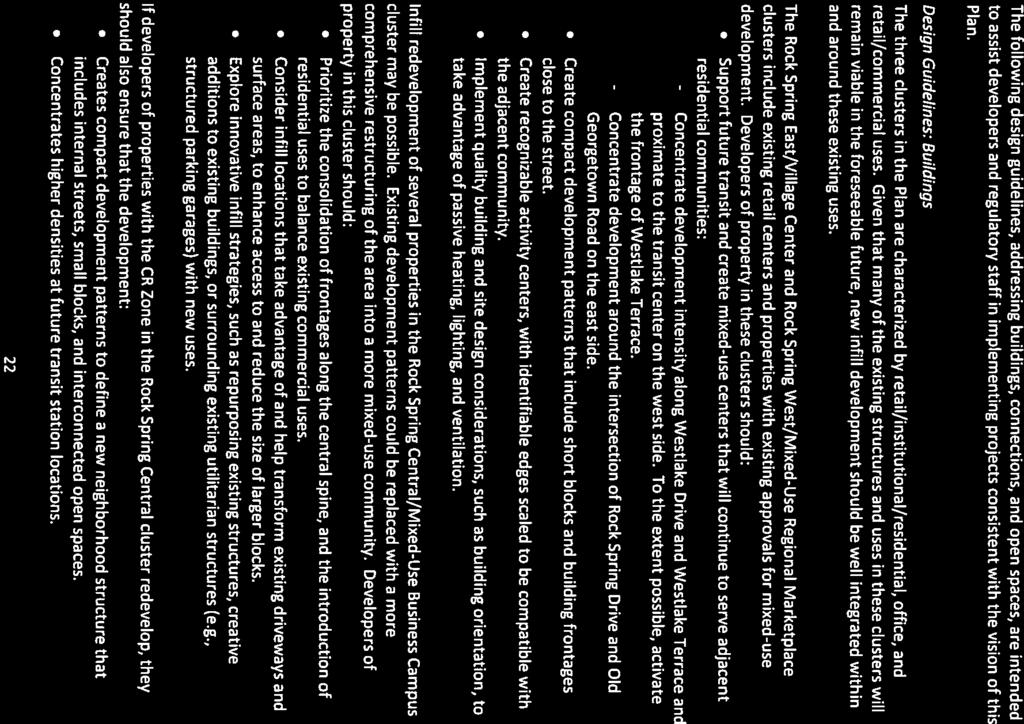
11 2. substantially conform with the recommendation of the applicable master plan; Rock Spring Master Plan The Property is within the Rock Spring West District of the 2017 Rock Spring Master Plan. The Plan includes this property in the discussion of pipeline development in the area and describes how these approved but unbuilt projects would support the central spine concept in the plan by delivering a mix of uses and improvements to the public realm that will start to reshape the Plan area into a connected, cohesive community that is more pedestrian and bicycle friendly for employees, residents, students, and visitors (pgs.16 and 17) (Attachment 1). The Applicant has incorporated the following applicable design guidance from the Rock Spring Master Plan in the proposed Sketch Plan: Buildings (p. 22) (Attachment 1): - Concentrate development intensity along Westlake Drive and Westlake Terrace and proximate to the Transit Center on the West Side. To the extent possible, activate the frontage of Westlake Terrace. - Implement quality building and site design considerations, such as building orientation to take advantage of passive heating, lighting, and ventilation. - Prioritize consolidation of frontage along the central spine, and the introduction of residential uses to balance existing commercial uses. The proposed project adds new housing along Westlake Terrace across the street from the Transit Center. It provides a plaza and the main building entrance along Westlake Terrace that will activate this street. The applicant has conducted a solar study to demonstrate that the building orientation will maximize solar gain in the winter months and provide shade for the interior courtyards and the pool area in the summer (figure 9). The project will bring residential units to a predominantly commercial area directly across the street and from the Transit Center, and transform a former automobile dealership site into a block with urban street frontages and public and private open spaces. Connectivity and Open Space (p.23) (Attachment 1): - Improve the public realm along existing connections with wider sidewalks and landscaped areas to enhance pedestrian access between developing properties, the central spine, and adjacent communities. - Consolidate the areas designated for public open space as part of the development process into usable, substantial, active, programmed, and accessible spaces. The project proposes a public plaza at the corner of Westlake Terrace and Motor City Drive, which will also act as the main pedestrian entrance to the building. This space will be an attractive addition to the network of sidewalks and other open spaces in the surrounding neighborhood. The proposed project also improves an existing PEPCO easement along I-270 to 11
12 provide a walking loop around the site that will connect to the network of public sidewalks in the area. 3. satisfy any development plan or schematic development plan in effect on October 29, 2014; The Sketch Plan is not subject to a development plan or schematic development plan. 4. achieve compatible internal and external relationships between existing and pending nearby development; The proposed building height of 75 feet will be compatible with the existing Pinnacle Business Center to the north and to the buildings in the Rock Spring Office Park to the east on the other side of I-270 spur. The Pinnacle Business Center is approximately six-stories and the buildings across the I-270 spur are mid- to hi-rise. The Property is the first in the area to be developed under the CRT Zone, as recommended in the Rock Spring Master Plan. As several nearby sites undergo redevelopment in the future, they will have similar building heights as the proposed building and compatibility will be achieved as envisioned in the Rock Spring Master Plan. 5. provides satisfactory general vehicular, pedestrian, and bicyclist access, circulation, parking and loading; Available Transit Service Five Ride On bus routes and two Metrobus routes operate along Westlake Terrace with stops at the Montgomery Mall Transit Center that is across Westlake Terrace from the proposed project. Pedestrian Facilities The Applicant will upgrade the existing sidewalks along Westlake Terrace and Motor City Drive with handicap ramps, crosswalks, and other pedestrian improvements, which will provide a safe pedestrian connection from the site to Montgomery Mall, the Transit Center, and other pedestrian facilities in and around the area. Master-Planned Roadways and Bikeways The following master plans have recommendations for planned transportation facilities adjacent to the proposed project: 2005 Countywide Bikeways Functional Master Plan, 2013 Countywide Transit Corridors Functional Master Plan 2017 Rock Spring Master Plan, and The Current Bicycle Master Plan update. Westlake Terrace is designated as a business district street, B-3, in the Rock Spring Master Plan, with a recommended 90-foot right-of-way. The current right-of-way is smaller than 90 feet; the Applicant must dedicate nine more feet of additional right-of-way at Site Plan review. The Countywide Bikeways Functional Master Plan recommends a bikeway along the south side. The Bikeways Master Plan update recommends a separated, two-way bikeway on the south side. The Countywide Transit Corridors Functional Master Plan recommends Corridor 6, North Bethesda Transitway, along Westlake Terrace. 12
13 Dwight Eisenhower Highway (I-270) West Spur is designated as a freeway, F-1a, with a recommended 300-foot right-of-way. The Maryland State Highway Administration (SHA) has two on-going projects along the segment of I-270 adjacent to the Property: 1) the I-270 Congestion Management Project; and 2) Capital Improvements Program (CIP) Project No. AW518B11, West Side Mobility Study for express toll lanes along I-270 between I-495 and I-370. Motor City Drive is a designated business district street, B-7, in the Rock Spring Master Plan with a recommended 70-foot right-of-way. It currently has 35 feet from its centerline to the Property s edge. No bikeway is recommended in the applicable master plans. The existing and proposed vehicular, bicycle, and pedestrian circulation facilities will be appropriate. The proposed parking and loading will be adequate to serve the proposed development. The total number of parking spaces will be determined at Site Plan review. 6. propose an outline of public benefits that supports the requested incentive density and is appropriate for the specific community; Taking into account the considerations in Section B., including the recommendations and objectives of the Master Plan and any applicable design guidelines, the Incentive Density Implementation Guidelines, the size and configuration of the Site and its relationship to adjacent properties, similar public benefits nearby, and additional enhancements related to the individual public benefits, Staff finds that the following outline of public benefits supports the Applicant s request for incentive density and is appropriate for the community surrounding the site, as described below. For optional method developments in the CRT Zone, the Zoning Ordinance requires a minimum of 50 points in at least three categories. Although at the time of Sketch Plan review, only the categories need to be approved, Table 2 below shows both the categories and points for public benefits requested in the Application to demonstrate the project s ability to meet the requirement to provide sufficient public benefits points. The Site Plan review will include the specific details of each requested subcategory, demonstrate how each will be implemented, and make recommendations to the Planning Board for the number of points that should be granted for each public benefit. The recently approved Rock Spring Master Plan recommends that all optional method projects in the master plan area should provide 15% MPDUs as the highest priority public amenity for new residential developments, unless the property is required to dedicate land for a school site or athletic fields that can be used by Montgomery County Public Schools (MCPS) and approximate the size of a local park. The proposed project was initiated and reviewed by Staff long before the Council s PHED Committee added this recommendation to the Planning Board Draft of the Master Plan, and therefore does not include 15% MPDUs as a public amenity to earn benefit points; nor does it dedicate land for a school or athletic fields. Staff agrees with the Applicant s assertion that this recommendation was added to the Draft Master Plan at a very late stage in the development review process (approximately one week before the publication 13
14 of this report), and that the Sketch Plan application has gone through significant Staff review, including the Development Review Committee (DRC) without consideration of this eleventh hour revision to the Draft Master Plan. Instead, Staff has been working with the Applicant to provide appropriate amenities to help the project achieve needed benefit points. Therefore, Staff is recommending that the Applicant not be required to provide 15% MPDUs. Table 2: Public Benefit Calculations Public Benefit Categories/Amenities A: Major Public Facilities Max Points Allowed Points Requested Bikeshare Station B: Transit Proximity Level 2 Transit Proximity C: Connectivity and Mobility Minimum Parking D: Diversity of Uses and Activities Enhanced Accessibility E: Quality Building and Site Design Structured Parking F: Protection and Enhancement of the Natural Environment Cool Roof 10 5 Vegetated Area TOTAL Major Public Facility Bikeshare Station: Bikeshare stations provide public amenity at a convenient location where increased density creates a greater need for civic uses and greater demands on public infrastructure. The Applicant is proposing a bikeshare station and requesting 5 points in this category; Staff supports the request at this time. 14
15 Transit Proximity The Property is adjacent (across Westlake Terrace) to the Westfield Montgomery Mall Transit Center for the master planned bus line running along Westlake Terrace, which is defined as Level 2 transit in the Zoning Ordinance. The Applicant is requesting 15 points in this subcategory; Staff supports the request at this time. Connectivity and Mobility Minimum Parking: The Applicant is requesting points for providing fewer than the maximum allowed number of parking spaces. Points for this incentive are granted on a sliding scale from no points for providing the maximum allowed to 10 points for providing no more than the minimum number of required parking spaces on-site. The minimum required number of on-site spaces is 323 and the Applicant is proposing 373 parking spaces. The final number of parking spaces will be determined at Site Plan. The Applicant is requesting 5 points in this subcategory; Staff supports the request at this time. Diversity of Uses and Activities Enhanced Accessibility for Seniors or the Disabled: Points in this category are granted for a development that increases the mix of land uses, types of housing, economic variety and community activities; contributes to development of more efficient and sustainable communities; reduces the necessity of automobile use; and facilitates healthier lifestyles and greater social interaction. Up to seven of the proposed ground-level units will be constructed with interiors that satisfy American National Standards Institute A117.1 Residential Type A standards, or an equivalent County standard. The Applicant is requesting 6 points in this subcategory; Staff supports the request at this time. Quality Building and Site Design Structured Parking: Points are granted in this category for high quality design that is especially important in urban, integrated-use settings to ensure that buildings and uses are visually compatible with each other and adjacent communities, and the pattern of development is harmonious. Due to increased density in these settings, buildings tend to be highly visible and high-quality design helps attract residents, patrons, and businesses to these areas. The Applicant is proposing to include all off-street parking in a parking garage, which will be wrapped around on all sides with residential units. The Applicant is requesting 10 points in this subcategory; Staff supports the request at this time. Protection and Enhancement of the Natural Environment Cool Roof: Up to 10 points are granted in this subcategory for constructing any roof area (that is not covered by a vegetated roof) with a minimum solar reflectance index (SRI) of 75 for roofs with a slope at or below a ratio of 2:12, and a minimum SRI of 25 for slopes above 2:12. The Applicant is proposing a cool roof and is requesting 5 points in this subcategory; Staff supports the request at this time. Vegetated Area: Up to 10 points for installation of plantings in a minimum of 12 inches of soil, covering at least 5,000 square feet. This area does not include vegetated roofs or stormwater 15
16 management facilities. The Applicant is proposing a vegetated area on the eastern part of the Site and is requesting 10 points in this subcategory; Staff supports the request at this time. 7. establish a feasible and appropriate provisional phasing plan for all structures, uses, rights-ofway, sidewalks, dedications, public benefits, and future preliminary and site plan applications. Conclusion The Project will be built in one phase. The Sketch Plan application satisfies the findings under Section of the Zoning Ordinance and substantially conforms to the recommendations of the 2017 Rock Spring Master Plan. Comments from review agencies were received and considered in the analysis and recommended conditions (Attachment 2). Staff recommends approval of Sketch Plan No with conditions at the front of this report. ATTACHMENTS 1. Master Plan pages (16, 17, 22 and 23) 2. Agency letters of approval 16

17 ATTACHMENT 1


18 ATTACHMENT 1
19 ATTACHMENT 1
20 ATTACHMENT 1

21 ATTACHMENT 2
22 ATTACHMENT 2
23 ATTACHMENT 2
24 ATTACHMENT 2
25 ATTACHMENT 2
26 ATTACHMENT 2
MONTGOMERY COUNTY PLANNING DEPARTMENT THE MARYLAND-NATIONAL CAPITAL PARK AND PLANNING COMMISSION
 MONTGOMERY COUNTY PLANNING DEPARTMENT THE MARYLAND-NATIONAL CAPITAL PARK AND PLANNING COMMISSION MCPB Item No. Date: 1/26/12 Hanover Shady Grove, Sketch Plan 320120020 Joshua Sloan, Coordinator, Joshua.Sloan@MontgomeryPlanning.org,
JUSTIFICATION STATEMENT FOR SKETCH PLAN NO Sketch Plan Justification for Ourisman Ford
 I. INTRODUCTION JUSTIFICATION STATEMENT FOR SKETCH PLAN NO. 320170100 Sketch Plan Justification for Ourisman Ford Owner and Applicant, FP Whitro Westlake, LLC ( Applicant ), by its attorneys, Linowes and
MONTGOMERY COUNTY PLANNING DEPARTMENT
 MONTGOMERY COUNTY PLANNING DEPARTMENT THE MARYLAND-NATIONAL CAPITAL PARK AND PLANNING COMMISSION MCPB Item No.: Date: 5-03-18 Pike and Rose, Phase I: Site Plan Amendment No. 82012002D Rhoda Hersson-Ringskog,
MONTGOMERY COUNTY PLANNING DEPARTMENT THE MARYLAND-NATIONAL CAPITAL PARK AND PLANNING COMMISSION
 MONTGOMERY COUNTY PLANNING DEPARTMENT THE MARYLAND-NATIONAL CAPITAL PARK AND PLANNING COMMISSION MCPB Item No. Date: 11-16-17 Hillandale Gateway, Sketch Plan, 320180020 Summary Lori Shirley, Planner Coordinator,
MONTGOMERY COUNTY PLANNING DEPARTMENT
 MONTGOMERY COUNTY PLANNING DEPARTMENT THE MARYLAND-NATIONAL CAPITAL PARK AND PLANNING COMMISSION MCPB Item # Date: 9-6-18 Ourisman Ford at Montgomery Mall, Site Plan No. 82009014B Emily Tettelbaum, Planner
MONTGOMERY COUNTY PLANNING DEPARTMENT THE MARYLAND-NATIONAL CAPITAL PARK AND PLANNING COMMISSION
 MONTGOMERY COUNTY PLANNING DEPARTMENT THE MARYLAND-NATIONAL CAPITAL PARK AND PLANNING COMMISSION MCPB Item No. Date: 12-10-15 Leisure World Clubhouse II Addition Fitness Center, Limited Site Plan Amendment
MONTGOMERY COUNTY PLANNING DEPARTMENT THE MARYLAND-NATIONAL CAPITAL PARK AND PLANNING COMMISSION
 MONTGOMERY COUNTY PLANNING DEPARTMENT THE MARYLAND-NATIONAL CAPITAL PARK AND PLANNING COMMISSION MCPB Item No. 8 Date: 12-15-16 Montgomery Village Center Sketch Plan No. 320170020 TL Troy Leftwich, Senior
MONTGOMERY COUNTY PLANNING DEPARTMENT
 MONTGOMERY COUNTY PLANNING DEPARTMENT THE MARYLAND-NATIONAL CAPITAL PARK AND PLANNING COMMISSION MCPB Item No. Date: 04/05/2018 850 Sligo Avenue Sketch Plan No. 320180090 Neil Sullivan, Planner Coordinator,
MONTGOMERY COUNTY PLANNING DEPARTMENT THE MARYLAND-NATIONAL CAPITAL PARK AND PLANNING COMMISSION
 MONTGOMERY COUNTY PLANNING DEPARTMENT THE MARYLAND-NATIONAL CAPITAL PARK AND PLANNING COMMISSION MCPB Item No. Date: 12/11/2014 Ripley East Sketch Plan No. 320150010 SD Stephanie Dickel, Planner Coordinator,
MONTGOMERY COUNTY PLANNING DEPARTMENT THE MARYLAND NATIONAL CAPITAL PARK AND PLANNING COMMISSION
 MONTGOMERY COUNTY PLANNING DEPARTMENT THE MARYLAND NATIONAL CAPITAL PARK AND PLANNING COMMISSION MCPB Item No. Date: 5.3.18 8000 Wisconsin Avenue Sketch Plan No. 320180120 Matthew Folden, Planner Coordinator,
MONTGOMERY COUNTY PLANNING DEPARTMENT THE MARYLAND-NATIONAL CAPITAL PARK AND PLANNING COMMISSION
 MONTGOMERY COUNTY PLANNING DEPARTMENT THE MARYLAND-NATIONAL CAPITAL PARK AND PLANNING COMMISSION MCPB Item No. Date10/25/12 Sketch Plan No. 32012004, White Flint Mall Redevelopment Nkosi Yearwood, Senior
MONTGOMERY COUNTY PLANNING DEPARTMENT THE MARYLAND-NATIONAL CAPITAL PARK AND PLANNING COMMISSION
 MONTGOMERY COUNTY PLANNING DEPARTMENT THE MARYLAND-NATIONAL CAPITAL PARK AND PLANNING COMMISSION MCPB Item No. Date: 05/12/2016 North Bethesda Conference Center Parking Structure, Mandatory Referral No.
MONTGOMERY COUNTY PLANNING DEPARTMENT
 MONTGOMERY COUNTY PLANNING DEPARTMENT THE MARYLAND-NATIONAL CAPITAL PARK AND PLANNING COMMISSION MCPB Consent Date: 4-26-18 Cabin John Auto Park (N. Bethesda Home Depot), Site Plan Amendment No. 81980017A
The subject site plan amendment proposes the following revisions to the approved site plan:
 PROPOSED AMENDMENT The subject site plan amendment proposes the following revisions to the approved site plan: 1. The building footprint was modified to accommodate the revised architectural design. 2.
MONTGOMERY COUNTY PLANNING DEPARTMENT THE MARYLAND-NATIONAL CAPITAL PARK AND PLANNING COMMISSION
 MONTGOMERY COUNTY PLANNING DEPARTMENT THE MARYLAND-NATIONAL CAPITAL PARK AND PLANNING COMMISSION MCPB Item No. Date: 04/24/2014 Sketch Plan No. 320140020, AVA Wheaton Michael Brown, Planner Coordinator,
Rock Spring Master Plan Community Meeting #8: Preliminary Recommendations
 Rock Spring Master Plan Community Meeting #8: Preliminary Recommendations July 18, 2016 Ι Walter Johnson High School Andrea Gilles, andrea.gilles@montgomeryplanning.org Ι www.montgomeryplanning.org/community/rockspring/
Gold Line Bus Rapid Transit Transit Oriented Development (BRTOD) Helmo Station Area Plan
 Helmo Station Area Plan") Appendix F Gold Line Bus Rapid Transit Transit Oriented Development (BRTOD) Helmo Station Area Plan Introduction and Purpose of the Plan The Gold Line Bus Rapid Transit facility is an eleven-mile dedicated
Appendix F Gold Line Bus Rapid Transit Transit Oriented Development (BRTOD) Helmo Station Area Plan Introduction and Purpose of the Plan The Gold Line Bus Rapid Transit facility is an eleven-mile dedicated
MONTGOMERY COUNTY PLANNING DEPARTMENT THE MARYLAND-NATIONAL CAPITAL PARK AND PLANNING COMMISSION
 MONTGOMERY COUNTY PLANNING DEPARTMENT THE MARYLAND-NATIONAL CAPITAL PARK AND PLANNING COMMISSION Staff Report: Sketch Plan #320110010, Mid-Pike Plaza ITEM #: MCPB HEARING DATE: January 20, 2011 REPORT
MONTGOMERY COUNTY PLANNING DEPARTMENT THE MARYLAND-NATIONAL CAPITAL PARK AND PLANNING COMMISSION
 MONTGOMERY COUNTY PLANNING DEPARTMENT THE MARYLAND-NATIONAL CAPITAL PARK AND PLANNING COMMISSION MCPB Item No. Date: 3.10.2016 Site Plan 820160040 Nora School Parker Smith, Planning Technician, Area 1,
MONTGOMERY COUNTY PLANNING DEPARTMENT THE MARYLAND-NATIONAL CAPITAL PARK AND PLANNING COMMISSION
 MONTGOMERY COUNTY PLANNING DEPARTMENT THE MARYLAND-NATIONAL CAPITAL PARK AND PLANNING COMMISSION MCPB Item No. Date: 05-22-14 Consent Item - Park Potomac: Site Plan Amendment No. 82004015K MCS. Molline
Westwood Shopping Center Sketch Plan, Plan # February 23, 2017 Item # 9
 Westwood Shopping Center Sketch Plan, Plan # 320170010 February 23, 2017 Item # 9 Westwood II Site 64,111 s.f. Manor Care site: vacant two story building HOC-Westwood Towers, 15 story tower To be considered
DRAFT. October Wheaton. Design Guidelines
 October 2011 DRAFT Wheaton Design Guidelines 2 Draft - Design Guidelines - Wheaton Sector Plan Contents 04 Section 1: Introduction 06 Section 2: Context 08 Section 3: Design Guidelines 09 Goal 1: Create
MONTGOMERY COUNTY PLANNING DEPARTMENT
 MONTGOMERY COUNTY PLANNING DEPARTMENT THE MARYLAND-NATIONAL CAPITAL PARK AND PLANNING COMMISSION 6000 Executive Boulevard, Sketch Plan No. 320180140 MCPB Item No. Date: 06/21/2018 Emily Tettelbaum, Senior
Policies and Code Intent Sections Related to Town Center
 Policies and Code Intent Sections Related to Town Center The Town Center Vision is scattered throughout the Comprehensive Plan, development code and the 1994 Town Center Plan. What follows are sections
EXISTING COMPREHENSIVE PLAN
 EXISTING COMPREHENSIVE PLAN Town Center Land Use Element: V. LAND USE POLICIES Town Center Mercer Island's business district vision as described in "Your Mercer Island Citizen-Designed Downtown" was an
MONTGOMERY COUNTY PLANNING DEPARTMENT
 MONTGOMERY COUNTY PLANNING DEPARTMENT THE MARYLAND-NATIONAL CAPITAL PARK AND PLANNING COMMISSION Ashburton Elementary School Addition, Mandatory Referral, MR2018009 MCPB Item No. Date: 02-15-18 Troy Leftwich,
MONTGOMERY COUNTY PLANNING DEPARTMENT THE MARYLAND-NATIONAL CAPITAL PARK AND PLANNING COMMISSION
 MONTGOMERY COUNTY PLANNING DEPARTMENT THE MARYLAND-NATIONAL CAPITAL PARK AND PLANNING COMMISSION The Goddard School in North Bethesda Preliminary Plan Amendment 11996015B and Site Plan Amendment 82006005A
MONTGOMERY COUNTY PLANNING DEPARTMENT THE MARYLAND-NATIONAL CAPITAL PARK AND PLANNING COMMISSION
 MONTGOMERY COUNTY PLANNING DEPARTMENT THE MARYLAND-NATIONAL CAPITAL PARK AND PLANNING COMMISSION MCPB Item No. Date: 1/15/2015 Bethesda North Marriott Hotel and Conference Center: Limited Site Plan Amendment
REQUEST Current Zoning: O-15(CD) (office) Proposed Zoning: TOD-M(CD) (transit oriented development mixed-use, conditional)
 (office) Proposed Zoning: TOD-M(CD) (transit oriented development mixed-use, conditional)") Rezoning Petition 2016-117 Zoning Committee Recommendation January 4, 2017 REQUEST Current Zoning: O-15(CD) (office) Proposed Zoning: TOD-M(CD) (transit oriented development mixed-use, conditional) LOCATION
Rezoning Petition 2016-117 Zoning Committee Recommendation January 4, 2017 REQUEST Current Zoning: O-15(CD) (office) Proposed Zoning: TOD-M(CD) (transit oriented development mixed-use, conditional) LOCATION
STATEMENT OF JUSTIFICATION CLARKSBURG PREMIUM OUTLETS AT CABIN BRANCH NORTH DISTRICT, PHASE
 STATEMENT OF JUSTIFICATION CLARKSBURG PREMIUM OUTLETS AT CABIN BRANCH NORTH DISTRICT, PHASE 1 Southwest Corner of Clarksburg Road and Interstate-270 Clarksburg, Maryland Application for Site Plan #820140160
MONTGOMERY COUNTY PLANNING DEPARTMENT THE MARYLAND-NATIONAL CAPITAL PARK AND PLANNING COMMISSION
 MONTGOMERY COUNTY PLANNING DEPARTMENT THE MARYLAND-NATIONAL CAPITAL PARK AND PLANNING COMMISSION MCPB Item No. Date: 7/26/12 Camden Shady Grove (Danac Stiles), Sketch Plan 320120050 Joshua Sloan, Planner
MONTGOMERY COUNTY PLANNING DEPARTMENT THE MARYLAND-NATIONAL CAPITAL PARK AND PLANNING COMMISSION
 MONTGOMERY COUNTY PLANNING DEPARTMENT THE MARYLAND-NATIONAL CAPITAL PARK AND PLANNING COMMISSION MCPB Item No. Date: 9-4-13 Limited Site Plan Amendment No. 81994026B, Darcars at Montgomery Industrial Park,
Town Center (part of the Comprehensive Plan)
") Town Center (part of the Comprehensive Plan) Mercer Island Town Center Looking North (2014) In 1994, a year-long process culminated in a set of design guidelines and code requirements for the Town Center
Town Center (part of the Comprehensive Plan) Mercer Island Town Center Looking North (2014) In 1994, a year-long process culminated in a set of design guidelines and code requirements for the Town Center
MONTGOMERY COUNTY PLANNING DEPARTMENT THE MARYLAND-NATIONAL CAPITAL PARK AND PLANNING COMMISSION
 MONTGOMERY COUNTY PLANNING DEPARTMENT THE MARYLAND-NATIONAL CAPITAL PARK AND PLANNING COMMISSION MCPB Item No. Date: 7/30/2015 Pooks Hill Sketch Plan No. 320150060 Kathleen A. Reilly, AICP Planner Coordinator,
Proposed Comprehensive Plan Strategies DRAFT for discussion June 28, 2017
 Proposed Comprehensive Plan Strategies DRAFT for discussion June 28, 2017 Land Use Rural Areas Refine the Farm and Forest area (FF) Update FF boundaries to account for existing lots less than five acres
Rock Spring Master Plan Community Meeting #6: Land Use + Transportation Forecasts
 Rock Spring Master Plan Community Meeting #6: Land Use + Transportation Forecasts May 23, 2016 Ι Walter Johnson High School Andrea Gilles, andrea.gilles@montgomeryplanning.org Ι www.montgomeryplanning.org/community/rockspring/
MONTGOMERY COUNTY PLANNING DEPARTMENT THE MARYLAND-NATIONAL CAPITAL PARK AND PLANNING COMMISSION
 MONTGOMERY COUNTY PLANNING DEPARTMENT THE MARYLAND-NATIONAL CAPITAL PARK AND PLANNING COMMISSION MCPB Item No. Date: 06-12-14 King of the Nations Christian Fellowship Church: Limited Site Plan Amendment
MONTGOMERY COUNTY PLANNING DEPARTMENT
 MONTGOMERY COUNTY PLANNING DEPARTMENT THE MARYLAND-NATIONAL CAPITAL PARK AND PLANNING COMMISSION MCPB Item No. Date: 11-8-18 Strathmore Square, Sketch Plan 320190010 Emily Tettelbaum, Planner Coordinator,
MONTGOMERY COUNTY PLANNING DEPARTMENT THE MARYLAND-NATIONAL CAPITAL PARK AND PLANNING COMMISSION
 MONTGOMERY COUNTY PLANNING DEPARTMENT THE MARYLAND-NATIONAL CAPITAL PARK AND PLANNING COMMISSION MCPB Item No. Date: 04/05/2018 Solera Reserve at Kensington, Sketch Plan No. 320180080 Description Garry
PROJECT NARRATIVE AND JUSTIFICATION STATEMENT
 7000 WISCONSIN AVENUE SKETCH PLAN NO. 320190090 PROJECT NARRATIVE AND JUSTIFICATION STATEMENT I. INTRODUCTION Starr Capital LLC and Woodfield Development Company (collectively, the Applicant ) are the
The transportation system in a community is an
 7 TRANSPORTATION The transportation system in a community is an important factor contributing to the quality of life of the residents. Without a sound transportation system to bring both goods and patrons
3. VISION AND GOALS. Vision Statement. Goals, Objectives and Policies
 Vision Statement Queen Creek s interconnected network of parks, trails, open spaces and recreation opportunities provide safe and diverse activities and programs that sustain its unique, small town, equestrian
The West Vaughan Employment Area Secondary Plan Policies
 Part 2: The West Vaughan Employment Area Secondary Plan Policies 2.1 General Policies It is the policy of Council: 2.1.1. That the West Vaughan Employment Area (the WVEA), identified on Schedule 1, will
MONTGOMERY COUNTY PLANNING DEPARTMENT THE MARYLAND-NATIONAL CAPITAL PARK AND PLANNING COMMISSION
 MONTGOMERY COUNTY PLANNING DEPARTMENT THE MARYLAND-NATIONAL CAPITAL PARK AND PLANNING COMMISSION Gables White Flint, Preliminary Plan No. 120150010 and Site Plan No. 820150010 MCPB Item No. Date: 4/30/2015
DRAFT. 10% Common Open Space
 % OF CHARLOTTE IS CATEGORIZED AS A. LAND USES : Placeholder map displaying location of Place Type GOALS: Accommodate XX% of future growth. Provide a concentration of primarily commercial and civic activity
Description of Preferred Alternative
 Chapter 2 Description of Preferred Alternative 2.1 Introduction This chapter of the programmatic Sammamish Town Center Sub-area Plan Final EIS provides a more detailed description of the Preferred Alternative
JUSTIFICATION STATEMENT FOR SITE PLAN NO Site Plan Justification for Chevy Chase Lake Townhouses
 I. INTRODUCTION JUSTIFICATION STATEMENT FOR SITE PLAN NO. 820150050 Site Plan Justification for Chevy Chase Lake Townhouses Applicant, CC Associates LLC (the Applicant ), by its attorneys, Linowes and
SPRINGHILL LAKE TRANSIT VILLAGE
 Greenbelt Metro Area Sector Plan - Subarea Design Policies and Guidelines - Springhill Lake Transit Village 113 SPRINGHILL LAKE TRANSIT VILLAGE Residential Neighborhood and Village Center CONCEPT Springhill
4.1.3 LAND USE CATEGORIES
 4.1.3 LAND USE CATEGORIES a. City Center District The City Center District incorporates the existing character and mix of uses in downtown Belmont to encourage redevelopment and new development in keeping
City of Fairfax, Virginia City Council Work Session
 City of Fairfax, Virginia City Council Work Session Agenda Item # WS 2 City Council Meeting 7/5/2016 TO: FROM: SUBJECT: Honorable Mayor and Members of City Council Robert Sisson, City Manager Request of
S C O P E O F W O R K A P R I L
 white flint 2 sector plan S C O P E O F W O R K A P R I L 2 0 1 2 MONTGOMERY COUNTY PLANNING DEPARTMENT M-NCPPC MontgomeryPlanning.org 1 white flint 2 sector plan Scope of Work abstract This scope of work
Wheaton CBD & Vicinity Sector Plan D E S I G N G U I D E L I N E S
 Wheaton CBD & Vicinity Sector Plan D E S I G N G U I D E L I N E S 1 a b s t r a c t This document contains the design guidelines the property owners, community members, and planners should use to implement
VILLAGE OF CLEMMONS PLANNING BOARD DRAFT STAFF REPORT
 VILLAGE OF CLEMMONS PLANNING BOARD DRAFT STAFF REPORT PETITION INFORMATION Docket # C-226 Staff Megan Ledbetter Petitioner(s) JBJH Properties, LLC Owner(s) JBJH Properties, LLC Subject Property 5892-49-1766
Silver Line CPAM UPDATE. Transportation and Land Use Committee October 14, 2016
 Silver Line CPAM UPDATE Transportation and Land Use Committee October 14, 2016 Purpose Recap Project History and Map Changes Provide Overview of CPAM Components Discuss Transportation Impacts Discuss Fiscal
Ripley East. Sketch Plan Amendment No A Preliminary Plan No Site Plan No MONTGOMERY COUNTY PLANNING DEPARTMENT
 Ripley East Sketch Plan Amendment No. 32015001A Preliminary Plan No. 120150220 Site Plan No. 820150130 Planning Board Hearing Date: December 3, 2015 Site Vicinity and Site Description Silver Spring Transit
MONTGOMERY COUNTY METRO STATION AREA DESIGN CHARRETTE
 MONTGOMERY COUNTY METRO STATION AREA DESIGN CHARRETTE Shady Grove Metro Station Area Charrette Closing Presentation October 25-28, 2000 MONTGOMERY COUNTY, MD M-NCPPC Design Collective, Inc. Architects
MONTGOMERY COUNTY PLANNING DEPARTMENT THE MARYLAND-NATIONAL CAPITAL PARK AND PLANNING COMMISSION
 MONTGOMERY COUNTY PLANNING DEPARTMENT THE MARYLAND-NATIONAL CAPITAL PARK AND PLANNING COMMISSION MCPB Item No. 6 Date: 5-9-13 Site Plan No. 820130090, West Chevy Chase Heights Erin Grayson, Senior Planner,
MIXED-USE VILLAGE OVERLAY FLOATING DISTRICT
 MIXED-USE VILLAGE OVERLAY FLOATING DISTRICT Zoning regulations developed by committee to the Planning Board for the Town of DeWitt, NY Issue date: 13 July 2017 revised 3/12/2018, revised 4/26/2018, 5/9/2018
Executive Summary. NY 7 / NY 2 Corridor
 Executive Summary NY 7 / NY 2 Corridor Transportation and Land Use Study December 2005 Prepared for: Town of Colonie Capital District Transportation Committee Prepared by: Introduction: Land use decisions
DRAFT Northeast Quadrant of Kipling Avenue and Highway 7 DRAFT AUGUST 29, Goals Land Use. The goals of this Plan are to:
 AUGUST 29, 2017 12.15 Northeast Quadrant of Kipling Avenue and Highway 7 12.15.1 Goals 12.15.2 Land Use The goals of this Plan are to: 12.15.2.1 General Provisions: a) Ensure the development of a compact
Developer s Program. The Station at East 54
 Developer s Program The Station at East 54 Existing Conditions The Station at East 54 is proposed for a 1.12 acre site at the northeast corner of Hamilton Road and Prestwick Road, tucked between the East
Figure 3-1: Public Realm Plan
 3 Public Realm Figure 3-1: Public Realm Plan 3.1 Public Realm Concept The public realm concept for the Little Mountain site integrates a clear and accessible movement network with public spaces for social
JUSTIFICATION STATEMENT FOR SKETCH PLAN NO Sketch Plan Justification for Wilgus
 JUSTIFICATION STATEMENT FOR SKETCH PLAN NO. 320190070 Sketch Plan Justification for Wilgus I. INTRODUCTION Owner and Applicant, Wilgus-Montrose Associates LLC ( Applicant ), by its attorneys, Linowes and
BROOKHILL NEIGHBORHOOD MODEL ZONING MAP AMENDMENT PREFACE TO APPLICATION
 BROOKHILL NEIGHBORHOOD MODEL ZONING MAP AMENDMENT PREFACE TO APPLICATION June 15, 2015 Revised: August 1, 2016 I. VISION Brookhill is a proposed community based upon the principles of Albemarle County
FORMER CANADIAN FORCES BASE (CFB) ROCKCLIFFE SECONDARY PLAN. Official Plan Amendment XX to the Official Plan for the City of Ottawa
 ROCKCLIFFE SECONDARY PLAN. Official Plan Amendment XX to the Official Plan for the City of Ottawa") FORMER CANADIAN FORCES BASE (CFB) ROCKCLIFFE SECONDARY PLAN Official Plan Amendment XX to the Official Plan for the City of Ottawa 1 INDEX THE STATEMENT OF COMPONENTS PART A THE PREAMBLE PAGE Purpose...
FORMER CANADIAN FORCES BASE (CFB) ROCKCLIFFE SECONDARY PLAN Official Plan Amendment XX to the Official Plan for the City of Ottawa 1 INDEX THE STATEMENT OF COMPONENTS PART A THE PREAMBLE PAGE Purpose...
Long Branch Sector Plan
 June 2012 Long Branch is one of Montgomery County s most affordable, older communities and has served as a gateway community, especially for newly arriving immigrants, since the 1960s. Many within this
Strathmore Square Sketch Plan Statement of Justification and Narrative Description
 Strathmore Square Sketch Plan Statement of Justification and Narrative Description I. Introduction Fivesquares Development, LLC (the "Applicant" or "Fivesquares") is submitting this application for Sketch
Lehigh Acres Land Development Regulations Community Planning Project
 Lehigh Acres Land Development Regulations Planning Effort Summary In July, 2010 Commissioner Frank Mann invited the Lehigh Acres community to start discussing how to achieve their recently adopted community
ARTICLE 6: Special and Planned Development Districts
 ARTICLE 6: Special and Planned Development Districts 6-10 Traditional Neighborhood Development (TND) District 6-10.10 Purpose and Intent The Traditional Neighborhood Development (TND) District provides
Planning Board Briefing
 Planning Board Briefing Why Now? The Sector Plan Implementation Chapter States: Before Stage 1 begins, the following must occur: Approval of the Sectional Map Amendment. Approval of the Greater Lyttonsville
Transportation. Strategies for Action
 Transportation A major priority for the Overlake Neighborhood is to develop a multimodal transportation system. To achieve this system, a balance has to be found among travel, circulation and access needs;
Michael Brown, Senior Planner, Area 2 Planning Division,
 THE MARYLAND-NATIONAL CAPITAL PARK AND PLANNING COMMISSION MCPB Item No. Date: 12-15-11 Glenmont Fire Station, Mandatory Referral, MR 2012007 Michael Brown, Senior Planner, Area 2 Planning Division, michael.brown@montgomeryplanning.org,
FUTURE LAND USE ELEMENT
 FUTURE LAND USE ELEMENT GOAL I: To create and sustain a great place to live, play, and prosper Objective 1: The City of Ocala shall incorporate the principles and strategies of the Ocala 2035 Vision into
The Development Review Process. Presentation to the GSSC IAC
 The Development Review Process Presentation to the GSSC IAC July 19, 2011 Regulatory Processes in the Planning Department Natural Resource Inventory/Forest Stand Delineation Zoning (Development Plan) Special
ELMVALE ACRES SHOPPING CENTRE MASTER PLAN
 ELMVALE ACRES SHOPPING CENTRE MASTER PLAN Contents 1.0 INTRODUCTION... 2 2.0 LOCATION... 2 3.0 EXISTING CONTEXT... 2 4.0 VISION & GUIDING PRINCIPLES... 2 5.0 LAND USE AND BUILT FORM... 4 5.1 St. Laurent
D1 September 11, 2013 Public Hearing APPLICANT:
 D1 September 11, 2013 Public Hearing APPLICANT: BEACH MUNICIPAL FEDERAL CREDIT UNION PROPERTY OWNER: SISTERS II, LLC STAFF PLANNER: Karen Prochilo REQUEST: Conditional Change of Zoning (AG-2 Agriculture
Town Center. Block 5 Existing multifamily residential units are expected to remain.
 Area Guidelines Germantown s districts should be developed as distinct communities with unique features that are supported through the guidelines. The guidelines not only help distinguish these districts
TOWN COUNCIL / PLANNING COMMISSION
 Workshop #3 TOWN COUNCIL / PLANNING COMMISSION January 20, 2011 Consultant Team In Attendance Tonight BMS Design Group Nevada City and San Francisco Michael Smiley, AICP, ASLA Partner-in-Charge Nancy L.
Clairtrell Area Context Plan
 Clairtrell Area Context Plan March 2005 Urban Development Services City Planning Contents 1. Introduction... 4 2. Development Structure... 6 2.1 Streets... 7 2.1.1 Sheppard Avenue and Bayview Avenue...
PORT WHITBY COMMUNITY
 PORT WHITBY COMMUNITY SECONDARY PLAN UPDATE COMMUNITY IMPROVEMENT PLAN URBAN DESIGN GUIDELINES September 2015 DRAFT PROPOSED AMENDMENT NUMBER # to the Whitby Official Plan PURPOSE: The intent of this Amendment
MONTGOMERY COUNTY PLANNING DEPARTMENT THE MARYLAND NATIONAL CAPITAL PARK AND PLANNING COMMISSION
 MONTGOMERY COUNTY PLANNING DEPARTMENT THE MARYLAND NATIONAL CAPITAL PARK AND PLANNING COMMISSION MCPB Item No. 8 Date: 3.30.2017 Project Name: Lot 31/31A Bethesda, Site Plan Amendment, No. 82007018C Elza
599 Kennedy Road - Official Plan Amendment and Zoning Amendment Application - Preliminary Report
 STAFF REPORT ACTION REQUIRED 599 Kennedy Road - Official Plan Amendment and Zoning Amendment Application - Preliminary Report Date: March 7, 2017 To: From: Wards: Reference Number: Scarborough Community
Preliminary Recommendations Tk Takoma/Langley Crossroads Sector Plan
 Preliminary Recommendations Tk Takoma/Langley Crossroads Sector Plan Vision is to achieve a Transit Oriented, pedestrian friendly Community that Celebrates and builds upon the cultural Diversity of the
14 October 10, 2012 Public Hearing APPLICANT: MPB, INC
 14 October 10, 2012 Public Hearing APPLICANT: MPB, INC PROPERTY OWNER: MUNDEN & ASSOCIATES, LP STAFF PLANNER: Karen Prochilo REQUEST: Conditional Change of Zoning (AG-1 & AG-2 to Conditional O-2) ADDRESS
McCowan Precinct Plan Study Background & Deliverables
 1 DRAFT & WITHOUT PREJUDICE McCowan Precinct Plan Study Background & Deliverables In September, 2011, City Planning (Scarborough District) began a study of an area within the Scarborough Centre, identified
I. Introduction. Prior Approvals
 Statement of Justification First National Bank 19790 Crystal Rock Drive, Germantown, Maryland Application for Site Plan and Limited Preliminary Plan Amendment I. Introduction DPH Architecture, for First
MONTGOMERY COUNTY PLANNING DEPARTMENT THE MARYLAND-NATIONAL CAPITAL PARK AND PLANNING COMMISSION
 MONTGOMERY COUNTY PLANNING DEPARTMENT THE MARYLAND-NATIONAL CAPITAL PARK AND PLANNING COMMISSION VIVA White Oak, Sketch Plan No. 320180040 MCPB Item No. Date: 11/30/2017 Description Patrick Butler, Planner
2 January 13, 2010 Public Hearing APPLICANT: AUTOBELL CAR WASH, INC
 REQUEST: Conditional Use Permit (car wash) 2 January 13, 2010 Public Hearing APPLICANT: AUTOBELL CAR WASH, INC PROPERTY OWNER: MESSER 1060 INDEPENDENCE BOULEVARD STAFF PLANNER: Carolyn A.K. Smith ADDRESS
Section 4 BUILDING THE MASTER PLAN
 The Master Plan 33 Section 4 BUILDING THE MASTER PLAN Figure 4:1. A collaborative effort characterized the two design workshops sponsored by DISC to create hypothetical Master Plans for the Towers Property
12 January 12, 2011 Public Hearing APPLICANT: TAILWIND DEVELOPMENT GROUP,LLC PROPERTY OWNER: CITY OF VIRGINIA BEACH
 12 January 12, 2011 Public Hearing APPLICANT: TAILWIND DEVELOPMENT GROUP,LLC PROPERTY OWNER: CITY OF VIRGINIA BEACH STAFF PLANNER: Faith Christie REQUEST: Conditional Change of Zoning (from PD-H1 Planned
Planned Development Review Revisions (Project No. PLNPCM )
") Planned Development Review Revisions (Project No. PLNPCM2014-00139) Standard residential development Planned Development Example: Smaller lot sizes than what is allowed to create open space amenity. What
Planned Development Review Revisions (Project No. PLNPCM2014-00139) Standard residential development Planned Development Example: Smaller lot sizes than what is allowed to create open space amenity. What
Seneca Meadows. Block 4 Locate office, technology, and medical development adjacent to I Screen views of garage structures from I-270.
 Seneca Meadows Seneca Meadows has an industrial park in its southern end and a mixed-use employment area planned for the north end. The district benefits from extensive I-270 visibility, stream valley
MONTGOMERY COUNTY PLANNING DEPARTMENT
 MONTGOMERY COUNTY PLANNING DEPARTMENT THE MARYLAND-NATIONAL CAPITAL PARK AND PLANNING COMMISSION North Bethesda Town Center Parcel G Site Plan No. 820180010 MCPB Item No.: Date: 01-25-18 Atul Sharma, Planner
Staff Report and Recommendation
 Community Planning and Development Planning Services 201 W. Colfax Ave., Dept. 205 Denver, CO 80202 p: 720.865.2915 f: 720.865.3052 www.denvergov.org/cpd TO: City Council Neighborhoods and Planning Committee
AWH REPORT OF THE PLANNING AND DEVELOPMENT DEPARTMENT FOR APPLICATION FOR REZONING ORDINANCE TO PLANNED UNIT DEVELOPMENT
 AWH REPORT OF THE PLANNING AND DEVELOPMENT DEPARTMENT FOR APPLICATION FOR REZONING ORDINANCE TO PLANNED UNIT DEVELOPMENT MAY 8, 2014 The Planning and Development Department hereby forwards to the Planning
The Village. Chapter 3. Mixed Use Development Plan SPECIFIC PLAN
 The Village SPECIFIC PLAN Chapter 3 3.1 INTRODUCTION 3.1.1 Purpose This Chapter describes the development regulations applicable to the Mixed-Use and Transit Center Planning Areas. These form-based regulations
2900 Steeles Avenue East at Don Mills Road in the Town of Markham
 STAFF REPORT INFORMATION ONLY 2900 Steeles Avenue East at Don Mills Road in the Town of Markham Date: January 23, 2008 To: From: Wards: Reference Number: North York Community Council Director, Community
CITY OF KEIZER MASTER PLAN APPLICATION & INFORMATION SHEET
 CITY OF KEIZER MASTER PLAN APPLICATION & INFORMATION SHEET PRE-APPLICATION CONFERENCE Prior to the actual filing of a Master Plan application, it is strongly recommended that the applicant contact Planning
TRANSIT ORIENTED DEVELOPMENT PINELLAS COUNTY MPO LIVABLE COMMUNITIES INITIATIVE PINELLAS COUNTY COMPREHENSIVE PLAN AMENDMENTS
 PINELLAS COUNTY MPO LIVABLE COMMUNITIES INITIATIVE MODEL LAND DEVELOPMENT CODE TRANSIT ORIENTED DEVELOPMENT PINELLAS COUNTY COMPREHENSIVE PLAN AMENDMENTS MPO Livable Communities Initiative Goal: Improve
12/9/2013. HOLLYWOOD/PINES CORRIDOR PROJECT AMPO 2013 Annual Conference October 24, Our Perspective. Broward.
 HOLLYWOOD/PINES CORRIDOR PROJECT AMPO 2013 Annual Conference October 24, 2013 Our Perspective Broward Fort Lauderdale 1 Broward Metropolitan Planning Organization Fort Lauderdale Fort Lauderdale Skyline