Huapai North. Variation 127 DECISIONS VERSION. Variation 127 Special 29 Zone
|
|
|
- Loren Merritt
- 5 years ago
- Views:
Transcription
1 Huapai North Variation 127 DECISIONS VERSION
2 DECISIONS VERSION The amendments to the Variation that have been made as a result of decisions on submissions are shown as strikethrough or underlined. RESOURCE MANAGEMENT ACT 1991 RODNEY DISTRICT PLAN 2000 OPERATIVE IN PART VARIATION NUMBER 127: INTRODUCTION OF SPECIAL 29 ZONE AND OTHER AMENDMENTS HUAPAI NORTH. 1.1 Schedule of Amendments: Chapter 3 - Definitions (1) Amend Chapter 3 Definitions by amending the definition of Residential Zone (additions underlined). means an area of land identified in the Plan which is primarily for residential use, and includes: (a) Low Intensity Residential (Res L) Zone (b) Landscape Protection Residential (Res LP) Zone (c) Medium Intensity Residential (Res M) Zone (d) Eastern Peninsula Residential (Res EP) Zone (e) Physical Limitation (Res PL) Zone (f) High Intensity (Res H) Zone (g) Garden Residential Policy Area within the Special 19 Zone (h) Huapai Low and Medium Residential Policy Areas and the Huapai Park Residential Policy Area within the Special 29 (Huapai North) Zone (2) Amend Chapter 3 Definitions by amending the definition of Urban Zone (additions underlined). Includes the following zones: (a) High Intensity Residential Zone (b) Medium Intensity Residential Zone (c) Eastern Peninsula Residential Zone (d) Physical Limitations Residential Zone (e) Low Intensity Residential Zone (f) Landscape Protection Residential Zone (g) Retail Service Zone (h) Mixed Business Zone (i) Industrial Zone (j) Special 19 Zone (k) Special 29 Zone
3 1.2 Schedule of Amendments: Chapter 12 Special Zones (1) Amend Chapter 12 Special Zones by including a new Special 29 (Huapai North) Zone including new Appendices 12Y (design guidelines) (see attached Annexure 1). 1.3 Schedule of Amendments: Chapter 13 Future Development and Structure Plans (1) Amend Section Future Urban Zone Description by deleting words from the second paragraph to read: (deletions struck through) This Zone applies to land at various locations through the District which is primarily to be used for residential purposes. The main areas include, Silverdale South, Orewa West, western and southern Warkworth, Algies Bay, Parakai, Helensville South, Huapai North, Riverhead, and northern Wellsford. The rules relating to the Zone aim to ensure that future coordinated development is not jeopardized by the introduction of incompatible uses, or by undue fragmentation of existing land holding. The range of activities and subdivision is accordingly restricted. (2) Amend Figure 1 Rodney District Structure Plan Areas by deleting reference to Huapai North (see plan shown in Annexure 2). (3) Amend Section Structure Plan Descriptions by deleting words from the third paragraph to read: (deletions struck through) Structure Plans for, McKinney Road (Warkworth), Helensville South, Huapai North, Silverdale South, Snells Beach Algies Bay and Wellsford are included in the Plan. Others will be added by plan change or variation as they are completed. (4) Amend Appendix 13A by deleting13.a.4 Huapai North Structure Plan Area in its entirety. 1.4 Schedule of Amendments: Chapter 14 Scheduled Activities (1) Amend Chapter 14 Scheduled Activities, specifically Rule : Restricted Activity Table by inserting a new Restricted Activity 335 as shown below (additions underlined): ACTIVITY NUMBER DETAILS 335 MAP REFERENCE 110 and 112 LOCATION AND LEGAL DESCRIPTION Lot 2 DP , Lot 1 DP , Lot 2 DP 59461, Lot 1 DP and Lot DP RESTRICTIONS ON
4 THE ACTIVITY/SITE Assessment Criteria Assessment Criteria The following additional assessment criteria shall apply to any resource consent on the subject land: (a) Whether the proposed subdivision provides a spatial buffer from the existing horticultural activities occurring on Lot 2 DP as shown in Appendix 14AC. (b) Whether the proposed activity or future development rights as a result of subdivision, will result in reverse sensitivity effects associated with the existing horticultural activities occurring on Lot 2 DP (c) Whether the design of any subdivision and the location of any residential dwellings will result in any reverse sensitivity effects due to noise, light glare, odour or other effects likely to be generated from the existing flower growing operation on Lot 2 DP (d) Whether mechanisms have been included in the proposal to ensure that future land owners and occupiers are aware of the horticultural operations on Lot 2 DP through consent notices. (e) Whether mechanisms such as consent notices, have been included in the proposal to ensure that any proposed measures to avoid, mitigate or remedy effects, such as planting and spatial non build areas are maintained. (2) Amend Chapter 14 Scheduled Activities by adding a new Appendix 14AC (as set out in Annexure 7). (3) Amend Chapter 14 Scheduled Activities, specifically Rule : Restricted Activity Table by inserting a new Restricted Activity 336 as shown below (additions underlined): ACTIVITY NUMBER DETAILS 336 MAP REFERENCE 110 and 112 LOCATION AND LEGAL DESCRIPTION Lot 2 DP RESTRICTIONS ON THE ACTIVITY/SITE Activities/Buildings Activities/Buildings (i) The following activities shall be Discretionary activities where they are proposed in the Physical Limitations Policy Overlay
5 Area (as shown on Appendix 9, Figure 1 of the District Plan Maps) until such time as the site has been subdivided for residential purposes in accordance with the Huapai Low Intensity Policy Area subdivision rules and Section 224 certificates under the Resource Management Act 1991 have been obtained, at which time this rule shall no longer apply. (a) Buildings: The erection, addition to or external alteration to and/or relocation of buildings. (b) Earthworks Assessment Criteria Assessment Criteria The following additional assessment criteria shall apply to any resource consent for buildings and earthworks required under rule (i) above: (a) Whether the erection of any building(s) or the undertaking of any earthworks will result in flooding on the site or elsewhere. (b) Whether the erection any building(s) or the undertaking of any earthworks will adversely affect overland flow paths or other stormwater runoff patterns which exacerbate flooding. (c) Whether the design of earthworks avoids the construction of retaining walls or ensures that appropriate landscaping is able to be undertaken to mitigate the potential visual effects of retaining walls on nearby Rural and Residential zones. (d) Whether alternative engineering and building solutions and new technologies can minimise earthworks during the development phase. (e) Whether the activity will have an adverse effect on water quality, flood levels, flood storage, or any existing stormwater infrastructure. (f) Whether any increase in impervious surfaces will result in: A reduction in the quality of streams and watercourses. An increase in stream channel erosion. Subdivision Subdivision Subdivision in the Physical Limitations Policy Overlay Area (as shown on Appendix 9, Figure 1 of the District Plan Maps) shall be a discretionary activity and the following additional assessment criteria shall be considered when assessing the
6 following discretionary activity subdivisions: (a) The Assessment Criteria for buildings and earthworks stated above in restricted activity 336. (b) (c) Whether subdivision and subsequent development has had regard to any relevant adopted Catchment Management Plan and / or Discharge Consent, and whether the development is hydrologically neutral. Whether public reserves are proposed to provide adequate linkages between public roads and esplanade reserves and whether the size and shape of these reserves includes wide useable open spaces and avoids narrow strips of reserve which could create a safety issue. (d) Whether the central location of reserves on the site, between any proposed road and any esplanade reserve, results in adjoining rural lots of a site size which is able to retain a rural, open character. (4) Amend Chapter 14 Scheduled Activities, specifically Rule : Restricted Activity Table by inserting a new Restricted Activity 337 as shown below (additions underlined): ACTIVITY NUMBER DETAILS 337 MAP REFERENCE 109, 110 and 112 LOCATION AND LEGAL DESCRIPTION That part of the following lots zoned General Rural: Lot 2 DP328314, Lot 1 DP , Lot 2 DP 59461, Lot 1 DP 61383, Lot 2 DP 61383, Lot 2 DP , Lot 2 DP , Lot 2 DP , Lot 1 DP , Lot 3 DP , Lot 1 DP 56783, Lot 3 DP 59350, Lot 4 DP 59350, Lot 2 DP , Lot 3 DP , Lot 4 DP , Lot 2 DP , Lot 2 DP 14836, Lot 1 DP 14836, Lot 3 DP and Lot 2 DP (that part of the lot north of Coopers Creek). RESTRICTIONS ON THE ACTIVITY/SITE Restricted Discretionary Activities Restricted Discretionary Activities The following activities shall be Restricted Discretionary Activities: (i) The addition to or external alteration of existing HOUSEHOLD UNITS and ACCESSORY BUILDINGS. Explanation and Reasons
7 The area identified within this restricted activity is a physical constraint and flooding area, the majority of which falls within the 1 in 100 year flood prone area. It is reasonable to provide for limited extensions to existing dwellings through the consent process which can address the inundation issues. Non Activities Complying Non Complying Activities (i) CHILD CARE FACILITIES for not more than 10 children at any one time. (ii) (iii) (iv) (v) (vi) CHILD CARE FACILITES for more than 10 children at any one time. EDUCATIONAL FACILITIES FARMSTAY OR HOMESTAY accommodation not allowed as a Permitted Activity. HEALTH AND WELFARE SERVICES PLACES OF ASSEMBLY (vii) RESTAURANTS (viii) VISITOR ACCOMMODATION for a maximum of 50 guests, provided that no direct access is gained onto any STATE HIGHWAY. (ix) (x) WINERIES (which may include ancillary SALES AREAS, wine tasting areas) not provided for as a Restricted Discretionary Activity and WINERIES including RESTAURANTS and guest accommodation and not dependent for access on STATE HIGHWAY. HOUSEHOLD UNITS (for existing household units refer to the Restricted Discretionary Activity above) Explanation and Reasons The area identified within this restricted activity is a physical constraint and flooding area, the majority of which falls within the 1 in 100 year flood prone area. As such it is appropriate to avoid the majority of urban activities within this area. Due to the physical constraints of the area identified by this restricted activity, it has not been included within the Special 29 Zone for urban development. However, it is considered that the adjoining residential development within the Special 29 Zone may place pressure on the above activities to establish, hence their classification as non complying activities. Restricted Discretionary Activity Matters for Discretion Restricted Discretionary Activity For The addition to or external alteration of existing HOUSEHOLD UNITS and ACCESSORY BUILDINGS
8 Matters for Discretion The Council will restrict its discretion to the following matters: (a) The location, design and scale of the proposed building(s), extension or addition. (b) Any earthworks associated with the building works. (c) Overland flowpaths. Assessment Criteria Assessment Criteria When assessing an application for this activity the Council will have regard to the following assessment criteria: (a) Whether the erection of, addition or extension to any building(s) or the undertaking of any earthworks will result in increased flooding on the site or elsewhere. (b) Whether the proposal will adversely affect overland flow paths. (c) Whether the activity will have an adverse effect on water quality, flood levels, flood storage, or any existing stormwater infrastructure. (d) Whether any increase in impervious surfaces will result in: A reduction in the quality of streams and watercourses. An increase in stream channel erosion. (e) Whether regard has been given to any relevant adopted Catchment Management Plan and / or Discharge Consent, and whether the development is hydrologically neutral (i.e. the flows (2 year, 10 year and 100 year return period storms). (f) Whether the works will compromise the safety of residents.
9 1.5 Schedule of Amendments: Chapter 16 General Rules (1) Amend Rule as follows: (additions underlined and deletions struck through) General The noise level form any Permitted, Controlled or Restricted Discretionary Activity, except as provided for in Rule and Rule shall not exceed the levels specified in Table , when measured on any site zoned Retail Service, Mixed Business or Industrial, and the Knowledge Economy Business Park Policy Area, Knowledge Economy Mixed Use Centre Policy Area, Local Shops Policy Area, Neighbourhood Shops Policy Area, Silverdale North Commercial Policy Area within the Special 19 Zone and the Huapai North Local Shops Policy Area within the Special 29Zone. Table Noise Received in Business Zones MAXIMUM NOISE LEVEL dba Leq 15 minutes ZONE Retail Service, Knowledge Economy Business Park Policy Area, Knowledge Economy Mixed Use Centre Policy Area, Local Shops Policy Area, Neighbourhood Shops Policy Area, Silverdale North Commercial Policy Area within the Special 19 Zone, Huapai North Local Shops Policy Area within the Special 29 Zone. At All Times 57 Mixed Business 62 Industrial Schedule of Amendments: Chapter 18 Urban Land Modification and Vegetation Protection. (1) Amend 18.8 Description of Zones by amending the second paragraph as follow: (additions underlined) For the purposes of the Rules in this chapter Urban Zones refers to all six Residential Zones (ie. Low, Medium, High Intensity and Landscape Protection, Eastern Peninsula and Physical Limitations), all three Business Zones (ie. Retail Service, Mixed Business and Industrial), all five Open Space Zones (ie. Conservation, Passive and Informal, Water Access, Multi-use and Community and Private), all Future Development Zones, and Special Zones 1, 2, 3, 4, 5, 6, 7, 9, 12, 14, 19 and 29, unless specifically stated. For further details see: (2) Amend Rule , Activity Table 1, Note 3 as follows: (Additions underlined and deletions struck through)
10 3. For the purposes of Table 1, Urban Zones refers to Residential, Business, Future Development Zones, and Open Space Zones, the Special 19 Zone and the Special 29 Zone. (3) Amend Rule , Activity Table 1, Heading Column 2 as follows: (Additions underlined and deletions struck through) All Urban, Open Space Zones and Special Zones 1, 2, 3, 4, 5, 6, 7, 9, 12, 14, 19 and 29. (4) Amend Rule , Activity Table 2, Note 2 as follows: (Additions underlined and deletions struck through) 3. For the purposes of Table 2, Urban Zones refers to Residential, Business, Future Development Zones, and Open Space Zones, the Special 19 Zone and the Special 29 Zone. (5) Amend Rule , Activity Table 2, Heading Column 2 as follows: (Additions underlined, deletions struck through) All Urban Zones (except Landscape Protection Zone and the following areas zoned Residential Medium Intensity Muriwai, Baddeleys Beach, Buckletons Bay and Campbells Beach), Open Space Zones, and Special Zones 1, 2, 3, 4, 5, 6, 7, 9, 12, 14, 19 and 29. (6) Amend Chapter 18 - Urban Land Modification and Vegetation Protection to insert Rule Restricted Discretionary Activity Earthworks to insert the following additional assessment criteria (additions underlined): Rule Earthworks within the Special 29 Zone (e) Whether earthworks are consistent with the Urban Design Guidelines in Appendix 12Y of Chapter 12 Special Zones, particularly with regard to the retention of those identified watercourses linking the Huapai Reserve with the Kumeu River and Coopers Creek and avoidance of significant land modification and vegetation removal where these add to the character of the area. 1.7 Schedule of Amendments: Chapter 19 Utilities (1) Amend Rule Activity Table 1 Box 7 as follows: (additions underlined) Pole mounted capacitors up to a maximum of 2 capacitors on existing overhead electric lines (provided the support structure is a single pole) where any single capacitor has the maximum dimensions of 1 metre high by 1 metre wide by 1 metre deep, in residential zones (and Policy Areas) other than the Open Space 1 Zone, all Residential Zones, the Garden Residential Policy Area in the Special 19 Zone and the Residential Policy Areas in the Special 29 Zone. (2) Amend Rule Activity Table 2 Box 8 as follows (additions underlined)
11 Any line as defined by section 2(1) of the Telecommunications Act 1987 which is not otherwise Permitted, provided that on land within a Residential, Retail Services, Special 19, Special 29, Open Space, Kawau Island Zone (both Policy Areas and Countryside Living Town and Countryside Living Rural Zone no lattice towers exceed 9 metres in HEIGHT. (Note: Such a line may include either a physical line or a non-physical link by signals.) 1.8 Schedule of Amendments: Chapter 20 Hazardous Substances and Contaminated Sites (1) Amend Rule Table - Consent status matrix for hazardous facilities and sub-facilities, row 8 as follows: Retail Service Special 1 and 9 Zones, Knowledge Economy Mixed Use Centre Policy Area, Local Shops Policy Area, Neighbourhood Shops Policy Area, Silverdale North Commercial Policy Area in the Special 19 Zone and Huapai Local Shops Policy Area in the Special 29 Zone. < > 0.20 (RD) (1) Amend Rule Table - Consent status matrix for hazardous facilities and sub-facilities, row 10 as follows: Residential Landscape Protection, Residential Medium Intensity, Residential High Intensity, Residential Eastern Peninsula, Residential Physical Limitations, Open Space 1 & 2, and Special 8. 10, 11, 16, 17 and 18 Zones, Garden Residential Policy Area in the Special 19 Zone, all Residential Policy Areas in the Special 29 Zone. < > 0.20 (RD) 1.9 Schedule of Amendments: Chapter 21 Transportation and Access (1) Amend Appendix 21C Classification of Roads as follows: (Additions underlined) (i) Add the following under the heading Collector Roads: Tapu Road (State Highway No: 16 to Matua Road) (ii) Amend the following under the heading Collector Roads (Deletions struckthrough): Matua Road (State Highway No: 16 to Pinotage Place)
12 1.10 Schedule of Amendments: Chapter 23 Subdivision or Servicing (1) Amend Rule Indicative Roads by adding (d) as follows: (Additions underlined) The location of any formed road may vary from the alignment of the Indicative Road shown on the Planning Maps by a maximum of 20 metres, except that: (a) The point or points at which the Indicative Road links in with any existing road, or any other Indicative Road, shall not be varied; and (b) The alignment of the road at the point where any Indicative Road intersects with a site boundary shall not be varied; and (c) The alignment of roads labeled Alignment not to be varied in Silverdale North and Huapai North shall not be varied. (2) Amend Rule Restricted Discretionary Activity by adding text as follows: (Additions underlined) Restricted Discretionary Activity Apart from indicative roads within Silverdale North and Huapai North labeled Alignment not to be varied any application for subdivision as a Restricted Discretionary Activity that does not comply with Rules to shall be a Restricted Discretionary Activity in terms of the matters to which the Rule relates. Any application relating to roads within Silverdale North or Huapai North labeled Alignment not to be varied that does not comply with Rules to shall be a noncomplying activity. (3) Amend Rule Restricted Discretionary Activity by adding the following additional assessment criteria: (Additions underlined) (e) Whether in the case of the Huapai North area (Special 29 Zone), the reserve is required to provide a pedestrian linkage between areas of open space or indicative reserve, such as between esplanade reserves and the Huapai Reserve. (4) Amend Rule Subdivision Along Zone Boundaries by adding text as follows: (Additions underlined) Rule Subdivision Along Zone Boundaries Rule Subdivision Along Zone Boundaries Where a site is partly in the General Rural, East Coast Rural, Landscape Protection Rural, Dune Lakes, Countryside Living Town, Countryside Living Rural, Kawau Island Zones (including all Policy Areas) or the Islands General Zone, and partly in a Residential, Business, Open Space, or Special 6 or Special 29 Zone, the land in the General Rural, East Coast Rural, Landscape Protection Rural, Dune Lakes, Countryside Living Town, Countryside Living Rural, Kawau Island or Islands General Zones may be subdivided from the land in a Residential, Business Open Space, or Special 6 or Special 29 Zone, without meeting the subdivisional rules for the General Rural, East Coast Rural,
13 Landscape Protection Rural, Dune Lakes, Countryside Living Town, Countryside Living Rural, Kawau Island or Islands General Zones, as a Restricted Discretionary Activity. Any subdivision along a zone boundary shall comply with the following: Rule (a) In respect of the land in the General Rural, East Coast Rural, Landscape Protection Rural, Dune Lakes, Countryside Living Town, Countryside Living Rural, Kawau Island or Islands General Zones, the relevant requirements of Rules to , Rule , and Rules to are met; (b) In respect of the land in the Residential, Business, Open Space, or Special 6 Zones, the subdivisional requirements for the particular zone are met. (c) In respect of land within the General Rural Zone that adjoins land within the Special 29 Zone, the resulting rural site shall include an area of land, which incorporates a suitable building platform, within the Special 29 Zone. Note: This will result in lots that retain a split zoning to ensure that a suitable flood free building platform is created Schedule of Amendments: Planning Maps (1) Amend Planning Maps 109, 110, 111 and 112 by deleting the current Future Urban Zone and areas of General Rural and Open Space and rezoning the area shown as Special 29 Zone (as set out in Annexure 3). (2) Amend Planning Maps 109, 110, 111 and 112 by deleting the current General Rural Zone and rezoning the area shown as Open Space 1 (as set out in Annexure 3). (3) Amend Planning Maps 109, 110 and 111 by deleting indicative roads within Huapai North and replacing them with the indicative roads (as set out in Annexure 3). (4) Amend Planning Maps 109, 110, 111 and 112 by including indicative reserves (as set out in Annexure 3). (5) Amend Planning Maps 110 and 112 by adding Restricted Activity 335 over Lot 2 DP , Lot 1 DP , Lot 2 DP and Lot 1 DP (as set out in Annexure 3). (6) Amend Planning Maps 110 and 112 by adding Restricted Activity 336 over Lot 2 DP (as set out in Annexure 3). (7) Amend Planning Maps 109, 110 and 112 by adding Restricted Activity 337 over Lot 2 DP328314, Lot 1 DP , Lot 2 DP 59461, Lot 1 DP 61383, Lot 2 DP 61383, Lot 2 DP , Lot 2 DP , Lot 2 DP , Lot 1 DP , Lot 3 DP , Lot 1 DP 56783, Lot 3 DP 59350, Lot 4 DP 59350, Lot 2 DP
14 211843, Lot 3 DP , Lot 4 DP , Lot 2 DP , Lot 2 DP 14836, Lot 1 DP 14836, Lot 3 DP and Lot 2 DP (that part of the lot north of Coopers Creek) (as set out in Annexure 3) Schedule of Amendments: Appendices to Planning Maps (1) Amend Appendices to Planning Maps by deleting Figure 4 from Appendix 6 (as set out in Annexure 2). (2) Amend Appendices to Planning Maps by adding a new Appendix 9 Figure 1 Huapai North Outline Plan (as set out in Annexure 4). (3) Amend Appendices to Planning Maps by adding a new Appendix 9 Figure 2 Huapai North Precinct Plan (as set out in Annexure 5). (3) Amend Appendices to Planning Maps by adding a new Appendix 9 Figure 3 Huapai North Roading Hierarchy Plan and Indicative Road Width (as set out in Annexure 6). Schedule of Amendments to Standards for Engineering Design and Construction. (1) Amend the notes to Table 3.1 RESIDENTIAL ROAD LAYOUTS as follows: (11) Roads within Huapai North as shown on the Outline Plan in Appendix 9 to the Planning Maps shall generally comply with rule Public Street Network of the District Plan.
15 Annexures Annexure 1 Rule Package Special 29 Zone Appendix 12Y Urban Design Guidelines Annexure 2 Figure 1 Rodney District Structure Plan Areas and Figure 4 Huapai North Structure Plan Area. Annexure 3 Proposed Zoning Map (Amendments to Planning Maps 109, 110, 111, shown on one plan). Annexure 4 Huapai North Outline Plan, Appendix 9, Figure 1 Annexure 5 Huapai North Precinct Plan, Appendix 9, Figure 2 Annexure 6 Annexure 7 Huapai North Roading Hierarchy Plan and Indicative Reserve Width Plan, Appendix 9, Figure 3 Appendix 14AC Restricted Activity 335: Horticultural Buffer Area.
16 Annexure 1
17 SPECIAL 29 ZONE RULES
18 SPECIAL 29 (HUAPAI NORTH) ZONE ZONE ISSUES, OBJECTIVES, POLICIES AND DESCRIPTION Issues Issue Issue Refer to Section 12.2 Refer to Chapter 8 Residential, Section 8.2. The issues in apply. Issue Development in the Huapai North area needs to be well designed and integrated with the character of development in the existing Huapai residential area. Huapai North is a significant residential extension to the Huapai and Kumeu township and has the potential to affect the character of these towns. Issue Development in the Huapai North area needs to be serviced with an appropriate public wastewater system. Individual septic tank wastewater disposal systems have been shown to be generally inappropriate in rural village situations. Package plants are also a less satisfactory alternative to full reticulated public systems, because of the potential for management and maintenance problems. Full reticulated public systems overcome these potential problems, but for such a system to be viable it is necessary for large greenfields areas such as Huapai North to connect to such a system. Accordingly, urban development should only be made possible subject to connections to a public wastewater system being available. Issue Poor urban design, including inappropriate scale and siting of the built form and architectural design that does not respond appropriately to the natural environment and other built forms will adversely affect the future amenity values experienced in Huapai North. Good urban design can achieve higher levels of urban amenity than that traditionally found in many residential areas. Although characteristics of the rural vernacular should be retained. Part of this issue is a consideration of the measures taken within the Plan to achieve good urban design. Issue There is a need to provide a range of residential site sizes and housing choice options to provide choice for all sectors of the community, whilst recognising the rural township context of Huapai. Traditionally Huapai and Kumeu have incorporated large site sizes of
19 1500m 2 plus, however, there is a need to cater for a range of household makeup s including those families both with and without children and the elderly who may wish to have a low maintenance dwelling on a smaller section. Issue There is a need to retain the natural features of the landscape that play an important part in forming the existing and future character of the Huapai North area, these include the vegetated hill range to the north, the surrounding river and any necessary floodplanes and also those key watercourses and overland flow paths through the residential areas. Although the Huapai North land area does not incorporate any significant hill ranges within it, the backdrop to the area is an important part of its character. The natural landscape contributes to the ecological and conservation values of the environment. Issue The Rodney District Council has obligations to provide for additional urban development in terms of the Auckland Regional Growth Strategy and the Northern Sector Agreement. Under the Auckland Regional Growth Strategy and Northern Sector Agreement the Rodney District Council has agreed to zone land within the District to assist in accommodating population growth. Issue Residential areas that are not adequately served by shops and other facilities often lack vitality and convenience. In newly developed residential areas there is often a lack of shops and other facilities as these sometimes take time to become viable and be established by the private sector. Where such facilities are established in close proximity to or part of residential neighbourhoods they act as neighbourhood centres and can contribute to the quality of living in new neighbourhoods. Issue Potential public access to and along waterways, and the conservation values of these areas, as well as to the Huapai Reserve, may be enhanced by subdivision and activities that face onto the natural waterways within the residential area and the Huapai Reserve and provide safe and pleasant public access to these areas. Public open space can become less used and possibly unsafe if development and subdivision turns its back on the open space rather than facing onto the open space and providing good public access to the open space. Residential development adjacent to greenways and the Huapai Reserve has the potential to enhance these areas. Issue The rural area surrounding the Special 29 Zone and part of the area identified as the Physical Limitations Area is subject to flooding and therefore the stormwater runoff within the residential areas must be carefully managed in order to avoid compounding this issue. The residential areas within the Special 29 Zone are free of the 1 in 100
20 year flood line. However, due to increased impervious surfaces resulting from urban development stormwater requires careful management. Issue Public perception of safety and actual safety (personal and otherwise) is affected by subdivision design, the design of buildings, public places (such as road/footpath corridors, shopping areas and parks) and the interfaces between them. The design of public places can have significant effects on the safety and perceived safety of those areas. The District Plan is able to assist in improving levels of safety in urban areas. Improved levels of safety will assist in making the Huapai North area a more vibrant urban environment and a more pleasant place to live in and visit. Issue Future development in the Huapai North area has the potential to adversely affect the safety, efficiency and sustainability of State Highway Objectives The future development of Huapai North will place pressure upon State Highway 16. Therefore, development needs to be assessed and managed in a manner that takes into account the safety, efficiency and sustainability of the State Highway. Issues from the following chapters are also relevant: Chapter 5 Natural Hazards Chapter 6 Highly Valued Natural Resources Chapter 10 Open Space and Recreation Chapter 17 Cultural Heritage Chapter 18 Urban Land Modification and Vegetation Removal Chapter 19 Utilities Chapter 20 Hazardous Substances and Contaminated Sites Chapter 21 Transportation and Access Chapter 22 Financial Contributions Chapter 23 Subdivision and Servicing Objective Refer to Chapter 8 Residential, Section 8.3 in particular those objectives relating to the Medium Intensity Residential Zone and Township Policy Areas. Objectives apply. (This objective relates to Issue ) Objective To provide for an intensity of residential development that is compatible with the existing Huapai and Kumeu residential area and reflects the spacious and open character and landscape of Rural Townships. (This objective relates to Issue )
21 Objective To promote urban development that is in keeping with accepted urban design principles including: - Clearly defined public and private space. - Creating attractive and safe streets which encourage walking and cycling. - Buildings fronting public open space. - High quality and low impact stormwater design. - Active street frontages. - Reducing visual impact of garages. - Breaking up building mass. - High quality and effective landscape planting. (This objective relates to Issue ) Objective To provide for a variety of housing types, densities and residential site sizes within Huapai North. (This objective relates to Issue ) Objective To ensure that those sites with a residential intensity greater than 750m 2 700m 2 per site are located around areas of high amenity, within an easy walking distance of Huapai Town Centre and are generally located away from the rural/river edge of the Huapai North area. (This objective relates to Issue ) Objective To protect and enhance key natural watercourses, necessary floodplanes and overland flowpaths from inappropriate subdivision and development, and enhance natural riparian areas. (This objective relates to Issue ) Objective To provide an area of local shops to serve the day to day needs of residents while avoiding, remedying or mitigating the adverse effects of commercial activities on the amenity values of adjoining residential areas. (This objective relates to Issue ) Objective To avoid the adverse effects of stormwater runoff during and post development. (This objective relates to Issue ) Objective To avoid, remedy or mitigate the adverse effects of residential development and residential activities on the natural environment, including landform and water courses. (This objective relates to Issue and ) Objective To enhance public and personal safety in public places (including parks and streets) through design of buildings and spaces that reduce
22 opportunities for crime to occur. (This objective relates to Issue ) Objective To ensure that there is careful integration of land use and transportation infrastructure and ensure that appropriate connections are provided to existing infrastructure Policies (This objective relates to Issue ) Objectives from the following chapters are also relevant: Chapter 5 Natural Hazards Chapter 6 Highly Valued Natural Resources Chapter 10 Open Space and Recreation Chapter 13 Future Development and Structure Plans Chapter 14 Scheduled Activities Chapter 17 Cultural Heritage Chapter 18 Urban Land Modification and Vegetation Removal Chapter 19 Utilities Chapter 20 Hazardous Substances and Contaminated Sites Chapter 21 Transportation and Access Chapter 22 Financial Contributions Chapter 23 Subdivision and Servicing Policy Policy All Policies in Chapter 8 Residential, Section 8.4 shall apply, in particular those policies relating to the Medium Intensity Residential Zone and Township Policy Areas. Development within Huapai North should be generally in accordance with the Outline Plan at Appendix 9 to the Planning Maps and for those identified precincts should be achieved through the Development Concept Plan process to ensure that there are no more than minor adverse effects on the amenity values and character of the area and on ecological values. This policy seeks to achieve objective Policy A development concept plan shall be required prior to subdivision for those identified precincts. This plan should indicate where areas for Huapai Park Residential densities, in terms of subdivision/landuse, are to be located within the precinct. This policy seeks to achieve objective Explanation and Reasons This explanation and reasons relate to Policies and The Outline Plan for Huapai North seeks to ensure that integrated development occurs in an environmentally sustainable manner and that this
23 integration reflects an overall residential character that is appropriate to the Huapai and Kumeu area. The requirement for Development Concept Plans provides the ability for the next layer of development detail and integration to be considered, in particular with regard to stormwater discharge and residential densities, however, this extends to other matters such as the roading network and form. Policy That the design of streets within Huapai North should achieve an integrated and coherent roading/street network and recognise that the underlying determinant of the urban structure and roading pattern is the natural system of watercourses and landform. This policy seeks to achieve objective and Policy Roads (including berm landscaping, tree planting and footpath and road finishing etc) should be designed as an integral component of any subdivision and development concept plan in order to create functional traffic routes of high amenity value that motorists and pedestrians find pleasant and enjoyable to travel along. This policy seeks to achieve objective Explanation and Reasons This explanation and reasons relate to Policies and These policies seek to acknowledge that the roading network is central not only to providing functional traffic routes, but also in contributing to the enhancement of open spaces and the character and amenity of an area. In some instances roads have been linked with greenways which are watercourses and pedestrian connections between the rural edge and the Huapai Reserve which is central to the development. Policy Buildings, car parks, public open spaces and road reserves should be sited, designed and managed to ensure that the principles of crime prevention through environmental design have been incorporated, including: (a) natural surveillance of public and semi-public spaces from surrounding activities and buildings; and (b) a clear distinction between public, semi-public and private areas through the use of design techniques. This policy seeks to achieve objective Policy Subdivision and development design should seek to ensure that public open spaces are bounded and fronted by streets, unless topographical and/or natural constraints prohibit this, to provide a clear sense of public ownership, a high level of amenity for the general public, and a safe environment for users. This policy seeks to achieve objective
24 Policy Public Open Spaces should be bounded and fronted by streets for no less than 75% for neighbourhood parks and the Huapai Reserve and 50% (at least one side) for greenways which follow watercourses. This will provide a clear sense of public ownership, a high level of amenity for the general public and a safe environment for users. This policy seeks to achieve objective Explanation and Reasons This explanation and reasons relate to Policies These policies seek to ensure that open spaces are useable, safe and have high amenity. The location of roads bounding streets for a significant portion of their length also contributes to the open space character of an area and potentially increases the amenity values of the surrounding area. Policy The overall residential density within Huapai North should generally be consistent with and reflective of the existing areas of the Huapai and Kumeu townships, and consistent with Huapai s function as a rural township. This policy seeks to achieve objective Policy To ensure the maintenance of rural village character and amenity values, to provide a transition to the rural area and to avoid adverse effects of inundation, those sites identified as Huapai Low Intensity Residential Policy Area should not be subdivided to an intensity greater than 1500m 2 per site and per household unit. This policy seeks to achieve objective , and Policy To ensure the maintenance of rural village character and amenity values and to ensure the sustainable use of the land resource, those sites identified as Huapai Medium Intensity Residential Policy Area should not be subdivided or developed to an intensity greater than one site and household unit per 750m 2 700m 2 or an intensity less than 850m 2 900m 2 per site and per household unit with the exception of specific areas adjoining areas of open space which may be subdivided and developed to a greater intensity where these areas do not exceed 15% of a Precinct 1 and Precinct 2. This policy seeks to achieve objective , and Policy To ensure the maintenance of rural village character and amenity values throughout Huapai North and to ensure the sustainable use of the land resource, those sites identified as Huapai Park Residential Policy Area should not be subdivided or developed to an intensity greater than one site and household unit per 600m 2 or an intensity less than 450m 2 per site and per household unit. This policy seeks to achieve objective , and
25 Policy Where possible, taking into account topographical constraints, higher intensity development within the Special 29 Zone, should occur around activity centres (e.g. shops, parks and greenways), adjacent to potential passenger transport routes and places of high amenity value. Higher intensity development should be designed and located in such a way that it helps define the street edge and provides opportunities for informal surveillance, particularly to areas of open space. This policy seeks to achieve objective Explanation and Reasons This explanation and reasons relate to Policies The Huapai North Outline Plan clearly identifies those different types of policy areas, being Huapai Low, Huapai, Medium and Huapai Park Residential Policy Areas. The most significant difference between these areas is the residential intensity that they provide for. Huapai North has been designed in an integrated manner to ensure that the overall character is appropriate for the Huapai and Kumeu areas, which providing for a range of densities, with those smaller lots located around areas of amenity. Further subdivision to intensities greater than those permitted should not be provided for as this has the potential to erode the overall intended structure and character of the Huapai North area. Policy Shops within the Local Shops Policy Area should be of a small scale with high levels of urban and pedestrian amenity. This policy seeks to achieve objective Policy Development in the Local Shops Policy Area shall not generate more than minor adverse effects on nearby land uses. This policy seeks to achieve objective Explanation and Reasons This explanation and reasons relate to Policies and The provision of an area of Local Shops within the Huapai North area will provide a central neighbourhood hub close to the Huapai Reserve and will reduce some vehicle movements in favour of pedestrian activity due to the location convenience of this area. However, this area of local shops should not be developed at the cost of adverse effects on nearby residential areas. It is anticipated that shops will be small scale and that the level of effects from activities will need to be no more than minor in order to be appropriate for the surrounding residential area. Policy To protect and enhance those identified waterways (greenways) so as to maintain and enhance the character, environmental values and
26 amenity of the area. This policy seeks to achieve objective Policy Land disturbing activities which may result in the generation and discharge of elevated levels of sediment will be required to employ methods which avoid, remedy or mitigate adverse effects on the quality of water in waterbodies. This policy seeks to achieve objective Policy Subdivision and land use activities should be carried out in a manner which avoids the adverse effects of stormwater runoff on receiving environments. This can be achieved through the use of practices such as: (a) The incorporation of a high level of pervious surfaces on sites. (b) The use of inert building materials (c) The use of natural contours (creases in the land) for stormwater discharge. (d) The use of wetland ponds to slow the runoff and beautify the area. (e) The maintenance of a natural flow regime. (f) The use of swales, filter strips, wetlands for stormwater treatment and attenuation. (g) Implementation of an Integrated Catchment Management Plan. (h) The establishment of WAI care programmes and community monitoring groups. This policy seeks to achieve objective , and Explanation and Reasons This explanation and reasons relate to Policies Development of the Huapai North area has the potential to adversely affect watercourses due to sediment and contaminant runoff during the construction and earthworks phase as well as post development. The above policies seek to protect those existing watercourses within the area through a range of possible mechanisms. Policy Future development should be managed to ensure the on-going sustainable operation and efficiency of State Highway 16 and the provision of the required roading infrastructure to service growth. This policy seeks to achieve objective Policies from the following chapters are also relevant: Chapter 5 Natural Hazards Chapter 6 Highly Valued Natural Resources
27 DESCRIPTION OF ZONE Huapai North Area Chapter 10 Open Space and Recreation Chapter 13 Future Development and Structure Plans Chapter 14 Scheduled Activities Chapter 17 Cultural Heritage Chapter 18 Urban Land Modification and Vegetation Removal Chapter 19 Utilities Chapter 20 Hazardous Substances and Contaminated Sites Chapter 21 Transportation and Access Chapter 22 Financial Contributions Chapter 23 Subdivision and Servicing The Zone applies to the Huapai North area bounded by the Kumeu River to the east and north and a natural waterway to the west known as Coopers Creek. It does not include the existing developed area north west of Oraha Road, including the southern portions of Tapu and Matua Roads. The Zone includes three policy areas which denote different residential densities and a Local Shops Policy Area. The three residential policy areas include the Huapai Low Intensity Residential Policy Area, Huapai Medium Intensity Residential Policy Area and the Huapai Park Residential Policy Area. There area also includes a Physical Limitations Policy Overlay. The provisions of the Special 29 Zone are intended to enable contained residential expansion within the area and the application of urban design principles to all development to achieve community and environmental outcomes. The development of the area is intended to respect and reflect key elements of the area s former rural character and to recognise Huapai s function as a rural town. A key principle underpinning the planning and development of Huapai s residential area is the notion of sustainability. Whilst the term means different things in different contexts, in relation to the growing community of Huapai this means that its growth is in tune with the social, cultural, economic and environmental values to sustain its future community. An Outline Plan for the Special 29 (Huapai North) Zone has been compiled to ensure that the development of Huapai North will be carried out in an integrated way (refer to Appendix 9 Figure 1). The outline plan sets out the location of each of the policy areas, proposed reserves and proposed roads. The roading pattern and layout are crucial to achieving the intended outcomes for the area. Therefore a number of roads have been shown as indicative roads on the planning maps. Also key to the character of the Huapai North area will be the finished cross sections of the roads, landscaping, pedestrian and cycle ways, bridleways etc and their relationship with site layout and buildings. Urban Design Guidelines for buildings, public and private spaces and roads in Huapai North have been compiled and appended to the zone
28 provisions. The zone includes three levels of density with the lower density applied closer to the rural and river extremities of the zone, with the medium density more centrally located, and the higher density limited to very defined areas around the Huapai Reserve and a greenway/reserve within walking distance of the Huapai Town Centre. Other local community needs will also be met by the application of a local shops policy area catering for 3 or 4 daily service type shops such as a dairy and a café etc. In addition to any neighbourhood reserves, the key indicative reserves are greenway links between the Huapai Reserve and the River. In part these incorporate stormwater utility reserves and where possible emphasis has been made to encourage walkways nearby stormwater ponds which can be enhanced through additional planting. These linear reserves will link (in the future) with esplanade reserves adjoining the Kumeu River and Coopers Creek where these are vested, providing an extensive walkway and close connection with the River. It is considered that the proposed land uses will meet the objectives for the area, taking into account the area s development constraints and working with the unique opportunities that the area offers Huapai Low Intensity Residential Policy Area Description The Huapai Low Intensity Residential Policy Area is applied to land located adjacent to the rural and predominately flood prone land which extends to the river. The minimum site size of 1500m² reflects the fact that this is the community site size in the older parts of Kumeu, Huapai and nearby areas such as Waimauku and Riverhead. These spacious residential sites have ample room for private outdoor living, mature trees and enable a sense of open rural village character to be retained. The application of this Policy Area to the fringes of the Huapai North area will also reduce any potential reverse sensitivity effects with regard to the adjoining rural land and provide an ease of transition between the greater residential intensities closer to the Huapai Reserve Huapai Medium Intensity Residential Policy Area Description The Huapai Medium Intensity Residential Policy Area applies to the majority of land identified for residential purposes in Huapai North. The minimum site size will be limited to 750m700m² - 850m900m², which will reflect the older residential areas in Kumeu-Huapai and provide a more spacious rural village character than the standard 600m² medium intensity site size. This site size is also consistent with the 800m 2 for Township Policy Areas. However, some additional development of between 450m 2 and 600m 2 has been provided for in this Policy Area where within those Precincts identified in Appendix 9 Figure 2 to the Planning Maps and where the land is adjacent to areas of amenity such as open space. Emphasis has been placed on the roading cross sections and their landscaping in order to create a residential area with a spacious feel and
29 careful consideration has been given to incorporating relevant urban design elements within the development controls including those that will retain the essence and character of Huapai North, as single household units will not require resource consent where compliance with the development controls is achieved Huapai Park Residential Policy Area Description The Huapai Park Residential Policy Area completes the range of sections sizes for Huapai North and will result in a range of housing types being able to be provided to meet the needs of future residents within the Huapai North Area. This Policy area is 40 metres wide (which should be one section width) and provides for a higher density than other Policy Areas due to the high amenity that these areas enjoy through being located directly around public open space. The site sizes range from 450m 2 600m 2 and where possible a road is proposed to be located between these sites and the area of open space for safety, passive surveillance and to open these areas up to the public Huapai North Local Shops Policy Area Description Process The Huapai North Local Shops Policy Area is located in the centre of the Huapai North area, adjacent to the Huapai Reserve. This area will provide a central point for residents in the neighbourhood. The Policy Area provides for small scale development of approximately 3-4 shops, being a significantly smaller scale than the Huapai and Kumeu commercial areas. The Local Shops Policy Area land area provided for is 4302m 2 excluding that portion identified as indicative road. The rules provide for the sites to be used for residential purposes on the upper storey and commercial below. Only a limited range of activities is provided for to ensure that the shops provide for the day to day needs of residents rather than commercial activities that would be more appropriately located in the Huapai or Kumeu town centres. There will be a reduced requirement for activities in this Policy Area to provide off-street customer carparking. This will enable the land around the buildings to be developed as far as possible in a similar way to any adjoining residential development. However, the urban design guidelines do provide some guidance for car parking in the local shops area. The diagram below sets out the process provided in the Special 29 (Huapai North) Zone within two precincts identified as 1 and 2. The Council requires that all applications for resource consents for activities that involve earthworks, subdivision or the erection of buildings are required to comply with a Development Concept Plan (DCP) covering the precinct in which the site is located. Where the resource consent application is for the first activity on the land (earthworks, building or subdivision), a DCP is to be included with the
30 application and the adequacy of the DCP will be assessed as part of that resource consent application. The resource consent will require the development of the property to be in general accordance with the DCP provided. Where the resource consent application is for a subsequent activity, the application will be required to demonstrate that the activity applied for is in accordance with the DCP applying to the property. Alternatively, the applicant may choose to lodge a new DCP updating the original. Where more than one DCP has been approved for a property, the Council will require compliance with the most recent DCP. Where the application is for a subdivision consent, future compliance with the DCP will be required by way of a consent notice applied to each lot created by the subdivision, including any balance lot. Where an application is made for an activity that is listed as a discretionary activity (unrestricted) the Council will consider the extent to which the activity complies with an approved DCP. Where no DCP has been approved, or no DCP is approved as part of the application, the application will be classified as a non-complying activity. Any application for an activity that is required by the rules to provide a DCP and which fails to do so will be treated as a non-complying activity. The process is based on land owners / developers preparing a development concept plan (DCP) that sets out how each part of the precinct is proposed to be developed. Once this is approved by the Council all development shall be in accordance with the DCP. The Council is committed to working with land owners / developers in a collaborative manner in the development of a DCP prior to lodgement to assist this process which relates only to Precincts 1 and 2 within Huapai North and can be demonstrated by the following flow chart. Subsequent Land Use consents. Subsequent Subdivision Applications ACTIVITY RULES Rule All activities within the Special 29 Zone shall comply with the following: (a) (b) All Permitted Activities in the Activity Table in Rule shall comply with Rule Development Controls, and any other relevant Rule in the District Plan. All Controlled Activities in the Activity Table in Rule shall comply with Rule Development Controls, and any other relevant Rule in the District Plan. All Controlled Activities shall be
31 assessed against the criteria in Rule (c) All Restricted Discretionary Activities in the Activity Table in Rule shall comply with Rule Development Controls and Performance Standards and shall be assessed against those matters over which discretion is retained as set out in Rule (d) All Discretionary Activities in the Activity Table in Rule shall be assessed against the criteria set out in Discretionary Activities: Assessment Criteria for Residential Activities, any other relevant Discretionary Activity Assessment Criteria in any other chapter of this Plan, and the relevant matters in section 104 of the Act. (e) (f) (g) (h) All Non-complying Activities in the Activity Table in Rule shall be assessed in terms of Section 104 of the Act. Where an activity is marked * the activity must demonstrate compliance with an approved Development Concept Plan or provide a Development Concept Plan as part of the application. Development Concept Plan applications, which must be lodged with an associated land use or subdivision consent, shall be assessed against the criteria set out in Rule Development Concept Plan: Assessment Criteria. All activities shall comply with Rule Wastewater Servicing. Any activity not complying with the standards in Rule Wastewater Servicing shall be a prohibited activity Activity Table In the following table: P = Permitted Activity C = Controlled Activity RD = Restricted Discretionary Activity D = Discretionary Activity NC = Non-complying Activity PRO = Prohibited Activity NA = Not Applicable Note: Words in capitals are defined in Chapter 3 Definitions.
32 ACTIVITIES Huapai Low Intensit y Resident ial POLICY AREAS Huapai Medium Intensity Residenti al Huapai Park Residen tial Huapai North Local Shops Any activity not listed in the Activity Table NC NC NC NC Any Permitted or Controlled Activity in this activity table not complying with the Development Controls and Performance Standards that meet the circumstances set out in Rule Restricted Discretionary Activities; with the exception of those not complying with Rule Size of Shops, Rule Appearance of Sites, Rule Verandahs, Rules to Development Concept Plans, Rule Increased site density within Huapai Medium Intensity Residential Policy Area, Rule Household Units, Rule Street Paving and Rule Activities not to occupy ground floor. RD RD RD RD Any Permitted or Controlled Activity in this activity table not complying with the Development Controls and Performance Standards that does not meet the circumstances set out in Rule Restricted Discretionary Activities, with the exception of those not complying with Rule Size of Shops, Rule Appearance of Sites, Rule Verandahs, Rules to Development Concept Plans, Rule Increased site density within Huapai Medium Intensity Residential Policy Area, Rule Household Units, Rule Street Paving and Rule Activities not to occupy ground floor. NC NC NC NC Any activity not complying with Rule Wastewater Servicing. Any activity not complying with Rule Water Servicing. Any activity which meets the standards in Rule of Chapter 8 Residential. PRO PRO PRO PRO D D D D D D D D Any Activity in this activity table not complying with Rule Size of Shops. NA NA NA NC
33 ACTIVITIES Huapai Low Intensit y Resident ial POLICY AREAS Huapai Medium Intensity Residenti al Huapai Park Residen tial Huapai North Local Shops Any Activity in this activity table not complying with Rule Household Units, Rule Appearance of Sites, Rule Verandahs and Rule Street Paving. NA NA NA D The establishment or commencement of any activity within Precincts 1 or 2 (refer to Appendix 9, Figure 2), other than the grazing of animals, where no Development Concept Plan has been approved for the land or submitted with a resource consent for activities on the land. NA NC NC NC Any activity that does not comply with the Development Controls and Performance Standards in Rules to Development Concept Plans, Rule Increased site density within Huapai Medium Intensity Residential Policy Area and Rule Activities not to occupy ground floor. NA NC NC NC ACCESSORY BUILDINGS for permitted and controlled activities. P P RD RD ACCESSORY BUILDINGS for restricted discretionary activities. RD RD RD RD BOARDINGHOUSES, accommodating not more than 10 persons inclusive of owner family and staff. (Note: this is an activity rule only and does not cover buildings associated with this activity). P P P P Buildings BUILDINGS; The erection, addition to or external alteration to and/or relocation of BUILDINGS associated with a SINGLE HOUSEHOLD UNIT on a SITE with an area of 750m 2 600m 2 or greater. P P NA RD BUILDINGS; The erection, addition to or external alteration to and/or relocation of BUILDINGS associated with a SINGLE NA RD* RD* RD*
34 ACTIVITIES HOUSEHOLD UNIT on a SITE with an area of greater than 450m 2 and not exceeding 600m 2. Huapai Low Intensit y Resident ial POLICY AREAS Huapai Medium Intensity Residenti al Huapai Park Residen tial Huapai North Local Shops BUILDINGS; The erection, addition to or external alteration addition to and/or relocation of BUILDINGS for any permitted, controlled or restricted discretionary activity in the Local Shops Policy Area. NA NA NA RD* BUILDINGS; The erection, addition to or external alteration addition to and/or relocation of BUILDINGS not otherwise listed in this table. D* D* D* D* BUILDINGS; The demolition of BUILDINGS except where listed in Appendix 17A or B. P P P P CHILDCARE FACILITIES, and after school care for school age children, for not more than 10 children at any one time based on an existing household unit or existing ACCESSORY BUILDING(S), subject to the site containing not less than 600m 2 net site area. P P NA P CHILDCARE FACILITIES, and after school care for school age children, for not more than 10 children at any one time subject to the site containing not less than 600m 2 net site area (Note: this is an activity rule only and does not cover buildings associated with this activity). D D D D DAIRIES NC NC NC P EDUCATIONAL FACILITIES. D* D* D* D* FIRE SERVICE EMERGENCY SERVICES D D NC NC
35 ACTIVITIES Huapai Low Intensit y Resident ial POLICY AREAS Huapai Medium Intensity Residenti al Huapai Park Residen tial Huapai North Local Shops HOMES FOR THE AGED and DAY-CARE FACILITIES FOR THE ELDERLY AND DISABLED, accommodating not more than 10 persons inclusive of owner family and staff based on an existing household unit or existing accessory BUILDING(S). P P P P HOMES FOR THE AGED, Retirement Villages, and day-care facilities for the elderly, accommodating more than 10 persons. D* D* D* NC Grazing of animals on sites greater than 2000m 2 net site area. P P P P HOMESTAY, accommodating not more than 10 persons inclusive of owner family and staff (Note: this is an activity rule only and does not cover buildings associated with this activity). P P P P HOME OCCUPATIONS that comply with rule P P P P Hostels and PRIVATE HOTELS accommodating not more than 10 persons inclusive of owner family and staff based on an existing household unit or existing accessory BUILDINGS subject to the site containing not less than 600m 2 net site area (Note: this is an activity rule only and does not cover buildings associated with this activity). P P P P Household Densities Units SINGLE HOUSEHOLD UNIT per SITE not exceeding 1 unit per SITE. (Note this is a density rule. A resource consent may be needed to erect BUILDING(s) for use as a HOUSEHOLD UNIT). P P P P MINOR HOUSEHOLD UNIT (note this is a density and building rule) C C C C (a) (b) on a SITE that is 600m 2 or greater, and at a density of one per site, and
36 (c) ACTIVITIES where the development complies with the standard in Rule of Chapter 8 Residential and the Development Controls and Performance Standards in Rule Huapai Low Intensit y Resident ial POLICY AREAS Huapai Medium Intensity Residenti al Huapai Park Residen tial Huapai North Local Shops MINOR HOUSEHOLD UNIT (note this is a density and building rule) RD RD RD RD (a) (b) (c) on a SITE that is 600m 2 or greater, and at a density of one per site, and where the development complies with the standard in Rule of Chapter 8 Residential and the Development Controls and Performance Standards in Rule OFFICES ancillary to a Permitted, Restricted Discretionary or Discretionary Activity. NA NA NA P OFFICES at or above first floor level which are not ancillary to a Permitted, Restricted Discretionary or Discretionary Activity. NC NC NC P PLACES OF ASSEMBLY NC D* D* NC Public Reserves P P P P RESTAURANTS (excluding DRIVE-THROUGH ACTIVITIES) NC NC NC D SHOPS complying with Rule Size of Shops; except SHOPS for the sale of Builders, Tradesmen s, Engineers, Farmers and Handymen s Supplies, or Motor Vehicle and Machinery Parts and Tools or SHOPS with OUTDOOR DISPLAY or storage areas. NC NC NC P TAKEAWAY FOOD BARS except DRIVE-THROUGH ACTIVITIES NC NC NC P WORKROOMS (including kitchens) provided that each NC NC NC P
37 ACTIVITIES WORKROOM is incidental to a shop of which it forms a part and serves that shop only. Huapai Low Intensit y Resident ial POLICY AREAS Huapai Medium Intensity Residenti al Huapai Park Residen tial Huapai North Local Shops District Wide Activities Refer to Chapter 16 General Rules EARTHWORKS, VEGETATION REMOVAL and importation of CLEAN FILL including excavation Refer to Chapter 18 Urban Land Modification and Vegetation Protection Transportation Activities Refer to Chapter 21 Transportation and Access Use and storage of HAZARDOUS SUBSTANCES Refer to Chapter 20 Hazardous Substances and Contaminated Sites UTILITIES Refer to Chapter 19 Utilities Rule Rule Yards Rule DEVELOPMENT CONTROLS AND PERFORMANCE STANDARDS Yards Huapai Low Intensity and Medium Intensity Residential Policy Areas The minimum yards for sites are as follows: (a) Front yard: 5 metres (b) Side yards: One yard of 1 metre and one yard of 3 metres; except where the building is being constructed adjacent to a site with an existing dwelling constructed prior to 1 January 2009, in which case the 1 metre side yard shall increase to 1.2 metres (c) Rear yards: 6 metres Rule Huapai Park Residential Policy Area The minimum yards for sites are as follows: (a) Front yard: 3 metres; provided that the siting of the
38 building does not cause vehicles parked on site to protrude over the front boundary of the site. (b) Side yards: (c) Rear yards: One yard of 1 metre and one yard of 3 metres. 6 metres Rule Huapai Local Shops Policy Area The yards for sites are as follows: (a) Front yard: Buildings shall have a maximum setback of 1m from the front boundary. (b) Side yards: 3 metres minimum where any site adjoins a Residential Policy Area, Open Space Zone or Reserve, otherwise nil. (c) Rear yards: 6 metres minimum where any site adjoins a Residential Policy Area, Open Space Zone or Reserve, otherwise nil. Rule Other Yards (a) Shoreline Yard: 23 metres Rule Yards to Remain Unobstructed by Buildings (a) All minimum yards shall remain unobstructed by buildings except as provided for below: The following can be built in all yards: (i) Decks, unroofed terraces, landings, steps or ramps with a maximum height of 0.6 metres provided they do not prevent vehicular access to a required parking space. (ii) Fascia, gutters, downpipes, and eaves; masonry chimney backs, flues, pipes, domestic fuel tanks, cooling or heating appliances or other services; light fittings, electricity or gas meters, aerials or antennae, pergolas or sun blinds provided they do not encroach into the yard by more than 0.3 metres. (iii) Within the Local Shops Policy Area parking, access and manoeuvring areas may occur in those parts of yards not required for landscape planting in Rule (b) In addition to that listed above in (a) the following may also built in a front yard in the Huapai Park Residential Policy Area: (i) Bay windows, steps, verandahs, porches and balconies may protrude into the maximum front yard but shall not be closer than 1.5m to the front boundary. (ii) Where a garage faces the street, then the front wall (containing the
39 garage door) or the garage shall be set back a minimum of 6m from the front boundary. Rule Structures in the Front Yard and/or on any yard adjoining an area of open space zone or reserve Structures in the Front Yard and/or on any yard adjoining an area of open space zone or reserve (i) No fence, wall or screen located within the front yard and/or on any yard adjoining an area of open space zone or reserve shall exceed a height of 1.2m and that portion of the fence, wall or screen between 1.0m and 1.2m shall be visually permeable. (ii) No boundary planting in the first three metres of the side or rear yard as it extends from the boundary adjoining an area of open space zone or reserve shall exceed 1.2m in height except that boundary planting comprising individual trees spaced a minimum of 5 metres apart shall be permitted. Explanation and reasons This explanation and reasons relate to Rule to Rule Yards or buildings set backs allow for open space between buildings for site access, building maintenance, privacy, noise reduction and the like. Side yards in particular provide practical access to the building wall and to the rear of the site. The shoreline yard makes provision for any future 20 metre wide esplanade reserve and a 3 metre wide yard. The set back of dwellings from the street influences the streetscape character, residents privacy and the size of the private outdoor space at the rear. A site can therefore be used more efficiently if the minimum set back from the front street boundary is less than usually required, however this results in a different street character and therefore yard set backs have only been minimised for the Huapai Park Residential Policy Area. In the interests of the safety of residents and pedestrians and cyclists using the public street space, front yards should ensure that a high degree of mutual surveillance takes places between the street and the dwelling frontages. Front yards therefore should not be screened with a boundary fence or wall in excess of 1.2 metres in height. The provision for the various permitted intrusions into the front yard are intended to encourage variety in street front elevations and opportunities to increase passive surveillance of the street. Rule Garage Setback Garage Setback (a) The following applies to the Huapai Low, Medium and Park Residential Policy Areas: Where garage doors face the front boundary or shared access, the front façade of a garage, shall be:
 set back 2m from the front wall of a household unit, and (iii) shall occupy a maximum of 35% of the active building frontage or 7m, whichever is the greater.")
40 (i) set back a minimum of 5.5.m from the front boundary, (ii) set back 2m from the front wall of a household unit, and (iii) shall occupy a maximum of 35% of the active building frontage or 7m, whichever is the greater. The active building frontage is defined as; The front façade of a dwelling including any attached or detached garage that faces the street but excludes; Any vertical faces that are located more than 3m to the rear of the garage door Any roof. Explanation and Reasons Garages should be designed and positioned so that they do not dominate the street. Rule Maximum Site Coverage Rule Maximum Site Coverage The maximum building coverage of a site shall be: (a) Low Intensity and Medium Intensity Policy Areas - 35% of net site area. (b) Park Residential Policy Area - 50% of net site area. (c) Local Shops Policy Area - 60% of net site area. Explanation and Reasons Residential areas in Rodney and in particular the rural villages with Rodney, are characterised by spaciousness and green open space around buildings. These Rules are intended to ensure that these characteristics are retained. Open space also plays an important part in providing space for the planting of trees, stormwater drainage, and ensuring a high level of amenity values on residential sites. The site coverage rule in the Low and Medium Intensity Residential Policy Areas more restrictive to reflect the larger sites compared with the Park
41 Residential and Local Shops Policy Areas. Rule Maximum Height Rule Maximum Building Height Park Residential Policy Area (a) The maximum height of any building with a roof pitch of less than 20% shall be 9 metres. (b) The maximum height of any building with a roof pitch of 20% or more shall be 9 metres plus an additional non habitable roof space of 2 metres (total 11 metres). Rule All Other Policy Areas The maximum height of any residential building shall be 9 metres. Explanation and Reasons This Rule is intended to limit the effects of buildings on neighbours and to ensure a relatively low rise residential environment. For the Huapai Local Shops Policy Area, height of buildings can adversely affect the amenity values of adjoining non business areas by overshadowing and overlooking. The restricted height in the Local Shops Policy Area reflects the desire to retain a pedestrian related scale to development. It will help ensure that buildings do not have an overbearing effect which could diminish the amenity values of the retail areas. Rule Maximum Height in Relation to Boundary Rule Maximum Height in Relation to Boundary Local Shops Policy Area No part of any building shall exceed a height equal to 3 metres plus the shortest horizontal distance between that part of the building and any site boundary adjoining a Residential Policy Area, Open Space Zone or Reserve. Rule Low Intensity and Medium Intensity and Park Residential Policy Areas No part of any building shall exceed a height equal to 3 metres plus the shortest horizontal distance between that part of the building and any boundary of the site on which the building is to be located, except a front boundary; provided that for sites within the Park Residential Policy Area only, on side boundaries within 14 metres of the road frontage the maximum height of a building shall not exceed a height equal to 5 metres plus the horizontal distance between that part of the building and the side boundary. Rule Rule and shall not apply to the following: (a) chimneys, radio and television aerials, domestic satellite dishes less than 1 metre in diameter;
42 (b) the apex of any roof or gable end not exceeding 1m 2 in area; (c) dormers not exceeding 2 metres in width (not more than two per building facing the same boundary); (d) those parts of buildings that share a common wall on a site boundary. Explanation and Reasons This rule assists in preventing over dominance of neighbouring sites and allows daylight into sites by requiring higher buildings to be located further from the boundary. For the Park Residential Policy Area a higher building is permitted near the front of the site so that rear yards used for outdoor recreation are protected more from over dominance than the front of the site which will more often contain buildings. There is no height to boundary requirement between two sites zoned Huapai Local Shops Policy Area. The height in relation to boundary Rules complement the height Rules and will help maintain the admission of direct sunlight to adjoining non-business sites. Rule Maximum Bulk in Relation to Boundary Maximum Bulk in Relation to Boundary The following Rule shall apply to the Huapai Low and Medium Intensity Residential Policy Areas; and any boundary of a site zoned Huapai Local Shops Policy Area or Park Residential Policy Area which adjoins a Residential Policy Area, an Open Space Zone or Reserve: (a) Any part of a proposed building that is greater than 3.5 metres above the ground level of the site boundary adjacent to the building, must be confined within the arms of a single 150 degree angle formed by two lines intersecting at a common point on the site boundary, such that each line forms an angle of 15 degrees with that boundary. This Rule shall not apply: (i) To any part of a building located 4 or more metres from the site boundary to which the Rule applies. (ii) On a front boundary. Explanation and Reasons This Rule requires long buildings to be set back from boundaries in proportion to their length. This results in more open space being located around larger
43 buildings, so that their effect on the spaciousness of the residential environment is reduced and allows daylight to penetrate around buildings. Rule Outdoor Living Space Outdoor Living Space Huapai Low Intensity and Medium Intensity Residential Policy Areas Rule Maximum Surfaces Rule Rule Rule Impervious (a) An outdoor living space shall be provided for each household unit, sufficient to accommodate a rectangle 6m wide by 10m deep that is directly adjoining and accessible from the living room or kitchen of the household unit. Park Residential Policy Area (b) An outdoor living space shall be provided for each household unit, sufficient to accommodate a rectangle with a minimum depth of 4 metres in any direction and covering an area of 35m 2, that is directly adjoining and accessible from the living room or kitchen of the associated household unit. Explanation and Reasons Private outdoor living areas are important for amenity reasons as well as the health and wellbeing of the occupants. These areas also have the ability to add to residential character if larger trees are planted. Maximum Impervious Surfaces Huapai Low Intensity and Medium Intensity Residential Policy Areas Not more than 50% of the net site area of any site (post subdivision and. not including roads or reserves) may be covered in an impervious surface. Park Residential Policy Area Not more than 60% of the new site area of any site (post subdivision and not including roads or reserves) may be covered in an impervious surface. Huapai Local Shops Policy Area Not more than 85% of the new site area of any site (post subdivision and not including roads or reserves) may be covered in an impervious surface. Explanation and Reasons This rule assists in limiting the amount of stormwater runoff by limiting impermeable surfaces. In addition, by limiting paved surfaces more open space is available for planting and landscaping. This contributes to the Rural Village amenity values in Huapai North. Rule Roof Types
44 Roof Types All roofs shall be made of materials other than uncoated galvanized material or uncoated zinc-alum. Explanation and Reasons The run-off from galvanized and uncoated zinc-alum roofs has the potential to cause harm to eco-systems within streams and other receiving waters. Rule Wastewater Servicing Wastewater Servicing All activities requiring wastewater servicing shall be connected to a public reticulated sewerage system. Explanation and Reasons A public wastewater system is proposed by Council to serve the whole of Huapai North. It is important to ensure the efficient use and viability of that system and the avoidance of adverse effects, including effects on water quality that could arise from inferior systems. Rule Water Servicing Water Servicing All activities requiring water supply shall be connected to a public reticulated water supply network. Explanation and Reasons A public water system is proposed by Council to serve the whole of Huapai/Kumeu. It is important to ensure efficient use and viability of that system. Rule Additional Development Controls for Minor Household Units Additional Development Controls for Minor Household Units Refer to Rule of Chapter 8 Residential. Rule Additional Development Controls for Shops in Local Shops Policy Area Rule Size of Shops Additional Development Controls for Shops in Local Shops Policy Area Size of Shops (a) The gross leasable area of individual ground floor tenancies or units shall not exceed 200m 2. (b) Shops shall not occupy any level of any building except the ground floor level. Explanation and Reasons
45 By creating limits on the size of tenancies at ground floor level the Council can control the scale of shops that establish. The standard is concerned with the size of shops and similar activities which are most likely to locate at ground floor level as it is the size of the individual shops that determine the effects of the activity. The provision of shops on upper floor levels may result in an over supply of commercial premises in the Huapai North area and as a result have an adverse economic effect on the Huapai and Kumeu Town Centre. Rule Appearance of Sites Appearance of Sites (a) Any storage or service areas (including mechanical, electrical and utility equipment, refuse and recycling activities) not enclosed within a building, shall be fully enclosed or screened from public view by solid walls not less than 1.8 metres in height constructed on concrete, brick or stone. (b) Rubbish stored within any building or on any part of a site shall be contained within a purpose made container with a secure cover, which shall be screened by a wall or fence or hedge not less than 1.8m high from any adjoining Residential Policy Area, Open Space Zone, Reserve or other public place (including roads). (c) On the construction or substantial reconstruction of business floor space, a suitable area to be used only for the storage of rubbish shall be provided and thereafter used for that purpose. Explanation and Reasons The physical appearance of a site can have an adverse visual impact on adjacent residential and open space areas and can adversely impact on the amenity values of such sites. The rules are intended to minimise the adverse visual effects of business activities on adjoining activities by screening along boundaries and areas used for rubbish storage. The rules will also help minimise the effects of noise, dust and litter on adjoining sites. Rule Household Units Household Units (a) No household unit shall occupy the ground floor level of any building except for an entry lobby or access to parking. (b) Each household unit shall provide an area of open space comprising either an unenclosed balcony, deck, garden or terrace which shall: (i) be a minimum area of 6m 2 and a minimum dimension of 2 metres; (ii) be provided in the form of individual balconies and decks directly adjacent to, accessible from, and for the sole use of an individual household unit; (iii) not be obstructed by buildings, parking spaces, shared vehicle access or manoeuvring areas. (c) No more than one household unit may be established on each site. Explanation and Reasons The Council envisages housing located above shops and other commercial activities in the local shops area. This form of housing often appeals to
46 individuals who do not wish the maintenance responsibilities associated with traditional single family homes and outdoor living areas. The prime amenity values for these individuals is proximity to shops, community services, public transport, and recreational features. For this reason, the Rules require only a minimum amount of outdoor living space, in essence an area equivalent to a large balcony. At the same time there will be some occupants, including families who require a greater area of outdoor living space. These outdoor living spaces are to be free of buildings and vehicles since these would diminish the very amenity values these areas are intended to provide. Rule Verandahs Verandahs (a) Each Site shall provide a verandah along the full extent of the buildings frontage. The verandah shall: (i) Be so related to neighbouring buildings as to provide continuous pedestrian cover; (ii) Have a minimum height of 3m and a maximum height of 4m above the footpath immediately below; and shall be set no further back than 600mm in plan from the kerbline. Explanation and Reasons This Rule is intended to ensure that pedestrians visiting the Local Shops area have adequate shelter from the elements. Rule Car Parking Car Parking (a) Notwithstanding Rules , , and within Chapter 21 Transportation and Access relating to the provision of on-site carparking and loading spaces, non residential activities in the Local Shops Policy Area shall not provide more than 4 on site carparks per individual business premises and no loading spaces shall be provided. It is intended that the normal parking calculation be undertaken in accordance with the Rules in Chapter 21 and that if the parking spaces required exceed 4 for those non residential activities, then only 4 per individual business premises plus those for the residential activity, need to be provided. Explanation and Reasons This Rule is intended to enable the land around the buildings to be developed in a similar way to the land in the adjoining Residential Policy Areas and to avoid this Policy Area being taken up with large expanses of carparking, when it is intended that other modes of transport will also be used due to the local nature of this small shopping area. The provision of carparks in excess of four for non-residential activities per individual business premises is considered to be in non compliance with this rule. Rule Street Paving Street Paving
47 (a) Where any building is set back from the street frontage, the area of the site between the building and the street shall be paved with paving consistent with that on the immediate adjoining footpath. Explanation and Reasons To ensure a high level of amenity within the Huapai Local Shops area it is necessary to ensure consistent paving that extends to the building. Rule Activities not to occupy ground floor Activities not to occupy ground floor (a) The following activities shall not occupy the ground floor level of any building except for an entry lobby or access to parking: (i) BOARDINGHOUSES; (ii) CHILDCARE FACILITIES; (iii) EDUCATIONAL FACILITIES; (iv) HOMES FOR THE AGED; (v) DAY-CARE FACILITIES FOR THE ELDERLY AND DISABLED; (vi) HOMESTAYS; (vii) PRIVATE HOTELS; and (viii) MINOR HOUSEHOLD UNITS Explanation and Reasons If the above activities were to locate within the ground floor of the Huapai Local Shops Policy Area, then the purpose of the Policy Area, to serve the local day to day needs of residents, would not be achieved. There is very limited floor area for this Policy Area and as such it is essential that in appropriate activities on the ground floor are discouraged. Rule Landscaping in Yards Landscaping in Yards (a) Side and rear yards adjoining any Residential Policy Area, Open Space Zone or Reserve, shall include a 2m strip planted with trees, shrubs and grass. (b) Any landscape planting required by these rules shall be maintained, and if diseased, or damaged, shall be repaired and if dead shall be replaced. (c) Any trees required under this rule shall be located within a planting protection area around each tree, with a minimum dimension or diameter of 1.5 metres. (d) No more than 10% of any required landscape area shall be covered with impervious surfaces. (e) Required landscape areas and landscaping adjacent to a road boundary, access or manoeuvring area, or adjacent to a car parking area shall be provided with well stop barriers to prevent damage from vehicles. Such wheel stop barriers shall be located at least 1m from the trunk of any tree. Explanation and Reasons Landscaping is required to provide and maintain the amenity values of
48 business areas particularly adjoining Residential Policy Areas and public Open Spaces. Front yard planting has not been required as it is expected that buildings will front the street. Rules are also included to ensure the ongoing maintenance and protection of required planting. Rule Additional Development Controls for Precincts 1 and 2 Additional Development Controls for Precincts 1 and 2 Note: The following Rules apply only to Precincts 1 and 2 as shown in Appendix 9, Figure 2 to the District Plan Maps. Rule Development Concept Plans Development Concept Plans Subdivision and those activities marked with a * in activity table shall only take place in accordance with an approved Development Concept Plan (DCP). For new buildings this includes the erection of new buildings and accessory buildings and the relocation or changes to the footprint or height or external additions and alterations to existing buildings and accessory buildings Any application for an activity identified in the Activity Table in Rule with an * and any application for subdivision; shall either: (i) include a Development Concept Plan (DCP) for the precinct where no DCP has been approved at the time of lodgement; or (ii) include a request to change an existing approved Development Concept Plan; or (ii) demonstrate that the activity applied for is in accordance with the most recently approved Development Concept Plan applying to the land affected. The Development Concept Plan shall cover the whole of the precinct in which the site is located and show in detail the information outlined below in respect of the entire precinct whether or not that land is owned by the applicant The written approval of, or evidence of consultation with, all landowners within the precinct shall be provided when a DCP is being assessed initially or any changes to a DCP are being assessed For the purposes of this zone, the Development Concept Plan means in relation to a site, or group of sites, the preparation of a plan or plans with appropriate explanatory notes and reports, to demonstrate the total expected development for that site or group of sites (even if the development is to proceed in stages) so as to identify the potential integration of all parts of the proposal within itself and with adjacent properties. Such plan(s), explanatory notes and reports will include the following information: (a) Existing site boundaries.
49 (b) Road network for entire precinct and widths of all proposed streets including those shown in Huapai North Outline Plan in Appendix 9 to the Planning Maps) and the developable blocks created by this roading network. (c) The distribution of various densities / site sizes throughout the precinct including those proposed under Rule Increased site density within Huapai Medium Intensity Residential Policy Area. (d) Typical cross sections of different types of road. (e) Pedestrian and cycle network. (f) Location and dimension of public reserves. (g) Landscaping Concept general species, general locations i.e. around pond, streets, on site, within Indicative Reserves etc. (h) Proposals for stormwater disposal, including any major overland flow path, stormwater treatment areas and integration with public areas where appropriate. (i) Proposed location for servicing infrastructure. (j) General footprints of buildings on sites less than 600m 2. (k) Sites for non-residential activities where these are known. (l) Any protected trees and the location of existing significant vegetation. (m) Typical design of street furniture, paving and street lighting. (n) General earthworks concepts so that it is able to be determined whether finished works will avoid significant land modification, provide for stormwater management and in particular whether indicative reserves are retained generally in their natural contour and including permanent (Category 1 and Perennial) streams. (o) Likely staging of development i.e. which areas are likely to be developed and occur before others. (p) The location of any permanent (Category 1 and Perennial) streams. (q) The development Concept Plan shall also show compliance with (so far as it can be known at this stage) compliance with Rule (subdivision standards). For the avoidance of doubt, it is not anticipated that the following information would be required as a part of a Development Concept Plan, however, it may be required for subsequent or concurrent Land Use or Subdivision applications: - All proposed site boundaries.
50 - Detailed road designs. - A landscaping plan including, a full list of species pb size, exact location and maintenance schedules. - Stormwater details and design for individual sites. - Land use activities and their location. - Sediment Management Plan, - Details of earthworks The Council shall use the Development Concept Plan to assess subsequent resource consent applications, for both subdivision and land use consents, and will as necessary or appropriate require compliance with the Development Concept Plan through conditions of consent and consent notices. If consent has not been granted for a Development Concept Plan then any application for land use or subdivision consent will be a non complying activity For avoidance of doubt, approval of a Development Concept Plan will not fetter Council s ability to grant or refuse consent for future application for use or development of land. Rule Increased site density within Huapai Medium Intensity Residential Policy Area Increased site density within Huapai Medium Intensity Residential Policy Area Within Precincts 1 and 2, a maximum of 15% of the land identified within each precinct as Huapai Medium Intensity Residential Policy Area may be subdivided to a site size of between 450m 2 600m 2 ; subject to the following: (i) The Rules of the Huapai Medium Intensity Residential Policy Area shall still apply; and (ii) The sites must be identified and approved through the Development Concept Plan process under Rule ; and (iii) Any application to utilise this rule must include the offer of a consent notice to confirm this additional density entitlement; and (iv) The finished lot layout must adjoin or be located adjacent to an area of future reserve or public open space. For the purposes of this rule, a road will not constitute an area of public open space. This rule is deemed to be complied with when either: - any application for a DCP which does not exceed the 15% per precinct noted above and which complies with Rules (i) (iv) above; or - any proposal which is consistent with an approved DCP in terms of the location and number of sites to be utilised under this rule. Rule Rules in Other Chapters of the Rules in Other Chapters of the Plan Plan Rule Relevant rules in other chapters of the Plan shall also be complied with:
51 Chapter 5 Natural Hazards Chapter 16 General Rules Chapter 17 Cultural Heritage Chapter 18 Urban Land Modification and Vegetation Protection Chapter 19 Utilities Chapter 20 Hazardous Substances and Contaminated sites Chapter 21 Transportation and Access Chapter 22 Financial Contributions and Works The rules within Chapter 23 Subdivision and Servicing apply (except that should any rules in Chapter 23 conflict with Rule Subdivision Standards, then Rule shall apply). Rule DEVELOPMENT CONCEPT PLAN: ASSESSMENT CRITERIA Rule Development Concept Plan Assessment Criteria Development Concept Plan Assessment Criteria When considering any application that requires the provision of a Development Concept Plan the Council will have regard to the urban design guidelines in Appendix 12Y and the following criteria: (a) Whether the indicated subdivision concept (so far as is can be known at this stage) complies with the subdivision standards in Rule (b) Whether any sites with a site are of between 450m 2 and 600m 2 proposed to be located within the Huapai Medium Intensity Policy Area are located around areas of proposed or existing reserve, greenways, community facilities or retail areas. (c) Whether the development concept plan is consistent with the Objectives and Policies of the Special 29 (Huapai North) Zone and the relevant individual Policy Area. (d) Whether the sites proposed for 450m 2 to 600m 2 sites within the Huapai Medium Intensity Policy Area are suitable for such development. Such sites shall have sufficient street frontage (more than 45 metres) to allow dwellings to face the street. Long narrow sites with small street frontages will not be granted consent unless they contain a public street network within the site. (e) (f) Whether the street network is permeable, legible and well connected to nearby existing or proposed roads and avoids the construction of cul-de-sacs and private shared accessways. Whether the street pattern has been designed to closely reflect the natural landform/topography where practicable.
52 (g) (h) (i) (j) (k) (l) (m) (n) (o) (p) (q) Whether the landscape concept is appropriate to the context of Huapai and Kumeu settlements, and creates a cohesive street theme. Whether any significant natural and heritage features are retained and incorporated into new development. Whether non-residential activities are likely to be compatible with the rural residential environment desired in Huapai North. Whether the amount of earthworks required to implement the Development Concept Plan is minimised. Whether services are provided in accordance with the Standards for Engineering Design and Construction. Whether the management of stormwater flows is consistent with the Kumeu-Kaipara Catchment Management Plan and whether, more specifically, an integrated approach has been taken towards the provision of stormwater management giving consideration to the entire Precinct and whether any stormwater pond is able to have capacity to serve residential areas within the drainage subcatchment. Whether the Development Concept Plan complies with the Huapai North Outline Plan in Appendix 9 to the Planning Maps. Whether the subdivision and/or likely development following subdivision avoids the degradation of natural permanent(category 1 and Perennial) watercourses and does not destroy or reduce their ability to support riparian or in-stream vegetation and fauna. Whether any proposed residential development adjacent to State Highway 16 will create reverse sensitivity issues. Whether traffic will adversely affect the safety and efficiency of the roading network, including connections to State Highway 16. Whether the design and layout will facilitate walking and cycling and the use of public transport.
53 Rule CONTROLLED ACTIVITIES: MATTERS FOR CONTROL AND ASSESSMENT CRITERIA In accordance with section 77B the Council will restrict its control to the matters listed against each specified activity when considering resource consent applications for Controlled Activities. Applications for Controlled Activities under this Rule need not be notified or served and the written approvals of affected parties will not be required. Rule Minor Household Units Minor Household Units Complying with Rule of Chapter 8 - Residential As Stated in Activity Table Matters For Control Matters For Control The Council will restrict its control to the following matters: (a) Those matters for control in Rule of Chapter 8 Residential Assessment Criteria Assessment Criteria When considering an application the Council will have regard to the following criteria; (a) The assessment criteria in Rule of Chapter 8 - Residential. Rule RESTRICTED DISCRETIONARY ACTIVITIES: MATTERS FOR CONTROL AND ASSESSMENT CRITERIA In accordance with sections 77B and 104C of the Act the Council will restrict its discretion to the matters listed against each specified activity when considering resource consents applications for Restricted Discretionary Activities. Rule Non-compliance Development Controls With Non-compliance With Development Controls Certain Activities Restricted Discretionary Certain Activities Restricted Discretionary Activities (a) Where the Development Controls in Rule are not met, the following are deemed to be Restricted Discretionary Activities. Restricted Discretionary Activity status applies only where the circumstances specified in each Rule are met.
54 (b) In all other cases non-compliance with the Development Controls is deemed to be a Non-complying Activity. Rule Yards and Garage Setback Activities not complying with Rule Yards Garage Setback. and Rule Rule Circumstance The written approval of affected parties shall be obtained. Circumstance (a) All circumstances. Rule Matters for Discretion Matters for Discretion The Council will restrict its discretion to the following matters: (a) (b) (c) (d) (e) Any Development Concept Plan provided with the application The approval of affected site owners. Scale siting and design of buildings and structures. Landscaping. Urban Design Assessment Criteria Assessment Criteria When assessing an application for this activity the Council will have regard to the Guidelines in Appendix 12Y, where a Development Concept Plan is included with the application, the assessment criteria specific to Development Concept Plans set out in Rule , and the following assessment criteria; (a) (b) (c) (d) (e) Whether the affected site owners have granted their approval to the infringement. Whether adjoining sites are adversely affected, particularly with regard to shading, visual and aural privacy and visual and physical impact. Whether the bulk and shape of buildings will generally remain in character with the buildings in the neighbourhood. Whether the existing character of the streetscape will be retained or is consistent with the urban design guidelines in Appendix 12Y. Whether the building design and bulk have any adverse effects on the public enjoyment of public open space including the street.
55 (f) (g) (h) (i) (j) (k) (l) (m) (n) Whether the building is consistent with the guidelines in Appendix 12Y. Whether building design and bulk have any adverse effects on the provision of landscaping on the site, on neighbouring sites or on the street. Whether the location of buildings or fences results in adverse effects on the safety or people in the street. Whether garage(s) dominate the street frontage. Whether there is variety in street front elevations. Whether the layout of buildings and garages discourages cars from parking across the footpath or verge. Whether adequate provision is made for visitor car parking. Whether any encroachment into the yard will adversely affect the safe and efficient operation including maintenance, of any utility or network utility and whether access to such utilities can be maintained at no additional expense than would normally be the case. Whether any encroachment into the yard will adversely affect safety and operation of the road including pedestrian safety (such as sight lines). Rule Maximum Site Coverage Activities not complying with Rule Maximum Site Coverage The written approval of affected parties shall be obtained. Rule Circumstances Rule Matters for Discretion Circumstances (a) In all cases Matters for Discretion The Council will restrict its discretion to the following matters: (a) (b) (c) (d) Any Development Concept Plan provided with the application. Scale, siting and design of buildings, and structures. Landscaping. Drainage and stormwater generation
56 Assessment Criteria Assessment Criteria When assessing an application for this activity the Council will have regard to the urban design criteria in Appendix 12Y, where a Development Concept Plan is included with the application, the assessment criteria specific to Development Concept Plans set out in Rule , and the following assessment criteria; (a) (b) (c) (d) (e) Whether the additional coverage will adversely affect the residential scale and the Residential or Local Shops character of the site and surrounding area. Whether the additional coverage will adversely affect overall residential amenity values in terms of open space provision, vegetation cover and privacy. Whether the additional coverage will adversely affect the stormwater drainage system, flooding, overland flow paths and stormwater quality. Whether where there is any additional stormwater generated over a complying situation the effects are mitigated so as to be equivalent to a complying situation. Whether the building is consistent with the urban design guidelines in Appendix 12Y. Rule Maximum Building Height Activities not complying with Rule Maximum Building Height The written approval of affected parties shall be obtained. Rule Circumstances Circumstances (a) Any infringement of the Rule where the non-compliance is less than 1 metre measured vertically. Rule Matters for Discretion Matters for Discretion The Council will restrict its discretion to the following matters: (a) (b) (c) Any Development Concept Plan provided with the application Scale, siting and design of buildings, structures and landscaping. Height of buildings Assessment Criteria Assessment Criteria
57 When assessing an application for this activity the Council will have regard to the urban design guidelines in Appendix 12Y, where a Development Concept Plan is included with the application, the assessment criteria specific to Development Concept Plans set out in Rule , and the following assessment criteria: (a) (b) (c) (d) Whether significant viewing corridors from public and private places will be adversely affected. Whether significant additional open space will be provided around buildings to compensate for the added height. Whether the building will have adverse effects on neighbouring sites or buildings in terms of privacy, shadow, being overbearing and in terms of neighbourhood scale. Whether the building will have adverse effects on the character of the Huapai Residential area and the rural village character. Rule Maximum Height in Relation to Boundary Activities not complying with Rule Maximum Height in Relation to Boundary The written approval of affected parties shall be obtained. Rule Circumstances Circumstances (a) (b) (c) Where the boundary adjoins a public reserve, accessway or similar area of permanent open space; or Where an addition is proposed to that part of an existing building that currently does not comply with the Rule; or Any infringement of the Rule where the non-compliance is less than 1 metre measured vertically. Rule Matters for Discretion Matters for Discretion The Council will restrict its discretion to the following matters: (a) (b) (c) Any Development Concept Plan provided with the application. Scale, siting and design of buildings and structures. Landscaping Assessment Criteria Assessment Criteria When assessing an application for this activity the Council will have regard to the criteria in Appendix 12Y, where a Development Concept Plan is
58 included with the application, the assessment criteria specific to Development Concept Plans set out in Rule , and the following assessment criteria: (a) (b) (c) (d) (e) (f) (g) Whether the bulk and shape of the building will generally remain in character with the buildings in the neighbourhood. Whether the existing character of the streetscape will be retained. Whether the building is consistent with the urban design guidelines in Appendix 12Y. Whether the level of daylight on adjacent sites will be sufficient to enable normal household activities to be undertaken without the need to use artificial lighting during daylight hours. Whether the extent of any overbearing or dominating effects on adjoining properties will not be more than minor. Whether the building will have adverse effects on privacy. The effect on the usefulness of any reserve or other land. Rule Maximum Bulk in Relation to Boundary Activities not complying with Rule Maximum Bulk in Relation to Boundary The written approval of affected parties shall be obtained. Rule Circumstances Circumstances (a) (b) Where an addition is proposed to an existing building, that does not comply with the Rule; or Where the boundary adjoins a public reserve, accessway or similar area of permanent open space. Rule Matters for Discretion Matters for Discretion The Council will restrict its discretion to the following matters: (a) (b) (c) Any Development Concept Plan provided with the application. Scale, siting and design of buildings and structures. Landscaping Assessment Criteria Assessment Criteria When assessing an application for this activity the Council will have regard
59 to the criteria in Appendix 12Y, where a Development Concept Plan is included with the application, the assessment criteria specific to Development Concept Plans set out in Rule , and the following assessment criteria: (a) Whether the building will become overbearing for adjacent sites and public open spaces. (b) Whether the building will have adverse effects on neighbouring sites and buildings in terms of shadow and in terms of neighbourhood scale. Rule Outdoor Living Spaces Activities not complying with Rule Outdoor Living Spaces The written approval of affected parties shall be obtained. Rule Circumstances Circumstances (a) All circumstances. Rule Matters for Discretion Matters for Discretion The Council will restrict its discretion to the following matters: (a) (b) (c) (d) (e) Any Development Concept Plan provided with the application. Scale, siting and design of buildings and structures. Landscaping. Drainage. Location of outdoor living space Assessment Criteria Assessment Criteria When assessing an application for this activity the Council will have regard to the criteria in Appendix 12Y, where a Development Concept Plan is included with the application, the assessment criteria specific to Development Concept Plans set out in Rule , and the following assessment criteria: (a) (b) (c) Whether an alternative area of open space is suitable for use and outlook by the occupants of the subject site. Whether any reduction in open space will adversely effect the sanitary or stormwater drainage system including receiving waters. Whether the arrangement of buildings and spaces on the site is such
60 that suitable spaces for the likely day to day outdoor activities of residents are available. Rule Impervious Surfaces Activities not complying with Rule Impervious Surfaces These applications will be considered without public notification or the need to obtain the written approval of or serve notice on affected persons. Rule Circumstances Circumstances (a) Where the total area of impervious surfaces on a site is no more than 60% and this area is able to be mitigated to a 50% equivalent. Rule Matters for Discretion Matters for Discretion The Council will restrict its discretion to the following matters: (a) (b) (c) (d) Any Development Concept Plan provided with the application. The nature and extent of stormwater generated from a site. The nature of any mitigating measures. The area of impervious surface Assessment Criteria Assessment Criteria When assessing an application for this activity the Council will have regard to the urban design guidelines in Appendix 12Y, where a Development Concept Plan is included with the application, the assessment criteria specific to Development Concept Plans set out in Rule , and the following assessment criteria: (a) (b) Whether the amount of stormwater produced from the site is similar to a complying situation through the use of mitigation and reduction measures. Whether the adverse effects of stormwater generation are avoided, remedied or mitigated. Rule Roof Types Activities not complying with Rule Roof Types These applications will be considered without public notification or the need to obtain the written approval of or serve notice on affected persons. Rule Circumstances Circumstances
61 (a) All circumstances. Rule Matters for Discretion Matters for Discretion The Council will restrict its discretion to the following matters: (a) Any Development Concept Plan provided with the application. (b) The effects of water runoff on the stormwater disposal system and receiving waters. (c) The nature of any roofing material Assessment Criteria Assessment Criteria When assessing an application for this activity the Council will have regard to the urban design guidelines in Appendix 12Y, where a Development Concept Plan is included with the application, the assessment criteria specific to Development Concept Plans set out in Rule , and the following assessment criteria: (a) Whether treatment of stormwater is provided on site to remove adverse effects on receiving waters. Rule Carparking Activities not complying with Rule Carparking. The written approval of affected parties shall be obtained. Rule Circumstances Circumstances (a) All circumstances. Rule Matters for Discretion Matters for Discretion The Council will restrict its discretion to the following matters: (a) (b) (c) (d) (e) Any Development Concept Plan provided with the application. Car park scale, number of carparks, siting and design. Screening from residential areas. Landscaping. Traffic Management and Safety.
62 Assessment Criteria Assessment Criteria When assessing an application for this activity the Council will have regard to the criteria in Appendix 12Y, where a Development Concept Plan is included with the application, the assessment criteria specific to Development Concept Plans set out in Rule , and the following assessment criteria: (a) (b) (c) (d) Whether the carparks have an adverse effect on the residential character of the area and amenity values enjoyed by adjoining properties. Whether large expanses of carpark have been broken up with landscaping or located within a building. Whether the carparks are screened or filtered from view of residential properties through the use of landscaping, fences or other mechanisms. Whether the carparks are necessary to avoid adverse effects on traffic safety and the efficiency of the road network. Rule Landscaping in Yards Activities not complying with Rule Landscaping in Yards. The written approval of affected parties shall be obtained. Rule Circumstances Circumstances (a) All circumstances. Rule Matters for Discretion Matters for Discretion The Council will restrict its discretion to the following matters: (a) (b) (c) Any Development Concept Plan provided with the application. Design and location of buildings, car parking areas and impervious surfaces. The nature, type, area and dimensions of landscaping provided, including any earthworks proposed as a component of the landscaping Assessment Criteria Assessment Criteria When assessing an application for this activity the Council will have regard to the urban design guidelines in Appendix 12Y, where a Development Concept Plan is included with the application, the assessment criteria
63 specific to Development Concept Plans set out in Rule , and the following assessment criteria: (a) (b) (c) Whether the proposed landscaping mitigates any potential adverse effects on the amenity values and the visual character of adjacent sites and public spaces. Whether the reduction in landscaping will have any adverse effects on stormwater disposal. Whether the proposed reduction in landscaping is offset by other proposals to ensure there is no reduction of amenity values of adjoining residential sites. Explanation and Reasons This explanation and reasons relate to Rules to It is recognised by the Council that compliance with the development rules may not be possible or appropriate in every individual case. These Restricted Discretionary Activities and assessment criteria are intended to allow deviation from the Rules on unusual sites or in unusual circumstances or where the noncompliance is likely to have a low level of adverse effects. Rule ACCESSORY BUILDINGS for permitted and controlled activities Rule Matters for Discretion ACCESSORY BUILDINGS for permitted and controlled activities. Matters for Discretion The Council will restrict its discretion to the following matters: (a) (b) (c) (d) (e) Any Development Concept Plan provided with the application. The scale of the accessory building including building height. The use of the accessory building. The location of the accessory building. The design and external appearance of the accessory building Assessment Criteria Assessment Criteria When assessing an application for this activity the Council will have regard to the urban design guidelines in Appendix 12Y, where a Development Concept Plan is included with the application, the assessment criteria specific to Development Concept Plans set out in Rule , and the following assessment criteria: (a) Whether there is an existing house on, or proposed on, the site or
64 another activity that the proposed building is accessory to. (b) (c) (d) (e) Whether the proposed building appears to be of a lesser scale to the main building on the site. Whether the proposed building is consistent with the criteria contain in Appendix 12Y. Whether, if the proposed building is a garage, it dominates the frontage of the site. Whether the main outdoor living areas on the site are no compromised by the proposed building. Rule ACCESSORY BUILDINGS for permitted and controlled activities Rule Matters for Discretion The erection, addition to or external alteration addition to and/or relocation of BUILDINGS for any permitted, controlled or restricted discretionary activity in the Local Shops Policy Area. Matters for Discretion The Council will restrict its discretion to the following matters: (a) (b) (c) (d) (e) (f) (g) Any Development Concept Plan provided with the application. Scale, siting, design and external appearance of buildings. Roading and parking layout. Pedestrian connections and facilities. Landscaping. Urban design elements. Fencing Assessment Criteria Assessment Criteria When assessing an application for this activity the Council will have regard to the urban design guidelines in Appendix 12Y, where a Development Concept Plan is included with the application, the assessment criteria specific to Development Concept Plans set out in Rule , and the following assessment criteria: (a) (b) The extent to which the proposal is consistent with an approved Development Concept Plan applying to the site. The extent to which the proposal integrates with existing and proposed development elsewhere on the same site and on adjoining sites.
65 (c) (d) (e) Whether the external appearance of buildings enhances the amenity values of the area and is consistent with the objectives and policies for the Policy Area. Whether the proposal incorporates any residential and commercial activities into one building to provide a more residential feel to the development and to minimise the overall footprint and dominance of buildings on the site. Whether the proposed building is consistent with the criteria contain in Appendix 12Y. (f) For accessory buildings also refer to the criteria in Rule Rule BUILDINGS associated with a SINGLE HOUSEHOLD UNIT on 450m2 600m2 sites. Rule Matters for Discretion BUILDINGS; The erection, addition to or external alteration to and/or relocation of BUILDINGS associated with a SINGLE HOUSEHOLD UNIT on a SITE with an area of greater than 450m 2 and not exceeding 600m 2 per household unit. Matters for Discretion The Council will restrict its discretion to the following matters: (a) (b) (c) (d) (e) (f) (g) (h) (i) (j) Any Development Concept Plan provided with the application. Building form and design. Building height. Building materials. Landscaping and screening. Location and design of roading, access, vehicle parking and circulation. Scale, siting and design of buildings and structures. Outdoor living space. Impervious surfaces. The location of front entrances, pathways and fences. (k) Urban Design Guidelines in Appendix 12Y Assessment Criteria Assessment Criteria
66 When assessing an application for this activity the Council will have regard to the urban design guidelines in Appendix 12Y, where a Development Concept Plan is included with the application, the assessment criteria specific to Development Concept Plans set out in Rule , and the following assessment criteria: (a) (b) (c) (d) (e) (f) (g) (h) The extent to which the proposal is consistent with an approved Development Concept Plan applying to the site. Whether the proposal is in general accordance with the urban design guidelines in Appendix 12Y. Whether the bulk and shape of the building will generally remain in character with the buildings in the neighbourhood and reflect to some extent the Huapai North rural village character. Whether the existing character of the streetscape will be retained or is consistent with the urban design guidelines. Whether the level of daylight reaching adjacent sites or on site will be sufficient to enable normal household activities to be undertaken without the need to use artificial lighting during daylight hours. Whether the extent of any overbearing effects of the building on neighbouring properties will be not more than minor. Whether the building design and bulk have any adverse effects on the public enjoyment of public open space including the street. Whether building design and bulk have any adverse effects on the provision of landscaping on the site, on neighbouring sites or on the street. (i) Whether the rural village characteristics of the site and neighbourhood are able to be retained including the ability to plant trees and provide outdoor living in sunny areas. (j) (k) (l) (m) (n) Whether the location of buildings results in significant shading effects. Whether the location of buildings results in significant loss of or reduction in visual and/or aural privacy. Whether the location of buildings results in significant adverse visual impacts. Whether the location of buildings or fences results in adverse effects on the safety of people in the street. Whether the location of buildings will adversely affect the safe and efficient operation including maintenance, of any utility or network utility and whether access to such utilities can be maintained at no significant additional expense.
67 (o) (p) (q) (r) (s) (t) (u) (v) Whether the usefulness and privacy of rear yards for outdoor living are maintained. Whether the location of buildings adversely affect practical access to the rear of the site. Whether the location of buildings or fences on the site has adverse effects on the rural village character of the area. Whether garage(s) dominate the street frontage. Whether there is variety in street front elevations. Whether the layout of buildings and garages discourages cars from parking across the footpath or verge. Whether the location of existing or proposed buildings precludes informal surveillance. Whether adequate provision is made for visitor car parking. Explanation and Reasons It is recognised by the Council that smaller site sizes require more careful development which takes into account the constraints and opportunities of the site and the development on surrounding sites. The criteria above seek to ensure a high level of urban design in each development and the avoidance of adverse effects on adjoining sites and public spaces. Rule MINOR HOUSEHOLD UNITS Matters For Control MINOR HOUSEHOLD UNITS complying with the standard in Rule of Chapter 8 Residential as Stated in Activity table Matters For Control The Council will restrict its control to the following matters: (b) Those matters for control in Rule of Chapter 8 Residential Assessment Criteria Assessment Criteria When considering an application the Council will have regard to the following criteria; (b) The assessment criteria in Rule of Chapter 8 - Residential.
68 Rule General Assessment Criteria - All Discretionary Activities DISCRETIONARY ACTIVITIES: ASSESSMENT CRITERIA General Assessment Criteria - All Discretionary Activities Without limiting the exercise of its discretion, for all Discretionary Activity resource consent applications in the Special 29 Zone (other than those applications requiring solely a subdivision consent) when assessing an application the Council will have regard to the urban design guidelines in Appendix 12Y, where a Development Concept Plan is included with the application, the assessment criteria specific to Development Concept Plans set out in Rule , the following assessment criteria, other relevant provisions of the Plan and the relevant matters set out in section 104 of the Act: Effects on the Natural Environment The Council will generally have to be satisfied that a proposal is on balance positive or neutral in respect of all relevant criteria before it will grant consent. Effects on the Natural Environment (a) The extent to which the proposal is consistent with an approved Development Concept Plan applying to the site. (b) Whether any discharges to land, water or air (including dust, smoke, fumes and odour) or the presence of hazardous substances will result in any significant reduction in the quality of the physical environment or detract from the amenity values of the area. (c) (d) (e) (f) (g) Whether the public utility and servicing requirements of the proposed activity, including water requirements, the provision for waste and stormwater disposal and facilities for preventing pollution will place undue pressure on the capacity of utilities and services, and whether the development incorporates works or other proposals that mitigate any such pressures. Whether the modification of significant wildlife habitats is avoided, or any modification is mitigated. Whether any adverse effects from the removal of vegetation are avoided, remedied or mitigated. Whether the Rural Village Residential character will be adversely affected by the arrangement and layout of buildings, access drives and other development. Whether the proposal will be able to avoid, remedy or mitigate any adverse effects of land instability, the presence of swampy land, erosion, or stormwater disposal, or will exacerbate the adverse
69 effects of these (including cumulative effects) on other sites or on receiving waters Effects on the Neighbourhood (h) Whether development avoids the degradation of natural permanent (Category 1 and Perennial) watercourses and does not destroy or reduce their ability to support in-stream vegetation and fauna. Effects on the Neighbourhood (i) (j) (k) Whether the scale, design, layout, external appearance and landscaping of buildings and sites are compatible with or will enhance the Rural Village character and amenity values expected in the relevant Policy Area. Whether in the case of non-residential activities, the character of the activity and its effects are compatible with the residential character and amenity values expected in Residential Policy Areas. Whether non-residential activities break up residential communities and leave residents without close neighbours. (l) Whether the activity will have adverse effects on the efficient provision of infrastructure. (m) Whether any commercial activities in the Local Shops Policy Area are screened in such a way that the amenity values of adjacent or adjoining Residential areas or public open space zones are not diminished by effects such as the glare from vehicle lights or noise from vehicles stopping and starting Effects on Neighbouring Sites (n) Whether for the Local Shops Policy Area the proposed hours of operation for commercial activities has the potential create a nuisance for nearby Residential Policy Areas from noise and the movement of people entering and leaving the site. Effects on Neighbouring Sites (o) (p) (q) (r) Whether the activity is designed and carried out in a way that avoids or mitigates the adverse effects of noise, vibration, electrical interference, visual intrusion and light overspill onto adjacent sites. Particular consideration will be given to maintaining a quiet night time environment, and to minimising risk to people's health and safety. Whether the activity is designed and carried out in a way that preserves the privacy of adjacent residential sites. Whether the site has a frontage and access to a formed public road of sufficient width so that the activity can be accessed from the street without causing adverse effects on neighbouring sites. Whether the activity generally complies with the Development Controls contained in Rule so that the effects of buildings
70 Effects on the Transportation Network are similar to those of permitted buildings. Effects on the Transportation Network (s) Whether the vehicular traffic generated by the activity, including cars parked on roads, can be accommodated without a more than minor effect on safety or efficiency of the road network, and without loss of residential amenity. (t) (u) (v) (w) Whether the design of the proposal is such that ease of direct movement, by both pedestrians and vehicles is provided for. Where the site is located near intended public transport routes or planned significant community focal points, whether the proposal is likely to have positive implications for the provision of public transport. Whether in the case of educational facilities a travel management plan has been provided. Whether any development will have adverse effects on the character of Greenways/Reserves and roads as an open space element Cumulative Effects (x) Whether traffic generated by the activity will adversely affect the safety and efficiency of State Highway 16. Cumulative Effects (vy) In considering any actual or potential cumulative effects arising from an activity, the Council will have regard to the following: (c) the effects of the proposed activity adding to or acting together with those of existing -activities located in the area; (ii) The effects of new activities that may establish in the future which will ad to or act together with the proposed activity. (wz) In considering the likelihood that activities resulting in cumulative effects may establish in the future, the Council will consider (but will not be limited to) the following: Appendix 12Y Water Supply (ii) the nature of land in the vicinity of the subject site; (iii) the attractiveness of the land in the vicinity of the site for being used for similar, complementary, or competitive purposes; (iv) the historic pattern of the establishment of activities in the area; (v) the provision of infrastructure in the area, including roading and in ground services. Appendix 12Y (xaa) Whether the proposal is consistent with the urban design guidelines within Appendix 12Y. Water Supply
71 (yab) Whether the alternative method of water supply will undermine the viability of public water reticulation for the Huapai/Kumeu/Riverhead areas and surrounds. (zac) Whether the alternative provision of water supply is adequate to provide a reliable supply of potable water for the proposed activity. (aaad) Whether the an appropriate legal agreement has been included with the subdivision application for inclusion in any new certificate of title created requiring that every site be connected to public water reticulation supplies within 3 months of the public system becoming operational. This includes those sites where it is proposed to install tanks initially. Explanation and Reasons All activities locating in residential areas should be constructed and operated in a way that does not detract from the environmental qualities of residential areas. These criteria are designed to assist the Council in determining how non-residential activities affect residential environments.
72 Rule Rule Subdivision in the Special 29 Zone, All Policy Areas. SUBDIVISION Subdivision in the Special 29 Zone, All Policy Areas. Subdivision in the Special 29 Zone shall comply with the following: (a) (b) (c) (d) All Restricted Discretionary Activities in the Subdivision Table shall be assessed against the criteria in Rule All Discretionary Activities in the Subdivision Table shall be assessed against the criteria set out in Assessment Criteria and Discretionary Activities Assessment Criteria for Subdivision, and the relevant matters in section 104 of the Act. Any Subdivision not listed in the Subdivision Table is a Noncomplying Activity and will be assessed against the relevant matters in section 104 of the Act. Development Concept Plan applications, which must be lodged with an associated land use or subdivision consent, shall be assessed against the criteria set out in Rule Development Concept Plan: Assessment Criteria. Rule Subdivision Table Subdivision Table In the following table: P = Permitted Activity RD = Restricted Discretionary Activity D = Discretionary NC = Non-complying Activity PRO = Prohibited Activity NA = Not Applicable ACTIVITY POLICY AREAS Huapai Low Intensity Residential Huapai Medium Intensity Residential Huapai Park Residential Huapai North Local Shops Sites that comply with the Subdivision Standards in Rule Subdivision applications for sites that do not comply with Rules Site Size ; Cul-de-sacs and Shared Access, RD RD RD RD RD RD RD RD
73 ACTIVITY POLICY AREAS Access/Frontage, Street Trees and Public Street Network shall be a restricted discretionary activity provided that they meet any relevant circumstances set out in Rule Restricted Discretionary Activities. Huapai Low Intensity Residential Huapai Medium Intensity Residential Huapai Park Residential Huapai North Local Shops Creation of new sites that do not comply with Rule Site Size or the circumstances in Restricted Discretionary Activities. PRO NC D D Subdivision applications for sites that do not comply with Rule Access/Frontage and/or Rule Street Trees; or the circumstances in Rule Restricted Discretionary Activities; shall be a discretionary activity. D D D D Subdivision applications for sites that do not comply with Rule Development Concept Plans shall be a non complying activity. NA NC NC NC Subdivision applications for sites that do not comply with Rule Wastewater Servicing shall be a prohibited activity. PRO PRO PRO PRO Subdivision applications for sites that do not comply with Rule Water Servicing shall be a discretionary activity. D D D D Subdivision applications for sites that do not comply with Rule Fencing and Planting Restrictions shall be a non complying activity. NC NC NC NC Any subdivision of a Minor Household Unit from a Principal Household Unit. PRO PRO PRO PRO
74 Rule Rule Site Size Rule Huapai Low Intensity Residential Policy Area Rule Huapai Medium Intensity Residential Policy Area SUBDIVISION STANDARDS Site Size The minimum and maximum site sizes shall be as follows (all site areas specified are net site areas unless otherwise stated). Huapai Low Intensity Residential Policy Area (a) Minimum area of 1,500m 2 capable of containing a square for building purposes measuring metres x metres. Huapai Medium Intensity Residential Policy Area (a) Minimum area of 750m 2 700m 2 and maximum area of m 2 with an average site size of 800m 2 capable of containing a square for building purposes measuring metres x metres. (b) A maximum of 15% of the land area in any Precinct 1 and 15% of the land area in Precinct 2 may include sites with a minimum area of 450m 2 and maximum area of 600 m 2 capable of containing a square for building purposes measuring 10 metres x 15 metres. These areas must be identified on an approved Development Concept Plan or be identified on a Development Concept Plan included with the subdivision consent. Rule Site Area Exception - Huapai Low and Medium Intensity Residential Policy Areas Rule Huapai Park Residential Policy Area For the avoidance of doubt; where a total of 15% of the land areas in a precinct has been approved via Development Concept Plan, any additional applications for sites between 450m² and 600m² will result in non compliance with this rule. The 15% shall be net site area plus any accessways and exclude roads and reserves. Site Area Exception - Huapai Low and Medium Intensity Residential Policy Areas (a) Where a lot contains land which is partly within the Huapai Low or Medium Intensity Residential Policy Area and part within the General Rural zone, the overall lot size (including the rural component) may be greater than the lot size outlined in Rule and provided that the area of land within the Huapai Low or Medium Intensity Residential Policy Area meets Rule Huapai Park Residential Policy Area and Huapai Local Shops Policy Area (a) Minimum area of 450m 2 and maximum area of 600m 2 capable of containing a square for building purposes measuring 10 metres x 15 metres.
75 (b) Sites shall comply with the site sizes shown in the relevant consented Development Concept Plan. Explanation and Reasons Minimum site size is the basic rule determining the future intensity of development in residential areas. The site sizes provided for reflect the intentions of each policy area and the specific type of intensity of development expected in each Policy Area. Rule Access/Frontage Access/Frontage Huapai Low Intensity and Huapai Medium Intensity Residential Policy Areas (a) The minimum site access/frontage on any site shall be 17 metres; and (b) The maximum site access/frontage on any site within the Huapai Medium Intensity Residential Policy Area shall be metres, Except that corner sites shall only be required to comply with (a) and (b) on one of the two frontages of the site. Park Residential Policy Area and Huapai Local Shops Policy Area (b) The minimum site access/frontage on any site shall be 11 metres. Explanation and Reasons Minimum site frontages are specified to ensure that sites are designed in order to front the street, provide surveillance, have an appropriate shape to provide for private outdoor living and the placement of buildings on the site with appropriate access. Rule Cul-de-sacs and Shared Access. Cul-de-sacs and Shared Access. (a) No lots may be served by a cul-de-sac,, and (b) No jointly owned access lot or similar shared access may serve more than 2 sites. Explanation and Reasons A connected street pattern is encouraged to provide for permeability, legibility and a residential rural village character. Rear lots are also discouraged. Rule Street Trees Street Trees Street trees shall be planted in the road berm at regular intervals so that there is one tree in the road berm outside each siteno greater than 17m intervals. They shall be of good health and planted and maintained in accordance with good horticultural practice. They shall be at a grade of Pb150 or greater and have a minimum in-ground height of 2.0 metres at the time of planting. The tree species shall be selected that are
76 appropriate for the soils, microclimate and the street environment, be capable of reaching a minimum height of 4 metres after 5 years and cocoordinated as to species along individual street. Rule Public Street Network Public Street Network (a) Roads shall be in general accordance with the cross sections outlined in the urban design guidelines in Appendix 12Y. These cross sections apply to all roads within Huapai North, however, the location to which these cross sections apply are outlined in Appendix 9, Figure 3 to the Planning Maps. (b) Where public parks and reserves are provided they shall be bounded by public streets for 75% of their entire perimeter, this excludes those walkways provided within the General Rural Zone. Explanation and Reasons for rules and Street trees within the road reserve have a significant impact on the look and feel of an area, where sites are smaller they provide an appropriate location for larger trees to mature and be protected. A passive, low impact design is encouraged for streets fronting greenways where practicable, with the intention of providing for a rural village feel, rather than a residential suburban character. A minimum street frontage is required for public parks and reserves to enhance an open space character and to encourage safe use of public areas of open space. Rule Wastewater Servicing Wastewater Servicing All sites shall be connected to a public reticulated sewerage system. Explanation and Reasons A public wastewater system is proposed by Council to serve the whole of Kumeu and Huapai. It is important to ensure efficient use and viability of that system and the avoidance of adverse effects that could arise from inferior systems, including effects on water quality. Rule Water Servicing Water Servicing All sites shall be connected to a public reticulated water supply network. Explanation and Reasons A public water system is proposed by Council to serve the whole of Kumeu and Huapai. It is important to ensure the efficient use and viability of that system. Rule Fencing and Planting Restrictions Fencing and Planting Restrictions
77 An appropriate legal agreement shall be included with the subdivision application for inclusion in any new certificate of title created requiring compliance with the restrictions on fencing and planting adjacent to an area of open space or reserve that are outlined in Rule Rule Development Concept Plans Development Concept Plans Subdivision within Precincts 1 and/or 2 shown on Appendix 9 Figure 2 of the Planning Maps shall comply with Rule Development Concept Plans. Rule Cross Lease, Unit Titles and Company Leases Cross Lease, Unit Titles and Company Leases In all Policy Areas the standards for cross lease, unit titles and company leases shall be: (a) (b) (c) The subdivision shall be for a development that complies with this Plan; or a resource consent which has been granted for the development which is the subject of proposed subdivision. The subdivision shall be for development that complies with section 46(4) of the Building Act Where the land proposed to be subdivided is occupied by one or more existing buildings that has obtained a resource consent or is a Permitted Activity, any proposed covenant, unit or accessory unit boundary shall be consistent with all relevant development controls of the policy area in the case of a permitted activity or the conditions of any resource consent granted. (d) Where any building included in the application for subdivision consent has not been constructed at the time of granting consent, the Council will not approve the survey plan under section 223 of the Act, until the building is completely framed up to and including the roof level, and the Council is satisfied that it has been built in accordance with the Plan or any resource consent granted. The Council may require the height of the building and its position in relation to boundaries of the site to be confirmed by a certificate from a registered surveyor. (e) A staged unit title or cross lease subdivision shall have sufficient area for further complying development which shall be free from inundation and slippage and capable of adequate servicing. The Council may require any application to show details of compliance with this Rule. Explanation and Reasons Where residential development is permitted or has been granted the provision of cross lease, unit title or company lease titles is appropriate and the Plan
78 makes provision for this. Rule Rules in Other Chapters of the Plan Rules in Other Chapters of the Plan Rules in Chapter 23 - Subdivision and Servicing shall also apply. Rule SUBDIVISION: RESTRICTED DISCRETIONARY ACTIVITIES, MATTERS FOR DISCRETION AND ASSESSMENT CRITERIA In accordance with sections 77B and 104C of the Act the Council will restrict its discretion to the matters listed in addition to the matters set out in Chapter 23 Subdivision and Servicing when considering resource consent applications for the subdivision of land. Rule Subdivision in All Policy Areas Rule Matters for Discretion Subdivision in All Policy Areas Matters for Discretion The Council will restrict its discretion to the following matters Assessment Criteria (a) Any Development Concept Plan provided with the application. (b) Site size, shape and orientation. (c) Site contour. (d) Site access and frontage. (e) Reserve provision. (f) The layout and width of streets and sites (g) The orientation of sites. (h) The provision of street trees. (i) The relationship of buildings to sites where relevant. (j) Servicing and infrastructure including overland flow paths. (k) Urban Design Guidelines in Appendix 12Y. Assessment Criteria When assessing an application for this activity the Council will have regard to the urban design guidelines in Appendix 12Y, where a Development Concept Plan is included with the application, the assessment criteria specific to Development Concept Plans set out in , and the following assessment criteria: (a) (b) (c) Whether the subdivision is consistent with a Development Concept Plan that has been granted consent. Whether streets in the street network are well connected including linkages of proposed streets to existing streets and future streets. Whether the street pattern has been designed to closely reflect the natural landform/topography where.
79 (d) (e) (f) (g) (h) (i) (j) (k) (l) (m) (n) (o) (p) (q) Whether the street layout pattern is legible, easy to understand, continuous and generally consistent with the primary street pattern shown on the Huapai North Outline Plan in Appendix 9, Figure 1 to the Planning Maps. Whether the number of culs-de-sacs and the length of any cul-desac is minimised. Whether footpaths and bridle/cycle ways are located within the public street space, and have been designed to ensure the personal safety and security of users and residents i.e. through passive surveillance and the avoidance of narrow pathways. Whether the number of rear sites is minimised. Whether the number of sites with a northern orientation to the public street is minimised. Whether bridle/cycle ways are located within the road. Whether pedestrian walkways to provide public access to rivers and the coastal margin have been provided. Whether where a bridle / cycle / pedestrian only link is unavoidable, or the benefits are significant are; The link is visible from public streets for its entire length. The link does not exceed 20m in length unless bounded by significant public open space. The link is well lit. Whether any existing safe and healthy trees are retained and incorporated into the pattern and alignment of the street network creating a functional safe and attractive street network. Whether street trees are to be planted in the berm between the footpath and the kerb and whether the trees are of a species and that when mature does not obscure informal surveillance of the street from within the residential properties fronting onto the street. Whether tree species are appropriate to urban context and the proposed landscape theme. Whether all bus stops, pedestrian crossings, (if known) sign posts and road intersections will remain clearly visible and are not obscured by street trees or planting. Whether the subdivision includes the provision of all services, infrastructure and utilities necessary to manage the environmental effects of the subdivision. Whether consideration has been given to the use of low impact stormwater techniques such as swales and whether the activity will
80 have an adverse effect on water quality, flood levels, flood storage, or any existing stormwater infrastructure. (r) (s) Whether the natural environment particularly the river margins and Category 1 stream margins, are protected from the potential adverse effects of urban development and whether degradation of these watercourses is avoided so that their ability to support in stream vegetation and fauna is not destroyed or reduced. Whether the management of stormwater flows is consistent with the Huapai Catchment Management Plan and whether, more specifically, an integrated approach has been taken towards the provision of stormwater management giving consideration to a number of neighbouring and nearby sites utilising one catchment management pond, rather than the provision of individual on site stormwater mechanisms. (t) Whether the proposal is consistent with the urban design guidelines in Appendix 12Y. (u) (v) (w) Whether any proposed residential development adjacent to State Highway 16 will create reverse sensitivity issues. Whether traffic will adversely affect the safety and efficiency of the roading network, including connections to State Highway 16. Whether the design and layout will facilitate walking and cycling and the use of public transport. Rule Additional Assessment Criteria for Development Concept Plans Additional Assessment Criteria for Development Concept Plans The Development Concept Plan shall cover the whole of the Precinct (either 1 or 2) in which the site is located and show in detail the following information in respect of the entire Precinct whether or not that land is owned by the applicant Assessment Criteria - Development Concept Plan Assessment Criteria - Development Concept Plan When considering any application that requires the provision of a Development Concept Plan the Council will have regard to the criteria in Rule Development Concept Plan: Assessment Criteria. Rule Subdivision not complying with Rule Site Size. Rule Circumstances Subdivision not complying with Rule Site Size. Circumstances
81 Rule Matters for Discretion (a) Where the proposed site size varies no more than 15% above or below the site size for the policy area stated in Rule Site Size. Matters for Discretion The Council will restrict its discretion to the following matters Assessment Criteria (a) Any Development Concept Plan provided with the application (b) The ability of a site to accommodate a complying building. (c) Site, size, shape and orientation. (d) Site contour. (e) Site access and frontage. (f) Urban design guidelines in Appendix 12Y. Assessment Criteria When assessing an application for this activity the Council will have regard to the urban design guidelines in Appendix 12Y, where a Development Concept Plan is included with the application, the assessment criteria specific to Development Concept Plans set out in Rule , the criteria set out in and the following assessment criteria: (a) Whether there are physical constraints which require a variation in site size to result in a practical subdivision layout. (b) Whether the variation in site size will adversely affect the character and amenity of the area. (c) Whether the proposed lot layout will have an adverse effect on the amenity values of adjoining sites. (d) Whether consideration has been given to alternative lot arrangements to meet the required site size. Rule Subdivision not complying with Rule Access/Frontage Rule Circumstances Subdivision not complying with Rule Access/Frontage Circumstances (a) In the Huapai Low and Medium Intensity Residential Policy Areas: Where the proposed access/frontage is no less than 15 metres. Rule Matters for Discretion (b) In the Huapai Park Residential and Hupai Local Shops Policy Area: Where the proposed access/frontage is no less than 9 metres. Matters for Discretion (a) (b) Any Development Concept Plan provided with the application. The ability of a site to accommodate a complying building.
82 Assessment Criteria (c) Site, size, shape and orientation. (d) Site contour. (e) Site access and frontage (f) Urban design guidelines in Appendix 12Y. Assessment Criteria When assessing an application for this activity the Council will have regard to the urban design guidelines in Appendix 12Y, where a Development Concept Plan is included with the application, the assessment criteria specific to Development Concept Plans set out in Rule , the criteria set out in and the following assessment criteria: (a) (b) (c) Whether the topography of the land or natural features such as waterways, makes compliance with the rule impracticable. Particular regard will be had to whether earthworks are minimised. Whether the street pattern is such that compliance is impracticable (for example where a curve in a street reduces access/frontage on the outside of the curve.) Whether there are urban design considerations that warrant a reduction in the width on any site. Rule Subdivisions not complying with Rule Cul-desacs and Shared Access. Rule Circumstance Rule Matters for Discretion Assessment Criteria Subdivisions not complying with Rule (a) Cul-de-sacs and Shared Access. Circumstance (a) (b) Cul-de-sacs no greater than 120 metres in length. Shared Accesses serving no more than 2 sites. Matters for Discretion (a) Any Development Concept Plan approved for the Precinct. (b) The layout of streets, private accesses and sites. (c) Urban design guidelines in Appendix 12Y. Assessment Criteria When assessing an application for this activity the Council will have regard to the urban design guidelines in Appendix 12Y, where a Development Concept Plan is included with the application, the assessment criteria specific to Development Concept Plans set out in Rule , the criteria set out in and the following assessment criteria: (a) (b) Whether the street layout and access proposals are consistent with a Development Concept Plan that has been approved for the Precinct. Whether there are physical constraints or other design constraints that prevent streets connecting and sites fronting local roads.
83 (c) (d) (e) Whether the proposed street pattern will provide a well connected, permeable and legible roading network. Whether the character of Huapai and Kumeu s existing roading network is reflected in the proposed street layout. Whether the proposed layout will have an adverse effect on the amenity values or rural village character of the area. Rule Subdivision not complying with Rule Public Street Network Rule Matters for Discretion Subdivision not complying with Rule Public Street Network Matters for Discretion The Council will restrict its discretion to the following matters Assessment Criteria (a) Any Development Concept Plan provided with the application. (b) Site access and frontage. (c) Reserve provision. (d) The layout of streets and sites. (e) Urban design guidelines in Appendix 12Y. Assessment Criteria When assessing an application for this activity the Council will have regard to the urban design guidelines in Appendix 12Y, where a Development Concept Plan is included with the application, the assessment criteria specific to Development Concept Plans set out in Rule , the criteria set out in and the following assessment criteria: (a) (b) (c) (d) (e) (f) (g) Whether the topography of the land makes compliance with the rule unreasonable or impracticable. Particular regard will be had to whether earthworks are minimised. Whether the development/ subdivision is consistent with any Development Concept Plan that has been approved for the precinct. Whether the street network is provides high levels of through access for pedestrians, cyclists and motorists. Whether reserves are highly visible from the street and appear to be significantly bounded by streets. Whether there are any constraints resulting from servicing and infrastructure including overland flow paths. Whether the layout of streets provides a clear hierarchy or residential streets and through roads to encourage traffic through wider streets. Whether lanes and streets have incorporated adjacent green space
84 into the road design and considered multi-use of this space for pedestrians and or bridle and cycle paths. (h) (i) Whether the resulting road layout will contribute to the rural village character of the Huapai North area. Any other relevant criteria in Chapter 23 Subdivision and Servicing. Rule Subdivisions not complying with Rule Tree Planting Rule Circumstance Rule Matters for Discretion Assessment Criteria Subdivisions not complying with Rule Tree Planting Circumstance (a)where trees are planted at intervals no greater than 20 metres. (b)(a) Where the trees have a minimum in-ground height of 1.5 metres at the time of planting. Matters for Discretion (a) Any Development Concept Plan provided with the application. (b) The layout of streets and sites. (c) Servicing and infrastructure including overland flow paths. (d) Landscape. (e) Urban design guidelines in Appendix 12Y. Assessment Criteria When assessing an application for this activity the Council will have regard to the urban design guidelines in Appendix 12Y, where a Development Concept Plan is included with the application, the assessment criteria specific to Development Concept Plans set out in Rule , the criteria set out in and the following assessment criteria: (a) (b) (c) (d) Whether the tree planting is consistent with a Development Concept Plan that has been granted approval. Whether there are physical constraints or other design constraints that prevent the planting of trees as required by rule Whether alternative planting is provided elsewhere. Whether a well treed environment is retained in the street.
85 Rule General Assessment Criteria All Discretionary Activities DISCRETIONARY ACTIVITIES: ASSESSMENT CRITERIA FOR SUBDIVISION General Assessment Criteria All Discretionary Activities Without limiting the exercise of its discretion, for all Discretionary Activity resource consent applications in the Special 29 Zone, the Council will have regard to the urban design guidelines in Appendix 12Y, where a Development Concept Plan is included with the application, the assessment criteria specific to Development Concept Plans set out in Rule , any relevant assessment criteria set out in Rule , the following additional assessment criteria and other relevant provisions of the Plan, and the relevant matters set out in Section 104 of the Act. In applying the assessment criteria the Council will generally have to be satisfied that the proposal is positive or neutral in respect of al relevant criteria before it will grant consent. Rule Non-compliance with Non-compliance with Development Control Rule Water Development Control Rule Servicing Water Servicing The following additional assessment criteria shall apply to activities not complying with Rule : (a) Whether the alternative method of water supply will undermine the viability of public water reticulation for the Huapai/Kumeu/Riverhead areas and surrounds. (b) Whether the alternative provision of water supply is adequate to provide a reliable supply of potable water for the proposed activity. (c) Whether the an appropriate legal agreement has been included with the subdivision application for inclusion in any new certificate of title created requiring that every site be connected to public water reticulation supplies within 3 months of the public system becoming operational. This includes those sites where it is proposed to install tanks initially.
86 URBAN DESIGN GUIDELINES
87 APPENDIX 12Y Urban Design Guidelines SPECIAL 29 (HUAPAI NORTH) ZONE 1.0 INTRODUCTION The following urban design guidelines are to be utilised by landowners and planners at the early planning stages of land development and also by Resource Consent Processing Planners when assessing applications for development concept plans, subdivision and land use. Many of the concepts are general urban design principles and others are more specific to the Huapai/Kumeu context. 2.0 THE DESIGN PRINCIPLES The urban design principles have been divided into the following categories for ease of reference: 2.1 Context & Site Appraisal 2.2 Density 2.3 Layout 2.4 Built Form 2.5 Landscape Design 2.6 Sustainable Principles 2.7 Local Shops For ease of reference a checklist has been included after each section. This gives guidance to any assessment, however, the entire section should be read for a full understanding of the urban design concepts. 2.1 Context & Site Appraisal
88 Historically, the Kumeu-Huapai area has been an important river and portage route for Maori and others involved in trade. Throughout the nineteenth century the area has seen the development of smaller land holdings involved in a wide variety of farming and market gardening activities. More recently (since the 1950 s), the area has become well known for its vineyards, horses, orchards and exotic food production. From this background the local population has developed a strong sense of community and independence. The Outline Plan for Huapai provides the framework for future development but does not replace the need for the constituent developments to evaluate and understand the context for the development and site character. Understanding the relationship of the development to its neighbours and broader community should ensure that the design response is sympathetic to the physical and social environments. The following points highlight the issues that should be taken into account BEFORE generating a design solution. What is the character of the setting of the site e.g. to what extent is the site visible on approach and what is the outlook? - What is the surrounding landscape like as well as the pattern of surrounding development? - How is the site approached and what connections are there to the broader locality? - What are the site boundaries like and how will the proposal relate to neighbours privacy/views? - Does the site have natural features such as trees, hedgerows and water courses that can be used to inform the design and add maturity and richness to the final scheme? - What is the landscape form (contours) like and how does this influence the design approach. - Are instances of cut and fill able to be minimised and groundwater and natural water courses protected from sediment and contamination. - Are there natural habitats and watercourses to be protected?

89 Huapai North greenways/watercourses seek to reinforce the natural topography and generally should not be significantly modified as they form the backbone to Huapai North and link the Huapai Reserve with the River In addition to the basic structure of streets, public spaces and infrastructure taking account of the natural landforms and ecosystems, the landscape treatment within the subdivision can reinforce the natural setting and provide a sense of place and character within the development. The development is intended to be a rural garden village scheme relative to the surrounding parklands and green corridors while also being a community with a heart in the form of its own small local shops and park. The Kumeu River and Riverhead Forest form dominant features within the outer edges of the development and over time connecting green corridors will enhance the rural character of the Kumeu-Huapai area. As such, it is intended that the scheme will optimise both the physical and visual connectivity with the river and forest. / X (a) (b) (c) Does the proposal work with existing contours and topography rather than undertake extensive earthworks? Are there any existing features such as view shafts or vegetation that are able to be retained to add to and enhance the character of the area? Are natural watercourses retained and protected where possible?
90 (d) Does the development reflect the existing character and setting of the site? (e) Is appropriate connectivity provided, and does the development respond to the setting of the site? 2.2 Density Within the Special 29 Zone the Council has identified a range of housing densities for different policy areas. The purpose of this approach is to achieve an overall development that relates well to the rural environment of Huapai but also creates additional housing choice for a variety of needs and desires. The majority of the allocation of housing density sits within the 750m 2 700m 2 850m 2 900m 2 section size, as this is the most common size to the surrounding area and therefore in design terms provides the characteristic development grain. Larger transitional areas of 1500m 2 plus to reflect the more historic rural village sites are located adjoining the rural edge. There are other areas within the Plan however that advocate a higher density approach for sites 450m 2 600m 2. These locations have been selected to take advantage of areas of extensive open space, along main streets and within walking distance of the Huapai town centre. It is considered that density greater than this will have adverse effects on the rural village character of the area. Sustainable subdivision emphasises a more site-responsive design and an urban structure which encourages more walkable neighbourhoods, offering people the opportunity to be less dependant on cars and more able to meet their needs at a local level. Whatever the defined policy area and corresponding density the proposal is located within, there are similar questions that must be answered by the successful design. Sketch elevation showing different housing densities but where the same proportional relationship of building to site area has been applied. Those lots 450m 2 600m 2 in site size are able to create an active edge to the Huapai Reserve and other selected areas within the Huapai Medium Intensity Residential Policy Area providing passive surveillance to these areas.
91 / X (a) (b) Are areas identified for sites less than 600m 2 located so that all sites front areas of open space? Do sites within those areas identified for Low Intensity Residential development maintain a site size equivalent or close to 1500m 2 and retain the rural village character of the area? 2.3 Layout Conventional post-war subdivision has increasingly been designed to accommodate cars, disadvantaging pedestrians and in turn, perpetuating the need for more car dependence. Sustainable design acknowledges that people need to drive and park cars but that streets can be designed to encourage not deter pedestrians, which also makes it safer and more convenient for people walking to catch passenger transport. A street network that is more connected makes a place easier for a pedestrian to navigate, by providing a choice of routes to move between designations, creating shorter and more direct journeys than is acceptable by car.

92 Getting from point A to point B in this type of layout is lengthy and therefore time consuming for the pedestrian. With this sort of layout high l l f d d f l l This layout creates more convenient connections reducing the reliance on cars and encouraging walking for short trips. Road layouts that allow multiple routes and real choice for all modes of transport, with
 should also be considered.")
93 residential blocks generally of no greater than 120m length, remains the best approach to avoid adverse effects and provide for wellbeing. Supporting the broad pattern of local roads, some difference in road types (called hierarchy) should also be considered. The indicative road widths provide the pattern for the main local roads but there will, below this layer, be smaller roads which service development clusters. Variety in the alignment, width, landscaping and relationship of the built environment to the road corridor will all create interest and identity to individual parts of the development as well as help to reduce vehicle speeds. The number of dwellings that the road serves as well as the intended road speed will assist in decision making on the minimum road widths, footpath widths, proposed tree planting, the use of swales and whether traffic calming measures are required. Swales also add to the character of roads. The sketches attached to this urban design guidelines show a variety of road types that together form a hierarchy. These include the following road types: Linkage Road Collector Road Neighbourhood Road Local Road Greenway Road The location of these road types within the Huapai North area are outlined on Appendix 9, Figure 3 to the District Plan Maps. At one end of the hierarchy, the linkage road is a wider road which incorporates wide reserve areas to provide an area of high amenity

94 between Matua Road and the local shops area. At the other spectrum of the hierarchy, the greenway road is a narrower road which fronts areas of open space. In addition to the road hierarchy the layout of the houses or local shops will strongly influence the character of the development and create points of visual interest within the broader development. The integration of housing layout, road hierarchy and landscaping (see later section) is crucial to achieving a coherent form of development and avoiding left over spaces. Such areas are often referred to as Space Left Over After Planning (SLOAP) and are characterised as areas which neither rest comfortably as part of the public realm (publicly owned) or private. Thoughtful design will eliminate these areas and ensure that all parts of the proposal rest somewhere within the spectrum of public privately owned space. Fundamental to the objective of eliminating SLOAP is ensuring the constituent buildings relate positively to the public realm with clear distinctions between publicly owned and privately owned land. Positioning buildings so they overlook public areas including roads guarantees not only a measure of overlooking and therefore perceived security for pedestrians but also an understandable built edge for people. Developments which do not address the street are confusing, especially for visitors and deliveries, and are contrary to the established character of our settlements. The drawings and photographs below illustrates the approach of positioning houses where their front addresses the street and clearly defining ownership and responsibility.


95 Open spaces can also critically offer a protected outlook from surrounding sites that if marketed will can add value through their guarantee of never being built-out. Where possible the integration of existing vegetation and waterways into open space and movement networks is encouraged as it builds on the character of an area. When land uses relate well to public open spaces they provide a greater feeling of safety due to the number of potential eyes on the street that act to discourage crime from occurring. Public Fronts and Private Backs ORGANISED Users will have little doubt over who is entitled to use which space. Activity is focused towards public spaces offering the safest, highest-amenity environments possible.


96 DISORGANISED Users are less likely to use some parts of space due to poorly defined ownership. Many public spaces are treated with weak interfaces, poor lighting, and so on. Safety and quality declines, as does social interaction. Streetscape The design vocabulary (forms, scale, colours, rhythm, textures and materials used for buildings, signage, lighting, seating, paving, planting and other street elements) shall be developed to repeat or complement existing adjacent or adjoining residential development, while noting that excessive repetition of building forms and other features which can create visual monotony. It is therefore important that roads, buildings and other key streetscape elements provide variety and contrast. Existing and new vegetation can be used to soften the mass of buildings as viewed from off site. A continuous planting theme of a certain species on a street or streets that form a single level in the roading heirarchy can provide an indicator of a different street environment i.e. local road v s lane or collector road. Co-ordinated street planting can also assist in the legibility of an environment and enhance a feeling of neighbourhood. Lot Shape Generally narrower deeper lots that allow for usable backyards are preferable to wider shallower lots that have little or no back yards. Avoid Internal Address Driveways Higher density housing often fills the most awkward sites left over after subdivision commonly land locked sites in deep blocks with limited site access. Avoid dwellings that have an internal address to a driveway. In Huapai North the higher density sites (450m 2 600m 2 ), are to be located within the Huapai North Park Residential Policy Area which is located adjacent to parks and areas of amenity. These are strips of land rather than large blocks and as such will not lend themselves to large internal type developments. Rather these developments will frame the park edge and provide passive surveillance of the area.
97 / X (a) Are recreation amenities located so that awareness of them and pedestrian access to them is obvious and easy? Are public spaces clearly public and private spaces (backyards) clearly private? (b) Are open spaces directly fronted by a public road, and is passive surveillance from dwellings overlooking the space provided? (c) Is private open space obvious and prominent? (d) If there are any natural areas or cultural features in the area, have these been incorporated into open spaces? (e) Do roads allow views of surrounding countryside or internal green spaces to contribute to legibility and orientation around the street network? (f) Does the proposal deliver a connected street network that provides a variety of direct routes for pedestrians along the network and includes traffic calming measures where appropriate? (g) Is the roading network well connected and does it minimise the use of cul-de-sacs and minimise residential block length? (h) Are walkway and / or cycle networks provided as a part of the street network and do these link with areas of open space? (i) Does the proposal create a road hierarchy to support the development of distinct character areas within the development?


98 2.4 Built Form The way that buildings relate to one another is important to create points of visual interest, develop a measure of street enclosure and provide a gentle continuity, without excessive repetition of building forms and other features which can create visual monotony. Simple rectangular forms of building provide the built character of much of the surrounding area. These simple forms can be added to provide additional elements such as extra rooms, garages or porches and verandahs. Simplicity in building design generally produces a harmonious street scene which when combined with landscape elements people find comfortable. Simple forms of building of relative proportion and scale can be combined to achieve generous floorspace and coherent building design. Double storey building using the same design principles. Projecting recessive secondary elements can be used to break down the scale of a larger block. Additive forms can reduce the scale of a larger block. A cluster of roofs reduces the scale of a larger block. Façade Design Largely irrespective of architectural style the organisation of building facades often share similar characteristics which help in creating a logical and rhythmic street scene. Generally buildings in more urbanised locations will be organised with a vertical emphasis (in response to narrower sections) in the organisation of the buildings elevation whilst in suburban and rural areas there is more of a tendency towards balanced or horizontal emphasis. The sketches below illustrate the differences

99 between the three approaches. With the exception of perhaps the area within the plan shown for local shops the organisation of residential facades should be balanced or horizontal in emphasis. Connection Front doors Residential properties should create adequate connection to streets and public spaces. This will ensure outcomes that convey a sense of safety, interest, activity, quality, and value. Emphasising the front door within the dwelling frontage, preferably including a canopy or other cover, helps direct visitors. A direct path or connection between the front door and the street should be provided to reinforce this. Clearly defined approaches deny opportunity for thieves to excusably access private parts of a site looking for entry.


100 Surveillance Active front room Maximising the amount of glazing from an active living room (a kitchen, dining room, lounge or family room) on the front elevation helps to reinforce a sense of surveillance and security to and from the street or public space. This again helps ensure a sense of personal safety for all users. Upper floors should also have windows overlooking the space, with elements such as balconies or bay windows to add interest and articulation to the façade. Traditional boundary treatments guarantee a degree of connection between the house and the street. This simple relationship allows for casual overlooking and for the house to be connected to the community.


101 Solid fences create a barrier between the house and the street preventing casual overlooking and therefore policing of the street. Such design measures whilst effective in achieving privacy, start to remove the house from its surrounding community and can also be a target for tagging. Roof Design Just as the overall massing of buildings should be simply organised into additive elements, the roof design should follow the same organising principles. Generally this will mean that the ridge of the main roof will be parallel with the direction of the street. Gables are often an element which can help reduce the overall scale of large roofs. Sketch showing a variety of roof types and their inter relationship with one another. Individual gabled roofs, changes in materials and projecting elements can be carefully
 play an important role in the attractiveness of a neighbourhood.")

102 combined, particularly in multi unit housing, to break down the front elevation and reduce the bulky appearance of buildings. Yards and Boundary Definition Front yard treatments (both hard surfaces and green landscaping) play an important role in the attractiveness of a neighbourhood. Planting and fences should contribute to a street, rather than create a hostile barrier, and ensure visitors and passers-by feel safe and welcomed, whether arriving by foot or car. Front yard landscaping To maintain easy visibility between the street and the house, fences should be kept below a maximum height of 1.2m. Taller side fences should stop at or behind the façade of the house, with any gates to side or rear yards also behind the line of the façade. Low front fencing can be extended perpendicular to the street to meet the side fence and/or to fence front yards or paths from driveways. Low fences at the front of the house should maximise visual permeability between the house and the street. Single storey buildings should generally sit no less than 1.3 metres from the side boundary inclusive of eaves. Outdoor Spaces - Private Private outdoor spaces function best when located to the side (set back from the front elevation) or rear of a house, with the building forming a visual barrier to the public realm. Solid fences over 1m high around the sides and rear of a property are appropriate, but not for front gardens. Front boundaries should be defined by fences no higher than 1m to ensure the house still maintains a visual connection to the street.

103 Lower boundary to the front and taller and more solid boundary definition to the side and rear of the house creates a balance between overlooking the street and having private outdoor space. Garage location Designing to accommodate garages and parking needs to be considered in light of not only the individual site but the collective impact on the street scene. In comparatively low density environments such as Huapai garages and parking can easily be accommodated within the section. Location within the section however is still important with the most successful solutions ensuring that the garage door elevation is set back form the house façade (see sketch below). On larger sites garages can if carefully detailed sometimes be positioned successfully to help define the public and private realm (see sketch).

104 Garages are located and detailed to be subservient to the street scene. A final consideration with regard to garages is also to consider the width of driveways. Modern two car garages can result in very wide driveways that have a detrimental effect on the street scene compromising other measures of creating pedestrian scale and enclosure. / X (a) Have walls, fences and windbreaks on front boundaries been designed in such a manner that they reduce physical bulk and allow visual connection with the street? (b) Have garages been setback from the front façade of the building and designed to allow carparking on site in front of the garage? (c) Are front doors clearly visible from the street and is there a living room fronting the street with glazed areas to provide passive surveillance? (d) Have private fenced outdoor living areas been provided at the rear or side of the dwelling and has the building been set back from the side yard at least 1.3m?
105 (e) Have generally narrower, deeper lots been provided to enable useable back yards to be created? (f) Do houses front the street and or park area rather than an internal private access? (g) Does the building design avoid garages taking up more than 35% of the building s front elevation and avoid blank frontages with only doors at ground level? (h) Is the length of rear vehicle lanes minimised and garage doors off set from the driveway or rooflines and/or materials altered to reduce visual impact? (i) Has the façade been broken down into base, middle and top sections to reduce the scale of the building and have varying secondary elements such as bay windows or projecting features and varying roof forms been incorporated to define each house? (j) Are any terraced housing blocks limited to 40 metres, does the block run along the existing contours post subdivision and does the space between the blocks include a street or an area of open space? 2.5 Landscape Design Public open space which is well-located and thoughtfully designed can add to the amenity of a neighbourhood, and provide an attraction for the wider community. Parks can no longer be arbitrary left-over spaces with limited public surveillance, but need to be visible from streets and overlooked by surrounding development. Residential neighbourhoods still require local community spaces accessible to and usable by local residents. These can be combined with natural areas and contours, but useable spaces for informal recreation need to be incorporated as well. Smaller local purpose open spaces provide visual amenity for neighbourhood and passers by, as well as gathering and playing space for nearby residents.


106 Crime prevention through environmental design (CPTED) provides a set of guidelines for the design and management of public spaces to reduce opportunistic crime and provide a sense of safety for users. Perceptions of safety on a street or park is greatly increased when there are windows or activities overlooking the public space a sense of eyes on the street or ownership. Well-maintained public and private spaces give the impression of zero-tolerance for anti-social behavior and a sense of pride and community ownership, which adds to passers-by perception of a safe and welcoming place. Public open spaces should consider the balance between conservation and active and passive recreational uses in the district, neighbourhood and local open space. The public open space structure must be highly legible, provide a co-ordinated design vocabulary and offer an inter-connected network of spaces that link directly with the wider surrounding open space network. Public open space should be a reflection of the historic/rural feel of the Huapai township and be accessible to all users. Parks as focal points: Creating views to the surrounding countryside and internal green spaces will also contribute to greater legibility and orientation around the street network. The principle entrance to the neighbourhood including a significant green space will also contribute to greater legibility and orientation around the street network and reinforce the rural feel and importance of the green spaces within the community fabric. Natural areas and cultural features: Where the opportunity exists natural and cultural features should be incorporated


107 into neighbourhood and district parks. The cultural and heritage features include places, pathways and structures of historic and spiritual significance to Maori and Europeans. Protection of ecological corridors being integrated into the design of pedestrian networks. Active cross section through a green corridor. Location of Public Open Spaces & Surveillance Subdivisions commonly create new open spaces but other key land uses such as corner shops, community facilities, and schools will also be provided. The location and relationship of these amenities to activities and networks around them will influence how well and efficiently a neighbourhood can meet its needs. Recreation amenities that are located so that awareness of them and pedestrian access to them is obvious and easy, provide the best opportunities for healthy lifestyles. POOR LOCATION - Amenities like this often operate as de-facto communal private

108 space benefiting only a few local residents (the only people who know the amenity exists). PREMIER LOCATION - The contribution open spaces and amenities can make to promoting community wellbeing is maximised when they are prominent, easy to find/use, and add to the sense of 'place' Casual contact between pedestrians is also a key building block in achieving a sense of community. People knowing each other then helps lead to neighbours exhibiting guardianship. In turn a wider sense of public safety can be developed. Landscaping Open space frameworks can contribute to a sense of identity through: - the use of species and planting combinations characteristic of the local area taking cues from existing species and patterns of vegetation. - where contour modification is necessary for building platforms and access roads use planting to soften visual impacts. - Use planting around building sites to screen and soften structures and to create shelter and private space. - Developments should maintain streams, wetlands, and associated vegetation and ensure the quality and quantity of water associated with streams and wetlands will be unchanged by development retaining, where appropriate, traditional boundary markers such as old shelter belts and groups of exotic trees. - Planting schemes should be designed to offer year round visual interest, reflect the historic, cultural and ecological characteristics of the area and achieve a high level of amenity. - Existing trees and shrubs of appropriate form, condition and species should be retained to help provide a more established look to new development.
 Are open spaces directly fronted by a public road and is passive surveillance from dwellings overlooking the space provided? (c) Is public open space obvious and prominent?")
 Do roads allow views of surrounding countryside or internal green spaces to contribute to legibility and orientation around the street network?")
109 / X (a) Are recreation amenities located so that awareness of them and pedestrian access to them is obvious and easy? Are public spaces clearly public and private spaces (backyards) clearly private? (b) Are open spaces directly fronted by a public road and is passive surveillance from dwellings overlooking the space provided? (c) Is public open space obvious and prominent? (d) If there are any natural areas or cultural features in the area, have these been incorporated into open spaces? (e) Do roads allow views of surrounding countryside or internal green spaces to contribute to legibility and orientation around the street network? (f) Does development utilise local characteristics such as topography through the careful location of street, open spaces and building types to fit the existing landform? (g) Has planting been proposed to soften the visual environment and to create private spaces and shelter and have landforms,
110 suitable trees and other features been retained where possible? (h) Do planting schemes provide year round visual interest and reflect the historic, cultural and ecological characteristics of the area and result in high amenity?

111 2.6 Sustainable Principles Design for climate The layout of buildings on sites and the groupings and design of buildings themselves can have significant impact on the energy efficiency of dwellings and on internal comfort levels. Layout design should consider: Positioning of buildings so that the long axis extends in an east-west direction. Sun penetration into the living areas of the house is controlled so that this can be screened off during summer months and allowed to penetrate during the cooler months. Protection of east and west walls from direct sun penetration where possible. Where possible dwellings should be accessed from the south and have private open space and living areas with a north or north-west facing aspect. Figure 18: North facing side yard. Figure 13: North facing front yard For detached houses, lots with north facing rear yards can be narrower as the living spaces can be located along the back of the house. Lots with north facing side yards should be wider than 14 metres to allow for living spaces a minimum 6 metres wide outdoor space. North facing front yards are the most difficult sites to plan as the sunny side of the house faces the public street. A 15 metre wide site should be the minimum to allow for double garaging, side yards and outdoor terrace connected to a living space. A 20 metre wide site will allow the kitchen, dining and living spaces to open to both the front and back yard.


112 Stormwater discharge should be carefully managed to avoid (often cumulative) problems of flooding, the erosion or pollution of water bodies and our coastal environment. They can help reduce heat build-up in denser urban areas. Water systems should attenuate stormwater flow / volume and optimise interception, detention and removal of waterborne pollutants prior to downstream water discharge. This can include making vehicle carriageways as narrow and permeable as operationally practical. It is important for landowners to work together to discharge stormwater into a catchment management pond that serves a number of properties. The plan below shows a likely arrangement of catchment management ponds and the land which they could serve.
113 Water sensitive urban design is becoming increasingly critical for managing both the quality and quantity of stormwater, reducing the impact on streams and waterways and the receiving environment. A range of techniques are available that can collectively provide significant mitigation. Some relate to site treatments including swales, permeable paving, or rain gardens. Others relate to building elements, including water tanks for the re-use of captured

114 water by washing machines and garden irrigation. The overall cost for low impact infrastructure is typically comparable with traditional piped services. The main difference is that low impact solutions pay for improved off site environmental betterment with the on site cost of more regular maintenance needs. Planted roofs offer the additional benefit of improved insulation of buildings resulting in lower heating costs. Every engineered asset needlessly created will add to the overall maintenance cost of the environment for users. While energy efficiency initiatives can at face value increase development costs, they will typically pay for themselves over time. The positive externality of improved environmental outcomes may also justify the use of low-impact design being considered as a positive effect and cumulatively significant mitigation in the resource management process. / X (a) Have buildings been positioned so that the long axis extends in an east-west direction? (b) Where possible are dwellings accessed from the south and have private open spaces and living areas with a north or north-west facing aspect? (c) Are lots with north facing side yards wider than 14 metres to allow for outdoor living spaces?
115 (d) Has the application of low impact design such as swales, permeable paving, rain gardens, planted roofs and re-use of collected water for washing machines and garden irrigation etc been considered for application in the subject area? (e) Are there significant environmental benefits to be achieved through the use of low impact designs? (f) Are the use of these low impact designs appropriate for character or landscape reasons? 2.7 Local Shops Flow on Effects Chance Encounters and Economic Multipliers Successful shopping areas feature a number of key design elements. Critically these relate to an energised public realm that, aside from facilitating core economic transactions, facilitate as much as possible the opportunities for additional exchange in the form of economic multipliers and chance encounters. As an example, a couple walking to a shop to pick up a loaf of bread and a newspaper in the morning may be enticed on their journey to have breakfast in a café, then buy a new pot plant, then run
116 into an old acquaintance and organise a casual dinner to catch up. The value of these flow-on transactions to enabling wellbeing can be greater than just being able to undertake the initial core transaction in the first place. They cannot occur in vehicle dominated spatial patterns where only origin and destination points (typically in controlled private spaces) allow exchanges to occur. Layout and Building Design The local shops area in Huapai North is small only taking in 3 4 shops, however it is important to create tight, continuous building frontages with pedestrian shelter from the elements such as canopies. Narrow, varied shop facades do encourage pedestrian trips as a combination of small individual movements rather than one daunting, long single building. It is important to activate space through the use of entrances, areas of glazing, and reception / checkout spaces facing the street where people in both public & private spaces can readily see & be seen to create a sense of safety. Balance car parking on-street parking is often essential to allow passing trade to conveniently stop; on-site parking needs to be managed to avoid separating buildings from the street, maintaining good pedestrian appeal. On site car parking should never determine design outcomes. Lighting, surveillance and an appropriate mix of land use activities can also encourage safe movement and connections at night time. The above picture is a good example of a town centre mixed use development including Residential units above complementary ground floor commercial uses. Residential Component The residential component of any development should never occupy ground floor of

117 retail buildings and additionally should never be built to the common boundaries where future redevelopment of adjoining sites could compromise amenity. The use of a ground floor for residential uses does not contribute to vitality, and will also often create privacy and security issues for residents. Ideally ground floors will have a stud height of between 3.5m 4.0m to suit commercial uses. Car Parking and Strong Street Frontage The provision of large at-grade car parking areas between the public realm and land uses will adversely affect local character and amenity. They can often be proposed along a frontage, reflecting a perception that a vehicle-orientated customer catchment will not be engaged without a number of obvious, clearly located dedicated spaces for them. This connection between drivers on the street and parking spaces is often justified due to our overall low density settlement pattern. But providing parking is only one dimension of a good development: Wellbeing is not improved if development serves passing traffic but fails to contribute to place or appeal to other modes (most obviously pedestrians). At grade parking is chosen because it is usually overwhelmingly cheaper per space than structured or underground parking. Visually obvious and conveniently accessible parking spaces can be accommodated readily at the side or rear of sites. Often one aisle of parking along the frontage for very short-stay, courier drop off, and operation mobility cardholder spaces will still allow an effective street connection to occur. Safety in parking areas is an overriding concern. Tools such as clear signage and sightlines, logically located activity anchors or generators, and the careful location of long and short term parking are valuable. MAXIMISE MAINSTREET CONTINUITY Providing parking behind uses accessed by narrow lands (4m maximum width) can minimise disruption of street-based business uses. This helps maintain pedestrian amenity.
118 / X (a) Does the building form include tight continuous building frontages with pedestrian shelter, incorporating narrow varied shop facades? (b) Has a high level of glazing been utilised for shop fronts on the ground floor and have any carparking areas been located at the rear of the building, other than on street parking? (c) Have residential uses been restricted to above ground floor?
119
120
121
122
123
124 Annexure 2

125 Huapai North Structure Plan Area has been deleted from this plan.

126 Delete this entire plan from the District Plan Maps.
127 Annexure 3
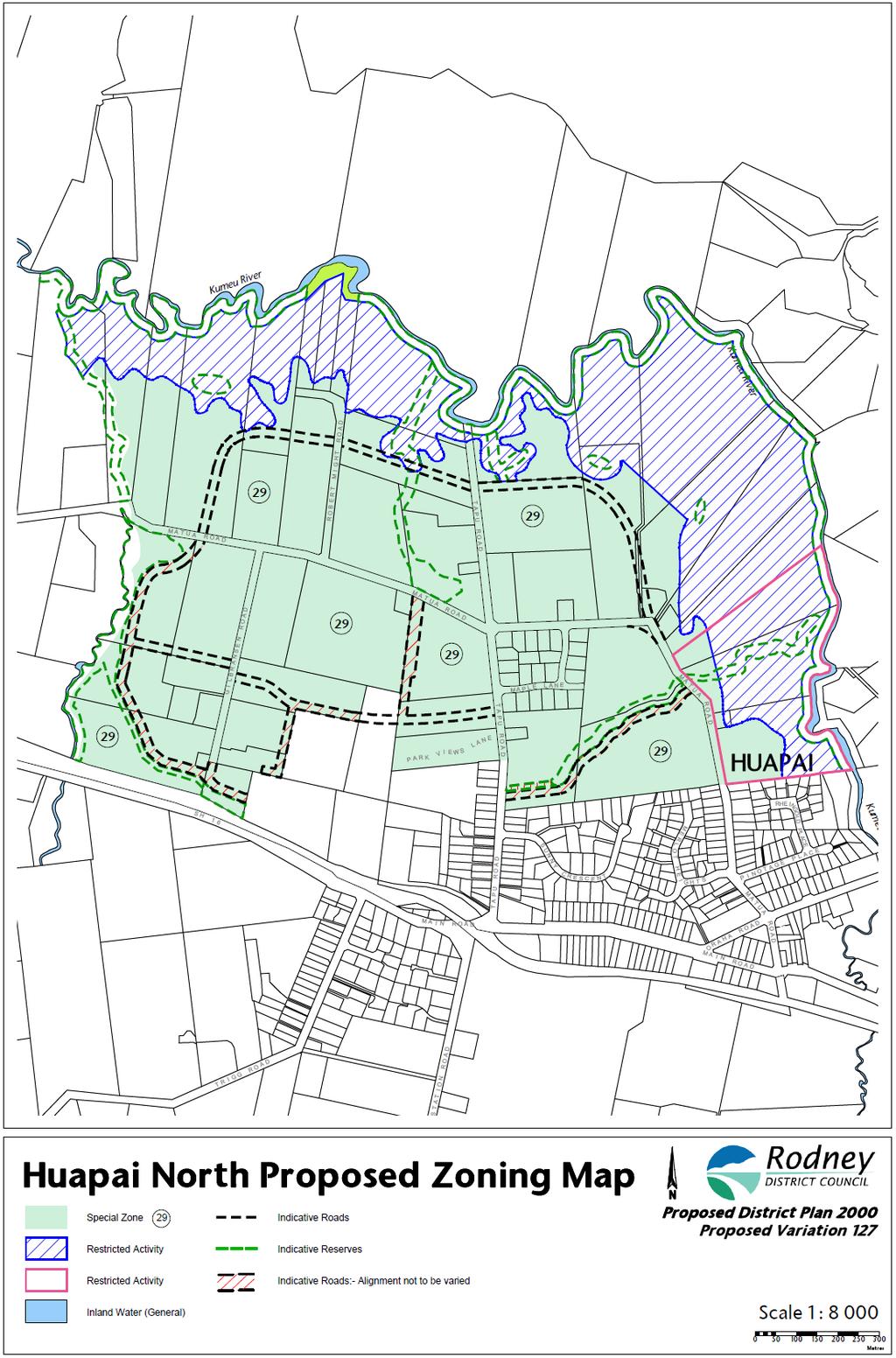
128
129 Annexure 4
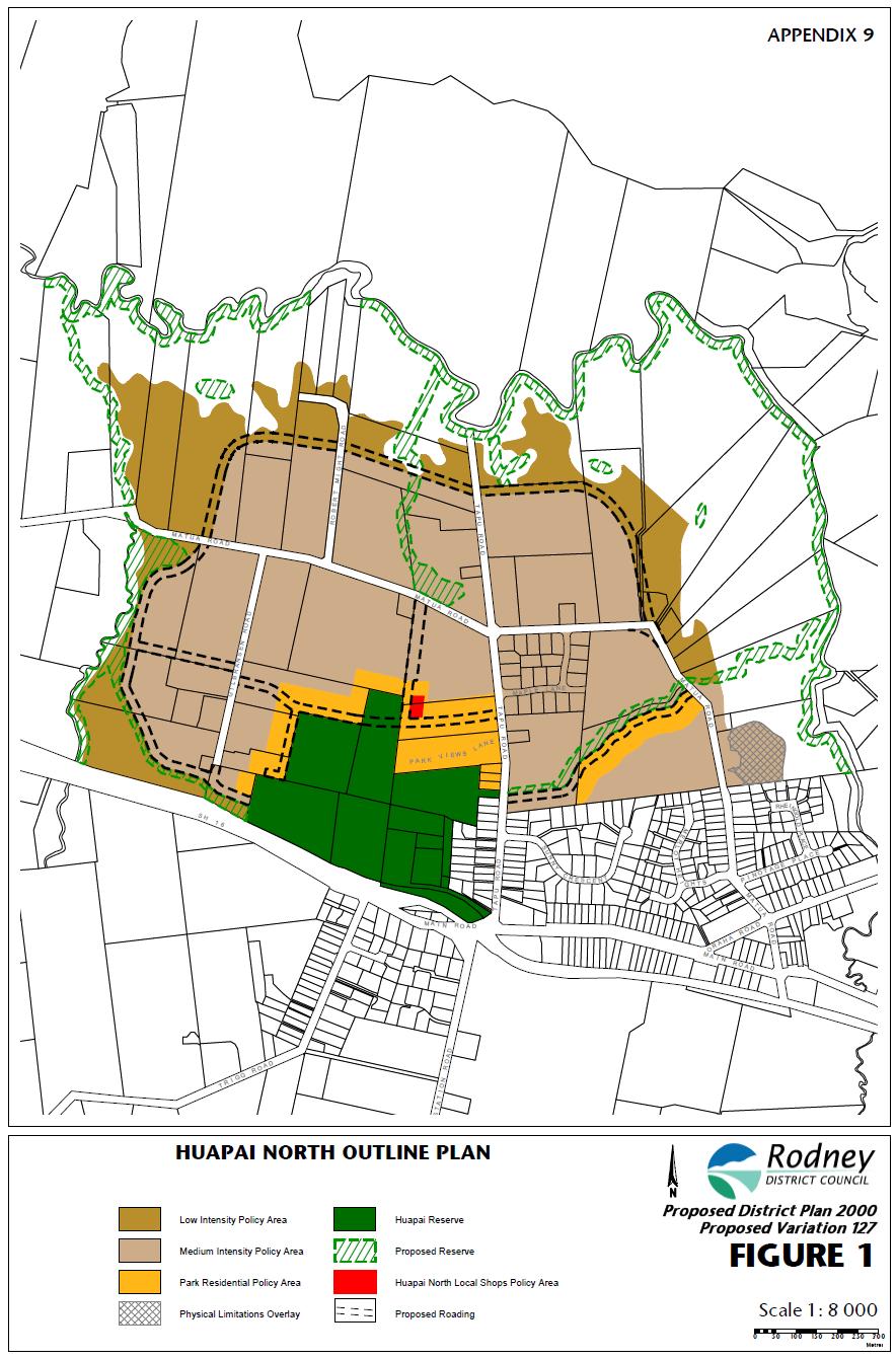
130
131 Annexure 5
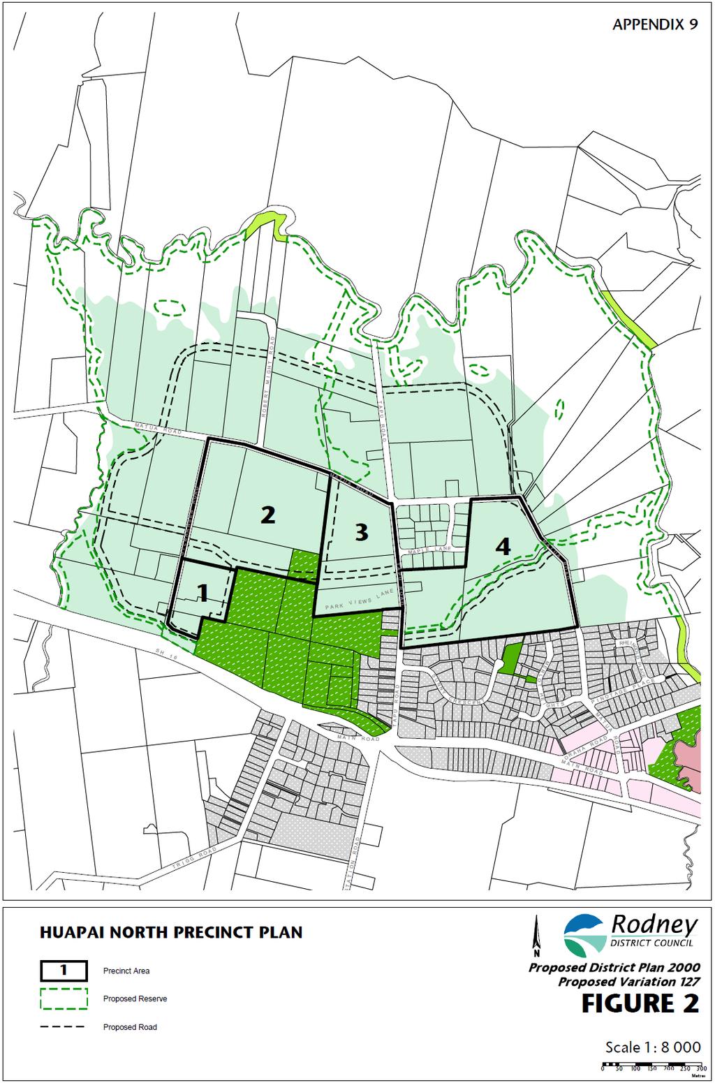
132
133 Annexure 6
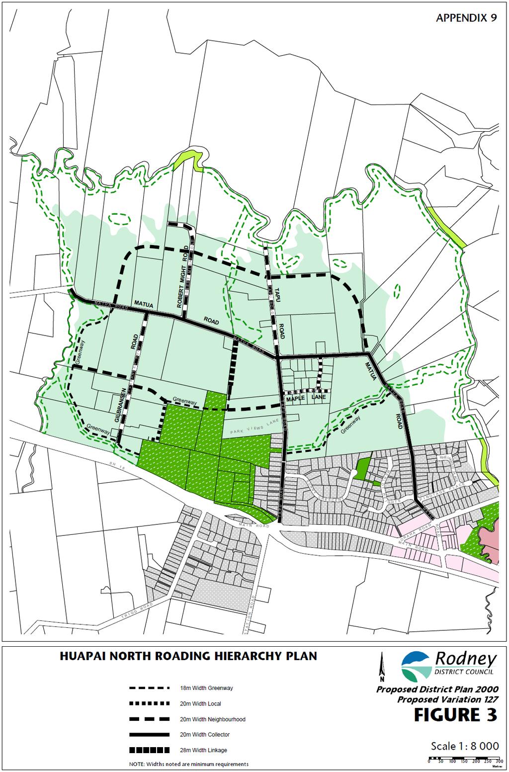
134
Tāhuhu whakaruruhau ā-taone The sheltering ridge pole
 B2. Tāhuhu whakaruruhau ā-taone - Urban growth and form B2.1. Issues Tāhuhu whakaruruhau ā-taone The sheltering ridge pole Auckland s growing population increases demand for housing, employment, business,
Plan Modification to Chapter B2 of the Auckland Unitary Plan(AUP) Operative in part (15 November 2016)
 Operative in part (15 November 2016)") UNITARY PLAN UPDATE REQUEST MEMORANDUM TO FROM Phill Reid Linley Wilkinson DATE 25 September 2018 SUBJECT Plan Modification to Chapter B2 of the Auckland Unitary Plan(AUP) Operative in part (15 November
UNITARY PLAN UPDATE REQUEST MEMORANDUM TO FROM Phill Reid Linley Wilkinson DATE 25 September 2018 SUBJECT Plan Modification to Chapter B2 of the Auckland Unitary Plan(AUP) Operative in part (15 November
I611. Swanson North Precinct
 I611. Swanson North Precinct I611.1. Precinct Description Swanson North is located in the north eastern foothills of the Waitakere Ranges. It is outside the Waitakere Ranges Heritage Area Act and the Waitakere
13 FUTURE DEVELOPMENT AND STRUCTURE PLANS
 13 FUTURE DEVELOPMENT AND STRUCTURE PLANS Contents 13.1 Introduction 13.2 Resource Management Issues 13.3 Objectives 13.4 Policies 13.5 Strategy 13.6 Implementation 13.6.1 District Plan Regulatory Methods
I539. Smales 2 Precinct
 I539. Smales 2 Precinct I539.1. Precinct Description The Smales 2 Precinct applies to a 4.8 hectare block of land located on the southern side of Northcote Road and fronting Lake Pupuke, Takapuna. The
SECTION 7A: WHAKARONGO RESIDENTIAL AREA
 SECTION 7A: WHAKARONGO RESIDENTIAL AREA CONTENTS 7A.1 Introduction 1 7A.2 Resource Management Issues 1 7A.3 Objectives and Policies 1 7A.4 Methods 4 7A.5 Residential Zone 4 7A.5.1 Rules: Controlled Activities
I403 Beachlands 1 Precinct
 I403. Beachlands 1 I403.1. Precinct Description Beachlands is a rural and coastal village located on the eastern side of Auckland, adjoining the Tamaki Strait coastline. The original Beachlands village
Appendix 1 Structure plan guidelines
 Appendix 1 Structure plan guidelines This appendix forms part of the regional policy statement [rps]. 1.1. Introduction Structure plans are an important method for establishing the pattern of land use
I602. Birdwood Precinct
 I602. Birdwood Precinct I602.1. Precinct description The Birdwood Precinct applies to an area west of Don Buck Road and south of Red Hills Road in west Auckland. It incorporates subdivision and development
Section 12C Subdivision in the Rural Residential Zone
 Section 12C 12C Subdivision in the Rural Residential Zone The Rural Residential Zone provides part of the range of residential opportunities within the City. Land zoned rural residential is considered
I615. Westgate Precinct
 I615. Westgate Precinct I615.1. Precinct Description The Westgate Precinct is located approximately 18km west of the Auckland city centre. There are seven Sub-precincts in the Westgate Precinct: Sub-precinct
4 RESIDENTIAL ZONE. 4.1 Background
 4 RESIDENTIAL ZONE 4.1 Background The residential areas within the City are characterised by mainly lowrise dwellings sited on individual allotments. Past architectural styles, settlement patterns and
QUEENSTOWN LAKES DISTRICT COUNCIL SUBDIVISION DESIGN GUIDELINES
 Attachment C: Draft QLDC Subdivision Design Guidelines QUEENSTOWN LAKES DISTRICT COUNCIL DESIGN GUIDELINES A DESIGN GUIDE FOR AND DEVELOPMENT IN THE URBAN ZONES QUEENSTOWN OFFICE 10 Gorge Road Queenstown
2A District-wide Policies
 2A Introduction This Chapter contains policies which are relevant to subdivision, use and development activities occurring across all zones and areas of the District. The policies in this Chapter implement
SPECIAL 35 (HIBISCUS COAST GATEWAY) ZONE
 ZONE") `` 12.8.35 SPECIAL 35 (HIBISCUS COAST GATEWAY) ZONE 12.8.35.1 Issues The following provisions relate to the Hibiscus Coast Gateway Zone. This zone is located at Silverdale in the area bounded by State
`` 12.8.35 SPECIAL 35 (HIBISCUS COAST GATEWAY) ZONE 12.8.35.1 Issues The following provisions relate to the Hibiscus Coast Gateway Zone. This zone is located at Silverdale in the area bounded by State
12 Subdivision, Services and Infrastructure
 12 Subdivision, Services and Infrastructure Section 12A 12A Purpose of Subdivision Provisions... 1 12A.1 General Subdivision Objectives and Policies... 2 12A.2 Activity Status Rules... 4 12A.3 General
Section 3b: Objectives and Policies Rural Environment Updated 19 November 2010
 Page 1 of Section 3b 3b RURAL ENVIRONMENT 3b.1 Introduction The Rural Environment comprises all the land outside of the Residential, Town Centre and Industrial Environments. Most land within the District
RURAL ZONE - POLICY. Rural Zone Policy. Issue: Rural Environment. Ruapehu District Plan Page 1 of 8
 Rural Zone Policy RU2 RURAL ZONE - POLICY RU2.1 Introduction The natural resources of the rural environment in the Ruapehu District provide the basis for the existing and potential character, intensity
4 Residential and Urban Living Zones
 4 Residential and Urban Living Zones Refer to Chapters 11 to 20 for additional rules that may apply to these zones. 4.1 OBJECTIVES AND POLICIES Objective Res1 Policy 1 Policy 2 Policy 3 Policy 4 Policy
H7 Open Space zones. (a) provide for the needs of the wider community as well as the needs of the community in which they are located;
 provide for the needs of the wider community as well as the needs of the community in which they are located;") H7. Open Space zones H7.1. Background The majority of land zoned as open space is vested in the Council or is owned by the Crown. However some areas zoned open space are privately owned. While the open
H7. Open Space zones H7.1. Background The majority of land zoned as open space is vested in the Council or is owned by the Crown. However some areas zoned open space are privately owned. While the open
64 Mineral Extraction Area Rules
 64 Mineral Extraction Area Rules 64.1 Introduction For the purposes of this Chapter: Active Area, in relation to a Mineral Extraction Area (MEA), is that part of the Mineral Extraction Area which is owned
Subdivision and Development
 Subdivision and Development 8.0 Introduction - Subdivision and Development The principle purpose of subdivision is to provide a framework for land ownership so that development and activities can take
11.3 SPECIAL CHARACTER ZONE HAWKE S BAY REGIONAL SPORTS PARK
 11.3 SPECIAL CHARACTER ZONE HAWKE S BAY REGIONAL SPORTS PARK 11.3.1 INTRODUCTION The availability of sports and recreation activities and facilities is important for the maintenance and enhancement of
Rural (Urban Expansion) Environment
 Environment") RUEE.1 Rural (Urban Expansion) Environment Subsequent to the receipt of appeals, a 'marked up' version of the Proposed District Plan was prepared. The provisions of the Proposed Version of the Plan subject
RUEE.1 Rural (Urban Expansion) Environment Subsequent to the receipt of appeals, a 'marked up' version of the Proposed District Plan was prepared. The provisions of the Proposed Version of the Plan subject
I609. Penihana North Precinct
 I609. Penihana North Precinct I609.1. Precinct description The Penihana North Precinct is located south of the Swanson Railway Station, adjacent to the Rural Urban Boundary (RUB) and Waitakere Ranges Heritage
THREE PARKS ZONE Three Parks Special Zone The process of applying for resource consents in the zone.
 .25 Three Parks Special Zone The purpose of this zone is to provide for growth and to give effect to the Wanaka 2020 Community (2002) and the more recent Wanaka Structure (2007) and Wanaka Transport Strategy
Rural (Urban Expansion) Environment
 Environment") RUEE.1 Rural (Urban Expansion) Environment Index RUEE.1 RUEE.1.1 RUEE.1.2 RUEE.1.3 RUEE.1.4 RUEE.2 RUEE.2.1 RUEE.2.2 RUEE.2.3 RUEE.2.4 RUEE.3 Rural (Urban Expansion) Environment Description and Expectations
RUEE.1 Rural (Urban Expansion) Environment Index RUEE.1 RUEE.1.1 RUEE.1.2 RUEE.1.3 RUEE.1.4 RUEE.2 RUEE.2.1 RUEE.2.2 RUEE.2.3 RUEE.2.4 RUEE.3 Rural (Urban Expansion) Environment Description and Expectations
15 Rural Residential Zone
 15 Rural Residential Zone Section 15A 15A Purpose of the Rural Residential Zone... 1 15A.1 Objectives and Policies of the Rural Residential Zone... 1 15A.2 Activity Status Rules... 5 15A.3 Permitted Activity
NORTH EAST INDUSTRIAL ZONE
 SECTION 12A: NORTH EAST INDUSTRIAL ZONE CONTENTS 12A.1 Introduction 1 12A.2 Resource Management Issues 2 12A.3 Objectives and Policies 3 12A.4 Rules: Permitted Activities 8 R12A.4.1 Permitted Activities
Section 12B 12B Subdivision in Residential Zones
 Section 12B 12B Subdivision in Residential Zones The Residential Zones provide for a range of infill and greenfield living opportunities across the City for the community to accommodate current and future
Ensure that development within the Arrowtown Urban Growth Boundary provides:
 URBAN DEVELOPMENT 4 4.2.5.2 Ensure that development within the Arrowtown Urban Growth Boundary provides: an urban form that is sympathetic to the character of Arrowtown, including its scale, density, layout
1. Assessment of Environmental Effects
 1. Assessment of Environmental Effects Table of Contents 1. Introduction and Overview 1 2. Statutory Assessment 3 3. Site Description 5 4. Proposal Description 7 5. Assessment of Effects on the Environment
Section Three, Part 16 Takanini Structure Plan Area
 PART 16 TAKANINI STRUCTURE PLAN AREA 16.1 Residential 8 zone 16.1.1 Objectives and Policies 16.1.2 Rules: General 16.1.3 Rules: Activity Status Subdivision (Except within the Addison Neighbourhood Centre)
Section 6A 6A Purpose of the Natural Features and Landscapes Provisions
 Section 6A 6A Purpose of the Natural Features and Landscapes Provisions This Chapter addresses the protection and management of natural features and landscapes within the City. The City has a number of
I412. Flat Bush Precinct
 I412. Flat Bush Precinct I412.1. Precinct description The Flat Bush precinct covers approximately 1730ha of land adjacent to the Rural Urban Boundary. The Flat Bush Precinct incorporates the provisions
H1. Residential Large Lot Zone
 H1. Residential Large Lot Zone H1.1. Zone description The Residential Large Lot Zone provides for large lot residential development on the periphery of urban areas. Large lot development is managed to
I209 Quay Park Precinct
 I209. Quay Park I209.1. Precinct description The Quay Park Precinct is located on reclaimed land at the eastern end of the city centre and along the City Centre waterfront. It is dissected to the east
REMARKABLES PARK ZONE
 .10 Remarkables Park Zone.10.1 Resources, Activities and Values The Remarkables Park Area comprises approximately 150 hectares of perimeter urban land in the vicinity of Frankton and occupies a strategic
PRIVATE PLAN CHANGE REQUEST REZONING OF LAND AT 49, 57 AND 71 MILL ROAD FROM RURAL 3 ZONE TO MAIN RESIDENTIAL ZONE. Amendments to:
 PRIVATE PLAN CHANGE REQUEST REZONING OF LAND AT 49, 57 AND 71 MILL ROAD FROM RURAL 3 ZONE TO MAIN RESIDENTIAL ZONE Amendments to: MANUKAU OPERATIVE DISTRICT PLAN 2002 AUCKLAND REGIONAL POLICY STATEMENT
Chapter 3: Natural Environment. Proposed Waikato District Plan Stage 1. (Notified version)
") Chapter 3: Natural Environment Proposed Waikato District Plan Stage 1 Page 2 of 7 Contents Chapter 3: Natural Environment... 3 3.1 Indigenous Vegetation and Habitats... 3 3.1.1 Objective Biodiversity and
Chapter 3: Natural Environment Proposed Waikato District Plan Stage 1 Page 2 of 7 Contents Chapter 3: Natural Environment... 3 3.1 Indigenous Vegetation and Habitats... 3 3.1.1 Objective Biodiversity and
9 BUSINESS. Contents. 9.1 Introduction Description of Business Activities Trends in Business Activity. 9.2 Resource Management Issues
 9 BUSINESS Contents 9.1 Introduction 9.1.1 Description of Business Activities 9.1.2 Trends in Business Activity 9.2 Resource Management Issues 9.3 Objectives 9.4 Policies 9.5 Strategy 9.6 Implementation
The Proposed Auckland Unitary Plan (notified 30 September 2013)
") 3 Business zones Introduction There are 10 business zones in the Unitary Plan: City Centre Metropolitan Centre Town Centre Local Centre Neighbourhood Centre Mixed Use General Business Business Park Light
3 Business zones Introduction There are 10 business zones in the Unitary Plan: City Centre Metropolitan Centre Town Centre Local Centre Neighbourhood Centre Mixed Use General Business Business Park Light
Northern Territory Compact Urban Growth Policy
 Northern Territory Compact Urban Growth Policy A Reference Policy Document to clause 2.7 (Reference to Policy) of the NT Planning Scheme May 2015 Table of Contents 1 Policy Setting... 3 1.1 Context for
HOROWHENUA DEVELOPMENT PLAN June create a safe crossing for children moving to and from the school and other areas. 7.8 Ohau
 7.8 Ohau create a safe crossing for children moving to and from the school and other areas. Ohau has a traditional village form with a collective of school, church and reserve at the main road intersection.
H14. Business General Business Zone
 H14. Business General Business Zone H14.1. Zone description The Business General Business Zone provides for business activities from light industrial to limited office, large format retail and trade suppliers.
H10. Business Town Centre Zone
 H10. Business Town Centre Zone H10.1. Zone description The Business Town Centre Zone applies to suburban centres throughout Auckland, the satellite centres of Warkworth and Pukekohe, and the rural towns
subdivision GUIDELINES TO THE RULES
 This section updated September 2013 GUIDELINES TO THE RULES This part of the Plan contains rules relating to the of land. Other rules in the Plan also need to be referred to, including the following: The
Appendix A. Planning Processes. Introduction
 1 Planning Processes Introduction This appendix outlines a number of planning processes which are used in the Auckland Region to support the effective management of development in the region s rural and
AOTEA SUPERMARKET ZONE. Zone Introduction
 C18 AOTEA SUPERMARKET ZONE Zone Introduction C18.1 Objective This zone identifies a specific area in Aotea for a stand alone supermarket. The zone is site specific and has a range of objectives, policies
54.18 DRURY SOUTH STRUCTURE PLAN AREA
 54.18 DRURY SOUTH STRUCTURE PLAN AREA 54.18.1 CONTEXT The Drury South Structure Plan Area has been identified as a logical location in the southern sector of the Auckland region for addressing part of
Proposed Kapiti Coast District Plan
 5 This Chapter primarily implements Objectives 2.1 Tāngata Whenua, 2.3 Development Management, 2.11 Character and Amenity Values, and 2.12 Housing Choice and Affordability as set out in Chapter 2. The
PINE HARBOUR MARINA ZONE PLAN CHANGE NO
 PINE HARBOUR MARINA ZONE PLAN CHANGE NO. 34 TO THE AUCKLAND COUNCIL DISTRICT PLAN (MANUKAU SECTION) PURSUANT TO THE FIRST SCHEDULE TO THE RESOURCE MANAGEMENT ACT 1991 1 REPLACE Planning Map No. 57 with
Proposed Southland District Plan 2012 Appeal Version October 2016
 S e c t i o n 3. 5 - F i o r d l a n d / R a k i u r a Z o n e The Fiordland/Rakiura Zone encompasses the Fiordland and Rakiura National Parks and part of Mt Aspiring National Park. It also includes areas
SECTION 2.4 URBAN DEVELOPMENT AND STRATEGIC URBAN DIRECTIONS
 SECTION 2.4 URBAN DEVELOPMENT AND STRATEGIC URBAN DIRECTIONS 2.4.1 INTRODUCTION In 1993/94 the Hastings District Council completed the Hastings Urban Development Strategy. The purpose of this study was:
H9. Business Metropolitan Centre Zone
 H9. Business Metropolitan Centre Zone H9.1. Zone description The Business Metropolitan Centre Zone applies to centres located in different subregional catchments of Auckland. These centres are second only
Subdivision Design Criteria. Penihana North GUIDELINES TO THE RULES
 Created September 2013 Penihana North Subdivision Design Criteria GUIDELINES TO THE RULES This part of the Plan sets out the design criteria for subdivision in Penihana North. The criteria will be considered
open space environment
 This section updated August 09 GUIDELINE TO THE RULES The Open Space Environment Rules apply to activities on sites within the Open Space Environment as shown on the Human Environments Maps. Most of the
OFFICE CONSOLIDATION SECONDARY PLAN AREA 22 THE BRAMALEA SOUTH INDUSTRIAL SECONDARY PLAN
 OFFICE CONSOLIDATION SECONDARY PLAN AREA 22 THE BRAMALEA SOUTH INDUSTRIAL SECONDARY PLAN November 2010 EXPLANATORY NOTES (Secondary Plan Area 22) General (pertaining to all secondary plan office consolidations)
Chapter Pine Harbour Marina Page 1
 Chapter 17.15 Pine Harbour Marina Page 1 Chapter 17.15 Pine Harbour Marina 17.15.1 Introduction Pine Harbour Marina (Pine Harbour) at Beachlands was established following a planning application in 1985
Section Three, Appendix 16C Medium Density Housing, Design Assessment Criteria (Residential 8A zone)
") APPENDIX 16C MEDIUM DENSITY HOUSING, DESIGN ASSESSMENT CRITERIA (RESIDENTIAL 8A ZONE) PURPOSE OF APPENDIX 16C (RESIDENTIAL 8A ZONE) In the Residential 8A Zone the following are defined as restricted discretionary
APPENDIX 16C MEDIUM DENSITY HOUSING, DESIGN ASSESSMENT CRITERIA (RESIDENTIAL 8A ZONE) PURPOSE OF APPENDIX 16C (RESIDENTIAL 8A ZONE) In the Residential 8A Zone the following are defined as restricted discretionary
4 OVERVIEW. Contents. 4.1 Introduction. 4.2 Profile of the Rodney District Location The People Function of Places
 4 OVERVIEW Contents 4.1 Introduction 4.2 Profile of the Rodney District 4.2.1 Location 4.2.2 The People 4.2.3 Function of Places 4.3 Rodney District in the Regional Context 4.3.1 Rodney District 4.3.2
RLE.1 Rural Living Environment
 Index.1 Description and Expectations.2 Objectives.3 Policies.4 Guidance RLE.2 Landuse RLE.2.1 Eligibility Rules RLE.2.2 Notification Rules RLE.2.3 Discretionary Activities RLE.3 Subdivision RLE.3.1 Eligibility
PART AOTEA PRECINCT
 CONTENTS... PAGE AOTEA PRECINCT...4 14.5.1 INTRODUCTION...4 14.5.2 RESOURCE MANAGEMENT ISSUES...4 14.5.3 RESOURCE MANAGEMENT OBJECTIVES AND POLICIES... 4 14.5.4 RESOURCE MANAGEMENT STRATEGY...5 14.5.5
Section Three, Appendix 17C Multiple Unit Housing Design Assessment Criteria
 APPENDIX 17C MULTIPLE UNIT HOUSING DESIGN ASSESSMENT CRITERIA Purpose of Appendix 17C In the Residential 9 Zone the construction and use of multiple household units located within the Multiple Household
Guidance Notes Completing an AEE
 Guidance Notes Completing an AEE The purpose of this guidance note is to assist you with completing your Assessment of Environmental Effects (AEE) for your land-use consent application. If you do not provide
I422. Māngere Gateway Precinct
 I422. Māngere Gateway Precinct I422.1. Precinct description The Māngere Gateway Precinct is comprised of land generally north of the Auckland International Airport and west of George Bolt Memorial Drive
I604. Hobsonville Marina Precinct
 I604. Hobsonville Marina Precinct I604.1. Precinct description Hobsonville Marina Precinct is located at Clearwater Cove, Hobsonville in Auckland s upper Waitemata Harbour. The precinct includes the coastal
H13. Business Mixed Use Zone
 H13. Business Mixed Use Zone H13.1. Zone description The Business Mixed Use Zone is typically located around centres and along corridors served by public transport. It acts as a transition area, in terms
SCHEDULE 10 TO THE URBAN GROWTH ZONE. Shown on the planning scheme map as UGZ10. Truganina Precinct Structure Plan. 1.0 The Plan
 SCHEDULE 10 TO THE URBAN GROWTH ZONE Shown on the planning scheme map as UGZ10 Truganina Precinct Structure Plan 1.0 The Plan Map 1 shows the future urban structure proposed in the Truganina Precinct Structure
SUSTAINABLE MANAGEMENT
 . Sustainable Management.1 The Concept of Sustainable Management The concept of sustainable management recognises there are limits to the use of natural and physical resources and there is a need to balance
6 PORT SYDNEY SETTLEMENT AREA
 Section 6 Port Sydney Page 61 6 PORT SYDNEY SETTLEMENT AREA 6.1 Basis and Principles Village of Port Sydney Waterfront Community Existing Services 6.1.1 Port Sydney is an historic settlement that has developed
Planning Proposal Toronto Road, Booragul. Amendment to Lake Macquarie Local Environmental Plan (LMLEP) 2014
 2014") Planning Proposal Toronto Road, Booragul Amendment to Lake Macquarie Local Environmental Plan (LMLEP) 2014 Local Government Area: Name of Draft LEP: Subject Land: Land Owner: Applicant: Folder Number:
Planning Proposal Toronto Road, Booragul Amendment to Lake Macquarie Local Environmental Plan (LMLEP) 2014 Local Government Area: Name of Draft LEP: Subject Land: Land Owner: Applicant: Folder Number:
Chapter 13 Residential Areas: Appendices APPENDIX 1 Residential Areas
 Chapter 13 Residential Areas: Appendices Page 1 Chapter 13 Residential Areas: Appendices APPENDIX 1 Residential Areas Design Code for Intensive Housing INTRODUCTION DESIGN ELEMENTS A NEIGHBOURHOOD DESIGN
GIBBSTON CHARACTER ZONE. QLDC PROPOSED DISTRICT PLAN [PART FOUR] AUGUST gibbston character zone
![GIBBSTON CHARACTER ZONE. QLDC PROPOSED DISTRICT PLAN [PART FOUR] AUGUST gibbston character zone](/thumbs/75/72573993.jpg "GIBBSTON CHARACTER ZONE. QLDC PROPOSED DISTRICT PLAN [PART FOUR] AUGUST gibbston character zone") 23 GIBBSTON CHARACTER ZONE QLDC PROPOSED DISTRICT PLAN [PART FOUR] AUGUST 2015 23 gibbston character zone QLDC PROPOSED DISTRICT PLAN [PART FOUR] AUGUST 2015 23 gibbston character zone 23.1 Zone Purpose
23 GIBBSTON CHARACTER ZONE QLDC PROPOSED DISTRICT PLAN [PART FOUR] AUGUST 2015 23 gibbston character zone QLDC PROPOSED DISTRICT PLAN [PART FOUR] AUGUST 2015 23 gibbston character zone 23.1 Zone Purpose
PUBLIC NOTICE UNDER CLAUSE 5 OF SCHEDULE 1 OF THE RESOURCE MANAGEMENT ACT 1991 PLAN CHANGE 12 TO THE OPERATIVE CITY OF NAPIER DISTRICT PLAN
 PUBLIC NOTICE UNDER CLAUSE 5 OF SCHEDULE 1 OF THE RESOURCE MANAGEMENT ACT 1991 PLAN CHANGE 12 TO THE OPERATIVE CITY OF NAPIER DISTRICT PLAN Public notice is given in accordance with Clause 5 of Schedule
What progress have we made so far? NEWSLETTER PROPOSED IONA RESIDENTIAL DEVELOPMENT UPDATE
 MAY 2017 NEWSLETTER PROPOSED IONA RESIDENTIAL DEVELOPMENT UPDATE The Iona Working Group has been set up to encourage discussions between the parties involved in the Environment Court Process. This newsletter
and services The protection and conservation of environmentally significant and sensitive natural heritage features and functions.
 6. Land Use 6.0 Preamble A healthy and livable city is one in which people can enjoy a vibrant economy and a sustainable healthy environment in safe, caring and diverse neighbourhoods. In order to ensure
INCREMENTAL CHANGE AREA REVIEW March 2015 Page 1
 INCREMENTAL CHANGE AREA REVIEW March 2015 Page 1 Table of Contents Introduction... 3 Background to Review... 3 Comparison of the Schedules to the General Residential Zone... 7 Methodology... 7 Policy Context...
COMMUNITY DESIGN. GOAL: Create livable and attractive communities. Intent
 COMMUNITY DESIGN Intent An attractive, well-designed County will attract quality development, instill civic pride, improve the visual character of the community, and create a strong, positive image for
FORMER CANADIAN FORCES BASE (CFB) ROCKCLIFFE SECONDARY PLAN. Official Plan Amendment XX to the Official Plan for the City of Ottawa
 ROCKCLIFFE SECONDARY PLAN. Official Plan Amendment XX to the Official Plan for the City of Ottawa") FORMER CANADIAN FORCES BASE (CFB) ROCKCLIFFE SECONDARY PLAN Official Plan Amendment XX to the Official Plan for the City of Ottawa 1 INDEX THE STATEMENT OF COMPONENTS PART A THE PREAMBLE PAGE Purpose...
FORMER CANADIAN FORCES BASE (CFB) ROCKCLIFFE SECONDARY PLAN Official Plan Amendment XX to the Official Plan for the City of Ottawa 1 INDEX THE STATEMENT OF COMPONENTS PART A THE PREAMBLE PAGE Purpose...
Road transport activities and infrastructure can have adverse effects on the environment and community.
 22 Road Transport 22.1 Significant Issues Road transport activities and infrastructure can have adverse effects on the environment and community. Land use activities can have adverse effects on the safety
Draft Ada Street Cardiff Area Plan
 Draft Ada Street Cardiff Area Plan (Draft Amendment to Lake Macquarie Development Control Plan 2014) Exhibition: The draft Area Plan is on public exhibition from 29 February 2016 to 29 March 2016. Submissions:
Mark-up of the effect of the proposed Bronte Village Growth Area OPA No.18 on the text of section 24, Bronte Village, of the Livable Oakville Plan
 Mark-up of the effect of the proposed Bronte Village Growth Area OPA No.18 on the text of section 24, Bronte Village, of the Livable Oakville Plan Notes: This document is provided for information purposes
AMENDMENTS. Date Effective. Amendment No. Council. DCP 14 Davidson St, Greenacre Page 2
 AMENDMENTS Amendment No. Description Adopted by Council Date Effective DCP 14 Davidson St, Greenacre Page 2 TABLE OF CONTENTS 1.0 INTRODUCTION... 4 1.1 NAME OF THIS PLAN... 4 1.2 COMMENCEMENT OF DEVELOPMENT
Draft Housing Choice and Supply Plan Change for Tawa and Karori Released for informal consultation Nov 2015
 Housing Choice & Supply Draft Amendments to the District Plan (Additions shown in underline, deletions are shown as strikethrough) 1. Include 2 new definitions as follows (Chapter 3: Definitions): RETIREMENT
Contents of Part 6. Part 6 Zones
 Contents of Part 6 Part 6 Zones... 6-1 6.1 Preliminary... 6-1 6.2 Zone codes... 6-3 6.2.1 Low density residential zone code... 6-3 6.2.1.1 Application... 6-3 6.2.1.2 Purpose and overall outcomes... 6-3
I333 Three Kings Precinct
 I333. Three Kings I333.1. Precinct description The Three Kings Precinct provides for the development of a vibrant, sustainable urban village on the former quarries and the adjacent land at Three Kings.
SCHEDULE THREE TO THE DEVELOPMENT PLAN OVERLAY EASTERN GOLF COURSE KEY REDEVELOPMENT SITE
 DD/MM/YY SCHEDULE THREE TO THE DEVELOPMENT PLAN OVERLAY Shown on the planning scheme map as DPO3 EASTERN GOLF COURSE KEY REDEVELOPMENT SITE 1.0 A permit may be granted before a development plan has been
Part 12 Precinct Area Plans - Wyee West
 TABLE OF CONTENTS 1 INTRODUCTION... 1 1.1 BACKGROUND... 1 1.2 EXTENT OF AREA PLAN... 1 1.3 EXISTING CHARACTER... 2 1.4 ENVIRONMENTAL ATTRIBUTES AND CONSTRAINTS... 2 1.5 DESIRED FUTURE CHARACTER... 3 1.6
18 Industrial Zones. Section 18A. Appendices
 18 Industrial Zones Section 18A 18A Purpose of the Industrial Zones... 1 18A.1 Purpose of the Industry Zone... 1 18A.2 Purpose of the Port Industry Zone... 1 18A.3 Purpose of the Tauriko Industry Zone...
Planning Proposal Concurrent DA/LEP Amendment for Belmont North Pharmacy Amendment No. 24 to Lake Macquarie Local Environmental Plan (LMLEP) 2014
 2014") Planning Proposal Concurrent DA/LEP Amendment for Belmont North Pharmacy Amendment No. 24 to Lake Macquarie Local Environmental Plan (LMLEP) 2014 Local Government Area: Name of Draft LEP: Subject Land:
Planning Proposal Concurrent DA/LEP Amendment for Belmont North Pharmacy Amendment No. 24 to Lake Macquarie Local Environmental Plan (LMLEP) 2014 Local Government Area: Name of Draft LEP: Subject Land:
I542. Te Arai South Precinct
 I542. Te Arai South Precinct I542.1. Precinct Description The Te Arai South Precinct contains approximately 750ha of coastal land south of Te Arai Point, known as Mangawhai South Forest. The land within
CA.1 Coastal Area. Index. CA.1.1 Description and Expectations
 Index.1.2.3.4 CA.2 CA.2.1 CA.2.2 CA.2.3 CA.3 CA.3.1 CA.3.2 CA.3.1 CA.4 CA.4.1 CA.4.2 CA.4.3 CA.4.4 CA.5 CA.5.1 CA.5.2 Description and Expectations Objectives Policies Guidance Note Landuse Eligibility
PNE Port Nikau Environment Rules. Index. Page 1 of 37
 PNE.50.1 Port Nikau Environment Index PNE.50.1 PNE.50.1 PNE.50.2 PNE.50.2.1 PNE.50.2.2 PNE.50.3 PNE.50.3.1 PNE.50.3.2 PNE.50.3.3 PNE.50.3.4 PNE.50.4 PNE.50.4.1 PNE.50.4.2 PNE.50.4.3 PNE.50.4.4 PNE.50.5
North Oakville East Parks Facilities Distribution Plan. November, 2009
 North Oakville East November, 2009 POLICY CONTEXT 1) Purpose a) The purpose of this document is to be a guide for the location, configuration, design and development of the parks system for the North Oakville
Complete Neighbourhood Guidelines Review Tool
 Complete Neighbourhood Guidelines Review Tool Prepared By: City of Regina Planning Department October 2014 Page 1 of 14 Community Development Review Checklist for Secondary Plans and Concept Plans The
HAMILTON CITY COUNCIL PROPOSED DISTRICT PLAN NOVEMBER 2001 (REFERENCES VERSION) Proposed Variation No.7: Temple View Rezoning
 Proposed Variation No.7: Temple View Rezoning") HAMILTON CITY COUNCIL PROPOSED DISTRICT PLAN NOVEMBER 2001 (REFERENCES VERSION) Proposed Variation No.7: Temple View Rezoning 1.0 Purpose of the Variation APPENDIX 1 On 1 July 2004 the Temple View area
HAMILTON CITY COUNCIL PROPOSED DISTRICT PLAN NOVEMBER 2001 (REFERENCES VERSION) Proposed Variation No.7: Temple View Rezoning 1.0 Purpose of the Variation APPENDIX 1 On 1 July 2004 the Temple View area
LANDSCAPE GUIDELINES. Countryside & Coastal Countryside Environments. Landscape, Natural Character & Amenity Values Guide
 Landscape, Natural Character & Amenity Values Guide Copyright WDC 2009 Version A2 18May09 Environmental Services Group Publication Countryside & Coastal Countryside Environments START HERE Quality Land
CONTENTS 8.0 LAND USE 8.1 GENERAL LAND USE 8.2 RESIDENTIAL 8.3 MIXED USE 8.4 COMMERCIAL 8.5 EMPLOYMENT LANDS
 8-2 Land Use 8.0 LAND USE CONTENTS 8.1 GENERAL LAND USE 8.1.1 Uses provided for in all Land Use Designations 8.1.2 Uses prohibited in Hazardous Lands, Hazardous Sites and Special Policy Areas 8.1.3 Uses
Appendix 18F: Tauriko Business Estate Services Strategy Statement and Sequencing Schedule
 Appendix 18F: Tauriko Business Estate Services Strategy Statement and Sequencing Schedule This statement describes key proposals for the development of infrastructure at Tauriko Business Estate. Appendix