Planning a Development in the District of Summerland
|
|
|
- Madison Allison
- 5 years ago
- Views:
Transcription


1


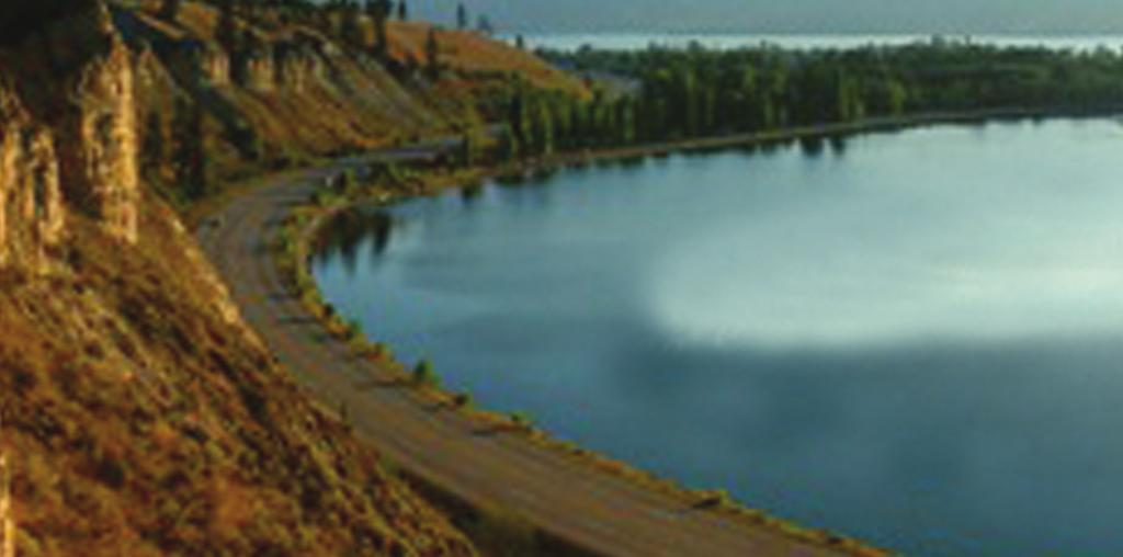
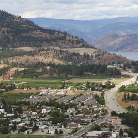
2 Planning a Development in the District of Summerland A Special Place Summerland enjoys beautiful lake views and abundant natural areas. As our valley s population grows, we want to maintain these natural assets so that future generations enjoy the same quality of life that we do now. The south Okanagan enjoys high property values and studies show that lots adjacent to protected open spaces, parks and recreation trails have % higher property and resale values. Our valley s natural and working landscapes are a very important asset, so by protecting them we are benefiting the community and ensuring the continuing value of real estate. Protecting our Natural Assets The District of Summerland is working to keep the natural environment protected. We have mapped and designated sensitive natural areas such as watercourses, grasslands, forests and wetlands, so you may be asked to complete an environmental assessment if your property occurs in one of these areas. Expenses and time associated with development approval can be reduced if you begin the planning process by considering environmental values. Protecting the environment can have lots of advantages Where to Start? Protecting sensitive natural environments is the responsibility of all levels of government - federal, provincial and municipal or regional. Find out which regulations apply to you and understand the approvals you need before you begin work. This will save you time and money in the long run. These regulations apply not only to where you build, but also how you build. If you are working in a sensitive area you may be asked to monitor the impact of excavation and construction and mitigate damage that can occur. Keep in mind that you can reduce the cost of land clearing and postconstruction landscaping by clearing a smaller portion of the property to be developed. Think About It - protecting the environment can have lots of advantages 1 faster planning approval reduced land clearing costs higher property values faster sales greater community buy-in and recognition protection of green space and wildlife a better development for everyone


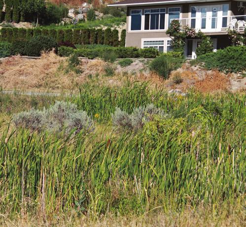
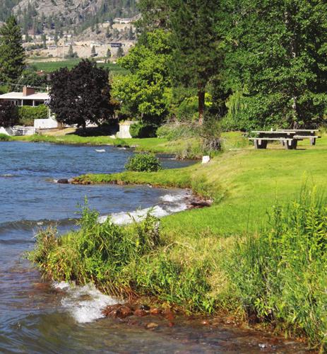
3 Natural Areas within the District of Summerland Summerland has a unique community character with its patchwork of orchards, vineyards, creeks, deep gullies and natural areas. It s up to all of us to achieve that special balance of natural and developed areas. Here s an introduction to some of the special habitats that are part of our municipality. Grasslands - Grasslands are the most common natural landscape in the Okanagan, with bunchgrass and sagebrush as the dominant plants. Nationally, grasslands are one of Canada s most endangered landscapes. More than half of our province s species at risk live in grasslands. This habitat has been heavily impacted by human development, so large, intact areas are very valuable. Invasive weeds that compete for space with native grasses and degrade the value of grasslands for wildlife have had a terrible impact on grassland. To prevent weeds getting established, stockpile topsoil and minimizing site disturbance during development. It s up to all of us to achieve that special balance of natural and developed areas Stream & River Bank Habitat - Also called riparian-areas, this habitat includes the water-loving plants and trees alongside lakes and rivers. Plants growing along streams and creeks provide shade to keep temperatures cool and are nursery grounds for fish like Kokanee. The roots of riverside plants keep the banks from eroding during floods and protect water quality by filtering surface water runoff. These ribbons of green habitat support a rich diversity of wildlife and are important wildlife corridors. If your property includes a riparian area, you will need to become familiar with the Riparian Areas Regulation, or RAR, that applies to your property when you begin planning for development. Lakes & Rivers - Summerland has three major rivers flowing into Okanagan Lake: Eneas Creek, Prairie Creek and Trout Creek. To help keep our waterways clean it is important to control sediments and chemicals from entering storm water, including runoff from fertilizers and pesticides. Our lakes and rivers provide the majority of our drinking water so human health is related to the health of our lakes and watercourses. If you are planning work such as building a dock or bridge within a water body, you must have a permit to conduct instream works under the Water Act. Wetlands - Wetlands are areas like ponds, cattail marshes and seasonally-flooded fields. These areas are full of life in the summer with birds, amphibians, and insects. In our dry climate, wetlands have always been rare and are disappearing at an alarming rate with development and climate change. If you have wetlands on your property where you are planning a development, you will be asked to make special provisions to protect these sensitive areas. Forests - Summerland has significant forested lands surrounding the more urban areas. Forests are critically important in stabilizing the soil along the steep valley walls of our valley, reducing erosion and sedimentation. They are also home to two thirds of Canada s plants and wildlife, including larger mammals. Last but not least, the woody debris under trees is home for a host of small reptiles, amphibians, mammals and insects. If you are planning work within a forested area, you may be required to protect and retain trees or conduct a wildlife tree survey. Rugged Cliffs - The rocky slopes and cliff talus that form the shoulders of our local mountains are an important wildlife corridor used in all seasons of the year. Many animals need to pass back and forth between the hillsides and the surrounding grasslands. If you property is near this terrain, consider protecting a wildlife corridor that provides access between the hills and the lower habitat areas. 2


4 Local Bylaws that Apply to Development The Official Community Plan contains many policies to guide Council decisions regarding conservation of natural areas and features. Check to see if your proposal respects the general intent of the Official Community Plan Objectives and Policies. How do you know if there are natural features to protect on your property? - When you are applying to rezone, subdivide or otherwise alter land, Summerland staff will use municipal mapping to identify if your property contains known Environmentally Sensitive Areas. To access Summerland municipal mapping site, go to: Environmentally Sensitive Area Protection & Regulation There are many plants, wildlife and ecosystems found in Summerland that are unique to this area. From the shores of Okanagan Lake to the steep rugged slopes of Giant s Head Park, the diversity in nature that we witness in Summerland is remarkable. In response to the increasing threats to, and rarity of, native plants, wildlife, and ecosystems, Summerland has undertaken a series of initiatives to protect and restore vital habitat. The diversity in nature that we witness in Summerland is remarkable Official Community Plan Bylaws Watercourse Development Permit Area (WDPA) requires landowners to apply for a permit before subdividing, construction, or altering the land. This development permit area is specifically designed to comply with the provincial Riparian Areas Regulation, under the provincial Fish Protection Act. Development within a WDPA requires that a Riparian Area Assessment be conducted by a Qualified Environmental Professional and has environmental guidelines to protect water quality and riparian habitat within 30m of all watercourses that support fish or fish habitat. Environmentally Sensitive Development Permit Area (ESDPA) requires landowners to apply for a permit before subdividing, construction, or altering the land. The purpose of this development permit is for protection, where possible, of sensitive ecosystems and rare and endangered plants, plant communities and wildlife. Development within an ESDPA requires an Environmental Assessment conducted by a registered professional biologist (RPBio) with experience working with local ecosystems, and may include other Qualified Environmental Professionals (QEPs). Zoning Bylaw 3 Current minimum setback for buildings and structures from the natural boundary of a watercourse is 30 metres.


5 Local Bylaws that Apply to Development Continued Earthworks Control Bylaw Applies to earthworks greater than 300 cubic meters in any twelve month period or an area more than 1200 square meters. A permit is subject to standards including: quality of all drainage leaving the site must meet or exceed the quality of drainage that was leaving the site prior to the commencement of the earthwork; prevent anything associated with earthwork that may damage or cause an obstruction to a watercourse; and, any damage that is caused to a watercourse due to earthworks must be repaired. Subdivision Bylaw Requires all subdivision developments to have a Drainage, Sediment, and Erosion Control Plan that will be used during the subdivision or development of the parcel. The Plan must be prepared in accordance with the Ministry of Environment s Land and Development Guidelines for the protection of aquatic habitat and the Urban Runoff Control Guideline for British Columbia. Developer must ensure that no silt, gravel or debris resulting from construction activity in the subdivision or development is allowed to discharge into existing drainage systems, natural drainage courses or watercourses. Conservation Covenants May be placed on part of a property to protect the designated area from future disturbance, as a result of a rezoning or subdivision application, or development permit. These covenants require the owner, and all future owners, to abide by the terms of the covenants to protect native vegetation and wildlife habitat. 4


?")
, Geoscientists (PGeo), Foresters (RPF), Agrologists (PAg), Professional Engineer (PEng) and Applied Science Technologist and Technicians")
6 Environmental Professionals For planning development within an Environmental or Watercourse Development Permit Area, you must engage an environmental professional early in your planning so that you can respond to their findings and incorporate their recommendations into your development design prior to the disturbance of the site. Take time to talk to several consultants about their expertise, availability, fees, and experience with the ecosystems in your area and the type of assessment that you need. For an environmental assessment, a Registered Professional Biologists must always be part of the team of professionals hired because of their expertise with local ecosystems and wildlife species. A good development plan that meets environmental requirements will progress much more quickly through the approval process and save you money in the long run. You must engage an environmental professional early in your planning What is a Qualified Environmental Professional (QEP)? - A QEP is an applied scientist or technologist, acting alone or together with another QEP. A QEP must be a member in good standing of a BC professional organization. The applicable professionals include Biologists (RPBios), Geoscientists (PGeo), Foresters (RPF), Agrologists (PAg), Professional Engineer (PEng) and Applied Science Technologist and Technicians (AScT). Working with a Qualified Environmental Professional will probably involve implementing mitigation measures for potential impacts from the planned development. Your QEP will likely use the sequence of mitigation options below to guide their assessment of the potential impacts that a proposed development will have. Most Preferred Avoid developing in or near identified Environmentally Sensitive Areas (ESAs) 5 Least Preferred Locate proposed development in pre-disturbed locations on the property Design development to include Alternative Development Standards or to avoid ESAs Mitigate to reduce potential impacts based on recommendations from the QEP Compensate as a final resort to achieve a no-net-loss of environmental values onsite


7 Best Practices for Developers Sustainable Development - Many municipalities are now assessing whether a development project contributes to community sustainability using the following guidelines as a measure. How well does the proposed development: Fit within growth areas outlined in the Official Community Plan and the South Okanagan Regional Growth Strategy Occur close to existing infrastructure without requiring costly expansion of roads, water, power, sewer, police and fire protection. Fit with surrounding agricultural areas and their necessary operations. Protect environmentally sensitive areas including streams, rivers and lakes. Conserve wildlife movement corridors between natural areas. Connect to existing parks, natural open spaces and pedestrian trails for enhanced recreational opportunities Add to community amenities Professionals should be hired at the beginning of your planning process, not the end Plan Ahead Sensitive, sustainable design begins with site planning. That is why qualified professionals should be hired at the beginning of your planning process, not the end. They can map out the natural features and find out whether any sensitive habitats are located on your property. Designing from a blank piece of paper is difficult. Designing from a map containing topography, natural features, existing structures, road networks and environmental values is much easier. This information allows professional designers to prepare efficient and supportable development plans. Design Before You Build: Locate buildings and roadways to preserve important natural areas on the property. Maintain natural wildlife corridors between your property and those adjacent to you in the surrounding area. Design stormwater systems that protect fish and aquatic habitat and plan for sediment and erosion control during construction. Use permeable paving and landscape surfaces and protect natural water flow patterns that affect nearby watercourses and wetlands. Pre-plan your construction footprint to minimize landscape disturbance and retain natural areas. (This can also save re-landscaping costs.) Stockpile native topsoil to redistribute after construction is over. Schedule the most invasive construction activities (such as clearing and blasting) during least risk to wildlife work windows. Locate buildings or driveways away from steep slopes to avoid erosion and loss of rugged grasslands or rocky outcrops. 6


8 Best Practices for Developers Continued After Construction Invasive weeds will colonize disturbed sites in only a few weeks. Make sure they are cleared away and disposed of appropriately. Design water efficient landscapes and irrigation systems using drought-tolerant and native plants Restore environmentally sensitive areas that might have been impacted by construction and consider fencing off designated non-disturbance areas The Water Challenge During the summer, homeowners use more then sixty percent of their domestic treated water for their lawns and gardens. With population increase, developers and homeowners are encouraged to adopt water saving standards - especially for irrigating lawns and landscaping. Planning new home landscapes using native and drought-tolerant plants (xeriscaping) and low-water use irrigation systems is good idea that will save money in the long-run. For advice on low-water landscaping consult Natural vegetation provides wildlife habitat and helps stabilize the lake edge Lakeshore Properties It is important for lakeside property owners to familiarize themselves with regulations regarding development and construction near lakes and other watercourses. Land below a lake s high water level belongs to the Crown so; all dock structures require authorization by one or more government agencies, including permissions for changes in and about a stream Retaining walls and groynes on Okanagan Lake have an impact on sedimentation and erosion of the surrounding shoreline whereas natural vegetation provides wildlife habitat and helps stabilize the lake edge. Replanting shorelines with small trees and vegetation is preferable to lawns which can contain herbicides and fertilizer.


9 Success Stories Protecting Sensitive Ecosystems & Species During Development Bighorn Mountain Estates, Okanagan Falls The Environmental Assessment identified rare Antelope-brush grassland, property use by California All the people that Bighorn Sheep and other species at risk. The developers avoided the environmentally sensitive areas by clustering development into a disturbed portion of the property (an old gravel pit). live here chose this Approximately 16 hectares of remaining land was donated to The Land Conservancy. The gated- area because they community design incorporates a cattle guard and snake proof barrier fencing to prevent conflicts love nature between domestic pets and wildlife. All the people that live here chose this area because they love nature. I can watch up to fourteen sheep, including adults and young, run down the cliff from my porch. We looked all over the South Okanagan until we found this place which just felt right. We are close to an urban area yet we are semi-rural. It s like being in a little piece of heaven. ~ Resident Summerland Waterfront Resort, Summerland Developers of Summerland Waterfront Resort were not required, but voluntarily protected, restored and enhanced the natural wetland and riparian area along the property shoreline. This included retaining and enhancing one of the few natural wetlands along the shores of Okanagan Lake. They now have wildlife observation and walking pathway for guests. Guest are presently surprised and delighted by the wildlife viewing and natural ambiance that this natural wetland brings General Manager 8


10 Conservation Options for Lands to be Developed Conservation Covenants Conservation covenants are voluntary legal agreements registered under Section 219 of the Land Title Act. A covenant can cover all or just a portion of a property to permanently protect specified natural or cultural features. The covenant places restrictions on land use and applies in perpetuity to the property title. local governments have the ability to issue tax exemptions for riparian areas Tax Benefits If the land protection is not required by the development permit, donations of land or conservation covenants can be treated as a charitable gift that is eligible for a tax receipt. The tax receipt can be used by individuals as a non-refundable tax credit or by corporations as a tax deduction. Placing a conservation covenant on a property may also result in a reduction in property taxes due to a lower assessed property value. In most provinces, a reduction in federal tax payable will also reduce provincial tax. Sometimes an outright donation of land to a local government or conservation organization can be simpler that a conservation covenant. Under Environment Canada s Ecological Gifts Program, the land must be certified as ecologically sensitive and appraised. Check out further information on Ecological Gifts at Both conservation covenants and the tax laws that apply are case specific and further legal advice should be sought. 9


11 Additional Resources The following information and free publications will help you learn about natural habitats and development guidelines to consider before you begin a land development project. 1. Develop with Care: Environmental Guidelines for Urban and Rural Land Development in British Columbia, published by BC Ministry of Environment Riparian Areas Regulations: Protecting the features, functions and conditions that are vital to maintain stream health Stewardship Series Guides: For the protection of aquatic habitat. Guidelines to consider before you begin a land development project 4. Wetland Ways: Interim Guidelines for Wetland Protection and Conservation in BC, written for people who are planning some form of activity or development near wetlands, as well as those looking for guidance on ways to best maintain the high ecological values in these areas Living By Water: Working towards healthier human and wildlife habitat along the shorelines of Canada BC Ministry of Environment: Information on habitats and wildlife Information on conservation covenants and eco-gofts:


12
DEVELOPMENT PERMIT SENSITIVE ECOSYSTEMS
 DEVELOPMENT PERMIT SENSITIVE ECOSYSTEMS What is the Sensitive Ecosystem Development Permit Area (SEDPA)? Surrey s SEDPA is made up of two distinct classifications of the natural environment: Streamside
What is the EDPA? The EDPA has three objectives: 1. Protect biodiversity. 2. Mitigate damage during development. 3. Restore degraded ecosystems
 What is the EDPA? Environmental Development Permit Areas are the best tool available to municipalities to protect ecosystems and habitat on private land. The EDPA has three objectives: 1. Protect biodiversity
Weston s Wetlands, Stormwater, & Open Space
 Weston s Wetlands, Stormwater, & Open Space Weston s Wetlands, Stormwater, & Open Space Conservation Commission Role and Responsibilities Laws that protect wetlands What residents can do to protect wetlands
6Natural. Environment Development Permit Guidelines
 6Natural Bylaw 2600-2016, being "Official Community Plan Bylaw, 2016" Schedule "A" CITY OF ABBOTSFORD OFFICIAL COMMUNITY PLAN Environment Development Permit Guidelines Part V - 6-1 Area Subdivision or
Guide to Naturalizing a Lakefront Shoreline. September 2010
 Guide to Naturalizing a Lakefront Shoreline September 2010 Retaining walls and non-vegetated shorelines are a very common sight on shore-line properties in Alberta. These urbanized shorelines have a huge
Worksheet #14 Water Runoff Management
 Water Runoff Management Use this worksheet to assess how well your property minimizes the potential for water runoff and property damage.. Why should you be concerned? What can you do? Rural runoff, also
TABLE OF CONTENTS 1.0 INTRODUCTION GENERAL OBJECTIVES LAND USE DESIGNATIONS, OBJECTIVES AND POLICIES 4
 Schedule I- Redstone Golf Course Resort Area Sector Plan 1 TABLE OF CONTENTS 1.0 INTRODUCTION 3 2.0 GENERAL OBJECTIVES 3 3.0 LAND USE DESIGNATIONS, OBJECTIVES AND POLICIES 4 4.0 TRANSPORTATION AND ROAD
Stormwater Runoff and the District of Columbia RiverSmart Homes Defined:
 Stormwater Runoff and the District of Columbia Stormwater runoff is rainwater that flows off impervious surfaces such as rooftops, driveways, roads, sidewalks and sometimes even lawns. Stormwater runoff
City of Surrey Ecosystem Management Study. Integration of ecological processes with land use
 City of Surrey Ecosystem Management Study Integration of ecological processes with land use Natural areas in Surrey are changing as the City grows and evolves. Many important natural areas remain or may
TO BE COMPLETED BY APPLICANT
 Planning Division #200-2564 Shaughnessy Street Port Coquitlam BC V3C 3G4 Tel 604.927.5442 Fax 604.927.5404 Email planning@portcoquitlam.ca Application for Watercourse Development Permit Watercourse Development
TERRESTRIAL NATURAL HERITAGE SYSTEM STRATEGY APPENDIX F: MODEL POLICIES FOR THE IMPLEMENTATION OF THE TARGET TERRESTRIAL NATURAL HERITAGE SYSTEM
 TERRESTRIAL NATURAL HERITAGE SYSTEM STRATEGY APPENDIX F: MODEL POLICIES FOR THE IMPLEMENTATION OF THE TARGET TERRESTRIAL NATURAL HERITAGE SYSTEM C H A P T E R 1 M O D E L P O L I C I E S F O R I M P L
ADDENDUM TO BIOLOGICAL SCOPING SURVEY REPORT, BOTANICAL SURVEY AND WETLAND DELINEATION
 ADDENDUM TO BIOLOGICAL SCOPING SURVEY REPORT, BOTANICAL SURVEY AND WETLAND DELINEATION FOR AVALON INN (APN 069-241-27 & -04) 1201 & 1211 NORTH MAIN STREET FORT BRAGG, CA MENDOCINO COUNTY prepared for:
Green Infrastructure Policies and Ordinances
 Green Infrastructure Policies and Ordinances October 23, 2013 By Karen Firehock, Green Infrastructure Center 2013 Georgia Urban Forest Council s 23 rd Annual Conference The mission of the nonprofit Green
BE WATER WISE. Managing Your Onlot Stormwater. Sept. 23, 2006 Watershed Weekend
 BE WATER WISE Managing Your Onlot Stormwater Sept. 23, 2006 Watershed Weekend 2006 1 All water resources are interrelated through the Hydrologic Cycle Sept. 23, 2006 Watershed Weekend 2006 2 What is Storm
Water Sensitive Urban Design Site Development Guidelines and Practice Notes. Appendix
 Water Sensitive Urban Design Site Development Guidelines and Practice Notes Appendix 108 Appendix A Water sensitive developments involve simple design and management practices that take natural site features
TOWNSHIP OF LOGAN SOIL & FILL IMPORTATION AND PLACEMENT APPLICATION SUBMITTAL CHECKLIST
 TOWNSHIP OF LOGAN SOIL & FILL IMPORTATION AND PLACEMENT APPLICATION SUBMITTAL CHECKLIST Applications: 5 copies of application - Applicant will reproduce the copies at his/her costs. The Township Clerk
APPENDIX F: EXTERNAL APPROVALS
 1.0 RESPONSIBILITIES When the City is constructing the Park or Open Space Development lands (OPTION I), after the subdivision construction process is completed by the Developer, Open Space Development
SOIL EROSION AND SEDIMENT CONTROL
 SOIL EROSION AND SEDIMENT CONTROL SECTION 1: AUTHORITY, TITLE AND PURPOSE 11. STATUTORY AUTHORIZATION This ordinance is adopted pursuant to the provisions of the Federal Water Pollution Control Act 86
Development Permit Application Form. Property Owner Information as Registered on Legal Title Property Owner Name: Phone:
 Development Application Requirements 1 1926 Tsawwassen Drive Tel: 604-943-2112 Tsawwassen, BC V4M 4G2 www.tsawwassenfirstnation.com Canada Development Permit Application Form Name of Applicant: Address:
Section 3 Non-Structural BMPs
 3.1 Stream Buffers A stream buffer or stream setback is a designated area around a stream, lake, or wetland left in a natural, densely vegetated state so as to protect the receiving water quality and provide
Exhibit A. 8:9 Scuffletown Rural Conservation District
 Exhibit A 8:9 Scuffletown Rural Conservation District 8:9.1 Intent and Purpose The Scuffletown Rural Conservation (SRC) District is intended to provide for residential development that supports the development
Riparian Buffer on the Bushkill Creek. Policies
 Riparian Buffer on the Bushkill Creek Riparian buffers provide numerous benefits to landowners and the community by protecting groundwater recharge areas, providing flood control, providing stormwater
The following principles guide the development of goals and strategies to protect and promote these amenities:
 OPEN SPACE/PARKS/TRAILS/RECREATION GOALS/STRATEGIES Cherry Hills Village is a living environment that offers low density development, open areas, public scenic vistas, public trails and public parks. This
City of Shady Cove Riparian Ordinance Ordinance XXX
 1 Updated October 8, 2015 City of Shady Cove Riparian Ordinance Ordinance XXX This language is to be located in Chapter 155 of the Shady Cove Code of Ordinances. This will affect property inside city limits,
Working with nature to manage your stream
 Working with nature to manage your stream Issued by Auckland Council March 2013 If you have any questions about this information sheet please contact Auckland Council on 09 301 0101 A stream in a property
A Landowner s Guide to Creating Woodland Pools for Amphibians and Other Wildlife
 Cornell Department of Natural Resources Conservation Education Program Fact Sheet Kristi L. Sullivan and Stephen J. Morreale A Landowner s Guide to Creating Woodland Pools for Amphibians and Other Wildlife
Deb Grube, Sr. Zoning Officer
 Deb Grube, Sr. Zoning Officer Wisconsin Department of Natural Resources Administrative Code NR 115 under the authority of Wisconsin Statute 59.692, establishes and provides that shoreland zoning regulations
APPENDIX 1: SCOPED ENVIRONMENTAL IMPACT STATEMENT (EIS) FORM
 FORM") APPENDIX 1: SCOPED ENVIRONMENTAL IMPACT STATEMENT (EIS) FORM This form is intended for use by applicants (primarily private landowners) who need to conduct a Scoped EIS in support of minor development
APPENDIX 1: SCOPED ENVIRONMENTAL IMPACT STATEMENT (EIS) FORM This form is intended for use by applicants (primarily private landowners) who need to conduct a Scoped EIS in support of minor development
City of Langford Green Development Checklist
 City of Langford Green Development Checklist The following Green Development Checklist creates a sustainability standard for all comprehensive development within the City of Langford. The commitments made
As a homeowner in the Pacific Northwest, you
 Archival Copy. For current information, see the OSU Extension Catalog:https://catalog.extension.oregonstate.edu Taking Care of streams in Eastern Washington, A Homeowner s Guide to Riparian Areas PNW 557
Working Group Meeting
 April 4,, 2017 Parks Operations Bldg Working Group Meeting Arts Districts Overview Stormwater/RPA/Stream Considerations First Principles Agenda 7:00pm 7:05pm 7:10pm 7:40pm 8:30pm 9:40pm 9:45pm Welcome
Chapter 3 Site Planning and Low Impact Development
 CHAPTER 3 Site Planning and Low Impact Development Chapter 3 Site Planning and Low Impact Development 3.0 Introduction The City of Charleston requires that major residential, large commercial (>1 acre),
NATURAL ENVIRONMENT DPA 8
 District of design guidelines DPA 8 North Cowichan District of North Cowichan Planning Department For further information: Phone (250) 746 3100 7030 Trans Canada Highway P.O. Box 278, Duncan, B.C. V9L
Improve Neighborhood Design and Reduce Non Point Source Water Pollution
 HOW TO Planning Guide Improve Neighborhood Design and Reduce Non Point Source Water Pollution This document was funded by a grant from the New Hampshire Coastal Program with funding from the National Oceanic
Community LID Workgroup Issue Paper #6
 Community LID Workgroup Issue Paper #6 Topic: Hard and Impervious Surface Coverage Limits Objective: Minimize the amount of hard and impervious surfaces in developments to allow more stormwater to infiltrate
THREE-STEP DESIGN PROCESS FOR OPEN SPACE SUBDIVISIONS
 00216106.DOC NMA/RRK 1/30/14 THREE-STEP DESIGN PROCESS FOR OPEN SPACE SUBDIVISIONS Open space subdivisions, sometimes called cluster developments, maintain a significant portion of a development site in
OFFICE CONSOLIDATION By-law Number 30-92
 OFFICE CONSOLIDATION By-law Number 30-92 A by-law to protect and conserve topsoil within the City of Brampton WHEREAS the Topsoil Preservation Act, R.S.O. l99o, chapter T.12, provides that Councils of
Small Project Guidance Document
 Small Project Guidance Document Introduction If you are considering a relatively small construction project on your property that creates new impervious area and you need to manage the stormwater that
ADMINISTRATIVE REPORT
 ADMINISTRATIVE REPORT TO: FROM: Planning & Development Committee B. Newell, Chief Administrative Officer DATE: September 17, 2015 RE: Update of Environmentally Sensitive Development Permit Areas Okanagan
Planning for and Managing Open Space and Natural Areas
 Planning for and Managing Open Space and Natural Areas Increasingly, development proposals in Delaware include large amounts of open space and natural areas. While open space is important as a community
GENERAL INFORMATION What is Stormwater? What is a stormwater utility? What is an impervious surface?
 GENERAL INFORMATION What is Stormwater? Stormwater is rain or snowmelt that falls on streets, parking areas, rooftops, and other developed land and either flows directly into nearby streams or travels
Landowner's Guide to the Lower St. Croix Riverway. Protect. Restore. Celebrate. stcroixriverassociation.org
 Landowner's Guide to the Lower St. Croix Riverway Protect. Restore. Celebrate. stcroixriverassociation.org Cover and page spread photographs by Craig Blacklock. For more information on how to be a river
Applicant Name Phone / Fax / Address City State Zip Code . Property Owner Phone / Fax / Address City State Zip Code
 Master Development Plan Application Community Development Department City of Redmond 411 SW 9 th Street Redmond, Oregon 97756 541-923-7721 541-548-0706 FAX Master Development Plan Fee $38,862.52 File Number
Chapter 131 GENERAL REFERENCES
 Chapter 131 STREAM CORRIDOR PROTECTION ZONE 131-1. Objectives. 131-2. Definitions. 131-3. Establishment of the Stream Corridor Protection Zone. 131-4. Uses permitted. 131-5. Uses expressly prohibited.
Central Lake Ontario Conservation Conservation Lands Master Plan
 Conservation Lands Master Plan Top 13 Frequently Asked Questions 1. What are conservation lands? Where are these conservation lands located in the Central Lake Ontario Conservation watershed? Conservation
Adopt-A-Creek. You are the solution to water pollution.
 Respect the property line. You are the solution to water pollution. Adopt-A-Creek Avoid polluting, dumping or draining to your creek. Respect the natural habitat. The Santa Clara Valley Water District
Nick Sigmund, Sr. Zoning Officer
 Nick Sigmund, Sr. Zoning Officer Wisconsin Department of Natural Resources Administrative Code NR 115 under the authority of Wisconsin Statute 59.692, establishes and provides that shoreland zoning regulations
2.1 Principles & Objectives
 Designing With The Landform 2.1 Principles & Objectives Land planning which integrates the natural features of a site (i.e., designing with the landform ) into the site design is a major component of the
Chagrin River Watershed Partners, Inc. Local Regulations. Amy H. Brennan (440)
") Chagrin River Watershed Partners, Inc. Local Regulations Amy H. Brennan (440) 975-3870 www.crwp.org abrennan@crwp.org July 9, 2013 Applicable Zoning and Building Codes Erosion and Sediment Control Grading
Chagrin River Watershed Partners, Inc. Local Regulations Amy H. Brennan (440) 975-3870 www.crwp.org abrennan@crwp.org July 9, 2013 Applicable Zoning and Building Codes Erosion and Sediment Control Grading
Toronto Complete Streets Guidelines
 Toronto Complete Streets Guidelines 108 110 7.1 Green Infrastructure Design Principles 112 7.2 Context-Sensitive Green Streets 114 7.3 Key Green Street Elements Green infrastructure refers to natural and
Homeowners Guide to Stormwater BMP Maintenance
 Homeowners Guide to Stormwater BMP Maintenance What You Need to Know to Take Care of Your Property Rain Barrel Dry Well Rain Garden Pervious Asphalt Porous Pavers City of El Monte Stormwater BMP Management
Zoning Ordinance Article 3
 Article 3 Natural Resources Protection Section 301 Natural Resources Protection 301.1. Purpose - The following natural resources protection standards are established to protect the public health, safety
Town of Essex Small Site Erosion Control Guide
 Town of Essex Small Site Erosion Control Guide Why do we need to protect against erosion? Water Quality: Erosion and the transport of sediment and pollutants impacts the water quality of nearby streams
Project: Developer/Designer: Reviewer: I. Narrative: 1. Project Description: Describes the nature and purpose of the land disturbing activity.
 City of Charlottesville, Virginia Erosion and Sediment Control Plan Review Checklist 610 East Market Street, Charlottesville, VA 22902 Telephone 434-970-3182; Fax 434-970-3359 Project: Developer/Designer:
Natural Shorelines. for Inland Lakes. A Landowner s Guide to using. to STABLIZE SHORELINES, Michigan s inland lakeshore.
 Natural Shorelines for Inland Lakes A Landowner s Guide to using NATURAL MATERIALS to STABLIZE SHORELINES, IMPROVE WATER QUALITY and ENHANCE WILDLIFE HABITAT along Michigan s inland lakeshore. Natural
City of Surrey Ecosystem Management Study. Integration of ecological processes with land use
 City of Surrey Ecosystem Management Study Integration of ecological processes with land use Natural areas in Surrey are changing as the City grows and evolves. Many important natural areas remain or may
City of Petersburg, VA Stormwater Utility Frequently Asked Questions
 Q. What is stormwater runoff? A. Stormwater runoff is the water that flows off roofs, driveways, parking lots, streets and other hard surfaces during rain storms. Stormwater runoff is also the rain that
Chapter 3: Natural Environment. Proposed Waikato District Plan Stage 1. (Notified version)
") Chapter 3: Natural Environment Proposed Waikato District Plan Stage 1 Page 2 of 7 Contents Chapter 3: Natural Environment... 3 3.1 Indigenous Vegetation and Habitats... 3 3.1.1 Objective Biodiversity and
Chapter 3: Natural Environment Proposed Waikato District Plan Stage 1 Page 2 of 7 Contents Chapter 3: Natural Environment... 3 3.1 Indigenous Vegetation and Habitats... 3 3.1.1 Objective Biodiversity and
Design Around Waterways and Wetlands
 Design Around Waterways and Wetlands NL Green Economy Conference Newleef-2014 NEIA, St. John s, NL October 9-10 th, 2014 Wade Lewis Amherst, Nova Scotia, w_lewis@ducks.ca DUC conserves, restores and manages
Chapter 5: Natural Resources and Environment
 NATURAL RESOURCES AND ENVIRONMENT 5-1 5 Chapter 5: Natural Resources and Environment BACKGROUND AND INTENT Urban expansion represents the greatest risk for the future degradation of existing natural areas,
Lake Nokomis Shoreline Enhancement Project
 Lake Nokomis Shoreline Enhancement Project Community Meeting 2 February 13, 2018 Agenda Current Problems Project Goals Project Status Existing Conditions Community Input Draft Schematic Design Long-term
BEST MANAGEMENT PRACTICES Spurge Laurel(Daphne laureola) (Family Thymelaeaceae Daphne Family)
 (Family Thymelaeaceae Daphne Family)") JEFFERSON COUNTY NOXIOUS WEED CONTROL BOARD 380 Jefferson Street, Port Townsend WA 98368 360 379-5610 Ext. 205 noxiousweeds@co.jefferson.wa.us BEST MANAGEMENT PRACTICES Spurge Laurel(Daphne laureola) (Family
JEFFERSON COUNTY NOXIOUS WEED CONTROL BOARD 380 Jefferson Street, Port Townsend WA 98368 360 379-5610 Ext. 205 noxiousweeds@co.jefferson.wa.us BEST MANAGEMENT PRACTICES Spurge Laurel(Daphne laureola) (Family
Rule D Wetland and Creek Buffers
 Rule D Wetland and Creek Buffers 1 Policy It is the policy of the Board of Managers to ensure the preservation of the natural resources, recreational, habitat, water treatment and water storage functions
10.0 Open Space and Public Realm
 10.0 Open Space and Public Realm 10.0 Open Space and Public Realm The Public Open Space System is comprised of: outdoor spaces available for public use that are either publicly owned (e.g., parks and
Stormwater and Your Rain Garden
 Stormwater and Your Rain Garden When rain falls on natural areas, such as a forest or meadow, it is slowed down, filtered by soil and plants, and allowed to soak back into the ground. When rain falls on
STORM SEWER OUTFALLS AND CONNECTING OUTFALL CHANNELS. General Submission Requirements
 COMPLETE APPLICATION CHECKLIST Jan 2016 STORM SEWER OUTFALLS AND CONNECTING OUTFALL CHANNELS The following checklist has been compiled to assist the applicant in preparing their application for approval
Rain Gardens. A Welcome Addition to Your Landscape
 Rain Gardens A Welcome Addition to Your Landscape Where Does The Rainwater Go? Naturally, forests provide a way for rainwater to percolate into the soil, filtering pollutants while trees are allowed to
INTEGRATING NATURAL RESOURCES INTO A DEVELOPMENT, PUBLIC AND PRIVATE ROLES
 INTEGRATING NATURAL RESOURCES INTO A DEVELOPMENT, PUBLIC AND PRIVATE ROLES Why? Integrating natural resources into a development can increase its market value, enhance the quality of life for those who
A RESOURCE FOR OKANAGAN LAKESHORE LIVING
 A RESOURCE FOR OKANAGAN LAKESHORE LIVING ROTECT YOUR ROERTY FROM FLOODING AND WAVE EROSION, SAFEGUARD DRINKING WATER, AND ROTECT NATURAL AREAS FOR FUTURE GENERATIONS 41% KNOW YOUR LAKESHORE A HEALTHY AND
Environmental Protection Ordinances (Performance Zoning) Bedminster Township, Bucks County
 Bedminster Township, Bucks County") Environmental Protection Ordinances (Performance Zoning) Bedminster Township, Bucks County ARTICLE VI. PERFORMANCE STANDARDS Section 600 Compliance All uses, activities, subdivisions and/or land developments
Environmental Protection Ordinances (Performance Zoning) Bedminster Township, Bucks County ARTICLE VI. PERFORMANCE STANDARDS Section 600 Compliance All uses, activities, subdivisions and/or land developments
TRCA Roles and Responsibilities in Planning and Development
 TRCA Roles and Responsibilities in Planning and Development Regional Watershed Alliance November 14, 2018 Laurie Nelson, MCIP, RPP Associate Director, Planning and Policy Outline Roles and Legislation
Town of Vershire Road Erosion Inventory Report
 Town of Vershire Road Erosion Inventory Report Taylor Valley Road. Photo taken by TRORC staff. Prepared by: 128 King Farm Road Woodstock, VT 05091 Inventory and report funded by the Vermont Agency of Transportation
Weston Conservation Commission
 Weston Conservation Commission Commission Roles and Responsibilities Laws that protect Wetlands What residents can do to protect wetlands and open space 1 Conservation Commission Made up of 7 volunteer
Planning for Staten. Habitat Restoration and Green Infrastructure. Island s North Shore
 Habitat Restoration and Green Infrastructure Planning for Staten Island s North Shore Community Board 1 March 1, 2018 NYC Parks Forestry, Horticulture, and Natural Resources Funded by the NYS Department
Minnesota Department of Natural Resource - Natural Resource Guidance Checklist Conserving Natural Resources through Density Bonuses
 Minnesota Department of Natural Resource - Natural Resource Guidance Checklist Conserving Natural Resources through Density Bonuses NRDB Why Use Density Bonuses & This Checklist Local units of government
Site Design (Table 2) Fact Sheet & Focus Questions:
 Fact Sheet & Focus Questions:") Site Design (Table 2) Fact Sheet & Focus Questions: BACKGROUND WHAT IS SITE DESIGN? Site design refers to the arrangement of buildings and open spaces on adjacent sites to maximize the shared benefits
Site Design (Table 2) Fact Sheet & Focus Questions: BACKGROUND WHAT IS SITE DESIGN? Site design refers to the arrangement of buildings and open spaces on adjacent sites to maximize the shared benefits
LANDSCAPE GUIDELINES. Countryside & Coastal Countryside Environments. Landscape, Natural Character & Amenity Values Guide
 Landscape, Natural Character & Amenity Values Guide Copyright WDC 2009 Version A2 18May09 Environmental Services Group Publication Countryside & Coastal Countryside Environments START HERE Quality Land
Coquitlam River Riparian Planting
 Coquitlam River Riparian Planting Year Four Year Four Report, March 2016 Prepared for: Fish and Wildlife Compensation Program Prepared by: Watershed Watch Salmon Society and the Kwikwetlem First Nation
I611. Swanson North Precinct
 I611. Swanson North Precinct I611.1. Precinct Description Swanson North is located in the north eastern foothills of the Waitakere Ranges. It is outside the Waitakere Ranges Heritage Area Act and the Waitakere
City of Stoughton Erosion Control Permit Application (effective 2/6/2018)
") City of Stoughton Erosion Control Permit Application (effective 2/6/2018) Incomplete applications will not be accepted Project Name: Address of subject property: Landowner Name(s): Applicant Name: Landowner
City of Stoughton Erosion Control Permit Application (effective 2/6/2018) Incomplete applications will not be accepted Project Name: Address of subject property: Landowner Name(s): Applicant Name: Landowner
APPENDIX C: HILLSIDE DEVELOPMENT REGULATIONS (prev. Ordinance #2008-1)
") APPENDIX C: HILLSIDE DEVELOPMENT REGULATIONS (prev. Ordinance #2008-1) 1. PURPOSE: The purpose of this section is to define the conditions under which hillside development may occur that will not result
APPENDIX C: HILLSIDE DEVELOPMENT REGULATIONS (prev. Ordinance #2008-1) 1. PURPOSE: The purpose of this section is to define the conditions under which hillside development may occur that will not result
STREAM BUFFER PROTECTION AND MANAGEMENT
 ORDINANCE NO. 753 AN ORDINANCE AMENDING THE CODE OF ORDINANCES OF THE CITY OF PLEASANT HILL, IOWA 1998, BY ESTABLISHIING CHAPTER 104, STREAM BUFFER PROTECTION AND MANAGEMENT Be it enacted by the City of
Stormwater Regulations & Considerations Morse Study Area. Pam Fortun, P.E. CFM Senior Stormwater Treatment Engineer Engineering Services Division
 Stormwater Regulations & Considerations Morse Study Area Pam Fortun, P.E. CFM Senior Stormwater Treatment Engineer Engineering Services Division Stormwater Regulations Development Considerations Floodplain
Use of Best Management Practices
 Use of Best Management Practices Presented at the ANJEC Flood Hazard Workshop Bordentown, NJ March 13, 2008 Stormwater BMPs "a technique, measure or structural control that is used for a given set of conditions
Green Lawns. Promoting environmental stewardship
 Green Lawns Promoting environmental stewardship Gardening is America s most popular outdoor activity. We enjoy seeing things grow and improving our home environment. Working in the yard is also good exercise
One County s Success in Linking Watershed Protection and Land Use Planning
 One County s Success in Linking Watershed Protection and Land Use Planning Bob Thompson Porter County Plan Commission March 28, 2012 Indiana Watershed Leadership Academy Population 160,000 Approximately
Beyond Rain Gardens Advancing the Use of Compost for Green Infrastructure, Low Impact Development, & Stormwater Management
 Beyond Rain Gardens Advancing the Use of Compost for Green Infrastructure, Low Impact Development, & Stormwater Management VORS 2018 Stormwater Management Session 2 Stormwater Management, Green Infrastructure,
River Corridor Overlay Zone (RCOZ) Article 5
 Article 5") River Corridor Overlay Zone (RCOZ) Article 5 The site is in one of two designated districts. The first is the CBD (central business district) River District, which recognizes the urban character and unique
River Corridor Overlay Zone (RCOZ) Article 5 The site is in one of two designated districts. The first is the CBD (central business district) River District, which recognizes the urban character and unique
2011 ASLA Design Awards. Coyote Gulch Honor Award and Land Stewardship Designation Valerian LLC. Environmental Restoration and Reclamation
 2011 ASLA Design Awards Honor Award and Land Stewardship Designation Valerian LLC Environmental Restoration and Reclamation Project Name: Category : Project Location: 5 2011 Environmental Restoration and
4.6. Low Impact and Retentive Grading
 4.6. Low Impact and Retentive Grading Low Impact Grading techniques focus on utilizing existing topography during Site layout to minimize cost. Proposing structures, roads, and other impervious surfaces
Urban Conservation Practice Physical Effects ESTABLISHMENT, GROWTH, AND HARVEST NUTRIENT MANAGEMENT
 NOT WELL 800 - Urban Stormwater Wetlands A constructed system of shallow pools that create growing conditions for wetland plants to lessen the impacts of stormwater quality and quantity in urban areas.
Red Fox Commercial Outline Plan
 Red Fox Commercial Outline Plan City of Cold Lake, Alberta Prepared by Durrance Projects Ltd and Ross W. Sharp & Associates Ltd October 2014 Rupert 1 Table of Contents 1. PURPOSE...3 1.1. Location...4
Importance of Master Planning Marcy Colclough
 Importance of Master Planning Marcy Colclough Senior Planner Southwest Michigan Planning Commission WHERE and HOW we develop Land affects Water Quality! 43.2 Acres total 20 Homes 35.8 Acres of open space
CLACKAMAS COUNTY ZONING AND DEVELOPMENT ORDINANCE
 704 RIVER AND STREAM CONSERVATION AREA (RSCA) 704.01 PURPOSE Section 704 is adopted to: A. Maintain the integrity of the rivers and streams in the County by minimizing erosion, promoting bank stability,
Checklists. Project Name: Location: File Number: Date of Submittal: Reviewer: Date: Applicant: Contact Name: Phone Number:
 Applicant: Contact Name: Phone Number: Email: Project Name: Location: File Number: Date of Submittal: Reviewer: Date: Concept Plan Requirements: I. General Project Information 1. Address or parcel number
APPENDIX A 6 CONCEPTUAL PRELIMINARY PLAN GUIDE AND CHECKLIST FOR MAJOR SUBDIVISIONS CARRBORO DEVELOPMENT GUIDE APPENDIX A
 6 CONCEPTUAL PRELIMINARY PLAN GUIDE AND CHECKLIST FOR MAJOR SUBDIVISIONS Conceptual Preliminary Guide/Checklist for Major Subdivisions Page 1 FORM: REVIEW DATE: CONCEPTUAL PLAN REVIEW 2000 REVIEWED BY:
Meeting Agenda. City of Guelph. River Systems Advisory Committee. Agenda Items. Item 1, 2 and 3. Item 4 Ward to Downtown Pedestrian Bridge
 Meeting Agenda City of Guelph River Systems Advisory Committee September 19, 2018 City Hall, Meeting Room B From 4:00 to 6:00 p.m. Meeting Chair: Mariette Pushkar Agenda Items Welcome to all Item 1, 2
319 Grant: Baker Creek & Centenary Creek Restoration Initiative
 319 Grant: Baker Creek & Centenary Creek Restoration Initiative Objectives: Overview of Watershed Characteristics: Discussion of Project Tasks: Discussion of Watershed Management Plan: Presented by: Erich
GREEN SHEET ENVIRONMENTAL COMMITMENTS FOR THE IOWA HIGHWAY 100 EXTENSION
 County: Linn County, IA GREEN SHEET Location: IA 100, from its terminus at Edgewood Rd. to US 30 southwest of Cedar Rapids Route: IA 100 Extension Project No.: NHS-100-1(36) 19-57 OLE Project Managers:
Erosion & Sediment Control Plan Application Form & Checklist
 Erosion & Sediment Control Plan Application Form & Checklist GENERAL INFORMATION Application Date: Project Address: Tax Map / Parcel Number(s): PROPERTY OWNER / DEVELOPER Firm Name: Contact Person: Title: