MAIN STREET DESIGN GUIDELINES CONTEXT
|
|
|
- Marian Hensley
- 5 years ago
- Views:
Transcription

1 MAIN STREET DESIGN GUIDELINES CONTEXT VISION The re-imagining of Main Street offers an unparalleled opportunity to strengthen and link Fredericton North through the integration of local neighbourhoods, trails, parks, waterfront and open spaces. The Urban Design Plan will reflect the highest order of city building principles, and will be a model for balanced, ecologically sensitive, and walkable urban development, providing residents with a place to shop, dine, visit and live for generations to come. Following the Fredericton Main Street Urban Design Plan, the City of Fredericton is preparing two Design Guidelines for Main Street: A that will guide municipal investment within the right-of-way. The Manual will establish a vision for the street, how it should look and feel, including for the roadway, sidewalks, crosswalks, planting, street trees, benches, lights, and utilities. BUILT FORM DESIGN GUIDELINES that will set out performance standards for new private development adjacent to Main Street. The Guidelines will establish where buildings should be built, how they look, and where driveways, parking and servicing should occur. Together, they are intended to shape the character of Main Street as it continues to evolve in the coming years. PUBLIC REALM DESIGN MANUAL KEY OBJECTIVES To maintain the narrow profile and intimate character To introduce beautiful street trees and riparian planting to create a lush, green corridor To introduce on-street parking To provide adequate pedestrian zones along the sidewalk, supported by street furniture and lighting To provide flexible zones for adjacent retail and restaurant uses to animate the sidewalk To feature contemporary use and expression of wood in the street furniture, as a link to the importance of the lumber industry in Fredericton s evolution BUILT FORM DESIGN GUIDELINES KEY OBJECTIVES To promote new development that attractively defines the street edge with active uses and comfortable human scale To ensure buildings face the street with quality architectural expression, main entrances, and large windows at ground level To encourage buildings at the most visible locations to be memorable and unique To create a front porch to the Northside Trail by ensuring buildings face the trail in the same way they will face the street To distinguish Main Street from the rest of Fredericton, with more contemporary and innovative architectural expression To reinforce the theme of wood in the architecture and signs MAIN STREET DESIGN GUIDELINES PUBLIC MEETING NOVEMBER 29,


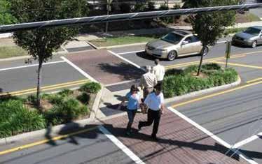


2 Widened sidewalks to accommodate greater pedestrian traffic and sidewalk cafes. Where land use is primarily commercial or mixed use, flex space should be hardscape. A planting zone with continuous street trees spaced no more than 10.0 metres apart to provide green amenity and shade. Bump out corners at intersections to minimize crossing distances. Reduction of driveways through the use of shared laneways and driveway entrances could help to enable opportunities for on-street parking. INTERSECTION CROSSWALKS Conceptual Section Option B property line Raised flex space that could accommodate parallel parking property line Looking West STREETSCAPE ELEMENTS M 2.0M 2.0M MARKET PEDESTRIAN PLANTING/ ZONE CLEARWAY PARKING 1 FLEX PARKING SPACE 2 PEDESTRIAN CLEARWAY 3 LANDSCAPE ZONE 4 STREET FURNITURE 5 CROSSWALK 6 VERTICAL ELEMENTS PEDESTRIAN CROSSWALKS 3 3.5M 2.75M 3.5M TRAVEL LANE TURN LANE TRAVEL LANE 2.25M 2.0M 3.0M PARKING PEDESTRIAN MARKET CLEARWAY ZONE 20m Right of Way MAIN STREET PUBLIC REALM DESIGN SECTION 03 Frameworks 25 MAIN STREET DESIGN GUIDELINES PUBLIC MEETING NOVEMBER 29,


 4.10 m PED. REALM 2.50 m SIDEWALK 4.")

 25m 0 50m 1:500 SHORT TERM VISION DEMONSTRATION SECTION")


 693-5893 Fax: (506) 693-3250 564")
3 KINGSLEY COURT STREET CONFIGURATION: BROOKSIDE DRIVE NORTHSIDE TRAIL TYPICAL MID-BLOCK CROSSWALK MAIN STREET B MATCH LINE TERRA NOVA CRES STREET ALIGNMENT PLAN TERRA NOVA CRES. JOHNSTON AVE JOHNSTON AVENUE MATCH LINE HYDROPOLE EXISTING CONDITION m RIGHT OF WAY 3.92 m PED. REALM m 0.60 m CURB (TYP.) 4.10 m PED. REALM 2.50 m SIDEWALK 4.00 m THRU LANE (WB) 2.30 m MEDIAN 4.00 m THRU LANE (EB) 2.40 m PARKING 2.50 m SIDEWALK UTILITY POLE B 3 TYPICAL CROSS-SECTION (STATION 0+641) 25m 0 50m 1:500 SHORT TERM VISION DEMONSTRATION SECTION MAIN STREET TRANSPORTATION PLAN FREDERICTON, NB. PROPOSED CONCEPT STN TO STN Crandall Engineering Ltd boul. St. George Blvd. Suite 400 Moncton, N.B. Canada E1E 4C9 Tel: (506) Fax: (506) CRANDALLENGINEERING.CA 133 Prince William Street Suite 703 Saint John, N.B. Canada E2L 2B5 Tel: (506) Fax: (506) Prospect Street Suite 101 Fredericton, NB Canada E3B 9M3 Tel: (506) Fax: (506) Pedestrian Clearway Parking & Landscape Roadway Landscape & Furniture Pedestrian Clearway DEMONSTRATION PLAN LONG TERM VISION MAIN STREET DESIGN GUIDELINES PUBLIC MEETING NOVEMBER 29,


 451-4400 Fax: (506) 857-2753 Pedestrian Parking & Clearway Landscape Roadway")
4 STREET CONFIGURATION: HYDRO POLE IN CENTER OF SIDEWALK FULTON AVENUE PUGH STREET ASYMMETRICAL LANDSCAPE/FURNITURE ZONE IL FULTON AVE C MATCH LINE COURT DRIVE STREET ALIGNMENT PLAN MATCH LINE MYRTLE CT. HILCOURT DRIVE 50m COORDINATE PLANTING WITH POLES TO MAINTAIN CLEARWAY TION PLAN. EPT DEMONSTRATION SECTION Crandall Engineering Ltd boul. St. George Blvd. Suite 400 Moncton, N.B. Canada E1E 4C9 Tel: (506) Fax: (506) CRANDALLENGINEERING.CA 133 Prince William Street Suite 703 Saint John, N.B. Canada E2L 2B5 Tel: (506) Fax: (506) Prospect Street Suite 101 Fredericton, NB Canada E3B 9M3 Tel: (506) Fax: (506) Pedestrian Parking & Clearway Landscape Roadway Pedestrian Clearway Landscape & Furniture DEMONSTRATION PLAN MAIN STREET DESIGN GUIDELINES PUBLIC MEETING NOVEMBER 29,


5 RAYMOND AVE STREET CONFIGURATION: HYDRO POLE AT EDGE OF CURB SYMMETRICAL LANDSCAPE/FURNITURE ZONE MAIN STREET STREET ALIGNMENT PLAN VE. EXISTING CONDITION SHORT TERM VISION DEMONSTRATION SECTION Pedestrian Parking & Clearway Landscape Roadway Pedestrian Clearway Landscape & Furniture DEMONSTRATION PLAN LONG TERM VISION MAIN STREET DESIGN GUIDELINES PUBLIC MEETING NOVEMBER 29,


6 DOUGLAS AVE STREET CONFIGURATION: HYDRO POLE IN CENTER OF SIDEWALK SYMMETRICAL LANDSCAPE/FURNITURE ZONE MAIN STREET F DOUGLAS AVE. STREET ALIGNMENT PLAN DEMONSTRATION SECTION Pedestrian Parking & Clearway Landscape DEMONSTRATION PLAN Roadway Landscape & Furniture Pedestrian Clearway MAIN STREET DESIGN GUIDELINES PUBLIC MEETING NOVEMBER 29,


7 VERTICAL ELEMENTS GATEWAYS EXISTING CONDITION SHORT TERM VISION FOR GATEWAY MAIN STREET DESIGN GUIDELINES PUBLIC MEETING NOVEMBER 29,


 Main front entrances must face Main Street, be emphasized in")


8 SITING GROUND LEVEL HEIGHT & MASS Mandatory build-to line at 0 to 3m from property line along Main Street and intersecting streets (corners) 40% built frontage for large sites (1ha+) 60% built frontage for small sites Active uses at the street edge Tall ground floor heights (4.5m) Main front entrances must face Main Street, be emphasized in design 75% transparency at ground level Street wall min. 2 storeys, max. 4 storeys May be 6 storeys at intersections Angular plane for surrounding streets and residential lots Taller buildings must provide public realm benefits North South INFILL MASSING 45 ANGULAR PLANE Angular Plane 45 degrees SIDE STREET SUBJECT PROPERTY MAIN STREET MINIMUM 2.0M STEP BACK ABOVE THE STREET WALL STREET WALL Street wall height should be 2-4 storeys. Taller portions of the building are stepped back. BUILT FORM DESIGN GUIDELINES MAIN STREET DESIGN GUIDELINES PUBLIC MEETING NOVEMBER 29,

 Corner")


9 GATEWAYS, CORNERS, VIEW TERMINUS Modest height exceptions for architectural elements (tower features, entrances) Corner buildings must address both street frontages with good design FACADE DESIGN Base-middle-top expression Fine grain rhythm of vertical articulation Emphasize entrances, provide sheltered entries, barrier free & accessible MATERIALS Quality and durability - wood, brick, stone, concrete, glass No vinyl, tinted glass/mirrors Don t mimic other materials Wood encouraged in material palette Vertical articulation of the facade Top Middle Base BUILT FORM DESIGN GUIDELINES MAIN STREET DESIGN GUIDELINES PUBLIC MEETING NOVEMBER 29,


10 SERVICING/PARKING ROOFS/MECHANICAL SIGNS Consolidate and coordinate driveways Promote a connected rear laneway system Parking and servicing at rear (away from view of Main Street) Parking in smaller pods, landscaped, screened Express the roof line Hide mechanical equipment from view, screen with same materials as building Encourage green roofs Integrate signs into architectural expression (sign bands, bays, datum lines) Prefer three dimensional lettering Discourage pylons, billboards, back-lit rectangular sign boxes Durable, high quality BUILT FORM DESIGN GUIDELINES MAIN STREET DESIGN GUIDELINES PUBLIC MEETING NOVEMBER 29,


11 MARKET ZONE DRIVE THRUS NORTHSIDE TRAIL is private property located between the building edge and the right of way (usually about 2-3m in width) Seamless continuation of public realm Encourage spill out and retail display Strongly preferred to be at rear of property, if required No drive aisles between buildings and public streets No entrance/exit to Main Street Locate drive aisle behind building, screen from view Buildings address trail with windows, entrances - no blank walls Encourage residential facing trail Provide walkway connections to main street Provide directional signs Main Street BUILT FORM DESIGN GUIDELINES MAIN STREET DESIGN GUIDELINES PUBLIC MEETING NOVEMBER 29,
13. New Construction. Context & Character
 13. New Construction Context & Character While historic districts convey a sense of time and place which is retained through the preservation of historic buildings and relationships, these areas continue
appendix and street interface guidelines
 appendix five: building and street interface guidelines appendix 5 building and street interface guidelines BOULEVARDS Boulevards are generally characterized by higher levels of traffic movement at higher
DRAFT Northeast Quadrant of Kipling Avenue and Highway 7 DRAFT AUGUST 29, Goals Land Use. The goals of this Plan are to:
 AUGUST 29, 2017 12.15 Northeast Quadrant of Kipling Avenue and Highway 7 12.15.1 Goals 12.15.2 Land Use The goals of this Plan are to: 12.15.2.1 General Provisions: a) Ensure the development of a compact
Clairtrell Area Context Plan
 Clairtrell Area Context Plan March 2005 Urban Development Services City Planning Contents 1. Introduction... 4 2. Development Structure... 6 2.1 Streets... 7 2.1.1 Sheppard Avenue and Bayview Avenue...
Appendix A COMMUNITY IMPROVEMENT PLAN DESIGN GUIDELINES
 Appendix A COMMUNITY IMPROVEMENT PLAN DESIGN GUIDELINES INTRODUCTION The continuous and desirable improvement of Arnprior requires a clear understanding of what is envisioned for the Town. These Design
Site Planning. 1.0 Site Context. 2.0 Pedestrian Circulation Systems. Pag e 2-23
 The following photographs from throughout the country illustrate key urban design principles. Photographs are provided to illustrate the overall urban design concepts described in Chapter 1 of the Downtown
WINDSOR GLEN DESIGN GUIDELINES
 WINDSOR GLEN DESIGN GUIDELINES Adopted by Council, 2006 WINDSOR GLEN REDEVELOPMENT DESIGN GUIDELINES August 2006 1.0 Master Plan Organization For this area of the Coquitlam Town Centre, a mix of high,
5.1 Site Plan Guidelines
 5. Community Core Guidelines Development of the Community Core will take place by plan of subdivision and site plan approval. It will occur in a phased manner that will reflect the timing of residential
Context Plan and Urban Design Guidelines for the lands west of Provost Drive
 Concord Park Place Context Plan and Urban Design Guidelines for the lands west of Provost Drive Amendment to the Bessarion-Leslie Context Plan October 2013 Concord Park Place Urban Design Guidelines The
SECTION TWO: Overall Design Guidelines
 SECTION TWO: Overall Design Guidelines This section provides overall design principles and guidelines for the Gardnerville Mixed-use Overlay. They provide criteria for mixed-use places consisting of residential,
(DC1) Direct Development Control Provision DC1 Area 4
 Direct Development Control Provision DC1 Area 4") . General Purpose (DC) Direct Development Control Provision DC Area 4 The purpose of this Provision is to provide for an area of commercial office employment and residential development in support of the
. General Purpose (DC) Direct Development Control Provision DC Area 4 The purpose of this Provision is to provide for an area of commercial office employment and residential development in support of the
East Bayshore Road Neighbourhood
 East Bayshore Road Neighbourhood Northridge Property Management Urban Design Brief 3195 East Bayshore Road City of Owen Sound January 2016 East Bayshore Road Neighbourhood Northridge Property Management
B. Blocks, Buildings and Street Networks
 B. Blocks, Buildings and Street Networks Figure IV.4 A rational block pattern with connected streets Introduction The single most important element in the physical and functional integration of mixed use
4.9 Mendocino Avenue Corridor Plan Design Guidelines
 4.9 Mendocino Avenue Corridor Plan Design Guidelines The Mendocino Avenue Corridor Plan addresses the area between College Avenue and Steele Lane. Mendocino Avenue is a busy arterial that runs parallel
4.0 Design Guidelines For The Village Centre. South fields Community Architectural Design Guidelines Town of Caledon
 4.0 Design Guidelines For The Village Centre 4.0 Design Guidelines for the Village Centre The Village Centre is the focal point of the entire South Fields Community and is designed as a traditional commercial
Urban Design Guidelines Townhouse and Apartment Built Form
 Urban Design Guidelines Townhouse and Apartment Built Form Town of Wasaga Beach Table of Contents 1. Introduction 1.1. Purpose 1.2. Urban Design Principles 1.3. Application of Guidelines 2. Site Design,
lot flankage Y street 16m 6m landscape strip for large site 3m landscape strip for small medium site
 Commercial General Commercial Objectives Create developments compatible with adjacent land uses in scale, function and character Define a consistent and attractive street edge with quality landscaping,
open house 3 CITY OF SALEM Downtown Streetscape Plan
 open house 3 Streetscape concepts CITY OF SALEM Downtown Streetscape Plan analysis concepts we are here refined concepts & document Feb 13th 1 2 3 apr 18th KICKOFF OPEN HOUSE Streetscape Work Group Walking
general corridor design guidelines gen-0.0
 general corridor design guidelines gen-0.0 facades gen-1.0 GEN-1.1: TRANSPARENCY GEN-1.1.1: WALL OPENINGS In order to create buildings that are visually interesting for passers-by, blank ground floor
Urban Design Brief December 23, 2015 Southside Construction Group Official Plan & Zoning By-Law Amendment
 Urban Design Brief Proposed Official Plan & Zoning By-Law Amendment 3244, 3263 and 3274 Wonderland Road South Southside Group December 23, 2015 TABLE OF CONTENTS Page No. INTRODUCTION... 1 SECTION 1 LAND
Yonge Eglinton Centre Urban Design Guidelines
 Yonge Eglinton Centre Urban Design Guidelines City Planning Urban Design January 2009 YONGE EGLINTON CENTRE INTRODUCTION.................................................... 1 GENERAL SITE PLAN OBJECTIVES......................................
8. Urban Villages. Other Relevant Policies & Bylaws Official Community Plan Development Permit Area Designations and Guidelines
 8. Urban Villages Urban villages provide walkable shops and services, encourage a neighbourhood social life, create a sense of place and provide different housing options. More housing near Urban Villages
Highland Village Green Design Guidelines
 Highland Village Green Design Guidelines Publishing Information Title Highland Village Green Design Guidelins Author The City of Calgary Status DRAFT - Proposed document subject to changes Additional Copies
Streets Vision
 streets 86 2.9 Vision : The Most Prevalent and Important Public Spaces Fixed routes of human travel have served as corridors for commerce and places for human interaction from the earliest trails and foot
Historic Yonge Street HCD Study Public Meeting #2
 Historic Yonge Street HCD Study Public Meeting #2 March 26, 2014 Archaeological Services Inc. Philip Goldsmith Architect Agenda: 7:00 p.m. Open House 7:30 p.m. Welcome and Presentation 8:00 p.m. Questions
401/Keele Provincial Campus Ontario Realty Corp.
 1.0 INTRODUCTION 1.1 Site Location and Description The study area consists of approximately 74 acres (30 ha) located in the Keele Street and Wilson Avenue area. It is bounded by Wilson Avenue to the north,
R STREET CORRIDOR NEIGHBORHOOD Site Plan and Design Review Supplemental Guidelines Checklist
 R STREET CORRIDOR NEIGHBORHOOD Site Plan and Design Review Supplemental Guidelines Checklist Applicant s Name: Project Address: Phone: Email: Applicant shall fill out the design guidelines checklist for
Urban Design Brief Milton Thompson Developments Limited
 Urban Design Brief Milton Thompson Developments Limited Mixed Use Node Louis St. Laurent Avenue at Thompson Rd. Milton, Ontario September 11, 2014 Prepared by MSAi Michael Spaziani Architect Inc. 1 INTRODUCTION
Commercial Development Permit Area
 City of Kamloops KAMPLAN Commercial Development Permit Area PURPOSE The purpose of this Development Permit Area (DPA) is to establish objectives and provide guidelines for the form and character of commercial
VILLAGE OF SKOKIE Design Guidelines for Mixed-Use Districts NX Neighborhood Mixed-Use TX Transit Mixed-Use CX Core Mixed-Use
 VILLAGE OF SKOKIE Design Guidelines for Mixed-Use Districts NX Neighborhood Mixed-Use TX Transit Mixed-Use CX Core Mixed-Use TABLE OF CONTENTS CHAPTER 1 SITE DESIGN Purpose 1 CHAPTER 2 SITE DESIGN Streetscape
WEST LOOP DESIGN GUIDELINES CHECKLIST
 WEST LOOP DESIGN GUIDELINES CHECKLIST Section 1.0 General Strategies 1.1 DESIGN EXCELLENCE: ENCOURAGE HIGH QUALITY AND INNOVATIVE DESIGN OF NEW BUILDINGS WITHIN THE WEST LOOP WITHOUT BEING PRESCRIPTIVE
Lambeth Main Street Streetscape Improvements
 Lambeth Main Street Streetscape Improvements Open House October 5th, 2017 Agenda 1. Introduction 2. Project Background 3. Context 4. Project Objectives 5. Design Principles & Approach 6. Streetscape Design
Figure 3-1: Public Realm Plan
 3 Public Realm Figure 3-1: Public Realm Plan 3.1 Public Realm Concept The public realm concept for the Little Mountain site integrates a clear and accessible movement network with public spaces for social
Regency Developments. Urban Design Brief. Holyrood DC2 Rezoning
 Regency Developments Urban Design Brief Holyrood DC2 Rezoning Stantec Consulting Ltd. 7-31-2017 1. Overview Regency Developments intends to rezone the lands located at 8510 and 8511 93 Avenue, within the
Cit of Kitchener Ur 6 an Design Manual PARTA. Desi n for _--::
 Cit of Kitchener Ur 6 an Design Manual Date PARTA Year ) Desi n for k Nodes Corridors _--:: Section Page 01 of 12 2 INTRODUCTION Purpose & Application Nodes and Corridors have been identified as key intensification
Cha p t e r 2: Ge n e r a l De s i g n Gu i d e l i n e s
 Downtown Ann Arbor Design Guidelines Cha p t e r 2: Ge n e r a l De s i g n Gu i d e l i n e s This chapter presents general design guidelines for new site plan or PUD projects in downtown Ann Arbor. The
Lower Merion Commercial Districts Issues and Characteristics Handbook November 2013
 Lower Merion Commercial Districts Issues and Characteristics Handbook November 2013 DRAFT TOWNSHIP-WIDE VISION: To maintain and enhance commercial areas to complement the surrounding high-quality residential
Buildings may be set back to create small plazas provided that these setbacks do not substantially disrupt the street wall s continuity.
 6-22 Community Design Street Walls and Street-front Setbacks The siting of buildings will play a critical role in establishing the character and sense of place for the District. Siting buildings at the
Arterial Mainstreets ottawa.ca
 Urban Design Guidelines for Development along Arterial Mainstreets ottawa.ca Ce document est disponible en français sur ottawa.ca. This document is available in French on ottawa.ca. Approved by City Council
PUBLIC RIGHT-OF-WAY IN THIS CHAPTER PUBLIC REALM
 PUBLIC RIGHT-OF-WAY This section provides design guidelines for improvements in the public right-of-way. The public right-of-way refers to streets, sidewalks, non-vehicular thoroughfares, parks and greenways
URBAN DESIGN BRIEF. 2136&2148 Trafalgar Road. Town of Oakville
 URBAN DESIGN BRIEF 2136&2148 Trafalgar Road Town of Oakville Prepared By: METROPOLITAN CONSULTING INC For 2500674 Ontario Inc November 2016 TABLE OF CONTENTS Page No. 1.0 Introduction/Description of Subject
Revitalization Guidelines for Corridors, Villages and Town Centres
 Revitalization Guidelines for Corridors, Villages and Town Centres July 2017 Updated May, 2018 Publishing Information Title: Prepared by: Revitalization Guidelines for Corridors, Villages and Town Centres
SECTION TWO: Urban Design Concepts
 SECTION TWO: Urban Design Concepts The Gardnerville Plan for Prosperity shapes economic opportunities presented by regional growth. The Urban Design Concepts provide policies and concepts for land use,
ELMVALE ACRES SHOPPING CENTRE MASTER PLAN
 ELMVALE ACRES SHOPPING CENTRE MASTER PLAN Contents 1.0 INTRODUCTION... 2 2.0 LOCATION... 2 3.0 EXISTING CONTEXT... 2 4.0 VISION & GUIDING PRINCIPLES... 2 5.0 LAND USE AND BUILT FORM... 4 5.1 St. Laurent
Urban Design Manual PLANNING AROUND RAPID TRANSIT STATIONS (PARTS) Introduction. Station Study Areas
 Introduction. Station Study Areas") 111111 PLANNING AROUND RAPID TRANSIT STATIONS (PARTS) Introduction The ION rapid transit system will link Waterloo, Kitchener and Cambridge through a central transit corridor (CTC). There are a number
111111 PLANNING AROUND RAPID TRANSIT STATIONS (PARTS) Introduction The ION rapid transit system will link Waterloo, Kitchener and Cambridge through a central transit corridor (CTC). There are a number
Urban Design Brief. 583, 585 and 589 OXFORD STREET EAST. Salt Clinic Canada Inc.
 Urban Design Brief 583, 585 and 589 OXFORD STREET EAST Salt Clinic Canada Inc. February 3, 2013 TABLE OF CONTENTS Page No. INTRODUCTION... 1 SECTION 1 LAND USE PLANNING CONCEPT... 1 1.1 The Subject Property...
BROADVIEW PLANNING STUDY Community Consultation Meeting 4. January 2016
 BROADVIEW PLANNING STUDY Community Consultation Meeting 4 January 2016 2 Agenda 6:00 pm Open House and Displays 7:00 pm Introductions, Agenda Review and Welcome 7:10 pm Presentation Broadview Planning
VEHICULAR AND PEDESTRIAN CIRCULATION
 This perspective sketch communicates the intended character and quality of a proposed streetscape design. Locate benches near a major intersection where people tend to gather. Seating and lighting provide
Corridor Transformation Strategy
 Corridor Transformation Strategy County Road 22 Special Planning Area Design Guidelines January 2012 D14-06017 Corridor Transformation Strategy County Road 22 Special Planning Area Corridor Design Guidelines
Wide asphalt driveway abutting school property. garage built with incompatible materials, too close to park. incompatible fencing materials
 Wide asphalt driveway abutting school property incompatible fencing materials garage built with incompatible materials, too close to park Lack of plantings as a buffer between private property and open
CHAPTER FIVE COMMUNITY DESIGN
 CHAPTER FIVE COMMUNITY DESIGN CHAPTER FIVE - COMMUNITY DESIGN Assumptions Frazier Park and Lebec have historically developed according to different patterns of spatial form. While both communities are
Urban Design Guidelines for Large-Format Retail
 Urban Design Guidelines for Large-Format Retail May 2006 Compte tenu de la nature de ce document, il n'est disponible qu'en anglais. La Ville pourra, sur demande, traduire ce document au complet ou en
Old East Village Dundas Street Corridor Secondary Plan
 Old East Village Dundas Street Corridor Secondary Plan DRAF T February 2019 Contents 1.0 INTRODUCTION 1 1.1 Background 1 1.2 Location 2 1.3 Purpose and Use 3 1.4 Vision and Principles 4 2.0 CHARACTER
Commercial Node Plan Devine Street/Jackson Blvd. COLUMBIA, SC
 Commercial Node Plan Devine Street/Jackson Blvd. COLUMBIA, SC 9.17.13 AGENDA 1 Introductions 2 Project Update 3 Concepts 4 Recommendations 5 Next Steps Introductions Project Update Process 5-Phase Process
Design Guidelines for the Route 30 Corridor Master Plan: Subdivision and Land Development Elements
 Design Guidelines for the Route 30 Corridor Master Plan: Subdivision and Land Development Elements East Whiteland Township- Chester County, PA Prepared by: Draft: May 7, 2018 Design Guidelines for the
Official Community Plan Bylaw No. 4360, 2004, Amendment Bylaw No. 4897, 2016 (Sewell s Landing)
") District of West Vancouver Official Community Plan Bylaw No. 4360, 2004, Amendment Bylaw No. 4897, 2016 (Sewell s Landing) Effective Date: 1089612v1 District of West Vancouver Official Community Plan Bylaw
District of West Vancouver Official Community Plan Bylaw No. 4360, 2004, Amendment Bylaw No. 4897, 2016 (Sewell s Landing) Effective Date: 1089612v1 District of West Vancouver Official Community Plan Bylaw
Lehigh Acres Land Development Regulations Community Planning Project
 Lehigh Acres Land Development Regulations Planning Effort Summary In July, 2010 Commissioner Frank Mann invited the Lehigh Acres community to start discussing how to achieve their recently adopted community
APPENDIX E DESIGN GUIDELINES
 APPENDIX E DESIGN GUIDELINES 1.1. PURPOSE OF THE DESIGN MANUAL The Design Manual is to be the primary reference document used to provide guidance on design of buildings within King s Wharf. 1.2. 1.3. APPROACH
built form design guidelines
 built form design guidelines Derry Green Corporate Business Park 17 built form design guidelines.1 Built Form Design Guidelines Section : Built Form Design Guidelines is intended to be used by both developers
Bank Street Secondary Plan
 1.1 Introduction The is a guide to the long term design and development of the portion of Bank Street between Riverside Drive and Ledbury Park, and provides direction on land use, built form, design, parking,
Community Design Plan
 Gardena General Plan 2006 Authority While the is not a required element of a General Plan, it is included because improving the community appearance and image is paramount to the overall quality of life
Tel: (705) Fax: (705)
 Fax: (705)") 521 and 525 Essa Road City of Barrie Tel: (705) 812-3281 Fax: (705) 812-3438 Email: INFO@IPSCONSULTINGINC.com 1 5 0 D U N L O P S T R E E T E A S T, S U I T E 2 0 1, B A R R I E O N T A R I O L 4 M 1 B
521 and 525 Essa Road City of Barrie Tel: (705) 812-3281 Fax: (705) 812-3438 Email: INFO@IPSCONSULTINGINC.com 1 5 0 D U N L O P S T R E E T E A S T, S U I T E 2 0 1, B A R R I E O N T A R I O L 4 M 1 B
URBAN DESIGN BRIEF URBAN DESIGN BRIEF 721 FRANKLIN BLVD, CAMBRIDGE August 2018
 URBAN DESIGN BRIEF URBAN DESIGN BRIEF 721 FRANKLIN BLVD, CAMBRIDGE August 2018 DESIGN BRIEF CONTENTS PART A 1.0 INTRODUCTION 2.0 DESCRIPTION & ANALYSIS OF SITE CONTEXT 3.0 DESIGN CONSTRAINTS AND OPPORTUNITIES
New-Cast Mixed-use Development Proposal King Street West, Newcastle, Ontario
 URBAN DESIGN BRIEF New-Cast Mixed-use Development Proposal King Street West, Newcastle, Ontario TABLE OF CONTENTS: 1.0 Executive Summary 2.0 Creating Vibrant and Sustainable Urban Places: Excerpts from
Design Guidelines and Development Standards for Southwood Ranch. Prepared February, 2016 by
 Design Guidelines and Development Standards for Southwood Ranch D e s i g n D i s t r i c t Prepared February, 2016 by Table of Contents Introduction 2 District Overlay Map. 3 Development Standards. 4
Mixed Use Centres Development Permit Guidelines
 1 Mixed Use Centres Development Permit Guidelines Area Commercial or Mixed Use development occurring in City Centre, Urban Centre, Neighbourhood Centre, or Institutional Complex land use designations is
WATERFRONT DISTRICT DESIGN STANDARDS
 WATERFRONT DISTRICT DESIGN STANDARDS 20.25.080 WATERFRONT DISTRICT A. Purpose. This section is intended to implement The Waterfront District Subarea Plan by: 1. Creating a safe, vibrant mixed-use urban
HIGHLAND VILLAGE GREEN URBAN DESIGN PRINCIPLES/GUIDELINES
 URBAN DESIGN GUIDING PRINCIPLES/GUIDELINES CONTEXT/CHARACTER The City of Calgary s Municipal Development Plan (MDP), Transit-Oriented Development (TOD) Policy Guidelines and Main Street/Corridor policy
A. Background Summary of Existing Challenges and Potential Possibilities. 1. Summary of Existing Assets and Potential Opportunities
 A. Background 1 A Main Street Master Plan Study was performed and completed in October of 2007. The study was initiated to review current land uses and development patterns along Main Street, from Parrish
GUIDING PRINCIPLES IN THIS CHAPTER
 GUIDING PRINCIPLES The guiding principles and design concepts in this chapter work together with the Chapel Hill 2020 Comprehensive Plan to support new public places that can be enjoyed by all while also
SECTION V: DESIGN GUIDELINE EXAMPLES
 SECTION V: DESIGN GUIDELINE EXAMPLES Introduction The Syracuse Town Center is envisioned as an area that creates a sense of place, a community downtown. As such, the Town Center Committee recommended the
Urban Design Brief to 1557 Gordon Street & 34 Lowes Road West
 Urban Design Brief 1533 to 1557 Gordon Street & 34 Lowes Road West Reid s Heritage Homes Ltd. & 883928 Ontario Ltd. and RHH Property Management Ltd. City of Guelph Zoning By-law Amendment November 2017
1354 CARLING AVENUE FORMAL RESUBMISSION HOLLOWAY LODGING
 1354 CARLING AVENUE FORMAL RESUBMISSION HOLLOWAY LODGING DECEMBER, 2017 THE SITE 1354 CARLING AVENUE The subject property is at a key gateway to the Carlington Neighbourhood, and when combined with future
Chapter 14 Streetscape Improvements
 This chapter presents streetscape design concepts for key streets and gateways in the Downtown Specific Plan area. This chapter is organized as follows: 14 Streetscape Improvements 14.1 Streetscape Treatments
Hamilton Road Corridor Streetscape Master Plan. Open House October 4 th, 2017
 Hamilton Road Corridor Streetscape Master Plan Open House October 4 th, 2017 Agenda 1. Introductions Agenda Overview 2. Project Background 3. Existing Conditions 4. Strengths, Weaknesses, Opportunities
GUIDELINES REPLACEMENT HOUSING GUIDELINES LOCATION INTRODUCTION URBAN DESIGN GUIDELINES
 Replacement housing in the former City of North York will be consistent with the following urban design guidelines. They provide a framework for residential re-development in the former City of North York
King-Spadina Secondary Plan Community Consultation Meeting. Michelle Knieriem, City Planner October 11, 2017
 King-Spadina Secondary Plan Community Consultation Meeting Michelle Knieriem, City Planner October 11, 2017 Agenda 6:30 Welcome 6:35 Presentation 7:15 Question and Answer Session 8:15 Closing Remarks HOW
URBAN DESIGN BRIEF Gordon Street City of Guelph. Prepared on behalf of Ontario Inc. March 25, Project No. 1507
 URBAN DESIGN BRIEF 1131 Gordon Street City of Guelph Prepared on behalf of 1876698 Ontario Inc. March 25, 2016 Project No. 1507 423 Woolwich Street, Suite 201, Guelph, Ontario, N1H 3X3 Phone (519) 836-7526
PROPOSED WATERFRONT DISTRICT DESIGN STANDARDS
 PROPOSED WATERFRONT DISTRICT DESIGN STANDARDS 20.25 DESIGN REVIEW. 20.25.080 WATERFRONT DISTRICT A. Purpose. This section is intended to implement The Waterfront District Subarea Plan by: 1. Creating a
2.5 Roads. Loading and service areas adjacent to Highway 401 should be screened through architectural walls and/or landscape buffer planting.
 N HIGHWAY OFF RAMP 2.5 Roads A legible road network with a clear hierarchy will help create a connected community, both within and surrounding the Milton Heights. The following section outlines the proposed
DRAFT. 10% Common Open Space
 % OF CHARLOTTE IS CATEGORIZED AS A. LAND USES : Placeholder map displaying location of Place Type GOALS: Accommodate XX% of future growth. Provide a concentration of primarily commercial and civic activity
1. Avoid extensive blank walls that would detract from the experience and appearance of an active streetscape.
 08 ARCHITECTURAL DETAIL Once a building s massing and street wall have been defined, architectural details, including façade variation, materials and window treatment, shape a building s visual identity.
Route 347. New York State Department of Transportation Region 10, Long Island. THE GREENING of ROUTE 347
 The GREENING of Route 347 The Greening of Route 347 The Greening of Route 347: History 3 The Greening of Route 347 4 The Greening of Route 347 5 The Greening of Route 347 Smith Haven Mall 6 The Greening
B L A C K D I A M O N D D E S I G N G U I D E L I N E S for Multi-family Development
 B L A C K D I A M O N D D E S I G N G U I D E L I N E S for Multi-family Development Adopted June 18, 2009 This section of the Design and focuses on site planning and design guidance for new multi-family
Mark-up of the effect of the proposed Bronte Village Growth Area OPA No.18 on the text of section 24, Bronte Village, of the Livable Oakville Plan
 Mark-up of the effect of the proposed Bronte Village Growth Area OPA No.18 on the text of section 24, Bronte Village, of the Livable Oakville Plan Notes: This document is provided for information purposes
EXISTING TOWNHOUSE. What s working & What s not?
 What s working & What s not? Distance from the sidewalk/street to the building Landscape vs. Hardscape in front of the building Porches, stoops, steps, and entries Residential vs. contemporary character
Mid-Rise Buildings on Toronto s Avenues Responding to the Public Realm Andrea Oppedisano, City of Toronto
 Mid-Rise Buildings on Toronto s Avenues Responding to the Public Realm Andrea, City of Toronto Introduction The Avenues and Mid-Rise Buildings Study explores opportunities to encourage a built form that
QUEEN-RIVER SECONDARY PLAN
 34 QUEEN-RIVER SECONDARY PLAN 34. QUEEN RIVER SECONDARY PLAN 1. INTRODUCTION The Queen-River area is approximately 6.4 hectares and is located at the eastern edge of the Downtown as shown on Map 34-1.
DRAFT. 1. General Purpose. 2. Area of Application. 3. Uses CLIFTON PLACE AREA A DC2 (DRAFT)
") CLIFTON PLACE AREA A DC2 () May 1, 2017 1. General Purpose To accommodate a high rise, high density residential Tower and podium that will accommodate a potential mix of commercial and residential uses,
CLIFTON PLACE AREA A DC2 () May 1, 2017 1. General Purpose To accommodate a high rise, high density residential Tower and podium that will accommodate a potential mix of commercial and residential uses,
THE PRESERVE PHASE THREE URBAN DESIGN BRIEF. Second Submission: March 7, 2016
 THE PRESERVE PHASE THREE URBAN DESIGN BRIEF i Second Submission: March 7, 2016 Based on: North Oakville Urban Design and Open Space Guidelines Prepared by: NAK Design Strategies THE PRESERVE PHASE 3 TABLE
chapter DESIGN GUIDELINES NEW RIVER MASTER PLAN REPORT
 chapter DESIGN GUIDELINES NEW RIVER MASTER PLAN REPORT .76 DESIGN GUIDELINES An Overview design guidelines NEW RIVER MASTER PLAN Design Guidelines can transform the image of a city. Specific, design-based
URBAN DESIGN BRIEF REPORT
 URBAN DESIGN BRIEF REPORT PREPARED FOR 2568401 ONTARIO INC NEW GASBAR, CONVENIENCE STORE & CARWASH DEVELOPMENT @ 1509 FANSHAWE PARK ROAD WEST LONDON, ONTARIO GAMA ENGINEERING INC. PROJECT NUMBER 1669 PREPARED
THE CONSULTING TEAM. WSP Canada Group Limited. John Tassiopoulos Greg Bender Valentina Chu
 THE CONSULTING TEAM WSP Canada Group Limited John Tassiopoulos Greg Bender Valentina Chu TABLE OF CONTENTS 1.0 INTRODUCTION 1 1.1. Purpose of the Standards 1 1.2 Objectives of the Standards 1 1.3 Expectations
Urban Design Brief Proposed Residential Development 5219 Upper Middle Road City of Burlington
 Urban Design Brief Proposed Residential Development 5219 Upper Middle Road City of Burlington Prepared by Weston Consulting Prepared for BLOOMFIELD DEVELOPMENT INC. Date: March 2017 Table of Contents 1.
The Humber Bay Shores. Urban Design Guidelines Update and Public Realm Plan. January, 2008
 The Humber Bay Shores Urban Design Guidelines Update and Public Realm Plan January, 2008 prepared by Brook McIlroy Planning and Urban Design / Pace Architects Content i EXECUTIVE SUMMARY KEY RECOMMENDATIONS
PIKE PINE RENAISSANCE: ACT ONE. October 19, 2017
 PIKE PINE RENAISSANCE: ACT ONE October 19, 2017 WATERFRONT SEATTLE PROGRAM PROJECT INTRODUCTION Pike and Pine streets, between First and Melrose avenues Pedestrian and streetscape improvements Budget:
COMMERCIAL & INDUSTRIAL DESIGN GUIDELINES CITY OF RANCHO CUCAMONGA PLANNING DIVISION
 COMMERCIAL & INDUSTRIAL DESIGN GUIDELINES CITY OF RANCHO CUCAMONGA PLANNING DIVISION INTRODUCTION These guidelines were prepared in response to the needs of many users: developers, property owners, architects,
New Street Proposed Redevelopment Architecture & Urban Design Brief
 2130 2136 New Street Proposed Redevelopment Architecture & Urban Design Brief Prepared By: Cynthia Zahoruk Architect Inc. 3077 New Street, Burlington, ON, L7N 1M6 TABLE OF CONTENTS Background and Objective
CONTENTS 8.0 LAND USE 8.1 GENERAL LAND USE 8.2 RESIDENTIAL 8.3 MIXED USE 8.4 COMMERCIAL 8.5 EMPLOYMENT LANDS
 8-2 Land Use 8.0 LAND USE CONTENTS 8.1 GENERAL LAND USE 8.1.1 Uses provided for in all Land Use Designations 8.1.2 Uses prohibited in Hazardous Lands, Hazardous Sites and Special Policy Areas 8.1.3 Uses
THE CORPORATION OF THE CITY OF VAUGHAN MAJOR MACKENZIE STREETSCAPE STUDY
 THE CORPORATION OF THE CITY OF VAUGHAN MAJOR MACKENZIE STREETSCAPE STUDY STANTEC CONSULTING LTD. 300-675 Cochrane Drive, West Tower Markham, ON L3R 0B8 Tel: (905) 944-7777 Fax: (905) 474-9889 April 2010