Lower Columbia River and Coastal Landscape Conservation Design
|
|
|
- Evangeline Rogers
- 5 years ago
- Views:
Transcription


1 Today s Presenters: Lower Columbia River and Coastal Landscape Conservation Design John Mankowski, North Pacific Landscape Conservation Cooperative Sara Evans-Peters, Pacific Birds Tom Miewald, US Fish and Wildlife Service and NPLCC Khem So, US Fish and Wildlife Service Meghan Kearney, North Pacific Landscape Conservation Cooperative Facilitator: Lisa DeBruyckere, Creative Resource Strategies, LLC
 Budget and Letters of Support (L. DeBruyckere) Questions and Answers (M. Kearney, L. DeBruyckere) Next Steps (J.")
2 Agenda Welcome (L. DeBruyckere) Background J. Mankowski S. Evans-Peters The Project Plan (T. Miewald, K. So) Budget and Letters of Support (L. DeBruyckere) Questions and Answers (M. Kearney, L. DeBruyckere) Next Steps (J. Mankowski) Website and communications (M. Kearney) The End

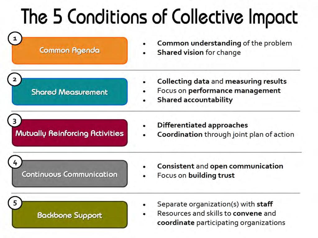
3 Why? Many natural, cultural, and social values are supported by this unique landscape Numerous groups are involved in managing these resources within the context of their authorities, missions, and needs. And... there is rapidly growing need to understand how the environment will be change and how we can adapt But... there is no forum/process to convene these interests, asses large-scale impacts to valued resources, and align conservation efforts to achieve collective impacts towards common goals Therefore, the NPLCC has been asked support this ambitious project to develop a climate resilient conservation blueprint for the region.
4 Goals of the Pacific Northwest Coast Landscape Conservation Design Foster collaboration, communication, learning and collective impact develop a community of practice for adaptation in the region Understand how landscape scale stressors will affect this region and resources of interest Craft a conservation blueprint(s) to target conservation and adaptation strategies and actions. Develop products (maps, tools, models, education materials) to support implementation of the blueprint framework, Track our progress and improve over time.

5 Initial Team Facilitate conceptual approach Stakeholder collaboration Information sharing Guidance and direction Lead development of project plan Core Team (Co-managers/Sovereign entities) Lead/manage project Pacific Northwest Coast Conservation Blueprint Technical Advisors Scientists to provide technical information and data to inform project goals Stakeholders Represent the interests and values of entities within the geographic scope of the project

6 Initial Team Members North Pacific Landscape Conservation Cooperative US Fish and Wildlife Service Pacific Birds Habitat Joint Ventures Current Core Team Members Columbia River Estuary Study Taskforce Columbia River Intertribal Fish Commission David Evans and Associates Ducks Unlimited Lower Columbia Fish Recovery Board National Park Service Lewis and Clark National Historical Park Natural Resource Consulting Convening/Facilitation Lisa DeBruyckere -- Creative Resource Strategies, LLC North Pacific Landscape Conservation Cooperative Oregon Department of Transportation Oregon Parks and Recreation Department PC Trask and Associates Pacific Birds Habitat Joint Venture Pacific Marine and Estuarine Fish Habitat Partnership Sauvie Island Habitat Partnership The Nature Conservancy Tillamook Estuaries Partnership USFWS US Geological Survey Northwest Climate Science Center Washington Coast Sustainable Salmon Partnership Washington Department of Fish and Wildlife Washington State Recreation and Conservation Office Western Invasives Network Yakama Nation

7 Growing interest NGOs Audubon Washington Federal agencies Bonneville Power Administration NOAA Fisheries NRCS PNNL, Marine Sciences Lab US Army Corps of Engineers US Environmental Protection Agency US Forest Service Tribes Confederated Tribes of the Colville Reservation Cowlitz Tribe Coquille Tribe Quinault Indian Nation State governments Northwest Power and Conservation Council Oregon Department of Fish and Wildlife Oregon Department of Land and Conservation Development Oregon Watershed Enhancement Board South Slough National Estuarine Research Reserve Washington Connectivity Partnership Washington Department of Ecology Other Partners Columbia River Estuary Study Taskforce University of Washington Washington Sea Grant Industry Columbia Land Trust Ecotrust Estuary Technical Group Institute for Applied Ecology NatureServe Pinchot Institute for Conservation Wetlands Conservancy Wild Salmon Center Aardscan Biological and Environmental Adaptation/Insight AECOM Another Set of Eyes Ballard Ecological Consulting EcoWest Environmental Science Associates Metro
 - COMPLETED Phase II- UNDERWAY Information gathering and sharing.")
8 Project Plan Phase I Convene parties, clarify interests/intent/refine conceptual approach, develop detailed project plan. Produce problem statement and establish conservation goals and objectives (April 2016) - COMPLETED Phase II- UNDERWAY Information gathering and sharing. Conduct assessments; develop adaptation strategies, and implementation options (December 2017) Implement the design Phase III - Monitor, review, and revise the LCD (2018) Monitor, Evaluate, Adjust
9 The Problem Statement Need - Achieve conservation goals for key focal species and habitats Issue - No unified landscape-scale conservation blueprints for the region that identify valued resources and consider the impacts of large-scale stressors on those resources Opportunities: Identify valued resources (biological, cultural, societal) Assess the impacts of stressors (i.e., climate change, development) Create a conservation blueprint to guide management actions to achieve common conservation outcomes.

10 Conservation Priority: Sustaining Coastal Wetlands Sustain coastal wetland habitat in the Pacific Northwest in the face of large scale landscape changes, i.e. sea level rise Promote planning, restoration techniques, and public policies, that are responsive to threats and adaptable to the uncertainty associated with a changing climate The LCD process is important to Pacific Birds None of us can do this alone build networks to rally around common goals Each organization can bring forward their strengths and organizational niches - for us, its through a bird lens Avoid duplication of and support shared conservation efforts End goal to have spatial information that helps us all invest resources effectively and efficiently to achieve shared conservation priorities
11 Help inform LCD priorities (targets) Reviewing existing plans, documents, and reports from organizations working within the geographic scope of this LCD Identifying, synthesizing, and summarizing goals and targets Compile threats Identify and summarize major threats and stressors that limit our ability to achieve our goals Build on the great work that s already available OVERLAPPING PRIORITIES

12 Creating the Roadmap 3 Core Team meetings 2 Technical Team meetings 2 Polls Review of literature Other LCD efforts
 Adequate for understanding terrestrial and aquatic connectivity Whole watersheds Convergence with existing planning boundaries The area")
13 Criteria for Identifying the Geographic Scope Consistent/coherent ecoregion Similarities within estuarine, terrestrial, and riverine ecoregions. Shares common change agents (threats & stressors) Adequate for understanding terrestrial and aquatic connectivity Whole watersheds Convergence with existing planning boundaries The area includes the terrestrialmarine interface
14 Very important Important Somewhat important Important for version 2.0 Number of responses Prioritization of strategies Priority core areas for species and/or habitats Effects of climate change on priority habitats and species Assessment of past and present condition Connectivity zones for wildlife Planning across ecosystem types Impacts to habitats Ecosystem services and species from in combination with population increase species/habitat and development conservation Connect existing small projects & protected areas
15 25 Core decision support products 20 Number of responses

16 Schmitz et al Conserving Biodiversity: Practical Guidance about Climate Change Adaptation Approaches in Support of Land-use Planning

17 The 4 Elements of Landscape Conservation Design Convening Stakeholders Assessing Current and Plausible Future Conditions Spatial Design Strategy Design

18 General Approach Prototyping, build version 1.0 Build from and augment existing landscape-scale efforts and tools. Balance the science with convening
19 Element 1: Convening Goal: Convene and maintain a broad base of partners throughout the project. Objective 1.1: Build and maintain core team and technical teams and communicate with stakeholders regarding the LCD processes, outcomes, and next steps. Tasks: Fund and hire a coordinator/facilitator to help manage the overall LCD process. Hold regular bi-monthly Core Team meetings to track progress, steer the process, and communicate emerging needs and interests. Develop a social network map that that assesses the relationships between key natural resource interests in the region. Convene a State of the Pacific Northwest Coast symposium, a 1 2 day event, midway through the project, that convenes stakeholders around the ecoregion. Develop a communications plan and materials for partner engagement and to ensure relevance.

20 Element 1: Convening Objective 1.2: Identify shared goals and objectives for a suite of conservation and associated human well-being targets. Continual throughout the process
21 Identifying Targets Coarse Filter Conservation (potentials) Conifer Forests Estuaries Wetlands Salmon Connectivity Freshwater systems and riparian zones. Fine filter, or nested Human Well-being Ecosystem services Working lands Aesthetic values Recreation Health
22 Element 2: Assess Current and Plausible Future Conditions Goal: Assess the current and future condition of shared conservation and human well-being targets. Objective 2.1: Identify and map the extent and condition of conservation targets throughout the region to build baseline conditions. Objective 2.2: Identify and map human well-being targets (HWB) throughout the region. Objective 2.3: Identify and map future threats across the landscape, with an emphasis on climate change.

23 Objective 2.1: Identify and map the extent and condition of conservation targets throughout the region to build baseline conditions. Conservation Target Conifer Forests Attribute Category LANDSCAPE CONTEXT LANDSCAPE CONTEXT CONDITION CONDITION CONDITION SIZE SIZE LANDSCAPE CONTEXT Key Attribute Landscape pattern and structure Connectivity Distribution of ecological system physiognomic types Vegetation Composition and Structure Vegetation Composition and Structure Absolute Size Relative Size Fire Regime Indicator Acreage of land surrounding patches that is in seminatural condition Acreage of land in patches connected to other patches Acreage in forested ecological systems Cover across majority of the acreage Composition of native plant species, and invasive annual species, across the majority of the acreage Patch size across the majority of the acreage Current extent/original natural extent Departure from historical fire regime Current Status FAIR FAIR POOR to GOOD FAIR FAIR FAIR POOR (TBD)

24 Objective 2.2: Identify and map human well-being targets (HWB) throughout the region. Tasks: Convene a sub-team of experts in human dimensions of landscape conservation to identify high-value needs and a long-term approach for addressing HWB targets. Assess the utility of existing data for addressing HWB targets. Develop a work plan and proposal for a robust implementation of HWB targets in version 2.0.


25 Objective 2.3: Identify and map future threats across the landscape, with an emphasis on climate change. Examples: Example: GLEAM Example: Arid Lands Initiative
26 Element 3: Development of a Spatial Design Goal: Develop a conservation blueprint that represents an efficient, resilient, and representative network of priority places and connectivity zones to meet shared goals. Objective 3.1: Identify priority core areas. Objective 3.2: Map connectivity zones. Objective 3.3: Assess the resiliency of the design to climate change and other stressors. Objective 3.4: Scenario planning workshop. Objective 3.5: Develop a web-based interface.


27 Objective 3.1. Identify priority core areas. Synthesize existing priority areas Identify priority areas for terrestrial targets Identify priority areas for freshwater targets Identify priority areas for estuarine targets Identify priority areas that meet goals across systems Example: Arid Lands Initiative Example: Connecticut River Watershed

28 Objective 3.2. Map connectivity zones. Tasks: Convene a one-day workshop to share knowledge about past and existing connectivity work in the region, identify a limited suite of focal species throughout the region, and develop a methodology. Model connectivity using GIS methods and incorporate climate gradient analysis Work with regional partners to explore connectivity mapping for nearshore marine habitats and species as well as aquatic-associated species. Example: WWHCWG


29 Objective 3.3. Assess the resiliency of the design to climate change and other stressors Examples: Arid Lands Initiative


30 Objective 3.4. Scenario planning workshop. Objective 3.5. Develop a web-based interface. Example: Central Valley Landscape Conservation Project Example: South Atlantic Conservation Blueprint 2.0
31 Element 4: Strategy Development Goal: Create opportunities for partners to identify coordinated strategies to achieve the shared goals and objectives articulated within Element 1, in the locations mapped by the spatial design in Element 3, to adapt to the stressors and threats described in Element 2. Objective 4.1: Identify a portfolio of mutually reinforcing strategies. Objective 4.2: Identify strategic investments to achieve conservation goals. Objective 4.3: Measuring actions against chosen strategies. Objective 4.4: Ensure that this is a living document.
32

33
34


35 Budget and Letters of Support

36 Next Steps Share recording of this webinar with interested stakeholders. Prioritize LCD Project Plan tasks, priorities, timeframes, and associated budgets. Convene a Funding Committee to develop a funding strategy to fund LCD priorities. Funding Committee proposes funding strategy to Core Team. Convene an ALL HANDS meeting of in the Fall of 2016 to: Share the progress made to date; Share the progress Pacific Birds has made compiling conservation priorities within the region; Form work groups to being implementing elements of the framework; and Create opportunities for partners to share updates and progress on conservation initiatives within the geographic scope of the LCD. Related efforts/topics: sea level rise conference (informational agenda item) Communication tools


37 Questions

38 Pacific Northwest Coast Blueprint Website


39 Want to track progress on this initiative? Provide us with your contact information: Want to serve on the Funding Committee? Contact Lisa DeBruyckere at
Peninsular Florida Landscape Conservation Cooperative. Marine and Estuarine Priority Resources and Conservation Targets
 Peninsular Florida Landscape Conservation Cooperative Marine and Estuarine Priority Resources and Conservation Targets Why are we here today? Workshop Goals: Develop a list of potential conservation targets
ROLE OF LANDSCAPE CONSERVATION COOPERATIVES IN EVERGLADES RESTORATION
 ROLE OF LANDSCAPE CONSERVATION COOPERATIVES IN EVERGLADES RESTORATION GEER April 2017 Steve Traxler 1, Todd Hopkins 1, Beth Stys 2 1 US Fish and Wildlife Service 2 Florida Fish & Wildlife Conservation
California Landscape Conservation Cooperative
 californialcc.org California Landscape Conservation Cooperative Debra Schlafmann, Coordinator October 19, 2016 Landscape Conservation Cooperatives There are 22 LCCs http://lccnetwork.org/ LCC Map Landscape
1.16 million KM 2 5 States, 2 Provinces Integrated Partnerships with neighboring LCCs, NW and NC Climate Science Centers, PNW
 GNLCC Goal: Coordinate, facilitate, promote and add value to large landscape conservation to build resource resilience in the face of climate change and other landscape level stressors through: Support
Collaborative Conservation across Landscapes: Experiences from the Upper Midwest and Great Lakes LCC 2/29/2016. GreatLakesLCC.org
 Collaborative Conservation across Landscapes: Experiences from the Upper Midwest and Great Lakes LCC 2/29/2016 GreatLakesLCC.org Personal introduction Brad Potter - Science Coordinator for the Upper Midwest
Ecosystem Restoration Business Line Budgeting A Systems Approach
 Ecosystem Restoration Business Line Budgeting A Systems Approach Laura Orr (NWS), Shawn Phillips (MVM), Greg Steele (NAO) Introduction Chesapeake Bay Bridge Mouth of Mississippi River Bonneville Dam Fish
STEWARDSHIP OF LONG ISLAND SOUND S ECOLOGICAL AND RECREATIONAL RESOURCES
 STEWARDSHIP OF LONG ISLAND SOUND S ECOLOGICAL AND RECREATIONAL RESOURCES Robin Kriesberg, Save the Sound, Inc. Thomas Halavik, US Fish and Wildlife Service Coastal Program An Initiative to Identify, Protect
2014 South Atlantic LCC
 2014 South Atlantic LCC Annual Report 1 Allie Stewart, U.S. FWS The South Atlantic LCC s 2014 Annual Report this year of progress and accomplishments is dedicated to South Atlantic LCC Coordinator, Ken
INTEGRATING PROTECTED AREAS INTO THE WIDER LANDSCAPE, SEASCAPE AND RELATED SECTORS. An Overview
 INTEGRATING PROTECTED AREAS INTO THE WIDER LANDSCAPE, SEASCAPE AND RELATED SECTORS An Overview USING AN EXAMPLE FROM NORTHEAST US Relationship of IPAWLS guide to other planning and assessment processes
Aquatic, Terrestrial and Landscape Conservation Design Tools and Products of the North Atlantic LCC
 Aquatic, Terrestrial and Landscape Conservation Design Tools and Products of the North Atlantic LCC Scott Schwenk Science Coordinator, North Atlantic LCC Chesapeake Bay FWS Partners Meeting Annapolis,
Stone Soup Conservation Responding to Landscape Challenges in the Eastern Tallgrass Prairie & Big Rivers Landscape Conservation Cooperative (LCC)
") Stone Soup Conservation Responding to Landscape Challenges in the Eastern Tallgrass Prairie & Big Rivers Landscape Conservation Cooperative (LCC) Glen Salmon & Dr. Gwen White Eastern Tallgrass Prairie
Stone Soup Conservation Responding to Landscape Challenges in the Eastern Tallgrass Prairie & Big Rivers Landscape Conservation Cooperative (LCC) Glen Salmon & Dr. Gwen White Eastern Tallgrass Prairie
Middle Mississippi River. Regional Corridor
 Middle Mississippi River St. Louis District Regional Corridor Lessons Learned from a Collaborative Planning Study Brian Johnson US Army Corps of Engineers 12 th Biennial Governor s Conference on the Management
Landscape Conservation Design:
 The Castello Plan (1660) Jacques Cortelyou (ca 1625-1693) Google Maps (2014) Landscape Conservation Design: An adaptation pathway for social transformability in sustainability planning Rob Campellone USFWS,
Category for Proposal: Partner Forums
 Project Title: Strategic conservation planning for management applications in Cascadia. Project Coordinator: Jen Watkins (Conservation Northwest, jwatkins@conservationnw.org) Project PIs: Cascadia Partner
Blue/Green Infrastructure Study Accomack County, VA
 Blue/Green Infrastructure Study Accomack County, VA Draft Asset Maps March 8-9, 2010 Green Infrastructure Center, Inc. 2 Overview What is Green and Blue Infrastructure Project Timeline & Tasks Literature
INTERMOUNTAIN WEST JOINT VENTURE Strengthening Alliances for Conservation
 INTERMOUNTAIN WEST JOINT VENTURE Strengthening Alliances for Conservation THE PEOPLE OF THE IWJV The people of the Intermountain West are our greatest asset. We, at the IWJV, believe in forging productive,
systems is available on the Colorado Wetland Information Center (CWIC) website.
 website.") Colorado Natural Heritage Program Wetland Program Plan -- Dec 2015 Status Update and Addendum -- The Colorado Natural Heritage Program (CNHP) developed a Wetland Program Plan (WPP) in 2010 for the planning
Colorado Natural Heritage Program Wetland Program Plan -- Dec 2015 Status Update and Addendum -- The Colorado Natural Heritage Program (CNHP) developed a Wetland Program Plan (WPP) in 2010 for the planning
A Landscape Scale Approach to Habitat Conservation
 A Landscape Scale Approach to Habitat Conservation Sara Vickerman December 2012 Why this session? Disconnect between landscape level assessments and planning, and transactions on-the-ground focused on
Connecticut River Watershed Initiative
 Connecticut River Watershed Initiative How it came about UMASS Amherst What is the concept? What is the near-term process? How it came about 1992-2002 University of Oregon CLAMS 1998 UMass proposal to
Developing Landscape Conservation Designs & Adaptation Strategies for the GCPO LCC
 Developing Landscape Conservation Designs & Adaptation Strategies for the GCPO LCC D. Todd Jones-Farrand Science Coordinator david_jones-farrand@fws.gov 29-30 June 2015 Replace this box with key image
Northeast Conservation
 Northeast Conservation Framework What is it and why do we need it? National LCC Workshop Denver CO March 2012 Northeast Conservation Framework History Context Future NA Landscape Conservation Cooperative
Northeast Florida Estuary Restoration Initiative: A District Perspective. Ron Brockmeyer, SJRWMD And a cast of thousands!!
 Northeast Florida Estuary Restoration Initiative: A District Perspective Ron Brockmeyer, SJRWMD And a cast of thousands!! Success and Local Partners Impoundment Reconnection / Restoration (Merritt Island
Planning for Staten. Habitat Restoration and Green Infrastructure. Island s North Shore
 Habitat Restoration and Green Infrastructure Planning for Staten Island s North Shore Community Board 1 March 1, 2018 NYC Parks Forestry, Horticulture, and Natural Resources Funded by the NYS Department
Landscape Conservation Design April, 2014
 Designing Sustainable Landscapes in the Northeast A project of the North Atlantic Landscape Conservation Cooperative & Northeast Climate Science Center Landscape Conservation Design April, 2014 Conceptual
Workshop on Area-based Management and Regional Cooperation for the Implementation of Ocean-related Sustainable Development Goals
 Workshop on Area-based Management and Regional Cooperation for the Implementation of Ocean-related Sustainable Development Goals UN Environment and European Commission 9-10 February 2017, Brussels Healthy
Green Infrastructure Project Guidance
 OTHER OPTIONS Green Infrastructure Project Guidance Stakeholder Informed Introduction Green infrastructure is an approach to mitigating environmental challenges using vegetation, soils and natural processes
Landscape Conservation Design:
 SPRING 2016 The Spring 2016 Newsletter highlights how the Appalachian LCC and its partners are addressing landscape issues and bringing together a community to find sustainable solutions. IN THIS ISSUE:
FAQ S about Restoration Planning FROM THE Department of Ecology WEBSITE:
 FAQ S about Restoration Planning FROM THE Department of Ecology WEBSITE: http://www.ecy.wa.gov/programs/sea/sma/st_guide/smp/restoration/qanda.html Notations in parentheses are staff notes directing you
Great Lakes Conservation Blueprint for Terrestrial Biodiversity on the Canadian Shield
 Great Lakes Conservation Blueprint for Terrestrial Biodiversity on the Canadian Shield Bonnie L. Henson 1, Kara E. Brodribb 2 and John L. Riley 3 1 Ontario Ministry of Natural Resources 2,3 The Nature
Rocky Areas Project Guidance HABITAT
 Rocky Areas Project Guidance HABITAT Introduction Rocky habitats are surface areas dominated by exposed rock, such as mountain peaks, inland cliffs, buttes and rocky outcrops. In many cases, rocky areas
National Association of Conservation Districts. Kris Hoellen Vice President, Sustainable Programs The Conservation Fund September 19, 2013
 National Association of Conservation Districts Kris Hoellen Vice President, Sustainable Programs The Conservation Fund September 19, 2013 Our Mission The Conservation Fund forges partnerships to conserve
Staff will be providing an overview of the project need, purpose and intent for consideration as part of the Amendment cycle.
 Agenda Item D-2 City of Tacoma Planning and Development Services To: Planning Commission From: Stephen Atkinson, Planning Services Division Subject: Open Space Corridors Project Meeting Date: March 1,
Key Elements of Successful Conservation Planning. John Paskus October 17, 2013 Pierce Cedar Creek Institute Michigan Natural Features Inventory
 Key Elements of Successful Conservation Planning John Paskus October 17, 2013 Pierce Cedar Creek Institute Michigan Natural Features Inventory What is Conservation Planning? Pressey et al (2008): The process
Conservation by Design: Promoting Resilient Coastal Wetlands & Communities. GreatLakesLCC.org
 Conservation by Design: Promoting Resilient Coastal Wetlands & Communities Brent Schleck The Baldwin Group - NOAA Office for Coastal Management ASFPM 6/22/16 GreatLakesLCC.org Overview 2 Great Lakes coastal
Executive Summary. Essential Connectivity Map (Figure ES-1)
") Executive Summary The California Department of Transportation (Caltrans) and California Department of Fish and Game (CDFG) commissioned the because a functional network of connected wildlands is essential
Executive Summary The California Department of Transportation (Caltrans) and California Department of Fish and Game (CDFG) commissioned the because a functional network of connected wildlands is essential
Prioritizing Tidal Wetlands: A Landscape Approach
 Prioritizing Tidal Wetlands: A Landscape Approach Laura Brophy Director, Estuary Technical Group Institute for Applied Ecology Corvallis, OR College of Earth, Ocean and Atmospheric Sciences, Oregon State
Community Conservation Workshop. Lake Placid
 Community Conservation Workshop Lake Placid 2 Community Conservation Program Welcome! We have designed a Community Conservation Program that listens to the needs of community members. We are conducting
VCA Guidance Note. Contents
 Contents 1. Introduction... 2 2. Who can register a VCA?... 2 3. VCAs and sustainable development... 3 4. Verifying conservation performance... 4 4.1 Transparent, voluntary commitments... 4 4.2 Independent
A Delta Renewed: A Guide to Science Based Ecological Restoration in the Delta
 A Delta Renewed: A Guide to Science Based Ecological Restoration in the Delta J. Letitia Grenier, San Francisco Estuary Institute, letitia@sfei.org Julie Beagle, San Francisco Estuary Institute, julieb@sfei.org
CHAPTER 1 Introduction
 CHAPTER 1 Introduction From sea to summit, Lane County covers almost 4,800 square miles of diverse Oregon landscape. Stretching from the Pacific Ocean through the Coastal Range, the Willamette Valley to
Community Conservation Workshop. Saranac River Basin Communities
 Community Conservation Workshop Saranac River Basin Communities 2 Community Conservation Program Welcome! We have designed a Community Conservation Program that listens to the needs of community members.
building with nature - a new benchmark for green infrastructure
 building with nature - a new benchmark for green infrastructure Danielle Sinnett, Gemma Jerome, Sarah Burgess, Nick Smith and Roger Mortlock outline the aims, development and proposed operation of Building
TERMS OF REFERENCE MALASPINA COMPLEX COASTAL PLAN
 TERMS OF REFERENCE MALASPINA COMPLEX COASTAL PLAN A. RATIONALE Land and Water BC, resource user groups and the Powell River Regional District have requested that the Ministry of Sustainable Resource Management
Arctic Council s WG PAME
 Arctic Council s WG PAME Arctic Resilience Forum Meeting 10-11 September 2018 Rovaniemi, Finland Selected PAME projects that involve collaboration and point to effective practices for building resilience
2011 ASLA Design Awards. Westside Creeks Restoration Plan Merit Award AECOM, Fort Collins. Planning & Urban Design
 2011 ASLA Design Awards Westside Creeks Restoration Plan Merit Award AECOM, Fort Collins Planning & Urban Design Project Fact Sheet Category of Entry: Rotating Specialty Award: 2011 2011 ASLA Colorado
Summary of Action Strategies
 Strategic Action Plan 6 Summary of Action Strategies Action Strategy Categories: 1. Organization and Management 2. Implementation 3. Marketing and Promotion This chapter summarizes all of the action strategies
Project Summary. Rationale
 Modeling and Evaluating Potential Constraints Between Siting of Commercial Wind Power and Ecological and Social Values in the Mountains of the Northern Forest Principal Investigator(s): Dr. David Publicover
NJ Habitat Connectivity Initiative
 NJ Habitat Connectivity Initiative Full Working Group Update #1 Spotted Salamander Crossing Road in Northern NJ Wildlife Habitat Connectivity Initiative A strategic plan to reconnect New Jersey s landscape
TOWN OF BETHLEHEM OPEN SPACE CONSERVATION PLAN PUBLIC MEETING: OCTOBER 12, 2017
 TOWN OF BETHLEHEM OPEN SPACE CONSERVATION PLAN PUBLIC MEETING: OCTOBER 12, 2017 Welcome and Agenda 6:00 6:45: Open House, Part One 6:45 7:15: Presentation and Questions 7:15 8:00: Open House, Part Two
Ontario Invasive Plant Council
 Ontario Invasive Plant Council Ontario Invasive Plant Council What is the problem? How it all began 2007 AGM Highlights from the framework Mission statement Objectives What has the council be up to? Council
Monitoring for Ecological Integrity and State of the Parks Reporting
 Monitoring for Ecological Integrity and State of the Parks Reporting Donald McLennan 1 and Paul Zorn 1 National Monitoring Biologist Parks Canada, Ecological Integrity Branch 25 Eddy Street Gatineau, Québec,
NJ Department of Environmental Protection
 NJ Department of Environmental Protection COASTAL AND LAND USE PLANNING New Jersey Coastal Management Program Covers NJ coastal waters to limit of tidal influence including 239 municipalities in 19 counties,
West Coast OAH Monitoring Inventory. Sara Briley, CA Sea Grant Fellow Ocean Protection Council
 West Coast OAH Monitoring Inventory Sara Briley, CA Sea Grant Fellow Ocean Protection Council The Pacific Coast Collaborative (PCC) West Coast Leaders Agreement in 2008 Governors (CA, OR, WA) & Premier
The MAES implementation at European and national scale - guidance and case studies
 The MAES implementation at European and national scale - guidance and case studies Joachim Maes European Commission, DG Joint Research Centre, Ispra Anne Teller European Commission DG Environment, Brussels
Scotland s 2020 Biodiversity Challenge: Loch Lomond & The Trossachs National Park Authority Delivery Agreement
 Scotland s 2020 Biodiversity Challenge: Loch Lomond & The Trossachs National Park Authority Delivery Agreement Scotland s National Parks Both of Scotland s National Park Authorities contribute to the Scottish
An Update on the Air Force Pilot Project: Developing the Florida Strategic Plan for Sustaining Military Readiness through Conservation Partnerships
 An Update on the Air Force Pilot Project: Developing the Florida Strategic Plan for Sustaining Military Readiness through Conservation Partnerships 18 November 2015 Quick Overview Pilot Project Background
SUSTAINABILITY PLAN OTTAWA COUNTY PARKS AND RECREATION COMMISSION FALL 2017
 SUSTAINABILITY PLAN OTTAWA COUNTY PARKS AND RECREATION COMMISSION FALL 2017 Table of Contents Introduction Natural Resources Quality of Life Community Continuing the Mission Sustainability Measuring Sustainability
GREEN NETWORK APPLICATIONS IN ESTONIA
 GREEN NETWORK APPLICATIONS IN ESTONIA Kalev Sepp, Tuuli Veersalu, Martk Külvik Estonian University of Life Sciences 1 WHY? BACKGROUND - POLITICAL By adopting the Pan-European Biological and Landscape Diversity
I ll be talking about the Designing Sustainable Landscapes project today. This is a large integrated modeling effort our group at UMass has been
 1 I ll be talking about the Designing Sustainable Landscapes project today. This is a large integrated modeling effort our group at UMass has been working on for the past 5 years, in close collaboration
Photo by Carlton Ward Jr. Executive Summary
 Photo by Carlton Ward Jr. Executive Summary The Cooperative Conservation Blueprint (Blueprint) is a multi-partner strategic conservation process developed by the Florida Fish and Wildlife Commission (FWC)
Pathway to 2020 Protected Areas Workshop for New Brunswick
 Pathway to 2020 Protected Areas Workshop for New Brunswick Setting the Stage for New Brunswick Roberta Clowater Executive Director, Canadian Parks and Wilderness Society NB Chapter 1 Convention on Biological
Public Visioning City of Kelso Planning Commission
 Shoreline Master Program Update Public Visioning City of Kelso Planning Commission November 13, 2012 Schedule Jurisdiction Inventory Analysis Visioning Topics Process Governing Principles Structure of
Next steps Vision and Mission Science Priorities Objective Conservation Framework Actions
 Vision: A conservation community, that while governed by their unique purposes and missions, collaborates on sustaining lands and waters that support natural and cultural resources and the services they
California State Parks
 California State Parks State Parks and Natural Resources 94% of land base is un-developed 31% of the state s endangered, threatened or rare species 19 units with national or international recognition
Big Picture Protected Areas Strategy Collaborating to Protect and Conserve Nature in Ontario s Carolinian Zone
 Big Picture Protected Areas Strategy Collaborating to Protect and Conserve Nature in Ontario s Carolinian Zone Jarmo Jalava Protected Areas Consultant Carolinian Canada Coalition National Workshop October
Shared History, Shared Future
 Open Space is Shared History, Shared Future Builds upon past and current regional planning: PSP Action Agenda, Vision 2040, the Cascade Agenda, and Mountains to Sound Greenway The ROSS Approach Building
Biodiversity and Urban Streets
 Biodiversity and Urban Streets Urban Street Design for Engineers CPD Session 3 Constituent Elements Engineers Ireland Maryann Harris BSLA MSc Dip Law Past-President, Irish Landscape Institute Parks Services
Improving access to regional conservation assessments through an online encyclopedia
 Western Washington University Western CEDAR Salish Sea Ecosystem Conference 2014 Salish Sea Ecosystem Conference (Seattle, Wash.) May 2nd, 1:30 PM - 3:00 PM Improving access to regional conservation assessments
Otway Community Conservation Network (OCCN)
") South East Coastal Plain Project Otway Community Conservation Network (OCCN) Scoping Paper April 2011 TABLE OF CONTENTS 1 INTRODUCTION...3 1.1 South East Coastal Plain Project... 3 1.2 The Need for an
South East Coastal Plain Project Otway Community Conservation Network (OCCN) Scoping Paper April 2011 TABLE OF CONTENTS 1 INTRODUCTION...3 1.1 South East Coastal Plain Project... 3 1.2 The Need for an
Western Pennsylvania Conservancy Clairton & Harrison Community Greening Assessment Projects Request for Proposals July 2018
 Western Pennsylvania Conservancy Clairton & Harrison Community Greening Assessment Projects Request for Proposals July 2018 Proposal Information The Western Pennsylvania Conservancy (WPC) is seeking proposals
4. What are the goals of the Kawarthas, Naturally Connected project? 7. What are watersheds and why are they being used as the project boundaries?
 Frequently Asked Questions (FAQs) 1. What are Natural Heritage Systems (NHS)? 2. Why are they important? 3. Which areas of the province have undertaken NHS projects? 4. What are the goals of the Kawarthas,
RECREATION, OPEN SPACE AND GREENWAYS ELEMENT GOALS, OBJECTIVES, AND POLICIES
 RECREATION, OPEN SPACE AND GREENWAYS ELEMENT GOALS, OBJECTIVES, AND POLICIES GOAL R-1: DEVELOP A RECREATION, OPEN SPACE AND GREENWAYS SYSTEM AS AN INTEGRAL COMPONENT OF AN OVERALL, COUNTY-WIDE ECONOMIC
Preface. Erie. Scranton. Allentown. Pittsburgh. Harrisburg. Philadelphia
 The Southern Alleghenies Region The Southern Alleghenies Region spans the Laurel Highlands and Allegheny Front in the west across the Appalachians to the east. It is comprised of Blair, Bedford, Cambria,
Central Lake Ontario Conservation Conservation Lands Master Plan
 Conservation Lands Master Plan Top 13 Frequently Asked Questions 1. What are conservation lands? Where are these conservation lands located in the Central Lake Ontario Conservation watershed? Conservation
Biodiversity Action Plan Background Information for discussion purposes
 Biodiversity Action Plan Background Information for discussion purposes Our commitment As directed by Council, The City of Calgary has agreed to sign the Durban Commitment, an international agreement on
The Florida Ecosystem Restoration Network (FERN). a new approach to restoration coordination in Florida. Nicole Adimey, USFWS & Kent Smith, FFWCC
. a new approach to restoration coordination in Florida. Nicole Adimey, USFWS & Kent Smith, FFWCC") The Florida Ecosystem Restoration Network (FERN). a new approach to restoration coordination in Florida Nicole Adimey, USFWS & Kent Smith, FFWCC What is the FERN? A network of restoration partners meeting
The Florida Ecosystem Restoration Network (FERN). a new approach to restoration coordination in Florida Nicole Adimey, USFWS & Kent Smith, FFWCC What is the FERN? A network of restoration partners meeting
PDS June 1, 2016 Page 1. Planning and Development Committee. MEETING DATE: Wednesday, June 01, 2016
 Page 1 REPORT TO: Planning and Development Committee MEETING DATE: Wednesday, June 01, 2016 SUBJECT: ROPA 12: Project Initiation Report Regional Official Plan Amendment (ROPA # 12) Watercourse Policies
Colorado Outdoor Partnership
 Colorado Outdoor Partnership Quick Facts 2017 SHIFT Award Winner Public Land Management Innovation Category Year Founded: 2016 Member agencies and organizations: 32 Executive Summit Coalition The Problem:
Linking Ecological Restoration and Economic Recovery at a Great Lakes Area of Concern: Muskegon Lake, MI. Heather Braun Great Lakes Commission
 Linking Ecological Restoration and Economic Recovery at a Great Lakes Area of Concern: Muskegon Lake, MI Heather Braun Great Lakes Commission Why Here? Restoration in urban centers: Muskegon Lake AOC Why
The UK-MAB Urban Forum
 The UK-MAB Forum www.ukmaburbanforum.org.uk (Provisional) Work Programme 2008/09 Nigel Lawson Secretary to the Forum c/o Geography, School of Environment and Development University of Manchester Manchester
Managing our Landscapes Conversations for Change
 Managing our Landscapes Conversations for Change Frequently Asked Questions The new State Government is committed to a significant reform program that will change the way natural resources are managed.
Protected Areas: Context for Planning and Management Parks Canada Perspective
 Protected Areas: Context for Planning and Management Parks Canada Perspective Mark Yeates 1 and Paul Zorn 1 A/Manager, Ecosystem Conservation Parks Canada, Ontario Service Centre 111 Water Street East
Wide-ranging Species Conservation
 Wide-ranging Species Conservation The overwhelming message from population viability studies of large carnivores is that conservation planning must be undertaken at vast spatial scales and must consider
City of Tacoma Planning and Development Services
 Agenda Item D-1 City of Tacoma Planning and Development Services To: Planning Commission From: Elliott Barnett, Planning Services Division Subject: Application #2014-08 Open Space Element Update Meeting
COASTAL CONSERVANCY. Staff Recommendation March 25, 2004 LOS ANGELES GREEN VISION PLAN. File No.: Project Manager: Marc Beyeler
 COASTAL CONSERVANCY Staff Recommendation March 25, 2004 File No.: 04-014 Project Manager: Marc Beyeler RECOMMENDED ACTION: Authorization to disburse up to $50,000 to the University of Southern California
IMPLEMENTATION STRATEGY: GOAL 1: TO SUSTAIN A HEALTHY NATIVE PRAIRIE GRAZING RESOURCE
 IMPLEMENTATION STRATEGY: GOAL 1: TO SUSTAIN A HEALTHY NATIVE PRAIRIE GRAZING RESOURCE Objectives Actions Timetable Lead and Supporting Agencies 1. Maintain or adopt sound rangeland practices that are reflective
Support the implementation of Cape Coral's Comprehensive Plan. Protect and utilize the unique natural resources in the City.
 7.0 OVERVIEW - RECOMMENDATIONS Chapter 7 The preparation of the Cape Coral Parks and Recreation Master Plan spanned a period of approximately 12 months. Plan preparation included the input of a wide range
BLM s Landscape Approach
 s Landscape Approach s Landscape Approach Conservation Planning in Nevada January 14, 2013 John M Wilson Healthy Landscapes Program Lead, Nevada Purpose of Today s Discussion Provide an overview of the
Road Ecology in Practice: Building Resiliency of Urban Ecosystems through Informed Road Network Planning
 Road Ecology in Practice: Building Resiliency of Urban Ecosystems through Informed Road Network Planning Outline What is road ecology? Why is road ecology important? TRCA and road ecology application Peel
3. VISION AND GOALS. Vision Statement. Goals, Objectives and Policies
 Vision Statement Queen Creek s interconnected network of parks, trails, open spaces and recreation opportunities provide safe and diverse activities and programs that sustain its unique, small town, equestrian
Office of Greenways & Trails Providing Statewide Leadership and Coordination. Southeast Greenways and Trails Summit October 1-3, 2017
 Office of Greenways & Trails Providing Statewide Leadership and Coordination Southeast Greenways and Trails Summit October 1-3, 2017 1 Office of Greenways and Trails The Office of Greenways and Trails
Green Infrastructure Mapping Exercise
 Green Infrastructure Mapping Exercise One Water Summit March 3, 2017 Mead Mier Sustainability Coordinator, Watershed Planning Lead Josh Pope GIS Manager Pima Association of Governments Outline What is
Land Use Regional Planning in Alberta Collaborating with Stakeholders
 Land Use Regional Planning in Alberta Collaborating with Stakeholders Trevor Lema, Land & Integrated Management Planner September 2018 Overview Why Regional Planning? An Integrated Perspective Integrated
BlueHealth Environmental Assessment Tool (BEAT):
:") BlueHealth Environmental Assessment Tool (BEAT): Development and validation of a direct-observation audit tool for planning, design, management and post-occupancy evaluation of urban blue spaces. Himansu
BlueHealth Environmental Assessment Tool (BEAT): Development and validation of a direct-observation audit tool for planning, design, management and post-occupancy evaluation of urban blue spaces. Himansu
NORTHERN LANDS NORTHERN LEADERSHIP
 NORTHERN LANDS NORTHERN LEADERSHIP The GNWT Land Use and Sustainability Framework Our Lands, Our Interests, Our Future ii Land is Life MESSAGE FROM THE PREMIER Land is life. It is the link to our past.
An Ambitious Plan: Transforming the blighted South Platte River and surrounding environment into Denver s greatest natural resource.
 CONNECTING THE PEOPLE TO THEIR RIVER SOUTH PLATTE RIVER VISION IMPLEMENTATION PROGRAM: GRANT-FRONTIER PARK TO OVERLAND POND PARK REACH The South Platte River Vision Implementation Program (River Vision)
National Park Service Natural Resource Stewardship and Science Framework
 National Park Service U.S. Department of the Interior Natural Resource Advisory Group Natural Resource Stewardship and Science National Park Service Natural Resource Stewardship and Science Framework Four
Resolution XII NOTING also that with the increasingly rapid urbanization, wetlands are being threatened in two principle ways:
 12 th Meeting of the Conference of the Parties to the Convention on Wetlands (Ramsar, Iran, 1971) Punta del Este, Uruguay, 1-9 June 2015 Resolution XII.10 Wetland City 1 Accreditation of the Ramsar Convention
The Rocky Mountain Arsenal and the Northeast Greenway Corridor Project:
 The Rocky Mountain Arsenal and the Northeast Greenway Corridor Project: Contamination to Collaboration Presented by Howard Kenison Overview of Presentation Rocky Mountain Arsenal Contamination Litigation,
edmonton.ca/ribbonofgreen #ribbonofgreen
 WHAT IS THE RIBBON OF GREEN? The Ribbon of Green is Edmonton s entire river valley and ravine system. The Ribbon of Green (2018) Project will provide strategic guidance for the southwest and northeast